Bridge Statistics for Tempe, Arizona (AZ)
Condition, Traffic, Stress, Structural Evaluation, Project Costs
- National Bridge Inventory (NBI) Statistics
- 207Number of bridges
- 5,276ft / 1,608mTotal length
- $57,000Total costs
- 13,661,985Total average daily traffic
- 820,333Total average daily truck traffic
- National Bridge Inventory (NBI) Registered Bridges for Tempe
- No street view available for this location
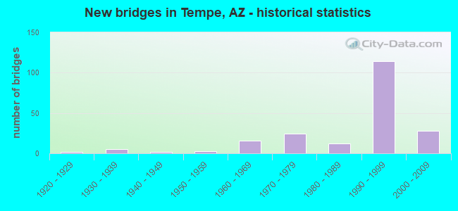
- New bridges - historical statistics
- 21920-1929
- 51930-1939
- 21940-1949
- 31950-1959
- 161960-1969
- 241970-1979
- 121980-1989
- 1141990-1999
- 282000-2009
- 12010-2019
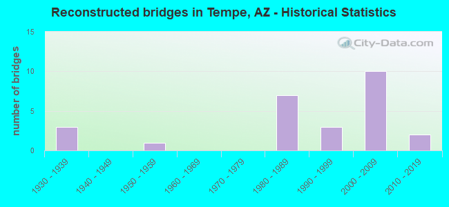
- Reconstructed bridges - Historical Statistics
- 31930-1939
- 01940-1949
- 11950-1959
- 01960-1969
- 01970-1979
- 71980-1989
- 31990-1999
- 102000-2009
- 22010-2019
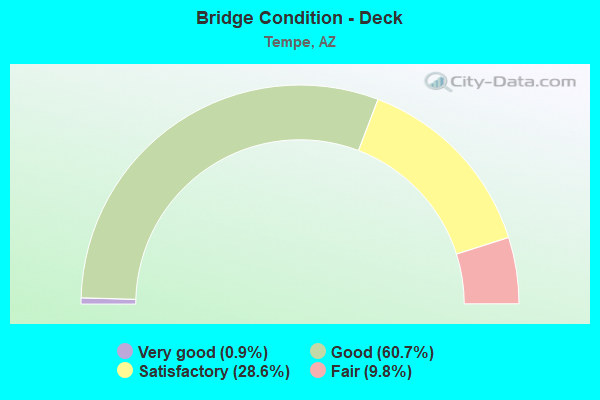
- Bridge Condition - Deck
- 0.9%Very good
- 60.7%Good
- 28.6%Satisfactory
- 9.8%Fair
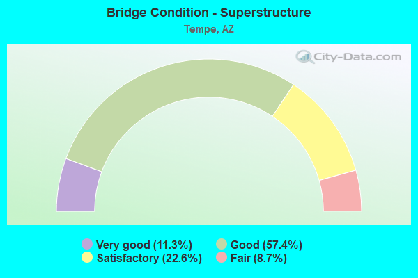
- Bridge Condition - Superstructure
- 11.3%Very good
- 57.4%Good
- 22.6%Satisfactory
- 8.7%Fair
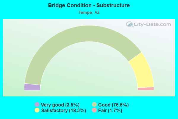
- Bridge Condition - Substructure
- 3.5%Very good
- 76.5%Good
- 18.3%Satisfactory
- 1.7%Fair
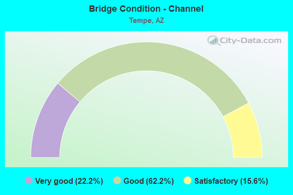
- Bridge Condition - Channel
- 22.2%Very good
- 62.2%Good
- 15.6%Satisfactory
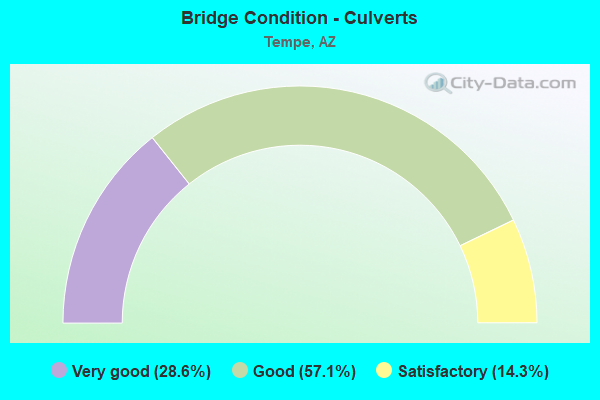
- Bridge Condition - Culverts
- 28.6%Very good
- 57.1%Good
- 14.3%Satisfactory
Find on map >> Show street view
Structure Number: 177, Location: 7.0 mi W Jct SR 74 (Lat: 33.945100, Lng: -112.702000), Route carried "on" structure: US 60, Year Built: 1929, Year Reconstructed: 1938, Status: Open, Structure Length: 1.34m (4.40ft), Average Daily Traffic: 8,707 (year 2020), Truck Traffic: 8%, Average Future Daily Traffic: 8,717 (year 2040), Design Load: HS 20, Features Intersected: Wash
Minimum Vertical Clearance: 30+ m (98+ ft), Kilometerpoint: 181.969, Lanes on structure: 2, Owner: State Highway Agency, Approaching Roadway Width: 11.6m (38.1ft), Material/Design: Concrete continuous, Design/Construction: Slab, Number Of Spans In Main Unit: 2, Length of Maximum Span: 6.1m (20.0ft), Curb-To-Curb Width: 12.4m (40.7ft), Out-to-Out Width: 13.0m (42.7ft)
Condition: Deck: Good, Superstructure: Good, Substructure: Good, Channel: Satisfactory, Operating Rating: 53.5 metric tons, Method Used To Determine Operating Rating: Load Factor (LF), Inventory Rating: 32.7 metric tons, Method Used To Determine Inventory Rating: Load Factor (LF), Structural Evaluation: Better than present minimum criteria, Deck Geometry: Better than present minimum criteria, Waterway Adequacy: Better than present minimum criteria, Approach Roadway Alignment: Equal to present desirable criteria, Designated Inspection Frequency: Every 24 months, Inspection Date: November 2021, Deck Structure Type: Concrete Cast-file-Place, Wearing Surface/Protective System: Wearing Surface: Bituminous
Find on map >> Show street view
Structure Number: 21, Location: 33.4 mi E Jct US 191 (Lat: 32.235903, Lng: -109.077008), Route carried "on" structure: Interstate 10, Year Built: 1938, Status: Open, Structure Length: 3.08m (10.10ft), Average Daily Traffic: 5,195 (year 2018), Truck Traffic: 19%, Average Future Daily Traffic: 5,205 (year 2038), Design Load: H 15, Features Intersected: Island Wash
Minimum Vertical Clearance: 30+ m (98+ ft), Kilometerpoint: 626.646, Lanes on structure: 2, Owner: State Highway Agency, Approaching Roadway Width: 11.0m (36.1ft), Material/Design: Concrete continuous, Design/Construction: Slab, Number Of Spans In Main Unit: 4, Length of Maximum Span: 7.6m (24.9ft), Curb-To-Curb Width: 10.4m (34.1ft), Out-to-Out Width: 11.3m (37.1ft)
Condition: Deck: Satisfactory, Superstructure: Satisfactory, Substructure: Satisfactory, Channel: Satisfactory, Operating Rating: 38.1 metric tons, Method Used To Determine Operating Rating: Load Factor (LF), Inventory Rating: 22.7 metric tons, Method Used To Determine Inventory Rating: Load Factor (LF), Structural Evaluation: Somewhat better than minimum adequacy, Deck Geometry: Meets minimum limits, Waterway Adequacy: Equal to present desirable criteria, Approach Roadway Alignment: Equal to present desirable criteria, Length Of Structure Improvement: 3.90m (12.80ft), Designated Inspection Frequency: Every 24 months, Inspection Date: September 2021, Total Project Cost: $1,000 ( Estimate for 2019), Deck Structure Type: Concrete Cast-file-Place, Wearing Surface/Protective System: Wearing Surface: Bituminous
Find on map >> Show street view
Structure Number: 235, Location: 5.6 mi E Jct SR 92 (Lat: 31.430872, Lng: -109.810608), Route carried "on" structure: State highway 80, Year Built: 1920, Year Reconstructed: 1936, Status: Open, Structure Length: 1.10m (3.61ft), Average Daily Traffic: 4,474 (year 2017), Truck Traffic: 10%, Average Future Daily Traffic: 4,484 (year 2038), Design Load: HS 20, Features Intersected: Wash
Minimum Vertical Clearance: 30+ m (98+ ft), Kilometerpoint: 562.112, Lanes on structure: 2, Owner: State Highway Agency, Approaching Roadway Width: 11.0m (36.1ft), Material/Design: Concrete continuous, Design/Construction: Slab, Number Of Spans In Main Unit: 2, Length of Maximum Span: 5.2m (17.1ft), Curb-To-Curb Width: 11.0m (36.1ft), Out-to-Out Width: 12.9m (42.3ft)
Condition: Deck: Fair, Superstructure: Fair, Substructure: Satisfactory, Channel: Good, Operating Rating: 45.4 metric tons, Method Used To Determine Operating Rating: Load Factor (LF), Inventory Rating: 27.2 metric tons, Method Used To Determine Inventory Rating: Load Factor (LF), Structural Evaluation: Somewhat better than minimum adequacy, Deck Geometry: Somewhat better than minimum adequacy, Waterway Adequacy: Equal to present desirable criteria, Approach Roadway Alignment: Equal to present desirable criteria, Length Of Structure Improvement: 1.86m (6.10ft), Designated Inspection Frequency: Every 24 months, Inspection Date: May 2020, Total Project Cost: $1,000 ( Estimate for 2020), Deck Structure Type: Concrete Cast-file-Place, Wearing Surface/Protective System: Wearing Surface: Bituminous
Find on map >> Show street view
Structure Number: 238, Location: 9.6 mi W Jct US 191 (Lat: 31.375606, Lng: -109.738342), Route carried "on" structure: State highway 80, Year Built: 1940, Status: Open, Structure Length: 3.23m (10.60ft), Average Daily Traffic: 4,474 (year 2017), Truck Traffic: 10%, Average Future Daily Traffic: 4,484 (year 2038), Design Load: HS 20, Features Intersected: Wash
Minimum Vertical Clearance: 30+ m (98+ ft), Kilometerpoint: 571.398, Lanes on structure: 2, Owner: State Highway Agency, Approaching Roadway Width: 11.3m (37.1ft), Material/Design: Concrete continuous, Design/Construction: Slab, Number Of Spans In Main Unit: 4, Length of Maximum Span: 7.9m (25.9ft), Curb or Sidewalk Widths: Left: 0.2m (0.7ft), Right: 0.2m (0.7ft), Curb-To-Curb Width: 11.3m (37.1ft), Out-to-Out Width: 13.0m (42.7ft)
Condition: Deck: Satisfactory, Superstructure: Satisfactory, Substructure: Satisfactory, Channel: Satisfactory, Operating Rating: 38.1 metric tons, Method Used To Determine Operating Rating: Load Factor (LF), Inventory Rating: 22.7 metric tons, Method Used To Determine Inventory Rating: Load Factor (LF), Structural Evaluation: Equal to present minimum criteria, Deck Geometry: Somewhat better than minimum adequacy, Waterway Adequacy: Equal to present desirable criteria, Approach Roadway Alignment: Equal to present desirable criteria, Length Of Structure Improvement: 4.05m (13.29ft), Designated Inspection Frequency: Every 24 months, Inspection Date: May 2020, Total Project Cost: $1,000 ( Estimate for 2020), Deck Structure Type: Concrete Cast-file-Place, Wearing Surface/Protective System: Wearing Surface: Bituminous
Find on map >> Show street view
Structure Number: 264, Location: 2.0 mi E Jct I-10 (Lat: 31.966500, Lng: -110.289900), Route carried "on" structure: , Year Built: 1941, Status: Open, Structure Length: 1.74m (5.71ft), Design Load: Railroad, Features Intersected: SR B 10, Facility Carried by Structure: Benson SPRR
Kilometerpoint: 0.000, Lanes under structure: 2, Owner: Railroad, Maintenance Responsibility: State Highway Agency, Skew: 5 degrees, Material/Design: Concrete continuous, Design/Construction: Frame, Number Of Spans In Main Unit: 2, Length of Maximum Span: 7.3m (24.0ft), Out-to-Out Width: 43.2m (141.7ft)
Condition: Superstructure: Satisfactory, Substructure: Good, Operating Rating: 65.3 metric tons, Method Used To Determine Operating Rating: Allowable Stress (AS), Inventory Rating: 65.3 metric tons, Method Used To Determine Inventory Rating: Allowable Stress (AS), Structural Evaluation: Equal to present minimum criteria, Underclear: High priority of corrective action, Designated Inspection Frequency: Every 24 months, Inspection Date: Febuary 2021
Find on map >> Show street view
Structure Number: 1045, Location: 7.3 mi E Jct I-19 (Lat: 32.129072, Lng: -110.880886), Route carried "on" structure: Interstate 10, Year Built: 1958, Year Reconstructed: 1985, Status: Open, Structure Length: 2.87m (9.42ft), Average Daily Traffic: 71,000 (year 2020), Truck Traffic: 15%, Average Future Daily Traffic: 71,010 (year 2040), Design Load: HS 20, Features Intersected: Earp Wash Trib
Minimum Vertical Clearance: 30+ m (98+ ft), Kilometerpoint: 430.741, Lanes on structure: 3, Owner: State Highway Agency, Approaching Roadway Width: 14.9m (48.9ft), Material/Design: Concrete continuous, Design/Construction: Slab, Number Of Spans In Main Unit: 4, Length of Maximum Span: 7.6m (24.9ft), Curb-To-Curb Width: 14.9m (48.9ft), Out-to-Out Width: 15.8m (51.8ft)
Condition: Deck: Good, Superstructure: Good, Substructure: Good, Channel: Good, Operating Rating: 37.2 metric tons, Method Used To Determine Operating Rating: Load Factor (LF), Inventory Rating: 21.8 metric tons, Method Used To Determine Inventory Rating: Load Factor (LF), Structural Evaluation: Somewhat better than minimum adequacy, Deck Geometry: Meets minimum limits, Waterway Adequacy: Better than present minimum criteria, Approach Roadway Alignment: Equal to present desirable criteria, Designated Inspection Frequency: Every 24 months, Inspection Date: January 2022, Deck Structure Type: Concrete Cast-file-Place, Wearing Surface/Protective System: Wearing Surface: Monolithic Concrete
Find on map >> Show street view
Structure Number: 1144, Location: 0.3 mi W Jct US 60 (Lat: 33.393069, Lng: -111.967828), Route carried "on" structure: Interstate 10, Year Built: 1966, Year Reconstructed: 2005, Status: Open, Structure Length: 4.24m (13.91ft), Average Daily Traffic: 79,660 (year 2017), Truck Traffic: 4%, Average Future Daily Traffic: 79,670 (year 2037), Design Load: HS 20, Features Intersected: Southern Avenue
Minimum Vertical Clearance: 30+ m (98+ ft), Kilometerpoint: 249.448, Lanes on structure: 4, Lanes under structure: 5, Owner: State Highway Agency, Approaching Roadway Width: 19.8m (65.0ft), Material/Design: Concrete, Design/Construction: Box Beam or Girders - Single/Spread, Number Of Spans In Main Unit: 3, Length of Maximum Span: 26.5m (86.9ft), Curb-To-Curb Width: 19.8m (65.0ft), Out-to-Out Width: 31.5m (103.3ft)
Condition: Deck: Satisfactory, Superstructure: Satisfactory, Substructure: Good, Operating Rating: 89.8 metric tons, Method Used To Determine Operating Rating: Load Factor (LF), Inventory Rating: 71.7 metric tons, Method Used To Determine Inventory Rating: Load Factor (LF), Structural Evaluation: Equal to present minimum criteria, Deck Geometry: Equal to present minimum criteria, Underclear: Meets minimum limits, Approach Roadway Alignment: Equal to present desirable criteria, Designated Inspection Frequency: Every 24 months, Inspection Date: Febuary 2021, Deck Structure Type: Concrete Cast-file-Place, Wearing Surface/Protective System: Wearing Surface: Bituminous
Find on map >> Show street view
Structure Number: 1211, Location: 1.4 mi W Jct US 60 (Lat: 33.408700, Lng: -111.972900), Route carried "on" structure: City street , Year Built: 1965, Year Reconstructed: 1992, Status: Open, Structure Length: 10.09m (33.10ft), Average Daily Traffic: 33,822 (year 2019), Truck Traffic: 10%, Average Future Daily Traffic: 33,832 (year 2039), Design Load: HS 20, Features Intersected: I 10, Facility Carried by Structure: Broadway Road
Minimum Vertical Clearance: 30+ m (98+ ft), Kilometerpoint: 246.986, Lanes on structure: 7, Lanes under structure: 13, Owner: State Highway Agency, Approaching Roadway Width: 26.8m (87.9ft), Skew: 23 degrees, Material/Design: Steel continuous, Design/Construction: Stringer/Multi-beam, Number Of Spans In Main Unit: 4, Length of Maximum Span: 33.5m (109.9ft), Curb or Sidewalk Widths: Left: 0.0m, Right: 1.5m (4.9ft), Curb-To-Curb Width: 26.7m (87.6ft), Out-to-Out Width: 29.6m (97.1ft)
Condition: Deck: Fair, Superstructure: Good, Substructure: Good, Operating Rating: 54.4 metric tons, Method Used To Determine Operating Rating: Load Factor (LF), Inventory Rating: 32.7 metric tons, Method Used To Determine Inventory Rating: Load Factor (LF), Structural Evaluation: Better than present minimum criteria, Deck Geometry: Meets minimum limits, Underclear: High priority of corrective action, Approach Roadway Alignment: Equal to present desirable criteria, Designated Inspection Frequency: Every 24 months, Inspection Date: July 2020, Deck Structure Type: Concrete Cast-file-Place, Wearing Surface/Protective System: Wearing Surface: Monolithic Concrete
Find on map >> Show street view
Structure Number: 1376, Location: 0.9 mi E Jct I 10 (Lat: 33.385300, Lng: -111.952300), Route carried "on" structure: City street , Year Built: 1969, Status: Open, Structure Length: 6.25m (20.51ft), Average Daily Traffic: 12,766 (year 2019), Truck Traffic: 2%, Average Future Daily Traffic: 12,776 (year 2039), Design Load: HS 20, Features Intersected: US 60, Facility Carried by Structure: Hardy Dr
Minimum Vertical Clearance: 5.69m (18.67ft), Kilometerpoint: 0.000, Lanes on structure: 2, Lanes under structure: 12, Owner: State Highway Agency, Approaching Roadway Width: 12.2m (40.0ft), Material/Design: Concrete continuous, Design/Construction: Box Beam or Girders - Single/Spread, Number Of Spans In Main Unit: 2, Length of Maximum Span: 30.5m (100.1ft), Curb or Sidewalk Widths: Left: 1.6m (5.2ft), Right: 1.6m (5.2ft), Curb-To-Curb Width: 12.2m (40.0ft), Out-to-Out Width: 16.0m (52.5ft)
Condition: Deck: Fair, Superstructure: Fair, Substructure: Good, Operating Rating: 88.0 metric tons, Method Used To Determine Operating Rating: Load Factor (LF), Inventory Rating: 52.6 metric tons, Method Used To Determine Inventory Rating: Load Factor (LF), Structural Evaluation: Somewhat better than minimum adequacy, Deck Geometry: Somewhat better than minimum adequacy, Underclear: High priority of replacement, Approach Roadway Alignment: Equal to present desirable criteria, Length Of Structure Improvement: 7.16m (23.49ft), Designated Inspection Frequency: Every 24 months, Inspection Date: October 2021, Bridge Improvement Cost: $1,000, Total Project Cost: $2,000 ( Estimate for 2015), Deck Structure Type: Concrete Cast-file-Place, Wearing Surface/Protective System: Wearing Surface: Monolithic Concrete
Find on map >> Show street view
Structure Number: 1377, Location: 4.3 mi E Jct I 10 (Lat: 33.385200, Lng: -111.943500), Route carried "on" structure: , Year Built: 1969, Status: Open, Structure Length: 6.22m (20.41ft), Design Load: Railroad, Features Intersected: US 60, Facility Carried by Structure: SPRR Kyrene
Kilometerpoint: 0.000, Lanes under structure: 12, Owner: Railroad, Maintenance Responsibility: State Highway Agency, Material/Design: Prestressed concrete continuous, Design/Construction: Box Beam or Girders - Single/Spread, Number Of Spans In Main Unit: 2, Length of Maximum Span: 30.2m (99.1ft), Out-to-Out Width: 5.6m (18.4ft)
Condition: Superstructure: Good, Substructure: Good, Structural Evaluation: Better than present minimum criteria, Underclear: High priority of corrective action, Designated Inspection Frequency: Every 24 months, Inspection Date: October 2021, Deck Structure Type: Concrete Cast-file-Place, Wearing Surface/Protective System: Wearing Surface: Gravel, Membrane: Other
Find on map >> Show street view
Structure Number: 1378, Location: 1.4 E Jct I 10 (Lat: 33.385300, Lng: -111.943700), Route carried "on" structure: City street , Year Built: 1969, Status: Open, Structure Length: 6.25m (20.51ft), Average Daily Traffic: 5,602 (year 2019), Truck Traffic: 1%, Average Future Daily Traffic: 5,612 (year 2039), Design Load: HS 20, Features Intersected: US 60, Facility Carried by Structure: Kyrene Rd
Minimum Vertical Clearance: 30+ m (98+ ft), Kilometerpoint: 0.000, Lanes on structure: 2, Lanes under structure: 12, Owner: State Highway Agency, Approaching Roadway Width: 12.2m (40.0ft), Material/Design: Concrete continuous, Design/Construction: Box Beam or Girders - Single/Spread, Number Of Spans In Main Unit: 2, Length of Maximum Span: 30.5m (100.1ft), Curb or Sidewalk Widths: Left: 1.6m (5.2ft), Right: 1.6m (5.2ft), Curb-To-Curb Width: 12.2m (40.0ft), Out-to-Out Width: 16.0m (52.5ft)
Condition: Deck: Satisfactory, Superstructure: Fair, Substructure: Satisfactory, Operating Rating: 58.1 metric tons, Method Used To Determine Operating Rating: Load Factor (LF), Inventory Rating: 35.4 metric tons, Method Used To Determine Inventory Rating: Load Factor (LF), Structural Evaluation: Somewhat better than minimum adequacy, Deck Geometry: Somewhat better than minimum adequacy, Underclear: High priority of corrective action, Approach Roadway Alignment: Equal to present desirable criteria, Designated Inspection Frequency: Every 24 months, Inspection Date: October 2021, Deck Structure Type: Concrete Cast-file-Place, Wearing Surface/Protective System: Wearing Surface: Monolithic Concrete
Find on map >> Show street view
Structure Number: 166, Location: 2.42 mi E Jct I 10 (Lat: 33.385300, Lng: -111.926500), Route carried "on" structure: City street , Year Built: 1975, Status: Open, Structure Length: 6.37m (20.90ft), Average Daily Traffic: 40,980 (year 2019), Truck Traffic: 3%, Average Future Daily Traffic: 40,990 (year 2039), Design Load: HS 20, Features Intersected: US 60, Facility Carried by Structure: Rural Road
Minimum Vertical Clearance: 30+ m (98+ ft), Kilometerpoint: 0.000, Lanes on structure: 9, Lanes under structure: 10, Owner: State Highway Agency, Approaching Roadway Width: 31.1m (102.0ft), Skew: 20 degrees, Material/Design: Concrete continuous, Design/Construction: Box Beam or Girders - Single/Spread, Number Of Spans In Main Unit: 2, Length of Maximum Span: 31.1m (102.0ft), Curb or Sidewalk Widths: Left: 0.0m, Right: 2.5m (8.2ft), Curb-To-Curb Width: 31.9m (104.7ft), Out-to-Out Width: 35.6m (116.8ft)
Condition: Deck: Fair, Superstructure: Fair, Substructure: Satisfactory, Operating Rating: 68.0 metric tons, Method Used To Determine Operating Rating: Load Factor (LF), Inventory Rating: 40.8 metric tons, Method Used To Determine Inventory Rating: Load Factor (LF), Structural Evaluation: Somewhat better than minimum adequacy, Deck Geometry: High priority of replacement, Underclear: Somewhat better than minimum adequacy, Approach Roadway Alignment: Equal to present desirable criteria, Length Of Structure Improvement: 7.28m (23.88ft), Designated Inspection Frequency: Every 24 months, Inspection Date: October 2021, Bridge Improvement Cost: $2,000, Roadway Improvement Cost: $1,000, Total Project Cost: $3,000 ( Estimate for 2019), Deck Structure Type: Concrete Cast-file-Place, Wearing Surface/Protective System: Wearing Surface: Monolithic Concrete
Find on map >> Show street view
Structure Number: 1661, Location: 3.42 mi E Jct I 10 (Lat: 33.385400, Lng: -111.909200), Route carried "on" structure: City street , Year Built: 1975, Status: Open, Structure Length: 6.37m (20.90ft), Average Daily Traffic: 38,230 (year 2019), Truck Traffic: 3%, Average Future Daily Traffic: 38,240 (year 2039), Design Load: HS 20, Features Intersected: US 60, Facility Carried by Structure: McClintock Dr
Minimum Vertical Clearance: 30+ m (98+ ft), Kilometerpoint: 0.000, Lanes on structure: 9, Lanes under structure: 12, Owner: State Highway Agency, Approaching Roadway Width: 31.4m (103.0ft), Skew: 20 degrees, Material/Design: Concrete continuous, Design/Construction: Box Beam or Girders - Single/Spread, Number Of Spans In Main Unit: 2, Length of Maximum Span: 31.1m (102.0ft), Curb or Sidewalk Widths: Left: 0.0m, Right: 2.5m (8.2ft), Curb-To-Curb Width: 31.9m (104.7ft), Out-to-Out Width: 35.6m (116.8ft)
Condition: Deck: Fair, Superstructure: Fair, Substructure: Satisfactory, Operating Rating: 68.0 metric tons, Method Used To Determine Operating Rating: Load Factor (LF), Inventory Rating: 40.8 metric tons, Method Used To Determine Inventory Rating: Load Factor (LF), Structural Evaluation: Somewhat better than minimum adequacy, Deck Geometry: High priority of replacement, Underclear: High priority of corrective action, Approach Roadway Alignment: Equal to present desirable criteria, Length Of Structure Improvement: 7.28m (23.88ft), Designated Inspection Frequency: Every 24 months, Inspection Date: October 2021, Bridge Improvement Cost: $2,000, Roadway Improvement Cost: $1,000, Total Project Cost: $3,000 ( Estimate for 2019), Deck Structure Type: Concrete Cast-file-Place, Wearing Surface/Protective System: Wearing Surface: Monolithic Concrete
Find on map >> Show street view
Structure Number: 1734, Location: Jct SR 169 (Lat: 34.514400, Lng: -111.992700), Route carried "on" structure: State highway 169, Year Built: 1976, Status: Open, Structure Length: 7.80m (25.59ft), Average Daily Traffic: 2,933 (year 2019), Truck Traffic: 11%, Average Future Daily Traffic: 2,943 (year 2039), Design Load: HS 20, Features Intersected: I-17
Minimum Vertical Clearance: 30+ m (98+ ft), Kilometerpoint: 24.269, Lanes on structure: 2, Lanes under structure: 4, Owner: State Highway Agency, Approaching Roadway Width: 10.4m (34.1ft), Skew: 2 degrees, Material/Design: Steel continuous, Design/Construction: Stringer/Multi-beam, Number Of Spans In Main Unit: 2, Length of Maximum Span: 39.9m (130.9ft), Curb-To-Curb Width: 11.6m (38.1ft), Out-to-Out Width: 12.4m (40.7ft)
Condition: Deck: Fair, Superstructure: Satisfactory, Substructure: Good, Operating Rating: 66.2 metric tons, Method Used To Determine Operating Rating: Load Factor (LF), Inventory Rating: 39.9 metric tons, Method Used To Determine Inventory Rating: Load Factor (LF), Structural Evaluation: Equal to present minimum criteria, Deck Geometry: Somewhat better than minimum adequacy, Underclear: Better than present minimum criteria, Approach Roadway Alignment: Equal to present minimum criteria, Designated Inspection Frequency: Every 24 months, Inspection Date: September 2021, Deck Structure Type: Concrete Cast-file-Place, Wearing Surface/Protective System: Wearing Surface: Monolithic Concrete
Find on map >> Show street view
Structure Number: 174, Location: 23.0 mi N Jct SR 289 (Lat: 31.735600, Lng: -111.052800), Route carried "on" structure: Interstate 19, Year Built: 1977, Status: Open, Structure Length: 3.93m (12.89ft), Average Daily Traffic: 9,460 (year 2018), Truck Traffic: 16%, Average Future Daily Traffic: 9,470 (year 2038), Design Load: HS 20, Features Intersected: Old Junction Wash
Minimum Vertical Clearance: 30+ m (98+ ft), Kilometerpoint: 49.407, Lanes on structure: 2, Owner: State Highway Agency, Approaching Roadway Width: 11.6m (38.1ft), Skew: 3 degrees, Material/Design: Concrete continuous, Design/Construction: Slab, Number Of Spans In Main Unit: 4, Length of Maximum Span: 10.7m (35.1ft), Curb-To-Curb Width: 12.8m (42.0ft), Out-to-Out Width: 13.6m (44.6ft)
Condition: Deck: Satisfactory, Superstructure: Satisfactory, Substructure: Satisfactory, Channel: Satisfactory, Operating Rating: 62.6 metric tons, Method Used To Determine Operating Rating: Load Factor (LF), Inventory Rating: 37.2 metric tons, Method Used To Determine Inventory Rating: Load Factor (LF), Structural Evaluation: Equal to present minimum criteria, Deck Geometry: Equal to present desirable criteria, Waterway Adequacy: Better than present minimum criteria, Approach Roadway Alignment: Equal to present desirable criteria, Designated Inspection Frequency: Every 24 months, Inspection Date: April 2021, Deck Structure Type: Concrete Cast-file-Place, Wearing Surface/Protective System: Wearing Surface: Bituminous
Find on map >> Show street view
Structure Number: 1742, Location: 23.0 mi N Jct SR 289 (Lat: 31.735600, Lng: -111.052400), Route carried "on" structure: ServiceState highway 19, Year Built: 1977, Status: Open, Structure Length: 3.93m (12.89ft), Average Daily Traffic: 2,037 (year 2018), Truck Traffic: 16%, Average Future Daily Traffic: 2,047 (year 2038), Design Load: HS 20, Features Intersected: Old Junction Wash
Minimum Vertical Clearance: 30+ m (98+ ft), Kilometerpoint: 49.407, Lanes on structure: 2, Owner: State Highway Agency, Approaching Roadway Width: 7.9m (25.9ft), Skew: 3 degrees, Material/Design: Concrete continuous, Design/Construction: Slab, Number Of Spans In Main Unit: 4, Length of Maximum Span: 10.7m (35.1ft), Curb-To-Curb Width: 7.9m (25.9ft), Out-to-Out Width: 8.7m (28.5ft)
Condition: Deck: Satisfactory, Superstructure: Satisfactory, Substructure: Satisfactory, Channel: Good, Operating Rating: 63.5 metric tons, Method Used To Determine Operating Rating: Load Factor (LF), Inventory Rating: 38.1 metric tons, Method Used To Determine Inventory Rating: Load Factor (LF), Structural Evaluation: Equal to present minimum criteria, Deck Geometry: High priority of corrective action, Waterway Adequacy: Better than present minimum criteria, Approach Roadway Alignment: Better than present minimum criteria, Designated Inspection Frequency: Every 24 months, Inspection Date: April 2021, Deck Structure Type: Concrete Cast-file-Place, Wearing Surface/Protective System: Wearing Surface: Monolithic Concrete
Find on map >> Show street view
Structure Number: 1767, Location: 0.1 mi W Jct SR 89 (Lat: 35.220100, Lng: -112.476100), Route carried "on" structure: Ramp Interstate 40, Year Built: 1980, Status: Open, Structure Length: 4.45m (14.60ft), Average Daily Traffic: 1,529 (year 2018), Truck Traffic: 24%, Average Future Daily Traffic: 1,539 (year 2038), Design Load: HS 20, Features Intersected: Ash Fork Creek
Minimum Vertical Clearance: 30+ m (98+ ft), Kilometerpoint: 235.206, Lanes on structure: 1, Owner: State Highway Agency, Approaching Roadway Width: 6.7m (22.0ft), Material/Design: Concrete continuous, Design/Construction: Tee Beam, Number Of Spans In Main Unit: 2, Length of Maximum Span: 21.9m (71.9ft), Curb-To-Curb Width: 7.9m (25.9ft), Out-to-Out Width: 8.7m (28.5ft)
Condition: Deck: Satisfactory, Superstructure: Good, Substructure: Good, Channel: Good, Operating Rating: 89.8 metric tons, Method Used To Determine Operating Rating: Load Factor (LF), Inventory Rating: 69.9 metric tons, Method Used To Determine Inventory Rating: Load Factor (LF), Structural Evaluation: Better than present minimum criteria, Deck Geometry: Equal to present desirable criteria, Waterway Adequacy: Equal to present desirable criteria, Approach Roadway Alignment: Equal to present desirable criteria, Designated Inspection Frequency: Every 24 months, Inspection Date: May 2020, Deck Structure Type: Concrete Cast-file-Place, Wearing Surface/Protective System: Wearing Surface: Epoxy Overlay
Find on map >> Show street view
Structure Number: 1771, Location: 19.6 mi E Jct US 93 (Lat: 35.190500, Lng: -113.365200), Route carried "on" structure: County highway , Year Built: 1975, Status: Open, Structure Length: 7.47m (24.51ft), Average Daily Traffic: 110 (year 2020), Truck Traffic: 1%, Average Future Daily Traffic: 120 (year 2040), Design Load: HS 20, Features Intersected: I-40, Facility Carried by Structure: Fort Rock Road
Minimum Vertical Clearance: 30+ m (98+ ft), Kilometerpoint: 0.000, Lanes on structure: 2, Lanes under structure: 4, Owner: State Highway Agency, Approaching Roadway Width: 7.9m (25.9ft), Material/Design: Concrete continuous, Design/Construction: Box Beam or Girders - Single/Spread, Number Of Spans In Main Unit: 2, Length of Maximum Span: 37.2m (122.0ft), Curb-To-Curb Width: 7.9m (25.9ft), Out-to-Out Width: 8.7m (28.5ft)
Condition: Deck: Fair, Superstructure: Satisfactory, Substructure: Good, Operating Rating: 60.8 metric tons, Method Used To Determine Operating Rating: Load Factor (LF), Inventory Rating: 36.3 metric tons, Method Used To Determine Inventory Rating: Load Factor (LF), Structural Evaluation: Equal to present minimum criteria, Deck Geometry: Somewhat better than minimum adequacy, Underclear: Better than present minimum criteria, Approach Roadway Alignment: Equal to present minimum criteria, Designated Inspection Frequency: Every 24 months, Inspection Date: June 2020, Deck Structure Type: Concrete Cast-file-Place, Wearing Surface/Protective System: Wearing Surface: Monolithic Concrete
Find on map >> Show street view
Structure Number: 1791, Location: 4.42 mi E Jct I 10 (Lat: 33.385400, Lng: -111.892400), Route carried "on" structure: ServiceState highway 101, Year Built: 1977, Status: Open, Structure Length: 6.92m (22.70ft), Average Daily Traffic: 9,543 (year 2021), Truck Traffic: 7%, Average Future Daily Traffic: 9,553 (year 2041), Design Load: HS 20, Features Intersected: US 60, Facility Carried by Structure: Price Road South
Minimum Vertical Clearance: 30+ m (98+ ft), Kilometerpoint: 88.707, Lanes on structure: 2, Lanes under structure: 9, Owner: State Highway Agency, Approaching Roadway Width: 12.2m (40.0ft), Material/Design: Prestressed concrete continuous, Design/Construction: Box Beam or Girders - Single/Spread, Number Of Spans In Main Unit: 2, Length of Maximum Span: 34.1m (111.9ft), Curb or Sidewalk Widths: Left: 3.0m (9.8ft), Right: 3.0m (9.8ft), Curb-To-Curb Width: 12.2m (40.0ft), Out-to-Out Width: 32.6m (107.0ft)
Condition: Deck: Satisfactory, Superstructure: Good, Substructure: Good, Operating Rating: 84.4 metric tons, Method Used To Determine Operating Rating: Load Factor (LF), Inventory Rating: 44.5 metric tons, Method Used To Determine Inventory Rating: Load Factor (LF), Structural Evaluation: Better than present minimum criteria, Deck Geometry: Better than present minimum criteria, Underclear: Meets minimum limits, Approach Roadway Alignment: Equal to present desirable criteria, Designated Inspection Frequency: Every 24 months, Inspection Date: December 2021, Deck Structure Type: Concrete Cast-file-Place, Wearing Surface/Protective System: Wearing Surface: Monolithic Concrete
Find on map >> Show street view
Structure Number: 1792, Location: 4.49 mi E Jct I 10 (Lat: 33.385500, Lng: -111.891300), Route carried "on" structure: State highway 101, Year Built: 1977, Year Reconstructed: 1993, Status: Open, Structure Length: 4.88m (16.01ft), Average Daily Traffic: 100,339 (year 2020), Truck Traffic: 5%, Average Future Daily Traffic: 100,349 (year 2040), Design Load: HS 20, Features Intersected: US 60
Minimum Vertical Clearance: 5.67m (18.60ft), Kilometerpoint: 88.710, Lanes on structure: 5, Lanes under structure: 8, Owner: State Highway Agency, Approaching Roadway Width: 21.3m (69.9ft), Material/Design: Prestressed concrete continuous, Design/Construction: Box Beam or Girders - Single/Spread, Number Of Spans In Main Unit: 2, Length of Maximum Span: 24.1m (79.1ft), Curb-To-Curb Width: 21.3m (69.9ft), Out-to-Out Width: 34.0m (111.5ft)
Condition: Deck: Good, Superstructure: Good, Substructure: Satisfactory, Operating Rating: 89.8 metric tons, Method Used To Determine Operating Rating: Load Factor (LF), Inventory Rating: 89.8 metric tons, Method Used To Determine Inventory Rating: Load Factor (LF), Structural Evaluation: Equal to present minimum criteria, Deck Geometry: Meets minimum limits, Underclear: Somewhat better than minimum adequacy, Approach Roadway Alignment: Equal to present desirable criteria, Designated Inspection Frequency: Every 24 months, Inspection Date: December 2021, Deck Structure Type: Concrete Cast-file-Place, Wearing Surface/Protective System: Wearing Surface: Bituminous
Find on map >> Show street view
Structure Number: 1801, Location: 0.4 mi North Jct I 10 (Lat: 33.416700, Lng: -111.978200), Route carried "on" structure: State highway 143, Year Built: 1978, Year Reconstructed: 2001, Status: Open, Structure Length: 1.62m (5.31ft), Average Daily Traffic: 81,000 (year 2018), Truck Traffic: 12%, Average Future Daily Traffic: 85,625 (year 2040), Design Load: HS 20, Features Intersected: Tempe Dr Ditch #2
Minimum Vertical Clearance: 7.62m (25.00ft), Kilometerpoint: 0.644, Lanes on structure: 7, Owner: State Highway Agency, Approaching Roadway Width: 35.1m (115.2ft), Skew: 30 degrees, Material/Design: Prestressed concrete, Design/Construction: Box Beam or Girders - Multiple, Number Of Spans In Main Unit: 1, Length of Maximum Span: 15.2m (49.9ft), Curb-To-Curb Width: 35.0m (114.8ft), Out-to-Out Width: 36.5m (119.8ft)
Condition: Deck: Satisfactory, Superstructure: Good, Substructure: Good, Channel: Good, Operating Rating: 78.9 metric tons, Method Used To Determine Operating Rating: Load Factor (LF), Inventory Rating: 47.2 metric tons, Method Used To Determine Inventory Rating: Load Factor (LF), Structural Evaluation: Better than present minimum criteria, Deck Geometry: Superior to present desirable criteria, Waterway Adequacy: Equal to present desirable criteria, Approach Roadway Alignment: Equal to present desirable criteria, Designated Inspection Frequency: Every 24 months, Inspection Date: May 2021, Deck Structure Type: Concrete Cast-file-Place, Wearing Surface/Protective System: Wearing Surface: Bituminous
Find on map >> Show street view
Structure Number: 2005, Location: 0.7 mi North of Jct I 10 (Lat: 33.421700, Lng: -111.978100), Route carried "on" structure: State highway 143, Year Built: 1984, Status: Open, Structure Length: 6.46m (21.19ft), Average Daily Traffic: 81,000 (year 2018), Truck Traffic: 12%, Average Future Daily Traffic: 85,625 (year 2040), Design Load: HS 20, Features Intersected: University Drive
Minimum Vertical Clearance: 30+ m (98+ ft), Kilometerpoint: 1.223, Lanes on structure: 4, Lanes under structure: 6, Owner: State Highway Agency, Approaching Roadway Width: 23.8m (78.1ft), Skew: 30 degrees, Material/Design: Prestressed concrete, Design/Construction: Box Beam or Girders - Single/Spread, Number Of Spans In Main Unit: 1, Length of Maximum Span: 62.2m (204.1ft), Curb-To-Curb Width: 24.3m (79.7ft), Out-to-Out Width: 26.0m (85.3ft)
Condition: Deck: Good, Superstructure: Good, Substructure: Good, Operating Rating: 88.0 metric tons, Method Used To Determine Operating Rating: Load Factor (LF), Inventory Rating: 36.3 metric tons, Method Used To Determine Inventory Rating: Load Factor (LF), Structural Evaluation: Better than present minimum criteria, Deck Geometry: Superior to present desirable criteria, Underclear: Equal to present desirable criteria, Approach Roadway Alignment: Equal to present desirable criteria, Designated Inspection Frequency: Every 24 months, Inspection Date: May 2021, Deck Structure Type: Concrete Cast-file-Place, Wearing Surface/Protective System: Wearing Surface: Monolithic Concrete
Find on map >> Show street view
Structure Number: 2071, Location: 0.53 mi N of Jct US 60 (Lat: 33.422000, Lng: -111.891700), Route carried "on" structure: City street , Year Built: 1990, Status: Open, Structure Length: 8.99m (29.49ft), Average Daily Traffic: 38,426 (year 2021), Truck Traffic: 3%, Average Future Daily Traffic: 38,436 (year 2041), Design Load: HS 20, Features Intersected: Loop 101, Facility Carried by Structure: University Drive
Minimum Vertical Clearance: 12.19m (39.99ft), Kilometerpoint: 0.000, Lanes on structure: 10, Lanes under structure: 12, Owner: State Highway Agency, Approaching Roadway Width: 36.0m (118.1ft), Skew: 20 degrees, Material/Design: Prestressed concrete continuous, Design/Construction: Box Beam or Girders - Single/Spread, Number Of Spans In Main Unit: 2, Length of Maximum Span: 45.7m (149.9ft), Curb or Sidewalk Widths: Left: 2.4m (7.9ft), Right: 2.4m (7.9ft), Curb-To-Curb Width: 36.0m (118.1ft), Out-to-Out Width: 42.2m (138.5ft)
Condition: Deck: Satisfactory, Superstructure: Satisfactory, Substructure: Good, Operating Rating: 76.2 metric tons, Method Used To Determine Operating Rating: Load Factor (LF), Inventory Rating: 45.4 metric tons, Method Used To Determine Inventory Rating: Load Factor (LF), Structural Evaluation: Equal to present minimum criteria, Deck Geometry: Meets minimum limits, Underclear: Equal to present minimum criteria, Approach Roadway Alignment: Equal to present desirable criteria, Length Of Structure Improvement: 10.00m (32.81ft), Designated Inspection Frequency: Every 24 months, Inspection Date: December 2020, Bridge Improvement Cost: $3,000, Roadway Improvement Cost: $1,000, Total Project Cost: $5,000 ( Estimate for 2020), Deck Structure Type: Concrete Cast-file-Place, Wearing Surface/Protective System: Wearing Surface: Monolithic Concrete
Find on map >> Show street view
Structure Number: 2072, Location: 1.8 mi N of Jct SR 360 (Lat: 33.411100, Lng: -111.891900), Route carried "on" structure: , Year Built: 1990, Status: Open, Structure Length: 10.36m (33.99ft), Design Load: Railroad, Features Intersected: Loop 101, Facility Carried by Structure: SPRR
Kilometerpoint: 0.000, Lanes under structure: 13, Owner: Railroad, Maintenance Responsibility: State Highway Agency, Material/Design: Steel, Design/Construction: Stringer/Multi-beam, Number Of Spans In Main Unit: 2, Length of Maximum Span: 50.3m (165.0ft), Out-to-Out Width: 7.4m (24.3ft)
Condition: Superstructure: Very good, Substructure: Good, Operating Rating: 72.6 metric tons, Method Used To Determine Operating Rating: Allowable Stress (AS), Inventory Rating: 72.6 metric tons, Method Used To Determine Inventory Rating: Allowable Stress (AS), Structural Evaluation: Better than present minimum criteria, Underclear: Meets minimum limits, Designated Inspection Frequency: Every 24 months, Inspection Date: December 2020, Deck Structure Type: Concrete Cast-file-Place, Wearing Surface/Protective System: Wearing Surface: Other, Membrane: Other
Find on map >> Show street view
Structure Number: 2073, Location: 1.5 mi N of Jct SR 360 (Lat: 33.407500, Lng: -111.891700), Route carried "on" structure: City street , Year Built: 1990, Status: Open, Structure Length: 8.69m (28.51ft), Average Daily Traffic: 33,221 (year 2018), Truck Traffic: 7%, Average Future Daily Traffic: 33,231 (year 2038), Design Load: HS 20, Features Intersected: Loop 101, Facility Carried by Structure: Broadway Road
Minimum Vertical Clearance: 12.19m (39.99ft), Kilometerpoint: 0.000, Lanes on structure: 10, Lanes under structure: 10, Owner: State Highway Agency, Approaching Roadway Width: 36.0m (118.1ft), Skew: 20 degrees, Material/Design: Prestressed concrete continuous, Design/Construction: Box Beam or Girders - Single/Spread, Number Of Spans In Main Unit: 2, Length of Maximum Span: 42.7m (140.1ft), Curb or Sidewalk Widths: Left: 2.4m (7.9ft), Right: 2.4m (7.9ft), Curb-To-Curb Width: 36.0m (118.1ft), Out-to-Out Width: 42.2m (138.5ft)
Condition: Deck: Satisfactory, Superstructure: Good, Substructure: Good, Operating Rating: 86.2 metric tons, Method Used To Determine Operating Rating: Load Factor (LF), Inventory Rating: 49.0 metric tons, Method Used To Determine Inventory Rating: Load Factor (LF), Structural Evaluation: Better than present minimum criteria, Deck Geometry: Meets minimum limits, Underclear: Equal to present minimum criteria, Approach Roadway Alignment: Equal to present desirable criteria, Length Of Structure Improvement: 0.03m (0.10ft), Designated Inspection Frequency: Every 24 months, Inspection Date: December 2020, Bridge Improvement Cost: $2,000, Roadway Improvement Cost: $2,000, Total Project Cost: $3,000 ( Estimate for 2020), Deck Structure Type: Concrete Cast-file-Place, Wearing Surface/Protective System: Wearing Surface: Monolithic Concrete
Find on map >> Show street view
Structure Number: 2074, Location: 0.5 mi N of Jct US 60 (Lat: 33.392900, Lng: -111.891700), Route carried "on" structure: City street , Year Built: 1990, Status: Open, Structure Length: 9.60m (31.50ft), Average Daily Traffic: 26,060 (year 2018), Truck Traffic: 3%, Average Future Daily Traffic: 26,070 (year 2038), Design Load: HS 20, Features Intersected: Loop 101, Facility Carried by Structure: Southern Ave
Minimum Vertical Clearance: 7.89m (25.89ft), Kilometerpoint: 0.000, Lanes on structure: 10, Lanes under structure: 12, Owner: State Highway Agency, Approaching Roadway Width: 36.0m (118.1ft), Skew: 20 degrees, Material/Design: Prestressed concrete continuous, Design/Construction: Box Beam or Girders - Single/Spread, Number Of Spans In Main Unit: 2, Length of Maximum Span: 48.8m (160.1ft), Curb or Sidewalk Widths: Left: 2.4m (7.9ft), Right: 2.4m (7.9ft), Curb-To-Curb Width: 36.0m (118.1ft), Out-to-Out Width: 42.2m (138.5ft)
Condition: Deck: Satisfactory, Superstructure: Good, Substructure: Satisfactory, Operating Rating: 72.6 metric tons, Method Used To Determine Operating Rating: Load Factor (LF), Inventory Rating: 32.7 metric tons, Method Used To Determine Inventory Rating: Load Factor (LF), Structural Evaluation: Equal to present minimum criteria, Deck Geometry: Meets minimum limits, Underclear: Equal to present minimum criteria, Approach Roadway Alignment: Equal to present desirable criteria, Length Of Structure Improvement: 10.64m (34.91ft), Designated Inspection Frequency: Every 24 months, Inspection Date: December 2020, Bridge Improvement Cost: $3,000, Roadway Improvement Cost: $1,000, Total Project Cost: $5,000 ( Estimate for 2020), Deck Structure Type: Concrete Cast-file-Place, Wearing Surface/Protective System: Wearing Surface: Monolithic Concrete
Find on map >> Show street view
Structure Number: 21, Location: Center of SR 101/US 60 TI (Lat: 33.385600, Lng: -111.890900), Route carried "on" structure: State highway 101, Year Built: 1998, Status: Open, Structure Length: 4.97m (16.31ft), Average Daily Traffic: 97,376 (year 2020), Truck Traffic: 5%, Average Future Daily Traffic: 97,386 (year 2040), Design Load: HS 20, Features Intersected: US 60
Minimum Vertical Clearance: 6.81m (22.34ft), Kilometerpoint: 88.675, Lanes on structure: 4, Lanes under structure: 8, Owner: State Highway Agency, Approaching Roadway Width: 21.3m (69.9ft), Material/Design: Prestressed concrete continuous, Design/Construction: Box Beam or Girders - Single/Spread, Number Of Spans In Main Unit: 2, Length of Maximum Span: 24.1m (79.1ft), Curb-To-Curb Width: 21.3m (69.9ft), Out-to-Out Width: 22.3m (73.2ft)
Condition: Deck: Good, Superstructure: Very good, Substructure: Good, Operating Rating: 60.8 metric tons, Method Used To Determine Operating Rating: Load Factor (LF), Inventory Rating: 34.5 metric tons, Method Used To Determine Inventory Rating: Load Factor (LF), Structural Evaluation: Better than present minimum criteria, Deck Geometry: Better than present minimum criteria, Underclear: Somewhat better than minimum adequacy, Approach Roadway Alignment: Equal to present desirable criteria, Designated Inspection Frequency: Every 24 months, Inspection Date: December 2021, Deck Structure Type: Concrete Cast-file-Place, Wearing Surface/Protective System: Wearing Surface: Bituminous
Find on map >> Show street view
Structure Number: 2101, Location: 4.55 mi E Jct I 10 (Lat: 33.385400, Lng: -111.890100), Route carried "on" structure: ServiceState highway 101, Year Built: 1993, Status: Open, Structure Length: 6.86m (22.51ft), Average Daily Traffic: 9,813 (year 2020), Truck Traffic: 5%, Average Future Daily Traffic: 9,823 (year 2040), Design Load: HS 20, Features Intersected: US 60 EB & WB, Facility Carried by Structure: Price Road North
Minimum Vertical Clearance: 7.67m (25.16ft), Kilometerpoint: 88.675, Lanes on structure: 2, Lanes under structure: 8, Owner: State Highway Agency, Approaching Roadway Width: 8.5m (27.9ft), Material/Design: Prestressed concrete continuous, Design/Construction: Box Beam or Girders - Single/Spread, Number Of Spans In Main Unit: 2, Length of Maximum Span: 34.1m (111.9ft), Curb or Sidewalk Widths: Left: 0.0m, Right: 2.4m (7.9ft), Curb-To-Curb Width: 8.5m (27.9ft), Out-to-Out Width: 12.1m (39.7ft)
Condition: Deck: Good, Superstructure: Good, Substructure: Good, Operating Rating: 80.7 metric tons, Method Used To Determine Operating Rating: Load Factor (LF), Inventory Rating: 40.8 metric tons, Method Used To Determine Inventory Rating: Load Factor (LF), Structural Evaluation: Better than present minimum criteria, Deck Geometry: High priority of corrective action, Underclear: Equal to present minimum criteria, Approach Roadway Alignment: Equal to present desirable criteria, Length Of Structure Improvement: 7.80m (25.59ft), Designated Inspection Frequency: Every 24 months, Inspection Date: December 2021, Bridge Improvement Cost: $1,000, Total Project Cost: $2,000 ( Estimate for 2019), Deck Structure Type: Concrete Cast-file-Place, Wearing Surface/Protective System: Wearing Surface: Monolithic Concrete
Find on map >> Show street view
Structure Number: 2102, Location: 11 mi E/I 10 - 0.4 S/60 (Lat: 33.378500, Lng: -111.893000), Route carried "on" structure: City street , Year Built: 1997, Status: Open, Structure Length: 7.28m (23.88ft), Average Daily Traffic: 34,657 (year 2018), Truck Traffic: 8%, Average Future Daily Traffic: 34,667 (year 2038), Design Load: HS 20, Features Intersected: SR 101L, Facility Carried by Structure: Baseline Rd
Minimum Vertical Clearance: 8.35m (27.40ft), Kilometerpoint: 0.000, Lanes on structure: 12, Lanes under structure: 10, Owner: State Highway Agency, Approaching Roadway Width: 34.1m (111.9ft), Skew: 20 degrees, Material/Design: Prestressed concrete continuous, Design/Construction: Box Beam or Girders - Single/Spread, Number Of Spans In Main Unit: 2, Length of Maximum Span: 35.7m (117.1ft), Curb or Sidewalk Widths: Left: 1.8m (5.9ft), Right: 1.8m (5.9ft), Curb-To-Curb Width: 34.1m (111.9ft), Out-to-Out Width: 39.2m (128.6ft)
Condition: Deck: Good, Superstructure: Good, Substructure: Good, Operating Rating: 83.5 metric tons, Method Used To Determine Operating Rating: Load Factor (LF), Inventory Rating: 49.9 metric tons, Method Used To Determine Inventory Rating: Load Factor (LF), Structural Evaluation: Better than present minimum criteria, Deck Geometry: High priority of replacement, Underclear: Equal to present minimum criteria, Approach Roadway Alignment: Equal to present desirable criteria, Length Of Structure Improvement: 8.23m (27.00ft), Designated Inspection Frequency: Every 24 months, Inspection Date: December 2020, Bridge Improvement Cost: $2,000, Roadway Improvement Cost: $1,000, Total Project Cost: $4,000 ( Estimate for 2020), Deck Structure Type: Concrete Cast-file-Place, Wearing Surface/Protective System: Wearing Surface: Monolithic Concrete
Find on map >> Show street view
Structure Number: 2103, Location: 4.42 mi E Jct I17 & US 60 (Lat: 33.385300, Lng: -111.888500), Route carried "on" structure: Ramp State highway 101, Year Built: 1994, Year Reconstructed: 2000, Status: Open, Structure Length: 63.86m (209.51ft), Average Daily Traffic: 38,554 (year 2020), Truck Traffic: 5%, Average Future Daily Traffic: 38,564 (year 2040), Design Load: HS 20, Features Intersected: US 60, L101, N Price Rd
Minimum Vertical Clearance: 30+ m (98+ ft), Kilometerpoint: 88.710, Lanes on structure: 2, Lanes under structure: 20, Owner: State Highway Agency, Approaching Roadway Width: 11.0m (36.1ft), Material/Design: Prestressed concrete continuous, Design/Construction: Box Beam or Girders - Single/Spread, Number Of Spans In Main Unit: 16, Length of Maximum Span: 70.1m (230.0ft), Curb-To-Curb Width: 11.0m (36.1ft), Out-to-Out Width: 11.9m (39.0ft)
Condition: Deck: Good, Superstructure: Fair, Substructure: Good, Operating Rating: 78.9 metric tons, Method Used To Determine Operating Rating: Load Factor (LF), Inventory Rating: 47.2 metric tons, Method Used To Determine Inventory Rating: Load Factor (LF), Structural Evaluation: Somewhat better than minimum adequacy, Deck Geometry: Better than present minimum criteria, Underclear: High priority of corrective action, Approach Roadway Alignment: Equal to present desirable criteria, Designated Inspection Frequency: Every 24 months, Inspection Date: December 2021, Deck Structure Type: Concrete Cast-file-Place, Wearing Surface/Protective System: Wearing Surface: Bituminous
Find on map >> Show street view
Structure Number: 2104, Location: SR 101/US 60 TI (Lat: 33.384600, Lng: -111.890500), Route carried "on" structure: Ramp State highway 101, Year Built: 1997, Status: Open, Structure Length: 51.85m (170.11ft), Average Daily Traffic: 20,922 (year 2020), Truck Traffic: 7%, Average Future Daily Traffic: 20,932 (year 2040), Design Load: HS 20, Features Intersected: NB/SB 101L &EB/WB US60, Facility Carried by Structure: Ramp S to W
Minimum Vertical Clearance: 30+ m (98+ ft), Kilometerpoint: 88.710, Lanes on structure: 2, Lanes under structure: 13, Owner: State Highway Agency, Approaching Roadway Width: 11.0m (36.1ft), Material/Design: Prestressed concrete continuous, Design/Construction: Box Beam or Girders - Single/Spread, Number Of Spans In Main Unit: 12, Length of Maximum Span: 54.6m (179.1ft), Curb-To-Curb Width: 11.0m (36.1ft), Out-to-Out Width: 11.9m (39.0ft)
Condition: Deck: Good, Superstructure: Satisfactory, Substructure: Good, Operating Rating: 89.8 metric tons, Method Used To Determine Operating Rating: Load Factor (LF), Inventory Rating: 35.4 metric tons, Method Used To Determine Inventory Rating: Load Factor (LF), Structural Evaluation: Equal to present minimum criteria, Deck Geometry: Better than present minimum criteria, Underclear: High priority of corrective action, Approach Roadway Alignment: Equal to present desirable criteria, Designated Inspection Frequency: Every 24 months, Inspection Date: December 2021, Deck Structure Type: Concrete Cast-file-Place, Wearing Surface/Protective System: Wearing Surface: Bituminous
Find on map >> Show street view
Structure Number: 2107, Location: SE Quadrant of 101/60 TI (Lat: 33.383800, Lng: -111.890400), Route carried "on" structure: Ramp US 60, Year Built: 1998, Status: Open, Structure Length: 25.69m (84.28ft), Average Daily Traffic: 13,905 (year 2020), Truck Traffic: 7%, Average Future Daily Traffic: 13,915 (year 2040), Design Load: HS 20, Features Intersected: East Frontage Road, Facility Carried by Structure: Ramp S to E
Minimum Vertical Clearance: 30+ m (98+ ft), Kilometerpoint: 283.856, Lanes on structure: 1, Lanes under structure: 2, Owner: State Highway Agency, Approaching Roadway Width: 8.5m (27.9ft), Material/Design: Prestressed concrete continuous, Design/Construction: Box Beam or Girders - Single/Spread, Number Of Spans In Main Unit: 8, Length of Maximum Span: 35.1m (115.2ft), Curb-To-Curb Width: 8.5m (27.9ft), Out-to-Out Width: 9.5m (31.2ft)
Condition: Deck: Good, Superstructure: Satisfactory, Substructure: Good, Operating Rating: 89.8 metric tons, Method Used To Determine Operating Rating: Load Factor (LF), Inventory Rating: 35.4 metric tons, Method Used To Determine Inventory Rating: Load Factor (LF), Structural Evaluation: Equal to present minimum criteria, Deck Geometry: Superior to present desirable criteria, Underclear: Meets minimum limits, Approach Roadway Alignment: Equal to present desirable criteria, Designated Inspection Frequency: Every 24 months, Inspection Date: December 2021, Deck Structure Type: Concrete Cast-file-Place, Wearing Surface/Protective System: Wearing Surface: Bituminous
Find on map >> Show street view
Structure Number: 2108, Location: 4.42 E Jct I 10 & US 60 (Lat: 33.387000, Lng: -111.890100), Route carried "on" structure: ServiceState highway 101, Year Built: 1994, Status: Open, Structure Length: 9.57m (31.40ft), Average Daily Traffic: 9,813 (year 2020), Truck Traffic: 7%, Average Future Daily Traffic: 9,823 (year 2040), Design Load: HS 20, Features Intersected: Ramp E to S, Facility Carried by Structure: East Frontage Road
Minimum Vertical Clearance: 30+ m (98+ ft), Kilometerpoint: 88.710, Lanes on structure: 2, Lanes under structure: 3, Owner: State Highway Agency, Approaching Roadway Width: 12.2m (40.0ft), Material/Design: Prestressed concrete continuous, Design/Construction: Box Beam or Girders - Single/Spread, Number Of Spans In Main Unit: 3, Length of Maximum Span: 44.2m (145.0ft), Curb or Sidewalk Widths: Left: 0.0m, Right: 2.4m (7.9ft), Curb-To-Curb Width: 8.5m (27.9ft), Out-to-Out Width: 12.1m (39.7ft)
Condition: Deck: Good, Superstructure: Very good, Substructure: Good, Operating Rating: 84.4 metric tons, Method Used To Determine Operating Rating: Load Factor (LF), Inventory Rating: 44.5 metric tons, Method Used To Determine Inventory Rating: Load Factor (LF), Structural Evaluation: Better than present minimum criteria, Deck Geometry: High priority of corrective action, Underclear: Somewhat better than minimum adequacy, Approach Roadway Alignment: Equal to present desirable criteria, Length Of Structure Improvement: 10.61m (34.81ft), Designated Inspection Frequency: Every 24 months, Inspection Date: December 2021, Bridge Improvement Cost: $1,000, Total Project Cost: $2,000 ( Estimate for 2019), Deck Structure Type: Concrete Cast-file-Place, Wearing Surface/Protective System: Wearing Surface: Monolithic Concrete
Find on map >> Show street view
Structure Number: 2109, Location: NE Quadrant of 101/60 TI (Lat: 33.386900, Lng: -111.892500), Route carried "on" structure: ServiceState highway 101, Year Built: 1997, Status: Open, Structure Length: 7.25m (23.79ft), Average Daily Traffic: 11,853 (year 2020), Truck Traffic: 7%, Average Future Daily Traffic: 11,863 (year 2040), Design Load: HS 20, Features Intersected: Ramp N to W, Facility Carried by Structure: W Frontage Rd
Minimum Vertical Clearance: 30+ m (98+ ft), Kilometerpoint: 88.710, Lanes on structure: 2, Lanes under structure: 1, Owner: State Highway Agency, Approaching Roadway Width: 7.3m (24.0ft), Skew: 4 degrees, Material/Design: Prestressed concrete continuous, Design/Construction: Box Beam or Girders - Single/Spread, Number Of Spans In Main Unit: 3, Length of Maximum Span: 28.3m (92.8ft), Curb or Sidewalk Widths: Left: 0.0m, Right: 3.0m (9.8ft), Curb-To-Curb Width: 8.5m (27.9ft), Out-to-Out Width: 12.7m (41.7ft)
Condition: Deck: Good, Superstructure: Good, Substructure: Good, Operating Rating: 87.1 metric tons, Method Used To Determine Operating Rating: Load Factor (LF), Inventory Rating: 49.0 metric tons, Method Used To Determine Inventory Rating: Load Factor (LF), Structural Evaluation: Better than present minimum criteria, Deck Geometry: High priority of corrective action, Underclear: Superior to present desirable criteria, Approach Roadway Alignment: Equal to present desirable criteria, Length Of Structure Improvement: 7.25m (23.79ft), Designated Inspection Frequency: Every 24 months, Inspection Date: December 2021, Bridge Improvement Cost: $1,000, Total Project Cost: $1,000 ( Estimate for 2019), Deck Structure Type: Concrete Cast-file-Place, Wearing Surface/Protective System: Wearing Surface: Monolithic Concrete
Find on map >> Show street view
Structure Number: 211, Location: SW Quadrant of 101/60 TI (Lat: 33.383900, Lng: -111.892500), Route carried "on" structure: ServiceState highway 101, Year Built: 2000, Status: Open, Structure Length: 8.90m (29.20ft), Average Daily Traffic: 9,543 (year 2020), Truck Traffic: 7%, Average Future Daily Traffic: 9,953 (year 2040), Design Load: HS 20, Features Intersected: Ramps W-S and W-N
Minimum Vertical Clearance: 30+ m (98+ ft), Kilometerpoint: 88.710, Lanes on structure: 2, Lanes under structure: 3, Owner: State Highway Agency, Approaching Roadway Width: 8.5m (27.9ft), Skew: 4 degrees, Material/Design: Prestressed concrete continuous, Design/Construction: Box Beam or Girders - Single/Spread, Number Of Spans In Main Unit: 3, Length of Maximum Span: 40.5m (132.9ft), Curb or Sidewalk Widths: Left: 3.0m (9.8ft), Right: 3.0m (9.8ft), Curb-To-Curb Width: 8.5m (27.9ft), Out-to-Out Width: 12.7m (41.7ft)
Condition: Deck: Good, Superstructure: Good, Substructure: Good, Operating Rating: 89.8 metric tons, Method Used To Determine Operating Rating: Load Factor (LF), Inventory Rating: 59.0 metric tons, Method Used To Determine Inventory Rating: Load Factor (LF), Structural Evaluation: Better than present minimum criteria, Deck Geometry: High priority of corrective action, Underclear: Meets minimum limits, Approach Roadway Alignment: Equal to present desirable criteria, Length Of Structure Improvement: 9.91m (32.51ft), Designated Inspection Frequency: Every 24 months, Inspection Date: December 2021, Bridge Improvement Cost: $1,000, Total Project Cost: $2,000 ( Estimate for 2019), Deck Structure Type: Concrete Cast-file-Place, Wearing Surface/Protective System: Wearing Surface: Monolithic Concrete
Find on map >> Show street view
Structure Number: 2114, Location: US 60 and McClintock Dr (Lat: 33.385200, Lng: -111.908700), Route carried "on" structure: Ramp US 60, Year Built: 1998, Status: Open, Structure Length: 1.34m (4.40ft), Average Daily Traffic: 7,138 (year 2019), Truck Traffic: 7%, Average Future Daily Traffic: 7,148 (year 2039), Design Load: HS 20, Features Intersected: Ramp 60E to 101S, Facility Carried by Structure: Ramp D over Ramp E
Minimum Vertical Clearance: 30+ m (98+ ft), Kilometerpoint: 282.640, Lanes on structure: 1, Lanes under structure: 2, Owner: State Highway Agency, Approaching Roadway Width: 8.5m (27.9ft), Material/Design: Concrete, Design/Construction: Frame, Number Of Spans In Main Unit: 1, Length of Maximum Span: 11.9m (39.0ft), Curb-To-Curb Width: 8.5m (27.9ft), Out-to-Out Width: 63.5m (208.3ft)
Condition: Deck: Good, Superstructure: Good, Substructure: Good, Operating Rating: 89.8 metric tons, Method Used To Determine Operating Rating: Load Factor (LF), Inventory Rating: 61.7 metric tons, Method Used To Determine Inventory Rating: Load Factor (LF), Structural Evaluation: Better than present minimum criteria, Deck Geometry: Superior to present desirable criteria, Underclear: Equal to present minimum criteria, Approach Roadway Alignment: Equal to present desirable criteria, Designated Inspection Frequency: Every 24 months, Inspection Date: October 2021, Deck Structure Type: Concrete Cast-file-Place, Wearing Surface/Protective System: Wearing Surface: Bituminous
Find on map >> Show street view
Structure Number: 2182, Location: 1.37 mi to Jct I 10 (Lat: 33.431500, Lng: -111.978200), Route carried "on" structure: State highway 143, Year Built: 1990, Year Reconstructed: 2012, Status: Open, Structure Length: 35.39m (116.11ft), Average Daily Traffic: 97,267 (year 2017), Truck Traffic: 7%, Average Future Daily Traffic: 97,277 (year 2038), Design Load: HS 20, Features Intersected: Salt River
Minimum Vertical Clearance: 30+ m (98+ ft), Kilometerpoint: 2.205, Lanes on structure: 7, Owner: State Highway Agency, Approaching Roadway Width: 38.4m (126.0ft), Skew: 31 degrees, Material/Design: Prestressed concrete continuous, Design/Construction: Stringer/Multi-beam, Number Of Spans In Main Unit: 9, Length of Maximum Span: 39.3m (128.9ft), Curb-To-Curb Width: 38.3m (125.7ft), Out-to-Out Width: 50.5m (165.7ft)
Condition: Deck: Satisfactory, Superstructure: Very good, Substructure: Good, Channel: Good, Operating Rating: 89.8 metric tons, Method Used To Determine Operating Rating: Load Factor (LF), Inventory Rating: 38.1 metric tons, Method Used To Determine Inventory Rating: Load Factor (LF), Structural Evaluation: Better than present minimum criteria, Deck Geometry: Superior to present desirable criteria, Waterway Adequacy: Equal to present desirable criteria, Approach Roadway Alignment: Equal to present desirable criteria, Designated Inspection Frequency: Every 24 months, Inspection Date: December 2020, Deck Structure Type: Concrete Cast-file-Place, Wearing Surface/Protective System: Wearing Surface: Monolithic Concrete
Find on map >> Show street view
Structure Number: 2227, Location: 6.45 mi E Jct I 10 & (Lat: 33.435700, Lng: -111.949600), Route carried "on" structure: City street , Year Built: 1993, Status: Open, Structure Length: 8.56m (28.08ft), Average Daily Traffic: 6,006 (year 2019), Truck Traffic: 5%, Average Future Daily Traffic: 6,016 (year 2039), Design Load: HS 20, Features Intersected: SL 202 (Red Mountain), Facility Carried by Structure: Center Parkway
Minimum Vertical Clearance: 30+ m (98+ ft), Kilometerpoint: 0.000, Lanes on structure: 4, Lanes under structure: 12, Owner: State Highway Agency, Approaching Roadway Width: 16.8m (55.1ft), Material/Design: Prestressed concrete continuous, Design/Construction: Box Beam or Girders - Single/Spread, Number Of Spans In Main Unit: 2, Length of Maximum Span: 42.7m (140.1ft), Curb-To-Curb Width: 15.8m (51.8ft), Out-to-Out Width: 16.8m (55.1ft)
Condition: Deck: Good, Superstructure: Very good, Substructure: Good, Operating Rating: 77.1 metric tons, Method Used To Determine Operating Rating: Load Factor (LF), Inventory Rating: 45.4 metric tons, Method Used To Determine Inventory Rating: Load Factor (LF), Structural Evaluation: Better than present minimum criteria, Deck Geometry: Meets minimum limits, Underclear: Meets minimum limits, Approach Roadway Alignment: Equal to present desirable criteria, Length Of Structure Improvement: 9.14m (29.99ft), Designated Inspection Frequency: Every 24 months, Inspection Date: September 2020, Bridge Improvement Cost: $1,000, Total Project Cost: $3,000 ( Estimate for 2020), Deck Structure Type: Concrete Cast-file-Place, Wearing Surface/Protective System: Wearing Surface: Monolithic Concrete
Find on map >> Show street view
Structure Number: 2258, Location: 6.335 mi E Jct I 10 & (Lat: 33.435800, Lng: -111.944500), Route carried "on" structure: State highway 202, Year Built: 1993, Year Reconstructed: 2009, Status: Open, Structure Length: 31.36m (102.89ft), Average Daily Traffic: 224,918 (year 2019), Truck Traffic: 7%, Average Future Daily Traffic: 224,928 (year 2039), Design Load: HS 20, Features Intersected: Mill Ave & SPPR
Minimum Vertical Clearance: 6.10m (20.01ft), Kilometerpoint: 10.863, Lanes on structure: 12, Lanes under structure: 6, Owner: State Highway Agency, Approaching Roadway Width: 50.0m (164.0ft), Skew: 32 degrees, Material/Design: Prestressed concrete continuous, Design/Construction: Box Beam or Girders - Multiple, Number Of Spans In Main Unit: 7, Length of Maximum Span: 48.8m (160.1ft), Curb-To-Curb Width: 60.0m (196.9ft), Out-to-Out Width: 61.0m (200.1ft)
Condition: Deck: Satisfactory, Superstructure: Good, Substructure: Good, Operating Rating: 89.8 metric tons, Method Used To Determine Operating Rating: Load Factor (LF), Inventory Rating: 64.4 metric tons, Method Used To Determine Inventory Rating: Load Factor (LF), Structural Evaluation: Better than present minimum criteria, Deck Geometry: Superior to present desirable criteria, Underclear: Meets minimum limits, Approach Roadway Alignment: Equal to present desirable criteria, Designated Inspection Frequency: Every 24 months, Inspection Date: September 2020, Deck Structure Type: Concrete Cast-file-Place, Wearing Surface/Protective System: Wearing Surface: Bituminous
Find on map >> Show street view
Structure Number: 2259, Location: 7.13 mi E Jct I 10 (Lat: 33.435000, Lng: -111.937800), Route carried "on" structure: State highway 202, Year Built: 1993, Year Reconstructed: 2009, Status: Open, Structure Length: 2.26m (7.41ft), Average Daily Traffic: 179,508 (year 2017), Truck Traffic: 7%, Average Future Daily Traffic: 263,000 (year 2037), Design Load: HS 20, Features Intersected: Pedestrian Path
Minimum Vertical Clearance: 30+ m (98+ ft), Kilometerpoint: 11.346, Lanes on structure: 12, Owner: State Highway Agency, Approaching Roadway Width: 56.7m (186.0ft), Skew: 30 degrees, Material/Design: Prestressed concrete, Design/Construction: Box Beam or Girders - Single/Spread, Number Of Spans In Main Unit: 1, Length of Maximum Span: 21.3m (69.9ft), Curb-To-Curb Width: 56.5m (185.4ft), Out-to-Out Width: 58.3m (191.3ft)
Condition: Deck: Good, Superstructure: Good, Substructure: Good, Operating Rating: 71.7 metric tons, Method Used To Determine Operating Rating: Load Factor (LF), Inventory Rating: 39.9 metric tons, Method Used To Determine Inventory Rating: Load Factor (LF), Structural Evaluation: Better than present minimum criteria, Deck Geometry: Superior to present desirable criteria, Approach Roadway Alignment: Equal to present desirable criteria, Designated Inspection Frequency: Every 24 months, Inspection Date: August 2020, Deck Structure Type: Concrete Cast-file-Place, Wearing Surface/Protective System: Wearing Surface: Bituminous
Find on map >> Show street view
Structure Number: 226, Location: 7.41 mi E Jct I 10 & (Lat: 33.435400, Lng: -111.933200), Route carried "on" structure: State highway 202, Year Built: 1993, Year Reconstructed: 2009, Status: Open, Structure Length: 2.26m (7.41ft), Average Daily Traffic: 179,508 (year 2017), Truck Traffic: 7%, Average Future Daily Traffic: 263,000 (year 2037), Design Load: HS 20, Features Intersected: Pedestrian Path
Minimum Vertical Clearance: 30+ m (98+ ft), Kilometerpoint: 11.829, Lanes on structure: 13, Owner: State Highway Agency, Approaching Roadway Width: 61.0m (200.1ft), Skew: 30 degrees, Material/Design: Prestressed concrete, Design/Construction: Box Beam or Girders - Single/Spread, Number Of Spans In Main Unit: 1, Length of Maximum Span: 21.3m (69.9ft), Curb-To-Curb Width: 61.0m (200.1ft), Out-to-Out Width: 62.8m (206.0ft)
Condition: Deck: Good, Superstructure: Good, Substructure: Good, Operating Rating: 71.7 metric tons, Method Used To Determine Operating Rating: Load Factor (LF), Inventory Rating: 39.9 metric tons, Method Used To Determine Inventory Rating: Load Factor (LF), Structural Evaluation: Better than present minimum criteria, Deck Geometry: Superior to present desirable criteria, Approach Roadway Alignment: Equal to present desirable criteria, Designated Inspection Frequency: Every 24 months, Inspection Date: August 2020, Deck Structure Type: Concrete Cast-file-Place, Wearing Surface/Protective System: Wearing Surface: Bituminous