Bridge Statistics for Tempe, Arizona (AZ)
Condition, Traffic, Stress, Structural Evaluation, Project Costs
- National Bridge Inventory (NBI) Statistics
- 207Number of bridges
- 5,276ft / 1,608mTotal length
- $57,000Total costs
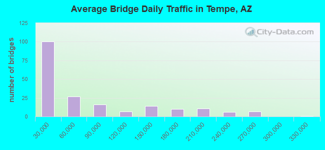
- 13,661,985Total average daily traffic
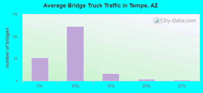
- 820,333Total average daily truck traffic
- National Bridge Inventory (NBI) Registered Bridges for Tempe
- No street view available for this location
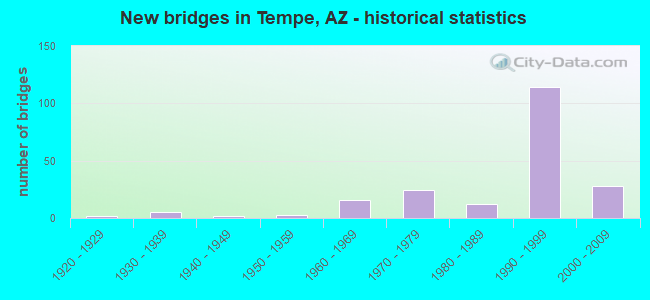
- New bridges - historical statistics
- 21920-1929
- 51930-1939
- 21940-1949
- 31950-1959
- 161960-1969
- 241970-1979
- 121980-1989
- 1141990-1999
- 282000-2009
- 12010-2019
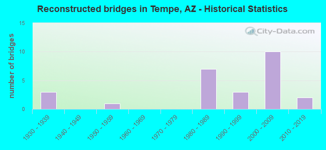
- Reconstructed bridges - Historical Statistics
- 31930-1939
- 01940-1949
- 11950-1959
- 01960-1969
- 01970-1979
- 71980-1989
- 31990-1999
- 102000-2009
- 22010-2019
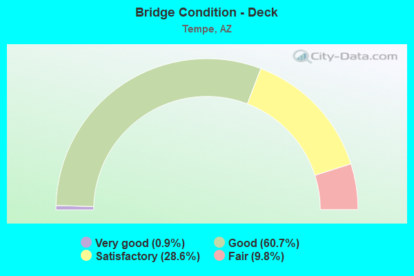
- Bridge Condition - Deck
- 0.9%Very good
- 60.7%Good
- 28.6%Satisfactory
- 9.8%Fair
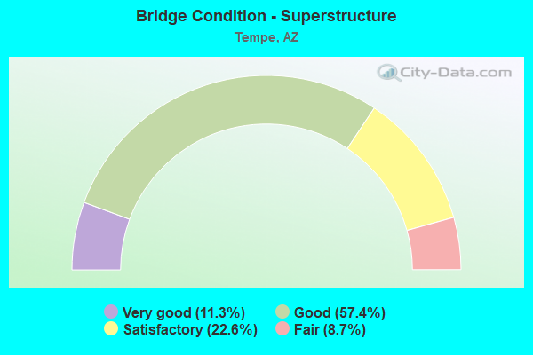
- Bridge Condition - Superstructure
- 11.3%Very good
- 57.4%Good
- 22.6%Satisfactory
- 8.7%Fair
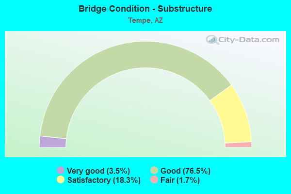
- Bridge Condition - Substructure
- 3.5%Very good
- 76.5%Good
- 18.3%Satisfactory
- 1.7%Fair
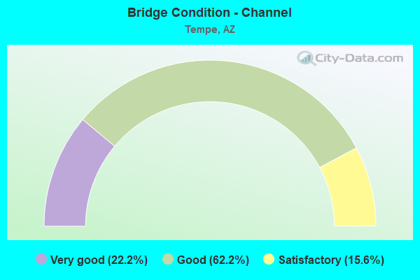
- Bridge Condition - Channel
- 22.2%Very good
- 62.2%Good
- 15.6%Satisfactory
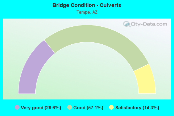
- Bridge Condition - Culverts
- 28.6%Very good
- 57.1%Good
- 14.3%Satisfactory
Find on map >> Show street view
Structure Number: 1378, Location: 1.4 E Jct I 10 (Lat: 33.385300, Lng: -111.943700), Route carried "under" structure: US 60, Year Built: 1969, Structure Length: 0. m, Average Daily Traffic: 194,472 (year 2018), Truck Traffic: 7%, Features Intersected: US 60, Facility Carried by Structure: Kyrene Rd
Minimum Vertical Clearance: 5.73m (18.80ft), Kilometerpoint: 279.092, Lanes on structure: 2, Lanes under structure: 2, Material/Design: Concrete continuous, Design/Construction: Box Beam or Girders - Single/Spread, Length of Maximum Span: 30.5m (100.1ft)
Find on map >> Show street view
Structure Number: 1393, Location: 1.65 mi E Jct I 10 (Lat: 33.385300, Lng: -111.939500), Route carried "under" structure: US 60, Year Built: 1970, Structure Length: 0. m, Average Daily Traffic: 194,472 (year 2018), Truck Traffic: 7%, Features Intersected: US 60, Facility Carried by Structure: Mill Ave
Minimum Vertical Clearance: 5.04m (16.54ft), Kilometerpoint: 279.463, Lanes on structure: 7, Lanes under structure: 10, Material/Design: Concrete continuous, Design/Construction: Box Beam or Girders - Single/Spread, Length of Maximum Span: 28.7m (94.2ft)
Find on map >> Show street view
Structure Number: 166, Location: 2.42 mi E Jct I 10 (Lat: 33.385300, Lng: -111.926500), Route carried "under" structure: US 60, Year Built: 1975, Structure Length: 0. m, Average Daily Traffic: 269,550 (year 2019), Truck Traffic: 7%, Features Intersected: US 60, Facility Carried by Structure: Rural Road
Minimum Vertical Clearance: 4.94m (16.21ft), Kilometerpoint: 280.702, Lanes on structure: 9, Lanes under structure: 10, Material/Design: Concrete continuous, Design/Construction: Box Beam or Girders - Single/Spread, Length of Maximum Span: 31.1m (102.0ft)
Find on map >> Show street view
Structure Number: 1661, Location: 3.42 mi E Jct I 10 (Lat: 33.385400, Lng: -111.909200), Route carried "under" structure: US 60, Year Built: 1975, Structure Length: 0. m, Average Daily Traffic: 269,550 (year 2019), Truck Traffic: 7%, Features Intersected: US 60, Facility Carried by Structure: McClintock Dr
Minimum Vertical Clearance: 4.94m (16.21ft), Kilometerpoint: 282.311, Lanes on structure: 9, Lanes under structure: 12, Material/Design: Concrete continuous, Design/Construction: Box Beam or Girders - Single/Spread, Length of Maximum Span: 31.1m (102.0ft)
Find on map >> Show street view
Structure Number: 1791, Location: 4.42 mi E Jct I 10 (Lat: 33.385400, Lng: -111.892400), Route carried "under" structure: US 60, Year Built: 1977, Structure Length: 0. m, Average Daily Traffic: 147,299 (year 2020), Truck Traffic: 7%, Features Intersected: US 60, Facility Carried by Structure: Price Road South
Minimum Vertical Clearance: 5.41m (17.75ft), Kilometerpoint: 283.856, Lanes on structure: 2, Lanes under structure: 2, Material/Design: Prestressed concrete continuous, Design/Construction: Box Beam or Girders - Single/Spread, Length of Maximum Span: 34.1m (111.9ft)
Find on map >> Show street view
Structure Number: 1792, Location: 4.49 mi E Jct I 10 (Lat: 33.385500, Lng: -111.891300), Route carried "under" structure: US 60, Year Built: 1977, Structure Length: 0. m, Average Daily Traffic: 147,299 (year 2020), Truck Traffic: 5%, Features Intersected: US 60, Facility Carried by Structure: SB L101
Minimum Vertical Clearance: 4.95m (16.24ft), Kilometerpoint: 283.969, Lanes on structure: 5, Lanes under structure: 5, Material/Design: Prestressed concrete continuous, Design/Construction: Box Beam or Girders - Single/Spread, Length of Maximum Span: 24.1m (79.1ft)
Find on map >> Show street view
Structure Number: 2005, Location: 0.7 mi North of Jct I 10 (Lat: 33.421700, Lng: -111.978100), Route carried "under" structure: City street , Year Built: 1984, Structure Length: 0. m, Average Daily Traffic: 32,093 (year 2018), Truck Traffic: 5%, Features Intersected: University Drive, Facility Carried by Structure: SR 143
Minimum Vertical Clearance: 5.33m (17.49ft), Kilometerpoint: 0.000, Lanes on structure: 4, Lanes under structure: 4, Material/Design: Prestressed concrete, Design/Construction: Box Beam or Girders - Single/Spread, Length of Maximum Span: 62.2m (204.1ft)
Find on map >> Show street view
Structure Number: 2041, Location: 0.33 mi N Jct US 60 (Lat: 33.418300, Lng: -111.891300), Route carried "under" structure: State highway 101, Year Built: 1988, Structure Length: 0. m, Average Daily Traffic: 125,560 (year 2019), Truck Traffic: 6%, Features Intersected: Loop 101, Facility Carried by Structure: Victory Drive
Minimum Vertical Clearance: 5.59m (18.34ft), Kilometerpoint: 84.973, Lanes on structure: 2, Lanes under structure: 2, Material/Design: Prestressed concrete continuous, Design/Construction: Box Beam or Girders - Single/Spread, Length of Maximum Span: 42.7m (140.1ft)
Find on map >> Show street view
Structure Number: 2042, Location: at Junction with US 60 (Lat: 33.414700, Lng: -111.891800), Route carried "under" structure: State highway 101, Year Built: 1988, Structure Length: 0. m, Average Daily Traffic: 253,344 (year 2018), Truck Traffic: 3%, Features Intersected: Loop 101, Facility Carried by Structure: Apache Blvd
Minimum Vertical Clearance: 5.61m (18.41ft), Kilometerpoint: 85.456, Lanes on structure: 3, Lanes under structure: 3, Material/Design: Prestressed concrete continuous, Design/Construction: Box Beam or Girders - Single/Spread, Length of Maximum Span: 35.1m (115.2ft)
Find on map >> Show street view
Structure Number: 2071, Location: 0.53 mi N of Jct US 60 (Lat: 33.422000, Lng: -111.891700), Route carried "under" structure: State highway 101, Year Built: 1990, Structure Length: 0. m, Average Daily Traffic: 125,560 (year 2019), Truck Traffic: 6%, Features Intersected: Loop 101, Facility Carried by Structure: University Drive
Minimum Vertical Clearance: 5.41m (17.75ft), Kilometerpoint: 84.651, Lanes on structure: 10, Lanes under structure: 10, Material/Design: Prestressed concrete continuous, Design/Construction: Box Beam or Girders - Single/Spread, Length of Maximum Span: 45.7m (149.9ft)
Find on map >> Show street view
Structure Number: 2072, Location: 1.8 mi N of Jct SR 360 (Lat: 33.411100, Lng: -111.891900), Route carried "under" structure: State highway 101, Year Built: 1990, Structure Length: 0. m, Average Daily Traffic: 253,344 (year 2019), Truck Traffic: 3%, Features Intersected: Loop 101, Facility Carried by Structure: SPRR
Minimum Vertical Clearance: 6.40m (21.00ft), Kilometerpoint: 85.810, Material/Design: Steel, Design/Construction: Stringer/Multi-beam, Length of Maximum Span: 50.3m (165.0ft)
Find on map >> Show street view
Structure Number: 2073, Location: 1.5 mi N of Jct SR 360 (Lat: 33.407500, Lng: -111.891700), Route carried "under" structure: State highway 101, Year Built: 1990, Structure Length: 0. m, Average Daily Traffic: 234,645 (year 2019), Truck Traffic: 4%, Features Intersected: Loop 101, Facility Carried by Structure: Broadway Road
Minimum Vertical Clearance: 5.44m (17.85ft), Kilometerpoint: 86.261, Lanes on structure: 10, Lanes under structure: 10, Material/Design: Prestressed concrete continuous, Design/Construction: Box Beam or Girders - Single/Spread, Length of Maximum Span: 42.7m (140.1ft)
Find on map >> Show street view
Structure Number: 2074, Location: 0.5 mi N of Jct US 60 (Lat: 33.392900, Lng: -111.891700), Route carried "under" structure: State highway 101, Year Built: 1990, Structure Length: 0. m, Average Daily Traffic: 234,645 (year 2019), Truck Traffic: 4%, Features Intersected: Loop 101, Facility Carried by Structure: Southern Ave
Minimum Vertical Clearance: 5.18m (16.99ft), Kilometerpoint: 87.017, Lanes on structure: 10, Lanes under structure: 10, Material/Design: Prestressed concrete continuous, Design/Construction: Box Beam or Girders - Single/Spread, Length of Maximum Span: 48.8m (160.1ft)
Find on map >> Show street view
Structure Number: 21, Location: Center of SR 101/US 60 TI (Lat: 33.385600, Lng: -111.890900), Route carried "under" structure: US 60, Year Built: 1998, Structure Length: 0. m, Average Daily Traffic: 147,299 (year 2020), Truck Traffic: 5%, Features Intersected: US 60, Facility Carried by Structure: SR 101L NB
Minimum Vertical Clearance: 6.59m (21.62ft), Kilometerpoint: 284.001, Lanes on structure: 4, Lanes under structure: 8, Material/Design: Prestressed concrete continuous, Design/Construction: Box Beam or Girders - Single/Spread, Length of Maximum Span: 24.1m (79.1ft)
Find on map >> Show street view
Structure Number: 2101, Location: 4.55 mi E Jct I 10 (Lat: 33.385400, Lng: -111.890100), Route carried "under" structure: US 60, Year Built: 1993, Structure Length: 0. m, Average Daily Traffic: 147,299 (year 2020), Truck Traffic: 5%, Features Intersected: US 60 EB & WB, Facility Carried by Structure: Price Road North
Minimum Vertical Clearance: 5.28m (17.32ft), Kilometerpoint: 284.065, Lanes on structure: 2, Lanes under structure: 2, Material/Design: Prestressed concrete continuous, Design/Construction: Box Beam or Girders - Single/Spread, Length of Maximum Span: 34.1m (111.9ft)
Find on map >> Show street view
Structure Number: 2102, Location: 11 mi E/I 10 - 0.4 S/60 (Lat: 33.378500, Lng: -111.893000), Route carried "under" structure: State highway 101, Year Built: 1997, Structure Length: 0. m, Average Daily Traffic: 125,717 (year 2019), Truck Traffic: 7%, Features Intersected: SR 101L, Facility Carried by Structure: Baseline Rd
Minimum Vertical Clearance: 6.11m (20.05ft), Kilometerpoint: 89.463, Lanes on structure: 12, Lanes under structure: 10, Material/Design: Prestressed concrete continuous, Design/Construction: Box Beam or Girders - Single/Spread, Length of Maximum Span: 35.7m (117.1ft)
Find on map >> Show street view
Structure Number: 2103, Location: 4.42 mi E Jct I17 & US 60 (Lat: 33.385300, Lng: -111.888500), Route carried "under" structure: US 60, Year Built: 1994, Structure Length: 0. m, Average Daily Traffic: 147,299 (year 2018), Truck Traffic: 5%, Features Intersected: US 60, L101, N Price Rd
Minimum Vertical Clearance: 6.86m (22.51ft), Kilometerpoint: 284.130, Lanes on structure: 2, Lanes under structure: 2, Material/Design: Prestressed concrete continuous, Design/Construction: Box Beam or Girders - Single/Spread, Length of Maximum Span: 70.1m (230.0ft)
Find on map >> Show street view
Structure Number: 2104, Location: SR 101/US 60 TI (Lat: 33.384600, Lng: -111.890500), Route carried "under" structure: US 60, Year Built: 1997, Structure Length: 0. m, Average Daily Traffic: 147,299 (year 2020), Truck Traffic: 7%, Features Intersected: NB/SB 101L &EB/WB US60, Facility Carried by Structure: Ramp S to W
Minimum Vertical Clearance: 5.67m (18.60ft), Kilometerpoint: 283.856, Lanes on structure: 2, Lanes under structure: 2, Material/Design: Prestressed concrete continuous, Design/Construction: Box Beam or Girders - Single/Spread, Length of Maximum Span: 54.6m (179.1ft)
Find on map >> Show street view
Structure Number: 2107, Location: SE Quadrant of 101/60 TI (Lat: 33.383800, Lng: -111.890400), Route carried "under" structure: ServiceState highway 101, Year Built: 1998, Structure Length: 0. m, Average Daily Traffic: 9,813 (year 2020), Truck Traffic: 7%, Features Intersected: East Frontage Road, Facility Carried by Structure: Ramp S to E
Minimum Vertical Clearance: 5.09m (16.70ft), Kilometerpoint: 88.675, Lanes on structure: 1, Lanes under structure: 2, Material/Design: Prestressed concrete continuous, Design/Construction: Box Beam or Girders - Single/Spread, Length of Maximum Span: 35.1m (115.2ft)
Find on map >> Show street view
Structure Number: 2108, Location: 4.42 E Jct I 10 & US 60 (Lat: 33.387000, Lng: -111.890100), Route carried "under" structure: Ramp US 60, Year Built: 1994, Structure Length: 0. m, Average Daily Traffic: 51,010 (year 2020), Truck Traffic: 7%, Features Intersected: Ramp E to S, Facility Carried by Structure: East Frontage Road
Minimum Vertical Clearance: 5.04m (16.54ft), Kilometerpoint: 283.856, Lanes on structure: 2, Lanes under structure: 3, Material/Design: Prestressed concrete continuous, Design/Construction: Box Beam or Girders - Single/Spread, Length of Maximum Span: 44.2m (145.0ft)
Find on map >> Show street view
Structure Number: 2109, Location: NE Quadrant of 101/60 TI (Lat: 33.386900, Lng: -111.892500), Route carried "under" structure: Ramp US 60, Year Built: 1997, Structure Length: 0. m, Average Daily Traffic: 12,457 (year 2020), Truck Traffic: 7%, Features Intersected: Ramp N to W, Facility Carried by Structure: W Frontage Rd
Minimum Vertical Clearance: 5.06m (16.60ft), Kilometerpoint: 283.856, Lanes on structure: 2, Lanes under structure: 1, Material/Design: Prestressed concrete continuous, Design/Construction: Box Beam or Girders - Single/Spread, Length of Maximum Span: 28.3m (92.8ft)
Find on map >> Show street view
Structure Number: 211, Location: SW Quadrant of 101/60 TI (Lat: 33.383900, Lng: -111.892500), Route carried "under" structure: Ramp US 60, Year Built: 2000, Structure Length: 0. m, Average Daily Traffic: 33,132 (year 2020), Truck Traffic: 7%, Features Intersected: Ramps W-S and W-N, Facility Carried by Structure: SR 101 W FR
Minimum Vertical Clearance: 5.47m (17.95ft), Kilometerpoint: 283.856, Lanes on structure: 2, Lanes under structure: 3, Material/Design: Prestressed concrete continuous, Design/Construction: Box Beam or Girders - Single/Spread, Length of Maximum Span: 40.5m (132.9ft)
Find on map >> Show street view
Structure Number: 2114, Location: US 60 and McClintock Dr (Lat: 33.385200, Lng: -111.908700), Route carried "under" structure: Ramp State highway 60, Year Built: 1998, Structure Length: 0. m, Average Daily Traffic: 20,090 (year 2019), Truck Traffic: 7%, Features Intersected: Ramp 60E to 101S, Facility Carried by Structure: Ramp D over Ramp E
Minimum Vertical Clearance: 5.13m (16.83ft), Kilometerpoint: 282.520, Lanes on structure: 1, Lanes under structure: 1, Material/Design: Concrete, Design/Construction: Frame, Length of Maximum Span: 11.9m (39.0ft)
Find on map >> Show street view
Structure Number: 2227, Location: 6.45 mi E Jct I 10 & (Lat: 33.435700, Lng: -111.949600), Route carried "under" structure: State highway 202, Year Built: 1993, Structure Length: 0. m, Average Daily Traffic: 224,918 (year 2019), Truck Traffic: 7%, Features Intersected: SL 202 (Red Mountain), Facility Carried by Structure: Center Parkway
Minimum Vertical Clearance: 7.31m (23.98ft), Kilometerpoint: 10.380, Lanes on structure: 4, Lanes under structure: 12, Material/Design: Prestressed concrete continuous, Design/Construction: Box Beam or Girders - Single/Spread, Length of Maximum Span: 42.7m (140.1ft)
Find on map >> Show street view
Structure Number: 2258, Location: 6.335 mi E Jct I 10 & (Lat: 33.435800, Lng: -111.944500), Route carried "under" structure: City street , Year Built: 1993, Structure Length: 0. m, Average Daily Traffic: 15,147 (year 2019), Truck Traffic: 2%, Features Intersected: Mill Ave & SPPR, Facility Carried by Structure: SR 202L
Minimum Vertical Clearance: 5.67m (18.60ft), Kilometerpoint: 0.000, Lanes on structure: 12, Lanes under structure: 6, Material/Design: Prestressed concrete continuous, Design/Construction: Box Beam or Girders - Multiple, Length of Maximum Span: 48.8m (160.1ft)
Find on map >> Show street view
Structure Number: 2261, Location: 7.55 mi E Jct I 10 & (Lat: 33.435800, Lng: -111.930700), Route carried "under" structure: City street , Year Built: 1993, Structure Length: 0. m, Average Daily Traffic: 6,000 (year 2016), Truck Traffic: 5%, Features Intersected: College Ave, Facility Carried by Structure: SR 202L
Minimum Vertical Clearance: 4.73m (15.52ft), Kilometerpoint: 0.000, Lanes on structure: 12, Lanes under structure: 12, Material/Design: Prestressed concrete, Design/Construction: Box Beam or Girders - Single/Spread, Length of Maximum Span: 37.2m (122.0ft)
Find on map >> Show street view
Structure Number: 2262, Location: 7.55 mi E Jct I 10 & (Lat: 33.436000, Lng: -111.930900), Route carried "under" structure: City street , Year Built: 1993, Structure Length: 0. m, Average Daily Traffic: 6,000 (year 2016), Truck Traffic: 5%, Features Intersected: College Avenue, Facility Carried by Structure: SR 202L Ramp
Minimum Vertical Clearance: 4.93m (16.17ft), Kilometerpoint: 0.000, Lanes on structure: 1, Lanes under structure: 2, Material/Design: Prestressed concrete, Design/Construction: Box Beam or Girders - Single/Spread, Length of Maximum Span: 37.8m (124.0ft)
Find on map >> Show street view
Structure Number: 2263, Location: 7.71 mi E Jct I 10 & (Lat: 33.436100, Lng: -111.926600), Route carried "under" structure: City street , Year Built: 1994, Structure Length: 0. m, Average Daily Traffic: 38,487 (year 2019), Truck Traffic: 8%, Features Intersected: Scottsdale Road, Facility Carried by Structure: SR 202L
Minimum Vertical Clearance: 5.41m (17.75ft), Kilometerpoint: 0.000, Lanes on structure: 11, Lanes under structure: 12, Material/Design: Prestressed concrete, Design/Construction: Box Beam or Girders - Multiple, Length of Maximum Span: 59.4m (194.9ft)
Find on map >> Show street view
Structure Number: 2265, Location: 8.06 mi E Jct I 10 & (Lat: 33.436100, Lng: -111.919700), Route carried "under" structure: City street , Year Built: 1994, Structure Length: 0. m, Average Daily Traffic: 2,000 (year 2020), Truck Traffic: 2%, Features Intersected: Indian Bend Wash, Facility Carried by Structure: SL 202 (Red Mtn)
Minimum Vertical Clearance: 5.03m (16.50ft), Kilometerpoint: 0.000, Lanes on structure: 14, Lanes under structure: 2, Material/Design: Prestressed concrete continuous, Design/Construction: Stringer/Multi-beam, Length of Maximum Span: 38.1m (125.0ft)
Find on map >> Show street view
Structure Number: 2268, Location: 1.5 mi N US60/McClintock (Lat: 33.435900, Lng: -111.912900), Route carried "under" structure: City street , Year Built: 1994, Structure Length: 0. m, Average Daily Traffic: 42,226 (year 2019), Truck Traffic: 12%, Features Intersected: McClintock; Salt Rv; Ram, Facility Carried by Structure: L 202 EB
Minimum Vertical Clearance: 5.19m (17.03ft), Kilometerpoint: 0.000, Lanes on structure: 7, Lanes under structure: 7, Material/Design: Prestressed concrete continuous, Design/Construction: Stringer/Multi-beam, Length of Maximum Span: 42.7m (140.1ft)
Find on map >> Show street view
Structure Number: 2269, Location: 1.5 mi W US60/McClintock (Lat: 33.436200, Lng: -111.912300), Route carried "under" structure: City street , Year Built: 1994, Structure Length: 0. m, Average Daily Traffic: 42,226 (year 2019), Truck Traffic: 12%, Features Intersected: McClintock; Salt Rv; Ram, Facility Carried by Structure: L 202 WB
Minimum Vertical Clearance: 5.68m (18.64ft), Kilometerpoint: 0.000, Lanes on structure: 6, Lanes under structure: 7, Material/Design: Prestressed concrete continuous, Design/Construction: Stringer/Multi-beam, Length of Maximum Span: 42.7m (140.1ft)
Find on map >> Show street view
Structure Number: 2283, Location: 4.5 mi E/I 10, 1.5 S/60 (Lat: 33.363900, Lng: -111.894500), Route carried "under" structure: State highway 101, Year Built: 1999, Structure Length: 0. m, Average Daily Traffic: 205,392 (year 2019), Truck Traffic: 7%, Features Intersected: SR 101L, Facility Carried by Structure: Guadalupe Road
Minimum Vertical Clearance: 5.24m (17.19ft), Kilometerpoint: 91.089, Lanes on structure: 8, Lanes under structure: 8, Material/Design: Prestressed concrete continuous, Design/Construction: Box Beam or Girders - Single/Spread, Length of Maximum Span: 27.7m (90.9ft)
Find on map >> Show street view
Structure Number: 2286, Location: 0.45 S of Elliot Rd (Lat: 33.343000, Lng: -111.893800), Route carried "under" structure: State highway 101, Year Built: 1999, Structure Length: 0. m, Average Daily Traffic: 186,471 (year 2017), Truck Traffic: 6%, Features Intersected: SR 101L, Facility Carried by Structure: Conference Drive
Minimum Vertical Clearance: 5.63m (18.47ft), Kilometerpoint: 93.471, Lanes on structure: 2, Lanes under structure: 2, Material/Design: Prestressed concrete continuous, Design/Construction: Box Beam or Girders - Single/Spread, Length of Maximum Span: 31.4m (103.0ft)
Find on map >> Show street view
Structure Number: 2287, Location: 3.5 mi S of 60 (Lat: 33.334900, Lng: -111.893300), Route carried "under" structure: State highway 101, Year Built: 1999, Structure Length: 0. m, Average Daily Traffic: 186,471 (year 2019), Truck Traffic: 6%, Features Intersected: SR 101L, Facility Carried by Structure: Warner Road
Minimum Vertical Clearance: 5.24m (17.19ft), Kilometerpoint: 94.308, Lanes on structure: 10, Lanes under structure: 10, Material/Design: Prestressed concrete continuous, Design/Construction: Box Beam or Girders - Single/Spread, Length of Maximum Span: 32.0m (105.0ft)
Find on map >> Show street view
Structure Number: 2305, Location: at Superstition TI (Lat: 33.393061, Lng: -111.968400), Route carried "under" structure: City street , Year Built: 1995, Structure Length: 0. m, Average Daily Traffic: 25,595 (year 2018), Truck Traffic: 3%, Features Intersected: Southern Avenue, Facility Carried by Structure: Ramp S-E
Minimum Vertical Clearance: 5.05m (16.57ft), Kilometerpoint: 0.000, Lanes on structure: 3, Lanes under structure: 5, Material/Design: Prestressed concrete, Design/Construction: Stringer/Multi-beam, Length of Maximum Span: 40.5m (132.9ft)
Find on map >> Show street view
Structure Number: 2306, Location: 2.8 mi S of Jct US 60 (Lat: 33.349100, Lng: -111.972700), Route carried "under" structure: Interstate 10, Year Built: 1992, Structure Length: 0. m, Average Daily Traffic: 213,737 (year 2017), Truck Traffic: 4%, Features Intersected: I 10, Facility Carried by Structure: Elliot Road
Minimum Vertical Clearance: 5.03m (16.50ft), Kilometerpoint: 253.777, Lanes on structure: 10, Lanes under structure: 8, Material/Design: Prestressed concrete continuous, Design/Construction: Stringer/Multi-beam, Length of Maximum Span: 39.9m (130.9ft)
Find on map >> Show street view
Structure Number: 233, Location: 1.6 mi E junction I-10 (Lat: 33.291800, Lng: -111.945600), Route carried "under" structure: State highway 202, Year Built: 2003, Structure Length: 0. m, Average Daily Traffic: 80,456 (year 2018), Truck Traffic: 5%, Features Intersected: L 202, Facility Carried by Structure: Kyrene Rd
Minimum Vertical Clearance: 5.45m (17.88ft), Kilometerpoint: 86.502, Lanes on structure: 6, Lanes under structure: 6, Material/Design: Prestressed concrete continuous, Design/Construction: Box Beam or Girders - Single/Spread, Length of Maximum Span: 40.5m (132.9ft)
Find on map >> Show street view
Structure Number: 2331, Location: 3.6 mi E junction I-10 (Lat: 33.291300, Lng: -111.911200), Route carried "under" structure: State highway 202, Year Built: 2003, Structure Length: 0. m, Average Daily Traffic: 80,400 (year 2018), Truck Traffic: 7%, Features Intersected: L 202, Facility Carried by Structure: McClintock Drive
Minimum Vertical Clearance: 5.48m (17.98ft), Kilometerpoint: 83.251, Lanes on structure: 5, Lanes under structure: 5, Material/Design: Prestressed concrete continuous, Design/Construction: Box Beam or Girders - Multiple, Length of Maximum Span: 41.8m (137.1ft)
Find on map >> Show street view
Structure Number: 2341, Location: SR 101 / SR 202 TI (Lat: 33.436100, Lng: -111.890800), Route carried "under" structure: Ramp State highway 101, Year Built: 1999, Structure Length: 0. m, Average Daily Traffic: 10,344 (year 2017), Truck Traffic: 7%, Features Intersected: Salt River & Ramp W-S
Minimum Vertical Clearance: 6.18m (20.28ft), Kilometerpoint: 81.883, Lanes on structure: 5, Lanes under structure: 1, Material/Design: Prestressed concrete continuous, Design/Construction: Stringer/Multi-beam, Length of Maximum Span: 42.7m (140.1ft)
Find on map >> Show street view
Structure Number: 2342, Location: SR 101 / SR 202 TI (Lat: 33.436100, Lng: -111.891100), Route carried "under" structure: Ramp State highway 101, Year Built: 1997, Structure Length: 0. m, Average Daily Traffic: 10,344 (year 2017), Truck Traffic: 7%, Features Intersected: Salt River & Ramp W-S
Minimum Vertical Clearance: 5.49m (18.01ft), Kilometerpoint: 81.883, Lanes on structure: 5, Lanes under structure: 1, Material/Design: Prestressed concrete continuous, Design/Construction: Stringer/Multi-beam, Length of Maximum Span: 42.7m (140.1ft)
Find on map >> Show street view
Structure Number: 2347, Location: at Superstition TI (Lat: 33.389250, Lng: -111.969000), Route carried "under" structure: Interstate 10, Year Built: 1995, Structure Length: 0. m, Average Daily Traffic: 124,147 (year 2017), Truck Traffic: 4%, Features Intersected: I 10, Facility Carried by Structure: Ramp S-E
Minimum Vertical Clearance: 5.46m (17.91ft), Kilometerpoint: 249.995, Lanes on structure: 3, Lanes under structure: 9, Material/Design: Prestressed concrete continuous, Design/Construction: Box Beam or Girders - Single/Spread, Length of Maximum Span: 45.7m (149.9ft)
Find on map >> Show street view
Structure Number: 2348, Location: 0.7 mi S Jct US 60 (Lat: 33.378461, Lng: -111.967600), Route carried "under" structure: City street , Year Built: 1995, Structure Length: 0. m, Average Daily Traffic: 65,200 (year 2015), Truck Traffic: 3%, Features Intersected: Baseline Road, Facility Carried by Structure: Ramp WB C-D
Minimum Vertical Clearance: 5.85m (19.19ft), Kilometerpoint: 0.000, Lanes on structure: 2, Lanes under structure: 10, Material/Design: Prestressed concrete, Design/Construction: Box Beam or Girders - Single/Spread, Length of Maximum Span: 44.8m (147.0ft)
Find on map >> Show street view
Structure Number: 2349, Location: 0.7 mi S Jct US 60 (Lat: 33.378461, Lng: -111.968000), Route carried "under" structure: City street , Year Built: 1994, Structure Length: 0. m, Average Daily Traffic: 65,200 (year 2015), Truck Traffic: 3%, Features Intersected: Baseline Road, Facility Carried by Structure: I 10
Minimum Vertical Clearance: 5.65m (18.54ft), Kilometerpoint: 0.000, Lanes on structure: 9, Lanes under structure: 10, Material/Design: Prestressed concrete, Design/Construction: Box Beam or Girders - Single/Spread, Length of Maximum Span: 44.8m (147.0ft)
Find on map >> Show street view
Structure Number: 235, Location: 0.37 mi E Jct I 10 (Lat: 33.387300, Lng: -111.961100), Route carried "under" structure: City street , Year Built: 1995, Structure Length: 0. m, Average Daily Traffic: 28,297 (year 2019), Truck Traffic: 2%, Features Intersected: Priest Drive, Facility Carried by Structure: US 60 EB
Minimum Vertical Clearance: 5.72m (18.77ft), Kilometerpoint: 0.000, Lanes on structure: 6, Lanes under structure: 8, Material/Design: Prestressed concrete, Design/Construction: Stringer/Multi-beam, Length of Maximum Span: 39.0m (128.0ft)
Find on map >> Show street view
Structure Number: 2351, Location: 0.37 mi E Jct I 10 (Lat: 33.387600, Lng: -111.961100), Route carried "under" structure: City street , Year Built: 1995, Structure Length: 0. m, Average Daily Traffic: 28,297 (year 2018), Truck Traffic: 2%, Features Intersected: Priest Drive, Facility Carried by Structure: US 60 WB and Ramps
Minimum Vertical Clearance: 5.68m (18.64ft), Kilometerpoint: 0.000, Lanes on structure: 5, Lanes under structure: 8, Material/Design: Prestressed concrete, Design/Construction: Stringer/Multi-beam, Length of Maximum Span: 39.0m (128.0ft)
Find on map >> Show street view
Structure Number: 2357, Location: 0.33 mi S Jct SL 202 (Lat: 33.429100, Lng: -111.891100), Route carried "under" structure: City street , Year Built: 1995, Structure Length: 0. m, Average Daily Traffic: 31,439 (year 2021), Truck Traffic: 5%, Features Intersected: Rio Salado Parkway, Facility Carried by Structure: SL 101
Minimum Vertical Clearance: 5.65m (18.54ft), Kilometerpoint: 0.000, Lanes on structure: 8, Lanes under structure: 6, Material/Design: Prestressed concrete, Design/Construction: Box Beam or Girders - Single/Spread, Length of Maximum Span: 50.0m (164.0ft)
Find on map >> Show street view
Structure Number: 2358, Location: at Jct SL 101 & 202 (Lat: 33.429100, Lng: -111.890500), Route carried "under" structure: State highway 101, Year Built: 1995, Structure Length: 0. m, Average Daily Traffic: 105,736 (year 2017), Truck Traffic: 7%, Features Intersected: Rio Salado Pkwy; Pima Fw
Minimum Vertical Clearance: 6.83m (22.41ft), Kilometerpoint: 82.077, Lanes on structure: 2, Lanes under structure: 11, Material/Design: Prestressed concrete continuous, Design/Construction: Box Beam or Girders - Single/Spread, Length of Maximum Span: 65.8m (215.9ft)
Find on map >> Show street view
Structure Number: 2359, Location: Price Road Freeway (Lat: 33.429400, Lng: -111.891600), Route carried "under" structure: City street , Year Built: 1994, Structure Length: 0. m, Average Daily Traffic: 31,439 (year 2021), Truck Traffic: 5%, Features Intersected: Rio Salado Parkway, Facility Carried by Structure: L101 Ramp E/W - S
Minimum Vertical Clearance: 5.20m (17.06ft), Kilometerpoint: 0.000, Lanes on structure: 3, Lanes under structure: 6, Material/Design: Prestressed concrete continuous, Design/Construction: Box Beam or Girders - Single/Spread, Length of Maximum Span: 70.1m (230.0ft)
Find on map >> Show street view
Structure Number: 2368, Location: at Superstition TI (Lat: 33.387700, Lng: -111.962300), Route carried "under" structure: Interstate 10, Year Built: 1995, Structure Length: 0. m, Average Daily Traffic: 150,865 (year 2015), Truck Traffic: 8%, Features Intersected: I 10; Ramp S-E
Minimum Vertical Clearance: 7.35m (24.11ft), Kilometerpoint: 250.092, Lanes on structure: 1, Lanes under structure: 14, Material/Design: Prestressed concrete continuous, Design/Construction: Box Beam or Girders - Single/Spread, Length of Maximum Span: 54.9m (180.1ft)
Find on map >> Show street view
Structure Number: 2375, Location: SW Quadrant of 101/202 TI (Lat: 33.432000, Lng: -111.891500), Route carried "under" structure: Ramp State highway 202, Year Built: 1995, Structure Length: 0. m, Average Daily Traffic: 19,592 (year 2021), Truck Traffic: 7%, Features Intersected: Ramp 202E to 101N, Facility Carried by Structure: SR 101 SB Ramp
Minimum Vertical Clearance: 5.52m (18.11ft), Kilometerpoint: 16.898, Lanes on structure: 1, Lanes under structure: 1, Material/Design: Prestressed concrete, Design/Construction: Box Beam or Girders - Single/Spread, Length of Maximum Span: 33.5m (109.9ft)
Find on map >> Show street view
Structure Number: 2376, Location: S Half of 101/202 TI (Lat: 33.431900, Lng: -111.890900), Route carried "under" structure: Ramp State highway 202, Year Built: 1999, Structure Length: 0. m, Average Daily Traffic: 19,592 (year 2021), Truck Traffic: 7%, Features Intersected: L101/L202 Ramp E-N, Facility Carried by Structure: SR 101L NB
Minimum Vertical Clearance: 6.90m (22.64ft), Kilometerpoint: 15.772, Lanes on structure: 4, Lanes under structure: 4, Material/Design: Prestressed concrete, Design/Construction: Box Beam or Girders - Single/Spread, Length of Maximum Span: 36.6m (120.1ft)
Find on map >> Show street view
Structure Number: 2377, Location: S Half of L101/L202 TI (Lat: 33.431900, Lng: -111.891200), Route carried "under" structure: Ramp State highway 202, Year Built: 1995, Structure Length: 0. m, Average Daily Traffic: 19,592 (year 2021), Truck Traffic: 7%, Features Intersected: L101/L202 Ramp E-N, Facility Carried by Structure: SR 101L SB
Minimum Vertical Clearance: 7.42m (24.34ft), Kilometerpoint: 15.772, Lanes on structure: 4, Lanes under structure: 4, Material/Design: Prestressed concrete, Design/Construction: Box Beam or Girders - Single/Spread, Length of Maximum Span: 36.6m (120.1ft)
Find on map >> Show street view
Structure Number: 2378, Location: S Half of L101/L202 TI (Lat: 33.432000, Lng: -111.890600), Route carried "under" structure: Ramp State highway 202, Year Built: 1995, Structure Length: 0. m, Average Daily Traffic: 19,592 (year 2018), Truck Traffic: 7%, Features Intersected: L101/L202 Ramp E-N, Facility Carried by Structure: SR 101L Ramp NB
Minimum Vertical Clearance: 5.81m (19.06ft), Kilometerpoint: 16.898, Lanes on structure: 1, Lanes under structure: 1, Material/Design: Prestressed concrete, Design/Construction: Box Beam or Girders - Single/Spread, Length of Maximum Span: 33.5m (109.9ft)
Find on map >> Show street view
Structure Number: 2379, Location: at Jct SL 101 & SL 202 (Lat: 33.434900, Lng: -111.892900), Route carried "under" structure: State highway 202, Year Built: 1995, Structure Length: 0. m, Average Daily Traffic: 164,672 (year 2017), Truck Traffic: 7%, Features Intersected: SL 202, Facility Carried by Structure: Ramp W-S; SL 101
Minimum Vertical Clearance: 6.20m (20.34ft), Kilometerpoint: 15.933, Lanes on structure: 1, Lanes under structure: 8, Material/Design: Prestressed concrete continuous, Design/Construction: Box Beam or Girders - Single/Spread, Length of Maximum Span: 36.6m (120.1ft)
Find on map >> Show street view
Structure Number: 2381, Location: SR 101/202 Interchange (Lat: 33.433700, Lng: -111.890800), Route carried "under" structure: State highway 202, Year Built: 1997, Structure Length: 0. m, Average Daily Traffic: 164,672 (year 2017), Truck Traffic: 7%, Features Intersected: SR 202L, Facility Carried by Structure: SR 101L
Minimum Vertical Clearance: 7.56m (24.80ft), Kilometerpoint: 16.898, Lanes on structure: 5, Lanes under structure: 5, Material/Design: Prestressed concrete continuous, Design/Construction: Box Beam or Girders - Single/Spread, Length of Maximum Span: 42.1m (138.1ft)
Find on map >> Show street view
Structure Number: 2382, Location: 101/202 Interchange (Lat: 33.433800, Lng: -111.891200), Route carried "under" structure: State highway 202, Year Built: 1997, Structure Length: 0. m, Average Daily Traffic: 164,672 (year 2017), Truck Traffic: 7%, Features Intersected: SR 202, Facility Carried by Structure: SR 101 SB
Minimum Vertical Clearance: 7.18m (23.56ft), Kilometerpoint: 16.898, Lanes on structure: 6, Lanes under structure: 6, Material/Design: Prestressed concrete continuous, Design/Construction: Box Beam or Girders - Single/Spread, Length of Maximum Span: 42.1m (138.1ft)
Find on map >> Show street view
Structure Number: 2383, Location: SW Quadrant 101/202 TI (Lat: 33.433100, Lng: -111.892800), Route carried "under" structure: Ramp State highway 101, Year Built: 1997, Structure Length: 0. m, Average Daily Traffic: 19,592 (year 2017), Truck Traffic: 7%, Features Intersected: Ramp Under 202E to 101N
Minimum Vertical Clearance: 7.67m (25.16ft), Kilometerpoint: 82.688, Lanes on structure: 1, Lanes under structure: 1, Material/Design: Prestressed concrete continuous, Design/Construction: Box Beam or Girders - Single/Spread, Length of Maximum Span: 47.2m (154.9ft)
Find on map >> Show street view
Structure Number: 2405, Location: 5.7 mi E Jct I 10 & S (Lat: 33.437300, Lng: -111.960900), Route carried "under" structure: State highway 202, Year Built: 1991, Structure Length: 0. m, Average Daily Traffic: 198,030 (year 2017), Truck Traffic: 7%, Features Intersected: Red Mt Fwy (Loop 202), Facility Carried by Structure: Priest Drive
Minimum Vertical Clearance: 7.22m (23.69ft), Kilometerpoint: 9.173, Lanes on structure: 10, Lanes under structure: 12, Material/Design: Prestressed concrete continuous, Design/Construction: Stringer/Multi-beam, Length of Maximum Span: 40.8m (133.9ft)
Find on map >> Show street view
Structure Number: 2486, Location: S Quadrant of 101/60 TI (Lat: 33.383500, Lng: -111.891200), Route carried "under" structure: Ramp US 60, Year Built: 1999, Structure Length: 0. m, Average Daily Traffic: 13,614 (year 2020), Truck Traffic: 7%, Features Intersected: Ramp W to N, Facility Carried by Structure: NB 101L
Minimum Vertical Clearance: 5.31m (17.42ft), Kilometerpoint: 283.856, Lanes on structure: 4, Lanes under structure: 1, Material/Design: Prestressed concrete continuous, Design/Construction: Box Beam or Girders - Single/Spread, Length of Maximum Span: 23.2m (76.1ft)
Find on map >> Show street view
Structure Number: 2487, Location: S Quad of US 60/ SR 101 T (Lat: 33.383500, Lng: -111.891500), Route carried "under" structure: Ramp US 60, Year Built: 1997, Structure Length: 0. m, Average Daily Traffic: 13,614 (year 2020), Truck Traffic: 5%, Features Intersected: Ramp W to N, Facility Carried by Structure: SR 101L SB
Minimum Vertical Clearance: 6.16m (20.21ft), Kilometerpoint: 283.856, Lanes on structure: 4, Lanes under structure: 1, Material/Design: Prestressed concrete continuous, Design/Construction: Box Beam or Girders - Single/Spread, Length of Maximum Span: 23.2m (76.1ft)
Find on map >> Show street view
Structure Number: 2488, Location: N Quadrant of 60/101 TI (Lat: 33.387900, Lng: -111.891000), Route carried "under" structure: Ramp US 60, Year Built: 1998, Structure Length: 0. m, Average Daily Traffic: 15,274 (year 2020), Truck Traffic: 5%, Features Intersected: Ramp E to S, Facility Carried by Structure: SR 101 NB
Minimum Vertical Clearance: 5.68m (18.64ft), Kilometerpoint: 283.856, Lanes on structure: 5, Lanes under structure: 1, Material/Design: Prestressed concrete continuous, Design/Construction: Box Beam or Girders - Single/Spread, Length of Maximum Span: 21.3m (69.9ft)
Find on map >> Show street view
Structure Number: 2489, Location: N Quadrant 60/101 TI (Lat: 33.387900, Lng: -111.891300), Route carried "under" structure: Ramp US 60, Year Built: 2000, Structure Length: 0. m, Average Daily Traffic: 15,274 (year 2020), Truck Traffic: 5%, Features Intersected: Ramp E to S, Facility Carried by Structure: SR 101 SB
Minimum Vertical Clearance: 5.32m (17.45ft), Kilometerpoint: 283.856, Lanes on structure: 4, Lanes under structure: 1, Material/Design: Prestressed concrete continuous, Design/Construction: Box Beam or Girders - Single/Spread, Length of Maximum Span: 19.8m (65.0ft)
Find on map >> Show street view
Structure Number: 264, Location: 2.42 mi E Jct I 10 (Lat: 33.385300, Lng: -111.926700), Route carried "under" structure: US 60, Year Built: 2002, Structure Length: 0. m, Average Daily Traffic: 207,968 (year 2018), Truck Traffic: 7%, Features Intersected: US 60, Facility Carried by Structure: Ped Bridge
Minimum Vertical Clearance: 6.33m (20.77ft), Kilometerpoint: 280.686, Lanes under structure: 10, Material/Design: Prestressed concrete continuous, Design/Construction: Segmental Box Girder, Length of Maximum Span: 36.0m (118.1ft)
Find on map >> Show street view
Structure Number: 2641, Location: 3.42 mi E Jct I 10 (Lat: 33.385400, Lng: -111.908900), Route carried "under" structure: US 60, Year Built: 2002, Structure Length: 0. m, Average Daily Traffic: 173,878 (year 2018), Truck Traffic: 7%, Features Intersected: US 60, Facility Carried by Structure: Ped Bridge
Minimum Vertical Clearance: 5.78m (18.96ft), Kilometerpoint: 282.311, Lanes under structure: 12, Material/Design: Prestressed concrete continuous, Design/Construction: Segmental Box Girder, Length of Maximum Span: 36.0m (118.1ft)
Find on map >> Show street view
Structure Number: 27, Location: I-10 and US 60 Jct (Lat: 33.391139, Lng: -111.967600), Route carried "under" structure: Interstate 10, Year Built: 2002, Structure Length: 0. m, Average Daily Traffic: 149,898 (year 2017), Truck Traffic: 4%, Features Intersected: I-10 WB
Minimum Vertical Clearance: 6.49m (21.29ft), Kilometerpoint: 249.883, Lanes on structure: 2, Lanes under structure: 4, Material/Design: Prestressed concrete continuous, Design/Construction: Stringer/Multi-beam, Length of Maximum Span: 33.5m (109.9ft)
Find on map >> Show street view
Structure Number: 2701, Location: 1.98 m E Jct I 10 (Lat: 33.385400, Lng: -111.934100), Route carried "under" structure: US 60, Year Built: 2002, Structure Length: 0. m, Average Daily Traffic: 207,968 (year 2018), Truck Traffic: 7%, Features Intersected: US 60, Facility Carried by Structure: College Av Ped
Minimum Vertical Clearance: 5.61m (18.41ft), Kilometerpoint: 280.110, Lanes under structure: 12, Material/Design: Steel, Design/Construction: Truss - Thru, Length of Maximum Span: 61.0m (200.1ft)
Find on map >> Show street view
Structure Number: 2702, Location: 0.3 mi W Jct US 60 (Lat: 33.393069, Lng: -111.967600), Route carried "under" structure: City street , Year Built: 2002, Structure Length: 0. m, Average Daily Traffic: 28,700 (year 2019), Truck Traffic: 3%, Features Intersected: Southern Avenue, Facility Carried by Structure: I 10
Minimum Vertical Clearance: 8.18m (26.84ft), Kilometerpoint: 0.000, Lanes on structure: 2, Lanes under structure: 7, Material/Design: Prestressed concrete, Design/Construction: Box Beam or Girders - Multiple, Length of Maximum Span: 26.5m (86.9ft)
Find on map >> Show street view
Structure Number: 2716, Location: 0.7 mi S Chandler blvrd (Lat: 33.296539, Lng: -111.972500), Route carried "under" structure: State highway 202, Year Built: 2003, Structure Length: 0. m, Average Daily Traffic: 48,632 (year 2017), Truck Traffic: 7%, Features Intersected: 202L, Facility Carried by Structure: I-10 EB
Minimum Vertical Clearance: 6.64m (21.78ft), Kilometerpoint: 89.077, Lanes on structure: 5, Lanes under structure: 5, Material/Design: Prestressed concrete continuous, Design/Construction: Box Beam or Girders - Single/Spread, Length of Maximum Span: 43.9m (144.0ft)
Find on map >> Show street view
Structure Number: 2751, Location: 0.5mi E MclintocRd & US60 (Lat: 33.385300, Lng: -111.900700), Route carried "under" structure: US 60, Year Built: 2004, Structure Length: 0. m, Average Daily Traffic: 173,878 (year 2018), Truck Traffic: 7%, Features Intersected: US 60, Facility Carried by Structure: Country Club Way
Minimum Vertical Clearance: 5.92m (19.42ft), Kilometerpoint: 283.100, Lanes under structure: 15, Material/Design: Steel continuous, Design/Construction: Truss - Thru, Length of Maximum Span: 49.1m (161.1ft)
Find on map >> Show street view
Structure Number: 2777, Location: 0.3 mi W Jct US 60 (Lat: 33.393058, Lng: -111.967378), Route carried "under" structure: City street , Year Built: 1966, Structure Length: 0. m, Average Daily Traffic: 28,700 (year 2015), Truck Traffic: 3%, Features Intersected: Southern Avenue, Facility Carried by Structure: I 10; WB
Minimum Vertical Clearance: 4.77m (15.65ft), Kilometerpoint: 0.000, Lanes on structure: 7, Lanes under structure: 7, Material/Design: Concrete, Design/Construction: Box Beam or Girders - Single/Spread, Length of Maximum Span: 26.5m (86.9ft)
Find on map >> Show street view
Structure Number: 2811, Location: at Junction with L 101 (Lat: 33.414900, Lng: -111.890800), Route carried "under" structure: State highway 101, Year Built: 1988, Structure Length: 0. m, Average Daily Traffic: 253,344 (year 2019), Truck Traffic: 3%, Features Intersected: Loop 101, Facility Carried by Structure: Apache Blvd
Minimum Vertical Clearance: 5.73m (18.80ft), Kilometerpoint: 85.456, Lanes on structure: 3, Lanes under structure: 3, Material/Design: Prestressed concrete continuous, Design/Construction: Box Beam or Girders - Single/Spread, Length of Maximum Span: 35.1m (115.2ft)
Find on map >> Show street view
Structure Number: 2813, Location: at Junction with L101 (Lat: 33.414944, Lng: -111.891361), Route carried "under" structure: State highway 101, Year Built: 2008, Structure Length: 0. m, Average Daily Traffic: 253,344 (year 2019), Truck Traffic: 3%, Features Intersected: Loop 101, Facility Carried by Structure: Pedestrian
Minimum Vertical Clearance: 5.68m (18.64ft), Kilometerpoint: 85.456, Material/Design: Prestressed concrete continuous, Design/Construction: Box Beam or Girders - Single/Spread, Length of Maximum Span: 35.1m (115.2ft)
Find on map >> Show street view
Structure Number: 2814, Location: at Junction with L 101 (Lat: 33.414639, Lng: -111.891361), Route carried "under" structure: State highway 101, Year Built: 2008, Structure Length: 0. m, Average Daily Traffic: 253,344 (year 2019), Truck Traffic: 3%, Features Intersected: Loop 101, Facility Carried by Structure: Pedestrian
Minimum Vertical Clearance: 5.56m (18.24ft), Kilometerpoint: 85.456, Material/Design: Prestressed concrete continuous, Design/Construction: Box Beam or Girders - Single/Spread, Length of Maximum Span: 35.1m (115.2ft)
Find on map >> Show street view
Structure Number: 7817, Location: 0.2 mi S of Curry Rd (Lat: 33.431300, Lng: -111.940000), Route carried "under" structure: City street , Year Built: 1994, Structure Length: 0. m, Average Daily Traffic: 12,820 (year 2021), Truck Traffic: 5%, Features Intersected: Salt Rvr, Rio Salado Pkw, Facility Carried by Structure: Mill Avenue NB
Minimum Vertical Clearance: 4.12m (13.52ft), Kilometerpoint: 0.000, Lanes on structure: 2, Lanes under structure: 2, Material/Design: Prestressed concrete continuous, Design/Construction: Box Beam or Girders - Single/Spread, Length of Maximum Span: 45.7m (149.9ft)
Find on map >> Show street view
Structure Number: 7996, Location: 0.1 mi S of Curry Road (Lat: 33.435400, Lng: -111.941700), Route carried "under" structure: City street , Year Built: 1994, Structure Length: 0. m, Average Daily Traffic: 600 (year 2016), Truck Traffic: 1%, Features Intersected: North Bank Access Rd, Facility Carried by Structure: Mill Avenue NB
Minimum Vertical Clearance: 4.86m (15.94ft), Kilometerpoint: 0.000, Lanes on structure: 2, Lanes under structure: 2, Material/Design: Concrete, Design/Construction: Frame, Length of Maximum Span: 21.0m (68.9ft)
Find on map >> Show street view
Structure Number: 9372, Location: 0.3 mi N of Broadway (Lat: 33.411100, Lng: -111.940000), Route carried "under" structure: City street , Year Built: 1975, Structure Length: 0. m, Average Daily Traffic: 12,479 (year 2019), Truck Traffic: 5%, Features Intersected: Mill Avenue, Facility Carried by Structure: Southern Pacific
Minimum Vertical Clearance: 4.73m (15.52ft), Kilometerpoint: 0.000, Lanes under structure: 4, Material/Design: Prestressed concrete, Design/Construction: Box Beam or Girders - Multiple, Length of Maximum Span: 13.7m (44.9ft)
Find on map >> Show street view
Structure Number: 9373, Location: 0.3 mi S Apache Blvd (Lat: 33.411000, Lng: -111.909300), Route carried "under" structure: City street , Year Built: 1972, Structure Length: 0. m, Average Daily Traffic: 16,753 (year 2019), Truck Traffic: 5%, Features Intersected: McClintock Drive, Facility Carried by Structure: SPRR
Minimum Vertical Clearance: 4.82m (15.81ft), Kilometerpoint: 0.000, Material/Design: Prestressed concrete, Design/Construction: Box Beam or Girders - Multiple, Length of Maximum Span: 13.1m (43.0ft)
Find on map >> Show street view
Structure Number: 9385, Location: 0.37 mi W of Rural Rd (Lat: 33.425000, Lng: -111.933333), Route carried "under" structure: City street , Year Built: 1964, Structure Length: 0. m, Average Daily Traffic: 26,482 (year 2019), Truck Traffic: 10%, Features Intersected: University Drive, Facility Carried by Structure: Palm Walk
Minimum Vertical Clearance: 5.39m (17.68ft), Kilometerpoint: 0.000, Lanes under structure: 4, Material/Design: Prestressed concrete, Design/Construction: Arch - Thru, Length of Maximum Span: 31.7m (104.0ft)
Find on map >> Show street view
Structure Number: 9952, Location: 0.6 mi N of Curry Road (Lat: 33.443100, Lng: -111.948200), Route carried "under" structure: City street , Year Built: 1953, Structure Length: 0. m, Average Daily Traffic: 6,066 (year 2019), Truck Traffic: 1%, Features Intersected: Mill Ave, Facility Carried by Structure: Center Pkwy OP WB
Minimum Vertical Clearance: 4.54m (14.90ft), Kilometerpoint: 0.000, Lanes on structure: 1, Lanes under structure: 2, Material/Design: Steel continuous, Design/Construction: Stringer/Multi-beam, Length of Maximum Span: 19.5m (64.0ft)
Find on map >> Show street view
Structure Number: 9954, Location: 0.2 mi S of Curry Road (Lat: 33.431400, Lng: -111.940500), Route carried "under" structure: City street , Year Built: 1931, Structure Length: 0. m, Average Daily Traffic: 210 (year 2019), Truck Traffic: 5%, Features Intersected: Salt River, Lakeview Dr, Facility Carried by Structure: Mill Avenue SB
Minimum Vertical Clearance: 4.50m (14.76ft), Kilometerpoint: 0.000, Lanes on structure: 2, Lanes under structure: 2, Material/Design: Concrete, Design/Construction: Arch - Deck, Length of Maximum Span: 45.7m (149.9ft)