Bridge Statistics for Tempe, Arizona (AZ)
Condition, Traffic, Stress, Structural Evaluation, Project Costs
- National Bridge Inventory (NBI) Statistics
- 207Number of bridges
- 5,276ft / 1,608mTotal length
- $57,000Total costs
- 13,661,985Total average daily traffic
- 820,333Total average daily truck traffic
- National Bridge Inventory (NBI) Registered Bridges for Tempe
- No street view available for this location
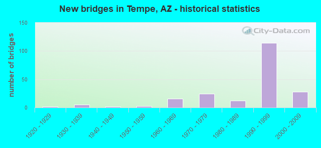
- New bridges - historical statistics
- 21920-1929
- 51930-1939
- 21940-1949
- 31950-1959
- 161960-1969
- 241970-1979
- 121980-1989
- 1141990-1999
- 282000-2009
- 12010-2019
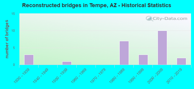
- Reconstructed bridges - Historical Statistics
- 31930-1939
- 01940-1949
- 11950-1959
- 01960-1969
- 01970-1979
- 71980-1989
- 31990-1999
- 102000-2009
- 22010-2019
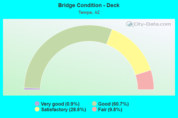
- Bridge Condition - Deck
- 0.9%Very good
- 60.7%Good
- 28.6%Satisfactory
- 9.8%Fair
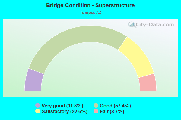
- Bridge Condition - Superstructure
- 11.3%Very good
- 57.4%Good
- 22.6%Satisfactory
- 8.7%Fair
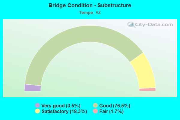
- Bridge Condition - Substructure
- 3.5%Very good
- 76.5%Good
- 18.3%Satisfactory
- 1.7%Fair
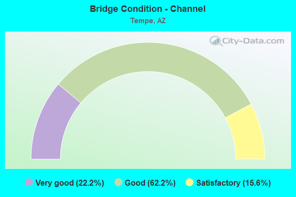
- Bridge Condition - Channel
- 22.2%Very good
- 62.2%Good
- 15.6%Satisfactory
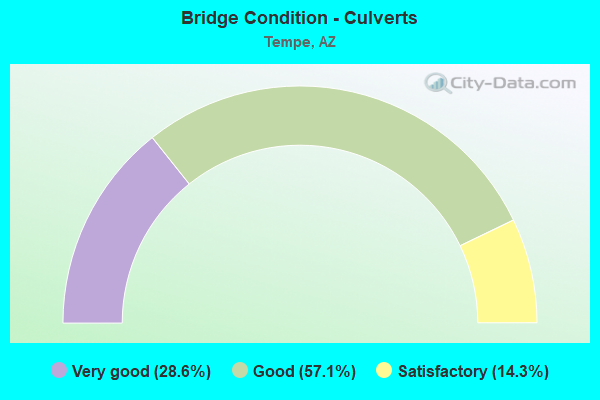
- Bridge Condition - Culverts
- 28.6%Very good
- 57.1%Good
- 14.3%Satisfactory
Find on map >> Show street view
Structure Number: 2261, Location: 7.55 mi E Jct I 10 & (Lat: 33.435800, Lng: -111.930700), Route carried "on" structure: State highway 202, Year Built: 1993, Year Reconstructed: 2012, Status: Open, Structure Length: 3.84m (12.60ft), Average Daily Traffic: 179,508 (year 2017), Truck Traffic: 7%, Average Future Daily Traffic: 263,000 (year 2037), Design Load: HS 20, Features Intersected: College Ave
Minimum Vertical Clearance: 30+ m (98+ ft), Kilometerpoint: 11.990, Lanes on structure: 12, Lanes under structure: 12, Owner: State Highway Agency, Approaching Roadway Width: 63.7m (209.0ft), Skew: 31 degrees, Material/Design: Prestressed concrete, Design/Construction: Box Beam or Girders - Single/Spread, Number Of Spans In Main Unit: 1, Length of Maximum Span: 37.2m (122.0ft), Curb-To-Curb Width: 63.9m (209.6ft), Out-to-Out Width: 65.6m (215.2ft)
Condition: Deck: Good, Superstructure: Good, Substructure: Good, Operating Rating: 85.3 metric tons, Method Used To Determine Operating Rating: Load Factor (LF), Inventory Rating: 42.6 metric tons, Method Used To Determine Inventory Rating: Load Factor (LF), Structural Evaluation: Better than present minimum criteria, Deck Geometry: Superior to present desirable criteria, Underclear: Better than present minimum criteria, Approach Roadway Alignment: Equal to present desirable criteria, Designated Inspection Frequency: Every 24 months, Inspection Date: August 2020, Deck Structure Type: Concrete Cast-file-Place, Wearing Surface/Protective System: Wearing Surface: Bituminous
Find on map >> Show street view
Structure Number: 2262, Location: 7.55 mi E Jct I 10 & (Lat: 33.436000, Lng: -111.930900), Route carried "on" structure: Ramp State highway 202, Year Built: 1993, Status: Open, Structure Length: 3.90m (12.80ft), Average Daily Traffic: 8,922 (year 2017), Truck Traffic: 5%, Average Future Daily Traffic: 8,932 (year 2037), Design Load: HS 20, Features Intersected: College Avenue
Minimum Vertical Clearance: 30+ m (98+ ft), Kilometerpoint: 11.990, Lanes on structure: 1, Lanes under structure: 2, Owner: State Highway Agency, Approaching Roadway Width: 6.7m (22.0ft), Skew: 1 degrees, Material/Design: Prestressed concrete, Design/Construction: Box Beam or Girders - Single/Spread, Number Of Spans In Main Unit: 1, Length of Maximum Span: 37.8m (124.0ft), Curb-To-Curb Width: 6.7m (22.0ft), Out-to-Out Width: 7.7m (25.3ft)
Condition: Deck: Good, Superstructure: Good, Substructure: Good, Operating Rating: 71.7 metric tons, Method Used To Determine Operating Rating: Load Factor (LF), Inventory Rating: 41.7 metric tons, Method Used To Determine Inventory Rating: Load Factor (LF), Structural Evaluation: Better than present minimum criteria, Deck Geometry: Equal to present minimum criteria, Underclear: Better than present minimum criteria, Approach Roadway Alignment: Equal to present desirable criteria, Designated Inspection Frequency: Every 24 months, Inspection Date: August 2020, Deck Structure Type: Concrete Cast-file-Place, Wearing Surface/Protective System: Wearing Surface: Bituminous
Find on map >> Show street view
Structure Number: 2263, Location: 7.71 mi E Jct I 10 & (Lat: 33.436100, Lng: -111.926600), Route carried "on" structure: State highway 202, Year Built: 1994, Year Reconstructed: 2010, Status: Open, Structure Length: 6.13m (20.11ft), Average Daily Traffic: 224,918 (year 2019), Truck Traffic: 7%, Average Future Daily Traffic: 224,928 (year 2039), Design Load: HS 20, Features Intersected: Scottsdale Road
Minimum Vertical Clearance: 30+ m (98+ ft), Kilometerpoint: 12.408, Lanes on structure: 11, Lanes under structure: 12, Owner: State Highway Agency, Approaching Roadway Width: 49.4m (162.1ft), Skew: 30 degrees, Material/Design: Prestressed concrete, Design/Construction: Box Beam or Girders - Multiple, Number Of Spans In Main Unit: 1, Length of Maximum Span: 59.4m (194.9ft), Curb-To-Curb Width: 56.4m (185.0ft), Out-to-Out Width: 57.3m (188.0ft)
Condition: Deck: Good, Superstructure: Good, Substructure: Good, Operating Rating: 89.8 metric tons, Method Used To Determine Operating Rating: Load Factor (LF), Inventory Rating: 41.7 metric tons, Method Used To Determine Inventory Rating: Load Factor (LF), Structural Evaluation: Better than present minimum criteria, Deck Geometry: Superior to present desirable criteria, Underclear: Superior to present desirable criteria, Approach Roadway Alignment: Equal to present desirable criteria, Designated Inspection Frequency: Every 24 months, Inspection Date: September 2020, Deck Structure Type: Concrete Cast-file-Place, Wearing Surface/Protective System: Wearing Surface: Bituminous
Find on map >> Show street view
Structure Number: 2265, Location: 8.06 mi E Jct I 10 & (Lat: 33.436100, Lng: -111.919700), Route carried "on" structure: State highway 202, Year Built: 1994, Year Reconstructed: 2010, Status: Open, Structure Length: 30.72m (100.79ft), Average Daily Traffic: 195,059 (year 2018), Truck Traffic: 7%, Average Future Daily Traffic: 195,069 (year 2038), Design Load: HS 20, Features Intersected: Indian Bend Wash
Minimum Vertical Clearance: 6.52m (21.39ft), Kilometerpoint: 12.971, Lanes on structure: 14, Lanes under structure: 2, Owner: State Highway Agency, Approaching Roadway Width: 49.4m (162.1ft), Skew: 33 degrees, Material/Design: Prestressed concrete continuous, Design/Construction: Stringer/Multi-beam, Number Of Spans In Main Unit: 8, Length of Maximum Span: 38.1m (125.0ft), Curb-To-Curb Width: 62.6m (205.4ft), Out-to-Out Width: 64.6m (211.9ft)
Condition: Deck: Good, Superstructure: Very good, Substructure: Good, Channel: Very good, Operating Rating: 89.8 metric tons, Method Used To Determine Operating Rating: Load Factor (LF), Inventory Rating: 32.7 metric tons, Method Used To Determine Inventory Rating: Load Factor (LF), Structural Evaluation: Better than present minimum criteria, Deck Geometry: Superior to present desirable criteria, Waterway Adequacy: Equal to present desirable criteria, Approach Roadway Alignment: Equal to present desirable criteria, Designated Inspection Frequency: Every 24 months, Inspection Date: September 2020, Deck Structure Type: Concrete Cast-file-Place, Wearing Surface/Protective System: Wearing Surface: Bituminous
Find on map >> Show street view
Structure Number: 2268, Location: 1.5 mi N US60/McClintock (Lat: 33.435900, Lng: -111.912900), Route carried "on" structure: State highway 202, Year Built: 1994, Year Reconstructed: 2009, Status: Open, Structure Length: 161.30m (529.20ft), Average Daily Traffic: 82,842 (year 2018), Truck Traffic: 8%, Average Future Daily Traffic: 82,852 (year 2038), Design Load: HS 20, Features Intersected: McClintock; Salt Rv; Ram
Minimum Vertical Clearance: 5.49m (18.01ft), Kilometerpoint: 13.148, Lanes on structure: 7, Lanes under structure: 7, Owner: State Highway Agency, Approaching Roadway Width: 33.2m (108.9ft), Material/Design: Prestressed concrete continuous, Design/Construction: Stringer/Multi-beam, Number Of Spans In Main Unit: 39, Length of Maximum Span: 42.7m (140.1ft), Curb-To-Curb Width: 32.3m (106.0ft), Out-to-Out Width: 33.3m (109.3ft)
Condition: Deck: Good, Superstructure: Fair, Substructure: Good, Channel: Good, Operating Rating: 86.2 metric tons, Method Used To Determine Operating Rating: Load Factor (LF), Inventory Rating: 32.7 metric tons, Method Used To Determine Inventory Rating: Load Factor (LF), Structural Evaluation: Somewhat better than minimum adequacy, Deck Geometry: Better than present minimum criteria, Underclear: High priority of corrective action, Waterway Adequacy: Superior to present desirable criteria, Approach Roadway Alignment: Equal to present desirable criteria, Length Of Structure Improvement: 161.30m (529.20ft), Designated Inspection Frequency: Every 24 months, Inspection Date: September 2020, Bridge Improvement Cost: $1,000, Total Project Cost: $1,000 ( Estimate for 2020), Deck Structure Type: Concrete Cast-file-Place, Wearing Surface/Protective System: Wearing Surface: Bituminous
Find on map >> Show street view
Structure Number: 2269, Location: 1.5 mi W US60/McClintock (Lat: 33.436200, Lng: -111.912300), Route carried "on" structure: State highway 202, Year Built: 1994, Year Reconstructed: 2009, Status: Open, Structure Length: 157.61m (517.09ft), Average Daily Traffic: 87,767 (year 2018), Truck Traffic: 8%, Average Future Daily Traffic: 87,777 (year 2038), Design Load: HS 20, Features Intersected: McClintock; Salt Rv; Ram
Minimum Vertical Clearance: 5.49m (18.01ft), Kilometerpoint: 13.148, Lanes on structure: 6, Lanes under structure: 7, Owner: State Highway Agency, Approaching Roadway Width: 31.4m (103.0ft), Material/Design: Prestressed concrete continuous, Design/Construction: Stringer/Multi-beam, Number Of Spans In Main Unit: 38, Length of Maximum Span: 42.7m (140.1ft), Curb-To-Curb Width: 30.5m (100.1ft), Out-to-Out Width: 31.5m (103.3ft)
Condition: Deck: Good, Superstructure: Good, Substructure: Good, Channel: Good, Operating Rating: 86.2 metric tons, Method Used To Determine Operating Rating: Load Factor (LF), Inventory Rating: 34.5 metric tons, Method Used To Determine Inventory Rating: Load Factor (LF), Structural Evaluation: Better than present minimum criteria, Deck Geometry: Superior to present desirable criteria, Underclear: High priority of corrective action, Waterway Adequacy: Superior to present desirable criteria, Approach Roadway Alignment: Equal to present desirable criteria, Designated Inspection Frequency: Every 24 months, Inspection Date: September 2020, Deck Structure Type: Concrete Cast-file-Place, Wearing Surface/Protective System: Wearing Surface: Bituminous
Find on map >> Show street view
Structure Number: 2283, Location: 4.5 mi E/I 10, 1.5 S/60 (Lat: 33.363900, Lng: -111.894500), Route carried "on" structure: City street , Year Built: 1999, Status: Open, Structure Length: 5.79m (19.00ft), Average Daily Traffic: 24,878 (year 2018), Truck Traffic: 9%, Average Future Daily Traffic: 24,888 (year 2038), Design Load: HS 20, Features Intersected: SR 101L, Facility Carried by Structure: Guadalupe Road
Minimum Vertical Clearance: 5.42m (17.78ft), Kilometerpoint: 0.000, Lanes on structure: 8, Lanes under structure: 8, Owner: State Highway Agency, Approaching Roadway Width: 32.3m (106.0ft), Material/Design: Prestressed concrete continuous, Design/Construction: Box Beam or Girders - Single/Spread, Number Of Spans In Main Unit: 2, Length of Maximum Span: 27.7m (90.9ft), Curb or Sidewalk Widths: Left: 2.4m (7.9ft), Right: 2.4m (7.9ft), Curb-To-Curb Width: 32.3m (106.0ft), Out-to-Out Width: 44.8m (147.0ft)
Condition: Deck: Good, Superstructure: Good, Substructure: Satisfactory, Operating Rating: 78.0 metric tons, Method Used To Determine Operating Rating: Load Factor (LF), Inventory Rating: 43.5 metric tons, Method Used To Determine Inventory Rating: Load Factor (LF), Structural Evaluation: Equal to present minimum criteria, Deck Geometry: Somewhat better than minimum adequacy, Underclear: Equal to present minimum criteria, Approach Roadway Alignment: Equal to present desirable criteria, Designated Inspection Frequency: Every 24 months, Inspection Date: December 2020, Deck Structure Type: Concrete Cast-file-Place, Wearing Surface/Protective System: Wearing Surface: Monolithic Concrete
Find on map >> Show street view
Structure Number: 2286, Location: 0.45 S of Elliot Rd (Lat: 33.343000, Lng: -111.893800), Route carried "on" structure: City street , Year Built: 1999, Status: Open, Structure Length: 6.46m (21.19ft), Average Daily Traffic: 1,000 (year 2021), Truck Traffic: 3%, Average Future Daily Traffic: 1,010 (year 2041), Design Load: HS 20, Features Intersected: SR 101L, Facility Carried by Structure: Conference Drive
Minimum Vertical Clearance: 30+ m (98+ ft), Kilometerpoint: 0.000, Lanes on structure: 2, Lanes under structure: 10, Owner: State Highway Agency, Approaching Roadway Width: 13.1m (43.0ft), Material/Design: Prestressed concrete continuous, Design/Construction: Box Beam or Girders - Single/Spread, Number Of Spans In Main Unit: 2, Length of Maximum Span: 31.4m (103.0ft), Curb or Sidewalk Widths: Left: 1.5m (4.9ft), Right: 1.5m (4.9ft), Curb-To-Curb Width: 13.2m (43.3ft), Out-to-Out Width: 16.9m (55.4ft)
Condition: Deck: Satisfactory, Superstructure: Satisfactory, Substructure: Good, Operating Rating: 78.0 metric tons, Method Used To Determine Operating Rating: Load Factor (LF), Inventory Rating: 33.6 metric tons, Method Used To Determine Inventory Rating: Load Factor (LF), Structural Evaluation: Equal to present minimum criteria, Deck Geometry: Superior to present desirable criteria, Underclear: Equal to present minimum criteria, Approach Roadway Alignment: Equal to present desirable criteria, Designated Inspection Frequency: Every 24 months, Inspection Date: December 2020, Deck Structure Type: Concrete Cast-file-Place, Wearing Surface/Protective System: Wearing Surface: Monolithic Concrete
Find on map >> Show street view
Structure Number: 2287, Location: 3.5 mi S of 60 (Lat: 33.334900, Lng: -111.893300), Route carried "on" structure: City street , Year Built: 1999, Status: Open, Structure Length: 6.58m (21.59ft), Average Daily Traffic: 20,300 (year 2019), Truck Traffic: 11%, Average Future Daily Traffic: 20,310 (year 2039), Design Load: HS 20, Features Intersected: SR 101L, Facility Carried by Structure: Warner Road
Minimum Vertical Clearance: 5.88m (19.29ft), Kilometerpoint: 0.000, Lanes on structure: 10, Lanes under structure: 10, Owner: State Highway Agency, Approaching Roadway Width: 37.5m (123.0ft), Skew: 20 degrees, Material/Design: Prestressed concrete continuous, Design/Construction: Box Beam or Girders - Single/Spread, Number Of Spans In Main Unit: 2, Length of Maximum Span: 32.0m (105.0ft), Curb or Sidewalk Widths: Left: 1.9m (6.2ft), Right: 1.9m (6.2ft), Curb-To-Curb Width: 37.6m (123.4ft), Out-to-Out Width: 42.9m (140.7ft)
Condition: Deck: Good, Superstructure: Satisfactory, Substructure: Satisfactory, Operating Rating: 57.2 metric tons, Method Used To Determine Operating Rating: Load Factor (LF), Inventory Rating: 33.6 metric tons, Method Used To Determine Inventory Rating: Load Factor (LF), Structural Evaluation: Equal to present minimum criteria, Deck Geometry: Somewhat better than minimum adequacy, Underclear: Somewhat better than minimum adequacy, Approach Roadway Alignment: Equal to present desirable criteria, Designated Inspection Frequency: Every 24 months, Inspection Date: December 2020, Deck Structure Type: Concrete Cast-file-Place, Wearing Surface/Protective System: Wearing Surface: Monolithic Concrete
Find on map >> Show street view
Structure Number: 2305, Location: at Superstition TI (Lat: 33.393061, Lng: -111.968400), Route carried "on" structure: Ramp Interstate 10, Year Built: 1995, Status: Open, Structure Length: 4.24m (13.91ft), Average Daily Traffic: 26,749 (year 2017), Truck Traffic: 2%, Average Future Daily Traffic: 26,759 (year 2037), Design Load: HS 20, Features Intersected: Southern Avenue, Facility Carried by Structure: Ramp S-E
Minimum Vertical Clearance: 30+ m (98+ ft), Kilometerpoint: 248.837, Lanes on structure: 3, Lanes under structure: 5, Owner: State Highway Agency, Approaching Roadway Width: 17.1m (56.1ft), Skew: 2 degrees, Material/Design: Prestressed concrete, Design/Construction: Stringer/Multi-beam, Number Of Spans In Main Unit: 1, Length of Maximum Span: 40.5m (132.9ft), Curb-To-Curb Width: 18.3m (60.0ft), Out-to-Out Width: 19.4m (63.6ft)
Condition: Deck: Good, Superstructure: Good, Substructure: Good, Operating Rating: 89.8 metric tons, Method Used To Determine Operating Rating: Load Factor (LF), Inventory Rating: 49.0 metric tons, Method Used To Determine Inventory Rating: Load Factor (LF), Structural Evaluation: Better than present minimum criteria, Deck Geometry: Superior to present desirable criteria, Underclear: Meets minimum limits, Approach Roadway Alignment: Equal to present desirable criteria, Designated Inspection Frequency: Every 24 months, Inspection Date: March 2021, Deck Structure Type: Concrete Cast-file-Place, Wearing Surface/Protective System: Wearing Surface: Bituminous
Find on map >> Show street view
Structure Number: 2306, Location: 2.8 mi S of Jct US 60 (Lat: 33.349100, Lng: -111.972700), Route carried "on" structure: City street , Year Built: 1992, Status: Open, Structure Length: 8.14m (26.71ft), Average Daily Traffic: 50,600 (year 2015), Truck Traffic: 5%, Average Future Daily Traffic: 50,610 (year 2035), Design Load: HS 20, Features Intersected: I 10, Facility Carried by Structure: Elliot Road
Minimum Vertical Clearance: 5.49m (18.01ft), Kilometerpoint: 0.000, Lanes on structure: 10, Lanes under structure: 8, Owner: State Highway Agency, Approaching Roadway Width: 36.6m (120.1ft), Skew: 20 degrees, Material/Design: Prestressed concrete continuous, Design/Construction: Stringer/Multi-beam, Number Of Spans In Main Unit: 2, Length of Maximum Span: 39.9m (130.9ft), Curb or Sidewalk Widths: Left: 2.4m (7.9ft), Right: 2.4m (7.9ft), Curb-To-Curb Width: 36.6m (120.1ft), Out-to-Out Width: 42.9m (140.7ft)
Condition: Deck: Satisfactory, Superstructure: Very good, Substructure: Satisfactory, Operating Rating: 89.8 metric tons, Method Used To Determine Operating Rating: Load Factor (LF), Inventory Rating: 32.7 metric tons, Method Used To Determine Inventory Rating: Load Factor (LF), Structural Evaluation: Equal to present minimum criteria, Deck Geometry: Meets minimum limits, Underclear: Equal to present minimum criteria, Approach Roadway Alignment: Better than present minimum criteria, Designated Inspection Frequency: Every 24 months, Inspection Date: January 2021, Deck Structure Type: Concrete Cast-file-Place, Wearing Surface/Protective System: Wearing Surface: Monolithic Concrete
Find on map >> Show street view
Structure Number: 233, Location: 1.6 mi E junction I-10 (Lat: 33.291800, Lng: -111.945600), Route carried "on" structure: City street , Year Built: 2003, Status: Open, Structure Length: 8.29m (27.20ft), Average Daily Traffic: 27,200 (year 2018), Truck Traffic: 8%, Average Future Daily Traffic: 27,210 (year 2038), Design Load: HS 20, Features Intersected: L 202, Facility Carried by Structure: Kyrene Rd
Minimum Vertical Clearance: 30+ m (98+ ft), Kilometerpoint: 0.000, Lanes on structure: 6, Lanes under structure: 8, Owner: State Highway Agency, Approaching Roadway Width: 23.2m (76.1ft), Skew: 21 degrees, Material/Design: Prestressed concrete continuous, Design/Construction: Box Beam or Girders - Single/Spread, Number Of Spans In Main Unit: 2, Length of Maximum Span: 40.5m (132.9ft), Curb or Sidewalk Widths: Left: 1.8m (5.9ft), Right: 1.8m (5.9ft), Curb-To-Curb Width: 23.2m (76.1ft), Out-to-Out Width: 28.5m (93.5ft)
Condition: Deck: Satisfactory, Superstructure: Good, Substructure: Good, Operating Rating: 89.8 metric tons, Method Used To Determine Operating Rating: Load Factor (LF), Inventory Rating: 65.3 metric tons, Method Used To Determine Inventory Rating: Load Factor (LF), Structural Evaluation: Better than present minimum criteria, Deck Geometry: Meets minimum limits, Underclear: Better than present minimum criteria, Approach Roadway Alignment: Equal to present desirable criteria, Designated Inspection Frequency: Every 24 months, Inspection Date: January 2022, Deck Structure Type: Concrete Cast-file-Place, Wearing Surface/Protective System: Wearing Surface: Monolithic Concrete
Find on map >> Show street view
Structure Number: 2331, Location: 3.6 mi E junction I-10 (Lat: 33.291300, Lng: -111.911200), Route carried "on" structure: City street , Year Built: 2003, Status: Open, Structure Length: 8.50m (27.89ft), Average Daily Traffic: 4,000 (year 2018), Truck Traffic: 5%, Average Future Daily Traffic: 4,010 (year 2038), Design Load: HS 20, Features Intersected: L 202, Facility Carried by Structure: McClintock Drive
Minimum Vertical Clearance: 30+ m (98+ ft), Kilometerpoint: 0.000, Lanes on structure: 5, Lanes under structure: 10, Owner: State Highway Agency, Approaching Roadway Width: 32.0m (105.0ft), Skew: 20 degrees, Material/Design: Prestressed concrete continuous, Design/Construction: Box Beam or Girders - Multiple, Number Of Spans In Main Unit: 2, Length of Maximum Span: 41.8m (137.1ft), Curb or Sidewalk Widths: Left: 1.8m (5.9ft), Right: 1.8m (5.9ft), Curb-To-Curb Width: 32.0m (105.0ft), Out-to-Out Width: 37.3m (122.4ft)
Condition: Deck: Good, Superstructure: Good, Substructure: Good, Operating Rating: 88.9 metric tons, Method Used To Determine Operating Rating: Load Factor (LF), Inventory Rating: 46.3 metric tons, Method Used To Determine Inventory Rating: Load Factor (LF), Structural Evaluation: Better than present minimum criteria, Deck Geometry: Superior to present desirable criteria, Underclear: Equal to present minimum criteria, Approach Roadway Alignment: Equal to present desirable criteria, Designated Inspection Frequency: Every 24 months, Inspection Date: January 2022, Deck Structure Type: Concrete Cast-file-Place, Wearing Surface/Protective System: Wearing Surface: Monolithic Concrete
Find on map >> Show street view
Structure Number: 2341, Location: SR 101 / SR 202 TI (Lat: 33.436100, Lng: -111.890800), Route carried "on" structure: State highway 101, Year Built: 1999, Status: Open, Structure Length: 37.28m (122.31ft), Average Daily Traffic: 81,465 (year 2017), Truck Traffic: 7%, Average Future Daily Traffic: 81,475 (year 2037), Design Load: HS 20, Features Intersected: Salt River & Ramp W-S
Minimum Vertical Clearance: 30+ m (98+ ft), Kilometerpoint: 81.883, Lanes on structure: 5, Lanes under structure: 1, Owner: State Highway Agency, Approaching Roadway Width: 25.0m (82.0ft), Material/Design: Prestressed concrete continuous, Design/Construction: Stringer/Multi-beam, Number Of Spans In Main Unit: 9, Length of Maximum Span: 42.7m (140.1ft), Curb-To-Curb Width: 25.0m (82.0ft), Out-to-Out Width: 26.0m (85.3ft)
Condition: Deck: Good, Superstructure: Very good, Substructure: Good, Channel: Good, Operating Rating: 56.2 metric tons, Method Used To Determine Operating Rating: Load Factor (LF), Inventory Rating: 35.4 metric tons, Method Used To Determine Inventory Rating: Load Factor (LF), Structural Evaluation: Better than present minimum criteria, Deck Geometry: Better than present minimum criteria, Underclear: Superior to present desirable criteria, Waterway Adequacy: Better than present minimum criteria, Approach Roadway Alignment: Equal to present desirable criteria, Designated Inspection Frequency: Every 24 months, Inspection Date: November 2020, Deck Structure Type: Concrete Cast-file-Place, Wearing Surface/Protective System: Wearing Surface: Bituminous
Find on map >> Show street view
Structure Number: 2342, Location: SR 101 / SR 202 TI (Lat: 33.436100, Lng: -111.891100), Route carried "on" structure: State highway 101, Year Built: 1997, Status: Open, Structure Length: 37.28m (122.31ft), Average Daily Traffic: 48,155 (year 2017), Truck Traffic: 7%, Average Future Daily Traffic: 48,155 (year 2037), Design Load: HS 20, Features Intersected: Salt River & Ramp W-S
Minimum Vertical Clearance: 30+ m (98+ ft), Kilometerpoint: 81.883, Lanes on structure: 5, Lanes under structure: 1, Owner: State Highway Agency, Approaching Roadway Width: 25.0m (82.0ft), Material/Design: Prestressed concrete continuous, Design/Construction: Stringer/Multi-beam, Number Of Spans In Main Unit: 9, Length of Maximum Span: 42.7m (140.1ft), Curb-To-Curb Width: 25.0m (82.0ft), Out-to-Out Width: 26.0m (85.3ft)
Condition: Deck: Good, Superstructure: Very good, Substructure: Good, Channel: Good, Operating Rating: 57.2 metric tons, Method Used To Determine Operating Rating: Load Factor (LF), Inventory Rating: 36.3 metric tons, Method Used To Determine Inventory Rating: Load Factor (LF), Structural Evaluation: Better than present minimum criteria, Deck Geometry: Better than present minimum criteria, Underclear: Superior to present desirable criteria, Waterway Adequacy: Equal to present desirable criteria, Approach Roadway Alignment: Equal to present desirable criteria, Designated Inspection Frequency: Every 24 months, Inspection Date: November 2020, Deck Structure Type: Concrete Cast-file-Place, Wearing Surface/Protective System: Wearing Surface: Bituminous
Find on map >> Show street view
Structure Number: 2344, Location: NW Quadrant of 202 / 101 (Lat: 33.438300, Lng: -111.891800), Route carried "on" structure: Ramp State highway 101, Year Built: 1997, Status: Open, Structure Length: 57.39m (188.29ft), Average Daily Traffic: 5,862 (year 2019), Truck Traffic: 7%, Average Future Daily Traffic: 211,855 (year 2040), Design Load: HS 20, Features Intersected: Salt River
Minimum Vertical Clearance: 30+ m (98+ ft), Kilometerpoint: 81.900, Lanes on structure: 1, Owner: State Highway Agency, Approaching Roadway Width: 8.5m (27.9ft), Material/Design: Prestressed concrete continuous, Design/Construction: Stringer/Multi-beam, Number Of Spans In Main Unit: 14, Length of Maximum Span: 42.7m (140.1ft), Curb-To-Curb Width: 8.5m (27.9ft), Out-to-Out Width: 9.5m (31.2ft)
Condition: Deck: Satisfactory, Superstructure: Very good, Substructure: Good, Channel: Good, Operating Rating: 89.8 metric tons, Method Used To Determine Operating Rating: Load Factor (LF), Inventory Rating: 32.7 metric tons, Method Used To Determine Inventory Rating: Load Factor (LF), Structural Evaluation: Better than present minimum criteria, Deck Geometry: Superior to present desirable criteria, Waterway Adequacy: Equal to present desirable criteria, Approach Roadway Alignment: Equal to present desirable criteria, Designated Inspection Frequency: Every 24 months, Inspection Date: July 2021, Deck Structure Type: Concrete Cast-file-Place, Wearing Surface/Protective System: Wearing Surface: Bituminous
Find on map >> Show street view
Structure Number: 2345, Location: NE Quadrant of 101 / 202 (Lat: 33.436300, Lng: -111.889600), Route carried "on" structure: Ramp State highway 101, Year Built: 1997, Status: Open, Structure Length: 22.49m (73.79ft), Average Daily Traffic: 5,862 (year 2019), Truck Traffic: 7%, Average Future Daily Traffic: 211,885 (year 2040), Design Load: HS 20, Features Intersected: Salt River
Minimum Vertical Clearance: 30+ m (98+ ft), Kilometerpoint: 81.916, Lanes on structure: 1, Owner: State Highway Agency, Approaching Roadway Width: 8.5m (27.9ft), Material/Design: Prestressed concrete continuous, Design/Construction: Stringer/Multi-beam, Number Of Spans In Main Unit: 6, Length of Maximum Span: 40.5m (132.9ft), Curb-To-Curb Width: 8.5m (27.9ft), Out-to-Out Width: 9.5m (31.2ft)
Condition: Deck: Good, Superstructure: Good, Substructure: Good, Channel: Good, Operating Rating: 89.8 metric tons, Method Used To Determine Operating Rating: Load Factor (LF), Inventory Rating: 32.7 metric tons, Method Used To Determine Inventory Rating: Load Factor (LF), Structural Evaluation: Better than present minimum criteria, Deck Geometry: Superior to present desirable criteria, Waterway Adequacy: Equal to present desirable criteria, Approach Roadway Alignment: Equal to present desirable criteria, Designated Inspection Frequency: Every 24 months, Inspection Date: July 2021, Deck Structure Type: Concrete Cast-file-Place, Wearing Surface/Protective System: Wearing Surface: Bituminous
Find on map >> Show street view
Structure Number: 2347, Location: at Superstition TI (Lat: 33.389250, Lng: -111.969000), Route carried "on" structure: Ramp Interstate 10, Year Built: 1995, Status: Open, Structure Length: 33.44m (109.71ft), Average Daily Traffic: 15,087 (year 2018), Truck Traffic: 8%, Average Future Daily Traffic: 15,097 (year 2038), Design Load: HS 20, Features Intersected: I 10, Facility Carried by Structure: Ramp S-E
Minimum Vertical Clearance: 6.46m (21.19ft), Kilometerpoint: 249.851, Lanes on structure: 3, Lanes under structure: 9, Owner: State Highway Agency, Approaching Roadway Width: 21.9m (71.9ft), Skew: 9 degrees, Material/Design: Prestressed concrete continuous, Design/Construction: Box Beam or Girders - Single/Spread, Number Of Spans In Main Unit: 8, Length of Maximum Span: 45.7m (149.9ft), Curb-To-Curb Width: 21.9m (71.9ft), Out-to-Out Width: 22.9m (75.1ft)
Condition: Deck: Good, Superstructure: Good, Substructure: Good, Operating Rating: 68.9 metric tons, Method Used To Determine Operating Rating: Load Factor (LF), Inventory Rating: 36.3 metric tons, Method Used To Determine Inventory Rating: Load Factor (LF), Structural Evaluation: Better than present minimum criteria, Deck Geometry: Superior to present desirable criteria, Underclear: Equal to present minimum criteria, Approach Roadway Alignment: Equal to present desirable criteria, Designated Inspection Frequency: Every 24 months, Inspection Date: March 2021, Deck Structure Type: Concrete Cast-file-Place, Wearing Surface/Protective System: Wearing Surface: Bituminous
Find on map >> Show street view
Structure Number: 2348, Location: 0.7 mi S Jct US 60 (Lat: 33.378461, Lng: -111.967600), Route carried "on" structure: Ramp Interstate 10, Year Built: 1995, Status: Open, Structure Length: 4.63m (15.19ft), Average Daily Traffic: 149,898 (year 2017), Truck Traffic: 4%, Average Future Daily Traffic: 149,908 (year 2037), Design Load: HS 20, Features Intersected: Baseline Road, Facility Carried by Structure: Ramp WB C-D
Minimum Vertical Clearance: 30+ m (98+ ft), Kilometerpoint: 251.058, Lanes on structure: 2, Lanes under structure: 10, Owner: State Highway Agency, Approaching Roadway Width: 12.5m (41.0ft), Material/Design: Prestressed concrete, Design/Construction: Box Beam or Girders - Single/Spread, Number Of Spans In Main Unit: 1, Length of Maximum Span: 44.8m (147.0ft), Curb-To-Curb Width: 13.4m (44.0ft), Out-to-Out Width: 14.4m (47.2ft)
Condition: Deck: Satisfactory, Superstructure: Very good, Substructure: Good, Operating Rating: 85.3 metric tons, Method Used To Determine Operating Rating: Load Factor (LF), Inventory Rating: 49.9 metric tons, Method Used To Determine Inventory Rating: Load Factor (LF), Structural Evaluation: Better than present minimum criteria, Deck Geometry: Superior to present desirable criteria, Underclear: Meets minimum limits, Approach Roadway Alignment: Equal to present desirable criteria, Designated Inspection Frequency: Every 24 months, Inspection Date: January 2021, Deck Structure Type: Concrete Cast-file-Place, Wearing Surface/Protective System: Wearing Surface: Monolithic Concrete
Find on map >> Show street view
Structure Number: 2349, Location: 0.7 mi S Jct US 60 (Lat: 33.378461, Lng: -111.968000), Route carried "on" structure: Interstate 10, Year Built: 1994, Status: Open, Structure Length: 4.63m (15.19ft), Average Daily Traffic: 14,989 (year 2017), Truck Traffic: 4%, Average Future Daily Traffic: 14,999 (year 2037), Design Load: HS 20, Features Intersected: Baseline Road
Minimum Vertical Clearance: 30+ m (98+ ft), Kilometerpoint: 251.058, Lanes on structure: 9, Lanes under structure: 10, Owner: State Highway Agency, Approaching Roadway Width: 57.0m (187.0ft), Skew: 30 degrees, Material/Design: Prestressed concrete, Design/Construction: Box Beam or Girders - Single/Spread, Number Of Spans In Main Unit: 1, Length of Maximum Span: 44.8m (147.0ft), Curb-To-Curb Width: 57.0m (187.0ft), Out-to-Out Width: 58.7m (192.6ft)
Condition: Deck: Good, Superstructure: Good, Substructure: Satisfactory, Operating Rating: 75.3 metric tons, Method Used To Determine Operating Rating: Load Factor (LF), Inventory Rating: 44.5 metric tons, Method Used To Determine Inventory Rating: Load Factor (LF), Structural Evaluation: Equal to present minimum criteria, Deck Geometry: Superior to present desirable criteria, Underclear: Meets minimum limits, Approach Roadway Alignment: Equal to present desirable criteria, Designated Inspection Frequency: Every 24 months, Inspection Date: January 2021, Deck Structure Type: Concrete Cast-file-Place, Wearing Surface/Protective System: Wearing Surface: Bituminous
Find on map >> Show street view
Structure Number: 235, Location: 0.37 mi E Jct I 10 (Lat: 33.387300, Lng: -111.961100), Route carried "on" structure: US 60, Year Built: 1995, Year Reconstructed: 2001, Status: Open, Structure Length: 4.05m (13.29ft), Average Daily Traffic: 95,506 (year 2019), Truck Traffic: 7%, Average Future Daily Traffic: 95,516 (year 2039), Design Load: HS 20, Features Intersected: Priest Drive
Minimum Vertical Clearance: 30+ m (98+ ft), Kilometerpoint: 277.403, Lanes on structure: 6, Lanes under structure: 8, Owner: State Highway Agency, Approaching Roadway Width: 33.2m (108.9ft), Skew: 1 degrees, Material/Design: Prestressed concrete, Design/Construction: Stringer/Multi-beam, Number Of Spans In Main Unit: 1, Length of Maximum Span: 39.0m (128.0ft), Curb-To-Curb Width: 33.2m (108.9ft), Out-to-Out Width: 34.1m (111.9ft)
Condition: Deck: Good, Superstructure: Good, Substructure: Good, Operating Rating: 89.8 metric tons, Method Used To Determine Operating Rating: Load Factor (LF), Inventory Rating: 32.7 metric tons, Method Used To Determine Inventory Rating: Load Factor (LF), Structural Evaluation: Better than present minimum criteria, Deck Geometry: Superior to present desirable criteria, Underclear: Equal to present minimum criteria, Approach Roadway Alignment: Equal to present desirable criteria, Designated Inspection Frequency: Every 24 months, Inspection Date: October 2021, Deck Structure Type: Concrete Cast-file-Place, Wearing Surface/Protective System: Wearing Surface: Bituminous
Find on map >> Show street view
Structure Number: 2351, Location: 0.37 mi E Jct I 10 (Lat: 33.387600, Lng: -111.961100), Route carried "on" structure: US 60, Year Built: 1995, Status: Open, Structure Length: 4.08m (13.39ft), Average Daily Traffic: 111,977 (year 2019), Truck Traffic: 7%, Average Future Daily Traffic: 111,987 (year 2039), Design Load: HS 20, Features Intersected: Priest Drive
Minimum Vertical Clearance: 30+ m (98+ ft), Kilometerpoint: 277.403, Lanes on structure: 5, Lanes under structure: 8, Owner: State Highway Agency, Approaching Roadway Width: 29.3m (96.1ft), Skew: 1 degrees, Material/Design: Prestressed concrete, Design/Construction: Stringer/Multi-beam, Number Of Spans In Main Unit: 1, Length of Maximum Span: 39.0m (128.0ft), Curb-To-Curb Width: 29.4m (96.5ft), Out-to-Out Width: 30.4m (99.7ft)
Condition: Deck: Good, Superstructure: Good, Substructure: Good, Operating Rating: 89.8 metric tons, Method Used To Determine Operating Rating: Load Factor (LF), Inventory Rating: 33.6 metric tons, Method Used To Determine Inventory Rating: Load Factor (LF), Structural Evaluation: Better than present minimum criteria, Deck Geometry: Superior to present desirable criteria, Underclear: Equal to present minimum criteria, Approach Roadway Alignment: Equal to present desirable criteria, Designated Inspection Frequency: Every 24 months, Inspection Date: October 2021, Deck Structure Type: Concrete Cast-file-Place, Wearing Surface/Protective System: Wearing Surface: Bituminous
Find on map >> Show street view
Structure Number: 2357, Location: 0.33 mi S Jct SL 202 (Lat: 33.429100, Lng: -111.891100), Route carried "on" structure: State highway 101, Year Built: 1995, Status: Open, Structure Length: 5.18m (16.99ft), Average Daily Traffic: 125,560 (year 2019), Truck Traffic: 7%, Average Future Daily Traffic: 114,309 (year 2039), Design Load: HS 20, Features Intersected: Rio Salado Parkway
Minimum Vertical Clearance: 9.14m (29.99ft), Kilometerpoint: 83.847, Lanes on structure: 8, Lanes under structure: 6, Owner: State Highway Agency, Approaching Roadway Width: 42.4m (139.1ft), Skew: 30 degrees, Material/Design: Prestressed concrete, Design/Construction: Box Beam or Girders - Single/Spread, Number Of Spans In Main Unit: 1, Length of Maximum Span: 50.0m (164.0ft), Curb-To-Curb Width: 42.5m (139.4ft), Out-to-Out Width: 44.3m (145.3ft)
Condition: Deck: Good, Superstructure: Good, Substructure: Good, Operating Rating: 89.8 metric tons, Method Used To Determine Operating Rating: Load Factor (LF), Inventory Rating: 39.0 metric tons, Method Used To Determine Inventory Rating: Load Factor (LF), Structural Evaluation: Better than present minimum criteria, Deck Geometry: Superior to present desirable criteria, Underclear: Somewhat better than minimum adequacy, Approach Roadway Alignment: Equal to present desirable criteria, Designated Inspection Frequency: Every 24 months, Inspection Date: December 2020, Deck Structure Type: Concrete Cast-file-Place, Wearing Surface/Protective System: Wearing Surface: Bituminous
Find on map >> Show street view
Structure Number: 2359, Location: Price Road Freeway (Lat: 33.429400, Lng: -111.891600), Route carried "on" structure: Ramp State highway 101, Year Built: 1994, Status: Open, Structure Length: 20.76m (68.11ft), Average Daily Traffic: 49,713 (year 2021), Truck Traffic: 7%, Average Future Daily Traffic: 49,723 (year 2041), Design Load: HS 20, Features Intersected: Rio Salado Parkway
Minimum Vertical Clearance: 9.14m (29.99ft), Kilometerpoint: 83.766, Lanes on structure: 3, Lanes under structure: 10, Owner: State Highway Agency, Approaching Roadway Width: 15.2m (49.9ft), Material/Design: Prestressed concrete continuous, Design/Construction: Box Beam or Girders - Single/Spread, Number Of Spans In Main Unit: 4, Length of Maximum Span: 70.1m (230.0ft), Curb-To-Curb Width: 15.4m (50.5ft), Out-to-Out Width: 16.3m (53.5ft)
Condition: Deck: Good, Superstructure: Good, Substructure: Good, Operating Rating: 89.8 metric tons, Method Used To Determine Operating Rating: Load Factor (LF), Inventory Rating: 37.2 metric tons, Method Used To Determine Inventory Rating: Load Factor (LF), Structural Evaluation: Better than present minimum criteria, Deck Geometry: Superior to present desirable criteria, Underclear: High priority of corrective action, Approach Roadway Alignment: Equal to present desirable criteria, Designated Inspection Frequency: Every 24 months, Inspection Date: December 2020, Deck Structure Type: Concrete Cast-file-Place, Wearing Surface/Protective System: Wearing Surface: Bituminous
Find on map >> Show street view
Structure Number: 2367, Location: at Superstition TI (Lat: 33.387400, Lng: -111.964700), Route carried "on" structure: Ramp Interstate 10, Year Built: 1995, Status: Open, Structure Length: 3.02m (9.91ft), Average Daily Traffic: 74,949 (year 2017), Truck Traffic: 4%, Average Future Daily Traffic: 74,959 (year 2037), Design Load: HS 20, Features Intersected: Western Canal, Facility Carried by Structure: Ramp N-E
Minimum Vertical Clearance: 30+ m (98+ ft), Kilometerpoint: 250.124, Lanes on structure: 1, Owner: State Highway Agency, Approaching Roadway Width: 8.5m (27.9ft), Skew: 5 degrees, Material/Design: Prestressed concrete, Design/Construction: Stringer/Multi-beam, Number Of Spans In Main Unit: 1, Length of Maximum Span: 27.1m (88.9ft), Curb-To-Curb Width: 8.5m (27.9ft), Out-to-Out Width: 9.5m (31.2ft)
Condition: Deck: Good, Superstructure: Very good, Substructure: Good, Channel: Very good, Operating Rating: 89.8 metric tons, Method Used To Determine Operating Rating: Load Factor (LF), Inventory Rating: 39.0 metric tons, Method Used To Determine Inventory Rating: Load Factor (LF), Structural Evaluation: Better than present minimum criteria, Deck Geometry: Superior to present desirable criteria, Waterway Adequacy: Equal to present desirable criteria, Approach Roadway Alignment: Equal to present desirable criteria, Designated Inspection Frequency: Every 24 months, Inspection Date: January 2021, Deck Structure Type: Concrete Cast-file-Place, Wearing Surface/Protective System: Wearing Surface: Monolithic Concrete
Find on map >> Show street view
Structure Number: 2368, Location: at Superstition TI (Lat: 33.387700, Lng: -111.962300), Route carried "on" structure: Ramp Interstate 10, Year Built: 1995, Status: Open, Structure Length: 64.22m (210.70ft), Average Daily Traffic: 149,898 (year 2017), Truck Traffic: 4%, Average Future Daily Traffic: 149,908 (year 2037), Design Load: HS 20, Features Intersected: I 10; Ramp S-E
Minimum Vertical Clearance: 30+ m (98+ ft), Kilometerpoint: 250.173, Lanes on structure: 1, Lanes under structure: 14, Owner: State Highway Agency, Approaching Roadway Width: 9.1m (29.9ft), Material/Design: Prestressed concrete continuous, Design/Construction: Box Beam or Girders - Single/Spread, Number Of Spans In Main Unit: 12, Length of Maximum Span: 54.9m (180.1ft), Curb-To-Curb Width: 9.1m (29.9ft), Out-to-Out Width: 10.1m (33.1ft)
Condition: Deck: Satisfactory, Superstructure: Good, Substructure: Good, Operating Rating: 80.7 metric tons, Method Used To Determine Operating Rating: Load Factor (LF), Inventory Rating: 42.6 metric tons, Method Used To Determine Inventory Rating: Load Factor (LF), Structural Evaluation: Better than present minimum criteria, Deck Geometry: Superior to present desirable criteria, Underclear: Meets minimum limits, Approach Roadway Alignment: Equal to present desirable criteria, Designated Inspection Frequency: Every 24 months, Inspection Date: January 2021, Deck Structure Type: Concrete Cast-file-Place, Wearing Surface/Protective System: Wearing Surface: Bituminous
Find on map >> Show street view
Structure Number: 2375, Location: SW Quadrant of 101/202 TI (Lat: 33.432000, Lng: -111.891500), Route carried "on" structure: Ramp State highway 101, Year Built: 1995, Status: Open, Structure Length: 3.51m (11.52ft), Average Daily Traffic: 7,538 (year 2021), Truck Traffic: 7%, Average Future Daily Traffic: 7,548 (year 2041), Design Load: HS 20, Features Intersected: Ramp 202E to 101N
Minimum Vertical Clearance: 30+ m (98+ ft), Kilometerpoint: 83.235, Lanes on structure: 1, Lanes under structure: 1, Owner: State Highway Agency, Approaching Roadway Width: 7.9m (25.9ft), Material/Design: Prestressed concrete, Design/Construction: Box Beam or Girders - Single/Spread, Number Of Spans In Main Unit: 1, Length of Maximum Span: 33.5m (109.9ft), Curb-To-Curb Width: 7.9m (25.9ft), Out-to-Out Width: 8.9m (29.2ft)
Condition: Deck: Good, Superstructure: Satisfactory, Substructure: Good, Operating Rating: 89.8 metric tons, Method Used To Determine Operating Rating: Load Factor (LF), Inventory Rating: 35.4 metric tons, Method Used To Determine Inventory Rating: Load Factor (LF), Structural Evaluation: Equal to present minimum criteria, Deck Geometry: Equal to present desirable criteria, Underclear: Superior to present desirable criteria, Approach Roadway Alignment: Equal to present desirable criteria, Designated Inspection Frequency: Every 24 months, Inspection Date: December 2020, Deck Structure Type: Concrete Cast-file-Place, Wearing Surface/Protective System: Wearing Surface: Bituminous
Find on map >> Show street view
Structure Number: 2376, Location: S Half of 101/202 TI (Lat: 33.431900, Lng: -111.890900), Route carried "on" structure: State highway 101, Year Built: 1999, Status: Open, Structure Length: 3.81m (12.50ft), Average Daily Traffic: 57,231 (year 2018), Truck Traffic: 7%, Average Future Daily Traffic: 57,241 (year 2038), Design Load: HS 20, Features Intersected: L101/L202 Ramp E-N
Minimum Vertical Clearance: 30+ m (98+ ft), Kilometerpoint: 83.235, Lanes on structure: 4, Lanes under structure: 4, Owner: State Highway Agency, Approaching Roadway Width: 21.3m (69.9ft), Material/Design: Prestressed concrete, Design/Construction: Box Beam or Girders - Single/Spread, Number Of Spans In Main Unit: 1, Length of Maximum Span: 36.6m (120.1ft), Curb-To-Curb Width: 21.3m (69.9ft), Out-to-Out Width: 22.3m (73.2ft)
Condition: Deck: Good, Superstructure: Good, Substructure: Good, Operating Rating: 89.8 metric tons, Method Used To Determine Operating Rating: Load Factor (LF), Inventory Rating: 38.1 metric tons, Method Used To Determine Inventory Rating: Load Factor (LF), Structural Evaluation: Better than present minimum criteria, Deck Geometry: Better than present minimum criteria, Underclear: Superior to present desirable criteria, Approach Roadway Alignment: Equal to present desirable criteria, Designated Inspection Frequency: Every 24 months, Inspection Date: December 2020, Deck Structure Type: Concrete Cast-file-Place, Wearing Surface/Protective System: Wearing Surface: Bituminous
Find on map >> Show street view
Structure Number: 2377, Location: S Half of L101/L202 TI (Lat: 33.431900, Lng: -111.891200), Route carried "on" structure: State highway 101, Year Built: 1995, Status: Open, Structure Length: 3.81m (12.50ft), Average Daily Traffic: 52,946 (year 2018), Truck Traffic: 7%, Average Future Daily Traffic: 52,956 (year 2038), Design Load: HS 20, Features Intersected: L101/L202 Ramp E-N
Minimum Vertical Clearance: 30+ m (98+ ft), Kilometerpoint: 83.235, Lanes on structure: 4, Lanes under structure: 4, Owner: State Highway Agency, Approaching Roadway Width: 25.0m (82.0ft), Material/Design: Prestressed concrete, Design/Construction: Box Beam or Girders - Single/Spread, Number Of Spans In Main Unit: 1, Length of Maximum Span: 36.6m (120.1ft), Curb-To-Curb Width: 25.0m (82.0ft), Out-to-Out Width: 26.0m (85.3ft)
Condition: Deck: Good, Superstructure: Good, Substructure: Good, Operating Rating: 89.8 metric tons, Method Used To Determine Operating Rating: Load Factor (LF), Inventory Rating: 42.6 metric tons, Method Used To Determine Inventory Rating: Load Factor (LF), Structural Evaluation: Better than present minimum criteria, Deck Geometry: Superior to present desirable criteria, Underclear: Superior to present desirable criteria, Approach Roadway Alignment: Equal to present desirable criteria, Designated Inspection Frequency: Every 24 months, Inspection Date: December 2020, Deck Structure Type: Concrete Cast-file-Place, Wearing Surface/Protective System: Wearing Surface: Bituminous
Find on map >> Show street view
Structure Number: 2378, Location: S Half of L101/L202 TI (Lat: 33.432000, Lng: -111.890600), Route carried "on" structure: Ramp State highway 101, Year Built: 1995, Status: Open, Structure Length: 3.51m (11.52ft), Average Daily Traffic: 7,173 (year 2018), Truck Traffic: 7%, Average Future Daily Traffic: 7,183 (year 2038), Design Load: HS 20, Features Intersected: L101/L202 Ramp E-N
Minimum Vertical Clearance: 30+ m (98+ ft), Kilometerpoint: 83.235, Lanes on structure: 1, Lanes under structure: 1, Owner: State Highway Agency, Approaching Roadway Width: 7.9m (25.9ft), Material/Design: Prestressed concrete, Design/Construction: Box Beam or Girders - Single/Spread, Number Of Spans In Main Unit: 1, Length of Maximum Span: 33.5m (109.9ft), Curb-To-Curb Width: 7.9m (25.9ft), Out-to-Out Width: 8.9m (29.2ft)
Condition: Deck: Good, Superstructure: Satisfactory, Substructure: Good, Operating Rating: 89.8 metric tons, Method Used To Determine Operating Rating: Load Factor (LF), Inventory Rating: 44.5 metric tons, Method Used To Determine Inventory Rating: Load Factor (LF), Structural Evaluation: Equal to present minimum criteria, Deck Geometry: Equal to present desirable criteria, Underclear: Superior to present desirable criteria, Approach Roadway Alignment: Equal to present desirable criteria, Designated Inspection Frequency: Every 24 months, Inspection Date: December 2020, Deck Structure Type: Concrete Cast-file-Place, Wearing Surface/Protective System: Wearing Surface: Bituminous
Find on map >> Show street view
Structure Number: 2379, Location: at Jct SL 101 & SL 202 (Lat: 33.434900, Lng: -111.892900), Route carried "on" structure: Ramp State highway 101, Year Built: 1995, Status: Open, Structure Length: 7.47m (24.51ft), Average Daily Traffic: 10,344 (year 2017), Truck Traffic: 7%, Average Future Daily Traffic: 10,354 (year 2038), Design Load: HS 20, Features Intersected: SL 202
Minimum Vertical Clearance: 19.13m (62.76ft), Kilometerpoint: 82.463, Lanes on structure: 1, Lanes under structure: 8, Owner: State Highway Agency, Approaching Roadway Width: 8.5m (27.9ft), Material/Design: Prestressed concrete continuous, Design/Construction: Box Beam or Girders - Single/Spread, Number Of Spans In Main Unit: 2, Length of Maximum Span: 36.6m (120.1ft), Curb-To-Curb Width: 8.5m (27.9ft), Out-to-Out Width: 9.5m (31.2ft)
Condition: Deck: Very good, Superstructure: Good, Substructure: Good, Operating Rating: 89.8 metric tons, Method Used To Determine Operating Rating: Load Factor (LF), Inventory Rating: 44.5 metric tons, Method Used To Determine Inventory Rating: Load Factor (LF), Structural Evaluation: Better than present minimum criteria, Deck Geometry: Superior to present desirable criteria, Underclear: Equal to present minimum criteria, Approach Roadway Alignment: Better than present minimum criteria, Designated Inspection Frequency: Every 24 months, Inspection Date: November 2020, Deck Structure Type: Concrete Cast-file-Place, Wearing Surface/Protective System: Wearing Surface: Bituminous
Find on map >> Show street view
Structure Number: 238, Location: SE Quadrant 101/202 TI (Lat: 33.430900, Lng: -111.890100), Route carried "on" structure: Ramp State highway 101, Year Built: 1997, Status: Open, Structure Length: 17.80m (58.40ft), Average Daily Traffic: 13,888 (year 2017), Truck Traffic: 4%, Average Future Daily Traffic: 13,898 (year 2038), Design Load: HS 20, Features Intersected: none
Minimum Vertical Clearance: 30+ m (98+ ft), Kilometerpoint: 82.833, Lanes on structure: 1, Owner: State Highway Agency, Approaching Roadway Width: 8.5m (27.9ft), Material/Design: Prestressed concrete continuous, Design/Construction: Box Beam or Girders - Single/Spread, Number Of Spans In Main Unit: 4, Length of Maximum Span: 67.1m (220.1ft), Curb-To-Curb Width: 8.5m (27.9ft), Out-to-Out Width: 9.5m (31.2ft)
Condition: Deck: Good, Superstructure: Good, Substructure: Good, Channel: Good, Operating Rating: 89.8 metric tons, Method Used To Determine Operating Rating: Load Factor (LF), Inventory Rating: 64.4 metric tons, Method Used To Determine Inventory Rating: Load Factor (LF), Structural Evaluation: Better than present minimum criteria, Deck Geometry: Superior to present desirable criteria, Waterway Adequacy: Better than present minimum criteria, Approach Roadway Alignment: Equal to present desirable criteria, Designated Inspection Frequency: Every 24 months, Inspection Date: November 2020, Deck Structure Type: Concrete Cast-file-Place, Wearing Surface/Protective System: Wearing Surface: Bituminous
Find on map >> Show street view
Structure Number: 2381, Location: SR 101/202 Interchange (Lat: 33.433700, Lng: -111.890800), Route carried "on" structure: State highway 101, Year Built: 1997, Status: Open, Structure Length: 8.60m (28.22ft), Average Daily Traffic: 57,579 (year 2017), Truck Traffic: 7%, Average Future Daily Traffic: 57,589 (year 2037), Design Load: HS 20, Features Intersected: SR 202L
Minimum Vertical Clearance: 5.81m (19.06ft), Kilometerpoint: 82.672, Lanes on structure: 5, Lanes under structure: 8, Owner: State Highway Agency, Approaching Roadway Width: 25.0m (82.0ft), Skew: 1 degrees, Material/Design: Prestressed concrete continuous, Design/Construction: Box Beam or Girders - Single/Spread, Number Of Spans In Main Unit: 2, Length of Maximum Span: 42.1m (138.1ft), Curb-To-Curb Width: 25.0m (82.0ft), Out-to-Out Width: 26.0m (85.3ft)
Condition: Deck: Good, Superstructure: Good, Substructure: Good, Operating Rating: 72.6 metric tons, Method Used To Determine Operating Rating: Load Factor (LF), Inventory Rating: 43.5 metric tons, Method Used To Determine Inventory Rating: Load Factor (LF), Structural Evaluation: Better than present minimum criteria, Deck Geometry: Better than present minimum criteria, Underclear: Equal to present minimum criteria, Approach Roadway Alignment: Equal to present desirable criteria, Designated Inspection Frequency: Every 24 months, Inspection Date: November 2020, Deck Structure Type: Concrete Cast-file-Place, Wearing Surface/Protective System: Wearing Surface: Bituminous
Find on map >> Show street view
Structure Number: 2382, Location: 101/202 Interchange (Lat: 33.433800, Lng: -111.891200), Route carried "on" structure: State highway 101, Year Built: 1997, Status: Open, Structure Length: 8.60m (28.22ft), Average Daily Traffic: 48,155 (year 2017), Truck Traffic: 7%, Average Future Daily Traffic: 48,165 (year 2037), Design Load: HS 20, Features Intersected: SR 202
Minimum Vertical Clearance: 5.42m (17.78ft), Kilometerpoint: 82.672, Lanes on structure: 6, Lanes under structure: 8, Owner: State Highway Agency, Approaching Roadway Width: 25.0m (82.0ft), Skew: 1 degrees, Material/Design: Prestressed concrete continuous, Design/Construction: Box Beam or Girders - Single/Spread, Number Of Spans In Main Unit: 2, Length of Maximum Span: 42.1m (138.1ft), Curb-To-Curb Width: 26.6m (87.3ft), Out-to-Out Width: 27.6m (90.6ft)
Condition: Deck: Good, Superstructure: Good, Substructure: Good, Operating Rating: 89.8 metric tons, Method Used To Determine Operating Rating: Load Factor (LF), Inventory Rating: 46.3 metric tons, Method Used To Determine Inventory Rating: Load Factor (LF), Structural Evaluation: Better than present minimum criteria, Deck Geometry: Somewhat better than minimum adequacy, Underclear: Meets minimum limits, Approach Roadway Alignment: Equal to present desirable criteria, Designated Inspection Frequency: Every 24 months, Inspection Date: November 2020, Deck Structure Type: Concrete Cast-file-Place, Wearing Surface/Protective System: Wearing Surface: Bituminous
Find on map >> Show street view
Structure Number: 2383, Location: SW Quadrant 101/202 TI (Lat: 33.433100, Lng: -111.892800), Route carried "on" structure: Ramp State highway 101, Year Built: 1997, Status: Open, Structure Length: 10.36m (33.99ft), Average Daily Traffic: 10,344 (year 2017), Truck Traffic: 7%, Average Future Daily Traffic: 10,354 (year 2037), Design Load: HS 20, Features Intersected: Ramp Under 202E to 101N
Minimum Vertical Clearance: 30+ m (98+ ft), Kilometerpoint: 82.688, Lanes on structure: 1, Lanes under structure: 1, Owner: State Highway Agency, Approaching Roadway Width: 8.5m (27.9ft), Material/Design: Prestressed concrete continuous, Design/Construction: Box Beam or Girders - Single/Spread, Number Of Spans In Main Unit: 3, Length of Maximum Span: 47.2m (154.9ft), Curb-To-Curb Width: 8.5m (27.9ft), Out-to-Out Width: 9.5m (31.2ft)
Condition: Deck: Good, Superstructure: Very good, Substructure: Good, Operating Rating: 89.8 metric tons, Method Used To Determine Operating Rating: Load Factor (LF), Inventory Rating: 40.8 metric tons, Method Used To Determine Inventory Rating: Load Factor (LF), Structural Evaluation: Better than present minimum criteria, Deck Geometry: Superior to present desirable criteria, Underclear: Equal to present desirable criteria, Approach Roadway Alignment: Equal to present desirable criteria, Designated Inspection Frequency: Every 24 months, Inspection Date: November 2020, Deck Structure Type: Concrete Cast-file-Place, Wearing Surface/Protective System: Wearing Surface: Bituminous
Find on map >> Show street view
Structure Number: 2486, Location: S Quadrant of 101/60 TI (Lat: 33.383500, Lng: -111.891200), Route carried "on" structure: State highway 101, Year Built: 1999, Status: Open, Structure Length: 5.18m (16.99ft), Average Daily Traffic: 83,762 (year 2020), Truck Traffic: 5%, Average Future Daily Traffic: 83,772 (year 2040), Design Load: HS 20, Features Intersected: Ramp W to N
Minimum Vertical Clearance: 30+ m (98+ ft), Kilometerpoint: 88.997, Lanes on structure: 4, Lanes under structure: 1, Owner: State Highway Agency, Approaching Roadway Width: 21.3m (69.9ft), Skew: 2 degrees, Material/Design: Prestressed concrete continuous, Design/Construction: Box Beam or Girders - Single/Spread, Number Of Spans In Main Unit: 3, Length of Maximum Span: 23.2m (76.1ft), Curb-To-Curb Width: 21.3m (69.9ft), Out-to-Out Width: 22.3m (73.2ft)
Condition: Deck: Good, Superstructure: Good, Substructure: Good, Operating Rating: 76.2 metric tons, Method Used To Determine Operating Rating: Load Factor (LF), Inventory Rating: 42.6 metric tons, Method Used To Determine Inventory Rating: Load Factor (LF), Structural Evaluation: Better than present minimum criteria, Deck Geometry: Better than present minimum criteria, Underclear: Somewhat better than minimum adequacy, Approach Roadway Alignment: Equal to present desirable criteria, Designated Inspection Frequency: Every 24 months, Inspection Date: December 2021, Deck Structure Type: Concrete Cast-file-Place, Wearing Surface/Protective System: Wearing Surface: Bituminous
Find on map >> Show street view
Structure Number: 2487, Location: S Quad of US 60/ SR 101 T (Lat: 33.383500, Lng: -111.891500), Route carried "on" structure: State highway 101, Year Built: 1997, Status: Open, Structure Length: 5.15m (16.90ft), Average Daily Traffic: 100,339 (year 2020), Truck Traffic: 5%, Average Future Daily Traffic: 100,349 (year 2040), Design Load: HS 20, Features Intersected: Ramp W to N
Minimum Vertical Clearance: 30+ m (98+ ft), Kilometerpoint: 88.675, Lanes on structure: 4, Lanes under structure: 1, Owner: State Highway Agency, Approaching Roadway Width: 21.3m (69.9ft), Material/Design: Prestressed concrete continuous, Design/Construction: Box Beam or Girders - Single/Spread, Number Of Spans In Main Unit: 3, Length of Maximum Span: 23.2m (76.1ft), Curb-To-Curb Width: 21.3m (69.9ft), Out-to-Out Width: 22.3m (73.2ft)
Condition: Deck: Good, Superstructure: Satisfactory, Substructure: Good, Operating Rating: 68.0 metric tons, Method Used To Determine Operating Rating: Load Factor (LF), Inventory Rating: 38.1 metric tons, Method Used To Determine Inventory Rating: Load Factor (LF), Structural Evaluation: Equal to present minimum criteria, Deck Geometry: Better than present minimum criteria, Underclear: Somewhat better than minimum adequacy, Approach Roadway Alignment: Equal to present desirable criteria, Designated Inspection Frequency: Every 24 months, Inspection Date: December 2021, Deck Structure Type: Concrete Cast-file-Place, Wearing Surface/Protective System: Wearing Surface: Bituminous
Find on map >> Show street view
Structure Number: 2488, Location: N Quadrant of 60/101 TI (Lat: 33.387900, Lng: -111.891000), Route carried "on" structure: State highway 101, Year Built: 1998, Status: Open, Structure Length: 5.06m (16.60ft), Average Daily Traffic: 83,762 (year 2020), Truck Traffic: 5%, Average Future Daily Traffic: 83,772 (year 2040), Design Load: HS 20, Features Intersected: Ramp E to S
Minimum Vertical Clearance: 30+ m (98+ ft), Kilometerpoint: 88.310, Lanes on structure: 5, Lanes under structure: 1, Owner: State Highway Agency, Approaching Roadway Width: 21.3m (69.9ft), Skew: 2 degrees, Material/Design: Prestressed concrete continuous, Design/Construction: Box Beam or Girders - Single/Spread, Number Of Spans In Main Unit: 3, Length of Maximum Span: 21.3m (69.9ft), Curb-To-Curb Width: 21.3m (69.9ft), Out-to-Out Width: 22.3m (73.2ft)
Condition: Deck: Good, Superstructure: Good, Substructure: Good, Operating Rating: 89.8 metric tons, Method Used To Determine Operating Rating: Load Factor (LF), Inventory Rating: 54.4 metric tons, Method Used To Determine Inventory Rating: Load Factor (LF), Structural Evaluation: Better than present minimum criteria, Deck Geometry: Meets minimum limits, Underclear: Somewhat better than minimum adequacy, Approach Roadway Alignment: Equal to present desirable criteria, Designated Inspection Frequency: Every 24 months, Inspection Date: December 2021, Deck Structure Type: Concrete Cast-file-Place, Wearing Surface/Protective System: Wearing Surface: Bituminous
Find on map >> Show street view
Structure Number: 2489, Location: N Quadrant 60/101 TI (Lat: 33.387900, Lng: -111.891300), Route carried "on" structure: State highway 101, Year Built: 2000, Status: Open, Structure Length: 4.88m (16.01ft), Average Daily Traffic: 57,381 (year 2020), Truck Traffic: 5%, Average Future Daily Traffic: 57,391 (year 2040), Design Load: HS 20, Features Intersected: Ramp E to S
Minimum Vertical Clearance: 30+ m (98+ ft), Kilometerpoint: 88.310, Lanes on structure: 4, Lanes under structure: 1, Owner: State Highway Agency, Approaching Roadway Width: 21.3m (69.9ft), Material/Design: Prestressed concrete continuous, Design/Construction: Box Beam or Girders - Single/Spread, Number Of Spans In Main Unit: 3, Length of Maximum Span: 19.8m (65.0ft), Curb-To-Curb Width: 17.7m (58.1ft), Out-to-Out Width: 18.7m (61.4ft)
Condition: Deck: Good, Superstructure: Satisfactory, Substructure: Good, Operating Rating: 82.6 metric tons, Method Used To Determine Operating Rating: Load Factor (LF), Inventory Rating: 45.4 metric tons, Method Used To Determine Inventory Rating: Load Factor (LF), Structural Evaluation: Equal to present minimum criteria, Deck Geometry: Meets minimum limits, Underclear: Somewhat better than minimum adequacy, Approach Roadway Alignment: Equal to present desirable criteria, Designated Inspection Frequency: Every 24 months, Inspection Date: December 2021, Deck Structure Type: Concrete Cast-file-Place, Wearing Surface/Protective System: Wearing Surface: Bituminous
Find on map >> Show street view
Structure Number: 264, Location: 2.42 mi E Jct I 10 (Lat: 33.385300, Lng: -111.926700), Route carried "on" structure: , Year Built: 2002, Status: Open, Structure Length: 7.38m (24.21ft), Design Load: Pedestrian, Features Intersected: US 60, Facility Carried by Structure: Ped Bridge
Minimum Vertical Clearance: 2.44m (8.01ft), Kilometerpoint: 0.000, Lanes under structure: 10, Owner: State Highway Agency, Material/Design: Prestressed concrete continuous, Design/Construction: Segmental Box Girder, Number Of Spans In Main Unit: 2, Length of Maximum Span: 36.0m (118.1ft), Out-to-Out Width: 3.0m (9.8ft)
Condition: Deck: Good, Superstructure: Good, Substructure: Good, Structural Evaluation: Better than present minimum criteria, Underclear: Somewhat better than minimum adequacy, Designated Inspection Frequency: Every 24 months, Inspection Date: October 2021, Deck Structure Type: Concrete Precast Panels, Wearing Surface/Protective System: Wearing Surface: Monolithic Concrete
Find on map >> Show street view
Structure Number: 2641, Location: 3.42 mi E Jct I 10 (Lat: 33.385400, Lng: -111.908900), Route carried "on" structure: , Year Built: 2002, Status: Open, Structure Length: 7.38m (24.21ft), Design Load: Pedestrian, Features Intersected: US 60, Facility Carried by Structure: Ped Bridge
Kilometerpoint: 0.000, Lanes under structure: 12, Owner: State Highway Agency, Material/Design: Prestressed concrete continuous, Design/Construction: Segmental Box Girder, Number Of Spans In Main Unit: 2, Length of Maximum Span: 36.0m (118.1ft), Out-to-Out Width: 3.0m (9.8ft)
Condition: Deck: Good, Superstructure: Good, Substructure: Good, Structural Evaluation: Better than present minimum criteria, Underclear: High priority of corrective action, Designated Inspection Frequency: Every 24 months, Inspection Date: October 2021, Deck Structure Type: Concrete Precast Panels, Wearing Surface/Protective System: Wearing Surface: Monolithic Concrete
Find on map >> Show street view
Structure Number: 27, Location: I-10 and US 60 Jct (Lat: 33.391139, Lng: -111.967600), Route carried "on" structure: Ramp Interstate 10, Year Built: 2002, Status: Open, Structure Length: 37.03m (121.49ft), Average Daily Traffic: 15,087 (year 2018), Truck Traffic: 8%, Average Future Daily Traffic: 15,097 (year 2038), Design Load: HS 20, Features Intersected: I-10 WB
Minimum Vertical Clearance: 7.10m (23.29ft), Kilometerpoint: 249.674, Lanes on structure: 2, Lanes under structure: 4, Owner: State Highway Agency, Approaching Roadway Width: 15.8m (51.8ft), Skew: 30 degrees, Material/Design: Prestressed concrete continuous, Design/Construction: Stringer/Multi-beam, Number Of Spans In Main Unit: 11, Length of Maximum Span: 33.5m (109.9ft), Curb-To-Curb Width: 15.9m (52.2ft), Out-to-Out Width: 17.5m (57.4ft)
Condition: Deck: Good, Superstructure: Good, Substructure: Good, Operating Rating: 89.8 metric tons, Method Used To Determine Operating Rating: Load Factor (LF), Inventory Rating: 34.5 metric tons, Method Used To Determine Inventory Rating: Load Factor (LF), Structural Evaluation: Better than present minimum criteria, Deck Geometry: Superior to present desirable criteria, Underclear: Equal to present minimum criteria, Approach Roadway Alignment: Equal to present desirable criteria, Designated Inspection Frequency: Every 24 months, Inspection Date: March 2021, Deck Structure Type: Concrete Cast-file-Place, Wearing Surface/Protective System: Wearing Surface: Bituminous