Bridge Statistics for Topeka, Kansas (KS)
Condition, Traffic, Stress, Structural Evaluation, Project Costs
- National Bridge Inventory (NBI) Statistics
- 440Number of bridges
- 8,222ft / 2,506mTotal length
- $3,528,000Total costs
- 3,170,851Total average daily traffic
- 301,084Total average daily truck traffic
- National Bridge Inventory (NBI) Registered Bridges for Topeka
- No street view available for this location
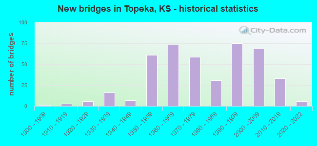
- New bridges - historical statistics
- 11900-1909
- 31910-1919
- 61920-1929
- 161930-1939
- 71940-1949
- 611950-1959
- 731960-1969
- 591970-1979
- 311980-1989
- 751990-1999
- 692000-2009
- 332010-2019
- 62020-2022
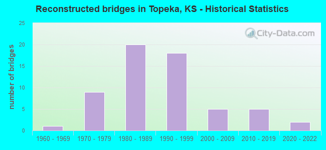
- Reconstructed bridges - Historical Statistics
- 11960-1969
- 91970-1979
- 201980-1989
- 181990-1999
- 52000-2009
- 52010-2019
- 22020-2022
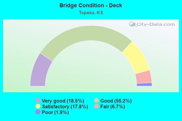
- Bridge Condition - Deck
- 18.5%Very good
- 55.2%Good
- 17.8%Satisfactory
- 6.7%Fair
- 1.9%Poor
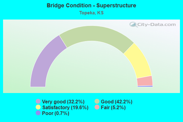
- Bridge Condition - Superstructure
- 32.2%Very good
- 42.2%Good
- 19.6%Satisfactory
- 5.2%Fair
- 0.7%Poor
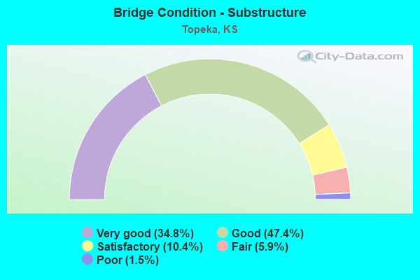
- Bridge Condition - Substructure
- 34.8%Very good
- 47.4%Good
- 10.4%Satisfactory
- 5.9%Fair
- 1.5%Poor
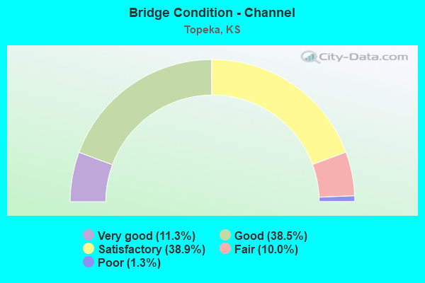
- Bridge Condition - Channel
- 11.3%Very good
- 38.5%Good
- 38.9%Satisfactory
- 10.0%Fair
- 1.3%Poor
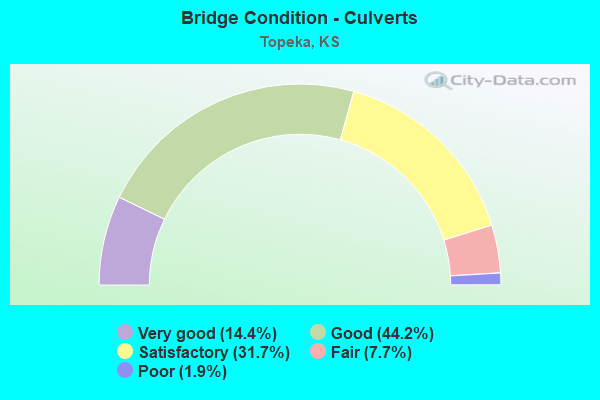
- Bridge Condition - Culverts
- 14.4%Very good
- 44.2%Good
- 31.7%Satisfactory
- 7.7%Fair
- 1.9%Poor
Find on map >> Show street view
Structure Number: 52795089000H14A, Location: 170.08m E. of SE 10th & D (Lat: 39.037006, Lng: -95.635244), Route carried "on" structure: City street , Year Built: 1967, Status: Open, Structure Length: 1.51m (4.95ft), Average Daily Traffic: 525 (year 2019), Truck Traffic: 2%, Average Future Daily Traffic: 622 (year 2043), Design Load: H 20, Features Intersected: Deer Cr., Facility Carried by Structure: SE 10th St.
Minimum Vertical Clearance: 30.47m (99.97ft), Kilometerpoint: 0.000, Lanes on structure: 2, Owner: City or Municipal Highway Agency, Approaching Roadway Width: 8.5m (27.9ft), Material/Design: Concrete, Design/Construction: Culvert, Number Of Spans In Main Unit: 3, Length of Maximum Span: 4.9m (16.1ft), Curb or Sidewalk Widths: Left: 1.6m (5.2ft), Right: 1.6m (5.2ft), Curb-To-Curb Width: 8.5m (27.9ft), Out-to-Out Width: 13.1m (43.0ft)
Condition: Channel: Satisfactory, Culverts: Fair, Operating Rating: 26.8 metric tons, Method Used To Determine Operating Rating: Load Factor (LF), Inventory Rating: 16.0 metric tons, Method Used To Determine Inventory Rating: Load Factor (LF), Structural Evaluation: Meets minimum limits, Deck Geometry: Somewhat better than minimum adequacy, Waterway Adequacy: Better than present minimum criteria, Approach Roadway Alignment: Better than present minimum criteria, Length Of Structure Improvement: 1.52m (4.99ft), Designated Inspection Frequency: Every 24 months, Inspection Date: September 2021
Find on map >> Show street view
Structure Number: 52795089000M10D, Location: 33.53m E. of SE38th & Eva (Lat: 38.997856, Lng: -95.674053), Route carried "on" structure: City street , Year Built: 1980, Status: Open, Structure Length: 0.94m (3.08ft), Average Daily Traffic: 149 (year 2019), Truck Traffic: 1%, Average Future Daily Traffic: 176 (year 2043), Design Load: HS 20, Features Intersected: Butcher Cr., Facility Carried by Structure: SE 38th St.
Minimum Vertical Clearance: 4.57m (14.99ft), Kilometerpoint: 0.000, Lanes on structure: 2, Owner: City or Municipal Highway Agency, Approaching Roadway Width: 8.1m (26.6ft), Material/Design: Concrete, Design/Construction: Culvert, Number Of Spans In Main Unit: 3, Length of Maximum Span: 3.0m (9.8ft), Curb or Sidewalk Widths: Left: 1.2m (3.9ft), Right: 1.2m (3.9ft)
Condition: Channel: Satisfactory, Culverts: Good, Operating Rating: 32.7 metric tons, Method Used To Determine Operating Rating: Load Factor (LF), Inventory Rating: 19.6 metric tons, Method Used To Determine Inventory Rating: Load Factor (LF), Structural Evaluation: Somewhat better than minimum adequacy, Waterway Adequacy: Better than present minimum criteria, Approach Roadway Alignment: Better than present minimum criteria, Length Of Structure Improvement: 0.94m (3.08ft), Designated Inspection Frequency: Every 24 months, Inspection Date: September 2021
Find on map >> Show street view
Structure Number: 52795089000M1AA, Location: 70.15mW SW38th/Stonybrook (Lat: 38.997539, Lng: -95.765039), Route carried "on" structure: City street 2562, Year Built: 2017, Status: Open, Structure Length: 0.66m (2.17ft), Average Daily Traffic: 100 (year 2019), Truck Traffic: 1%, Average Future Daily Traffic: 114 (year 2043), Design Load: HL 93, Features Intersected: trib Shunganunga Creek, Facility Carried by Structure: SW 38th St.
Minimum Vertical Clearance: 30.47m (99.97ft), Kilometerpoint: 0.000, Lanes on structure: 2, Owner: City or Municipal Highway Agency, Approaching Roadway Width: 8.4m (27.6ft), Material/Design: Concrete, Design/Construction: Culvert, Number Of Spans In Main Unit: 2, Length of Maximum Span: 3.0m (9.8ft), Curb or Sidewalk Widths: Left: 1.2m (3.9ft), Right: 1.2m (3.9ft)
Condition: Channel: Good, Culverts: Good, Operating Rating: 47.6 metric tons, Method Used To Determine Operating Rating: Load Factor (LF), Inventory Rating: 28.4 metric tons, Method Used To Determine Inventory Rating: Load Factor (LF), Structural Evaluation: Better than present minimum criteria, Waterway Adequacy: Equal to present desirable criteria, Approach Roadway Alignment: Equal to present desirable criteria, Length Of Structure Improvement: 0.66m (2.17ft), Designated Inspection Frequency: Every 24 months, Inspection Date: September 2021
Find on map >> Show street view
Structure Number: 52795089000N10B, Location: 20 m W of Adams (Lat: 38.989533, Lng: -95.670686), Route carried "on" structure: City street , Year Built: 1978, Status: Open, Structure Length: 0.95m (3.12ft), Average Daily Traffic: 374 (year 2019), Truck Traffic: 1%, Average Future Daily Traffic: 466 (year 2043), Design Load: H 20, Features Intersected: Butcher Cr., Facility Carried by Structure: SW 43rd Terr.
Minimum Vertical Clearance: 30.47m (99.97ft), Kilometerpoint: 0.000, Lanes on structure: 2, Owner: City or Municipal Highway Agency, Approaching Roadway Width: 11.0m (36.1ft), Material/Design: Concrete, Design/Construction: Culvert, Number Of Spans In Main Unit: 3, Length of Maximum Span: 3.0m (9.8ft), Curb or Sidewalk Widths: Left: 1.2m (3.9ft), Right: 1.2m (3.9ft)
Condition: Channel: Satisfactory, Culverts: Satisfactory, Operating Rating: 32.7 metric tons, Method Used To Determine Operating Rating: Load Factor (LF), Inventory Rating: 19.6 metric tons, Method Used To Determine Inventory Rating: Load Factor (LF), Structural Evaluation: Somewhat better than minimum adequacy, Waterway Adequacy: Equal to present minimum criteria, Approach Roadway Alignment: Better than present minimum criteria, Length Of Structure Improvement: 0.96m (3.15ft), Designated Inspection Frequency: Every 24 months, Inspection Date: September 2021
Find on map >> Show street view
Structure Number: 52795089R000D7I, Location: 98.67m E of SW 3rd&Jewell (Lat: 39.060800, Lng: -95.698344), Route carried "on" structure: City street 6698, Year Built: 2019, Status: Open, Structure Length: 0.82m (2.69ft), Average Daily Traffic: 352 (year 2020), Average Future Daily Traffic: 375 (year 2043), Design Load: HL 93, Features Intersected: Ward Creek, Facility Carried by Structure: SW 3rd St.
Minimum Vertical Clearance: 30.47m (99.97ft), Kilometerpoint: 0.000, Lanes on structure: 2, Owner: City or Municipal Highway Agency, Approaching Roadway Width: 7.8m (25.6ft), Material/Design: Concrete, Design/Construction: Culvert, Number Of Spans In Main Unit: 2, Length of Maximum Span: 4.0m (13.1ft), Curb or Sidewalk Widths: Left: 1.5m (4.9ft), Right: 1.5m (4.9ft)
Condition: Channel: Good, Culverts: Good, Inventory Rating: 75.7 metric tons, Method Used To Determine Inventory Rating: Load Factor (LF), Structural Evaluation: Better than present minimum criteria, Waterway Adequacy: Somewhat better than minimum adequacy, Approach Roadway Alignment: Equal to present desirable criteria, Designated Inspection Frequency: Every 24 months, Inspection Date: October 2021
Find on map >> Show street view
Structure Number: 52795089R000D7J, Location: 96.31m E of SW Jewell Ave (Lat: 39.059764, Lng: -95.698164), Route carried "on" structure: City street , Year Built: 2018, Status: Open, Structure Length: 0.69m (2.26ft), Average Daily Traffic: 352 (year 2019), Truck Traffic: 1%, Average Future Daily Traffic: 417 (year 2043), Design Load: HL 93, Features Intersected: Ward Creek, Facility Carried by Structure: SW Cherokee St.
Minimum Vertical Clearance: 30.47m (99.97ft), Kilometerpoint: 0.000, Lanes on structure: 2, Owner: City or Municipal Highway Agency, Approaching Roadway Width: 7.3m (24.0ft), Material/Design: Concrete, Design/Construction: Culvert, Number Of Spans In Main Unit: 2, Length of Maximum Span: 3.4m (11.2ft), Curb or Sidewalk Widths: Left: 0.0m, Right: 1.5m (4.9ft)
Condition: Channel: Good, Culverts: Good, Operating Rating: 90.6 metric tons, Method Used To Determine Operating Rating: Load Factor (LF), Inventory Rating: 66.0 metric tons, Method Used To Determine Inventory Rating: Load Factor (LF), Structural Evaluation: Better than present minimum criteria, Waterway Adequacy: Somewhat better than minimum adequacy, Approach Roadway Alignment: Better than present minimum criteria, Designated Inspection Frequency: Every 24 months, Inspection Date: October 2021
Find on map >> Show street view
Structure Number: 52795089R000O8A, Location: 187.691m W. of SW49th & T (Lat: 38.978833, Lng: -95.690497), Route carried "on" structure: City street , Year Built: 2014, Status: Open, Structure Length: 2.82m (9.25ft), Average Daily Traffic: 500 (year 2019), Truck Traffic: 10%, Average Future Daily Traffic: 586 (year 2043), Design Load: HL 93, Features Intersected: Trib S Shunganunga Crk, Facility Carried by Structure: SW 49th St
Minimum Vertical Clearance: 30.47m (99.97ft), Kilometerpoint: 0.000, Lanes on structure: 2, Owner: City or Municipal Highway Agency, Approaching Roadway Width: 12.1m (39.7ft), Material/Design: Concrete continuous, Design/Construction: Slab, Number Of Spans In Main Unit: 3, Length of Maximum Span: 11.0m (36.1ft), Curb-To-Curb Width: 12.2m (40.0ft), Out-to-Out Width: 12.8m (42.0ft)
Condition: Deck: Very good, Superstructure: Very good, Substructure: Very good, Channel: Good, Operating Rating: 84.2 metric tons, Method Used To Determine Operating Rating: Load Factor (LF), Inventory Rating: 50.3 metric tons, Method Used To Determine Inventory Rating: Load Factor (LF), Structural Evaluation: Equal to present desirable criteria, Deck Geometry: Equal to present desirable criteria, Waterway Adequacy: Better than present minimum criteria, Approach Roadway Alignment: Equal to present desirable criteria, Length Of Structure Improvement: 2.83m (9.28ft), Designated Inspection Frequency: Every 24 months, Inspection Date: October 2021, Bridge Improvement Cost: $1,000, Total Project Cost: $1,000 ( Estimate for 2022), Deck Structure Type: Concrete Cast-file-Place, Wearing Surface/Protective System: Wearing Surface: Monolithic Concrete, Deck Protection: Epoxy Coated Reinforcing
Find on map >> Show street view
Structure Number: 52795089R00E1AA, Location: 752.00m W. of SW10th & W_ (Lat: 39.050769, Lng: -95.769264), Route carried "on" structure: City street 5330, Year Built: 2014, Status: Open, Structure Length: 0.74m (2.43ft), Average Daily Traffic: 8,200 (year 2019), Truck Traffic: 5%, Average Future Daily Traffic: 9,615 (year 2043), Design Load: HS 20, Features Intersected: Wanamaker Channel Trib, Facility Carried by Structure: SW 10th St
Minimum Vertical Clearance: 30.47m (99.97ft), Kilometerpoint: 0.000, Lanes on structure: 2, Owner: City or Municipal Highway Agency, Approaching Roadway Width: 7.3m (24.0ft), Material/Design: Concrete, Design/Construction: Culvert, Number Of Spans In Main Unit: 1, Length of Maximum Span: 7.4m (24.3ft)
Condition: Channel: Good, Culverts: Very good, Operating Rating: 76.0 metric tons, Method Used To Determine Operating Rating: Load Factor (LF), Inventory Rating: 45.4 metric tons, Method Used To Determine Inventory Rating: Load Factor (LF), Structural Evaluation: Equal to present desirable criteria, Waterway Adequacy: Better than present minimum criteria, Approach Roadway Alignment: Equal to present desirable criteria, Length Of Structure Improvement: 0.79m (2.59ft), Designated Inspection Frequency: Every 24 months, Inspection Date: September 2021
Find on map >> Show street view
Structure Number: 999900400891641, Location: 7.28 MI NE WAB. CO. LINE (Lat: 39.016944, Lng: -95.867222), Route carried "on" structure: State highway 4, Year Built: 1985, Status: Open, Structure Length: 6.17m (20.24ft), Average Daily Traffic: 380 (year 2020), Truck Traffic: 12%, Average Future Daily Traffic: 464 (year 2041), Design Load: HS 20, Features Intersected: MISSION CREEK
Minimum Vertical Clearance: 30.47m (99.97ft), Kilometerpoint: 11.745, Lanes on structure: 2, Owner: State Highway Agency, Approaching Roadway Width: 8.5m (27.9ft), Skew: 1 degrees, Material/Design: Concrete continuous, Design/Construction: Slab, Number Of Spans In Main Unit: 4, Length of Maximum Span: 19.5m (64.0ft), Curb-To-Curb Width: 11.0m (36.1ft), Out-to-Out Width: 11.6m (38.1ft)
Condition: Deck: Good, Superstructure: Good, Substructure: Good, Channel: Good, Operating Rating: 75.3 metric tons, Method Used To Determine Operating Rating: Load Factor (LF), Inventory Rating: 44.5 metric tons, Method Used To Determine Inventory Rating: Load Factor (LF), Structural Evaluation: Better than present minimum criteria, Deck Geometry: Equal to present desirable criteria, Waterway Adequacy: Equal to present desirable criteria, Approach Roadway Alignment: Meets minimum limits, Length Of Structure Improvement: 20.26m (66.47ft), Designated Inspection Frequency: Every 24 months, Inspection Date: May 2020, Wearing Surface/Protective System: Wearing Surface: Monolithic Concrete, Deck Protection: Epoxy Coated Reinforcing
Find on map >> Show street view
Structure Number: 999900400892301, Location: 0.51 MI N OF US40/K4 NJCT (Lat: 39.051389, Lng: -95.603611), Route carried "on" structure: State highway 4, Year Built: 1998, Status: Open, Structure Length: 6.48m (21.26ft), Average Daily Traffic: 9,395 (year 2020), Truck Traffic: 10%, Average Future Daily Traffic: 13,960 (year 2041), Design Load: HS 25 or greater, Features Intersected: S.E. 2ND AVENUE
Minimum Vertical Clearance: 30.47m (99.97ft), Kilometerpoint: 42.586, Lanes on structure: 2, Lanes under structure: 2, Base Highway Network: Yes, Owner: State Highway Agency, Approaching Roadway Width: 12.2m (40.0ft), Skew: 1 degrees, Material/Design: Prestressed concrete continuous, Design/Construction: Stringer/Multi-beam, Number Of Spans In Main Unit: 3, Length of Maximum Span: 21.3m (69.9ft), Curb-To-Curb Width: 12.2m (40.0ft), Out-to-Out Width: 12.8m (42.0ft)
Condition: Deck: Very good, Superstructure: Very good, Substructure: Very good, Operating Rating: 89.8 metric tons, Method Used To Determine Operating Rating: Load Factor (LF), Inventory Rating: 57.9 metric tons, Method Used To Determine Inventory Rating: Load Factor (LF), Structural Evaluation: Equal to present desirable criteria, Deck Geometry: Somewhat better than minimum adequacy, Underclear: Better than present minimum criteria, Approach Roadway Alignment: Meets minimum limits, Length Of Structure Improvement: 21.27m (69.78ft), Designated Inspection Frequency: Every 24 months, Inspection Date: April 2020, Deck Structure Type: Concrete Precast Panels, Wearing Surface/Protective System: Wearing Surface: Low Slump Concrete, Deck Protection: Epoxy Coated Reinforcing
Find on map >> Show street view
Structure Number: 999900400892311, Location: 0.71 MI N OF US40/K4 NJCT (Lat: 39.053611, Lng: -95.604444), Route carried "on" structure: State highway 4, Year Built: 1998, Status: Open, Structure Length: 37.52m (123.10ft), Average Daily Traffic: 9,395 (year 2020), Truck Traffic: 10%, Average Future Daily Traffic: 13,960 (year 2041), Design Load: HS 25 or greater, Features Intersected: SHUNGANUNGA CR & RR
Minimum Vertical Clearance: 30.47m (99.97ft), Kilometerpoint: 42.886, Lanes on structure: 2, Base Highway Network: Yes, Owner: State Highway Agency, Approaching Roadway Width: 12.2m (40.0ft), Skew: 2 degrees, Material/Design: Prestressed concrete continuous, Design/Construction: Stringer/Multi-beam, Number Of Spans In Main Unit: 13, Length of Maximum Span: 30.5m (100.1ft), Curb-To-Curb Width: 12.2m (40.0ft), Out-to-Out Width: 12.8m (42.0ft)
Condition: Deck: Good, Superstructure: Very good, Substructure: Very good, Channel: Very good, Operating Rating: 89.8 metric tons, Method Used To Determine Operating Rating: Load Factor (LF), Inventory Rating: 48.7 metric tons, Method Used To Determine Inventory Rating: Load Factor (LF), Structural Evaluation: Equal to present desirable criteria, Deck Geometry: Somewhat better than minimum adequacy, Underclear: Superior to present desirable criteria, Waterway Adequacy: Equal to present desirable criteria, Approach Roadway Alignment: Equal to present desirable criteria, Length Of Structure Improvement: 123.08m (403.81ft), Designated Inspection Frequency: Every 24 months, Inspection Date: April 2020, Deck Structure Type: Concrete Precast Panels, Wearing Surface/Protective System: Wearing Surface: Low Slump Concrete, Deck Protection: Epoxy Coated Reinforcing
Find on map >> Show street view
Structure Number: 999900400892321, Location: 1.04 MI N OF US40/K4 NJCT (Lat: 39.058611, Lng: -95.606389), Route carried "on" structure: State highway 4, Year Built: 1998, Status: Open, Structure Length: 6.18m (20.28ft), Average Daily Traffic: 9,395 (year 2020), Truck Traffic: 10%, Average Future Daily Traffic: 13,960 (year 2041), Design Load: HS 25 or greater, Features Intersected: SEWARD AVENUE
Minimum Vertical Clearance: 30.47m (99.97ft), Kilometerpoint: 43.430, Lanes on structure: 3, Lanes under structure: 2, Base Highway Network: Yes, Owner: State Highway Agency, Approaching Roadway Width: 12.2m (40.0ft), Skew: 1 degrees, Material/Design: Prestressed concrete continuous, Design/Construction: Stringer/Multi-beam, Number Of Spans In Main Unit: 3, Length of Maximum Span: 23.2m (76.1ft), Curb-To-Curb Width: 15.8m (51.8ft), Out-to-Out Width: 16.5m (54.1ft)
Condition: Deck: Good, Superstructure: Very good, Substructure: Good, Operating Rating: 89.8 metric tons, Method Used To Determine Operating Rating: Load Factor (LF), Inventory Rating: 54.8 metric tons, Method Used To Determine Inventory Rating: Load Factor (LF), Structural Evaluation: Better than present minimum criteria, Deck Geometry: Somewhat better than minimum adequacy, Underclear: Better than present minimum criteria, Approach Roadway Alignment: Meets minimum limits, Length Of Structure Improvement: 20.27m (66.50ft), Designated Inspection Frequency: Every 24 months, Inspection Date: May 2020, Deck Structure Type: Concrete Precast Panels, Wearing Surface/Protective System: Wearing Surface: Low Slump Concrete, Deck Protection: Epoxy Coated Reinforcing
Find on map >> Show street view
Structure Number: 999900400892331, Location: 2.80 MI N OF US-40/K4 JCT (Lat: 39.080833, Lng: -95.613611), Route carried "on" structure: State highway 4, Year Built: 1998, Status: Open, Structure Length: 168.69m (553.44ft), Average Daily Traffic: 8,612 (year 2020), Truck Traffic: 7%, Average Future Daily Traffic: 12,797 (year 2041), Design Load: HS 25 or greater, Features Intersected: KS RIV/RR/CALHOLN BLUF
Minimum Vertical Clearance: 30.47m (99.97ft), Kilometerpoint: 46.426, Lanes on structure: 2, Lanes under structure: 2, Base Highway Network: Yes, Owner: State Highway Agency, Approaching Roadway Width: 12.2m (40.0ft), Skew: 1 degrees, Material/Design: Steel continuous, Design/Construction: Stringer/Multi-beam, Number Of Spans In Main Unit: 31, Length of Maximum Span: 70.7m (232.0ft), Curb-To-Curb Width: 12.2m (40.0ft), Out-to-Out Width: 12.8m (42.0ft)
Condition: Deck: Good, Superstructure: Good, Substructure: Good, Channel: Satisfactory, Operating Rating: 53.5 metric tons, Method Used To Determine Operating Rating: Load Factor (LF), Inventory Rating: 32.1 metric tons, Method Used To Determine Inventory Rating: Load Factor (LF), Structural Evaluation: Better than present minimum criteria, Deck Geometry: Somewhat better than minimum adequacy, Underclear: Equal to present minimum criteria, Waterway Adequacy: Better than present minimum criteria, Approach Roadway Alignment: Meets minimum limits, Length Of Structure Improvement: 553.45m (1815.78ft), Designated Inspection Frequency: Every 24 months, Inspection Date: April 2020, Wearing Surface/Protective System: Wearing Surface: Epoxy Overlay, Deck Protection: Epoxy Coated Reinforcing
Find on map >> Show street view
Structure Number: 999900400892611, Location: EJCT U40/K4 (Lat: 39.044167, Lng: -95.601944), Route carried "on" structure: US 40, Year Built: 2000, Status: Open, Structure Length: 7.71m (25.30ft), Average Daily Traffic: 1,290 (year 2020), Truck Traffic: 13%, Average Future Daily Traffic: 1,917 (year 2041), Design Load: HS 25 or greater, Features Intersected: US-40 HWY, Facility Carried by Structure: K-4 HWY WB
Minimum Vertical Clearance: 30.47m (99.97ft), Kilometerpoint: 33.494, Lanes on structure: 2, Lanes under structure: 5, Base Highway Network: Yes, Owner: State Highway Agency, Approaching Roadway Width: 11.6m (38.1ft), Skew: 1 degrees, Material/Design: Steel continuous, Design/Construction: Stringer/Multi-beam, Number Of Spans In Main Unit: 3, Length of Maximum Span: 38.4m (126.0ft), Curb-To-Curb Width: 15.2m (49.9ft), Out-to-Out Width: 16.0m (52.5ft)
Condition: Deck: Good, Superstructure: Good, Substructure: Good, Inventory Rating: 68.0 metric tons, Method Used To Determine Inventory Rating: Load Factor (LF), Structural Evaluation: Better than present minimum criteria, Deck Geometry: Superior to present desirable criteria, Underclear: Better than present minimum criteria, Approach Roadway Alignment: Equal to present desirable criteria, Length Of Structure Improvement: 25.31m (83.04ft), Designated Inspection Frequency: Every 24 months, Inspection Date: April 2020, Wearing Surface/Protective System: Wearing Surface: Low Slump Concrete, Deck Protection: Epoxy Coated Reinforcing
Find on map >> Show street view
Structure Number: 999900400892621, Location: EJCT U40/K4 (Lat: 39.044167, Lng: -95.601667), Route carried "on" structure: US 40, Year Built: 2000, Status: Open, Structure Length: 7.71m (25.30ft), Average Daily Traffic: 1,290 (year 2020), Truck Traffic: 13%, Average Future Daily Traffic: 1,917 (year 2041), Design Load: HS 25 or greater, Features Intersected: US-40 HWY, Facility Carried by Structure: K-4 HWY EB
Minimum Vertical Clearance: 30.47m (99.97ft), Kilometerpoint: 33.722, Lanes on structure: 3, Lanes under structure: 5, Base Highway Network: Yes, Owner: State Highway Agency, Approaching Roadway Width: 15.2m (49.9ft), Skew: 1 degrees, Material/Design: Steel continuous, Design/Construction: Stringer/Multi-beam, Number Of Spans In Main Unit: 3, Length of Maximum Span: 38.4m (126.0ft), Curb-To-Curb Width: 15.2m (49.9ft), Out-to-Out Width: 16.0m (52.5ft)
Condition: Deck: Good, Superstructure: Very good, Substructure: Very good, Inventory Rating: 68.0 metric tons, Method Used To Determine Inventory Rating: Load Factor (LF), Structural Evaluation: Equal to present desirable criteria, Deck Geometry: Meets minimum limits, Underclear: Better than present minimum criteria, Approach Roadway Alignment: Somewhat better than minimum adequacy, Length Of Structure Improvement: 25.28m (82.94ft), Designated Inspection Frequency: Every 24 months, Inspection Date: April 2020, Wearing Surface/Protective System: Wearing Surface: Low Slump Concrete, Deck Protection: Epoxy Coated Reinforcing
Find on map >> Show street view
Structure Number: 999900400893001, Location: 8.90 MI NE WABAUNSEE COLN (Lat: 39.021667, Lng: -95.839167), Route carried "on" structure: State highway 4, Year Built: 2016, Status: Open, Structure Length: 3.57m (11.71ft), Average Daily Traffic: 1,180 (year 2020), Truck Traffic: 7%, Average Future Daily Traffic: 1,440 (year 2041), Design Load: HL 93, Features Intersected: BLACKSMITH CREEK
Minimum Vertical Clearance: 30.47m (99.97ft), Kilometerpoint: 14.339, Lanes on structure: 2, Owner: State Highway Agency, Approaching Roadway Width: 7.9m (25.9ft), Skew: 4 degrees, Material/Design: Steel, Design/Construction: Stringer/Multi-beam, Number Of Spans In Main Unit: 1, Length of Maximum Span: 34.1m (111.9ft), Curb-To-Curb Width: 12.2m (40.0ft), Out-to-Out Width: 12.8m (42.0ft)
Condition: Deck: Good, Superstructure: Very good, Substructure: Very good, Channel: Very good, Operating Rating: 59.0 metric tons, Method Used To Determine Operating Rating: Load and Resistance Factor Rating (LRFR) rating reported by rating factor(RF) method using HL-93 loadings, Inventory Rating: 45.4 metric tons, Method Used To Determine Inventory Rating: Load and Resistance Factor Rating (LRFR) rating reported by rating factor(RF) method using HL-93 loadings, Structural Evaluation: Equal to present desirable criteria, Deck Geometry: Better than present minimum criteria, Waterway Adequacy: Equal to present desirable criteria, Approach Roadway Alignment: Better than present minimum criteria, Length Of Structure Improvement: 11.70m (38.39ft), Designated Inspection Frequency: Every 24 months, Inspection Date: May 2020, Wearing Surface/Protective System: Wearing Surface: Monolithic Concrete, Deck Protection: Epoxy Coated Reinforcing
Find on map >> Show street view
Structure Number: 999902400890751, Location: 0.84 MI E JCT US75 (Lat: 39.090556, Lng: -95.711944), Route carried "on" structure: US 24, Year Built: 1956, Status: Open, Structure Length: 0.85m (2.79ft), Average Daily Traffic: 8,081 (year 2020), Truck Traffic: 9%, Average Future Daily Traffic: 9,860 (year 2041), Design Load: H 20, Features Intersected: FURMAN ROAD
Minimum Vertical Clearance: 30.47m (99.97ft), Kilometerpoint: 31.501, Lanes on structure: 4, Lanes under structure: 2, Base Highway Network: Yes, Owner: State Highway Agency, Approaching Roadway Width: 24.4m (80.1ft), Skew: 20 degrees, Material/Design: Concrete, Design/Construction: Culvert, Number Of Spans In Main Unit: 1, Length of Maximum Span: 8.5m (27.9ft), Curb-To-Curb Width: 24.4m (80.1ft), Out-to-Out Width: 33.5m (109.9ft)
Condition: Culverts: Fair, Operating Rating: 30.4 metric tons, Method Used To Determine Operating Rating: Load Factor (LF), Inventory Rating: 18.2 metric tons, Method Used To Determine Inventory Rating: Load Factor (LF), Structural Evaluation: Meets minimum limits, Deck Geometry: Superior to present desirable criteria, Underclear: High priority of corrective action, Approach Roadway Alignment: Equal to present desirable criteria, Length Of Structure Improvement: 3.22m (10.56ft), Designated Inspection Frequency: Every 24 months, Inspection Date: April 2020, Deck Structure Type: Concrete Cast-file-Place, Wearing Surface/Protective System: Wearing Surface: Bituminous
Find on map >> Show street view
Structure Number: 999902400890761, Location: 1.67 MI E JCT US75 WB (Lat: 39.090833, Lng: -95.696667), Route carried "on" structure: US 24, Year Built: 1956, Status: Open, Structure Length: 4.53m (14.86ft), Average Daily Traffic: 8,081 (year 2020), Truck Traffic: 9%, Average Future Daily Traffic: 9,860 (year 2041), Design Load: HS 20, Features Intersected: GOODYEAR PLANT ENTRANCE
Minimum Vertical Clearance: 30.47m (99.97ft), Kilometerpoint: 32.816, Lanes on structure: 2, Lanes under structure: 2, Base Highway Network: Yes, Owner: State Highway Agency, Approaching Roadway Width: 12.2m (40.0ft), Material/Design: Concrete continuous, Design/Construction: Slab, Number Of Spans In Main Unit: 3, Length of Maximum Span: 18.9m (62.0ft), Curb-To-Curb Width: 8.5m (27.9ft), Out-to-Out Width: 8.9m (29.2ft)
Condition: Deck: Satisfactory, Superstructure: Satisfactory, Substructure: Good, Operating Rating: 62.6 metric tons, Method Used To Determine Operating Rating: Load Factor (LF), Inventory Rating: 37.2 metric tons, Method Used To Determine Inventory Rating: Load Factor (LF), Structural Evaluation: Equal to present minimum criteria, Deck Geometry: High priority of replacement, Underclear: Meets minimum limits, Approach Roadway Alignment: Equal to present minimum criteria, Length Of Structure Improvement: 14.85m (48.72ft), Designated Inspection Frequency: Every 24 months, Inspection Date: April 2020, Deck Structure Type: Concrete Cast-file-Place, Wearing Surface/Protective System: Wearing Surface: Low Slump Concrete
Find on map >> Show street view
Structure Number: 999902400890771, Location: 1.25 MI E JCT US75 EB (Lat: 39.090556, Lng: -95.696667), Route carried "on" structure: US 24, Year Built: 1956, Status: Open, Structure Length: 4.53m (14.86ft), Average Daily Traffic: 8,081 (year 2020), Truck Traffic: 9%, Average Future Daily Traffic: 9,860 (year 2041), Design Load: HS 20, Features Intersected: GOODYEAR PLANT ENTRANCE
Minimum Vertical Clearance: 30.47m (99.97ft), Kilometerpoint: 32.824, Lanes on structure: 2, Lanes under structure: 2, Base Highway Network: Yes, Owner: State Highway Agency, Approaching Roadway Width: 12.2m (40.0ft), Material/Design: Concrete continuous, Design/Construction: Slab, Number Of Spans In Main Unit: 3, Length of Maximum Span: 18.9m (62.0ft), Curb-To-Curb Width: 8.5m (27.9ft), Out-to-Out Width: 10.3m (33.8ft)
Condition: Deck: Good, Superstructure: Good, Substructure: Good, Operating Rating: 63.5 metric tons, Method Used To Determine Operating Rating: Load Factor (LF), Inventory Rating: 38.1 metric tons, Method Used To Determine Inventory Rating: Load Factor (LF), Structural Evaluation: Better than present minimum criteria, Deck Geometry: High priority of replacement, Underclear: Meets minimum limits, Approach Roadway Alignment: Equal to present minimum criteria, Length Of Structure Improvement: 14.85m (48.72ft), Designated Inspection Frequency: Every 24 months, Inspection Date: April 2020, Deck Structure Type: Concrete Cast-file-Place, Wearing Surface/Protective System: Wearing Surface: Low Slump Concrete
Find on map >> Show street view
Structure Number: 999902400890824, Location: 1.56 MI E TOPEKA AVE, WB (Lat: 39.091111, Lng: -95.635278), Route carried "on" structure: US 24, Year Built: 1936, Status: Open, Structure Length: 5.07m (16.63ft), Average Daily Traffic: 6,363 (year 2020), Truck Traffic: 10%, Average Future Daily Traffic: 7,462 (year 2041), Design Load: H 15, Features Intersected: ABANDONED RR
Minimum Vertical Clearance: 30.47m (99.97ft), Kilometerpoint: 38.117, Lanes on structure: 2, Base Highway Network: Yes, Owner: State Highway Agency, Approaching Roadway Width: 12.8m (42.0ft), Skew: 3 degrees, Material/Design: Concrete continuous, Design/Construction: Slab, Number Of Spans In Main Unit: 5, Length of Maximum Span: 10.7m (35.1ft), Curb-To-Curb Width: 12.8m (42.0ft), Out-to-Out Width: 14.0m (45.9ft)
Condition: Deck: Good, Superstructure: Satisfactory, Substructure: Good, Operating Rating: 56.7 metric tons, Method Used To Determine Operating Rating: Load Factor (LF), Inventory Rating: 33.9 metric tons, Method Used To Determine Inventory Rating: Load Factor (LF), Structural Evaluation: Equal to present minimum criteria, Deck Geometry: Equal to present desirable criteria, Underclear: Somewhat better than minimum adequacy, Approach Roadway Alignment: Equal to present desirable criteria, Length Of Structure Improvement: 16.64m (54.59ft), Designated Inspection Frequency: Every 24 months, Inspection Date: April 2020, Deck Structure Type: Concrete Cast-file-Place, Wearing Surface/Protective System: Wearing Surface: Low Slump Concrete
Find on map >> Show street view
Structure Number: 999902400890831, Location: 1.55 MI E TOPEKA AVE, EB (Lat: 39.090833, Lng: -95.635556), Route carried "on" structure: US 24, Year Built: 1959, Status: Open, Structure Length: 5.70m (18.70ft), Average Daily Traffic: 6,363 (year 2020), Truck Traffic: 10%, Average Future Daily Traffic: 7,462 (year 2041), Design Load: HS 20, Features Intersected: ABANDONED RR
Minimum Vertical Clearance: 30.47m (99.97ft), Kilometerpoint: 38.112, Lanes on structure: 2, Base Highway Network: Yes, Owner: State Highway Agency, Approaching Roadway Width: 12.2m (40.0ft), Skew: 3 degrees, Material/Design: Concrete continuous, Design/Construction: Slab, Number Of Spans In Main Unit: 5, Length of Maximum Span: 12.2m (40.0ft), Curb-To-Curb Width: 12.2m (40.0ft), Out-to-Out Width: 12.7m (41.7ft)
Condition: Deck: Fair, Superstructure: Satisfactory, Substructure: Satisfactory, Operating Rating: 33.6 metric tons, Method Used To Determine Operating Rating: Load Factor (LF), Inventory Rating: 20.0 metric tons, Method Used To Determine Inventory Rating: Load Factor (LF), Structural Evaluation: Somewhat better than minimum adequacy, Deck Geometry: Better than present minimum criteria, Underclear: Equal to present minimum criteria, Approach Roadway Alignment: Equal to present desirable criteria, Length Of Structure Improvement: 18.71m (61.38ft), Designated Inspection Frequency: Every 24 months, Inspection Date: April 2020, Deck Structure Type: Concrete Cast-file-Place, Wearing Surface/Protective System: Wearing Surface: Low Slump Concrete
Find on map >> Show street view
Structure Number: 999902400890844, Location: 1.96 MI E TOPEKA AVE, WB (Lat: 39.091111, Lng: -95.628333), Route carried "on" structure: US 24, Year Built: 1958, Status: Open, Structure Length: 7.33m (24.05ft), Average Daily Traffic: 6,363 (year 2020), Truck Traffic: 10%, Average Future Daily Traffic: 7,462 (year 2041), Design Load: HS 20, Features Intersected: SOLDIER CR NEW CHAN
Minimum Vertical Clearance: 30.47m (99.97ft), Kilometerpoint: 38.732, Lanes on structure: 2, Base Highway Network: Yes, Owner: State Highway Agency, Approaching Roadway Width: 12.2m (40.0ft), Material/Design: Concrete continuous, Design/Construction: Tee Beam, Number Of Spans In Main Unit: 3, Length of Maximum Span: 29.9m (98.1ft), Curb-To-Curb Width: 8.5m (27.9ft), Out-to-Out Width: 10.2m (33.5ft)
Condition: Deck: Good, Superstructure: Good, Substructure: Good, Channel: Good, Operating Rating: 66.3 metric tons, Method Used To Determine Operating Rating: Load Factor (LF), Inventory Rating: 40.5 metric tons, Method Used To Determine Inventory Rating: Load Factor (LF), Structural Evaluation: Better than present minimum criteria, Deck Geometry: High priority of corrective action, Waterway Adequacy: Meets minimum limits, Approach Roadway Alignment: Equal to present minimum criteria, Length Of Structure Improvement: 24.05m (78.90ft), Designated Inspection Frequency: Every 24 months, Inspection Date: April 2020, Deck Structure Type: Concrete Cast-file-Place, Wearing Surface/Protective System: Wearing Surface: Low Slump Concrete
Find on map >> Show street view
Structure Number: 999902400890854, Location: 1.95 MI E TOPEKA AVE, EB (Lat: 39.090833, Lng: -95.628333), Route carried "on" structure: US 24, Year Built: 1958, Status: Open, Structure Length: 7.33m (24.05ft), Average Daily Traffic: 6,363 (year 2020), Truck Traffic: 10%, Average Future Daily Traffic: 7,462 (year 2041), Design Load: HS 20, Features Intersected: SOLDIER CR NEW CHAN
Minimum Vertical Clearance: 30.47m (99.97ft), Kilometerpoint: 38.739, Lanes on structure: 2, Base Highway Network: Yes, Owner: State Highway Agency, Approaching Roadway Width: 12.2m (40.0ft), Material/Design: Concrete continuous, Design/Construction: Tee Beam, Number Of Spans In Main Unit: 3, Length of Maximum Span: 29.9m (98.1ft), Curb-To-Curb Width: 8.5m (27.9ft), Out-to-Out Width: 10.2m (33.5ft)
Condition: Deck: Satisfactory, Superstructure: Good, Substructure: Good, Channel: Good, Operating Rating: 66.3 metric tons, Method Used To Determine Operating Rating: Load Factor (LF), Inventory Rating: 40.5 metric tons, Method Used To Determine Inventory Rating: Load Factor (LF), Structural Evaluation: Better than present minimum criteria, Deck Geometry: High priority of corrective action, Waterway Adequacy: Meets minimum limits, Approach Roadway Alignment: Equal to present minimum criteria, Length Of Structure Improvement: 24.05m (78.90ft), Designated Inspection Frequency: Every 24 months, Inspection Date: April 2020, Deck Structure Type: Concrete Cast-file-Place, Wearing Surface/Protective System: Wearing Surface: Low Slump Concrete
Find on map >> Show street view
Structure Number: 999902400891041, Location: E JCT US24/OLD US75 (Lat: 39.090556, Lng: -95.719722), Route carried "on" structure: ServiceCity street 1935, Year Built: 1963, Status: Open, Structure Length: 6.58m (21.59ft), Average Daily Traffic: 421 (year 2020), Truck Traffic: 1%, Average Future Daily Traffic: 9,762 (year 2041), Design Load: HS 20, Features Intersected: US24 HWY, Facility Carried by Structure: OLD US 75 HWY SB
Minimum Vertical Clearance: 30.47m (99.97ft), Kilometerpoint: 0.439, Lanes on structure: 1, Lanes under structure: 4, Owner: State Highway Agency, Approaching Roadway Width: 6.7m (22.0ft), Material/Design: Steel continuous, Design/Construction: Stringer/Multi-beam, Number Of Spans In Main Unit: 4, Length of Maximum Span: 20.1m (65.9ft), Curb-To-Curb Width: 6.7m (22.0ft), Out-to-Out Width: 7.1m (23.3ft)
Condition: Deck: Satisfactory, Superstructure: Satisfactory, Substructure: Satisfactory, Operating Rating: 43.5 metric tons, Method Used To Determine Operating Rating: Load Factor (LF), Inventory Rating: 26.3 metric tons, Method Used To Determine Inventory Rating: Load Factor (LF), Structural Evaluation: Equal to present minimum criteria, Deck Geometry: Meets minimum limits, Underclear: High priority of corrective action, Approach Roadway Alignment: Somewhat better than minimum adequacy, Length Of Structure Improvement: 21.60m (70.87ft), Designated Inspection Frequency: Every 12 months, Critical Feature Inspection Frequency: Every 24 months, Inspection Date: August 2021, Critical Feature Inspection Date: June 2020, Deck Structure Type: Concrete Cast-file-Place, Wearing Surface/Protective System: Wearing Surface: Low Slump Concrete
Find on map >> Show street view
Structure Number: 999902400891051, Location: E JCT US24/OLD US75 (Lat: 39.090556, Lng: -95.719444), Route carried "on" structure: ServiceCity street 1935, Year Built: 1963, Status: Open, Structure Length: 6.58m (21.59ft), Average Daily Traffic: 421 (year 2020), Truck Traffic: 1%, Average Future Daily Traffic: 9,762 (year 2041), Design Load: HS 20, Features Intersected: US24HWY, Facility Carried by Structure: OLD US 75 HWY NB
Minimum Vertical Clearance: 30.47m (99.97ft), Kilometerpoint: 0.183, Lanes on structure: 1, Lanes under structure: 5, Owner: State Highway Agency, Approaching Roadway Width: 6.7m (22.0ft), Material/Design: Steel continuous, Design/Construction: Stringer/Multi-beam, Number Of Spans In Main Unit: 4, Length of Maximum Span: 20.1m (65.9ft), Curb-To-Curb Width: 6.7m (22.0ft), Out-to-Out Width: 7.1m (23.3ft)
Condition: Deck: Satisfactory, Superstructure: Satisfactory, Substructure: Satisfactory, Operating Rating: 42.6 metric tons, Method Used To Determine Operating Rating: Load Factor (LF), Inventory Rating: 25.4 metric tons, Method Used To Determine Inventory Rating: Load Factor (LF), Structural Evaluation: Equal to present minimum criteria, Deck Geometry: Meets minimum limits, Underclear: High priority of corrective action, Approach Roadway Alignment: Somewhat better than minimum adequacy, Length Of Structure Improvement: 21.60m (70.87ft), Designated Inspection Frequency: Every 12 months, Critical Feature Inspection Frequency: Every 24 months, Inspection Date: August 2021, Critical Feature Inspection Date: July 2020, Deck Structure Type: Concrete Cast-file-Place, Wearing Surface/Protective System: Wearing Surface: Low Slump Concrete
Find on map >> Show street view
Structure Number: 999902400891791, Location: 1.84 MI E JCT US75 WB (Lat: 39.090833, Lng: -95.685556), Route carried "on" structure: US 24, Year Built: 1990, Status: Open, Structure Length: 5.59m (18.34ft), Average Daily Traffic: 8,586 (year 2020), Truck Traffic: 9%, Average Future Daily Traffic: 10,477 (year 2041), Design Load: HS 20, Features Intersected: UP RAILROAD
Minimum Vertical Clearance: 30.47m (99.97ft), Kilometerpoint: 33.774, Lanes on structure: 2, Base Highway Network: Yes, Owner: State Highway Agency, Approaching Roadway Width: 12.2m (40.0ft), Skew: 2 degrees, Material/Design: Steel continuous, Design/Construction: Stringer/Multi-beam, Number Of Spans In Main Unit: 3, Length of Maximum Span: 21.3m (69.9ft), Curb-To-Curb Width: 12.2m (40.0ft), Out-to-Out Width: 12.8m (42.0ft)
Condition: Deck: Good, Superstructure: Very good, Substructure: Good, Operating Rating: 64.7 metric tons, Method Used To Determine Operating Rating: Load Factor (LF), Inventory Rating: 38.7 metric tons, Method Used To Determine Inventory Rating: Load Factor (LF), Structural Evaluation: Better than present minimum criteria, Deck Geometry: Better than present minimum criteria, Underclear: Better than present minimum criteria, Approach Roadway Alignment: Equal to present desirable criteria, Length Of Structure Improvement: 18.34m (60.17ft), Designated Inspection Frequency: Every 24 months, Inspection Date: April 2020, Wearing Surface/Protective System: Wearing Surface: Low Slump Concrete, Deck Protection: Epoxy Coated Reinforcing
Find on map >> Show street view
Structure Number: 999902400891801, Location: 1.85 MI E JCT US75 EB (Lat: 39.090833, Lng: -95.685278), Route carried "on" structure: US 24, Year Built: 1990, Status: Open, Structure Length: 5.59m (18.34ft), Average Daily Traffic: 8,586 (year 2020), Truck Traffic: 9%, Average Future Daily Traffic: 10,477 (year 2041), Design Load: HS 20, Features Intersected: UP RAILROAD
Minimum Vertical Clearance: 30.47m (99.97ft), Kilometerpoint: 33.793, Lanes on structure: 2, Base Highway Network: Yes, Owner: State Highway Agency, Approaching Roadway Width: 12.2m (40.0ft), Skew: 2 degrees, Material/Design: Steel continuous, Design/Construction: Stringer/Multi-beam, Number Of Spans In Main Unit: 3, Length of Maximum Span: 21.3m (69.9ft), Curb-To-Curb Width: 12.2m (40.0ft), Out-to-Out Width: 12.8m (42.0ft)
Condition: Deck: Good, Superstructure: Very good, Substructure: Very good, Operating Rating: 47.2 metric tons, Method Used To Determine Operating Rating: Load Factor (LF), Inventory Rating: 28.1 metric tons, Method Used To Determine Inventory Rating: Load Factor (LF), Structural Evaluation: Better than present minimum criteria, Deck Geometry: Better than present minimum criteria, Underclear: Better than present minimum criteria, Approach Roadway Alignment: Equal to present desirable criteria, Length Of Structure Improvement: 18.34m (60.17ft), Designated Inspection Frequency: Every 24 months, Inspection Date: April 2020, Wearing Surface/Protective System: Wearing Surface: Low Slump Concrete, Deck Protection: Epoxy Coated Reinforcing
Find on map >> Show street view
Structure Number: 999902400892341, Location: US-24/K4 INTERCHANGE, EB (Lat: 39.093333, Lng: -95.607778), Route carried "on" structure: US 24, Year Built: 1996, Status: Open, Structure Length: 11.59m (38.02ft), Average Daily Traffic: 6,363 (year 2020), Truck Traffic: 10%, Average Future Daily Traffic: 7,462 (year 2041), Design Load: HS 25 or greater, Features Intersected: K-4 HWY
Minimum Vertical Clearance: 30.47m (99.97ft), Kilometerpoint: 40.557, Lanes on structure: 2, Lanes under structure: 2, Base Highway Network: Yes, Owner: State Highway Agency, Approaching Roadway Width: 11.0m (36.1ft), Skew: 2 degrees, Material/Design: Steel continuous, Design/Construction: Stringer/Multi-beam, Number Of Spans In Main Unit: 4, Length of Maximum Span: 40.2m (131.9ft), Curb-To-Curb Width: 15.2m (49.9ft), Out-to-Out Width: 16.1m (52.8ft)
Condition: Deck: Good, Superstructure: Very good, Substructure: Good, Operating Rating: 55.4 metric tons, Method Used To Determine Operating Rating: Load Factor (LF), Inventory Rating: 33.2 metric tons, Method Used To Determine Inventory Rating: Load Factor (LF), Structural Evaluation: Better than present minimum criteria, Deck Geometry: Superior to present desirable criteria, Underclear: Better than present minimum criteria, Approach Roadway Alignment: Equal to present desirable criteria, Length Of Structure Improvement: 38.02m (124.74ft), Designated Inspection Frequency: Every 24 months, Inspection Date: April 2020, Wearing Surface/Protective System: Wearing Surface: Low Slump Concrete, Deck Protection: Epoxy Coated Reinforcing
Find on map >> Show street view
Structure Number: 999902400892351, Location: US-24/K4 INTERCHANGE, WB (Lat: 39.093611, Lng: -95.607778), Route carried "on" structure: US 24, Year Built: 1997, Status: Open, Structure Length: 11.19m (36.71ft), Average Daily Traffic: 7,108 (year 2020), Truck Traffic: 9%, Average Future Daily Traffic: 8,336 (year 2041), Design Load: HS 25 or greater, Features Intersected: K-4 HWY
Minimum Vertical Clearance: 30.47m (99.97ft), Kilometerpoint: 40.559, Lanes on structure: 3, Lanes under structure: 2, Base Highway Network: Yes, Owner: State Highway Agency, Approaching Roadway Width: 11.0m (36.1ft), Skew: 2 degrees, Material/Design: Steel continuous, Design/Construction: Stringer/Multi-beam, Number Of Spans In Main Unit: 4, Length of Maximum Span: 40.1m (131.6ft), Curb-To-Curb Width: 15.2m (49.9ft), Out-to-Out Width: 15.8m (51.8ft)
Condition: Deck: Good, Superstructure: Very good, Substructure: Good, Operating Rating: 55.2 metric tons, Method Used To Determine Operating Rating: Load Factor (LF), Inventory Rating: 33.1 metric tons, Method Used To Determine Inventory Rating: Load Factor (LF), Structural Evaluation: Better than present minimum criteria, Deck Geometry: Meets minimum limits, Underclear: Better than present minimum criteria, Approach Roadway Alignment: Equal to present desirable criteria, Length Of Structure Improvement: 36.71m (120.44ft), Designated Inspection Frequency: Every 24 months, Inspection Date: April 2020, Wearing Surface/Protective System: Wearing Surface: Low Slump Concrete, Deck Protection: Epoxy Coated Reinforcing
Find on map >> Show street view
Structure Number: 999902400892821, Location: 6.15 MI SE SILVER LAKE (Lat: 39.091111, Lng: -95.756111), Route carried "on" structure: US 24, Year Built: 2014, Status: Open, Structure Length: 19.68m (64.57ft), Average Daily Traffic: 3,345 (year 2020), Truck Traffic: 12%, Average Future Daily Traffic: 4,082 (year 2041), Design Load: HL 93, Features Intersected: UNION PACIFIC RAILROAD
Minimum Vertical Clearance: 30.47m (99.97ft), Kilometerpoint: 27.628, Lanes on structure: 2, Base Highway Network: Yes, Owner: State Highway Agency, Approaching Roadway Width: 12.2m (40.0ft), Material/Design: Steel continuous, Design/Construction: Stringer/Multi-beam, Number Of Spans In Main Unit: 3, Length of Maximum Span: 76.2m (250.0ft), Curb-To-Curb Width: 12.2m (40.0ft), Out-to-Out Width: 13.2m (43.3ft)
Condition: Deck: Very good, Superstructure: Very good, Substructure: Very good, Operating Rating: 50.2 metric tons, Method Used To Determine Operating Rating: Load and Resistance Factor Rating (LRFR) rating reported by rating factor(RF) method using HL-93 loadings, Inventory Rating: 38.9 metric tons, Method Used To Determine Inventory Rating: Load and Resistance Factor Rating (LRFR) rating reported by rating factor(RF) method using HL-93 loadings, Structural Evaluation: Equal to present desirable criteria, Deck Geometry: Better than present minimum criteria, Underclear: Superior to present desirable criteria, Approach Roadway Alignment: Equal to present desirable criteria, Length Of Structure Improvement: 64.57m (211.84ft), Designated Inspection Frequency: Every 24 months, Inspection Date: April 2020, Wearing Surface/Protective System: Wearing Surface: Monolithic Concrete, Deck Protection: Epoxy Coated Reinforcing
Find on map >> Show street view
Structure Number: 999902400892831, Location: 6.15 MI SE SILVER LAKE (Lat: 39.090833, Lng: -95.755833), Route carried "on" structure: US 24, Year Built: 2014, Status: Open, Structure Length: 19.68m (64.57ft), Average Daily Traffic: 3,345 (year 2020), Truck Traffic: 12%, Average Future Daily Traffic: 4,082 (year 2041), Design Load: HL 93, Features Intersected: UNION PACIFIC RAILROAD
Minimum Vertical Clearance: 30.47m (99.97ft), Kilometerpoint: 27.682, Lanes on structure: 2, Base Highway Network: Yes, Owner: State Highway Agency, Approaching Roadway Width: 12.2m (40.0ft), Material/Design: Steel continuous, Design/Construction: Stringer/Multi-beam, Number Of Spans In Main Unit: 3, Length of Maximum Span: 76.2m (250.0ft), Curb-To-Curb Width: 12.2m (40.0ft), Out-to-Out Width: 13.2m (43.3ft)
Condition: Deck: Good, Superstructure: Very good, Substructure: Very good, Operating Rating: 50.2 metric tons, Method Used To Determine Operating Rating: Load and Resistance Factor Rating (LRFR) rating reported by rating factor(RF) method using HL-93 loadings, Inventory Rating: 38.9 metric tons, Method Used To Determine Inventory Rating: Load and Resistance Factor Rating (LRFR) rating reported by rating factor(RF) method using HL-93 loadings, Structural Evaluation: Equal to present desirable criteria, Deck Geometry: Better than present minimum criteria, Underclear: Superior to present desirable criteria, Approach Roadway Alignment: Equal to present desirable criteria, Length Of Structure Improvement: 64.57m (211.84ft), Designated Inspection Frequency: Every 24 months, Inspection Date: April 2020, Wearing Surface/Protective System: Wearing Surface: Low Slump Concrete, Deck Protection: Epoxy Coated Reinforcing
Find on map >> Show street view
Structure Number: 999902400892961, Location: 6.57 MI SE SILVER LAKE (Lat: 39.091389, Lng: -95.748056), Route carried "on" structure: US 24, Year Built: 2014, Status: Open, Structure Length: 7.71m (25.30ft), Average Daily Traffic: 3,345 (year 2020), Truck Traffic: 12%, Average Future Daily Traffic: 4,082 (year 2041), Design Load: HL 93, Features Intersected: MENOKEN ROAD
Minimum Vertical Clearance: 30.47m (99.97ft), Kilometerpoint: 28.352, Lanes on structure: 2, Lanes under structure: 2, Base Highway Network: Yes, Owner: State Highway Agency, Approaching Roadway Width: 12.2m (40.0ft), Material/Design: Steel continuous, Design/Construction: Stringer/Multi-beam, Number Of Spans In Main Unit: 3, Length of Maximum Span: 30.5m (100.1ft), Curb-To-Curb Width: 12.2m (40.0ft), Out-to-Out Width: 13.2m (43.3ft)
Condition: Deck: Very good, Superstructure: Very good, Substructure: Very good, Operating Rating: 55.1 metric tons, Method Used To Determine Operating Rating: Load and Resistance Factor Rating (LRFR) rating reported by rating factor(RF) method using HL-93 loadings, Inventory Rating: 42.1 metric tons, Method Used To Determine Inventory Rating: Load and Resistance Factor Rating (LRFR) rating reported by rating factor(RF) method using HL-93 loadings, Structural Evaluation: Equal to present desirable criteria, Deck Geometry: Better than present minimum criteria, Underclear: Superior to present desirable criteria, Approach Roadway Alignment: Equal to present desirable criteria, Length Of Structure Improvement: 25.30m (83.01ft), Designated Inspection Frequency: Every 24 months, Inspection Date: April 2020, Wearing Surface/Protective System: Wearing Surface: Monolithic Concrete, Deck Protection: Epoxy Coated Reinforcing
Find on map >> Show street view
Structure Number: 999902400892971, Location: 6.57 MI SE SILVER LAKE (Lat: 39.091111, Lng: -95.748056), Route carried "on" structure: US 24, Year Built: 2014, Status: Open, Structure Length: 7.71m (25.30ft), Average Daily Traffic: 3,345 (year 2020), Truck Traffic: 12%, Average Future Daily Traffic: 4,082 (year 2041), Design Load: HL 93, Features Intersected: MENOKEN ROAD
Minimum Vertical Clearance: 30.47m (99.97ft), Kilometerpoint: 28.360, Lanes on structure: 2, Lanes under structure: 2, Base Highway Network: Yes, Owner: State Highway Agency, Approaching Roadway Width: 12.2m (40.0ft), Material/Design: Steel continuous, Design/Construction: Stringer/Multi-beam, Number Of Spans In Main Unit: 3, Length of Maximum Span: 30.5m (100.1ft), Curb-To-Curb Width: 12.2m (40.0ft), Out-to-Out Width: 13.2m (43.3ft)
Condition: Deck: Very good, Superstructure: Very good, Substructure: Very good, Operating Rating: 55.1 metric tons, Method Used To Determine Operating Rating: Load and Resistance Factor Rating (LRFR) rating reported by rating factor(RF) method using HL-93 loadings, Inventory Rating: 42.1 metric tons, Method Used To Determine Inventory Rating: Load and Resistance Factor Rating (LRFR) rating reported by rating factor(RF) method using HL-93 loadings, Structural Evaluation: Equal to present desirable criteria, Deck Geometry: Better than present minimum criteria, Underclear: Superior to present desirable criteria, Approach Roadway Alignment: Equal to present desirable criteria, Length Of Structure Improvement: 25.30m (83.01ft), Designated Inspection Frequency: Every 24 months, Inspection Date: April 2020, Wearing Surface/Protective System: Wearing Surface: Low Slump Concrete, Deck Protection: Epoxy Coated Reinforcing
Find on map >> Show street view
Structure Number: 999902400893021, Location: JCT US24/TOPEKA BLVD (Lat: 39.090833, Lng: -95.664444), Route carried "on" structure: US 24, Year Built: 2014, Status: Open, Structure Length: 4.94m (16.21ft), Average Daily Traffic: 7,728 (year 2020), Truck Traffic: 10%, Average Future Daily Traffic: 9,063 (year 2041), Design Load: HL 93, Features Intersected: US75 ALT HWY/TOPEKA BLVD
Minimum Vertical Clearance: 30.47m (99.97ft), Kilometerpoint: 35.604, Lanes on structure: 4, Lanes under structure: 4, Base Highway Network: Yes, Owner: State Highway Agency, Approaching Roadway Width: 15.5m (50.9ft), Material/Design: Concrete continuous, Design/Construction: Slab, Number Of Spans In Main Unit: 3, Length of Maximum Span: 19.5m (64.0ft), Curb-To-Curb Width: 15.5m (50.9ft), Out-to-Out Width: 16.3m (53.5ft)
Condition: Deck: Good, Superstructure: Very good, Substructure: Very good, Operating Rating: 62.2 metric tons, Method Used To Determine Operating Rating: Load and Resistance Factor Rating (LRFR) rating reported by rating factor(RF) method using HL-93 loadings, Inventory Rating: 48.0 metric tons, Method Used To Determine Inventory Rating: Load and Resistance Factor Rating (LRFR) rating reported by rating factor(RF) method using HL-93 loadings, Structural Evaluation: Equal to present desirable criteria, Deck Geometry: High priority of replacement, Underclear: High priority of corrective action, Approach Roadway Alignment: Meets minimum limits, Length Of Structure Improvement: 16.20m (53.15ft), Designated Inspection Frequency: Every 24 months, Inspection Date: April 2020, Wearing Surface/Protective System: Wearing Surface: Monolithic Concrete, Deck Protection: Epoxy Coated Reinforcing
Find on map >> Show street view
Structure Number: 999904000230031, Location: 0.02 MI W WJCT US59 (Lat: 38.972778, Lng: -95.260833), Route carried "on" structure: City street 3278, Year Built: 1956, Year Reconstructed: 2014, Status: Open, Structure Length: 0.67m (2.20ft), Average Daily Traffic: 20,666 (year 2020), Truck Traffic: 2%, Average Future Daily Traffic: 30,709 (year 2041), Design Load: H 20, Features Intersected: ACCESS KTA TO SB 59, Facility Carried by Structure: US40 HWY
Minimum Vertical Clearance: 30.47m (99.97ft), Kilometerpoint: 6.294, Lanes on structure: 4, Lanes under structure: 1, Owner: State Highway Agency, Approaching Roadway Width: 15.8m (51.8ft), Material/Design: Concrete, Design/Construction: Culvert, Number Of Spans In Main Unit: 1, Length of Maximum Span: 6.7m (22.0ft), Curb or Sidewalk Widths: Left: 1.5m (4.9ft), Right: 0.0m, Curb-To-Curb Width: 15.8m (51.8ft), Out-to-Out Width: 31.4m (103.0ft)
Condition: Culverts: Good, Operating Rating: 54.3 metric tons, Method Used To Determine Operating Rating: Load Factor (LF), Inventory Rating: 32.6 metric tons, Method Used To Determine Inventory Rating: Load Factor (LF), Structural Evaluation: Better than present minimum criteria, Deck Geometry: Meets minimum limits, Underclear: High priority of corrective action, Approach Roadway Alignment: Meets minimum limits, Length Of Structure Improvement: 2.20m (7.22ft), Designated Inspection Frequency: Every 24 months, Inspection Date: April 2020, Deck Structure Type: Concrete Cast-file-Place, Wearing Surface/Protective System: Wearing Surface: Bituminous
Find on map >> Show street view
Structure Number: 999904000891691, Location: 1.15 MI E CROCO ROAD (Lat: 39.044167, Lng: -95.591944), Route carried "on" structure: US 40, Year Built: 1986, Status: Open, Structure Length: 4.96m (16.27ft), Average Daily Traffic: 4,528 (year 2020), Truck Traffic: 7%, Average Future Daily Traffic: 5,103 (year 2041), Design Load: HS 20, Features Intersected: STINSON CREEK
Minimum Vertical Clearance: 30.47m (99.97ft), Kilometerpoint: 35.061, Lanes on structure: 2, Owner: State Highway Agency, Approaching Roadway Width: 13.4m (44.0ft), Skew: 2 degrees, Material/Design: Concrete continuous, Design/Construction: Slab, Number Of Spans In Main Unit: 3, Length of Maximum Span: 19.5m (64.0ft), Curb-To-Curb Width: 13.4m (44.0ft), Out-to-Out Width: 14.0m (45.9ft)
Condition: Deck: Good, Superstructure: Good, Substructure: Good, Channel: Good, Operating Rating: 64.4 metric tons, Method Used To Determine Operating Rating: Load Factor (LF), Inventory Rating: 38.1 metric tons, Method Used To Determine Inventory Rating: Load Factor (LF), Structural Evaluation: Better than present minimum criteria, Deck Geometry: Better than present minimum criteria, Waterway Adequacy: Equal to present minimum criteria, Approach Roadway Alignment: Meets minimum limits, Length Of Structure Improvement: 16.26m (53.35ft), Designated Inspection Frequency: Every 24 months, Inspection Date: April 2020, Wearing Surface/Protective System: Wearing Surface: Low Slump Concrete, Deck Protection: Epoxy Coated Reinforcing
Find on map >> Show street view
Structure Number: 999904000892521, Location: JCT U40/I70 (Lat: 39.035000, Lng: -95.610000), Route carried "on" structure: Ramp State highway 30, Year Built: 2001, Status: Open, Structure Length: 15.87m (52.07ft), Average Daily Traffic: 1,490 (year 2020), Truck Traffic: 5%, Average Future Daily Traffic: 25,961 (year 2041), Design Load: HS 25 or greater, Features Intersected: I-70, RAMPS, Facility Carried by Structure: U-40/I-470W_CONN
Minimum Vertical Clearance: 30.47m (99.97ft), Kilometerpoint: 0.439, Lanes on structure: 1, Lanes under structure: 5, Owner: State Highway Agency, Approaching Roadway Width: 8.5m (27.9ft), Material/Design: Prestressed concrete continuous, Design/Construction: Stringer/Multi-beam, Number Of Spans In Main Unit: 6, Length of Maximum Span: 30.2m (99.1ft), Curb-To-Curb Width: 8.5m (27.9ft), Out-to-Out Width: 9.3m (30.5ft)
Condition: Deck: Good, Superstructure: Very good, Substructure: Good, Operating Rating: 89.8 metric tons, Method Used To Determine Operating Rating: Load Factor (LF), Inventory Rating: 33.9 metric tons, Method Used To Determine Inventory Rating: Load Factor (LF), Structural Evaluation: Better than present minimum criteria, Deck Geometry: Superior to present desirable criteria, Underclear: Superior to present desirable criteria, Approach Roadway Alignment: Somewhat better than minimum adequacy, Length Of Structure Improvement: 52.05m (170.77ft), Designated Inspection Frequency: Every 24 months, Inspection Date: April 2020, Wearing Surface/Protective System: Wearing Surface: Epoxy Overlay, Deck Protection: Epoxy Coated Reinforcing
Find on map >> Show street view
Structure Number: 999904000892551, Location: JCT U40/I70 (Lat: 39.034722, Lng: -95.606389), Route carried "on" structure: Ramp State highway 30, Year Built: 2001, Status: Open, Structure Length: 10.47m (34.35ft), Average Daily Traffic: 6,290 (year 2020), Truck Traffic: 5%, Average Future Daily Traffic: 9,347 (year 2041), Design Load: HS 25 or greater, Features Intersected: I-70 HWY, Facility Carried by Structure: U-40/I-470E CONN
Minimum Vertical Clearance: 30.47m (99.97ft), Kilometerpoint: 1.807, Lanes on structure: 1, Lanes under structure: 5, Owner: State Highway Agency, Approaching Roadway Width: 12.2m (40.0ft), Skew: 1 degrees, Material/Design: Prestressed concrete continuous, Design/Construction: Stringer/Multi-beam, Number Of Spans In Main Unit: 4, Length of Maximum Span: 29.9m (98.1ft), Curb-To-Curb Width: 12.2m (40.0ft), Out-to-Out Width: 13.0m (42.7ft)
Condition: Deck: Good, Superstructure: Very good, Substructure: Good, Operating Rating: 89.8 metric tons, Method Used To Determine Operating Rating: Load Factor (LF), Inventory Rating: 52.7 metric tons, Method Used To Determine Inventory Rating: Load Factor (LF), Structural Evaluation: Better than present minimum criteria, Deck Geometry: Superior to present desirable criteria, Underclear: Equal to present minimum criteria, Approach Roadway Alignment: Better than present minimum criteria, Length Of Structure Improvement: 34.36m (112.73ft), Designated Inspection Frequency: Every 24 months, Inspection Date: April 2020, Wearing Surface/Protective System: Wearing Surface: Low Slump Concrete, Deck Protection: Epoxy Coated Reinforcing
Find on map >> Show street view
Structure Number: 999907000210021, Location: 1.5 MI E of Saline COLN (Lat: 38.928889, Lng: -97.353611), Route carried "on" structure: ServiceCounty highway 179, Year Built: 1961, Status: Open, Structure Length: 7.33m (24.05ft), Average Daily Traffic: 22 (year 2020), Average Future Daily Traffic: 12,287 (year 2041), Design Load: HS 20, Features Intersected: I-70 HIGHWAY, Facility Carried by Structure: LOCAL ROAD
Minimum Vertical Clearance: 30.47m (99.97ft), Kilometerpoint: 17.758, Lanes on structure: 2, Lanes under structure: 4, Owner: State Highway Agency, Approaching Roadway Width: 7.3m (24.0ft), Material/Design: Concrete continuous, Design/Construction: Box Beam or Girders - Multiple, Number Of Spans In Main Unit: 4, Length of Maximum Span: 20.7m (67.9ft), Curb-To-Curb Width: 7.3m (24.0ft), Out-to-Out Width: 7.7m (25.3ft)
Condition: Deck: Good, Superstructure: Good, Substructure: Very good, Operating Rating: 67.7 metric tons, Method Used To Determine Operating Rating: Load Factor (LF), Inventory Rating: 40.6 metric tons, Method Used To Determine Inventory Rating: Load Factor (LF), Structural Evaluation: Better than present minimum criteria, Deck Geometry: Equal to present minimum criteria, Underclear: Equal to present minimum criteria, Approach Roadway Alignment: Somewhat better than minimum adequacy, Length Of Structure Improvement: 24.05m (78.90ft), Designated Inspection Frequency: Every 24 months, Inspection Date: October 2021, Deck Structure Type: Concrete Cast-file-Place, Wearing Surface/Protective System: Wearing Surface: Monolithic Concrete
Find on map >> Show street view
Structure Number: 999907000890141, Location: 2.01 MI E K4 (Lat: 39.053333, Lng: -95.780278), Route carried "on" structure: ServiceCounty highway 2040, Year Built: 1958, Year Reconstructed: 2020, Status: Posted for load, Structure Length: 7.76m (25.46ft), Average Daily Traffic: 421 (year 2020), Truck Traffic: 1%, Average Future Daily Traffic: 22,735 (year 2041), Design Load: H 15, Features Intersected: I70 HWY EB/ WB, Facility Carried by Structure: URISH ROAD
Minimum Vertical Clearance: 30.47m (99.97ft), Kilometerpoint: 1.247, Lanes on structure: 2, Lanes under structure: 5, Owner: State Highway Agency, Approaching Roadway Width: 7.3m (24.0ft), Material/Design: Concrete continuous, Design/Construction: Slab, Number Of Spans In Main Unit: 5, Length of Maximum Span: 17.1m (56.1ft), Curb-To-Curb Width: 7.3m (24.0ft), Out-to-Out Width: 9.0m (29.5ft)
Condition: Deck: Good, Superstructure: Good, Substructure: Good, Operating Rating: 45.4 metric tons, Method Used To Determine Operating Rating: Load Factor (LF), Inventory Rating: 27.2 metric tons, Method Used To Determine Inventory Rating: Load Factor (LF), Structural Evaluation: Equal to present minimum criteria, Deck Geometry: Meets minimum limits, Underclear: Somewhat better than minimum adequacy, Approach Roadway Alignment: Somewhat better than minimum adequacy, Length Of Structure Improvement: 29.27m (96.03ft), Designated Inspection Frequency: Every 12 months, Inspection Date: December 2021, Deck Structure Type: Concrete Cast-file-Place, Wearing Surface/Protective System: Wearing Surface: Epoxy Overlay
Find on map >> Show street view
Structure Number: 999907000890151, Location: 2.49 MI E K4 (Lat: 39.053333, Lng: -95.771111), Route carried "on" structure: Interstate 70, Year Built: 1957, Year Reconstructed: 1993, Status: Open, Structure Length: 1.26m (4.13ft), Average Daily Traffic: 11,587 (year 2020), Truck Traffic: 28%, Average Future Daily Traffic: 17,218 (year 2041), Design Load: H 20, Features Intersected: KANSAS RIVER DRAINAGE
Minimum Vertical Clearance: 30.47m (99.97ft), Kilometerpoint: 15.392, Lanes on structure: 4, Base Highway Network: Yes, Owner: State Highway Agency, Approaching Roadway Width: 24.4m (80.1ft), Skew: 30 degrees, Material/Design: Concrete, Design/Construction: Culvert, Number Of Spans In Main Unit: 2, Length of Maximum Span: 7.6m (24.9ft), Curb-To-Curb Width: 32.0m (105.0ft), Out-to-Out Width: 32.6m (107.0ft)
Condition: Channel: Good, Culverts: Satisfactory, Operating Rating: 38.3 metric tons, Method Used To Determine Operating Rating: Load Factor (LF), Inventory Rating: 23.0 metric tons, Method Used To Determine Inventory Rating: Load Factor (LF), Structural Evaluation: Somewhat better than minimum adequacy, Deck Geometry: Superior to present desirable criteria, Waterway Adequacy: Somewhat better than minimum adequacy, Approach Roadway Alignment: Equal to present desirable criteria, Length Of Structure Improvement: 4.12m (13.52ft), Designated Inspection Frequency: Every 24 months, Inspection Date: April 2020, Deck Structure Type: Concrete Cast-file-Place, Wearing Surface/Protective System: Wearing Surface: Monolithic Concrete