Bridge Statistics for Topeka, Kansas (KS)
Condition, Traffic, Stress, Structural Evaluation, Project Costs
- National Bridge Inventory (NBI) Statistics
- 440Number of bridges
- 8,222ft / 2,506mTotal length
- $3,528,000Total costs
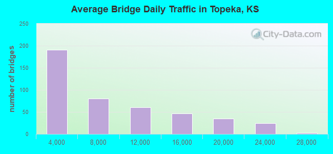
- 3,170,851Total average daily traffic
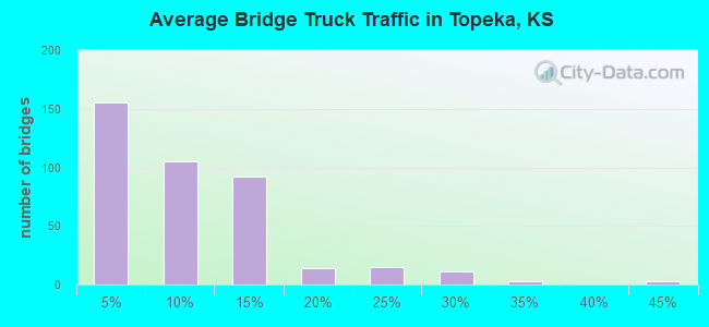
- 301,084Total average daily truck traffic
- National Bridge Inventory (NBI) Registered Bridges for Topeka
- No street view available for this location
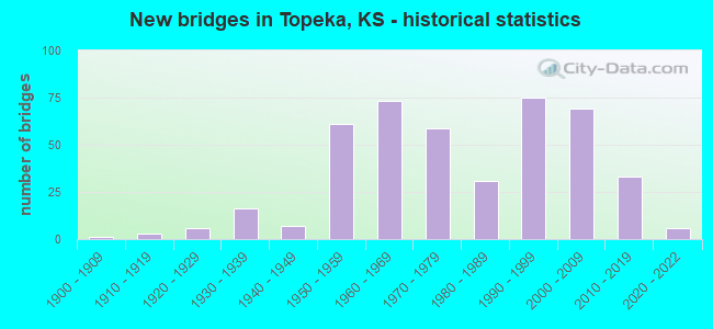
- New bridges - historical statistics
- 11900-1909
- 31910-1919
- 61920-1929
- 161930-1939
- 71940-1949
- 611950-1959
- 731960-1969
- 591970-1979
- 311980-1989
- 751990-1999
- 692000-2009
- 332010-2019
- 62020-2022
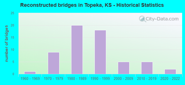
- Reconstructed bridges - Historical Statistics
- 11960-1969
- 91970-1979
- 201980-1989
- 181990-1999
- 52000-2009
- 52010-2019
- 22020-2022
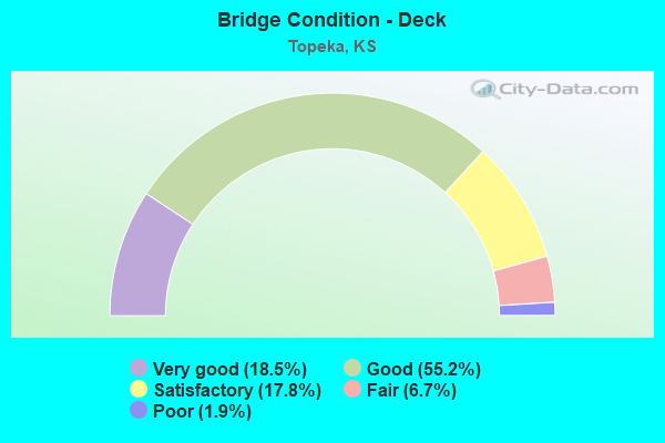
- Bridge Condition - Deck
- 18.5%Very good
- 55.2%Good
- 17.8%Satisfactory
- 6.7%Fair
- 1.9%Poor
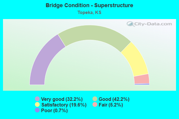
- Bridge Condition - Superstructure
- 32.2%Very good
- 42.2%Good
- 19.6%Satisfactory
- 5.2%Fair
- 0.7%Poor
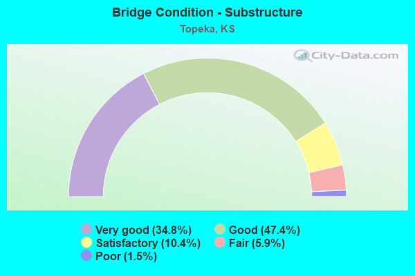
- Bridge Condition - Substructure
- 34.8%Very good
- 47.4%Good
- 10.4%Satisfactory
- 5.9%Fair
- 1.5%Poor
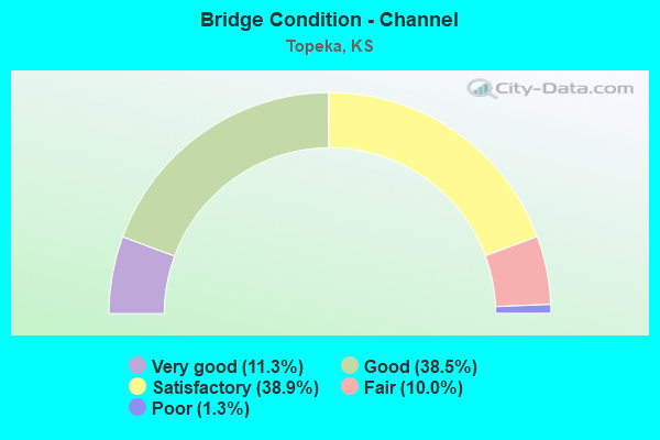
- Bridge Condition - Channel
- 11.3%Very good
- 38.5%Good
- 38.9%Satisfactory
- 10.0%Fair
- 1.3%Poor
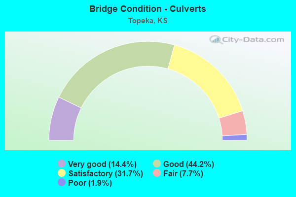
- Bridge Condition - Culverts
- 14.4%Very good
- 44.2%Good
- 31.7%Satisfactory
- 7.7%Fair
- 1.9%Poor
Find on map >> Show street view
Structure Number: 999907000890191, Location: 0.47 MI E FAIRLAWN AVE (Lat: 39.064444, Lng: -95.736389), Route carried "on" structure: Interstate 70, Year Built: 1956, Year Reconstructed: 1977, Status: Open, Structure Length: 0.85m (2.79ft), Average Daily Traffic: 29,645 (year 2020), Truck Traffic: 11%, Average Future Daily Traffic: 45,811 (year 2041), Design Load: H 20, Features Intersected: DANBURY LANE
Minimum Vertical Clearance: 30.47m (99.97ft), Kilometerpoint: 18.778, Lanes on structure: 6, Lanes under structure: 2, Base Highway Network: Yes, Owner: State Highway Agency, Approaching Roadway Width: 27.4m (89.9ft), Skew: 30 degrees, Material/Design: Concrete, Design/Construction: Culvert, Number Of Spans In Main Unit: 1, Length of Maximum Span: 8.5m (27.9ft), Curb-To-Curb Width: 33.1m (108.6ft), Out-to-Out Width: 33.5m (109.9ft)
Condition: Culverts: Satisfactory, Operating Rating: 41.2 metric tons, Method Used To Determine Operating Rating: Load Factor (LF), Inventory Rating: 24.7 metric tons, Method Used To Determine Inventory Rating: Load Factor (LF), Structural Evaluation: Equal to present minimum criteria, Deck Geometry: Superior to present desirable criteria, Underclear: High priority of corrective action, Approach Roadway Alignment: Equal to present desirable criteria, Length Of Structure Improvement: 2.80m (9.19ft), Designated Inspection Frequency: Every 24 months, Inspection Date: April 2020, Deck Structure Type: Concrete Cast-file-Place, Wearing Surface/Protective System: Wearing Surface: Monolithic Concrete
Find on map >> Show street view
Structure Number: 999907000890241, Location: 1.28 MI E GAGE BLVD (Lat: 39.069167, Lng: -95.701667), Route carried "on" structure: Interstate 70, Year Built: 1961, Status: Open, Structure Length: 1.95m (6.40ft), Average Daily Traffic: 21,552 (year 2020), Truck Traffic: 12%, Average Future Daily Traffic: 32,025 (year 2041), Design Load: HS 20+Mod, Features Intersected: WARD CREEK
Minimum Vertical Clearance: 30.47m (99.97ft), Kilometerpoint: 21.937, Lanes on structure: 5, Base Highway Network: Yes, Owner: State Highway Agency, Approaching Roadway Width: 24.4m (80.1ft), Skew: 22 degrees, Material/Design: Concrete, Design/Construction: Culvert, Number Of Spans In Main Unit: 4, Length of Maximum Span: 4.4m (14.4ft), Curb-To-Curb Width: 34.2m (112.2ft), Out-to-Out Width: 87.3m (286.4ft)
Condition: Channel: Good, Culverts: Good, Operating Rating: 89.8 metric tons, Method Used To Determine Operating Rating: Load Factor (LF), Inventory Rating: 89.8 metric tons, Method Used To Determine Inventory Rating: Load Factor (LF), Structural Evaluation: Better than present minimum criteria, Deck Geometry: Superior to present desirable criteria, Waterway Adequacy: Equal to present desirable criteria, Approach Roadway Alignment: Equal to present desirable criteria, Length Of Structure Improvement: 6.40m (21.00ft), Designated Inspection Frequency: Every 24 months, Inspection Date: April 2020, Deck Structure Type: Concrete Cast-file-Place, Wearing Surface/Protective System: Wearing Surface: Monolithic Concrete
Find on map >> Show street view
Structure Number: 999907000890251, Location: 2.14 MI E GAGE BLVD (Lat: 39.065000, Lng: -95.686667), Route carried "on" structure: Interstate 70, Year Built: 1960, Status: Open, Structure Length: 0.85m (2.79ft), Average Daily Traffic: 21,552 (year 2020), Truck Traffic: 12%, Average Future Daily Traffic: 32,025 (year 2041), Design Load: HS 20+Mod, Features Intersected: QUINTON STREET
Minimum Vertical Clearance: 30.47m (99.97ft), Kilometerpoint: 23.316, Lanes on structure: 4, Lanes under structure: 2, Base Highway Network: Yes, Owner: State Highway Agency, Approaching Roadway Width: 24.4m (80.1ft), Skew: 20 degrees, Material/Design: Concrete, Design/Construction: Culvert, Number Of Spans In Main Unit: 1, Length of Maximum Span: 8.5m (27.9ft), Curb-To-Curb Width: 33.0m (108.3ft), Out-to-Out Width: 37.4m (122.7ft)
Condition: Culverts: Satisfactory, Operating Rating: 33.9 metric tons, Method Used To Determine Operating Rating: Load Factor (LF), Inventory Rating: 20.3 metric tons, Method Used To Determine Inventory Rating: Load Factor (LF), Structural Evaluation: Somewhat better than minimum adequacy, Deck Geometry: Superior to present desirable criteria, Underclear: High priority of corrective action, Approach Roadway Alignment: Equal to present desirable criteria, Length Of Structure Improvement: 2.80m (9.19ft), Designated Inspection Frequency: Every 24 months, Inspection Date: April 2020, Deck Structure Type: Concrete Cast-file-Place, Wearing Surface/Protective System: Wearing Surface: Monolithic Concrete
Find on map >> Show street view
Structure Number: 999907000890261, Location: 0.14 MI E TOPEKA AVE (Lat: 39.058056, Lng: -95.674167), Route carried "on" structure: Interstate 70, Year Built: 1963, Status: Posted for load-capacity, Structure Length: 102.82m (337.34ft), Average Daily Traffic: 17,722 (year 2020), Truck Traffic: 14%, Average Future Daily Traffic: 26,334 (year 2041), Design Load: HS 20+Mod, Features Intersected: 8 STREETS, 3 RR
Minimum Vertical Clearance: 30.47m (99.97ft), Kilometerpoint: 24.686, Lanes on structure: 4, Lanes under structure: 24, Base Highway Network: Yes, Owner: State Highway Agency, Approaching Roadway Width: 18.3m (60.0ft), Skew: 30 degrees, Material/Design: Steel continuous, Design/Construction: Stringer/Multi-beam, Number Of Spans In Main Unit: 10, Number Of Approach Spans: 34, Length of Maximum Span: 36.6m (120.1ft), Curb-To-Curb Width: 18.3m (60.0ft), Out-to-Out Width: 19.8m (65.0ft)
Condition: Deck: Poor, Superstructure: Good, Substructure: Satisfactory, Operating Rating: 54.6 metric tons, Method Used To Determine Operating Rating: Load Factor (LF), Inventory Rating: 32.7 metric tons, Method Used To Determine Inventory Rating: Load Factor (LF), Structural Evaluation: Equal to present minimum criteria, Deck Geometry: Meets minimum limits, Underclear: High priority of corrective action, Approach Roadway Alignment: Meets minimum limits, Length Of Structure Improvement: 337.31m (1106.66ft), Designated Inspection Frequency: Every 24 months, Inspection Date: April 2020, Deck Structure Type: Concrete Cast-file-Place, Wearing Surface/Protective System: Wearing Surface: Epoxy Overlay, Membrane: Preformed Fabric
Find on map >> Show street view
Structure Number: 999907000890271, Location: 0.56 MI E TOPEKA AVE (Lat: 39.055000, Lng: -95.668056), Route carried "on" structure: Interstate 70, Year Built: 1963, Year Reconstructed: 1989, Status: Open, Structure Length: 4.85m (15.91ft), Average Daily Traffic: 17,394 (year 2020), Truck Traffic: 14%, Average Future Daily Traffic: 25,847 (year 2041), Design Load: HS 20+Mod, Features Intersected: 3RD STREET
Minimum Vertical Clearance: 30.47m (99.97ft), Kilometerpoint: 25.373, Lanes on structure: 4, Lanes under structure: 4, Base Highway Network: Yes, Owner: State Highway Agency, Approaching Roadway Width: 24.4m (80.1ft), Skew: 32 degrees, Material/Design: Concrete continuous, Design/Construction: Slab, Number Of Spans In Main Unit: 3, Length of Maximum Span: 18.3m (60.0ft), Curb-To-Curb Width: 25.3m (83.0ft), Out-to-Out Width: 26.1m (85.6ft)
Condition: Deck: Good, Superstructure: Good, Substructure: Good, Operating Rating: 88.9 metric tons, Method Used To Determine Operating Rating: Load Factor (LF), Inventory Rating: 53.5 metric tons, Method Used To Determine Inventory Rating: Load Factor (LF), Structural Evaluation: Better than present minimum criteria, Deck Geometry: Superior to present desirable criteria, Underclear: Meets minimum limits, Approach Roadway Alignment: Somewhat better than minimum adequacy, Length Of Structure Improvement: 15.93m (52.26ft), Designated Inspection Frequency: Every 24 months, Inspection Date: April 2020, Deck Structure Type: Concrete Cast-file-Place, Wearing Surface/Protective System: Wearing Surface: Epoxy Overlay
Find on map >> Show street view
Structure Number: 999907000890281, Location: 0.67 MI E TOPEKA AVE (Lat: 39.053333, Lng: -95.668333), Route carried "on" structure: Interstate 70, Year Built: 1964, Year Reconstructed: 1989, Status: Open, Structure Length: 6.00m (19.69ft), Average Daily Traffic: 17,394 (year 2020), Truck Traffic: 14%, Average Future Daily Traffic: 26,879 (year 2041), Design Load: HS 20+Mod, Features Intersected: 4TH STREET
Minimum Vertical Clearance: 30.47m (99.97ft), Kilometerpoint: 25.540, Lanes on structure: 4, Lanes under structure: 6, Base Highway Network: Yes, Owner: State Highway Agency, Approaching Roadway Width: 24.4m (80.1ft), Skew: 30 degrees, Material/Design: Concrete continuous, Design/Construction: Slab, Number Of Spans In Main Unit: 4, Length of Maximum Span: 15.8m (51.8ft), Curb-To-Curb Width: 25.3m (83.0ft), Out-to-Out Width: 26.1m (85.6ft)
Condition: Deck: Good, Superstructure: Satisfactory, Substructure: Good, Operating Rating: 78.0 metric tons, Method Used To Determine Operating Rating: Load Factor (LF), Inventory Rating: 47.2 metric tons, Method Used To Determine Inventory Rating: Load Factor (LF), Structural Evaluation: Equal to present minimum criteria, Deck Geometry: Superior to present desirable criteria, Underclear: Meets minimum limits, Approach Roadway Alignment: Somewhat better than minimum adequacy, Length Of Structure Improvement: 19.70m (64.63ft), Designated Inspection Frequency: Every 24 months, Inspection Date: April 2020, Deck Structure Type: Concrete Cast-file-Place, Wearing Surface/Protective System: Wearing Surface: Epoxy Overlay
Find on map >> Show street view
Structure Number: 999907000890291, Location: 0.87 MI E TOPEKA AVE (Lat: 39.050556, Lng: -95.669444), Route carried "on" structure: City street 5290, Year Built: 1963, Status: Open, Structure Length: 6.19m (20.31ft), Average Daily Traffic: 6,789 (year 2020), Truck Traffic: 5%, Average Future Daily Traffic: 6,926 (year 2041), Design Load: HS 20, Features Intersected: I70 HWY, NL-SL
Minimum Vertical Clearance: 30.47m (99.97ft), Kilometerpoint: 8.204, Lanes on structure: 5, Lanes under structure: 5, Owner: State Highway Agency, Approaching Roadway Width: 23.2m (76.1ft), Material/Design: Concrete continuous, Design/Construction: Slab, Number Of Spans In Main Unit: 4, Length of Maximum Span: 17.1m (56.1ft), Curb or Sidewalk Widths: Left: 1.9m (6.2ft), Right: 1.9m (6.2ft), Curb-To-Curb Width: 23.2m (76.1ft), Out-to-Out Width: 27.4m (89.9ft)
Condition: Deck: Satisfactory, Superstructure: Satisfactory, Substructure: Good, Operating Rating: 78.0 metric tons, Method Used To Determine Operating Rating: Load Factor (LF), Inventory Rating: 46.3 metric tons, Method Used To Determine Inventory Rating: Load Factor (LF), Structural Evaluation: Equal to present minimum criteria, Deck Geometry: Better than present minimum criteria, Underclear: Meets minimum limits, Approach Roadway Alignment: Somewhat better than minimum adequacy, Length Of Structure Improvement: 20.30m (66.60ft), Designated Inspection Frequency: Every 24 months, Inspection Date: April 2020, Deck Structure Type: Concrete Cast-file-Place, Wearing Surface/Protective System: Wearing Surface: Epoxy Overlay
Find on map >> Show street view
Structure Number: 999907000890301, Location: 1.08 MI E TOPEKA AVE (Lat: 39.047778, Lng: -95.670556), Route carried "on" structure: City street 5214, Year Built: 1964, Status: Open, Structure Length: 6.19m (20.31ft), Average Daily Traffic: 4,339 (year 2020), Truck Traffic: 4%, Average Future Daily Traffic: 5,191 (year 2041), Design Load: HS 20, Features Intersected: I70 HWY, NL-SL, Facility Carried by Structure: 8TH ST.
Minimum Vertical Clearance: 30.47m (99.97ft), Kilometerpoint: 4.880, Lanes on structure: 7, Lanes under structure: 6, Owner: State Highway Agency, Approaching Roadway Width: 23.2m (76.1ft), Material/Design: Concrete continuous, Design/Construction: Slab, Number Of Spans In Main Unit: 4, Length of Maximum Span: 17.1m (56.1ft), Curb or Sidewalk Widths: Left: 1.9m (6.2ft), Right: 1.9m (6.2ft), Curb-To-Curb Width: 23.2m (76.1ft), Out-to-Out Width: 27.5m (90.2ft)
Condition: Deck: Good, Superstructure: Satisfactory, Substructure: Good, Operating Rating: 77.8 metric tons, Method Used To Determine Operating Rating: Load Factor (LF), Inventory Rating: 46.6 metric tons, Method Used To Determine Inventory Rating: Load Factor (LF), Structural Evaluation: Equal to present minimum criteria, Deck Geometry: High priority of replacement, Underclear: Meets minimum limits, Approach Roadway Alignment: Better than present minimum criteria, Length Of Structure Improvement: 20.30m (66.60ft), Designated Inspection Frequency: Every 24 months, Inspection Date: April 2020, Deck Structure Type: Concrete Cast-file-Place, Wearing Surface/Protective System: Wearing Surface: Low Slump Concrete
Find on map >> Show street view
Structure Number: 999907000890311, Location: JCT 10TH ST/I70 (Lat: 39.044722, Lng: -95.671667), Route carried "on" structure: City street 5330, Year Built: 1964, Status: Open, Structure Length: 6.71m (22.01ft), Average Daily Traffic: 8,042 (year 2020), Truck Traffic: 7%, Average Future Daily Traffic: 9,813 (year 2041), Design Load: HS 20, Features Intersected: I70 HWY, NL-SL
Minimum Vertical Clearance: 30.47m (99.97ft), Kilometerpoint: 12.925, Lanes on structure: 7, Lanes under structure: 7, Owner: State Highway Agency, Approaching Roadway Width: 23.2m (76.1ft), Skew: 1 degrees, Material/Design: Concrete continuous, Design/Construction: Slab, Number Of Spans In Main Unit: 4, Length of Maximum Span: 21.0m (68.9ft), Curb or Sidewalk Widths: Left: 1.9m (6.2ft), Right: 1.9m (6.2ft), Curb-To-Curb Width: 23.2m (76.1ft), Out-to-Out Width: 27.4m (89.9ft)
Condition: Deck: Good, Superstructure: Satisfactory, Substructure: Good, Operating Rating: 85.3 metric tons, Method Used To Determine Operating Rating: Load Factor (LF), Inventory Rating: 51.7 metric tons, Method Used To Determine Inventory Rating: Load Factor (LF), Structural Evaluation: Equal to present minimum criteria, Deck Geometry: High priority of replacement, Underclear: Meets minimum limits, Approach Roadway Alignment: Somewhat better than minimum adequacy, Length Of Structure Improvement: 22.00m (72.18ft), Designated Inspection Frequency: Every 24 months, Inspection Date: April 2020, Deck Structure Type: Concrete Cast-file-Place, Wearing Surface/Protective System: Wearing Surface: Low Slump Concrete
Find on map >> Show street view
Structure Number: 999907000890321, Location: 0.17 MI SE 10TH ST, WB (Lat: 39.042222, Lng: -95.670833), Route carried "on" structure: Interstate 70, Year Built: 1964, Year Reconstructed: 1989, Status: Open, Structure Length: 10.68m (35.04ft), Average Daily Traffic: 20,761 (year 2020), Truck Traffic: 11%, Average Future Daily Traffic: 32,082 (year 2041), Design Load: HS 20+Mod, Features Intersected: BNSF RR
Minimum Vertical Clearance: 30.47m (99.97ft), Kilometerpoint: 26.825, Lanes on structure: 4, Base Highway Network: Yes, Owner: State Highway Agency, Approaching Roadway Width: 18.0m (59.1ft), Skew: 2 degrees, Material/Design: Concrete continuous, Design/Construction: Slab, Number Of Spans In Main Unit: 7, Length of Maximum Span: 18.3m (60.0ft), Curb-To-Curb Width: 17.9m (58.7ft), Out-to-Out Width: 18.7m (61.4ft)
Condition: Deck: Good, Superstructure: Satisfactory, Substructure: Good, Operating Rating: 75.3 metric tons, Method Used To Determine Operating Rating: Load Factor (LF), Inventory Rating: 45.4 metric tons, Method Used To Determine Inventory Rating: Load Factor (LF), Structural Evaluation: Equal to present minimum criteria, Deck Geometry: Meets minimum limits, Underclear: Superior to present desirable criteria, Approach Roadway Alignment: Better than present minimum criteria, Length Of Structure Improvement: 35.03m (114.93ft), Designated Inspection Frequency: Every 24 months, Inspection Date: April 2020, Deck Structure Type: Concrete Cast-file-Place, Wearing Surface/Protective System: Wearing Surface: Epoxy Overlay
Find on map >> Show street view
Structure Number: 999907000890331, Location: 0.18 MI SE 10TH ST, EB (Lat: 39.042222, Lng: -95.671111), Route carried "on" structure: Interstate 70, Year Built: 1964, Year Reconstructed: 1989, Status: Open, Structure Length: 10.86m (35.63ft), Average Daily Traffic: 20,761 (year 2020), Truck Traffic: 11%, Average Future Daily Traffic: 32,082 (year 2041), Design Load: HS 20+Mod, Features Intersected: BNSF RR
Minimum Vertical Clearance: 30.47m (99.97ft), Kilometerpoint: 26.821, Lanes on structure: 4, Base Highway Network: Yes, Owner: State Highway Agency, Approaching Roadway Width: 19.2m (63.0ft), Skew: 2 degrees, Material/Design: Concrete continuous, Design/Construction: Slab, Number Of Spans In Main Unit: 7, Length of Maximum Span: 18.3m (60.0ft), Curb-To-Curb Width: 17.8m (58.4ft), Out-to-Out Width: 18.7m (61.4ft)
Condition: Deck: Good, Superstructure: Good, Substructure: Good, Operating Rating: 75.3 metric tons, Method Used To Determine Operating Rating: Load Factor (LF), Inventory Rating: 45.4 metric tons, Method Used To Determine Inventory Rating: Load Factor (LF), Structural Evaluation: Better than present minimum criteria, Deck Geometry: Meets minimum limits, Underclear: Superior to present desirable criteria, Approach Roadway Alignment: Better than present minimum criteria, Length Of Structure Improvement: 35.63m (116.90ft), Designated Inspection Frequency: Every 24 months, Inspection Date: April 2020, Deck Structure Type: Concrete Cast-file-Place, Wearing Surface/Protective System: Wearing Surface: Epoxy Overlay
Find on map >> Show street view
Structure Number: 999907000890341, Location: 0.41 MI SE 10TH ST, WB (Lat: 39.039722, Lng: -95.668611), Route carried "on" structure: Interstate 70, Year Built: 1965, Year Reconstructed: 1989, Status: Open, Structure Length: 18.60m (61.02ft), Average Daily Traffic: 20,761 (year 2020), Truck Traffic: 11%, Average Future Daily Traffic: 32,082 (year 2041), Design Load: HS 20+Mod, Features Intersected: RR,ADAMS ST,SHUNG CR
Minimum Vertical Clearance: 30.47m (99.97ft), Kilometerpoint: 27.174, Lanes on structure: 3, Lanes under structure: 2, Base Highway Network: Yes, Owner: State Highway Agency, Approaching Roadway Width: 15.5m (50.9ft), Skew: 2 degrees, Material/Design: Concrete continuous, Design/Construction: Box Beam or Girders - Multiple, Number Of Spans In Main Unit: 8, Number Of Approach Spans: 3, Length of Maximum Span: 19.5m (64.0ft), Curb-To-Curb Width: 15.5m (50.9ft), Out-to-Out Width: 16.4m (53.8ft)
Condition: Deck: Good, Superstructure: Good, Substructure: Good, Channel: Good, Operating Rating: 61.3 metric tons, Method Used To Determine Operating Rating: Load Factor (LF), Inventory Rating: 36.7 metric tons, Method Used To Determine Inventory Rating: Load Factor (LF), Structural Evaluation: Better than present minimum criteria, Deck Geometry: Somewhat better than minimum adequacy, Underclear: Meets minimum limits, Waterway Adequacy: Better than present minimum criteria, Approach Roadway Alignment: Equal to present desirable criteria, Length Of Structure Improvement: 61.03m (200.23ft), Designated Inspection Frequency: Every 24 months, Inspection Date: April 2020, Deck Structure Type: Concrete Cast-file-Place, Wearing Surface/Protective System: Wearing Surface: Epoxy Overlay
Find on map >> Show street view
Structure Number: 999907000890351, Location: 0.42 MI SE 10TH ST, EB (Lat: 39.039722, Lng: -95.668333), Route carried "on" structure: Interstate 70, Year Built: 1965, Year Reconstructed: 1989, Status: Open, Structure Length: 18.60m (61.02ft), Average Daily Traffic: 20,761 (year 2020), Truck Traffic: 11%, Average Future Daily Traffic: 32,082 (year 2041), Design Load: HS 20+Mod, Features Intersected: RR,ADAMS ST,SHUNG CR
Minimum Vertical Clearance: 30.47m (99.97ft), Kilometerpoint: 27.175, Lanes on structure: 3, Lanes under structure: 2, Base Highway Network: Yes, Owner: State Highway Agency, Approaching Roadway Width: 15.8m (51.8ft), Skew: 2 degrees, Material/Design: Concrete continuous, Design/Construction: Box Beam or Girders - Multiple, Number Of Spans In Main Unit: 8, Number Of Approach Spans: 3, Length of Maximum Span: 19.5m (64.0ft), Curb-To-Curb Width: 15.6m (51.2ft), Out-to-Out Width: 16.4m (53.8ft)
Condition: Deck: Good, Superstructure: Good, Substructure: Satisfactory, Channel: Satisfactory, Operating Rating: 61.0 metric tons, Method Used To Determine Operating Rating: Load Factor (LF), Inventory Rating: 36.6 metric tons, Method Used To Determine Inventory Rating: Load Factor (LF), Structural Evaluation: Equal to present minimum criteria, Deck Geometry: Somewhat better than minimum adequacy, Underclear: Meets minimum limits, Waterway Adequacy: Equal to present minimum criteria, Approach Roadway Alignment: Better than present minimum criteria, Length Of Structure Improvement: 61.03m (200.23ft), Designated Inspection Frequency: Every 24 months, Inspection Date: April 2020, Deck Structure Type: Concrete Cast-file-Place, Wearing Surface/Protective System: Wearing Surface: Epoxy Overlay
Find on map >> Show street view
Structure Number: 999907000890361, Location: 0.67 MI SE 10TH ST, NL (Lat: 39.038056, Lng: -95.664444), Route carried "on" structure: Interstate 70, Year Built: 1964, Year Reconstructed: 1989, Status: Open, Structure Length: 3.73m (12.24ft), Average Daily Traffic: 19,405 (year 2020), Truck Traffic: 12%, Average Future Daily Traffic: 29,987 (year 2041), Design Load: HS 20+Mod, Features Intersected: WASHINGTON ST
Minimum Vertical Clearance: 30.47m (99.97ft), Kilometerpoint: 27.602, Lanes on structure: 7, Lanes under structure: 2, Base Highway Network: Yes, Owner: State Highway Agency, Approaching Roadway Width: 33.1m (108.6ft), Skew: 33 degrees, Material/Design: Concrete continuous, Design/Construction: Slab, Number Of Spans In Main Unit: 3, Length of Maximum Span: 13.1m (43.0ft), Curb-To-Curb Width: 34.9m (114.5ft), Out-to-Out Width: 35.7m (117.1ft)
Condition: Deck: Good, Superstructure: Good, Substructure: Good, Operating Rating: 67.1 metric tons, Method Used To Determine Operating Rating: Load Factor (LF), Inventory Rating: 39.9 metric tons, Method Used To Determine Inventory Rating: Load Factor (LF), Structural Evaluation: Better than present minimum criteria, Deck Geometry: Superior to present desirable criteria, Underclear: High priority of corrective action, Approach Roadway Alignment: Equal to present desirable criteria, Length Of Structure Improvement: 12.25m (40.19ft), Designated Inspection Frequency: Every 24 months, Inspection Date: April 2020, Deck Structure Type: Concrete Cast-file-Place, Wearing Surface/Protective System: Wearing Surface: Epoxy Overlay
Find on map >> Show street view
Structure Number: 999907000890381, Location: 0.89 MI SE 10TH ST (Lat: 39.036944, Lng: -95.660278), Route carried "on" structure: City street 5541, Year Built: 1964, Status: Open, Structure Length: 6.58m (21.59ft), Average Daily Traffic: 1,734 (year 2020), Truck Traffic: 4%, Average Future Daily Traffic: 2,116 (year 2041), Design Load: HS 20, Features Intersected: I70 HWY, NL-SL, Facility Carried by Structure: INDIANA ST.
Minimum Vertical Clearance: 30.47m (99.97ft), Kilometerpoint: 4.049, Lanes on structure: 2, Lanes under structure: 5, Owner: State Highway Agency, Approaching Roadway Width: 9.5m (31.2ft), Skew: 1 degrees, Material/Design: Concrete continuous, Design/Construction: Slab, Number Of Spans In Main Unit: 4, Length of Maximum Span: 18.3m (60.0ft), Curb or Sidewalk Widths: Left: 1.2m (3.9ft), Right: 1.2m (3.9ft), Curb-To-Curb Width: 9.5m (31.2ft), Out-to-Out Width: 12.5m (41.0ft)
Condition: Deck: Satisfactory, Superstructure: Good, Substructure: Good, Operating Rating: 74.4 metric tons, Method Used To Determine Operating Rating: Load Factor (LF), Inventory Rating: 44.5 metric tons, Method Used To Determine Inventory Rating: Load Factor (LF), Structural Evaluation: Better than present minimum criteria, Deck Geometry: Somewhat better than minimum adequacy, Underclear: Meets minimum limits, Approach Roadway Alignment: Meets minimum limits, Length Of Structure Improvement: 21.60m (70.87ft), Designated Inspection Frequency: Every 24 months, Inspection Date: April 2020, Deck Structure Type: Concrete Cast-file-Place, Wearing Surface/Protective System: Wearing Surface: Monolithic Concrete
Find on map >> Show street view
Structure Number: 999907000890391, Location: JCT CALIFORNIA AVE/I70 (Lat: 39.034722, Lng: -95.650833), Route carried "on" structure: City street 5561, Year Built: 1964, Status: Open, Structure Length: 6.52m (21.39ft), Average Daily Traffic: 11,209 (year 2020), Truck Traffic: 6%, Average Future Daily Traffic: 13,677 (year 2041), Design Load: HS 20, Features Intersected: I70 HWY, NL-SL
Minimum Vertical Clearance: 30.47m (99.97ft), Kilometerpoint: 5.411, Lanes on structure: 4, Lanes under structure: 4, Owner: State Highway Agency, Approaching Roadway Width: 21.4m (70.2ft), Skew: 21 degrees, Material/Design: Concrete continuous, Design/Construction: Slab, Number Of Spans In Main Unit: 4, Length of Maximum Span: 18.0m (59.1ft), Curb or Sidewalk Widths: Left: 1.2m (3.9ft), Right: 1.2m (3.9ft), Curb-To-Curb Width: 21.4m (70.2ft), Out-to-Out Width: 24.4m (80.1ft)
Condition: Deck: Poor, Superstructure: Good, Substructure: Good, Operating Rating: 75.3 metric tons, Method Used To Determine Operating Rating: Load Factor (LF), Inventory Rating: 45.4 metric tons, Method Used To Determine Inventory Rating: Load Factor (LF), Structural Evaluation: Better than present minimum criteria, Deck Geometry: Superior to present desirable criteria, Underclear: Meets minimum limits, Approach Roadway Alignment: Better than present minimum criteria, Length Of Structure Improvement: 21.40m (70.21ft), Designated Inspection Frequency: Every 24 months, Inspection Date: April 2020, Deck Structure Type: Concrete Cast-file-Place, Wearing Surface/Protective System: Wearing Surface: Monolithic Concrete
Find on map >> Show street view
Structure Number: 999907000890401, Location: 0.37 MI E CALIFORNIA AVE (Lat: 39.034167, Lng: -95.643889), Route carried "on" structure: City street 5291, Year Built: 1964, Status: Open, Structure Length: 6.31m (20.70ft), Average Daily Traffic: 3,272 (year 2020), Truck Traffic: 4%, Average Future Daily Traffic: 2,676 (year 2041), Design Load: HS 20, Features Intersected: I70 HWY, NL-SL, Facility Carried by Structure: GOLDEN ST.
Minimum Vertical Clearance: 30.47m (99.97ft), Kilometerpoint: 0.520, Lanes on structure: 2, Lanes under structure: 6, Owner: State Highway Agency, Approaching Roadway Width: 9.4m (30.8ft), Material/Design: Concrete continuous, Design/Construction: Slab, Number Of Spans In Main Unit: 4, Length of Maximum Span: 17.7m (58.1ft), Curb or Sidewalk Widths: Left: 1.2m (3.9ft), Right: 1.2m (3.9ft), Curb-To-Curb Width: 9.4m (30.8ft), Out-to-Out Width: 12.6m (41.3ft)
Condition: Deck: Satisfactory, Superstructure: Good, Substructure: Good, Operating Rating: 73.5 metric tons, Method Used To Determine Operating Rating: Load Factor (LF), Inventory Rating: 43.5 metric tons, Method Used To Determine Inventory Rating: Load Factor (LF), Structural Evaluation: Better than present minimum criteria, Deck Geometry: Meets minimum limits, Underclear: Meets minimum limits, Approach Roadway Alignment: Meets minimum limits, Length Of Structure Improvement: 20.70m (67.91ft), Designated Inspection Frequency: Every 24 months, Inspection Date: April 2020, Deck Structure Type: Concrete Cast-file-Place, Wearing Surface/Protective System: Wearing Surface: Monolithic Concrete
Find on map >> Show street view
Structure Number: 999907000890411, Location: I-70/DEER CREEK PKWY (Lat: 39.034167, Lng: -95.637222), Route carried "on" structure: Interstate 70, Year Built: 1965, Year Reconstructed: 1989, Status: Open, Structure Length: 5.09m (16.70ft), Average Daily Traffic: 19,482 (year 2020), Truck Traffic: 12%, Average Future Daily Traffic: 30,106 (year 2041), Design Load: HS 20+Mod, Features Intersected: DEER CR PKWY/CAR AVE
Minimum Vertical Clearance: 30.47m (99.97ft), Kilometerpoint: 30.011, Lanes on structure: 4, Lanes under structure: 4, Base Highway Network: Yes, Owner: State Highway Agency, Approaching Roadway Width: 28.0m (91.9ft), Skew: 30 degrees, Material/Design: Concrete continuous, Design/Construction: Slab, Number Of Spans In Main Unit: 4, Length of Maximum Span: 14.0m (45.9ft), Curb-To-Curb Width: 27.7m (90.9ft), Out-to-Out Width: 29.3m (96.1ft)
Condition: Deck: Good, Superstructure: Good, Substructure: Good, Operating Rating: 56.2 metric tons, Method Used To Determine Operating Rating: Load Factor (LF), Inventory Rating: 33.6 metric tons, Method Used To Determine Inventory Rating: Load Factor (LF), Structural Evaluation: Better than present minimum criteria, Deck Geometry: Superior to present desirable criteria, Underclear: Somewhat better than minimum adequacy, Approach Roadway Alignment: Equal to present desirable criteria, Length Of Structure Improvement: 16.70m (54.79ft), Designated Inspection Frequency: Every 24 months, Inspection Date: April 2020, Deck Structure Type: Concrete Cast-file-Place, Wearing Surface/Protective System: Wearing Surface: Epoxy Overlay
Find on map >> Show street view
Structure Number: 999907000890431, Location: 0.13 MI E US40 (Lat: 39.034167, Lng: -95.634722), Route carried "on" structure: Interstate 70, Year Built: 1964, Status: Open, Structure Length: 1.34m (4.40ft), Average Daily Traffic: 19,482 (year 2020), Truck Traffic: 12%, Average Future Daily Traffic: 30,106 (year 2041), Design Load: HS 20+Mod, Features Intersected: DEER CREEK
Minimum Vertical Clearance: 30.47m (99.97ft), Kilometerpoint: 30.212, Lanes on structure: 4, Base Highway Network: Yes, Owner: State Highway Agency, Approaching Roadway Width: 24.4m (80.1ft), Skew: 30 degrees, Material/Design: Steel, Design/Construction: Culvert, Number Of Spans In Main Unit: 1, Length of Maximum Span: 13.4m (44.0ft), Curb-To-Curb Width: 24.4m (80.1ft), Out-to-Out Width: 61.0m (200.1ft)
Condition: Channel: Good, Culverts: Good, Operating Rating: 58.1 metric tons, Method Used To Determine Operating Rating: Load Factor (LF), Inventory Rating: 34.5 metric tons, Method Used To Determine Inventory Rating: Load Factor (LF), Structural Evaluation: Better than present minimum criteria, Deck Geometry: Superior to present desirable criteria, Waterway Adequacy: Equal to present minimum criteria, Approach Roadway Alignment: Equal to present desirable criteria, Length Of Structure Improvement: 4.40m (14.44ft), Designated Inspection Frequency: Every 24 months, Inspection Date: April 2020, Deck Structure Type: Concrete Cast-file-Place, Wearing Surface/Protective System: Wearing Surface: Monolithic Concrete
Find on map >> Show street view
Structure Number: 999907000891773, Location: 0.92 MI E TECUMSEH OVRP (Lat: 39.030000, Lng: -95.570278), Route carried "on" structure: Interstate 70, Year Built: 1955, Status: Open, Structure Length: 0.76m (2.49ft), Average Daily Traffic: 17,985 (year 2020), Truck Traffic: 18%, Average Future Daily Traffic: 29,471 (year 2041), Design Load: H 20, Features Intersected: TECUMSEH CREEK
Minimum Vertical Clearance: 30.47m (99.97ft), Kilometerpoint: 35.879, Lanes on structure: 6, Base Highway Network: Yes, Toll: On Interstate toll segment, Owner: State Toll Authority, Approaching Roadway Width: 27.4m (89.9ft), Skew: 20 degrees, Material/Design: Concrete, Design/Construction: Culvert, Number Of Spans In Main Unit: 2, Length of Maximum Span: 3.7m (12.1ft), Curb-To-Curb Width: 27.4m (89.9ft), Out-to-Out Width: 85.1m (279.2ft)
Condition: Channel: Satisfactory, Culverts: Good, Operating Rating: 88.2 metric tons, Method Used To Determine Operating Rating: Load Factor (LF), Inventory Rating: 52.3 metric tons, Method Used To Determine Inventory Rating: Load Factor (LF), Structural Evaluation: Better than present minimum criteria, Deck Geometry: Equal to present minimum criteria, Waterway Adequacy: Better than present minimum criteria, Approach Roadway Alignment: Equal to present desirable criteria, Length Of Structure Improvement: 2.49m (8.17ft), Designated Inspection Frequency: Every 24 months, Inspection Date: June 2020, Deck Structure Type: Concrete Cast-file-Place, Wearing Surface/Protective System: Wearing Surface: Bituminous
Find on map >> Show street view
Structure Number: 999907000891901, Location: JCT 6TH STREET/I-70 (Lat: 39.058056, Lng: -95.745833), Route carried "on" structure: City street 5290, Year Built: 1993, Status: Open, Structure Length: 12.08m (39.63ft), Average Daily Traffic: 2,467 (year 2020), Truck Traffic: 7%, Average Future Daily Traffic: 3,666 (year 2041), Design Load: HS 20+Mod, Features Intersected: I-70 HWY NL-SL, Facility Carried by Structure: 6TH STREET
Minimum Vertical Clearance: 30.47m (99.97ft), Kilometerpoint: 1.444, Lanes on structure: 2, Lanes under structure: 4, Owner: State Highway Agency, Approaching Roadway Width: 12.2m (40.0ft), Skew: 5 degrees, Material/Design: Steel continuous, Design/Construction: Stringer/Multi-beam, Number Of Spans In Main Unit: 4, Length of Maximum Span: 36.6m (120.1ft), Curb or Sidewalk Widths: Left: 0.0m, Right: 1.5m (4.9ft), Curb-To-Curb Width: 12.2m (40.0ft), Out-to-Out Width: 14.8m (48.6ft)
Condition: Deck: Good, Superstructure: Satisfactory, Substructure: Good, Operating Rating: 77.1 metric tons, Method Used To Determine Operating Rating: Load Factor (LF), Inventory Rating: 46.3 metric tons, Method Used To Determine Inventory Rating: Load Factor (LF), Structural Evaluation: Equal to present minimum criteria, Deck Geometry: Equal to present minimum criteria, Underclear: Equal to present minimum criteria, Approach Roadway Alignment: Meets minimum limits, Length Of Structure Improvement: 39.63m (130.02ft), Designated Inspection Frequency: Every 24 months, Inspection Date: April 2020, Wearing Surface/Protective System: Wearing Surface: Low Slump Concrete, Deck Protection: Epoxy Coated Reinforcing
Find on map >> Show street view
Structure Number: 999907000891911, Location: JCT I-70 / FAIRLAWN RD (Lat: 39.060000, Lng: -95.743056), Route carried "on" structure: City street 5301, Year Built: 1993, Status: Open, Structure Length: 9.27m (30.41ft), Average Daily Traffic: 8,525 (year 2020), Truck Traffic: 7%, Average Future Daily Traffic: 10,822 (year 2041), Design Load: HS 20+Mod, Features Intersected: I-70 HWY EB-WB, Facility Carried by Structure: FAIRLAWN
Minimum Vertical Clearance: 30.47m (99.97ft), Kilometerpoint: 6.700, Lanes on structure: 4, Lanes under structure: 4, Owner: State Highway Agency, Approaching Roadway Width: 17.1m (56.1ft), Skew: 4 degrees, Material/Design: Steel continuous, Design/Construction: Stringer/Multi-beam, Number Of Spans In Main Unit: 4, Length of Maximum Span: 26.2m (86.0ft), Curb or Sidewalk Widths: Left: 0.0m, Right: 1.5m (4.9ft), Curb-To-Curb Width: 17.1m (56.1ft), Out-to-Out Width: 19.7m (64.6ft)
Condition: Deck: Good, Superstructure: Good, Substructure: Good, Operating Rating: 45.7 metric tons, Method Used To Determine Operating Rating: Load Factor (LF), Inventory Rating: 27.4 metric tons, Method Used To Determine Inventory Rating: Load Factor (LF), Structural Evaluation: Equal to present minimum criteria, Deck Geometry: Somewhat better than minimum adequacy, Underclear: Equal to present minimum criteria, Approach Roadway Alignment: Meets minimum limits, Length Of Structure Improvement: 30.40m (99.74ft), Designated Inspection Frequency: Every 24 months, Inspection Date: April 2020, Wearing Surface/Protective System: Wearing Surface: Low Slump Concrete, Deck Protection: Epoxy Coated Reinforcing
Find on map >> Show street view
Structure Number: 999907000891921, Location: JCT GAGE BLVD/I70 EB (Lat: 39.067500, Lng: -95.724444), Route carried "on" structure: Interstate 70, Year Built: 1993, Status: Open, Structure Length: 4.95m (16.24ft), Average Daily Traffic: 23,941 (year 2020), Truck Traffic: 12%, Average Future Daily Traffic: 35,575 (year 2041), Design Load: HS 20+Mod, Features Intersected: GAGE BLVD
Minimum Vertical Clearance: 30.47m (99.97ft), Kilometerpoint: 19.887, Lanes on structure: 3, Lanes under structure: 3, Base Highway Network: Yes, Owner: State Highway Agency, Approaching Roadway Width: 15.2m (49.9ft), Material/Design: Concrete continuous, Design/Construction: Slab, Number Of Spans In Main Unit: 3, Length of Maximum Span: 19.5m (64.0ft), Curb-To-Curb Width: 15.5m (50.9ft), Out-to-Out Width: 16.1m (52.8ft)
Condition: Deck: Good, Superstructure: Good, Substructure: Very good, Operating Rating: 87.1 metric tons, Method Used To Determine Operating Rating: Load Factor (LF), Inventory Rating: 51.7 metric tons, Method Used To Determine Inventory Rating: Load Factor (LF), Structural Evaluation: Better than present minimum criteria, Deck Geometry: Somewhat better than minimum adequacy, Underclear: Equal to present desirable criteria, Approach Roadway Alignment: Better than present minimum criteria, Length Of Structure Improvement: 16.25m (53.31ft), Designated Inspection Frequency: Every 24 months, Inspection Date: April 2020, Wearing Surface/Protective System: Wearing Surface: Monolithic Concrete, Deck Protection: Epoxy Coated Reinforcing
Find on map >> Show street view
Structure Number: 999907000891931, Location: JCT GAGE BLVD/I70 WB (Lat: 39.067500, Lng: -95.724444), Route carried "on" structure: Interstate 70, Year Built: 1993, Status: Open, Structure Length: 4.95m (16.24ft), Average Daily Traffic: 23,941 (year 2020), Truck Traffic: 12%, Average Future Daily Traffic: 36,996 (year 2041), Design Load: HS 20+Mod, Features Intersected: GAGE BLVD
Minimum Vertical Clearance: 30.47m (99.97ft), Kilometerpoint: 19.887, Lanes on structure: 3, Lanes under structure: 3, Base Highway Network: Yes, Owner: State Highway Agency, Approaching Roadway Width: 15.2m (49.9ft), Material/Design: Concrete continuous, Design/Construction: Slab, Number Of Spans In Main Unit: 3, Length of Maximum Span: 19.5m (64.0ft), Curb-To-Curb Width: 15.5m (50.9ft), Out-to-Out Width: 16.3m (53.5ft)
Condition: Deck: Good, Superstructure: Good, Substructure: Good, Operating Rating: 87.1 metric tons, Method Used To Determine Operating Rating: Load Factor (LF), Inventory Rating: 51.7 metric tons, Method Used To Determine Inventory Rating: Load Factor (LF), Structural Evaluation: Better than present minimum criteria, Deck Geometry: Somewhat better than minimum adequacy, Underclear: Better than present minimum criteria, Approach Roadway Alignment: Better than present minimum criteria, Length Of Structure Improvement: 16.25m (53.31ft), Designated Inspection Frequency: Every 24 months, Inspection Date: April 2020, Wearing Surface/Protective System: Wearing Surface: Monolithic Concrete, Deck Protection: Epoxy Coated Reinforcing
Find on map >> Show street view
Structure Number: 999907000891941, Location: 1.02 MI E GAGE BLVD (Lat: 39.070278, Lng: -95.706111), Route carried "on" structure: Interstate 70, Year Built: 1993, Status: Open, Structure Length: 6.24m (20.47ft), Average Daily Traffic: 21,552 (year 2020), Truck Traffic: 12%, Average Future Daily Traffic: 32,025 (year 2041), Design Load: HS 20+Mod, Features Intersected: MACVICAR AVE
Minimum Vertical Clearance: 30.47m (99.97ft), Kilometerpoint: 21.539, Lanes on structure: 4, Lanes under structure: 4, Base Highway Network: Yes, Owner: State Highway Agency, Approaching Roadway Width: 25.3m (83.0ft), Skew: 32 degrees, Material/Design: Prestressed concrete continuous, Design/Construction: Stringer/Multi-beam, Number Of Spans In Main Unit: 3, Length of Maximum Span: 25.0m (82.0ft), Curb-To-Curb Width: 24.4m (80.1ft), Out-to-Out Width: 26.1m (85.6ft)
Condition: Deck: Good, Superstructure: Very good, Substructure: Good, Operating Rating: 89.8 metric tons, Method Used To Determine Operating Rating: Load Factor (LF), Inventory Rating: 49.4 metric tons, Method Used To Determine Inventory Rating: Load Factor (LF), Structural Evaluation: Better than present minimum criteria, Deck Geometry: Superior to present desirable criteria, Underclear: Better than present minimum criteria, Approach Roadway Alignment: Equal to present desirable criteria, Length Of Structure Improvement: 20.47m (67.16ft), Designated Inspection Frequency: Every 24 months, Inspection Date: April 2020, Wearing Surface/Protective System: Wearing Surface: Epoxy Overlay, Deck Protection: Epoxy Coated Reinforcing
Find on map >> Show street view
Structure Number: 999907000892021, Location: JCT WANAMAKER RD & I-70 (Lat: 39.053611, Lng: -95.761667), Route carried "on" structure: City street 5251, Year Built: 1993, Status: Open, Structure Length: 7.97m (26.15ft), Average Daily Traffic: 15,787 (year 2020), Truck Traffic: 6%, Average Future Daily Traffic: 16,106 (year 2041), Design Load: HS 20, Features Intersected: I-70 HWY EB - WB, Facility Carried by Structure: WANAMAKER
Minimum Vertical Clearance: 30.47m (99.97ft), Kilometerpoint: 10.874, Lanes on structure: 4, Lanes under structure: 4, Owner: State Highway Agency, Approaching Roadway Width: 19.5m (64.0ft), Material/Design: Steel continuous, Design/Construction: Stringer/Multi-beam, Number Of Spans In Main Unit: 4, Length of Maximum Span: 26.8m (87.9ft), Curb or Sidewalk Widths: Left: 0.0m, Right: 1.8m (5.9ft), Curb-To-Curb Width: 19.5m (64.0ft), Out-to-Out Width: 22.5m (73.8ft)
Condition: Deck: Good, Superstructure: Good, Substructure: Good, Operating Rating: 68.0 metric tons, Method Used To Determine Operating Rating: Load Factor (LF), Inventory Rating: 40.8 metric tons, Method Used To Determine Inventory Rating: Load Factor (LF), Structural Evaluation: Better than present minimum criteria, Deck Geometry: Better than present minimum criteria, Underclear: Somewhat better than minimum adequacy, Approach Roadway Alignment: Somewhat better than minimum adequacy, Length Of Structure Improvement: 26.15m (85.79ft), Designated Inspection Frequency: Every 24 months, Inspection Date: April 2020, Wearing Surface/Protective System: Wearing Surface: Low Slump Concrete, Deck Protection: Epoxy Coated Reinforcing
Find on map >> Show street view
Structure Number: 999907000892211, Location: JCT K-4/I-70, EB (Lat: 39.050278, Lng: -95.816944), Route carried "on" structure: Interstate 70, Year Built: 2002, Status: Open, Structure Length: 4.66m (15.29ft), Average Daily Traffic: 12,648 (year 2020), Truck Traffic: 16%, Average Future Daily Traffic: 18,071 (year 2041), Design Load: HS 25 or greater, Features Intersected: K-4, AUBURN RD
Minimum Vertical Clearance: 30.47m (99.97ft), Kilometerpoint: 11.376, Lanes on structure: 2, Lanes under structure: 3, Base Highway Network: Yes, Owner: State Highway Agency, Approaching Roadway Width: 12.2m (40.0ft), Material/Design: Steel continuous, Design/Construction: Stringer/Multi-beam, Number Of Spans In Main Unit: 3, Length of Maximum Span: 21.3m (69.9ft), Curb-To-Curb Width: 12.2m (40.0ft), Out-to-Out Width: 13.1m (43.0ft)
Condition: Deck: Good, Superstructure: Very good, Substructure: Very good, Operating Rating: 89.8 metric tons, Method Used To Determine Operating Rating: Load Factor (LF), Inventory Rating: 55.5 metric tons, Method Used To Determine Inventory Rating: Load Factor (LF), Structural Evaluation: Equal to present desirable criteria, Deck Geometry: Better than present minimum criteria, Underclear: Superior to present desirable criteria, Approach Roadway Alignment: Equal to present desirable criteria, Length Of Structure Improvement: 15.30m (50.20ft), Designated Inspection Frequency: Every 24 months, Inspection Date: April 2020, Wearing Surface/Protective System: Wearing Surface: Low Slump Concrete, Deck Protection: Epoxy Coated Reinforcing
Find on map >> Show street view
Structure Number: 999907000892221, Location: JCT K-4/I-70, WB (Lat: 39.050278, Lng: -95.816944), Route carried "on" structure: Interstate 70, Year Built: 1999, Status: Open, Structure Length: 4.68m (15.35ft), Average Daily Traffic: 14,829 (year 2020), Truck Traffic: 16%, Average Future Daily Traffic: 22,035 (year 2041), Design Load: HS 25 or greater, Features Intersected: K-4, AUBURN RD
Minimum Vertical Clearance: 30.47m (99.97ft), Kilometerpoint: 11.375, Lanes on structure: 3, Lanes under structure: 3, Base Highway Network: Yes, Owner: State Highway Agency, Approaching Roadway Width: 15.2m (49.9ft), Material/Design: Steel continuous, Design/Construction: Stringer/Multi-beam, Number Of Spans In Main Unit: 3, Length of Maximum Span: 21.4m (70.2ft), Curb-To-Curb Width: 15.2m (49.9ft), Out-to-Out Width: 15.8m (51.8ft)
Condition: Deck: Very good, Superstructure: Very good, Substructure: Very good, Operating Rating: 86.5 metric tons, Method Used To Determine Operating Rating: Load Factor (LF), Inventory Rating: 51.8 metric tons, Method Used To Determine Inventory Rating: Load Factor (LF), Structural Evaluation: Equal to present desirable criteria, Deck Geometry: Meets minimum limits, Underclear: Superior to present desirable criteria, Approach Roadway Alignment: Equal to present desirable criteria, Length Of Structure Improvement: 15.34m (50.33ft), Designated Inspection Frequency: Every 24 months, Inspection Date: April 2020, Wearing Surface/Protective System: Wearing Surface: Low Slump Concrete, Deck Protection: Epoxy Coated Reinforcing
Find on map >> Show street view
Structure Number: 999907000892491, Location: JCT RICE RD/I70 (Lat: 39.034167, Lng: -95.623056), Route carried "on" structure: City street 5293, Year Built: 2001, Status: Open, Structure Length: 8.55m (28.05ft), Average Daily Traffic: 1,941 (year 2020), Truck Traffic: 5%, Average Future Daily Traffic: 1,588 (year 2041), Design Load: HS 25 or greater, Features Intersected: I-70 HWY, Facility Carried by Structure: RICE ROAD
Minimum Vertical Clearance: 30.47m (99.97ft), Kilometerpoint: 0.525, Lanes on structure: 2, Lanes under structure: 6, Owner: State Highway Agency, Approaching Roadway Width: 11.0m (36.1ft), Material/Design: Prestressed concrete continuous, Design/Construction: Stringer/Multi-beam, Number Of Spans In Main Unit: 4, Length of Maximum Span: 25.0m (82.0ft), Curb or Sidewalk Widths: Left: 0.0m, Right: 1.5m (4.9ft), Curb-To-Curb Width: 12.2m (40.0ft), Out-to-Out Width: 14.8m (48.6ft)
Condition: Deck: Very good, Superstructure: Very good, Substructure: Good, Operating Rating: 89.8 metric tons, Method Used To Determine Operating Rating: Load Factor (LF), Inventory Rating: 48.4 metric tons, Method Used To Determine Inventory Rating: Load Factor (LF), Structural Evaluation: Better than present minimum criteria, Deck Geometry: Better than present minimum criteria, Underclear: Superior to present desirable criteria, Approach Roadway Alignment: Meets minimum limits, Length Of Structure Improvement: 28.05m (92.03ft), Designated Inspection Frequency: Every 24 months, Inspection Date: April 2020, Wearing Surface/Protective System: Wearing Surface: Low Slump Concrete, Deck Protection: Epoxy Coated Reinforcing
Find on map >> Show street view
Structure Number: 999907000892501, Location: JCT CROCO RD/I70 (Lat: 39.035000, Lng: -95.613611), Route carried "on" structure: County highway 5651, Year Built: 2001, Status: Open, Structure Length: 20.96m (68.77ft), Average Daily Traffic: 9,678 (year 2020), Truck Traffic: 5%, Average Future Daily Traffic: 10,693 (year 2041), Design Load: HS 25 or greater, Features Intersected: I-70 & RAMPS, Facility Carried by Structure: CROCO ROAD
Minimum Vertical Clearance: 30.47m (99.97ft), Kilometerpoint: 5.406, Lanes on structure: 3, Lanes under structure: 8, Owner: State Highway Agency, Approaching Roadway Width: 15.8m (51.8ft), Material/Design: Steel continuous, Design/Construction: Stringer/Multi-beam, Number Of Spans In Main Unit: 6, Length of Maximum Span: 44.5m (146.0ft), Curb-To-Curb Width: 15.8m (51.8ft), Out-to-Out Width: 16.6m (54.5ft)
Condition: Deck: Good, Superstructure: Very good, Substructure: Very good, Operating Rating: 70.8 metric tons, Method Used To Determine Operating Rating: Load Factor (LF), Inventory Rating: 42.6 metric tons, Method Used To Determine Inventory Rating: Load Factor (LF), Structural Evaluation: Equal to present desirable criteria, Deck Geometry: Better than present minimum criteria, Underclear: Superior to present desirable criteria, Approach Roadway Alignment: Meets minimum limits, Length Of Structure Improvement: 68.75m (225.56ft), Designated Inspection Frequency: Every 24 months, Inspection Date: April 2020, Wearing Surface/Protective System: Wearing Surface: Low Slump Concrete, Deck Protection: Epoxy Coated Reinforcing
Find on map >> Show street view
Structure Number: 999907000892541, Location: 0.29 MI E CROCO RD (Lat: 39.035000, Lng: -95.608333), Route carried "on" structure: Ramp US 40, Year Built: 2001, Status: Open, Structure Length: 18.33m (60.14ft), Average Daily Traffic: 2,500 (year 2020), Truck Traffic: 25%, Average Future Daily Traffic: 25,961 (year 2041), Design Load: HS 25 or greater, Features Intersected: I-70 HWY, Facility Carried by Structure: RAMP I70 TO K4
Minimum Vertical Clearance: 30.47m (99.97ft), Kilometerpoint: 32.538, Lanes on structure: 1, Lanes under structure: 5, Owner: State Highway Agency, Approaching Roadway Width: 8.5m (27.9ft), Material/Design: Steel continuous, Design/Construction: Stringer/Multi-beam, Number Of Spans In Main Unit: 4, Length of Maximum Span: 54.6m (179.1ft), Curb-To-Curb Width: 8.5m (27.9ft), Out-to-Out Width: 9.3m (30.5ft)
Condition: Deck: Good, Superstructure: Very good, Substructure: Very good, Operating Rating: 89.8 metric tons, Method Used To Determine Operating Rating: Load Factor (LF), Inventory Rating: 64.4 metric tons, Method Used To Determine Inventory Rating: Load Factor (LF), Structural Evaluation: Equal to present desirable criteria, Deck Geometry: Superior to present desirable criteria, Underclear: Equal to present minimum criteria, Approach Roadway Alignment: Somewhat better than minimum adequacy, Length Of Structure Improvement: 60.15m (197.34ft), Designated Inspection Frequency: Every 24 months, Inspection Date: April 2020, Wearing Surface/Protective System: Wearing Surface: Low Slump Concrete, Deck Protection: Epoxy Coated Reinforcing
Find on map >> Show street view
Structure Number: 999907000892561, Location: 0.04 M N JCT I70/U40 (Lat: 39.035278, Lng: -95.606389), Route carried "on" structure: Ramp State highway 30, Year Built: 2001, Status: Open, Structure Length: 30.51m (100.10ft), Average Daily Traffic: 1,655 (year 2020), Truck Traffic: 5%, Average Future Daily Traffic: 25,961 (year 2041), Design Load: HS 25 or greater, Features Intersected: EB K4/ I-70 RAMP, Facility Carried by Structure: RAMP K4W TO I-70E
Minimum Vertical Clearance: 30.47m (99.97ft), Kilometerpoint: 0.605, Lanes on structure: 1, Lanes under structure: 11, Owner: State Highway Agency, Approaching Roadway Width: 8.5m (27.9ft), Material/Design: Steel continuous, Design/Construction: Stringer/Multi-beam, Number Of Spans In Main Unit: 8, Length of Maximum Span: 50.0m (164.0ft), Curb-To-Curb Width: 8.5m (27.9ft), Out-to-Out Width: 9.3m (30.5ft)
Condition: Deck: Good, Superstructure: Very good, Substructure: Very good, Operating Rating: 70.8 metric tons, Method Used To Determine Operating Rating: Load Factor (LF), Inventory Rating: 41.7 metric tons, Method Used To Determine Inventory Rating: Load Factor (LF), Structural Evaluation: Equal to present desirable criteria, Deck Geometry: Superior to present desirable criteria, Underclear: Somewhat better than minimum adequacy, Approach Roadway Alignment: Somewhat better than minimum adequacy, Length Of Structure Improvement: 100.09m (328.38ft), Designated Inspection Frequency: Every 24 months, Inspection Date: April 2020, Wearing Surface/Protective System: Wearing Surface: Low Slump Concrete, Deck Protection: Epoxy Coated Reinforcing
Find on map >> Show street view
Structure Number: 999907000892573, Location: 4.95 MI W DOUGLAS COLN (Lat: 39.032500, Lng: -95.593056), Route carried "on" structure: Interstate 70, Year Built: 2002, Status: Open, Structure Length: 0.98m (3.22ft), Average Daily Traffic: 15,217 (year 2020), Truck Traffic: 13%, Average Future Daily Traffic: 23,515 (year 2041), Design Load: HS 20+Mod, Features Intersected: STINSON CREEK
Minimum Vertical Clearance: 30.47m (99.97ft), Kilometerpoint: 33.840, Lanes on structure: 9, Base Highway Network: Yes, Toll: On Interstate toll segment, Owner: State Toll Authority, Approaching Roadway Width: 131.0m (429.8ft), Skew: 23 degrees, Material/Design: Concrete, Design/Construction: Culvert, Number Of Spans In Main Unit: 3, Length of Maximum Span: 3.0m (9.8ft), Curb-To-Curb Width: 131.0m (429.8ft), Out-to-Out Width: 221.9m (728.0ft)
Condition: Channel: Good, Culverts: Good, Operating Rating: 43.2 metric tons, Method Used To Determine Operating Rating: Load Factor (LF), Inventory Rating: 32.4 metric tons, Method Used To Determine Inventory Rating: Load Factor (LF), Structural Evaluation: Better than present minimum criteria, Deck Geometry: Superior to present desirable criteria, Waterway Adequacy: Better than present minimum criteria, Approach Roadway Alignment: Equal to present desirable criteria, Length Of Structure Improvement: 3.20m (10.50ft), Designated Inspection Frequency: Every 24 months, Inspection Date: June 2020, Deck Structure Type: Concrete Cast-file-Place, Wearing Surface/Protective System: Wearing Surface: Monolithic Concrete
Find on map >> Show street view
Structure Number: 999907000892583, Location: JCT EB I70/WB I470 (Lat: 39.031389, Lng: -95.589444), Route carried "on" structure: Interstate 70, Year Built: 2002, Status: Open, Structure Length: 11.08m (36.35ft), Average Daily Traffic: 15,217 (year 2020), Truck Traffic: 13%, Average Future Daily Traffic: 23,515 (year 2041), Design Load: HS 25 or greater, Features Intersected: I-470 HWY, SB
Minimum Vertical Clearance: 30.47m (99.97ft), Kilometerpoint: 34.207, Lanes on structure: 2, Lanes under structure: 2, Base Highway Network: Yes, Toll: On Interstate toll segment, Owner: State Toll Authority, Approaching Roadway Width: 12.2m (40.0ft), Skew: 5 degrees, Material/Design: Steel continuous, Design/Construction: Stringer/Multi-beam, Number Of Spans In Main Unit: 3, Length of Maximum Span: 46.9m (153.9ft), Curb-To-Curb Width: 12.2m (40.0ft), Out-to-Out Width: 13.0m (42.7ft)
Condition: Deck: Good, Superstructure: Very good, Substructure: Very good, Operating Rating: 89.8 metric tons, Method Used To Determine Operating Rating: Load Factor (LF), Inventory Rating: 68.9 metric tons, Method Used To Determine Inventory Rating: Load Factor (LF), Structural Evaluation: Equal to present desirable criteria, Deck Geometry: Better than present minimum criteria, Underclear: Superior to present desirable criteria, Approach Roadway Alignment: Equal to present desirable criteria, Length Of Structure Improvement: 36.35m (119.26ft), Designated Inspection Frequency: Every 24 months, Inspection Date: June 2020, Wearing Surface/Protective System: Wearing Surface: Epoxy Overlay
Find on map >> Show street view
Structure Number: 999907000892593, Location: TECUMSEH RD/WB I70 & I470 (Lat: 39.031111, Lng: -95.585556), Route carried "on" structure: County highway 5221, Year Built: 2002, Status: Open, Structure Length: 8.78m (28.81ft), Average Daily Traffic: 610 (year 2020), Truck Traffic: 5%, Average Future Daily Traffic: 822 (year 2041), Design Load: HS 25 or greater, Features Intersected: NL I-70 AND NL I-470, Facility Carried by Structure: TECUMSEH ROAD
Minimum Vertical Clearance: 30.47m (99.97ft), Kilometerpoint: 6.701, Lanes on structure: 2, Lanes under structure: 4, Owner: State Toll Authority, Approaching Roadway Width: 9.8m (32.2ft), Material/Design: Steel continuous, Design/Construction: Stringer/Multi-beam, Number Of Spans In Main Unit: 3, Length of Maximum Span: 41.1m (134.8ft), Curb-To-Curb Width: 9.7m (31.8ft), Out-to-Out Width: 10.5m (34.4ft)
Condition: Deck: Very good, Superstructure: Very good, Substructure: Very good, Operating Rating: 89.8 metric tons, Method Used To Determine Operating Rating: Load Factor (LF), Inventory Rating: 60.7 metric tons, Method Used To Determine Inventory Rating: Load Factor (LF), Structural Evaluation: Equal to present desirable criteria, Deck Geometry: Equal to present minimum criteria, Underclear: Superior to present desirable criteria, Approach Roadway Alignment: Somewhat better than minimum adequacy, Length Of Structure Improvement: 28.80m (94.49ft), Designated Inspection Frequency: Every 24 months, Inspection Date: June 2020, Wearing Surface/Protective System: Wearing Surface: Epoxy Overlay
Find on map >> Show street view
Structure Number: 999907000892603, Location: TECUMSEH RD / EB 70&470 (Lat: 39.031111, Lng: -95.585556), Route carried "on" structure: County highway 5221, Year Built: 2002, Status: Open, Structure Length: 8.20m (26.90ft), Average Daily Traffic: 610 (year 2020), Truck Traffic: 5%, Average Future Daily Traffic: 822 (year 2041), Design Load: HS 25 or greater, Features Intersected: I-70 EB AND I-470 EB, Facility Carried by Structure: TECUMSEH ROAD
Minimum Vertical Clearance: 30.47m (99.97ft), Kilometerpoint: 6.581, Lanes on structure: 2, Lanes under structure: 6, Owner: State Toll Authority, Approaching Roadway Width: 9.8m (32.2ft), Material/Design: Steel continuous, Design/Construction: Stringer/Multi-beam, Number Of Spans In Main Unit: 3, Length of Maximum Span: 38.4m (126.0ft), Curb-To-Curb Width: 9.7m (31.8ft), Out-to-Out Width: 10.5m (34.4ft)
Condition: Deck: Very good, Superstructure: Very good, Substructure: Very good, Operating Rating: 89.8 metric tons, Method Used To Determine Operating Rating: Load Factor (LF), Inventory Rating: 56.2 metric tons, Method Used To Determine Inventory Rating: Load Factor (LF), Structural Evaluation: Equal to present desirable criteria, Deck Geometry: Equal to present minimum criteria, Underclear: Somewhat better than minimum adequacy, Approach Roadway Alignment: Somewhat better than minimum adequacy, Length Of Structure Improvement: 26.90m (88.25ft), Designated Inspection Frequency: Every 24 months, Inspection Date: June 2020, Wearing Surface/Protective System: Wearing Surface: Epoxy Overlay
Find on map >> Show street view
Structure Number: 999907500891011, Location: 0.50 MI N EJCT I70/US75 (Lat: 39.071111, Lng: -95.730833), Route carried "on" structure: US 75, Year Built: 1955, Year Reconstructed: 2001, Status: Open, Structure Length: 53.67m (176.08ft), Average Daily Traffic: 23,638 (year 2020), Truck Traffic: 9%, Average Future Daily Traffic: 33,115 (year 2041), Design Load: HS 25 or greater, Features Intersected: KANSAS RIVER, UP RR
Minimum Vertical Clearance: 30.47m (99.97ft), Kilometerpoint: 28.456, Lanes on structure: 2, Base Highway Network: Yes, Owner: State Highway Agency, Approaching Roadway Width: 12.2m (40.0ft), Material/Design: Steel continuous, Design/Construction: Stringer/Multi-beam, Number Of Spans In Main Unit: 12, Length of Maximum Span: 73.2m (240.2ft), Curb-To-Curb Width: 12.2m (40.0ft), Out-to-Out Width: 12.8m (42.0ft)
Condition: Deck: Very good, Superstructure: Very good, Substructure: Good, Channel: Good, Operating Rating: 55.9 metric tons, Method Used To Determine Operating Rating: Load Factor (LF), Inventory Rating: 33.5 metric tons, Method Used To Determine Inventory Rating: Load Factor (LF), Structural Evaluation: Better than present minimum criteria, Deck Geometry: Better than present minimum criteria, Underclear: Superior to present desirable criteria, Waterway Adequacy: Better than present minimum criteria, Approach Roadway Alignment: Better than present minimum criteria, Length Of Structure Improvement: 175.36m (575.33ft), Designated Inspection Frequency: Every 24 months, Inspection Date: May 2020, Wearing Surface/Protective System: Wearing Surface: Low Slump Concrete, Deck Protection: Epoxy Coated Reinforcing
Find on map >> Show street view
Structure Number: 999907500891541, Location: 0.50 MI N E-JCT US75-I70 (Lat: 39.071111, Lng: -95.731389), Route carried "on" structure: US 75, Year Built: 1977, Status: Posted for load-capacity, Structure Length: 53.77m (176.41ft), Average Daily Traffic: 23,638 (year 2020), Truck Traffic: 9%, Average Future Daily Traffic: 33,115 (year 2041), Design Load: HS 20, Features Intersected: KANSAS RIVER, UP RR
Minimum Vertical Clearance: 30.47m (99.97ft), Kilometerpoint: 28.481, Lanes on structure: 2, Base Highway Network: Yes, Owner: State Highway Agency, Approaching Roadway Width: 12.2m (40.0ft), Material/Design: Steel continuous, Design/Construction: Girder and Floorbeam System, Number Of Spans In Main Unit: 12, Length of Maximum Span: 73.2m (240.2ft), Curb-To-Curb Width: 12.2m (40.0ft), Out-to-Out Width: 12.6m (41.3ft)
Condition: Deck: Fair, Superstructure: Satisfactory, Substructure: Good, Channel: Satisfactory, Operating Rating: 45.4 metric tons, Method Used To Determine Operating Rating: Load Factor (LF), Inventory Rating: 27.2 metric tons, Method Used To Determine Inventory Rating: Load Factor (LF), Structural Evaluation: Equal to present minimum criteria, Deck Geometry: Better than present minimum criteria, Underclear: Meets minimum limits, Waterway Adequacy: Equal to present minimum criteria, Approach Roadway Alignment: Equal to present desirable criteria, Length Of Structure Improvement: 176.40m (578.74ft), Designated Inspection Frequency: Every 12 months, Critical Feature Inspection Frequency: Every 24 months, Other Special Inspection Frequency: Every 24 months, Inspection Date: August 2021, Critical Feature Inspection Date: June 2020, Other Special Inspection Date: December 2021, Deck Structure Type: Concrete Cast-file-Place, Wearing Surface/Protective System: Wearing Surface: Epoxy Overlay
Find on map >> Show street view
Structure Number: 999907500891551, Location: 0.79 MI N-E JCT US75/I70 (Lat: 39.080833, Lng: -95.730556), Route carried "on" structure: US 75, Year Built: 1978, Status: Open, Structure Length: 6.54m (21.46ft), Average Daily Traffic: 20,759 (year 2020), Truck Traffic: 9%, Average Future Daily Traffic: 29,082 (year 2041), Design Load: HS 20, Features Intersected: LOWER SILVER LAKE ROAD
Minimum Vertical Clearance: 30.47m (99.97ft), Kilometerpoint: 29.494, Lanes on structure: 2, Lanes under structure: 4, Base Highway Network: Yes, Owner: State Highway Agency, Approaching Roadway Width: 12.2m (40.0ft), Skew: 2 degrees, Material/Design: Concrete continuous, Design/Construction: Slab, Number Of Spans In Main Unit: 4, Length of Maximum Span: 19.2m (63.0ft), Curb-To-Curb Width: 12.2m (40.0ft), Out-to-Out Width: 12.8m (42.0ft)
Condition: Deck: Good, Superstructure: Good, Substructure: Very good, Operating Rating: 65.3 metric tons, Method Used To Determine Operating Rating: Load Factor (LF), Inventory Rating: 39.0 metric tons, Method Used To Determine Inventory Rating: Load Factor (LF), Structural Evaluation: Better than present minimum criteria, Deck Geometry: Better than present minimum criteria, Underclear: Better than present minimum criteria, Approach Roadway Alignment: Equal to present desirable criteria, Length Of Structure Improvement: 21.47m (70.44ft), Designated Inspection Frequency: Every 24 months, Inspection Date: May 2020, Deck Structure Type: Concrete Cast-file-Place, Wearing Surface/Protective System: Wearing Surface: Low Slump Concrete
Find on map >> Show street view
Structure Number: 999907500891561, Location: 0.33 M N LWR SILV LK RD (Lat: 39.085000, Lng: -95.730278), Route carried "on" structure: US 75, Year Built: 1978, Status: Open, Structure Length: 4.69m (15.39ft), Average Daily Traffic: 20,759 (year 2020), Truck Traffic: 9%, Average Future Daily Traffic: 29,082 (year 2041), Design Load: HS 20, Features Intersected: UNION PACIFIC RAILROAD
Minimum Vertical Clearance: 30.47m (99.97ft), Kilometerpoint: 29.961, Lanes on structure: 3, Base Highway Network: Yes, Owner: State Highway Agency, Approaching Roadway Width: 14.6m (47.9ft), Skew: 1 degrees, Material/Design: Concrete continuous, Design/Construction: Slab, Number Of Spans In Main Unit: 3, Length of Maximum Span: 18.7m (61.4ft), Curb-To-Curb Width: 14.6m (47.9ft), Out-to-Out Width: 15.2m (49.9ft)
Condition: Deck: Good, Superstructure: Good, Substructure: Very good, Operating Rating: 55.3 metric tons, Method Used To Determine Operating Rating: Load Factor (LF), Inventory Rating: 33.6 metric tons, Method Used To Determine Inventory Rating: Load Factor (LF), Structural Evaluation: Better than present minimum criteria, Deck Geometry: Meets minimum limits, Underclear: Somewhat better than minimum adequacy, Approach Roadway Alignment: Equal to present desirable criteria, Length Of Structure Improvement: 15.40m (50.52ft), Designated Inspection Frequency: Every 24 months, Inspection Date: May 2020, Deck Structure Type: Concrete Cast-file-Place, Wearing Surface/Protective System: Wearing Surface: Low Slump Concrete