Bridge Statistics for Vicksburg, Mississippi (MS)
Condition, Traffic, Stress, Structural Evaluation, Project Costs
- National Bridge Inventory (NBI) Statistics
- 139Number of bridges
- 2,946ft / 898mTotal length
- $9,550,308,000Total costs
- 1,076,793Total average daily traffic
- 151,435Total average daily truck traffic
- National Bridge Inventory (NBI) Registered Bridges for Vicksburg
- No street view available for this location
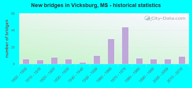
- New bridges - historical statistics
- 61900-1909
- 51910-1919
- 81920-1929
- 61930-1939
- 21940-1949
- 101950-1959
- 301960-1969
- 441970-1979
- 71980-1989
- 61990-1999
- 62000-2009
- 92010-2019

- Reconstructed bridges - Historical Statistics
- 11980-1989
- 01990-1999
- 02000-2009
- 12010-2019


- Bridge Condition - Deck
- 5.7%Very good
- 24.1%Good
- 32.2%Satisfactory
- 31.0%Fair
- 6.9%Poor

- Bridge Condition - Superstructure
- 13.0%Very good
- 41.3%Good
- 22.8%Satisfactory
- 18.5%Fair
- 4.3%Poor

- Bridge Condition - Substructure
- 10.9%Very good
- 38.0%Good
- 35.9%Satisfactory
- 14.1%Fair
- 1.1%Poor

- Bridge Condition - Channel
- 23.6%Very good
- 31.9%Good
- 30.6%Satisfactory
- 11.1%Fair
- 1.4%Poor
- 1.4%Serious

- Bridge Condition - Culverts
- 9.5%Very good
- 33.3%Good
- 47.6%Satisfactory
- 9.5%Fair
Find on map >> Show street view
Structure Number: 51000200750024A, Location: 2.4 MI E LA ST LINE (Lat: 32.319281, Lng: -90.877514), Route carried "on" structure: City street , Year Built: 1971, Status: Open, Structure Length: 11.19m (36.71ft), Average Daily Traffic: 8,500 (year 2020), Truck Traffic: 3%, Average Future Daily Traffic: 8,500 (year 2040), Design Load: HS 20, Features Intersected: I 20, Facility Carried by Structure: HALLS FERRY ROAD
Minimum Vertical Clearance: 30+ m (98+ ft), Kilometerpoint: 0.539, Lanes on structure: 2, Lanes under structure: 4, Base Highway Network: Yes (Inventory Route: 94, Subroute: 3), Owner: State Highway Agency, Approaching Roadway Width: 11.0m (36.1ft), Skew: 3 degrees, Material/Design: Prestressed concrete, Design/Construction: Stringer/Multi-beam, Number Of Spans In Main Unit: 4, Length of Maximum Span: 30.5m (100.1ft), Curb or Sidewalk Widths: Left: 0.3m (1.0ft), Right: 0.3m (1.0ft), Curb-To-Curb Width: 10.5m (34.4ft), Out-to-Out Width: 11.5m (37.7ft)
Condition: Deck: Satisfactory, Superstructure: Very good, Substructure: Satisfactory, Operating Rating: 86.8 metric tons, Method Used To Determine Operating Rating: Load Factor (LF), Inventory Rating: 57.2 metric tons, Method Used To Determine Inventory Rating: Load Factor (LF), Structural Evaluation: Equal to present minimum criteria, Deck Geometry: Somewhat better than minimum adequacy, Underclear: Superior to present desirable criteria, Approach Roadway Alignment: Equal to present desirable criteria, Designated Inspection Frequency: Every 24 months, Inspection Date: October 2021, Deck Structure Type: Concrete Cast-file-Place
Find on map >> Show street view
Structure Number: 51000200750024B, Location: 2.4 MI E LA ST LINE (Lat: 32.318319, Lng: -90.877283), Route carried "on" structure: City street , Year Built: 1971, Status: Open, Structure Length: 11.31m (37.11ft), Average Daily Traffic: 8,500 (year 2020), Truck Traffic: 3%, Average Future Daily Traffic: 8,500 (year 2040), Design Load: HS 20, Features Intersected: I 20, Facility Carried by Structure: HALLS FERRY ROAD
Minimum Vertical Clearance: 30+ m (98+ ft), Kilometerpoint: 15.678, Lanes on structure: 2, Lanes under structure: 4, Base Highway Network: Yes (Inventory Route: 94, Subroute: 1), Owner: State Highway Agency, Approaching Roadway Width: 11.0m (36.1ft), Skew: 3 degrees, Material/Design: Prestressed concrete, Design/Construction: Stringer/Multi-beam, Number Of Spans In Main Unit: 4, Length of Maximum Span: 30.5m (100.1ft), Curb or Sidewalk Widths: Left: 0.3m (1.0ft), Right: 0.3m (1.0ft), Curb-To-Curb Width: 10.5m (34.4ft), Out-to-Out Width: 11.4m (37.4ft)
Condition: Deck: Satisfactory, Superstructure: Very good, Substructure: Good, Operating Rating: 86.8 metric tons, Method Used To Determine Operating Rating: Load Factor (LF), Inventory Rating: 57.2 metric tons, Method Used To Determine Inventory Rating: Load Factor (LF), Structural Evaluation: Better than present minimum criteria, Deck Geometry: Somewhat better than minimum adequacy, Underclear: Equal to present minimum criteria, Approach Roadway Alignment: Equal to present desirable criteria, Designated Inspection Frequency: Every 24 months, Inspection Date: October 2021, Deck Structure Type: Concrete Cast-file-Place
Find on map >> Show street view
Structure Number: 51000200750029, Location: 2.9 MI E LA ST LINE (Lat: 32.322111, Lng: -90.868422), Route carried "on" structure: City street , Year Built: 1971, Status: Open, Structure Length: 15.00m (49.21ft), Average Daily Traffic: 3,800 (year 2020), Truck Traffic: 8%, Average Future Daily Traffic: 3,800 (year 2040), Design Load: HS 20, Features Intersected: I 20, Facility Carried by Structure: WISCONSIN AVE
Minimum Vertical Clearance: 30+ m (98+ ft), Kilometerpoint: 2.086, Lanes on structure: 2, Lanes under structure: 4, Owner: State Highway Agency, Approaching Roadway Width: 11.0m (36.1ft), Skew: 1 degrees, Material/Design: Prestressed concrete, Design/Construction: Stringer/Multi-beam, Number Of Spans In Main Unit: 7, Length of Maximum Span: 27.4m (89.9ft), Curb or Sidewalk Widths: Left: 0.3m (1.0ft), Right: 0.3m (1.0ft), Curb-To-Curb Width: 9.1m (29.9ft), Out-to-Out Width: 10.1m (33.1ft)
Condition: Deck: Fair, Superstructure: Satisfactory, Substructure: Satisfactory, Operating Rating: 75.0 metric tons, Method Used To Determine Operating Rating: Load Factor (LF), Inventory Rating: 49.3 metric tons, Method Used To Determine Inventory Rating: Load Factor (LF), Structural Evaluation: Equal to present minimum criteria, Deck Geometry: Meets minimum limits, Underclear: Better than present minimum criteria, Approach Roadway Alignment: Equal to present desirable criteria, Designated Inspection Frequency: Every 24 months, Inspection Date: October 2021, Deck Structure Type: Concrete Cast-file-Place
Find on map >> Show street view
Structure Number: 51000200750035, Location: 3.5 MI E LA ST LINE (Lat: 32.330103, Lng: -90.861731), Route carried "on" structure: City street , Year Built: 1971, Status: Open, Structure Length: 9.81m (32.19ft), Average Daily Traffic: 9,600 (year 2020), Truck Traffic: 6%, Average Future Daily Traffic: 9,600 (year 2040), Design Load: HS 20, Features Intersected: I 20, Facility Carried by Structure: INDIANA AVE
Minimum Vertical Clearance: 30+ m (98+ ft), Kilometerpoint: 0.756, Lanes on structure: 2, Lanes under structure: 4, Owner: State Highway Agency, Approaching Roadway Width: 11.0m (36.1ft), Skew: 1 degrees, Material/Design: Prestressed concrete, Design/Construction: Stringer/Multi-beam, Number Of Spans In Main Unit: 4, Length of Maximum Span: 27.4m (89.9ft), Curb or Sidewalk Widths: Left: 0.3m (1.0ft), Right: 0.3m (1.0ft), Curb-To-Curb Width: 25.1m (82.3ft), Out-to-Out Width: 26.2m (86.0ft)
Condition: Deck: Satisfactory, Superstructure: Satisfactory, Substructure: Good, Inventory Rating: 69.3 metric tons, Method Used To Determine Inventory Rating: Load Factor (LF), Structural Evaluation: Equal to present minimum criteria, Deck Geometry: Superior to present desirable criteria, Underclear: Somewhat better than minimum adequacy, Approach Roadway Alignment: Equal to present desirable criteria, Designated Inspection Frequency: Every 24 months, Inspection Date: October 2021, Deck Structure Type: Concrete Cast-file-Place, Wearing Surface/Protective System: Wearing Surface: Monolithic Concrete
Find on map >> Show street view
Structure Number: 5600001P, Location: 0.2 MILES NORTH FROM U.S. (Lat: 32.344889, Lng: -90.847131), Route carried "on" structure: Federal lands road 500, Year Built: 1904, Status: Open, Structure Length: 0.91m (2.99ft), Average Daily Traffic: 3,040 (year 2010), Average Future Daily Traffic: 3,344 (year 2030), Design Load: H 15, Features Intersected: STREAM, Facility Carried by Structure: UNION AVENUE
Minimum Vertical Clearance: 30+ m (98+ ft), Kilometerpoint: 0.241, Lanes on structure: 2, Owner: National Park Service, Approaching Roadway Width: 7.6m (24.9ft), Material/Design: Concrete, Design/Construction: Arch - Deck, Number Of Spans In Main Unit: 1, Length of Maximum Span: 9.1m (29.9ft), Curb-To-Curb Width: 6.3m (20.7ft), Out-to-Out Width: 7.5m (24.6ft)
Condition: Superstructure: Satisfactory, Substructure: Good, Channel: Satisfactory, Operating Rating: 35.4 metric tons, Method Used To Determine Operating Rating: Field evaluation and documented engineering judgment, Inventory Rating: 20.9 metric tons, Method Used To Determine Inventory Rating: Field evaluation and documented engineering judgment, Structural Evaluation: Somewhat better than minimum adequacy, Deck Geometry: High priority of replacement, Waterway Adequacy: Equal to present desirable criteria, Approach Roadway Alignment: Equal to present desirable criteria, Designated Inspection Frequency: Every 24 months, Inspection Date: October 2020, Bridge Improvement Cost: $100,000, Roadway Improvement Cost: $10,000, Total Project Cost: $150,000 ( Estimate for 2018)
Find on map >> Show street view
Structure Number: 5600002P, Location: 1.2 MILES FROM U.S. ROUTE (Lat: 32.355119, Lng: -90.842169), Route carried "on" structure: Federal lands road 500, Year Built: 1904, Status: Open, Structure Length: 0.73m (2.40ft), Average Daily Traffic: 3,040 (year 2010), Average Future Daily Traffic: 3,344 (year 2030), Design Load: H 15, Features Intersected: STREAM, Facility Carried by Structure: UNION AVENUE
Minimum Vertical Clearance: 30+ m (98+ ft), Kilometerpoint: 1.722, Lanes on structure: 2, Owner: National Park Service, Approaching Roadway Width: 5.8m (19.0ft), Material/Design: Concrete, Design/Construction: Arch - Deck, Number Of Spans In Main Unit: 1, Length of Maximum Span: 7.3m (24.0ft), Curb-To-Curb Width: 6.4m (21.0ft), Out-to-Out Width: 7.6m (24.9ft)
Condition: Superstructure: Fair, Substructure: Satisfactory, Channel: Serious, Operating Rating: 39.9 metric tons, Method Used To Determine Operating Rating: Field evaluation and documented engineering judgment, Inventory Rating: 23.6 metric tons, Method Used To Determine Inventory Rating: Field evaluation and documented engineering judgment, Structural Evaluation: Somewhat better than minimum adequacy, Deck Geometry: High priority of replacement, Waterway Adequacy: Equal to present desirable criteria, Approach Roadway Alignment: Equal to present desirable criteria, Designated Inspection Frequency: Every 24 months, Inspection Date: October 2020, Bridge Improvement Cost: $300,000, Roadway Improvement Cost: $30,000, Total Project Cost: $450,000 ( Estimate for 2018)
Find on map >> Show street view
Structure Number: 5600003P, Location: 2.2 MILES FROM U.S. ROUTE (Lat: 32.363169, Lng: -90.840319), Route carried "on" structure: Federal lands road 500, Year Built: 1970, Status: Open, Structure Length: 6.49m (21.29ft), Average Daily Traffic: 3,040 (year 2010), Average Future Daily Traffic: 3,344 (year 2030), Design Load: H 15, Features Intersected: JACKSON ROAD AND STREAM, Facility Carried by Structure: UNION AVENUE
Minimum Vertical Clearance: 30+ m (98+ ft), Kilometerpoint: 3.299, Lanes on structure: 2, Lanes under structure: 2, Owner: National Park Service, Approaching Roadway Width: 9.8m (32.2ft), Material/Design: Prestressed concrete continuous, Design/Construction: Stringer/Multi-beam, Number Of Spans In Main Unit: 4, Length of Maximum Span: 21.9m (71.9ft), Curb-To-Curb Width: 6.7m (22.0ft), Out-to-Out Width: 8.0m (26.2ft)
Condition: Deck: Good, Superstructure: Good, Substructure: Good, Channel: Satisfactory, Operating Rating: 48.1 metric tons, Method Used To Determine Operating Rating: Load Factor (LF), Inventory Rating: 18.1 metric tons, Method Used To Determine Inventory Rating: Load Factor (LF), Structural Evaluation: Somewhat better than minimum adequacy, Deck Geometry: High priority of replacement, Underclear: Meets minimum limits, Approach Roadway Alignment: Equal to present desirable criteria, Designated Inspection Frequency: Every 24 months, Inspection Date: October 2020, Bridge Improvement Cost: $15,000, Roadway Improvement Cost: $5,000, Total Project Cost: $20,000 ( Estimate for 2018), Deck Structure Type: Concrete Cast-file-Place, Wearing Surface/Protective System: Wearing Surface: Bituminous
Find on map >> Show street view
Structure Number: 5600004P, Location: 1.3 MILES BEFORE VICKSBUR (Lat: 32.374269, Lng: -90.851289), Route carried "on" structure: Federal lands road 500, Year Built: 1904, Status: Open, Structure Length: 1.22m (4.00ft), Average Daily Traffic: 3,040 (year 2010), Average Future Daily Traffic: 3,344 (year 2030), Design Load: H 15, Features Intersected: STREAM, Facility Carried by Structure: UNION AVENUE
Minimum Vertical Clearance: 30+ m (98+ ft), Kilometerpoint: 10.300, Lanes on structure: 2, Owner: National Park Service, Approaching Roadway Width: 5.3m (17.4ft), Material/Design: Concrete, Design/Construction: Arch - Deck, Number Of Spans In Main Unit: 1, Length of Maximum Span: 12.2m (40.0ft), Curb or Sidewalk Widths: Left: 0.5m (1.6ft), Right: 0.5m (1.6ft), Curb-To-Curb Width: 6.2m (20.3ft), Out-to-Out Width: 7.4m (24.3ft)
Condition: Superstructure: Fair, Substructure: Satisfactory, Channel: Fair, Operating Rating: 32.7 metric tons, Method Used To Determine Operating Rating: Field evaluation and documented engineering judgment, Inventory Rating: 19.0 metric tons, Method Used To Determine Inventory Rating: Field evaluation and documented engineering judgment, Structural Evaluation: Somewhat better than minimum adequacy, Deck Geometry: High priority of replacement, Waterway Adequacy: Equal to present desirable criteria, Approach Roadway Alignment: Equal to present minimum criteria, Designated Inspection Frequency: Every 24 months, Inspection Date: October 2020, Bridge Improvement Cost: $110,000, Roadway Improvement Cost: $11,000, Total Project Cost: $165,000 ( Estimate for 2018)
Find on map >> Show street view
Structure Number: 5600005P, Location: 1.1 MILES BEFORE VICKSBUR (Lat: 32.375000, Lng: -90.853019), Route carried "on" structure: Federal lands road 500, Year Built: 1904, Status: Open, Structure Length: 0.70m (2.30ft), Average Daily Traffic: 3,040 (year 2010), Average Future Daily Traffic: 3,344 (year 2030), Design Load: H 15, Features Intersected: STREAM, Facility Carried by Structure: UNION AVENUE
Minimum Vertical Clearance: 30+ m (98+ ft), Kilometerpoint: 10.783, Lanes on structure: 1, Owner: National Park Service, Approaching Roadway Width: 5.2m (17.1ft), Material/Design: Concrete, Design/Construction: Arch - Deck, Number Of Spans In Main Unit: 1, Length of Maximum Span: 7.0m (23.0ft), Curb or Sidewalk Widths: Left: 0.5m (1.6ft), Right: 0.5m (1.6ft), Curb-To-Curb Width: 5.9m (19.4ft), Out-to-Out Width: 7.3m (24.0ft)
Condition: Superstructure: Satisfactory, Substructure: Very good, Channel: Satisfactory, Operating Rating: 32.7 metric tons, Method Used To Determine Operating Rating: Field evaluation and documented engineering judgment, Inventory Rating: 24.5 metric tons, Method Used To Determine Inventory Rating: Field evaluation and documented engineering judgment, Structural Evaluation: Equal to present minimum criteria, Deck Geometry: High priority of replacement, Waterway Adequacy: Equal to present desirable criteria, Approach Roadway Alignment: Equal to present desirable criteria, Designated Inspection Frequency: Every 24 months, Inspection Date: October 2020, Bridge Improvement Cost: $105,000, Roadway Improvement Cost: $11,000, Total Project Cost: $160,000 ( Estimate for 2018)
Find on map >> Show street view
Structure Number: 5600007P, Location: 4.3 MILES FROM U.S. ROUTE (Lat: 32.372631, Lng: -90.867469), Route carried "on" structure: Federal lands road 10, Year Built: 1962, Status: Open, Structure Length: 1.16m (3.81ft), Average Daily Traffic: 3,800 (year 2010), Average Future Daily Traffic: 4,180 (year 2030), Features Intersected: MINT SPRING BAYOU, Facility Carried by Structure: CONNECTING AVENUE
Minimum Vertical Clearance: 30+ m (98+ ft), Kilometerpoint: 13.840, Lanes on structure: 2, Owner: National Park Service, Approaching Roadway Width: 8.5m (27.9ft), Skew: 3 degrees, Material/Design: Concrete, Design/Construction: Frame, Number Of Spans In Main Unit: 1, Length of Maximum Span: 11.6m (38.1ft), Curb-To-Curb Width: 7.2m (23.6ft), Out-to-Out Width: 9.4m (30.8ft)
Condition: Deck: Good, Superstructure: Good, Substructure: Good, Channel: Good, Operating Rating: 32.7 metric tons, Method Used To Determine Operating Rating: Field evaluation and documented engineering judgment, Inventory Rating: 21.8 metric tons, Method Used To Determine Inventory Rating: Field evaluation and documented engineering judgment, Structural Evaluation: Somewhat better than minimum adequacy, Deck Geometry: High priority of replacement, Waterway Adequacy: Equal to present desirable criteria, Approach Roadway Alignment: Equal to present desirable criteria, Designated Inspection Frequency: Every 24 months, Inspection Date: October 2020, Bridge Improvement Cost: $35,000, Roadway Improvement Cost: $4,000, Total Project Cost: $55,000 ( Estimate for 2018), Deck Structure Type: Concrete Cast-file-Place, Wearing Surface/Protective System: Wearing Surface: Bituminous
Find on map >> Show street view
Structure Number: 5600008P, Location: 0.5 MILES BEFORE PEMBERTO (Lat: 32.361619, Lng: -90.846481), Route carried "on" structure: Federal lands road 12, Year Built: 1970, Status: Open, Structure Length: 13.41m (44.00ft), Average Daily Traffic: 3,420 (year 2010), Average Future Daily Traffic: 3,762 (year 2030), Design Load: H 15, Features Intersected: JACKSON ROAD AND STREAM, Facility Carried by Structure: CONFEDERATE AVENUE
Minimum Vertical Clearance: 30+ m (98+ ft), Kilometerpoint: 18.186, Lanes on structure: 2, Lanes under structure: 2, Owner: National Park Service, Approaching Roadway Width: 7.0m (23.0ft), Skew: 3 degrees, Material/Design: Concrete continuous, Design/Construction: Box Beam or Girders - Single/Spread, Number Of Spans In Main Unit: 5, Length of Maximum Span: 30.5m (100.1ft), Curb-To-Curb Width: 6.7m (22.0ft), Out-to-Out Width: 8.1m (26.6ft)
Condition: Deck: Good, Superstructure: Good, Substructure: Good, Channel: Satisfactory, Operating Rating: 61.7 metric tons, Method Used To Determine Operating Rating: Load Factor (LF), Inventory Rating: 36.3 metric tons, Method Used To Determine Inventory Rating: Load Factor (LF), Structural Evaluation: Better than present minimum criteria, Deck Geometry: High priority of replacement, Underclear: Meets minimum limits, Waterway Adequacy: Equal to present desirable criteria, Approach Roadway Alignment: Equal to present desirable criteria, Designated Inspection Frequency: Every 24 months, Inspection Date: October 2020, Bridge Improvement Cost: $43,000, Roadway Improvement Cost: $5,000, Total Project Cost: $80,000 ( Estimate for 2018), Deck Structure Type: Concrete Cast-file-Place, Wearing Surface/Protective System: Wearing Surface: Bituminous
Find on map >> Show street view
Structure Number: 5600010P, Location: 0.1 MILES SOUTH OF CONFED (Lat: 32.342369, Lng: -90.851931), Route carried "on" structure: Federal lands road 12, Year Built: 1972, Status: Open, Structure Length: 2.96m (9.71ft), Average Daily Traffic: 3,420 (year 2010), Average Future Daily Traffic: 3,762 (year 2030), Design Load: H 15, Features Intersected: HISTORIC SOUTHERN RR OF, Facility Carried by Structure: UNION AVENUE
Minimum Vertical Clearance: 30+ m (98+ ft), Kilometerpoint: 21.243, Lanes on structure: 2, Owner: National Park Service, Approaching Roadway Width: 6.6m (21.7ft), Material/Design: Concrete continuous, Design/Construction: Slab, Number Of Spans In Main Unit: 3, Length of Maximum Span: 12.2m (40.0ft), Curb-To-Curb Width: 7.9m (25.9ft), Out-to-Out Width: 9.2m (30.2ft)
Condition: Deck: Satisfactory, Superstructure: Satisfactory, Substructure: Satisfactory, Operating Rating: 50.8 metric tons, Method Used To Determine Operating Rating: Load Factor (LF), Inventory Rating: 29.9 metric tons, Method Used To Determine Inventory Rating: Load Factor (LF), Structural Evaluation: Equal to present minimum criteria, Deck Geometry: High priority of corrective action, Underclear: Equal to present minimum criteria, Approach Roadway Alignment: Equal to present desirable criteria, Designated Inspection Frequency: Every 24 months, Inspection Date: October 2020, Bridge Improvement Cost: $140,000, Roadway Improvement Cost: $14,000, Total Project Cost: $210,000 ( Estimate for 2018), Deck Structure Type: Concrete Cast-file-Place, Wearing Surface/Protective System: Wearing Surface: Bituminous
Find on map >> Show street view
Structure Number: 5600014P, Location: 2.0 MILES FROM U.S. ROUTE (Lat: 32.338500, Lng: -90.856381), Route carried "on" structure: Federal lands road 501, Year Built: 1904, Status: Open, Structure Length: 0.79m (2.59ft), Average Daily Traffic: 3,040 (year 2010), Average Future Daily Traffic: 3,344 (year 2030), Design Load: H 15, Features Intersected: STREAM, Facility Carried by Structure: UNION AVENUE
Minimum Vertical Clearance: 30+ m (98+ ft), Kilometerpoint: 24.301, Lanes on structure: 2, Owner: National Park Service, Approaching Roadway Width: 5.0m (16.4ft), Material/Design: Concrete, Design/Construction: Arch - Deck, Number Of Spans In Main Unit: 1, Length of Maximum Span: 7.9m (25.9ft), Curb or Sidewalk Widths: Left: 0.6m (2.0ft), Right: 0.6m (2.0ft), Curb-To-Curb Width: 4.9m (16.1ft), Out-to-Out Width: 7.2m (23.6ft)
Condition: Superstructure: Fair, Substructure: Fair, Channel: Poor, Operating Rating: 32.7 metric tons, Method Used To Determine Operating Rating: Load Factor (LF), Inventory Rating: 19.0 metric tons, Method Used To Determine Inventory Rating: Load Factor (LF), Structural Evaluation: Somewhat better than minimum adequacy, Deck Geometry: High priority of replacement, Waterway Adequacy: Equal to present minimum criteria, Approach Roadway Alignment: Equal to present desirable criteria, Designated Inspection Frequency: Every 24 months, Inspection Date: October 2020, Bridge Improvement Cost: $90,000, Roadway Improvement Cost: $9,000, Total Project Cost: $130,000 ( Estimate for 2018)
Find on map >> Show street view
Structure Number: CEPERDMS0000001, Location: SOUTH OF WABASH ROAD (Lat: 32.306031, Lng: -90.864242), Route carried "on" structure: Federal lands road , Year Built: 1960, Status: Posted for load, Structure Length: 0.94m (3.08ft), Average Daily Traffic: 400 (year 2020), Truck Traffic: 5%, Average Future Daily Traffic: 500 (year 2040), Features Intersected: DURDEN CREEK, Facility Carried by Structure: OHIO ROAD
Minimum Vertical Clearance: 30+ m (98+ ft), Kilometerpoint: 0.000, Lanes on structure: 2, Owner: Corps of Engineers (Civil), Approaching Roadway Width: 7.1m (23.3ft), Material/Design: Prestressed concrete, Design/Construction: Channel Beam, Number Of Spans In Main Unit: 1, Length of Maximum Span: 9.1m (29.9ft), Curb or Sidewalk Widths: Left: 0.2m (0.7ft), Right: 0.2m (0.7ft), Curb-To-Curb Width: 7.1m (23.3ft), Out-to-Out Width: 7.5m (24.6ft)
Condition: Deck: Good, Superstructure: Satisfactory, Substructure: Satisfactory, Channel: Fair, Operating Rating: 16.5 metric tons, Method Used To Determine Operating Rating: Load and Resistance Factor Rating (LRFR) rating reported by rating factor(RF) method using HL-93 loadings, Inventory Rating: 12.6 metric tons, Method Used To Determine Inventory Rating: Load and Resistance Factor Rating (LRFR) rating reported by rating factor(RF) method using HL-93 loadings, Structural Evaluation: Meets minimum limits, Deck Geometry: Meets minimum limits, Waterway Adequacy: Better than present minimum criteria, Approach Roadway Alignment: Equal to present minimum criteria, Bridge Posting: Required (Relationship of Operating Rating to Maximum Legal Load: > 39.9% below), Length Of Structure Improvement: 1.86m (6.10ft), Designated Inspection Frequency: Every 24 months, Inspection Date: March 2020, Bridge Improvement Cost: $69,000, Roadway Improvement Cost: $7,000, Total Project Cost: $104,000 ( Estimate for 2020), Deck Structure Type: Other, Wearing Surface/Protective System: Wearing Surface: Bituminous
Find on map >> Show street view
Structure Number: CEPERDMS0000002, Location: BETWEEN B-1008 & B-2026 (Lat: 32.296731, Lng: -90.869642), Route carried "on" structure: Federal lands road , Year Built: 1940, Status: Posted for load, Structure Length: 2.03m (6.66ft), Average Daily Traffic: 500 (year 2020), Truck Traffic: 10%, Average Future Daily Traffic: 1,100 (year 2036), Features Intersected: DURDEN CREEK SPILLWAY, Facility Carried by Structure: CHESAPEAKE ROAD
Minimum Vertical Clearance: 30+ m (98+ ft), Kilometerpoint: 0.000, Lanes on structure: 2, Owner: Corps of Engineers (Civil), Approaching Roadway Width: 6.7m (22.0ft), Material/Design: Steel, Design/Construction: Stringer/Multi-beam, Number Of Spans In Main Unit: 1, Number Of Approach Spans: 2, Length of Maximum Span: 9.7m (31.8ft), Curb or Sidewalk Widths: Left: 0.7m (2.3ft), Right: 0.7m (2.3ft), Curb-To-Curb Width: 6.7m (22.0ft), Out-to-Out Width: 8.8m (28.9ft)
Condition: Deck: Satisfactory, Superstructure: Good, Substructure: Fair, Channel: Fair, Operating Rating: 18.8 metric tons, Method Used To Determine Operating Rating: Load and Resistance Factor Rating (LRFR) rating reported by rating factor(RF) method using HL-93 loadings, Inventory Rating: 14.6 metric tons, Method Used To Determine Inventory Rating: Load and Resistance Factor Rating (LRFR) rating reported by rating factor(RF) method using HL-93 loadings, Structural Evaluation: Meets minimum limits, Deck Geometry: Meets minimum limits, Waterway Adequacy: Superior to present desirable criteria, Approach Roadway Alignment: Equal to present desirable criteria, Bridge Posting: Required (Relationship of Operating Rating to Maximum Legal Load: 30.0 - 39.9% below), Length Of Structure Improvement: 3.96m (12.99ft), Designated Inspection Frequency: Every 24 months, Inspection Date: March 2020, Bridge Improvement Cost: $175,000, Roadway Improvement Cost: $18,000, Total Project Cost: $263,000 ( Estimate for 2020), Deck Structure Type: Concrete Cast-file-Place
Find on map >> Show street view
Structure Number: CEPERDMS0000003, Location: BETWEEN B-4005 & B-4006 (Lat: 32.305117, Lng: -90.870092), Route carried "on" structure: Federal lands road , Year Built: 1960, Status: Posted for load, Structure Length: 0.92m (3.02ft), Average Daily Traffic: 12 (year 2020), Truck Traffic: 10%, Average Future Daily Traffic: 20 (year 2038), Features Intersected: STORMDRAIN TO BROWN LAKE, Facility Carried by Structure: TENNESSEE ROAD
Minimum Vertical Clearance: 30+ m (98+ ft), Kilometerpoint: 0.000, Lanes on structure: 2, Owner: Corps of Engineers (Civil), Approaching Roadway Width: 4.9m (16.1ft), Material/Design: Steel, Design/Construction: Stringer/Multi-beam, Number Of Spans In Main Unit: 1, Length of Maximum Span: 9.1m (29.9ft), Curb-To-Curb Width: 6.0m (19.7ft), Out-to-Out Width: 7.0m (23.0ft)
Condition: Deck: Fair, Superstructure: Fair, Substructure: Satisfactory, Channel: Fair, Operating Rating: 21.4 metric tons, Method Used To Determine Operating Rating: Load and Resistance Factor Rating (LRFR) rating reported by rating factor(RF) method using HL-93 loadings, Inventory Rating: 16.5 metric tons, Method Used To Determine Inventory Rating: Load and Resistance Factor Rating (LRFR) rating reported by rating factor(RF) method using HL-93 loadings, Structural Evaluation: Somewhat better than minimum adequacy, Deck Geometry: Meets minimum limits, Waterway Adequacy: Equal to present desirable criteria, Approach Roadway Alignment: Equal to present minimum criteria, Bridge Posting: Required (Relationship of Operating Rating to Maximum Legal Load: > 39.9% below), Length Of Structure Improvement: 1.81m (5.94ft), Designated Inspection Frequency: Every 24 months, Inspection Date: March 2020, Bridge Improvement Cost: $64,000, Roadway Improvement Cost: $6,000, Total Project Cost: $96,000 ( Estimate for 2020), Deck Structure Type: Concrete Cast-file-Place
Find on map >> Show street view
Structure Number: SA7500000000001, Location: SEC 6 T 6N R 4W B (Lat: 32.389167, Lng: -90.650333), Route carried "on" structure: County highway 62, Year Built: 1986, Status: Open, Structure Length: 3.66m (12.01ft), Average Daily Traffic: 121 (year 2021), Truck Traffic: 8%, Average Future Daily Traffic: 165 (year 2043), Design Load: H 15, Features Intersected: SUMER SEAT CREEK, Facility Carried by Structure: YOUNGSTOWN ROAD
Minimum Vertical Clearance: 30+ m (98+ ft), Kilometerpoint: 4.828, Lanes on structure: 2, Owner: County Highway Agency, Approaching Roadway Width: 6.1m (20.0ft), Material/Design: Prestressed concrete, Design/Construction: Stringer/Multi-beam, Number Of Spans In Main Unit: 3, Length of Maximum Span: 12.2m (40.0ft), Curb-To-Curb Width: 8.5m (27.9ft), Out-to-Out Width: 9.4m (30.8ft)
Condition: Deck: Good, Superstructure: Very good, Substructure: Fair, Channel: Fair, Operating Rating: 62.4 metric tons, Method Used To Determine Operating Rating: Load Factor (LF), Inventory Rating: 37.5 metric tons, Method Used To Determine Inventory Rating: Load Factor (LF), Structural Evaluation: Somewhat better than minimum adequacy, Deck Geometry: Equal to present minimum criteria, Waterway Adequacy: Superior to present desirable criteria, Approach Roadway Alignment: Better than present minimum criteria, Length Of Structure Improvement: 4.58m (15.03ft), Designated Inspection Frequency: Every 24 months, Inspection Date: March 2021, Bridge Improvement Cost: $464,000, Roadway Improvement Cost: $372,000, Total Project Cost: $836,000 ( Estimate for 2021), Deck Structure Type: Concrete Cast-file-Place
Find on map >> Show street view
Structure Number: SA7500000000008, Location: SEC 2 T14N R 3E B (Lat: 32.212889, Lng: -90.891417), Route carried "on" structure: County highway 17, Year Built: 2009, Status: Open, Structure Length: 3.66m (12.01ft), Average Daily Traffic: 660 (year 2020), Truck Traffic: 8%, Average Future Daily Traffic: 858 (year 2042), Design Load: HS 20, Features Intersected: REDBONE CREEK, Facility Carried by Structure: REDBONE ROAD
Minimum Vertical Clearance: 30+ m (98+ ft), Kilometerpoint: 10.460, Lanes on structure: 2, Owner: County Highway Agency, Approaching Roadway Width: 6.7m (22.0ft), Material/Design: Concrete, Design/Construction: Channel Beam, Number Of Spans In Main Unit: 3, Length of Maximum Span: 12.2m (40.0ft), Curb-To-Curb Width: 8.7m (28.5ft), Out-to-Out Width: 9.4m (30.8ft)
Condition: Deck: Good, Superstructure: Very good, Substructure: Good, Channel: Good, Operating Rating: 40.8 metric tons, Method Used To Determine Operating Rating: Load Factor (LF) rating reported by rating factor (RF) method using MS18 loading, Inventory Rating: 24.3 metric tons, Method Used To Determine Inventory Rating: Load Factor (LF) rating reported by rating factor (RF) method using MS18 loading, Structural Evaluation: Equal to present minimum criteria, Deck Geometry: Somewhat better than minimum adequacy, Waterway Adequacy: Superior to present desirable criteria, Approach Roadway Alignment: Equal to present minimum criteria, Length Of Structure Improvement: 5.49m (18.01ft), Designated Inspection Frequency: Every 24 months, Inspection Date: October 2020, Bridge Improvement Cost: $278,000, Roadway Improvement Cost: $223,000, Total Project Cost: $501,000 ( Estimate for 2020), Deck Structure Type: Concrete Precast Panels
Find on map >> Show street view
Structure Number: SA7500000000009, Location: SEC 2 T14N R 3E (Lat: 32.218083, Lng: -90.883556), Route carried "on" structure: County highway 269, Year Built: 2010, Status: Open, Structure Length: 3.70m (12.14ft), Average Daily Traffic: 235 (year 2021), Truck Traffic: 8%, Average Future Daily Traffic: 306 (year 2043), Design Load: HS 20, Features Intersected: REDBONE CREEK, Facility Carried by Structure: MALLETT ROAD
Minimum Vertical Clearance: 30+ m (98+ ft), Kilometerpoint: 2.092, Lanes on structure: 2, Owner: County Highway Agency, Approaching Roadway Width: 6.4m (21.0ft), Material/Design: Concrete, Design/Construction: Channel Beam, Number Of Spans In Main Unit: 3, Length of Maximum Span: 12.2m (40.0ft), Curb-To-Curb Width: 8.6m (28.2ft), Out-to-Out Width: 9.5m (31.2ft)
Condition: Deck: Very good, Superstructure: Good, Substructure: Good, Channel: Satisfactory, Operating Rating: 81.4 metric tons, Method Used To Determine Operating Rating: Load Factor (LF), Inventory Rating: 48.7 metric tons, Method Used To Determine Inventory Rating: Load Factor (LF), Structural Evaluation: Better than present minimum criteria, Deck Geometry: Equal to present minimum criteria, Waterway Adequacy: Superior to present desirable criteria, Approach Roadway Alignment: Equal to present minimum criteria, Length Of Structure Improvement: 4.63m (15.19ft), Designated Inspection Frequency: Every 24 months, Inspection Date: March 2021, Bridge Improvement Cost: $476,000, Roadway Improvement Cost: $381,000, Total Project Cost: $857,000 ( Estimate for 2021), Deck Structure Type: Concrete Precast Panels
Find on map >> Show street view
Structure Number: SA7500000000018, Location: SEC 4 T15N R 3E (Lat: 32.300250, Lng: -90.899000), Route carried "on" structure: City street 182, Year Built: 1984, Status: Open, Structure Length: 3.37m (11.06ft), Average Daily Traffic: 451 (year 2021), Truck Traffic: 8%, Average Future Daily Traffic: 615 (year 2043), Design Load: HS 20, Features Intersected: STOUTS BAYOU, Facility Carried by Structure: RIFLE RANGE ROAD
Minimum Vertical Clearance: 30+ m (98+ ft), Kilometerpoint: 0.804, Lanes on structure: 2, Owner: City or Municipal Highway Agency, Approaching Roadway Width: 7.6m (24.9ft), Skew: 4 degrees, Material/Design: Concrete continuous, Design/Construction: Slab, Number Of Spans In Main Unit: 3, Length of Maximum Span: 12.6m (41.3ft), Curb-To-Curb Width: 9.1m (29.9ft), Out-to-Out Width: 10.0m (32.8ft)
Condition: Deck: Satisfactory, Superstructure: Satisfactory, Substructure: Good, Channel: Good, Operating Rating: 54.6 metric tons, Method Used To Determine Operating Rating: Load Factor (LF), Inventory Rating: 32.7 metric tons, Method Used To Determine Inventory Rating: Load Factor (LF), Structural Evaluation: Equal to present minimum criteria, Deck Geometry: Equal to present minimum criteria, Waterway Adequacy: Better than present minimum criteria, Approach Roadway Alignment: Equal to present minimum criteria, Length Of Structure Improvement: 4.25m (13.94ft), Designated Inspection Frequency: Every 24 months, Inspection Date: March 2021, Bridge Improvement Cost: $459,000, Roadway Improvement Cost: $368,000, Total Project Cost: $827,000 ( Estimate for 2021), Deck Structure Type: Concrete Cast-file-Place
Find on map >> Show street view
Structure Number: SA750000000002, Location: SEC 13 T15N R 3E B (Lat: 32.289000, Lng: -90.868472), Route carried "on" structure: County highway 403, Year Built: 1963, Status: Posted for load, Structure Length: 6.71m (22.01ft), Average Daily Traffic: 7,595 (year 2020), Truck Traffic: 8%, Average Future Daily Traffic: 9,874 (year 2042), Design Load: H 15, Features Intersected: HATCHERS BAYOU, Facility Carried by Structure: FISHER FERRY ROAD
Minimum Vertical Clearance: 30+ m (98+ ft), Kilometerpoint: 21.887, Lanes on structure: 2, Owner: County Highway Agency, Approaching Roadway Width: 6.7m (22.0ft), Material/Design: Steel, Design/Construction: Stringer/Multi-beam, Number Of Spans In Main Unit: 1, Number Of Approach Spans: 9, Length of Maximum Span: 12.2m (40.0ft), Curb or Sidewalk Widths: Left: 0.5m (1.6ft), Right: 0.5m (1.6ft), Curb-To-Curb Width: 7.3m (24.0ft), Out-to-Out Width: 8.4m (27.6ft)
Condition: Deck: Satisfactory, Superstructure: Good, Substructure: Good, Channel: Good, Operating Rating: 29.5 metric tons, Method Used To Determine Operating Rating: Load Factor (LF), Inventory Rating: 17.7 metric tons, Method Used To Determine Inventory Rating: Load Factor (LF), Structural Evaluation: Meets minimum limits, Deck Geometry: High priority of replacement, Waterway Adequacy: Better than present minimum criteria, Approach Roadway Alignment: Better than present minimum criteria, Bridge Posting: Required (Relationship of Operating Rating to Maximum Legal Load: 20.0 - 29.9% below), Length Of Structure Improvement: 10.07m (33.04ft), Designated Inspection Frequency: Every 24 months, Inspection Date: December 2020, Bridge Improvement Cost: $995,000, Roadway Improvement Cost: $796,000, Total Project Cost: $1,791,000 ( Estimate for 2020), Deck Structure Type: Concrete Cast-file-Place
Find on map >> Show street view
Structure Number: SA7500000000021, Location: SEC 13 T15N R 3E (Lat: 32.295556, Lng: -90.871056), Route carried "on" structure: City street 9654, Year Built: 1946, Status: Open, Structure Length: 1.00m (3.28ft), Average Daily Traffic: 10,321 (year 2021), Truck Traffic: 8%, Average Future Daily Traffic: 15,482 (year 2043), Design Load: HS 20, Features Intersected: DURDEN CREEK, Facility Carried by Structure: HALLS FERRY ROAD
Minimum Vertical Clearance: 30+ m (98+ ft), Kilometerpoint: 0.800, Lanes on structure: 2, Owner: City or Municipal Highway Agency, Approaching Roadway Width: 10.4m (34.1ft), Material/Design: Concrete, Design/Construction: Culvert, Number Of Spans In Main Unit: 2, Length of Maximum Span: 4.9m (16.1ft)
Condition: Channel: Satisfactory, Culverts: Fair, Operating Rating: 32.7 metric tons, Method Used To Determine Operating Rating: Field evaluation and documented engineering judgment, Inventory Rating: 32.7 metric tons, Method Used To Determine Inventory Rating: Field evaluation and documented engineering judgment, Structural Evaluation: Somewhat better than minimum adequacy, Waterway Adequacy: Better than present minimum criteria, Approach Roadway Alignment: Better than present minimum criteria, Bridge Posting: Required (Relationship of Operating Rating to Maximum Legal Load: 10.0 - 19.9% below), Length Of Structure Improvement: 1.67m (5.48ft), Designated Inspection Frequency: Every 24 months, Inspection Date: May 2021, Bridge Improvement Cost: $187,000, Roadway Improvement Cost: $150,000, Total Project Cost: $337,000 ( Estimate for 2021)
Find on map >> Show street view
Structure Number: SA7500000000023, Location: SEC 25 T15N R 3E B (Lat: 32.246528, Lng: -90.860972), Route carried "on" structure: County highway 403, Year Built: 1981, Status: Open, Structure Length: 3.32m (10.89ft), Average Daily Traffic: 3,690 (year 2021), Truck Traffic: 8%, Average Future Daily Traffic: 5,535 (year 2043), Design Load: H 15, Features Intersected: REDBONE CREEK, Facility Carried by Structure: FISHER FERRY ROAD
Minimum Vertical Clearance: 30+ m (98+ ft), Kilometerpoint: 16.254, Lanes on structure: 2, Owner: County Highway Agency, Approaching Roadway Width: 7.3m (24.0ft), Material/Design: Concrete, Design/Construction: Channel Beam, Number Of Spans In Main Unit: 5, Length of Maximum Span: 9.4m (30.8ft), Curb-To-Curb Width: 8.6m (28.2ft), Out-to-Out Width: 9.4m (30.8ft)
Condition: Deck: Good, Superstructure: Good, Substructure: Satisfactory, Channel: Satisfactory, Operating Rating: 52.6 metric tons, Method Used To Determine Operating Rating: Load Factor (LF), Inventory Rating: 31.3 metric tons, Method Used To Determine Inventory Rating: Load Factor (LF), Structural Evaluation: Equal to present minimum criteria, Deck Geometry: Meets minimum limits, Waterway Adequacy: Superior to present desirable criteria, Approach Roadway Alignment: Equal to present desirable criteria, Length Of Structure Improvement: 4.20m (13.78ft), Designated Inspection Frequency: Every 24 months, Inspection Date: May 2021, Bridge Improvement Cost: $426,000, Roadway Improvement Cost: $341,000, Total Project Cost: $767,000 ( Estimate for 2021), Deck Structure Type: Concrete Precast Panels
Find on map >> Show street view
Structure Number: SA7500000000024, Location: SEC 29 T15N R 3E (Lat: 32.248917, Lng: -90.919611), Route carried "on" structure: County highway 270, Year Built: 2005, Status: Open, Structure Length: 4.05m (13.29ft), Average Daily Traffic: 2,785 (year 2021), Truck Traffic: 8%, Average Future Daily Traffic: 3,620 (year 2043), Design Load: HS 20, Features Intersected: LOCAL CREEK, Facility Carried by Structure: BELVA DRIVE
Minimum Vertical Clearance: 30+ m (98+ ft), Kilometerpoint: 2.253, Lanes on structure: 2, Owner: City or Municipal Highway Agency, Approaching Roadway Width: 6.9m (22.6ft), Material/Design: Concrete, Design/Construction: Channel Beam, Number Of Spans In Main Unit: 5, Length of Maximum Span: 9.4m (30.8ft), Curb-To-Curb Width: 8.6m (28.2ft), Out-to-Out Width: 9.5m (31.2ft)
Condition: Deck: Good, Superstructure: Good, Substructure: Good, Channel: Good, Operating Rating: 63.1 metric tons, Method Used To Determine Operating Rating: Load Factor (LF), Inventory Rating: 37.9 metric tons, Method Used To Determine Inventory Rating: Load Factor (LF), Structural Evaluation: Better than present minimum criteria, Deck Geometry: Meets minimum limits, Waterway Adequacy: Superior to present desirable criteria, Approach Roadway Alignment: Equal to present desirable criteria, Length Of Structure Improvement: 5.00m (16.40ft), Designated Inspection Frequency: Every 24 months, Inspection Date: March 2021, Bridge Improvement Cost: $514,000, Roadway Improvement Cost: $412,000, Total Project Cost: $926,000 ( Estimate for 2021), Deck Structure Type: Concrete Precast Panels
Find on map >> Show street view
Structure Number: SA7500000000028, Location: SEC 6 T15N R 4E B (Lat: 32.304611, Lng: -90.858778), Route carried "on" structure: County highway 9656, Year Built: 1975, Status: Open, Structure Length: 2.89m (9.48ft), Average Daily Traffic: 2,364 (year 2021), Truck Traffic: 8%, Average Future Daily Traffic: 3,546 (year 2043), Design Load: H 15, Features Intersected: LOCAL ROAD, Facility Carried by Structure: PORTER CHAPEL ROAD
Minimum Vertical Clearance: 30+ m (98+ ft), Kilometerpoint: 1.500, Lanes on structure: 2, Lanes under structure: 2, Owner: City or Municipal Highway Agency, Approaching Roadway Width: 7.0m (23.0ft), Material/Design: Concrete, Design/Construction: Channel Beam, Number Of Spans In Main Unit: 3, Length of Maximum Span: 9.4m (30.8ft), Curb or Sidewalk Widths: Left: 0.2m (0.7ft), Right: 0.2m (0.7ft), Curb-To-Curb Width: 8.2m (26.9ft), Out-to-Out Width: 8.6m (28.2ft)
Condition: Deck: Good, Superstructure: Good, Substructure: Good, Operating Rating: 53.9 metric tons, Method Used To Determine Operating Rating: Load Factor (LF), Inventory Rating: 32.4 metric tons, Method Used To Determine Inventory Rating: Load Factor (LF), Structural Evaluation: Better than present minimum criteria, Deck Geometry: High priority of corrective action, Underclear: Meets minimum limits, Approach Roadway Alignment: Equal to present desirable criteria, Length Of Structure Improvement: 3.80m (12.47ft), Designated Inspection Frequency: Every 24 months, Inspection Date: April 2021, Bridge Improvement Cost: $353,000, Roadway Improvement Cost: $283,000, Total Project Cost: $636,000 ( Estimate for 2021), Deck Structure Type: Concrete Precast Panels
Find on map >> Show street view
Structure Number: SA7500000000029, Location: SEC 7 T15N R 4E B (Lat: 32.292000, Lng: -90.856361), Route carried "on" structure: City street 10, Year Built: 2003, Status: Open, Structure Length: 5.78m (18.96ft), Average Daily Traffic: 5,093 (year 2021), Truck Traffic: 3%, Average Future Daily Traffic: 7,639 (year 2043), Design Load: HS 20, Features Intersected: HATCHERS BAYOU, Facility Carried by Structure: HALLS FERRY ROAD
Minimum Vertical Clearance: 30+ m (98+ ft), Kilometerpoint: 0.482, Lanes on structure: 2, Owner: City or Municipal Highway Agency, Approaching Roadway Width: 7.6m (24.9ft), Material/Design: Concrete, Design/Construction: Channel Beam, Number Of Spans In Main Unit: 8, Length of Maximum Span: 9.4m (30.8ft), Curb-To-Curb Width: 9.2m (30.2ft), Out-to-Out Width: 10.1m (33.1ft)
Condition: Deck: Good, Superstructure: Good, Substructure: Fair, Channel: Satisfactory, Operating Rating: 5.8 metric tons, Method Used To Determine Operating Rating: Load Factor (LF), Inventory Rating: 5.8 metric tons, Method Used To Determine Inventory Rating: Load Factor (LF), Structural Evaluation: High priority of replacement, Deck Geometry: High priority of corrective action, Waterway Adequacy: Superior to present desirable criteria, Approach Roadway Alignment: Equal to present desirable criteria, Bridge Posting: Required (Relationship of Operating Rating to Maximum Legal Load: > 39.9% below), Length Of Structure Improvement: 6.82m (22.38ft), Designated Inspection Frequency: Every 24 months, Inspection Date: April 2021, Bridge Improvement Cost: $741,000, Roadway Improvement Cost: $593,000, Total Project Cost: $1,334,000 ( Estimate for 2021), Deck Structure Type: Concrete Precast Panels
Find on map >> Show street view
Structure Number: SA750000000003, Location: SEC 17 T15N R 4E B (Lat: 32.278639, Lng: -90.830722), Route carried "on" structure: County highway 168, Year Built: 1976, Status: Open, Structure Length: 1.81m (5.94ft), Average Daily Traffic: 1,115 (year 2021), Truck Traffic: 8%, Average Future Daily Traffic: 1,673 (year 2043), Design Load: H 15, Features Intersected: LOCAL CREEK, Facility Carried by Structure: HALLS FERRY ROAD
Minimum Vertical Clearance: 30+ m (98+ ft), Kilometerpoint: 9.173, Lanes on structure: 2, Owner: County Highway Agency, Approaching Roadway Width: 6.4m (21.0ft), Material/Design: Concrete, Design/Construction: Channel Beam, Number Of Spans In Main Unit: 3, Length of Maximum Span: 5.8m (19.0ft), Curb or Sidewalk Widths: Left: 0.2m (0.7ft), Right: 0.2m (0.7ft), Curb-To-Curb Width: 8.2m (26.9ft), Out-to-Out Width: 8.6m (28.2ft)
Condition: Deck: Satisfactory, Superstructure: Good, Substructure: Fair, Channel: Satisfactory, Operating Rating: 45.6 metric tons, Method Used To Determine Operating Rating: Load Factor (LF), Inventory Rating: 27.3 metric tons, Method Used To Determine Inventory Rating: Load Factor (LF), Structural Evaluation: Somewhat better than minimum adequacy, Deck Geometry: Meets minimum limits, Waterway Adequacy: Better than present minimum criteria, Approach Roadway Alignment: Equal to present minimum criteria, Length Of Structure Improvement: 2.56m (8.40ft), Designated Inspection Frequency: Every 24 months, Inspection Date: April 2021, Bridge Improvement Cost: $237,000, Roadway Improvement Cost: $190,000, Total Project Cost: $427,000 ( Estimate for 2021), Deck Structure Type: Concrete Precast Panels
Find on map >> Show street view
Structure Number: SA7500000000035, Location: SEC 2 T16N R 3E B (Lat: 32.386778, Lng: -90.873306), Route carried "on" structure: County highway 19, Year Built: 1975, Status: Posted for load, Structure Length: 0.94m (3.08ft), Average Daily Traffic: 253 (year 2021), Truck Traffic: 8%, Average Future Daily Traffic: 380 (year 2043), Design Load: H 15, Features Intersected: DRAINAGE DITCH, Facility Carried by Structure: LONG LAKE ROAD
Minimum Vertical Clearance: 30+ m (98+ ft), Kilometerpoint: 0.965, Lanes on structure: 2, Owner: City or Municipal Highway Agency, Approaching Roadway Width: 8.2m (26.9ft), Material/Design: Concrete, Design/Construction: Channel Beam, Number Of Spans In Main Unit: 1, Length of Maximum Span: 9.4m (30.8ft), Curb or Sidewalk Widths: Left: 0.2m (0.7ft), Right: 0.2m (0.7ft), Curb-To-Curb Width: 8.2m (26.9ft), Out-to-Out Width: 8.6m (28.2ft)
Condition: Deck: Satisfactory, Superstructure: Good, Substructure: Satisfactory, Channel: Very good, Operating Rating: 31.3 metric tons, Method Used To Determine Operating Rating: Load Factor (LF), Inventory Rating: 18.8 metric tons, Method Used To Determine Inventory Rating: Load Factor (LF), Structural Evaluation: Somewhat better than minimum adequacy, Deck Geometry: Somewhat better than minimum adequacy, Waterway Adequacy: Somewhat better than minimum adequacy, Approach Roadway Alignment: Equal to present minimum criteria, Bridge Posting: Required (Relationship of Operating Rating to Maximum Legal Load: 10.0 - 19.9% below), Length Of Structure Improvement: 1.61m (5.28ft), Designated Inspection Frequency: Every 24 months, Inspection Date: December 2021, Bridge Improvement Cost: $150,000, Roadway Improvement Cost: $120,000, Total Project Cost: $270,000 ( Estimate for 2021), Deck Structure Type: Concrete Precast Panels
Find on map >> Show street view
Structure Number: SA7500000000037, Location: SEC 13 T16N R 3E (Lat: 32.359139, Lng: -90.863750), Route carried "on" structure: City street 7, Year Built: 1979, Status: Posted for load, Structure Length: 4.27m (14.01ft), Average Daily Traffic: 1,650 (year 2021), Truck Traffic: 8%, Average Future Daily Traffic: 2,250 (year 2043), Design Load: HS 20, Features Intersected: MISSION 66, Facility Carried by Structure: OPENWOOD STREET
Minimum Vertical Clearance: 30+ m (98+ ft), Kilometerpoint: 1.609, Lanes on structure: 2, Lanes under structure: 4, Owner: City or Municipal Highway Agency, Approaching Roadway Width: 9.1m (29.9ft), Material/Design: Steel, Design/Construction: Stringer/Multi-beam, Number Of Spans In Main Unit: 3, Length of Maximum Span: 18.3m (60.0ft), Curb or Sidewalk Widths: Left: 1.5m (4.9ft), Right: 1.5m (4.9ft), Curb-To-Curb Width: 9.1m (29.9ft), Out-to-Out Width: 12.8m (42.0ft)
Condition: Deck: Satisfactory, Superstructure: Good, Substructure: Good, Operating Rating: 36.1 metric tons, Method Used To Determine Operating Rating: Load Factor (LF), Inventory Rating: 21.6 metric tons, Method Used To Determine Inventory Rating: Load Factor (LF), Structural Evaluation: Somewhat better than minimum adequacy, Deck Geometry: Somewhat better than minimum adequacy, Underclear: Somewhat better than minimum adequacy, Approach Roadway Alignment: Equal to present minimum criteria, Bridge Posting: Required (Relationship of Operating Rating to Maximum Legal Load: 0.1 - 9.9% below), Length Of Structure Improvement: 42.70m (140.09ft), Designated Inspection Frequency: Every 24 months, Inspection Date: January 2020, Bridge Improvement Cost: $100,000, Roadway Improvement Cost: $25,000, Total Project Cost: $125,000 ( Estimate for 2020), Deck Structure Type: Concrete Cast-file-Place
Find on map >> Show street view
Structure Number: SA7500000000038, Location: SEC 13 T16N R 3E (Lat: 32.359389, Lng: -90.874611), Route carried "on" structure: City street 609, Year Built: 1979, Status: Open, Structure Length: 2.88m (9.45ft), Average Daily Traffic: 500 (year 2021), Truck Traffic: 8%, Average Future Daily Traffic: 750 (year 2043), Design Load: H 15, Features Intersected: GLASS BAYOU, Facility Carried by Structure: LOCUST ST
Minimum Vertical Clearance: 30+ m (98+ ft), Kilometerpoint: 1.287, Lanes on structure: 2, Owner: City or Municipal Highway Agency, Approaching Roadway Width: 7.4m (24.3ft), Material/Design: Concrete, Design/Construction: Channel Beam, Number Of Spans In Main Unit: 3, Length of Maximum Span: 9.4m (30.8ft), Curb or Sidewalk Widths: Left: 0.2m (0.7ft), Right: 1.0m (3.3ft), Curb-To-Curb Width: 7.4m (24.3ft), Out-to-Out Width: 8.6m (28.2ft)
Condition: Deck: Satisfactory, Superstructure: Good, Substructure: Satisfactory, Channel: Satisfactory, Operating Rating: 53.9 metric tons, Method Used To Determine Operating Rating: Load Factor (LF), Inventory Rating: 32.4 metric tons, Method Used To Determine Inventory Rating: Load Factor (LF), Structural Evaluation: Equal to present minimum criteria, Deck Geometry: Meets minimum limits, Waterway Adequacy: Better than present minimum criteria, Approach Roadway Alignment: Meets minimum limits, Length Of Structure Improvement: 3.80m (12.47ft), Designated Inspection Frequency: Every 24 months, Inspection Date: March 2021, Bridge Improvement Cost: $352,000, Roadway Improvement Cost: $282,000, Total Project Cost: $634,000 ( Estimate for 2021), Deck Structure Type: Concrete Precast Panels
Find on map >> Show street view
Structure Number: SA7500000000039, Location: SEC 13 T16N R 3E (Lat: 32.359111, Lng: -90.875806), Route carried "on" structure: City street 610, Year Built: 2010, Status: Open, Structure Length: 1.15m (3.77ft), Average Daily Traffic: 500 (year 2021), Truck Traffic: 8%, Average Future Daily Traffic: 750 (year 2043), Design Load: HS 20, Features Intersected: GLASS BAYOU, Facility Carried by Structure: ADAMS ST
Minimum Vertical Clearance: 30+ m (98+ ft), Kilometerpoint: 1.287, Lanes on structure: 2, Owner: City or Municipal Highway Agency, Approaching Roadway Width: 6.1m (20.0ft), Skew: 3 degrees, Material/Design: Concrete, Design/Construction: Culvert, Number Of Spans In Main Unit: 2, Length of Maximum Span: 5.6m (18.4ft)
Condition: Channel: Good, Culverts: Satisfactory, Operating Rating: 98.0 metric tons, Method Used To Determine Operating Rating: Load Factor (LF), Inventory Rating: 70.3 metric tons, Method Used To Determine Inventory Rating: Load Factor (LF), Structural Evaluation: Equal to present minimum criteria, Waterway Adequacy: Equal to present desirable criteria, Approach Roadway Alignment: Equal to present desirable criteria, Length Of Structure Improvement: 1.83m (6.00ft), Designated Inspection Frequency: Every 24 months, Inspection Date: March 2021, Bridge Improvement Cost: $162,000, Roadway Improvement Cost: $130,000, Total Project Cost: $292,000 ( Estimate for 2021)
Find on map >> Show street view
Structure Number: SA750000000004, Location: SEC 13 T16N R 3E (Lat: 32.357083, Lng: -90.877361), Route carried "on" structure: City street 7123, Year Built: 1910, Year Reconstructed: 2010, Status: Posted for load, Structure Length: 1.66m (5.45ft), Average Daily Traffic: 638 (year 2021), Truck Traffic: 8%, Average Future Daily Traffic: 957 (year 2043), Design Load: HS 20, Features Intersected: GLASS BAYOU, Facility Carried by Structure: CHERRY ST
Minimum Vertical Clearance: 30+ m (98+ ft), Kilometerpoint: 0.870, Lanes on structure: 2, Owner: City or Municipal Highway Agency, Approaching Roadway Width: 5.8m (19.0ft), Skew: 3 degrees, Material/Design: Concrete, Number Of Spans In Main Unit: 1, Length of Maximum Span: 15.6m (51.2ft), Curb-To-Curb Width: 6.1m (20.0ft), Out-to-Out Width: 6.1m (20.0ft)
Condition: Deck: Satisfactory, Superstructure: Satisfactory, Substructure: Satisfactory, Channel: Fair, Operating Rating: 19.6 metric tons, Method Used To Determine Operating Rating: Load Factor (LF), Inventory Rating: 11.8 metric tons, Method Used To Determine Inventory Rating: Load Factor (LF), Structural Evaluation: High priority of replacement, Deck Geometry: High priority of corrective action, Waterway Adequacy: Better than present minimum criteria, Approach Roadway Alignment: Equal to present desirable criteria, Bridge Posting: Required (Relationship of Operating Rating to Maximum Legal Load: > 39.9% below), Length Of Structure Improvement: 2.35m (7.71ft), Designated Inspection Frequency: Every 24 months, Inspection Date: November 2021, Bridge Improvement Cost: $209,000, Roadway Improvement Cost: $168,000, Total Project Cost: $377,000 ( Estimate for 2021), Deck Structure Type: Concrete Cast-file-Place, Wearing Surface/Protective System: Wearing Surface: Bituminous
Find on map >> Show street view
Structure Number: SA7500000000041, Location: SEC 19 T16N R 3E (Lat: 32.346667, Lng: -90.871667), Route carried "on" structure: City street , Year Built: 1936, Status: Open, Structure Length: 0.79m (2.59ft), Average Daily Traffic: 440 (year 2021), Truck Traffic: 8%, Average Future Daily Traffic: 660 (year 2043), Features Intersected: STOUTS BAYOU, Facility Carried by Structure: SECOND NORTH ST
Minimum Vertical Clearance: 30+ m (98+ ft), Kilometerpoint: 0.000, Lanes on structure: 2, Owner: City or Municipal Highway Agency, Approaching Roadway Width: 12.2m (40.0ft), Material/Design: Concrete, Design/Construction: Culvert, Number Of Spans In Main Unit: 1, Length of Maximum Span: 7.9m (25.9ft), Curb or Sidewalk Widths: Left: 2.0m (6.6ft), Right: 2.0m (6.6ft), Curb-To-Curb Width: 7.9m (25.9ft), Out-to-Out Width: 11.9m (39.0ft)
Condition: Channel: Good, Culverts: Satisfactory, Operating Rating: 32.4 metric tons, Method Used To Determine Operating Rating: Allowable Stress (AS), Inventory Rating: 17.1 metric tons, Method Used To Determine Inventory Rating: Allowable Stress (AS), Structural Evaluation: Somewhat better than minimum adequacy, Deck Geometry: Somewhat better than minimum adequacy, Waterway Adequacy: Better than present minimum criteria, Approach Roadway Alignment: Equal to present minimum criteria, Length Of Structure Improvement: 1.41m (4.63ft), Designated Inspection Frequency: Every 24 months, Inspection Date: April 2020, Bridge Improvement Cost: $186,000, Roadway Improvement Cost: $149,000, Total Project Cost: $335,000 ( Estimate for 2021)
Find on map >> Show street view
Structure Number: SA7500000000042, Location: SEC 19 T16N R 3E (Lat: 32.346528, Lng: -90.874222), Route carried "on" structure: City street 606, Year Built: 1918, Status: Open, Structure Length: 1.77m (5.81ft), Average Daily Traffic: 440 (year 2021), Truck Traffic: 8%, Average Future Daily Traffic: 660 (year 2043), Features Intersected: STOUTS BAYOU, Facility Carried by Structure: FIRST NORTH STREET
Minimum Vertical Clearance: 30+ m (98+ ft), Kilometerpoint: 0.000, Lanes on structure: 2, Owner: City or Municipal Highway Agency, Approaching Roadway Width: 11.6m (38.1ft), Skew: 6 degrees, Material/Design: Concrete, Design/Construction: Culvert, Number Of Spans In Main Unit: 1, Length of Maximum Span: 17.7m (58.1ft)
Condition: Channel: Good, Culverts: Satisfactory, Operating Rating: 54.6 metric tons, Method Used To Determine Operating Rating: Load Factor (LF), Inventory Rating: 32.7 metric tons, Method Used To Determine Inventory Rating: Load Factor (LF), Structural Evaluation: Equal to present minimum criteria, Waterway Adequacy: Better than present minimum criteria, Approach Roadway Alignment: Equal to present desirable criteria, Length Of Structure Improvement: 2.47m (8.10ft), Designated Inspection Frequency: Every 24 months, Inspection Date: April 2021, Bridge Improvement Cost: $309,000, Roadway Improvement Cost: $248,000, Total Project Cost: $557,000 ( Estimate for 2021)
Find on map >> Show street view
Structure Number: SA7500000000043, Location: SEC 19 T16N R 3E (Lat: 32.347111, Lng: -90.873806), Route carried "on" structure: City street 629, Year Built: 1918, Status: Open, Structure Length: 0.82m (2.69ft), Average Daily Traffic: 440 (year 2021), Truck Traffic: 8%, Average Future Daily Traffic: 660 (year 2043), Features Intersected: STOUTS BAYOU, Facility Carried by Structure: SOUTH STREET
Minimum Vertical Clearance: 30+ m (98+ ft), Kilometerpoint: 0.482, Lanes on structure: 2, Owner: City or Municipal Highway Agency, Approaching Roadway Width: 11.6m (38.1ft), Skew: 2 degrees, Material/Design: Concrete, Design/Construction: Culvert, Number Of Spans In Main Unit: 1, Length of Maximum Span: 8.2m (26.9ft)
Condition: Channel: Good, Culverts: Satisfactory, Operating Rating: 54.6 metric tons, Method Used To Determine Operating Rating: Load Factor (LF), Inventory Rating: 32.7 metric tons, Method Used To Determine Inventory Rating: Load Factor (LF), Structural Evaluation: Equal to present minimum criteria, Waterway Adequacy: Better than present minimum criteria, Approach Roadway Alignment: Equal to present desirable criteria, Length Of Structure Improvement: 1.48m (4.86ft), Designated Inspection Frequency: Every 24 months, Inspection Date: April 2021, Bridge Improvement Cost: $185,000, Roadway Improvement Cost: $148,000, Total Project Cost: $333,000 ( Estimate for 2021)
Find on map >> Show street view
Structure Number: SA7500000000044, Location: SEC 21 T16N R 3E (Lat: 32.344000, Lng: -90.862167), Route carried "on" structure: City street 584, Year Built: 1958, Status: Posted for load, Structure Length: 3.24m (10.63ft), Average Daily Traffic: 793 (year 2020), Truck Traffic: 8%, Average Future Daily Traffic: 1,190 (year 2042), Design Load: HS 20, Features Intersected: MIDSOUTH RAILROAD, Facility Carried by Structure: BALDWIN FERRY ROAD
Minimum Vertical Clearance: 30+ m (98+ ft), Kilometerpoint: 1.126, Lanes on structure: 2, Owner: City or Municipal Highway Agency, Approaching Roadway Width: 7.2m (23.6ft), Skew: 1 degrees, Material/Design: Steel, Design/Construction: Stringer/Multi-beam, Number Of Spans In Main Unit: 3, Length of Maximum Span: 10.7m (35.1ft), Curb or Sidewalk Widths: Left: 1.3m (4.3ft), Right: 1.3m (4.3ft), Curb-To-Curb Width: 7.2m (23.6ft), Out-to-Out Width: 9.9m (32.5ft)
Condition: Deck: Satisfactory, Superstructure: Satisfactory, Substructure: Satisfactory, Operating Rating: 30.3 metric tons, Method Used To Determine Operating Rating: Load Factor (LF), Inventory Rating: 18.2 metric tons, Method Used To Determine Inventory Rating: Load Factor (LF), Structural Evaluation: Somewhat better than minimum adequacy, Deck Geometry: Meets minimum limits, Underclear: Somewhat better than minimum adequacy, Approach Roadway Alignment: High priority of corrective action, Bridge Posting: Required (Relationship of Operating Rating to Maximum Legal Load: 20.0 - 29.9% below), Length Of Structure Improvement: 4.86m (15.94ft), Designated Inspection Frequency: Every 24 months, Inspection Date: December 2020, Bridge Improvement Cost: $518,000, Roadway Improvement Cost: $415,000, Total Project Cost: $933,000 ( Estimate for 2020), Deck Structure Type: Concrete Cast-file-Place
Find on map >> Show street view
Structure Number: SA7500000000045, Location: SEC 21 T16N R 3E (Lat: 32.347306, Lng: -90.868722), Route carried "on" structure: City street 594, Year Built: 1928, Status: Open, Structure Length: 0.81m (2.66ft), Average Daily Traffic: 486 (year 2021), Truck Traffic: 8%, Average Future Daily Traffic: 729 (year 2043), Features Intersected: STOUTS BAYOU, Facility Carried by Structure: SPRING STREET
Minimum Vertical Clearance: 30+ m (98+ ft), Kilometerpoint: 0.160, Lanes on structure: 2, Owner: City or Municipal Highway Agency, Approaching Roadway Width: 7.3m (24.0ft), Skew: 2 degrees, Material/Design: Concrete, Design/Construction: Slab, Number Of Spans In Main Unit: 1, Length of Maximum Span: 7.7m (25.3ft), Curb or Sidewalk Widths: Left: 1.5m (4.9ft), Right: 1.5m (4.9ft), Curb-To-Curb Width: 7.3m (24.0ft), Out-to-Out Width: 10.4m (34.1ft)
Condition: Deck: Satisfactory, Superstructure: Good, Substructure: Good, Channel: Good, Operating Rating: 54.6 metric tons, Method Used To Determine Operating Rating: Load Factor (LF), Inventory Rating: 32.7 metric tons, Method Used To Determine Inventory Rating: Load Factor (LF), Structural Evaluation: Better than present minimum criteria, Deck Geometry: Meets minimum limits, Waterway Adequacy: Better than present minimum criteria, Approach Roadway Alignment: Equal to present minimum criteria, Length Of Structure Improvement: 1.46m (4.79ft), Designated Inspection Frequency: Every 24 months, Inspection Date: April 2021, Bridge Improvement Cost: $164,000, Roadway Improvement Cost: $132,000, Total Project Cost: $296,000 ( Estimate for 2021), Deck Structure Type: Concrete Cast-file-Place
Find on map >> Show street view
Structure Number: SA7500000000046, Location: SEC 21 T16N R 3E (Lat: 32.344333, Lng: -90.864694), Route carried "on" structure: City street 7124, Year Built: 1967, Status: Open, Structure Length: 4.28m (14.04ft), Average Daily Traffic: 10,540 (year 2020), Truck Traffic: 8%, Average Future Daily Traffic: 14,100 (year 2042), Design Load: HS 20, Features Intersected: KANSAS CITY SOUTHERN RR, Facility Carried by Structure: MISSION 66
Minimum Vertical Clearance: 30+ m (98+ ft), Kilometerpoint: 1.630, Lanes on structure: 4, Owner: City or Municipal Highway Agency, Approaching Roadway Width: 13.4m (44.0ft), Material/Design: Steel, Design/Construction: Stringer/Multi-beam, Number Of Spans In Main Unit: 3, Length of Maximum Span: 18.3m (60.0ft), Curb or Sidewalk Widths: Left: 1.5m (4.9ft), Right: 1.5m (4.9ft), Curb-To-Curb Width: 13.4m (44.0ft), Out-to-Out Width: 17.0m (55.8ft)
Condition: Deck: Satisfactory, Superstructure: Satisfactory, Substructure: Satisfactory, Operating Rating: 38.3 metric tons, Method Used To Determine Operating Rating: Load Factor (LF), Inventory Rating: 23.0 metric tons, Method Used To Determine Inventory Rating: Load Factor (LF), Structural Evaluation: Somewhat better than minimum adequacy, Deck Geometry: High priority of replacement, Underclear: Better than present minimum criteria, Approach Roadway Alignment: Equal to present desirable criteria, Length Of Structure Improvement: 6.42m (21.06ft), Designated Inspection Frequency: Every 24 months, Inspection Date: April 2020, Bridge Improvement Cost: $1,175,000, Roadway Improvement Cost: $940,000, Total Project Cost: $2,115,000 ( Estimate for 2020), Deck Structure Type: Concrete Cast-file-Place
Find on map >> Show street view
Structure Number: SA7500000000047, Location: SEC 22 T16N R 3E (Lat: 32.336667, Lng: -90.880000), Route carried "on" structure: City street 9654, Year Built: 1928, Status: Open, Structure Length: 0.91m (2.99ft), Average Daily Traffic: 12,210 (year 2007), Truck Traffic: 8%, Average Future Daily Traffic: 16,650 (year 2028), Features Intersected: STOUTS BAYOU, Facility Carried by Structure: HALLS FERRY ROAD
Minimum Vertical Clearance: 30+ m (98+ ft), Kilometerpoint: 5.600, Lanes on structure: 3, Owner: City or Municipal Highway Agency, Approaching Roadway Width: 18.3m (60.0ft), Skew: 4 degrees, Material/Design: Concrete, Design/Construction: Culvert, Number Of Spans In Main Unit: 1, Length of Maximum Span: 9.1m (29.9ft), Curb or Sidewalk Widths: Left: 2.3m (7.5ft), Right: 1.7m (5.6ft), Curb-To-Curb Width: 14.2m (46.6ft), Out-to-Out Width: 18.2m (59.7ft)
Condition: Channel: Good, Culverts: Satisfactory, Operating Rating: 98.0 metric tons, Method Used To Determine Operating Rating: Load Factor (LF), Inventory Rating: 65.7 metric tons, Method Used To Determine Inventory Rating: Load Factor (LF), Structural Evaluation: Equal to present minimum criteria, Deck Geometry: Somewhat better than minimum adequacy, Waterway Adequacy: Better than present minimum criteria, Approach Roadway Alignment: Equal to present minimum criteria, Length Of Structure Improvement: 0.91m (2.99ft), Designated Inspection Frequency: Every 24 months, Inspection Date: September 2020, Bridge Improvement Cost: $2,000, Roadway Improvement Cost: $1,000, Total Project Cost: $3,000