Bridge Statistics for Vicksburg, Mississippi (MS)
Condition, Traffic, Stress, Structural Evaluation, Project Costs
- National Bridge Inventory (NBI) Statistics
- 139Number of bridges
- 2,946ft / 898mTotal length
- $9,550,308,000Total costs
- 1,076,793Total average daily traffic
- 151,435Total average daily truck traffic
- National Bridge Inventory (NBI) Registered Bridges for Vicksburg
- No street view available for this location
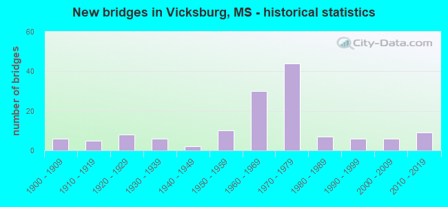
- New bridges - historical statistics
- 61900-1909
- 51910-1919
- 81920-1929
- 61930-1939
- 21940-1949
- 101950-1959
- 301960-1969
- 441970-1979
- 71980-1989
- 61990-1999
- 62000-2009
- 92010-2019

- Reconstructed bridges - Historical Statistics
- 11980-1989
- 01990-1999
- 02000-2009
- 12010-2019


- Bridge Condition - Deck
- 5.7%Very good
- 24.1%Good
- 32.2%Satisfactory
- 31.0%Fair
- 6.9%Poor

- Bridge Condition - Superstructure
- 13.0%Very good
- 41.3%Good
- 22.8%Satisfactory
- 18.5%Fair
- 4.3%Poor

- Bridge Condition - Substructure
- 10.9%Very good
- 38.0%Good
- 35.9%Satisfactory
- 14.1%Fair
- 1.1%Poor

- Bridge Condition - Channel
- 23.6%Very good
- 31.9%Good
- 30.6%Satisfactory
- 11.1%Fair
- 1.4%Poor
- 1.4%Serious

- Bridge Condition - Culverts
- 9.5%Very good
- 33.3%Good
- 47.6%Satisfactory
- 9.5%Fair
Find on map >> Show street view
Structure Number: SA7500000000048, Location: SEC 22 T16N R 3E (Lat: 32.342944, Lng: -90.879361), Route carried "on" structure: City street 9654, Year Built: 1910, Status: Posted for load, Structure Length: 3.35m (10.99ft), Average Daily Traffic: 11,500 (year 2020), Truck Traffic: 8%, Average Future Daily Traffic: 17,250 (year 2042), Design Load: HS 20, Features Intersected: KANSAS CITY SOUTHERN RR, Facility Carried by Structure: CHERRY STREET
Minimum Vertical Clearance: 30+ m (98+ ft), Kilometerpoint: 6.460, Lanes on structure: 3, Owner: City or Municipal Highway Agency, Approaching Roadway Width: 9.1m (29.9ft), Skew: 1 degrees, Material/Design: Concrete, Design/Construction: Arch - Deck, Number Of Spans In Main Unit: 1, Length of Maximum Span: 33.5m (109.9ft), Curb or Sidewalk Widths: Left: 1.8m (5.9ft), Right: 1.8m (5.9ft), Curb-To-Curb Width: 9.1m (29.9ft), Out-to-Out Width: 13.4m (44.0ft)
Condition: Deck: Fair, Superstructure: Fair, Substructure: Fair, Operating Rating: 2.7 metric tons, Method Used To Determine Operating Rating: Allowable Stress (AS), Inventory Rating: 1.6 metric tons, Method Used To Determine Inventory Rating: Allowable Stress (AS), Structural Evaluation: High priority of replacement, Deck Geometry: High priority of replacement, Underclear: Better than present minimum criteria, Approach Roadway Alignment: Equal to present minimum criteria, Bridge Posting: Required (Relationship of Operating Rating to Maximum Legal Load: > 39.9% below), Length Of Structure Improvement: 5.02m (16.47ft), Designated Inspection Frequency: Every 24 months, Inspection Date: April 2020, Bridge Improvement Cost: $724,000, Roadway Improvement Cost: $580,000, Total Project Cost: $1,304,000 ( Estimate for 2020), Deck Structure Type: Concrete Cast-file-Place, Wearing Surface/Protective System: Wearing Surface: Bituminous
Find on map >> Show street view
Structure Number: SA7500000000049, Location: SEC 22 T16N R 3E (Lat: 32.344111, Lng: -90.883722), Route carried "on" structure: City street 9659, Year Built: 1900, Status: Posted for load, Structure Length: 0.91m (2.99ft), Average Daily Traffic: 8,250 (year 2020), Truck Traffic: 8%, Average Future Daily Traffic: 11,250 (year 2042), Design Load: HS 20, Features Intersected: KANSAS CITY SOUTHERN RR, Facility Carried by Structure: WASHINGTON STREET
Minimum Vertical Clearance: 30+ m (98+ ft), Kilometerpoint: 4.100, Lanes on structure: 2, Owner: City or Municipal Highway Agency, Approaching Roadway Width: 7.9m (25.9ft), Material/Design: Masonry, Design/Construction: Arch - Deck, Number Of Spans In Main Unit: 1, Length of Maximum Span: 9.1m (29.9ft), Curb or Sidewalk Widths: Left: 2.4m (7.9ft), Right: 2.4m (7.9ft), Curb-To-Curb Width: 8.0m (26.2ft), Out-to-Out Width: 37.2m (122.0ft)
Condition: Deck: Satisfactory, Superstructure: Satisfactory, Substructure: Fair, Operating Rating: 32.4 metric tons, Method Used To Determine Operating Rating: Allowable Stress (AS), Inventory Rating: 17.1 metric tons, Method Used To Determine Inventory Rating: Allowable Stress (AS), Structural Evaluation: Meets minimum limits, Deck Geometry: High priority of replacement, Underclear: Somewhat better than minimum adequacy, Approach Roadway Alignment: Equal to present desirable criteria, Bridge Posting: Required (Relationship of Operating Rating to Maximum Legal Load: 0.1 - 9.9% below), Length Of Structure Improvement: 1.36m (4.46ft), Designated Inspection Frequency: Every 24 months, Inspection Date: April 2020, Bridge Improvement Cost: $120,000, Roadway Improvement Cost: $96,000, Total Project Cost: $216,000 ( Estimate for 2020)
Find on map >> Show street view
Structure Number: SA750000000005, Location: SEC 22 T16N R 3E (Lat: 32.342750, Lng: -90.880389), Route carried "on" structure: City street 7119, Year Built: 1965, Status: Posted for load, Structure Length: 4.82m (15.81ft), Average Daily Traffic: 6,930 (year 2020), Truck Traffic: 8%, Average Future Daily Traffic: 9,450 (year 2042), Design Load: HS 20, Features Intersected: KANSAS CITY SOUTHERN RR, Facility Carried by Structure: MONROE STREET
Minimum Vertical Clearance: 30+ m (98+ ft), Kilometerpoint: 3.040, Lanes on structure: 2, Owner: City or Municipal Highway Agency, Approaching Roadway Width: 12.2m (40.0ft), Material/Design: Steel continuous, Design/Construction: Stringer/Multi-beam, Number Of Spans In Main Unit: 3, Length of Maximum Span: 19.2m (63.0ft), Curb or Sidewalk Widths: Left: 1.5m (4.9ft), Right: 1.5m (4.9ft), Curb-To-Curb Width: 12.2m (40.0ft), Out-to-Out Width: 15.8m (51.8ft)
Condition: Deck: Satisfactory, Superstructure: Good, Substructure: Satisfactory, Operating Rating: 28.1 metric tons, Method Used To Determine Operating Rating: Load Factor (LF), Inventory Rating: 16.9 metric tons, Method Used To Determine Inventory Rating: Load Factor (LF), Structural Evaluation: Meets minimum limits, Deck Geometry: Somewhat better than minimum adequacy, Underclear: Somewhat better than minimum adequacy, Approach Roadway Alignment: Equal to present desirable criteria, Bridge Posting: Required (Relationship of Operating Rating to Maximum Legal Load: 10.0 - 19.9% below), Length Of Structure Improvement: 7.23m (23.72ft), Designated Inspection Frequency: Every 24 months, Inspection Date: April 2020, Bridge Improvement Cost: $1,230,000, Roadway Improvement Cost: $984,000, Total Project Cost: $2,214,000 ( Estimate for 2020), Deck Structure Type: Concrete Cast-file-Place
Find on map >> Show street view
Structure Number: SA7500000000051, Location: SEC 22 T16N R 3E (Lat: 32.346131, Lng: -90.874900), Route carried "on" structure: City street 6, Year Built: 1918, Status: Open, Structure Length: 1.01m (3.31ft), Average Daily Traffic: 440 (year 2021), Truck Traffic: 8%, Average Future Daily Traffic: 660 (year 2043), Features Intersected: STOUTS BAYOU, Facility Carried by Structure: HARRISON STREET
Minimum Vertical Clearance: 30+ m (98+ ft), Kilometerpoint: 0.321, Lanes on structure: 2, Owner: City or Municipal Highway Agency, Approaching Roadway Width: 13.4m (44.0ft), Material/Design: Concrete, Number Of Spans In Main Unit: 1, Length of Maximum Span: 10.1m (33.1ft), Curb or Sidewalk Widths: Left: 1.5m (4.9ft), Right: 1.5m (4.9ft), Curb-To-Curb Width: 9.8m (32.2ft), Out-to-Out Width: 13.8m (45.3ft)
Condition: Deck: Satisfactory, Superstructure: Good, Substructure: Good, Channel: Good, Operating Rating: 55.4 metric tons, Method Used To Determine Operating Rating: Load and Resistance Factor Rating (LRFR) rating reported by rating factor(RF) method using HL-93 loadings, Inventory Rating: 37.9 metric tons, Method Used To Determine Inventory Rating: Load and Resistance Factor Rating (LRFR) rating reported by rating factor(RF) method using HL-93 loadings, Structural Evaluation: Better than present minimum criteria, Deck Geometry: Equal to present minimum criteria, Waterway Adequacy: Better than present minimum criteria, Approach Roadway Alignment: Equal to present desirable criteria, Length Of Structure Improvement: 1.68m (5.51ft), Designated Inspection Frequency: Every 24 months, Inspection Date: April 2020, Bridge Improvement Cost: $250,000, Roadway Improvement Cost: $200,000, Total Project Cost: $450,000 ( Estimate for 2021), Deck Structure Type: Concrete Cast-file-Place, Wearing Surface/Protective System: Wearing Surface: Bituminous
Find on map >> Show street view
Structure Number: SA7500000000053, Location: SEC 22 T16N R 3E (Lat: 32.341667, Lng: -90.876667), Route carried "on" structure: City street , Year Built: 1936, Status: Open, Structure Length: 0.91m (2.99ft), Average Daily Traffic: 1,320 (year 2021), Truck Traffic: 8%, Average Future Daily Traffic: 1,800 (year 2043), Features Intersected: STOUTS BAYOU, Facility Carried by Structure: EAST AVE
Minimum Vertical Clearance: 30+ m (98+ ft), Kilometerpoint: 0.321, Lanes on structure: 2, Owner: City or Municipal Highway Agency, Approaching Roadway Width: 10.7m (35.1ft), Material/Design: Concrete, Design/Construction: Culvert, Number Of Spans In Main Unit: 1, Length of Maximum Span: 9.1m (29.9ft), Curb or Sidewalk Widths: Left: 1.5m (4.9ft), Right: 1.5m (4.9ft), Curb-To-Curb Width: 9.1m (29.9ft), Out-to-Out Width: 13.0m (42.7ft)
Condition: Channel: Satisfactory, Culverts: Satisfactory, Operating Rating: 32.4 metric tons, Method Used To Determine Operating Rating: Allowable Stress (AS), Inventory Rating: 17.1 metric tons, Method Used To Determine Inventory Rating: Allowable Stress (AS), Structural Evaluation: Meets minimum limits, Deck Geometry: Somewhat better than minimum adequacy, Waterway Adequacy: Equal to present minimum criteria, Approach Roadway Alignment: Equal to present minimum criteria, Length Of Structure Improvement: 0.91m (2.99ft), Designated Inspection Frequency: Every 24 months, Inspection Date: April 2020, Bridge Improvement Cost: $6,000, Roadway Improvement Cost: $130,000, Total Project Cost: $157,000 ( Estimate for 2021)
Find on map >> Show street view
Structure Number: SA7500000000054, Location: SEC 22 T16N R 3E (Lat: 32.338333, Lng: -90.875000), Route carried "on" structure: City street , Year Built: 1920, Status: Open, Structure Length: 0.82m (2.69ft), Average Daily Traffic: 1,320 (year 2021), Truck Traffic: 8%, Average Future Daily Traffic: 1,980 (year 2043), Features Intersected: STOUTS BAYOU, Facility Carried by Structure: CHAMBERS STREET
Minimum Vertical Clearance: 30+ m (98+ ft), Kilometerpoint: 0.321, Lanes on structure: 2, Owner: City or Municipal Highway Agency, Approaching Roadway Width: 11.9m (39.0ft), Material/Design: Concrete, Design/Construction: Culvert, Number Of Spans In Main Unit: 1, Length of Maximum Span: 8.2m (26.9ft), Curb or Sidewalk Widths: Left: 1.3m (4.3ft), Right: 1.3m (4.3ft), Curb-To-Curb Width: 8.2m (26.9ft), Out-to-Out Width: 12.3m (40.4ft)
Condition: Channel: Good, Culverts: Satisfactory, Operating Rating: 32.4 metric tons, Method Used To Determine Operating Rating: Allowable Stress (AS), Inventory Rating: 17.1 metric tons, Method Used To Determine Inventory Rating: Allowable Stress (AS), Structural Evaluation: Meets minimum limits, Deck Geometry: Meets minimum limits, Waterway Adequacy: Better than present minimum criteria, Approach Roadway Alignment: Equal to present minimum criteria, Length Of Structure Improvement: 1.48m (4.86ft), Designated Inspection Frequency: Every 24 months, Inspection Date: April 2020, Bridge Improvement Cost: $196,000, Roadway Improvement Cost: $157,000, Total Project Cost: $353,000 ( Estimate for 2021)
Find on map >> Show street view
Structure Number: SA7500000000056, Location: SEC 27 T16N R 3E (Lat: 32.328944, Lng: -90.876389), Route carried "on" structure: City street 667, Year Built: 1935, Status: Posted for load, Structure Length: 1.26m (4.13ft), Average Daily Traffic: 3,300 (year 2021), Truck Traffic: 8%, Average Future Daily Traffic: 4,950 (year 2043), Design Load: HS 20, Features Intersected: HALLS FERRY ROAD, Facility Carried by Structure: CONFEDERATE AVE
Minimum Vertical Clearance: 30+ m (98+ ft), Kilometerpoint: 1.931, Lanes on structure: 2, Lanes under structure: 2, Owner: City or Municipal Highway Agency, Approaching Roadway Width: 7.3m (24.0ft), Material/Design: Masonry, Design/Construction: Arch - Deck, Number Of Spans In Main Unit: 1, Length of Maximum Span: 12.6m (41.3ft), Curb or Sidewalk Widths: Left: 1.2m (3.9ft), Right: 1.2m (3.9ft), Curb-To-Curb Width: 7.3m (24.0ft), Out-to-Out Width: 9.7m (31.8ft)
Condition: Deck: Satisfactory, Superstructure: Satisfactory, Substructure: Satisfactory, Operating Rating: 73.5 metric tons, Method Used To Determine Operating Rating: Load Factor (LF), Inventory Rating: 55.9 metric tons, Method Used To Determine Inventory Rating: Load Factor (LF), Structural Evaluation: Equal to present minimum criteria, Deck Geometry: High priority of replacement, Underclear: High priority of replacement, Approach Roadway Alignment: Equal to present minimum criteria, Length Of Structure Improvement: 2.32m (7.61ft), Designated Inspection Frequency: Every 24 months, Inspection Date: November 2021, Bridge Improvement Cost: $243,000, Roadway Improvement Cost: $195,000, Total Project Cost: $438,000 ( Estimate for 2021)
Find on map >> Show street view
Structure Number: SA7500000000057, Location: SEC 28 T16N R 3E B (Lat: 32.315000, Lng: -90.863333), Route carried "on" structure: City street 8, Year Built: 1975, Status: Open, Structure Length: 0.82m (2.69ft), Average Daily Traffic: 4,950 (year 2021), Truck Traffic: 8%, Average Future Daily Traffic: 6,750 (year 2043), Design Load: HS 20, Features Intersected: DURDENS CREEK, Facility Carried by Structure: WISCONSIN AVE
Minimum Vertical Clearance: 30+ m (98+ ft), Kilometerpoint: 1.250, Lanes on structure: 2, Owner: City or Municipal Highway Agency, Approaching Roadway Width: 12.2m (40.0ft), Material/Design: Concrete, Design/Construction: Culvert, Number Of Spans In Main Unit: 1, Length of Maximum Span: 8.2m (26.9ft), Curb or Sidewalk Widths: Left: 2.4m (7.9ft), Right: 2.4m (7.9ft), Curb-To-Curb Width: 13.4m (44.0ft), Out-to-Out Width: 18.2m (59.7ft)
Condition: Channel: Satisfactory, Culverts: Very good, Operating Rating: 58.3 metric tons, Method Used To Determine Operating Rating: Load Factor (LF) rating reported by rating factor (RF) method using MS18 loading, Inventory Rating: 35.0 metric tons, Method Used To Determine Inventory Rating: Load Factor (LF) rating reported by rating factor (RF) method using MS18 loading, Structural Evaluation: Equal to present desirable criteria, Deck Geometry: Better than present minimum criteria, Waterway Adequacy: Equal to present minimum criteria, Approach Roadway Alignment: Equal to present minimum criteria, Designated Inspection Frequency: Every 24 months, Inspection Date: April 2020
Find on map >> Show street view
Structure Number: SA7500000000059, Location: SEC 29 T16N R 3E (Lat: 32.331667, Lng: -90.881667), Route carried "on" structure: City street 7119, Year Built: 1921, Status: Open, Structure Length: 0.91m (2.99ft), Average Daily Traffic: 4,490 (year 2021), Truck Traffic: 8%, Average Future Daily Traffic: 6,735 (year 2043), Features Intersected: STOUTS BAYOU, Facility Carried by Structure: DRUMMOND STREET
Minimum Vertical Clearance: 30+ m (98+ ft), Kilometerpoint: 1.850, Lanes on structure: 2, Owner: City or Municipal Highway Agency, Approaching Roadway Width: 12.8m (42.0ft), Skew: 4 degrees, Material/Design: Concrete, Design/Construction: Culvert, Number Of Spans In Main Unit: 1, Length of Maximum Span: 9.1m (29.9ft), Curb or Sidewalk Widths: Left: 1.7m (5.6ft), Right: 0.1m (0.3ft), Curb-To-Curb Width: 10.8m (35.4ft), Out-to-Out Width: 13.0m (42.7ft)
Condition: Channel: Good, Culverts: Satisfactory, Operating Rating: 32.4 metric tons, Method Used To Determine Operating Rating: Allowable Stress (AS), Inventory Rating: 17.1 metric tons, Method Used To Determine Inventory Rating: Allowable Stress (AS), Structural Evaluation: Meets minimum limits, Deck Geometry: Somewhat better than minimum adequacy, Waterway Adequacy: Equal to present minimum criteria, Approach Roadway Alignment: Equal to present minimum criteria, Length Of Structure Improvement: 1.58m (5.18ft), Designated Inspection Frequency: Every 24 months, Inspection Date: April 2020, Bridge Improvement Cost: $221,000, Roadway Improvement Cost: $177,000, Total Project Cost: $398,000 ( Estimate for 2021)
Find on map >> Show street view
Structure Number: SA750000000006, Location: SEC 29 T16N R 3E (Lat: 32.333333, Lng: -90.880000), Route carried "on" structure: City street 8, Year Built: 1937, Status: Open, Structure Length: 0.94m (3.08ft), Average Daily Traffic: 3,025 (year 2021), Truck Traffic: 8%, Average Future Daily Traffic: 4,538 (year 2043), Features Intersected: STOUTS BAYOU, Facility Carried by Structure: BOWMAR STREET
Minimum Vertical Clearance: 30+ m (98+ ft), Kilometerpoint: 6.400, Lanes on structure: 2, Owner: City or Municipal Highway Agency, Approaching Roadway Width: 12.2m (40.0ft), Material/Design: Concrete, Design/Construction: Culvert, Number Of Spans In Main Unit: 1, Length of Maximum Span: 9.4m (30.8ft), Curb or Sidewalk Widths: Left: 2.3m (7.5ft), Right: 2.3m (7.5ft), Curb-To-Curb Width: 7.9m (25.9ft), Out-to-Out Width: 12.8m (42.0ft)
Condition: Channel: Very good, Culverts: Good, Operating Rating: 32.4 metric tons, Method Used To Determine Operating Rating: Allowable Stress (AS), Inventory Rating: 17.1 metric tons, Method Used To Determine Inventory Rating: Allowable Stress (AS), Structural Evaluation: Meets minimum limits, Deck Geometry: High priority of corrective action, Waterway Adequacy: Better than present minimum criteria, Approach Roadway Alignment: Equal to present minimum criteria, Length Of Structure Improvement: 1.61m (5.28ft), Designated Inspection Frequency: Every 24 months, Inspection Date: April 2020, Bridge Improvement Cost: $222,000, Roadway Improvement Cost: $178,000, Total Project Cost: $400,000 ( Estimate for 2021)
Find on map >> Show street view
Structure Number: SA7500000000062, Location: SEC 29 T16N R 3E (Lat: 32.327778, Lng: -90.887306), Route carried "on" structure: City street 824, Year Built: 1927, Status: Posted for load, Structure Length: 1.49m (4.89ft), Average Daily Traffic: 440 (year 2021), Truck Traffic: 8%, Average Future Daily Traffic: 660 (year 2043), Design Load: HS 20, Features Intersected: STOUTS BAYOU, Facility Carried by Structure: NATIONAL STREET
Minimum Vertical Clearance: 30+ m (98+ ft), Kilometerpoint: 2.735, Lanes on structure: 2, Owner: City or Municipal Highway Agency, Approaching Roadway Width: 9.1m (29.9ft), Material/Design: Concrete, Design/Construction: Tee Beam, Number Of Spans In Main Unit: 1, Length of Maximum Span: 13.9m (45.6ft), Curb or Sidewalk Widths: Left: 1.2m (3.9ft), Right: 1.2m (3.9ft), Curb-To-Curb Width: 9.1m (29.9ft), Out-to-Out Width: 12.3m (40.4ft)
Condition: Deck: Satisfactory, Superstructure: Fair, Substructure: Fair, Channel: Satisfactory, Operating Rating: 32.6 metric tons, Method Used To Determine Operating Rating: Load Factor (LF), Inventory Rating: 19.6 metric tons, Method Used To Determine Inventory Rating: Load Factor (LF), Structural Evaluation: Somewhat better than minimum adequacy, Deck Geometry: Equal to present minimum criteria, Waterway Adequacy: Better than present minimum criteria, Approach Roadway Alignment: Equal to present desirable criteria, Bridge Posting: Required (Relationship of Operating Rating to Maximum Legal Load: 10.0 - 19.9% below), Length Of Structure Improvement: 2.17m (7.12ft), Designated Inspection Frequency: Every 24 months, Inspection Date: November 2021, Bridge Improvement Cost: $289,000, Roadway Improvement Cost: $232,000, Total Project Cost: $521,000 ( Estimate for 2021), Deck Structure Type: Concrete Cast-file-Place, Wearing Surface/Protective System: Wearing Surface: Bituminous
Find on map >> Show street view
Structure Number: SA7500000000063, Location: SEC 29 T16N R 3E (Lat: 32.326667, Lng: -90.888333), Route carried "on" structure: City street , Year Built: 1928, Status: Open, Structure Length: 1.13m (3.71ft), Average Daily Traffic: 660 (year 2021), Truck Traffic: 8%, Average Future Daily Traffic: 990 (year 2043), Features Intersected: STOUTS BAYOU, Facility Carried by Structure: POLK STREET
Minimum Vertical Clearance: 30+ m (98+ ft), Kilometerpoint: 0.160, Lanes on structure: 2, Owner: City or Municipal Highway Agency, Approaching Roadway Width: 11.6m (38.1ft), Material/Design: Concrete, Design/Construction: Culvert, Number Of Spans In Main Unit: 1, Length of Maximum Span: 11.3m (37.1ft), Curb or Sidewalk Widths: Left: 1.3m (4.3ft), Right: 1.3m (4.3ft), Curb-To-Curb Width: 8.5m (27.9ft), Out-to-Out Width: 11.6m (38.1ft)
Condition: Channel: Satisfactory, Culverts: Good, Operating Rating: 32.4 metric tons, Method Used To Determine Operating Rating: Allowable Stress (AS), Inventory Rating: 17.1 metric tons, Method Used To Determine Inventory Rating: Allowable Stress (AS), Structural Evaluation: Meets minimum limits, Deck Geometry: Somewhat better than minimum adequacy, Waterway Adequacy: Better than present minimum criteria, Approach Roadway Alignment: Equal to present minimum criteria, Length Of Structure Improvement: 1.80m (5.91ft), Designated Inspection Frequency: Every 24 months, Inspection Date: April 2020, Bridge Improvement Cost: $226,000, Roadway Improvement Cost: $181,000, Total Project Cost: $407,000 ( Estimate for 2021)
Find on map >> Show street view
Structure Number: SA7500000000064, Location: SEC 29 T16N R 3E (Lat: 32.324806, Lng: -90.889500), Route carried "on" structure: City street 7119, Year Built: 1964, Status: Posted for load, Structure Length: 2.36m (7.74ft), Average Daily Traffic: 990 (year 2021), Truck Traffic: 8%, Average Future Daily Traffic: 1,485 (year 2043), Design Load: HS 20, Features Intersected: STOUTS BAYOU, Facility Carried by Structure: LEE STREET
Minimum Vertical Clearance: 30+ m (98+ ft), Kilometerpoint: 0.240, Lanes on structure: 2, Owner: City or Municipal Highway Agency, Approaching Roadway Width: 12.2m (40.0ft), Skew: 3 degrees, Material/Design: Steel, Design/Construction: Stringer/Multi-beam, Number Of Spans In Main Unit: 1, Length of Maximum Span: 22.9m (75.1ft), Curb or Sidewalk Widths: Left: 1.5m (4.9ft), Right: 1.5m (4.9ft), Curb-To-Curb Width: 12.2m (40.0ft), Out-to-Out Width: 15.3m (50.2ft)
Condition: Deck: Satisfactory, Superstructure: Good, Substructure: Satisfactory, Channel: Satisfactory, Operating Rating: 15.4 metric tons, Method Used To Determine Operating Rating: Load Factor (LF), Inventory Rating: 9.2 metric tons, Method Used To Determine Inventory Rating: Load Factor (LF), Structural Evaluation: High priority of replacement, Deck Geometry: Equal to present desirable criteria, Waterway Adequacy: Better than present minimum criteria, Approach Roadway Alignment: Equal to present minimum criteria, Bridge Posting: Required (Relationship of Operating Rating to Maximum Legal Load: > 39.9% below), Length Of Structure Improvement: 3.54m (11.61ft), Designated Inspection Frequency: Every 24 months, Inspection Date: January 2021, Bridge Improvement Cost: $583,000, Roadway Improvement Cost: $467,000, Total Project Cost: $1,050,000 ( Estimate for 2021), Deck Structure Type: Concrete Cast-file-Place
Find on map >> Show street view
Structure Number: SA7500000000065, Location: SEC 30 T16N R 3E (Lat: 32.317250, Lng: -90.893972), Route carried "on" structure: City street 451, Year Built: 1934, Status: Posted for load, Structure Length: 14.17m (46.49ft), Average Daily Traffic: 1,540 (year 2020), Truck Traffic: 8%, Average Future Daily Traffic: 2,310 (year 2042), Design Load: HS 20, Features Intersected: KCS RR AND STOUTS BAYOU, Facility Carried by Structure: OLD HWY 80
Minimum Vertical Clearance: 30+ m (98+ ft), Kilometerpoint: 0.321, Lanes on structure: 2, Owner: City or Municipal Highway Agency, Approaching Roadway Width: 6.7m (22.0ft), Material/Design: Steel continuous, Design/Construction: Stringer/Multi-beam, Number Of Spans In Main Unit: 8, Length of Maximum Span: 17.7m (58.1ft), Curb or Sidewalk Widths: Left: 1.0m (3.3ft), Right: 1.0m (3.3ft), Curb-To-Curb Width: 6.7m (22.0ft), Out-to-Out Width: 9.2m (30.2ft)
Condition: Deck: Satisfactory, Superstructure: Satisfactory, Substructure: Satisfactory, Channel: Very good, Operating Rating: 29.5 metric tons, Method Used To Determine Operating Rating: Load Factor (LF), Inventory Rating: 17.7 metric tons, Method Used To Determine Inventory Rating: Load Factor (LF), Structural Evaluation: Meets minimum limits, Deck Geometry: High priority of corrective action, Underclear: Somewhat better than minimum adequacy, Waterway Adequacy: Superior to present desirable criteria, Approach Roadway Alignment: Meets minimum limits, Bridge Posting: Required (Relationship of Operating Rating to Maximum Legal Load: 10.0 - 19.9% below), Length Of Structure Improvement: 21.25m (69.72ft), Designated Inspection Frequency: Every 24 months, Critical Feature Inspection Frequency: Every 24 months, Inspection Date: April 2020, Critical Feature Inspection Date: April 2020, Bridge Improvement Cost: $2,104,000, Roadway Improvement Cost: $1,684,000, Total Project Cost: $3,788,000 ( Estimate for 2020), Deck Structure Type: Concrete Cast-file-Place
Find on map >> Show street view
Structure Number: SA7500000000068, Location: SEC 19 T16N R 4E (Lat: 32.362056, Lng: -90.862056), Route carried "on" structure: City street , Year Built: 1989, Year Reconstructed: 2021, Status: Open, Structure Length: 1.89m (6.20ft), Average Daily Traffic: 110 (year 2020), Truck Traffic: 8%, Average Future Daily Traffic: 150 (year 2042), Design Load: H 15, Features Intersected: GLASS BAYOU, Facility Carried by Structure: ZOLLINGER ST
Minimum Vertical Clearance: 30+ m (98+ ft), Kilometerpoint: 0.321, Lanes on structure: 2, Owner: City or Municipal Highway Agency, Approaching Roadway Width: 7.0m (23.0ft), Material/Design: Concrete, Design/Construction: Channel Beam, Number Of Spans In Main Unit: 2, Length of Maximum Span: 9.4m (30.8ft), Curb or Sidewalk Widths: Left: 0.2m (0.7ft), Right: 0.2m (0.7ft), Curb-To-Curb Width: 7.1m (23.3ft), Out-to-Out Width: 7.5m (24.6ft)
Condition: Deck: Good, Superstructure: Good, Substructure: Good, Channel: Good, Operating Rating: 55.2 metric tons, Method Used To Determine Operating Rating: Load Factor (LF), Inventory Rating: 33.0 metric tons, Method Used To Determine Inventory Rating: Load Factor (LF), Structural Evaluation: Better than present minimum criteria, Deck Geometry: Meets minimum limits, Waterway Adequacy: Better than present minimum criteria, Approach Roadway Alignment: Better than present minimum criteria, Length Of Structure Improvement: 2.62m (8.60ft), Designated Inspection Frequency: Every 24 months, Inspection Date: March 2021, Bridge Improvement Cost: $232,000, Roadway Improvement Cost: $186,000, Total Project Cost: $418,000 ( Estimate for 2021), Deck Structure Type: Concrete Precast Panels
Find on map >> Show street view
Structure Number: SA7500000000069, Location: SEC 21 T16N R 4E (Lat: 32.343614, Lng: -90.853194), Route carried "on" structure: City street 9, Year Built: 1972, Status: Open, Structure Length: 2.74m (8.99ft), Average Daily Traffic: 18,750 (year 2021), Truck Traffic: 8%, Average Future Daily Traffic: 25,500 (year 2043), Design Load: HS 20, Features Intersected: PARK ROAD, Facility Carried by Structure: CLAY STREET
Minimum Vertical Clearance: 30+ m (98+ ft), Kilometerpoint: 3.220, Lanes on structure: 4, Lanes under structure: 2, Owner: Town or Township Highway Agency, Approaching Roadway Width: 24.4m (80.1ft), Material/Design: Prestressed concrete, Design/Construction: Stringer/Multi-beam, Number Of Spans In Main Unit: 1, Length of Maximum Span: 27.4m (89.9ft), Curb or Sidewalk Widths: Left: 1.7m (5.6ft), Right: 1.7m (5.6ft), Curb-To-Curb Width: 19.8m (65.0ft), Out-to-Out Width: 23.8m (78.1ft)
Condition: Deck: Satisfactory, Superstructure: Satisfactory, Substructure: Satisfactory, Operating Rating: 37.8 metric tons, Method Used To Determine Operating Rating: Allowable Stress (AS), Inventory Rating: 32.4 metric tons, Method Used To Determine Inventory Rating: Allowable Stress (AS), Structural Evaluation: Equal to present minimum criteria, Deck Geometry: Better than present minimum criteria, Underclear: Superior to present desirable criteria, Approach Roadway Alignment: Equal to present desirable criteria, Designated Inspection Frequency: Every 24 months, Inspection Date: April 2020, Deck Structure Type: Concrete Cast-file-Place, Wearing Surface/Protective System: Wearing Surface: Monolithic Concrete
Find on map >> Show street view
Structure Number: SA750000000007, Location: SEC 21 T16N R 4E (Lat: 32.340722, Lng: -90.849278), Route carried "on" structure: City street , Year Built: 1928, Status: Open, Structure Length: 3.31m (10.86ft), Average Daily Traffic: 5,500 (year 2020), Truck Traffic: 8%, Average Future Daily Traffic: 7,500 (year 2042), Design Load: H 15, Features Intersected: KANSAS CITY SOUTHERN RR, Facility Carried by Structure: OLD HWY 27
Minimum Vertical Clearance: 30+ m (98+ ft), Kilometerpoint: 5.793, Lanes on structure: 2, Owner: City or Municipal Highway Agency, Approaching Roadway Width: 7.9m (25.9ft), Skew: 4 degrees, Material/Design: Concrete, Design/Construction: Slab, Number Of Spans In Main Unit: 4, Length of Maximum Span: 8.7m (28.5ft), Curb or Sidewalk Widths: Left: 0.2m (0.7ft), Right: 1.2m (3.9ft), Curb-To-Curb Width: 8.0m (26.2ft), Out-to-Out Width: 10.0m (32.8ft)
Condition: Deck: Fair, Superstructure: Fair, Substructure: Satisfactory, Operating Rating: 54.6 metric tons, Method Used To Determine Operating Rating: Load Factor (LF), Inventory Rating: 32.7 metric tons, Method Used To Determine Inventory Rating: Load Factor (LF), Structural Evaluation: Somewhat better than minimum adequacy, Deck Geometry: High priority of replacement, Underclear: Meets minimum limits, Approach Roadway Alignment: Equal to present minimum criteria, Length Of Structure Improvement: 4.96m (16.27ft), Designated Inspection Frequency: Every 24 months, Inspection Date: April 2020, Bridge Improvement Cost: $534,000, Roadway Improvement Cost: $428,000, Total Project Cost: $962,000 ( Estimate for 2020), Deck Structure Type: Concrete Cast-file-Place
Find on map >> Show street view
Structure Number: SA7500000000074, Location: SEC 32 T16N R 4E B (Lat: 32.334417, Lng: -90.844528), Route carried "on" structure: County highway , Year Built: 1928, Status: Posted for load, Structure Length: 0.91m (2.99ft), Average Daily Traffic: 1,071 (year 2021), Truck Traffic: 8%, Average Future Daily Traffic: 1,606 (year 2043), Design Load: HS 20, Features Intersected: LOCAL CREEK, Facility Carried by Structure: OLD HWY 27
Minimum Vertical Clearance: 30+ m (98+ ft), Kilometerpoint: 4.988, Lanes on structure: 2, Owner: City or Municipal Highway Agency, Approaching Roadway Width: 6.2m (20.3ft), Material/Design: Steel, Design/Construction: Stringer/Multi-beam, Number Of Spans In Main Unit: 1, Length of Maximum Span: 8.7m (28.5ft), Curb or Sidewalk Widths: Left: 0.3m (1.0ft), Right: 0.3m (1.0ft), Curb-To-Curb Width: 6.6m (21.7ft), Out-to-Out Width: 7.2m (23.6ft)
Condition: Deck: Fair, Superstructure: Fair, Substructure: Fair, Channel: Satisfactory, Operating Rating: 31.5 metric tons, Method Used To Determine Operating Rating: Load Factor (LF), Inventory Rating: 18.9 metric tons, Method Used To Determine Inventory Rating: Load Factor (LF), Structural Evaluation: Somewhat better than minimum adequacy, Deck Geometry: High priority of replacement, Waterway Adequacy: Better than present minimum criteria, Approach Roadway Alignment: Meets minimum limits, Bridge Posting: Required (Relationship of Operating Rating to Maximum Legal Load: 20.0 - 29.9% below), Length Of Structure Improvement: 1.36m (4.46ft), Designated Inspection Frequency: Every 12 months, Inspection Date: January 2021, Bridge Improvement Cost: $106,000, Roadway Improvement Cost: $85,000, Total Project Cost: $191,000 ( Estimate for 2021), Deck Structure Type: Concrete Cast-file-Place, Wearing Surface/Protective System: Wearing Surface: Bituminous
Find on map >> Show street view
Structure Number: SA7500000000077, Location: SEC 40 T16N R 4E B (Lat: 32.396667, Lng: -90.853333), Route carried "on" structure: County highway , Year Built: 1964, Status: Open, Structure Length: 1.40m (4.59ft), Average Daily Traffic: 220 (year 2021), Truck Traffic: 8%, Average Future Daily Traffic: 320 (year 2043), Design Load: HS 20+Mod, Features Intersected: LOCAL CREEK, Facility Carried by Structure: SPOUTS SPRING ROAD
Minimum Vertical Clearance: 30+ m (98+ ft), Kilometerpoint: 0.160, Lanes on structure: 2, Owner: City or Municipal Highway Agency, Approaching Roadway Width: 7.3m (24.0ft), Material/Design: Concrete, Design/Construction: Channel Beam, Number Of Spans In Main Unit: 2, Length of Maximum Span: 9.4m (30.8ft), Curb or Sidewalk Widths: Left: 0.2m (0.7ft), Right: 0.2m (0.7ft), Curb-To-Curb Width: 7.0m (23.0ft), Out-to-Out Width: 7.5m (24.6ft)
Condition: Deck: Good, Superstructure: Satisfactory, Substructure: Very good, Channel: Very good, Operating Rating: 49.2 metric tons, Method Used To Determine Operating Rating: Allowable Stress (AS), Inventory Rating: 38.2 metric tons, Method Used To Determine Inventory Rating: Allowable Stress (AS), Structural Evaluation: Equal to present minimum criteria, Deck Geometry: Meets minimum limits, Waterway Adequacy: Better than present minimum criteria, Approach Roadway Alignment: Equal to present desirable criteria, Length Of Structure Improvement: 0.20m (0.66ft), Designated Inspection Frequency: Every 24 months, Inspection Date: April 2020, Bridge Improvement Cost: $23,000, Roadway Improvement Cost: $130,000, Total Project Cost: $177,000, Deck Structure Type: Concrete Precast Panels, Wearing Surface/Protective System: Wearing Surface: Monolithic Concrete
Find on map >> Show street view
Structure Number: SA7500000000088, Location: SEC 9 T17N R 4E B (Lat: 32.468964, Lng: -90.785750), Route carried "on" structure: County highway 1, Year Built: 1954, Status: Open, Structure Length: 0.67m (2.20ft), Average Daily Traffic: 495 (year 2021), Truck Traffic: 8%, Average Future Daily Traffic: 675 (year 2043), Design Load: HS 20+Mod, Features Intersected: SKILLIKALIA BAYOU, Facility Carried by Structure: REDWOOD ROAD
Minimum Vertical Clearance: 30+ m (98+ ft), Kilometerpoint: 2.574, Lanes on structure: 2, Owner: County Highway Agency, Approaching Roadway Width: 7.9m (25.9ft), Material/Design: Concrete, Design/Construction: Culvert, Number Of Spans In Main Unit: 1, Length of Maximum Span: 6.7m (22.0ft)
Condition: Channel: Good, Culverts: Good, Operating Rating: 54.1 metric tons, Method Used To Determine Operating Rating: Load Factor (LF) rating reported by rating factor (RF) method using MS18 loading, Inventory Rating: 32.4 metric tons, Method Used To Determine Inventory Rating: Load Factor (LF) rating reported by rating factor (RF) method using MS18 loading, Structural Evaluation: Better than present minimum criteria, Waterway Adequacy: Equal to present minimum criteria, Approach Roadway Alignment: Equal to present desirable criteria, Length Of Structure Improvement: 0.10m (0.33ft), Designated Inspection Frequency: Every 24 months, Inspection Date: April 2020, Bridge Improvement Cost: $2,000, Roadway Improvement Cost: $1,000, Total Project Cost: $3,000
Find on map >> Show street view
Structure Number: SA750000000009, Location: SEC 24 T17N R 4E B (Lat: 32.413333, Lng: -90.775000), Route carried "on" structure: County highway , Year Built: 1993, Status: Open, Structure Length: 3.05m (10.01ft), Average Daily Traffic: 1,123 (year 2021), Truck Traffic: 8%, Average Future Daily Traffic: 1,516 (year 2043), Design Load: HS 20+Mod, Features Intersected: LOCAL LAKE, Facility Carried by Structure: TUCKER ROAD
Minimum Vertical Clearance: 30+ m (98+ ft), Kilometerpoint: 0.804, Lanes on structure: 2, Owner: County Highway Agency, Approaching Roadway Width: 9.1m (29.9ft), Material/Design: Concrete, Design/Construction: Channel Beam, Number Of Spans In Main Unit: 4, Length of Maximum Span: 9.4m (30.8ft), Curb-To-Curb Width: 8.5m (27.9ft), Out-to-Out Width: 9.3m (30.5ft)
Condition: Deck: Good, Superstructure: Good, Substructure: Good, Channel: Good, Operating Rating: 32.4 metric tons, Method Used To Determine Operating Rating: Allowable Stress (AS), Inventory Rating: 24.0 metric tons, Method Used To Determine Inventory Rating: Allowable Stress (AS), Structural Evaluation: Equal to present minimum criteria, Deck Geometry: Somewhat better than minimum adequacy, Waterway Adequacy: Superior to present desirable criteria, Approach Roadway Alignment: Equal to present minimum criteria, Designated Inspection Frequency: Every 24 months, Inspection Date: April 2020, Deck Structure Type: Concrete Cast-file-Place, Wearing Surface/Protective System: Wearing Surface: Monolithic Concrete
Find on map >> Show street view
Structure Number: SA7500000000102, Location: SEC 17 T15N R 3E (Lat: 32.280556, Lng: -90.916667), Route carried "on" structure: Alternate County highway , Year Built: 2000, Status: Open, Structure Length: 4.90m (16.08ft), Average Daily Traffic: 10,000 (year 2020), Truck Traffic: 3%, Average Future Daily Traffic: 10,000 (year 2042), Design Load: HS 20, Features Intersected: KCS RAILROAD, Facility Carried by Structure: COUNTY ROAD
Minimum Vertical Clearance: 30+ m (98+ ft), Kilometerpoint: 0.405, Lanes on structure: 2, Owner: County Highway Agency, Approaching Roadway Width: 15.8m (51.8ft), Skew: 4 degrees, Material/Design: Concrete continuous, Design/Construction: Stringer/Multi-beam, Number Of Spans In Main Unit: 3, Length of Maximum Span: 31.4m (103.0ft), Curb-To-Curb Width: 15.8m (51.8ft), Out-to-Out Width: 16.7m (54.8ft)
Condition: Deck: Good, Superstructure: Good, Substructure: Good, Operating Rating: 40.0 metric tons, Method Used To Determine Operating Rating: Allowable Stress (AS), Inventory Rating: 32.4 metric tons, Method Used To Determine Inventory Rating: Allowable Stress (AS), Structural Evaluation: Better than present minimum criteria, Deck Geometry: Superior to present desirable criteria, Underclear: Superior to present desirable criteria, Approach Roadway Alignment: Equal to present desirable criteria, Designated Inspection Frequency: Every 24 months, Inspection Date: May 2020, Deck Structure Type: Concrete Cast-file-Place, Wearing Surface/Protective System: Wearing Surface: Monolithic Concrete
Find on map >> Show street view
Structure Number: SA7500000000103, Location: SEC 17 T15N R 3E (Lat: 32.281389, Lng: -90.917222), Route carried "on" structure: Alternate City street , Year Built: 2000, Status: Open, Structure Length: 10.43m (34.22ft), Average Daily Traffic: 4,500 (year 2020), Truck Traffic: 3%, Average Future Daily Traffic: 6,000 (year 2042), Design Load: HS 20, Features Intersected: HENNESSEYS BAYOU, Facility Carried by Structure: SR 161
Minimum Vertical Clearance: 30+ m (98+ ft), Kilometerpoint: 0.523, Lanes on structure: 2, Owner: City or Municipal Highway Agency, Approaching Roadway Width: 15.8m (51.8ft), Material/Design: Concrete continuous, Design/Construction: Stringer/Multi-beam, Number Of Spans In Main Unit: 1, Number Of Approach Spans: 4, Length of Maximum Span: 30.5m (100.1ft), Curb-To-Curb Width: 15.8m (51.8ft), Out-to-Out Width: 16.7m (54.8ft)
Condition: Deck: Good, Superstructure: Good, Substructure: Good, Channel: Satisfactory, Operating Rating: 43.2 metric tons, Method Used To Determine Operating Rating: Allowable Stress (AS), Inventory Rating: 32.4 metric tons, Method Used To Determine Inventory Rating: Allowable Stress (AS), Structural Evaluation: Better than present minimum criteria, Deck Geometry: Superior to present desirable criteria, Waterway Adequacy: Equal to present desirable criteria, Approach Roadway Alignment: Equal to present minimum criteria, Designated Inspection Frequency: Every 24 months, Inspection Date: May 2020, Deck Structure Type: Concrete Cast-file-Place, Wearing Surface/Protective System: Wearing Surface: Monolithic Concrete
Find on map >> Show street view
Structure Number: SA7500000000104, Location: SEC 8 T15N R 3E (Lat: 32.282222, Lng: -90.917778), Route carried "on" structure: Alternate City street , Year Built: 2000, Status: Open, Structure Length: 7.38m (24.21ft), Average Daily Traffic: 4,000 (year 2020), Truck Traffic: 3%, Average Future Daily Traffic: 6,000 (year 2042), Design Load: HS 20, Features Intersected: HENNESSEYS BAYOU RELIEF, Facility Carried by Structure: SR 161
Minimum Vertical Clearance: 30+ m (98+ ft), Kilometerpoint: 0.624, Lanes on structure: 2, Owner: City or Municipal Highway Agency, Approaching Roadway Width: 15.8m (51.8ft), Material/Design: Concrete continuous, Design/Construction: Stringer/Multi-beam, Number Of Spans In Main Unit: 6, Length of Maximum Span: 12.2m (40.0ft), Curb-To-Curb Width: 15.8m (51.8ft), Out-to-Out Width: 15.8m (51.8ft)
Condition: Deck: Good, Superstructure: Very good, Substructure: Good, Channel: Very good, Operating Rating: 43.2 metric tons, Method Used To Determine Operating Rating: Allowable Stress (AS), Inventory Rating: 32.4 metric tons, Method Used To Determine Inventory Rating: Allowable Stress (AS), Structural Evaluation: Better than present minimum criteria, Deck Geometry: Superior to present desirable criteria, Waterway Adequacy: Equal to present desirable criteria, Approach Roadway Alignment: Equal to present minimum criteria, Designated Inspection Frequency: Every 24 months, Inspection Date: May 2020, Deck Structure Type: Concrete Cast-file-Place, Wearing Surface/Protective System: Wearing Surface: Monolithic Concrete
Find on map >> Show street view
Structure Number: SA7500000000106, Location: SEC 1 T15N R 3E (Lat: 32.309778, Lng: -90.865861), Route carried "on" structure: City street 128, Year Built: 2012, Status: Open, Structure Length: 2.90m (9.51ft), Average Daily Traffic: 1,400 (year 2021), Truck Traffic: 6%, Average Future Daily Traffic: 2,100 (year 2043), Design Load: HL 93, Features Intersected: DURDEN CREEK, Facility Carried by Structure: BAZINSKY ROAD
Minimum Vertical Clearance: 30+ m (98+ ft), Kilometerpoint: 1.287, Lanes on structure: 2, Owner: City or Municipal Highway Agency, Approaching Roadway Width: 6.2m (20.3ft), Skew: 3 degrees, Material/Design: Concrete, Design/Construction: Channel Beam, Number Of Spans In Main Unit: 3, Length of Maximum Span: 9.4m (30.8ft), Curb-To-Curb Width: 8.6m (28.2ft), Out-to-Out Width: 9.4m (30.8ft)
Condition: Deck: Very good, Superstructure: Good, Substructure: Good, Channel: Good, Operating Rating: 43.7 metric tons, Method Used To Determine Operating Rating: Load and Resistance Factor Rating (LRFR) rating reported by rating factor(RF) method using HL-93 loadings, Inventory Rating: 33.7 metric tons, Method Used To Determine Inventory Rating: Load and Resistance Factor Rating (LRFR) rating reported by rating factor(RF) method using HL-93 loadings, Structural Evaluation: Better than present minimum criteria, Deck Geometry: Somewhat better than minimum adequacy, Waterway Adequacy: Equal to present desirable criteria, Approach Roadway Alignment: Better than present minimum criteria, Length Of Structure Improvement: 3.81m (12.50ft), Designated Inspection Frequency: Every 24 months, Inspection Date: March 2021, Bridge Improvement Cost: $385,000, Roadway Improvement Cost: $308,000, Total Project Cost: $693,000 ( Estimate for 2021), Deck Structure Type: Concrete Precast Panels
Find on map >> Show street view
Structure Number: SA7500000000107, Location: SEC_38_T15N_R 3E B (Lat: 32.224944, Lng: -90.912917), Route carried "on" structure: County highway 17, Year Built: 2012, Status: Open, Structure Length: 3.72m (12.20ft), Average Daily Traffic: 1,668 (year 2021), Truck Traffic: 10%, Average Future Daily Traffic: 2,502 (year 2043), Design Load: HS 20, Features Intersected: PACES BAYOU, Facility Carried by Structure: REDBONE ROAD
Minimum Vertical Clearance: 30+ m (98+ ft), Kilometerpoint: 13.357, Lanes on structure: 2, Owner: County Highway Agency, Approaching Roadway Width: 7.2m (23.6ft), Material/Design: Prestressed concrete, Design/Construction: Stringer/Multi-beam, Number Of Spans In Main Unit: 3, Length of Maximum Span: 18.3m (60.0ft), Curb-To-Curb Width: 8.5m (27.9ft), Out-to-Out Width: 9.4m (30.8ft)
Condition: Deck: Good, Superstructure: Very good, Substructure: Good, Channel: Good, Operating Rating: 64.7 metric tons, Method Used To Determine Operating Rating: Load Factor (LF), Inventory Rating: 38.9 metric tons, Method Used To Determine Inventory Rating: Load Factor (LF), Structural Evaluation: Better than present minimum criteria, Deck Geometry: Somewhat better than minimum adequacy, Waterway Adequacy: Superior to present desirable criteria, Approach Roadway Alignment: Equal to present desirable criteria, Length Of Structure Improvement: 4.65m (15.26ft), Designated Inspection Frequency: Every 24 months, Inspection Date: March 2021, Bridge Improvement Cost: $470,000, Roadway Improvement Cost: $376,000, Total Project Cost: $846,000 ( Estimate for 2021), Deck Structure Type: Concrete Cast-file-Place
Find on map >> Show street view
Structure Number: SA750000000011, Location: SEC 12 T16N R 3E B (Lat: 32.380361, Lng: -90.869028), Route carried "on" structure: City street 126, Year Built: 2011, Status: Open, Structure Length: 11.56m (37.93ft), Average Daily Traffic: 3,144 (year 2020), Truck Traffic: 8%, Average Future Daily Traffic: 4,087 (year 2042), Design Load: HS 20, Features Intersected: MIDSOUTH RR / LOCAL ROAD, Facility Carried by Structure: HAINING ROAD
Minimum Vertical Clearance: 30+ m (98+ ft), Kilometerpoint: 0.000, Lanes on structure: 3, Lanes under structure: 2, Owner: City or Municipal Highway Agency, Approaching Roadway Width: 18.3m (60.0ft), Skew: 1 degrees, Material/Design: Prestressed concrete, Design/Construction: Stringer/Multi-beam, Number Of Spans In Main Unit: 6, Length of Maximum Span: 25.0m (82.0ft), Curb-To-Curb Width: 18.3m (60.0ft), Out-to-Out Width: 19.2m (63.0ft)
Condition: Deck: Good, Superstructure: Very good, Substructure: Very good, Operating Rating: 70.1 metric tons, Method Used To Determine Operating Rating: Load Factor (LF), Inventory Rating: 37.5 metric tons, Method Used To Determine Inventory Rating: Load Factor (LF), Structural Evaluation: Equal to present desirable criteria, Deck Geometry: Superior to present desirable criteria, Underclear: Superior to present desirable criteria, Approach Roadway Alignment: Equal to present minimum criteria, Length Of Structure Improvement: 17.34m (56.89ft), Designated Inspection Frequency: Every 24 months, Inspection Date: December 2020, Bridge Improvement Cost: $4,000,000, Roadway Improvement Cost: $3,200,000, Total Project Cost: $7,200,000 ( Estimate for 2020), Deck Structure Type: Concrete Cast-file-Place
Find on map >> Show street view
Structure Number: SA7500000000111, Location: SEC 28 T17N R 4E (Lat: 32.425625, Lng: -90.824722), Route carried "on" structure: City street , Year Built: 1936, Status: Posted for load, Structure Length: 2.59m (8.50ft), Average Daily Traffic: 20 (year 2021), Truck Traffic: 8%, Average Future Daily Traffic: 30 (year 2043), Design Load: HS 15, Features Intersected: N WASHINGTON ST, Facility Carried by Structure: BLISS CREEK
Minimum Vertical Clearance: 30+ m (98+ ft), Kilometerpoint: 0.000, Lanes on structure: 2, Owner: City or Municipal Highway Agency, Approaching Roadway Width: 7.3m (24.0ft), Skew: 2 degrees, Material/Design: Steel, Design/Construction: Stringer/Multi-beam, Number Of Spans In Main Unit: 100, Number Of Approach Spans: 2, Length of Maximum Span: 13.7m (44.9ft), Curb-To-Curb Width: 7.3m (24.0ft), Out-to-Out Width: 8.4m (27.6ft)
Condition: Deck: Satisfactory, Superstructure: Satisfactory, Substructure: Fair, Channel: Satisfactory, Operating Rating: 30.5 metric tons, Method Used To Determine Operating Rating: Load Factor (LF), Inventory Rating: 18.3 metric tons, Method Used To Determine Inventory Rating: Load Factor (LF), Structural Evaluation: Somewhat better than minimum adequacy, Deck Geometry: Equal to present minimum criteria, Waterway Adequacy: Better than present minimum criteria, Approach Roadway Alignment: Equal to present minimum criteria, Bridge Posting: Required (Relationship of Operating Rating to Maximum Legal Load: 10.0 - 19.9% below), Length Of Structure Improvement: 3.89m (12.76ft), Designated Inspection Frequency: Every 24 months, Inspection Date: June 2020, Bridge Improvement Cost: $351,000, Roadway Improvement Cost: $281,000, Total Project Cost: $632,000 ( Estimate for 2021), Deck Structure Type: Concrete Cast-file-Place
Find on map >> Show street view
Structure Number: SA7500000000112, Location: SEC 21 T16N R 4E (Lat: 32.343111, Lng: -90.857000), Route carried "on" structure: City street 405, Year Built: 1971, Status: Posted for load, Structure Length: 4.01m (13.16ft), Average Daily Traffic: 50 (year 2020), Truck Traffic: 8%, Average Future Daily Traffic: 2 (year 2042), Design Load: H 15, Features Intersected: KANSAS CITY SOUTHERN RR, Facility Carried by Structure: MELBORN PLACE
Minimum Vertical Clearance: 30+ m (98+ ft), Kilometerpoint: 0.020, Lanes on structure: 2, Owner: City or Municipal Highway Agency, Approaching Roadway Width: 6.4m (21.0ft), Material/Design: Concrete continuous, Design/Construction: Slab, Number Of Spans In Main Unit: 3, Length of Maximum Span: 15.2m (49.9ft), Curb or Sidewalk Widths: Left: 0.3m (1.0ft), Right: 0.3m (1.0ft), Curb-To-Curb Width: 7.9m (25.9ft), Out-to-Out Width: 9.3m (30.5ft)
Condition: Deck: Satisfactory, Superstructure: Satisfactory, Substructure: Fair, Operating Rating: 29.9 metric tons, Method Used To Determine Operating Rating: Load Factor (LF), Inventory Rating: 11.1 metric tons, Method Used To Determine Inventory Rating: Load Factor (LF), Structural Evaluation: Meets minimum limits, Deck Geometry: Equal to present minimum criteria, Underclear: Superior to present desirable criteria, Approach Roadway Alignment: Somewhat better than minimum adequacy, Bridge Posting: Required (Relationship of Operating Rating to Maximum Legal Load: 0.1 - 9.9% below), Length Of Structure Improvement: 6.02m (19.75ft), Designated Inspection Frequency: Every 24 months, Inspection Date: April 2020, Bridge Improvement Cost: $400,000, Roadway Improvement Cost: $320,000, Total Project Cost: $720,000 ( Estimate for 2019), Deck Structure Type: Concrete Cast-file-Place, Wearing Surface/Protective System: Wearing Surface: Bituminous
Find on map >> Show street view
Structure Number: SA750000000A019, Location: SEC 11 T15N R 3E (Lat: 32.289083, Lng: -90.896722), Route carried "on" structure: City street 184, Year Built: 2014, Status: Open, Structure Length: 2.15m (7.05ft), Average Daily Traffic: 795 (year 2021), Truck Traffic: 8%, Average Future Daily Traffic: 1,000 (year 2043), Design Load: HL 93, Features Intersected: LOCAL CREEK, Facility Carried by Structure: CAIRO STREET
Minimum Vertical Clearance: 30+ m (98+ ft), Kilometerpoint: 22.530, Lanes on structure: 2, Owner: City or Municipal Highway Agency, Approaching Roadway Width: 6.4m (21.0ft), Material/Design: Concrete, Design/Construction: Channel Beam, Number Of Spans In Main Unit: 3, Length of Maximum Span: 9.4m (30.8ft), Curb or Sidewalk Widths: Left: 0.2m (0.7ft), Right: 0.2m (0.7ft), Curb-To-Curb Width: 8.2m (26.9ft), Out-to-Out Width: 8.6m (28.2ft)
Condition: Deck: Very good, Superstructure: Good, Substructure: Good, Channel: Very good, Operating Rating: 43.7 metric tons, Method Used To Determine Operating Rating: Load and Resistance Factor Rating (LRFR) rating reported by rating factor(RF) method using HL-93 loadings, Inventory Rating: 33.7 metric tons, Method Used To Determine Inventory Rating: Load and Resistance Factor Rating (LRFR) rating reported by rating factor(RF) method using HL-93 loadings, Structural Evaluation: Better than present minimum criteria, Deck Geometry: Somewhat better than minimum adequacy, Waterway Adequacy: Equal to present desirable criteria, Approach Roadway Alignment: Better than present minimum criteria, Length Of Structure Improvement: 2.94m (9.65ft), Designated Inspection Frequency: Every 24 months, Inspection Date: March 2021, Bridge Improvement Cost: $273,000, Roadway Improvement Cost: $219,000, Total Project Cost: $492,000 ( Estimate for 2021), Deck Structure Type: Concrete Precast Panels
Find on map >> Show street view
Structure Number: SA750000000A052, Location: SEC 22 T16N R 3E (Lat: 32.343056, Lng: -90.875833), Route carried "on" structure: City street 645, Year Built: 2015, Status: Open, Structure Length: 2.10m (6.89ft), Average Daily Traffic: 525 (year 2021), Truck Traffic: 8%, Average Future Daily Traffic: 788 (year 2043), Design Load: HL 93, Features Intersected: STOUTS BAYOU, Facility Carried by Structure: WOOD STREET
Minimum Vertical Clearance: 30+ m (98+ ft), Kilometerpoint: 0.000, Lanes on structure: 2, Owner: City or Municipal Highway Agency, Approaching Roadway Width: 6.7m (22.0ft), Skew: 3 degrees, Material/Design: Concrete, Design/Construction: Channel Beam, Number Of Spans In Main Unit: 3, Length of Maximum Span: 9.4m (30.8ft), Curb or Sidewalk Widths: Left: 0.2m (0.7ft), Right: 0.2m (0.7ft), Curb-To-Curb Width: 8.2m (26.9ft), Out-to-Out Width: 8.7m (28.5ft)
Condition: Deck: Very good, Superstructure: Good, Substructure: Very good, Channel: Very good, Operating Rating: 43.7 metric tons, Method Used To Determine Operating Rating: Load and Resistance Factor Rating (LRFR) rating reported by rating factor(RF) method using HL-93 loadings, Inventory Rating: 33.7 metric tons, Method Used To Determine Inventory Rating: Load and Resistance Factor Rating (LRFR) rating reported by rating factor(RF) method using HL-93 loadings, Structural Evaluation: Better than present minimum criteria, Deck Geometry: Somewhat better than minimum adequacy, Waterway Adequacy: Equal to present desirable criteria, Approach Roadway Alignment: Equal to present desirable criteria, Length Of Structure Improvement: 2.88m (9.45ft), Designated Inspection Frequency: Every 24 months, Inspection Date: April 2021, Bridge Improvement Cost: $270,000, Roadway Improvement Cost: $216,000, Total Project Cost: $486,000 ( Estimate for 2021), Deck Structure Type: Concrete Precast Panels
Find on map >> Show street view
Structure Number: SA750000000A058, Location: SEC 29 T16N R 3E (Lat: 32.323194, Lng: -90.895306), Route carried "on" structure: City street 9, Year Built: 2012, Status: Open, Structure Length: 1.62m (5.31ft), Average Daily Traffic: 7,200 (year 2020), Truck Traffic: 8%, Average Future Daily Traffic: 9,750 (year 2042), Design Load: HL 93, Features Intersected: KANSAS CITY SOUTHERN RR, Facility Carried by Structure: WASHINGTON ST
Minimum Vertical Clearance: 30+ m (98+ ft), Kilometerpoint: 1.475, Lanes on structure: 2, Owner: City or Municipal Highway Agency, Approaching Roadway Width: 8.6m (28.2ft), Skew: 4 degrees, Material/Design: Steel, Design/Construction: Culvert, Number Of Spans In Main Unit: 1, Length of Maximum Span: 16.2m (53.1ft), Curb or Sidewalk Widths: Left: 0.0m, Right: 1.7m (5.6ft)
Condition: Culverts: Very good, Operating Rating: 42.1 metric tons, Method Used To Determine Operating Rating: Load and Resistance Factor Rating (LRFR) rating reported by rating factor(RF) method using HL-93 loadings, Inventory Rating: 32.4 metric tons, Method Used To Determine Inventory Rating: Load and Resistance Factor Rating (LRFR) rating reported by rating factor(RF) method using HL-93 loadings, Structural Evaluation: Equal to present desirable criteria, Underclear: Somewhat better than minimum adequacy, Approach Roadway Alignment: Somewhat better than minimum adequacy, Length Of Structure Improvement: 0.30m (0.98ft), Designated Inspection Frequency: Every 24 months, Inspection Date: April 2020, Bridge Improvement Cost: $3,000, Roadway Improvement Cost: $1,000, Total Project Cost: $5,000
Find on map >> Show street view
Structure Number: SA750000000A061, Location: SEC 29 T16N R 3E (Lat: 32.329806, Lng: -90.885556), Route carried "on" structure: City street 802, Year Built: 2015, Status: Open, Structure Length: 1.78m (5.84ft), Average Daily Traffic: 520 (year 2021), Truck Traffic: 8%, Average Future Daily Traffic: 780 (year 2043), Design Load: HL 93, Features Intersected: STOUTS BAYOU, Facility Carried by Structure: AVE D
Minimum Vertical Clearance: 30+ m (98+ ft), Kilometerpoint: 0.000, Lanes on structure: 2, Owner: City or Municipal Highway Agency, Approaching Roadway Width: 6.1m (20.0ft), Skew: 3 degrees, Material/Design: Concrete, Design/Construction: Channel Beam, Number Of Spans In Main Unit: 3, Length of Maximum Span: 5.8m (19.0ft), Curb or Sidewalk Widths: Left: 0.2m (0.7ft), Right: 0.2m (0.7ft), Curb-To-Curb Width: 7.1m (23.3ft), Out-to-Out Width: 7.5m (24.6ft)
Condition: Deck: Very good, Superstructure: Good, Substructure: Good, Channel: Very good, Operating Rating: 44.7 metric tons, Method Used To Determine Operating Rating: Load and Resistance Factor Rating (LRFR) rating reported by rating factor(RF) method using HL-93 loadings, Inventory Rating: 34.3 metric tons, Method Used To Determine Inventory Rating: Load and Resistance Factor Rating (LRFR) rating reported by rating factor(RF) method using HL-93 loadings, Structural Evaluation: Better than present minimum criteria, Deck Geometry: Meets minimum limits, Waterway Adequacy: Equal to present desirable criteria, Approach Roadway Alignment: Equal to present desirable criteria, Length Of Structure Improvement: 2.49m (8.17ft), Designated Inspection Frequency: Every 24 months, Inspection Date: April 2021, Bridge Improvement Cost: $221,000, Roadway Improvement Cost: $177,000, Total Project Cost: $398,000 ( Estimate for 2021), Deck Structure Type: Concrete Precast Panels
Find on map >> Show street view
Structure Number: 11000200750015, Location: 1.5 MI E LA ST LINE (Lat: 32.311492, Lng: -90.890308), Route carried "under" structure: US 61, Year Built: 1971, Structure Length: 0. m, Average Daily Traffic: 1,200 (year 2017), Truck Traffic: 8%, Features Intersected: US 61N TO I20W RAMP, Facility Carried by Structure: I 20
Minimum Vertical Clearance: 5.05m (16.57ft), Kilometerpoint: 4.421, Lanes on structure: 2, Lanes under structure: 2, Material/Design: Steel continuous, Design/Construction: Stringer/Multi-beam, Length of Maximum Span: 50.0m (164.0ft)
Find on map >> Show street view
Structure Number: 11000200750017, Location: 1.7 MI E LA ST LINE (Lat: 32.312964, Lng: -90.887542), Route carried "under" structure: US 61, Year Built: 1971, Structure Length: 0. m, Average Daily Traffic: 6,800 (year 2017), Truck Traffic: 8%, Features Intersected: I 20 W TO US 61S RAMP, Facility Carried by Structure: I 20
Minimum Vertical Clearance: 5.02m (16.47ft), Kilometerpoint: 4.728, Lanes on structure: 2, Lanes under structure: 2, Material/Design: Steel continuous, Design/Construction: Stringer/Multi-beam, Length of Maximum Span: 59.4m (194.9ft)
Find on map >> Show street view
Structure Number: 11000200750048A, Location: 4.8 MI E LA ST LINE (Lat: 32.342483, Lng: -90.844528), Route carried "under" structure: State highway 822, Year Built: 1955, Structure Length: 0. m, Average Daily Traffic: 8,000 (year 2017), Truck Traffic: 8%, Features Intersected: SR 822 EB, Facility Carried by Structure: I 20
Minimum Vertical Clearance: 4.77m (15.65ft), Kilometerpoint: 20.772, Lanes on structure: 2, Lanes under structure: 2, Material/Design: Steel, Design/Construction: Stringer/Multi-beam, Length of Maximum Span: 21.0m (68.9ft)
Find on map >> Show street view
Structure Number: 11000200750048B, Location: 4.8 MI E LA ST LINE (Lat: 32.342472, Lng: -90.844092), Route carried "under" structure: State highway 822, Year Built: 1960, Structure Length: 0. m, Average Daily Traffic: 8,000 (year 2017), Truck Traffic: 8%, Features Intersected: SR 822 EB, Facility Carried by Structure: I 20
Minimum Vertical Clearance: 5.23m (17.16ft), Kilometerpoint: 10.079, Lanes on structure: 2, Lanes under structure: 2, Material/Design: Steel, Design/Construction: Stringer/Multi-beam, Length of Maximum Span: 21.0m (68.9ft)
Find on map >> Show street view
Structure Number: 11000200750049A, Location: 4.9 MI E LA ST LINE (Lat: 32.343511, Lng: -90.843019), Route carried "under" structure: State highway 822, Year Built: 1960, Structure Length: 0. m, Average Daily Traffic: 8,000 (year 2017), Truck Traffic: 8%, Features Intersected: SR 822 WB, Facility Carried by Structure: I 20
Minimum Vertical Clearance: 4.59m (15.06ft), Kilometerpoint: 0.388, Lanes on structure: 3, Lanes under structure: 2, Material/Design: Concrete continuous, Design/Construction: Box Beam or Girders - Single/Spread, Length of Maximum Span: 24.4m (80.1ft)
Find on map >> Show street view
Structure Number: 11000200750049B, Location: 4.9 MI E LA ST LINE (Lat: 32.343539, Lng: -90.842519), Route carried "under" structure: State highway 822, Year Built: 1960, Structure Length: 0. m, Average Daily Traffic: 8,000 (year 2017), Truck Traffic: 8%, Features Intersected: SR 822 WB, Facility Carried by Structure: I 20
Minimum Vertical Clearance: 4.92m (16.14ft), Kilometerpoint: 0.340, Lanes on structure: 2, Lanes under structure: 2, Material/Design: Concrete continuous, Design/Construction: Box Beam or Girders - Single/Spread, Length of Maximum Span: 24.4m (80.1ft)
Find on map >> Show street view
Structure Number: 17000200750013A, Location: 1.3 MI E LA STATE LINE (Lat: 32.310231, Lng: -90.895369), Route carried "under" structure: City street , Year Built: 1971, Structure Length: 0. m, Average Daily Traffic: 12,395 (year 2017), Truck Traffic: 8%, Features Intersected: IOWA AV,KCSRR,STOUT B, Facility Carried by Structure: I 20 WEST RAMP
Minimum Vertical Clearance: 9.82m (32.22ft), Kilometerpoint: 1.122, Lanes on structure: 1, Lanes under structure: 2, Material/Design: Concrete continuous, Design/Construction: Tee Beam, Length of Maximum Span: 29.0m (95.1ft)
Find on map >> Show street view
Structure Number: 1700020075005, Location: 5.0 MI E LA STATE LINE (Lat: 32.343486, Lng: -90.840064), Route carried "under" structure: US 80, Year Built: 1960, Structure Length: 0. m, Average Daily Traffic: 16,000 (year 2017), Truck Traffic: 8%, Features Intersected: US 80 EAST
Minimum Vertical Clearance: 4.67m (15.32ft), Kilometerpoint: 0.249, Lanes on structure: 1, Lanes under structure: 2, Material/Design: Steel, Design/Construction: Stringer/Multi-beam, Length of Maximum Span: 18.3m (60.0ft)
Find on map >> Show street view
Structure Number: 21000610751173, Location: US 61N OVER I 20E (Lat: 32.347531, Lng: -90.829431), Route carried "under" structure: US 61, Year Built: 1960, Structure Length: 0. m, Average Daily Traffic: 34,000 (year 2017), Truck Traffic: 8%, Features Intersected: I 20 EAST
Minimum Vertical Clearance: 5.53m (18.14ft), Kilometerpoint: 0.380, Lanes on structure: 3, Lanes under structure: 6, Material/Design: Prestressed concrete, Design/Construction: Stringer/Multi-beam, Length of Maximum Span: 20.4m (66.9ft)
Find on map >> Show street view
Structure Number: 21000610751173, Location: US 61N OVER I 20E (Lat: 32.347369, Lng: -90.829450), Route carried "under" structure: Interstate 20, Year Built: 1960, Structure Length: 0. m, Average Daily Traffic: 34,000 (year 2017), Truck Traffic: 8%, Features Intersected: I 20 EAST, Facility Carried by Structure: US 61
Minimum Vertical Clearance: 5.25m (17.22ft), Kilometerpoint: 11.608, Lanes on structure: 3, Lanes under structure: 6, Material/Design: Prestressed concrete, Design/Construction: Stringer/Multi-beam, Length of Maximum Span: 20.4m (66.9ft)
Find on map >> Show street view
Structure Number: 21000610751174, Location: US 61N OVER I 20W (Lat: 32.348350, Lng: -90.829369), Route carried "under" structure: Interstate 20, Year Built: 1960, Structure Length: 0. m, Average Daily Traffic: 34,000 (year 2017), Truck Traffic: 8%, Features Intersected: I 20 WEST, Facility Carried by Structure: US 61
Minimum Vertical Clearance: 7.77m (25.49ft), Kilometerpoint: 19.222, Lanes on structure: 3, Lanes under structure: 3, Material/Design: Prestressed concrete, Design/Construction: Stringer/Multi-beam, Length of Maximum Span: 20.4m (66.9ft)