Bridge Statistics for Vicksburg, Mississippi (MS)
Condition, Traffic, Stress, Structural Evaluation, Project Costs
- National Bridge Inventory (NBI) Statistics
- 139Number of bridges
- 2,946ft / 898mTotal length
- $9,550,308,000Total costs
- 1,076,793Total average daily traffic
- 151,435Total average daily truck traffic
- National Bridge Inventory (NBI) Registered Bridges for Vicksburg
- No street view available for this location
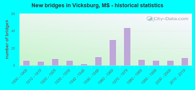
- New bridges - historical statistics
- 61900-1909
- 51910-1919
- 81920-1929
- 61930-1939
- 21940-1949
- 101950-1959
- 301960-1969
- 441970-1979
- 71980-1989
- 61990-1999
- 62000-2009
- 92010-2019

- Reconstructed bridges - Historical Statistics
- 11980-1989
- 01990-1999
- 02000-2009
- 12010-2019


- Bridge Condition - Deck
- 5.7%Very good
- 24.1%Good
- 32.2%Satisfactory
- 31.0%Fair
- 6.9%Poor

- Bridge Condition - Superstructure
- 13.0%Very good
- 41.3%Good
- 22.8%Satisfactory
- 18.5%Fair
- 4.3%Poor

- Bridge Condition - Substructure
- 10.9%Very good
- 38.0%Good
- 35.9%Satisfactory
- 14.1%Fair
- 1.1%Poor

- Bridge Condition - Channel
- 23.6%Very good
- 31.9%Good
- 30.6%Satisfactory
- 11.1%Fair
- 1.4%Poor
- 1.4%Serious

- Bridge Condition - Culverts
- 9.5%Very good
- 33.3%Good
- 47.6%Satisfactory
- 9.5%Fair
Find on map >> Show street view
Structure Number: 27000610751127, Location: 17.3 MI N CLAIBORNE CL (Lat: 32.309492, Lng: -90.887000), Route carried "under" structure: US 61, Year Built: 1971, Structure Length: 0. m, Average Daily Traffic: 6,800 (year 2017), Truck Traffic: 8%, Features Intersected: I 20 WEST TO US 61 SOUTH
Minimum Vertical Clearance: 4.77m (15.65ft), Kilometerpoint: 0.135, Lanes on structure: 2, Lanes under structure: 2, Material/Design: Steel continuous, Design/Construction: Stringer/Multi-beam, Length of Maximum Span: 51.8m (169.9ft)
Find on map >> Show street view
Structure Number: 27000610751175, Location: I 20/US 61 NORTH INCHG (Lat: 32.348489, Lng: -90.827931), Route carried "under" structure: Interstate 20, Year Built: 1960, Structure Length: 0. m, Average Daily Traffic: 17,000 (year 2017), Truck Traffic: 8%, Features Intersected: I 20 WB
Minimum Vertical Clearance: 5.20m (17.06ft), Kilometerpoint: 19.085, Lanes on structure: 2, Lanes under structure: 2, Material/Design: Concrete continuous, Design/Construction: Box Beam or Girders - Single/Spread, Length of Maximum Span: 21.3m (69.9ft)
Find on map >> Show street view
Structure Number: 4100020075001, Location: 1.0 MI E LA ST LINE (Lat: 32.310292, Lng: -90.899886), Route carried "under" structure: Interstate 20, Year Built: 1971, Structure Length: 0. m, Average Daily Traffic: 13,000 (year 2017), Truck Traffic: 20%, Features Intersected: I 20, Facility Carried by Structure: WASHINGTON STREET
Minimum Vertical Clearance: 4.94m (16.21ft), Kilometerpoint: 0.367, Lanes on structure: 5, Lanes under structure: 6, Material/Design: Steel continuous, Design/Construction: Stringer/Multi-beam, Length of Maximum Span: 39.6m (129.9ft)
Find on map >> Show street view
Structure Number: 41000610751189, Location: 1.5 MI N I 20 (Lat: 32.369719, Lng: -90.828011), Route carried "under" structure: US 61, Year Built: 1959, Structure Length: 0. m, Average Daily Traffic: 14,000 (year 2017), Truck Traffic: 8%, Features Intersected: US 61, Facility Carried by Structure: CULKIN ROAD
Minimum Vertical Clearance: 7.62m (25.00ft), Kilometerpoint: 12.835, Lanes on structure: 2, Lanes under structure: 4, Material/Design: Concrete continuous, Design/Construction: Box Beam or Girders - Single/Spread, Length of Maximum Span: 27.4m (89.9ft)
Find on map >> Show street view
Structure Number: 41000610751189, Location: 1.5 MI N I 20 (Lat: 32.369769, Lng: -90.827719), Route carried "under" structure: US 61, Year Built: 1959, Structure Length: 0. m, Average Daily Traffic: 14,000 (year 2017), Truck Traffic: 8%, Features Intersected: US 61, Facility Carried by Structure: CULKIN ROAD
Minimum Vertical Clearance: 7.01m (23.00ft), Kilometerpoint: 29.908, Lanes on structure: 2, Lanes under structure: 4, Material/Design: Concrete continuous, Design/Construction: Box Beam or Girders - Single/Spread, Length of Maximum Span: 27.4m (89.9ft)
Find on map >> Show street view
Structure Number: 51000200750024A, Location: 2.4 MI E LA ST LINE (Lat: 32.319281, Lng: -90.877514), Route carried "under" structure: Interstate 20, Year Built: 1971, Structure Length: 0. m, Average Daily Traffic: 18,500 (year 2017), Truck Traffic: 8%, Features Intersected: I 20, Facility Carried by Structure: HALLS FERRY ROAD
Minimum Vertical Clearance: 5.94m (19.49ft), Kilometerpoint: 0.541, Lanes on structure: 2, Lanes under structure: 4, Material/Design: Prestressed concrete, Design/Construction: Stringer/Multi-beam, Length of Maximum Span: 30.5m (100.1ft)
Find on map >> Show street view
Structure Number: 51000200750024A, Location: 2.4 MI E LA ST LINE (Lat: 32.319281, Lng: -90.877514), Route carried "under" structure: Interstate 20, Year Built: 1971, Structure Length: 0. m, Average Daily Traffic: 18,500 (year 2017), Truck Traffic: 20%, Features Intersected: I 20, Facility Carried by Structure: HALLS FERRY ROAD
Minimum Vertical Clearance: 6.34m (20.80ft), Kilometerpoint: 0.541, Lanes on structure: 2, Lanes under structure: 4, Material/Design: Prestressed concrete, Design/Construction: Stringer/Multi-beam, Length of Maximum Span: 30.5m (100.1ft)
Find on map >> Show street view
Structure Number: 51000200750024B, Location: 2.4 MI E LA ST LINE (Lat: 32.318319, Lng: -90.877283), Route carried "under" structure: Interstate 20, Year Built: 1971, Structure Length: 0. m, Average Daily Traffic: 18,500 (year 2017), Truck Traffic: 20%, Features Intersected: I 20, Facility Carried by Structure: HALLS FERRY ROAD
Minimum Vertical Clearance: 4.94m (16.21ft), Kilometerpoint: 15.678, Lanes on structure: 2, Lanes under structure: 4, Material/Design: Prestressed concrete, Design/Construction: Stringer/Multi-beam, Length of Maximum Span: 30.5m (100.1ft)
Find on map >> Show street view
Structure Number: 51000200750024B, Location: 2.4 MI E LA ST LINE (Lat: 32.318319, Lng: -90.877283), Route carried "under" structure: Interstate 20, Year Built: 1971, Structure Length: 0. m, Average Daily Traffic: 18,500 (year 2017), Truck Traffic: 20%, Features Intersected: I 20, Facility Carried by Structure: HALLS FERRY ROAD
Minimum Vertical Clearance: 5.43m (17.81ft), Kilometerpoint: 15.678, Lanes on structure: 2, Lanes under structure: 4, Material/Design: Prestressed concrete, Design/Construction: Stringer/Multi-beam, Length of Maximum Span: 30.5m (100.1ft)
Find on map >> Show street view
Structure Number: 51000200750029, Location: 2.9 MI E LA ST LINE (Lat: 32.322111, Lng: -90.868422), Route carried "under" structure: Interstate 20, Year Built: 1971, Structure Length: 0. m, Average Daily Traffic: 19,500 (year 2017), Truck Traffic: 20%, Features Intersected: I 20, Facility Carried by Structure: WISCONSIN AVE
Minimum Vertical Clearance: 5.82m (19.09ft), Kilometerpoint: 2.086, Lanes on structure: 2, Lanes under structure: 4, Material/Design: Prestressed concrete, Design/Construction: Stringer/Multi-beam, Length of Maximum Span: 27.4m (89.9ft)
Find on map >> Show street view
Structure Number: 51000200750029, Location: 2.9 MI E LA ST LINE (Lat: 32.322111, Lng: -90.868422), Route carried "under" structure: Interstate 20, Year Built: 1971, Structure Length: 0. m, Average Daily Traffic: 19,500 (year 2017), Truck Traffic: 20%, Features Intersected: I 20, Facility Carried by Structure: WISCONSIN AVE
Minimum Vertical Clearance: 5.09m (16.70ft), Kilometerpoint: 2.086, Lanes on structure: 2, Lanes under structure: 4, Material/Design: Prestressed concrete, Design/Construction: Stringer/Multi-beam, Length of Maximum Span: 27.4m (89.9ft)
Find on map >> Show street view
Structure Number: 51000200750029, Location: 2.9 MI E LA ST LINE (Lat: 32.322111, Lng: -90.868422), Route carried "under" structure: ServiceOther road 20, Year Built: 1971, Structure Length: 0. m, Average Daily Traffic: 3,500 (year 2017), Truck Traffic: 5%, Features Intersected: I 20, Facility Carried by Structure: WISCONSIN AVE
Minimum Vertical Clearance: 5.05m (16.57ft), Kilometerpoint: 2.086, Lanes on structure: 2, Lanes under structure: 4, Material/Design: Prestressed concrete, Design/Construction: Stringer/Multi-beam, Length of Maximum Span: 27.4m (89.9ft)
Find on map >> Show street view
Structure Number: 51000200750029, Location: 2.9 MI E LA ST LINE (Lat: 32.322111, Lng: -90.868422), Route carried "under" structure: ServiceOther road 20, Year Built: 1971, Structure Length: 0. m, Average Daily Traffic: 3,500 (year 2017), Truck Traffic: 5%, Features Intersected: I 20, Facility Carried by Structure: WISCONSIN AVE
Minimum Vertical Clearance: 4.82m (15.81ft), Kilometerpoint: 2.086, Lanes on structure: 2, Lanes under structure: 4, Material/Design: Prestressed concrete, Design/Construction: Stringer/Multi-beam, Length of Maximum Span: 27.4m (89.9ft)
Find on map >> Show street view
Structure Number: 51000200750035, Location: 3.5 MI E LA ST LINE (Lat: 32.330103, Lng: -90.861731), Route carried "under" structure: Interstate 20, Year Built: 1971, Structure Length: 0. m, Average Daily Traffic: 22,000 (year 2017), Truck Traffic: 8%, Features Intersected: I 20, Facility Carried by Structure: INDIANA AVE
Minimum Vertical Clearance: 4.91m (16.11ft), Kilometerpoint: 0.755, Lanes on structure: 2, Lanes under structure: 4, Material/Design: Prestressed concrete, Design/Construction: Stringer/Multi-beam, Length of Maximum Span: 27.4m (89.9ft)
Find on map >> Show street view
Structure Number: 51000200750035, Location: 3.5 MI E LA ST LINE (Lat: 32.330103, Lng: -90.861731), Route carried "under" structure: Interstate 20, Year Built: 1971, Structure Length: 0. m, Average Daily Traffic: 22,000 (year 2017), Truck Traffic: 8%, Features Intersected: I 20, Facility Carried by Structure: INDIANA AVE
Minimum Vertical Clearance: 5.03m (16.50ft), Kilometerpoint: 0.755, Lanes on structure: 2, Lanes under structure: 4, Material/Design: Prestressed concrete, Design/Construction: Stringer/Multi-beam, Length of Maximum Span: 27.4m (89.9ft)