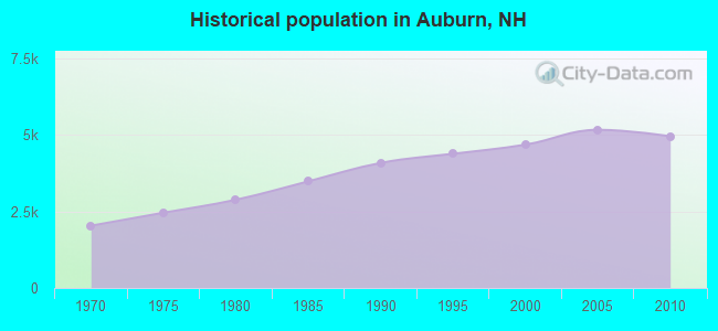
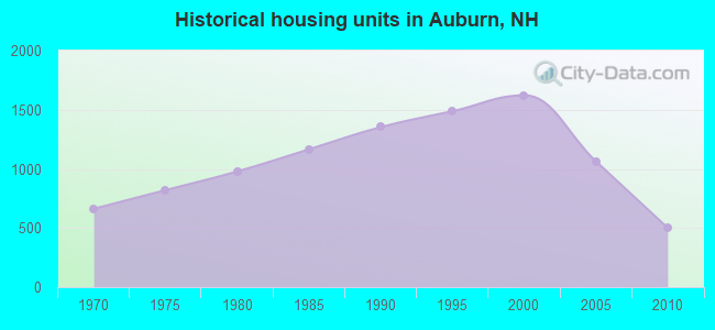
Auburn, New Hampshire
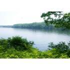
Auburn: Lake Masabesic from the trai
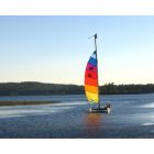
Auburn: Rainbow sails, Lake Massabesic, Auburn NH
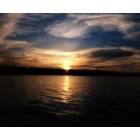
Auburn: Sunset over Lake Massabesic Auburn NH

Auburn: Lake Masabesic from the trail
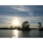
Auburn: Massabesic Lake Aug 2008
- add
your


Submit your own pictures of this town and show them to the world
- OSM Map
- General Map
- Google Map
- MSN Map
Population change since 2000: +5.8%
 |
| Males: 2,504 | |
| Females: 2,449 |
| Median resident age: | 43.5 years |
| New Hampshire median age: | 43.9 years |
Zip codes: 03032.
| Auburn: | $130,767 |
| NH: | $89,992 |
Estimated per capita income in 2022: $62,352 (it was $28,405 in 2000)
Auburn town income, earnings, and wages data
Estimated median house or condo value in 2022: $456,505 (it was $149,400 in 2000)
| Auburn: | $456,505 |
| NH: | $384,700 |
Mean prices in 2022: all housing units: $614,227; detached houses: $665,470; townhouses or other attached units: $408,866; in 2-unit structures: $730,084; in 3-to-4-unit structures: over $1,000,000; in 5-or-more-unit structures: $329,099; mobile homes: $126,160
Detailed information about poverty and poor residents in Auburn, NH

Compare current foreclosures near Auburn, NH:
| Photo | Address | Area | Beds / Baths | Price | Details |
|---|---|---|---|---|---|

|
#1
Shore Dr
Hampstead, NH 03841
|
787 sq. feet
|
1 baths 2 beds |
$529,900
|
show details |

|
#2
Hemlock Cir
Sandown, NH 03873
|
1,912 sq. feet
|
2 baths 4 beds |
show details | |

|
#3
S Mammoth Rd
Manchester, NH 03109
|
1,555 sq. feet
|
2 baths 4 beds |
show details | |

|
#4
Fieldstone Dr
Amherst, NH 03031
|
2,280 sq. feet
|
3 baths 3 beds |
show details | |

|
#5
Cheney Dr
Hudson, NH 03051
|
1,685 sq. feet
|
2 baths 3 beds |
show details | |

|
#6
Pine Ridge Rd
Windham, NH 03087
|
1,746 sq. feet
|
2 baths 4 beds |
show details | |

|
#7
High St
Derry, NH 03038
|
2,149 sq. feet
|
3 baths 4 beds |
show details | |

|
#8
Willow Creek Dr # 42
Hudson, NH 03051
|
1,120 sq. feet
|
1 baths 2 beds |
show details | |

|
#9
Blucher St
Manchester, NH 03102
|
2,448 sq. feet
|
2 baths 3 beds |
show details | |

|
#10
Brook St
Derry, NH 03038
|
1,476 sq. feet
|
2 baths 4 beds |
show details |
| Photo | Address | Area | Beds / Baths | Price | Details |
|---|---|---|---|---|---|

|
#11
Amherst St
Amherst, NH 03031
|
- sq. feet
|
4 baths 3 beds |
show details | |

|
#12
Granite St
Manchester, NH 03102
|
1,905 sq. feet
|
2 baths 4 beds |
show details | |

|
#13
Church St
Goffstown, NH 03045
|
2,115 sq. feet
|
2 baths 4 beds |
show details | |

|
#14
Beede Hill Rd
Fremont, NH 03044
|
1,135 sq. feet
|
1 baths 3 beds |
show details | |

|
#15
Windbrook Dr
Epping, NH 03042
|
1,680 sq. feet
|
1 baths 3 beds |
show details | |

|
#16
Page St
Manchester, NH 03104
|
4,105 sq. feet
|
3 baths 5 beds |
show details | |

|
#17
Twin Fawn Run
Chester, NH 03036
|
2,046 sq. feet
|
1 baths 3 beds |
show details | |

|
#18
Sanborn Rd
Derry, NH 03038
|
1,082 sq. feet
|
2 baths 2 beds |
show details | |

|
#19
Channel Ln
Goffstown, NH 03045
|
812 sq. feet
|
1 baths 2 beds |
show details | |

|
#20
Hidden Ranch Dr
Hooksett, NH 03106
|
903 sq. feet
|
1 baths 1 beds |
show details |
| Photo | Address | Area | Beds / Baths | Price | Details |
|---|---|---|---|---|---|

|
#21
Old Manchester Rd
Amherst, NH 03031
|
1,776 sq. feet
|
2 baths 3 beds |
show details | |

|
#22
Hamilton Ln
Salem, NH 03079
|
2,818 sq. feet
|
2 baths 4 beds |
show details | |

|
#23
Walnut Hill Rd
Derry, NH 03038
|
2,042 sq. feet
|
2 baths 3 beds |
show details | |

|
#24
Wedgewood Cir Unit 9
Hooksett, NH 03106
|
1,942 sq. feet
|
2 baths 2 beds |
show details | |

|
#25
Pinard St
Manchester, NH 03102
|
2,028 sq. feet
|
2 baths 5 beds |
show details | |

|
#26
Providence Hill Rd
Atkinson, NH 03811
|
1,947 sq. feet
|
1 baths 3 beds |
show details | |

|
#27
Hayden Dr
Atkinson, NH 03811
|
7,205 sq. feet
|
3 baths 4 beds |
show details | |

|
#28
Pimlico Ct # 91
Bedford, NH 03110
|
1,836 sq. feet
|
1 baths 2 beds |
show details | |

|
#29
Pimlico Ct
Bedford, NH 03110
|
1,836 sq. feet
|
1 baths 2 beds |
show details | |

|
#30
Sheridan St
Manchester, NH 03102
|
1,872 sq. feet
|
2 baths 4 beds |
show details |
| Photo | Address | Area | Beds / Baths | Price | Details |
|---|---|---|---|---|---|

|
#31
Rockland Ave
Manchester, NH 03102
|
1,870 sq. feet
|
1 baths 3 beds |
show details | |

|
#32
Tsienneto Rd Unit 39
Derry, NH 03038
|
1,936 sq. feet
|
1 baths 2 beds |
show details | |

|
#33
Webster St
Salem, NH 03079
|
1,912 sq. feet
|
2 baths 3 beds |
show details | |

|
#34
Wiley Hill Rd
Londonderry, NH 03053
|
2,668 sq. feet
|
2 baths 3 beds |
show details | |

|
#35
Moose Club Park Rd
Goffstown, NH 03045
|
1,864 sq. feet
|
2 baths 4 beds |
show details | |

|
#36
Haverhill Rd
Chester, NH 03036
|
2,702 sq. feet
|
3 baths 3 beds |
show details | |

|
#37
Brook St
Derry, NH 03038
|
1,666 sq. feet
|
1 baths 4 beds |
show details | |

|
#38
Gayle Dr
Derry, NH 03038
|
1,246 sq. feet
|
1 baths 3 beds |
show details | |

|
#39
Caron Rd
Bedford, NH 03110
|
1,960 sq. feet
|
2 baths 4 beds |
show details | |

|
#40
Pinnacle St
Hooksett, NH 03106
|
2,238 sq. feet
|
2 baths 3 beds |
show details |
| Photo | Address | Area | Beds / Baths | Price | Details |
|---|---|---|---|---|---|

|
#41
Fairview Ave
Derry, NH 03038
|
1,510 sq. feet
|
1 baths 3 beds |
show details | |

|
#42
Dunnington Way
Bedford, NH 03110
|
1,522 sq. feet
|
2 baths 4 beds |
show details | |

|
#43
Diamond Ln
Goffstown, NH 03045
|
2,464 sq. feet
|
1 baths 4 beds |
show details | |

|
#44
Dearborn Rd
Epping, NH 03042
|
1,768 sq. feet
|
2 baths 3 beds |
show details | |

|
#45
Brook St
Derry, NH 03038
|
1,476 sq. feet
|
1 baths 4 beds |
show details | |

|
#46
Longbrook Rd
Goffstown, NH 03045
|
1,960 sq. feet
|
2 baths 3 beds |
show details | |

|
#47
Cote Cir
Raymond, NH 03077
|
2,024 sq. feet
|
2 baths 3 beds |
show details | |

|
#48
Van Ger Dr
Bow, NH 03304
|
2,498 sq. feet
|
2 baths 3 beds |
show details | |

|
#49
Lawrence St
Derry, NH 03038
|
2,124 sq. feet
|
2 baths 3 beds |
show details | |

|
Check over 1 million property listings on Foreclosure.com!
|
browse all offers | |||

- 4,75496.0%White alone
- 871.8%Hispanic
- 440.9%Two or more races
- 390.8%Asian alone
- 130.3%Black alone
- 90.2%American Indian alone
- 70.1%Other race alone
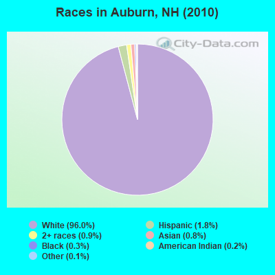
Races in Auburn detailed stats: ancestries, foreign born residents, place of birth
According to our research of New Hampshire and other state lists, there were 6 registered sex offenders living in Auburn, New Hampshire as of April 26, 2024.
The ratio of all residents to sex offenders in Auburn is 826 to 1.
The ratio of registered sex offenders to all residents in this city is lower than the state average.
Type |
2009 |
2010 |
2011 |
2012 |
2013 |
2014 |
2015 |
2016 |
2017 |
2018 |
2019 |
2020 |
2021 |
2022 |
|---|---|---|---|---|---|---|---|---|---|---|---|---|---|---|
| Murders (per 100,000) | 0 (0.0) | 2 (40.4) | 0 (0.0) | 0 (0.0) | 0 (0.0) | 0 (0.0) | 0 (0.0) | 0 (0.0) | 0 (0.0) | 0 (0.0) | 0 (0.0) | 0 (0.0) | 0 (0.0) | 0 (0.0) |
| Rapes (per 100,000) | 0 (0.0) | 0 (0.0) | 2 (40.3) | 0 (0.0) | 0 (0.0) | 0 (0.0) | 0 (0.0) | 2 (37.3) | 0 (0.0) | 1 (18.0) | 0 (0.0) | 0 (0.0) | 0 (0.0) | 0 (0.0) |
| Robberies (per 100,000) | 1 (19.2) | 0 (0.0) | 1 (20.2) | 1 (20.1) | 0 (0.0) | 1 (19.2) | 1 (18.9) | 0 (0.0) | 0 (0.0) | 0 (0.0) | 0 (0.0) | 1 (17.7) | 0 (0.0) | 0 (0.0) |
| Assaults (per 100,000) | 2 (38.3) | 0 (0.0) | 1 (20.2) | 4 (80.3) | 2 (39.0) | 2 (38.3) | 2 (37.7) | 3 (55.9) | 0 (0.0) | 1 (18.0) | 2 (35.7) | 1 (17.7) | 2 (34.7) | 1 (16.4) |
| Burglaries (per 100,000) | 12 (230.1) | 32 (646.1) | 45 (907.4) | 28 (562.2) | 32 (623.5) | 24 (460.1) | 11 (207.4) | 19 (353.9) | 7 (128.5) | 10 (179.7) | 7 (124.8) | 4 (70.6) | 2 (34.7) | 0 (0.0) |
| Thefts (per 100,000) | 32 (613.5) | 50 (1,009) | 42 (846.9) | 85 (1,707) | 40 (779.4) | 24 (460.1) | 42 (792.0) | 33 (614.8) | 31 (568.9) | 21 (377.4) | 27 (481.5) | 43 (759.4) | 32 (554.5) | 24 (394.1) |
| Auto thefts (per 100,000) | 0 (0.0) | 1 (20.2) | 9 (181.5) | 1 (20.1) | 1 (19.5) | 1 (19.2) | 4 (75.4) | 1 (18.6) | 1 (18.4) | 0 (0.0) | 3 (53.5) | 5 (88.3) | 8 (138.6) | 2 (32.8) |
| Arson (per 100,000) | 5 (95.9) | 0 (0.0) | 0 (0.0) | 1 (20.1) | 1 (19.5) | 0 (0.0) | 1 (18.9) | 0 (0.0) | 0 (0.0) | 1 (18.0) | 0 (0.0) | 0 (0.0) | 0 (0.0) | 1 (16.4) |
| City-Data.com crime index | 54.1 | 168.0 | 154.3 | 131.3 | 84.2 | 65.6 | 65.4 | 91.8 | 33.2 | 45.7 | 39.4 | 51.2 | 42.6 | 21.7 |
The City-Data.com crime index weighs serious crimes and violent crimes more heavily. Higher means more crime, U.S. average is 246.1. It adjusts for the number of visitors and daily workers commuting into cities.
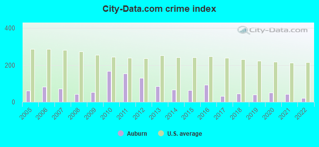
Crime rate in Auburn detailed stats: murders, rapes, robberies, assaults, burglaries, thefts, arson
Full-time law enforcement employees in 2021, including police officers: 12 (10 officers - 9 male; 1 female).
| Officers per 1,000 residents here: | 1.73 |
| New Hampshire average: | 2.14 |
 Recent articles from our blog. Our writers, many of them Ph.D. graduates or candidates, create easy-to-read articles on a wide variety of topics.


 | Manchester Suburbs (15 replies) |
| Moving to New Hampshire (Lebanon, Hanover, Keene, Grantham, Plainfield, Enfield, Etna) (38 replies) |
| What do you know about Auburn? (1 reply) |
| Auburn, Hooksett & Pinkerton Academy (0 replies) |
| Moving to Auburn, need lots o' recs (yes another one of these, lol) (2 replies) |
| Thinking about moving from Arizona to New Hampshire (24 replies) |
Latest news from Auburn, NH collected exclusively by city-data.com from local newspapers, TV, and radio stations
Ancestries: Irish (25.2%), French (20.0%), English (19.4%), French Canadian (16.7%), Italian (9.3%), German (8.4%).
Current Local Time: EST time zone
Incorporated in 1845
Elevation: 257 feet
Land area: 25.2 square miles.
Population density: 196 people per square mile (very low).
102 residents are foreign born (0.7% Europe, 0.7% North America, 0.6% Latin America).
| This town: | 2.2% |
| New Hampshire: | 4.4% |
| Auburn town: | 1.8% ($2,683) |
| New Hampshire: | 2.3% ($2,946) |
Nearest city with pop. 50,000+: Manchester, NH  (5.2 miles , pop. 107,006).
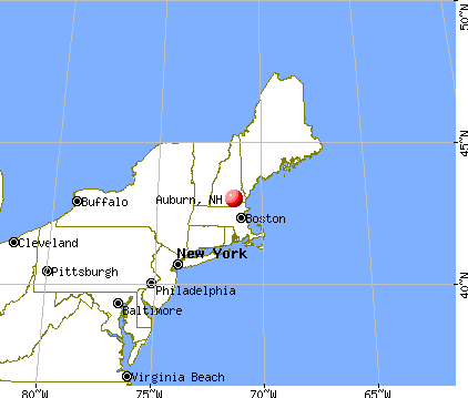
Nearest city with pop. 200,000+: Boston, MA (48.8 miles , pop. 589,141).
Nearest city with pop. 1,000,000+: Bronx, NY (197.5 miles , pop. 1,332,650).
Nearest cities:
), ), ), ), )Latitude: 43.00 N, Longitude: 71.35 W
Area code commonly used in this area: 603

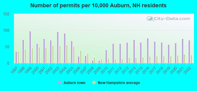
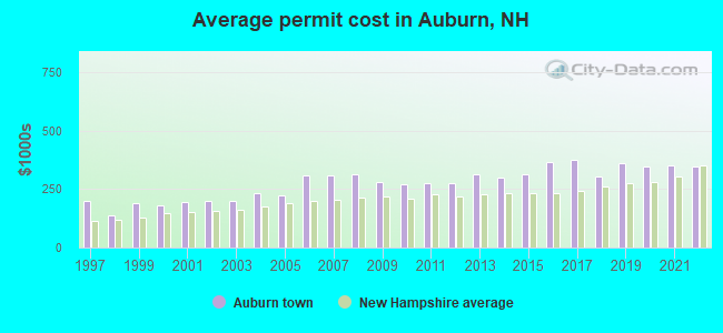
Single-family new house construction building permits:
- 2022: 33 buildings, average cost: $348,200
- 2021: 35 buildings, average cost: $349,500
- 2020: 29 buildings, average cost: $344,800
- 2019: 27 buildings, average cost: $361,200
- 2018: 30 buildings, average cost: $301,900
- 2017: 31 buildings, average cost: $373,600
- 2016: 36 buildings, average cost: $367,200
- 2015: 30 buildings, average cost: $313,500
- 2014: 34 buildings, average cost: $296,900
- 2013: 30 buildings, average cost: $314,900
- 2012: 28 buildings, average cost: $274,500
- 2011: 28 buildings, average cost: $274,800
- 2010: 19 buildings, average cost: $271,700
- 2009: 4 buildings, average cost: $279,700
- 2008: 4 buildings, average cost: $311,400
- 2007: 11 buildings, average cost: $305,500
- 2006: 10 buildings, average cost: $306,900
- 2005: 32 buildings, average cost: $223,000
- 2004: 43 buildings, average cost: $232,200
- 2003: 45 buildings, average cost: $198,700
- 2002: 33 buildings, average cost: $200,200
- 2001: 35 buildings, average cost: $195,300
- 2000: 28 buildings, average cost: $178,000
- 1999: 46 buildings, average cost: $189,000
- 1998: 34 buildings, average cost: $139,000
- 1997: 17 buildings, average cost: $199,000
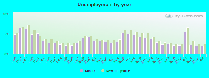
| Here: | 2.1% |
| New Hampshire: | 2.5% |

- Construction (9.1%)
- Health care (7.2%)
- Professional, scientific, technical services (6.9%)
- Finance & insurance (6.3%)
- Computer & electronic products (5.7%)
- Educational services (5.2%)
- Public administration (4.5%)
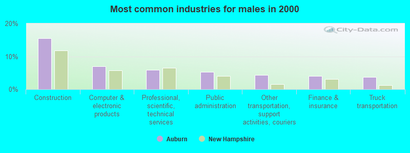
- Construction (15.5%)
- Computer & electronic products (7.0%)
- Professional, scientific, technical services (5.9%)
- Public administration (5.3%)
- Other transportation, support activities, couriers (4.4%)
- Finance & insurance (4.0%)
- Truck transportation (3.7%)
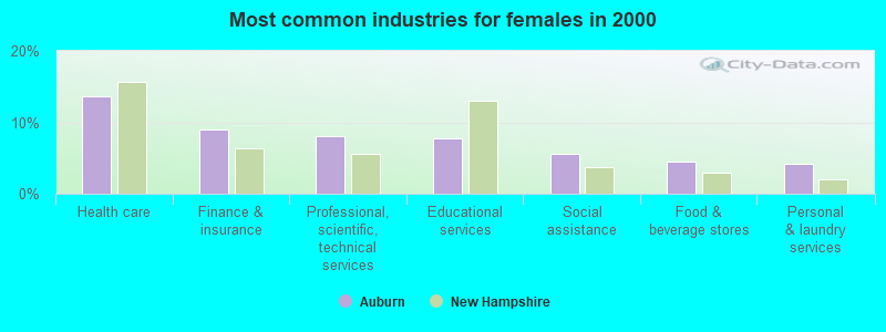
- Health care (13.7%)
- Finance & insurance (9.1%)
- Professional, scientific, technical services (8.0%)
- Educational services (7.8%)
- Social assistance (5.6%)
- Food & beverage stores (4.6%)
- Personal & laundry services (4.2%)
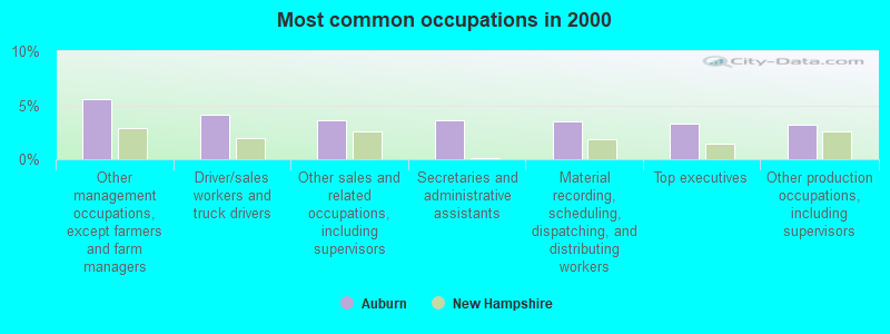
- Other management occupations, except farmers and farm managers (5.5%)
- Driver/sales workers and truck drivers (4.1%)
- Other sales and related occupations, including supervisors (3.6%)
- Secretaries and administrative assistants (3.6%)
- Material recording, scheduling, dispatching, and distributing workers (3.5%)
- Top executives (3.3%)
- Other production occupations, including supervisors (3.2%)
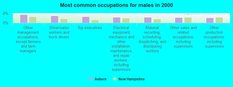
- Other management occupations, except farmers and farm managers (7.0%)
- Driver/sales workers and truck drivers (6.1%)
- Top executives (5.3%)
- Electrical equipment mechanics and other installation, maintenance, and repair workers, including supervisors (4.9%)
- Material recording, scheduling, dispatching, and distributing workers (4.8%)
- Other sales and related occupations, including supervisors (4.7%)
- Other production occupations, including supervisors (4.3%)
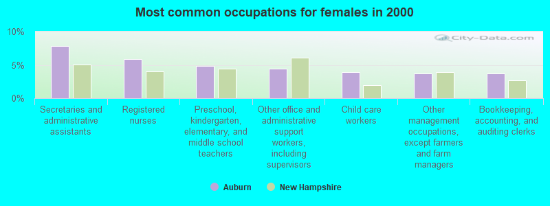
- Secretaries and administrative assistants (7.8%)
- Registered nurses (5.9%)
- Preschool, kindergarten, elementary, and middle school teachers (4.8%)
- Other office and administrative support workers, including supervisors (4.4%)
- Child care workers (3.9%)
- Other management occupations, except farmers and farm managers (3.8%)
- Bookkeeping, accounting, and auditing clerks (3.7%)
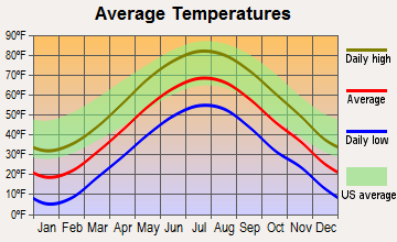
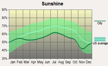
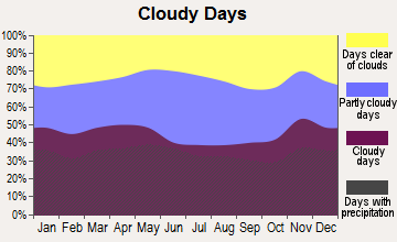
Average climate in Auburn, New Hampshire
Based on data reported by over 4,000 weather stations
(lower is better)
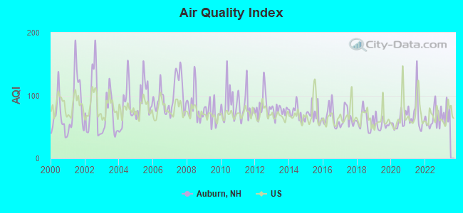
Air Quality Index (AQI) level in 2022 was 63.8. This is about average.
| City: | 63.8 |
| U.S.: | 72.6 |
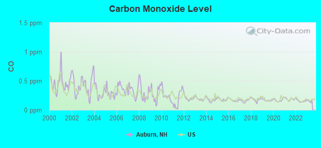
Carbon Monoxide (CO) [ppm] level in 2022 was 0.157. This is significantly better than average. Closest monitor was 5.5 miles away from the city center.
| City: | 0.157 |
| U.S.: | 0.251 |
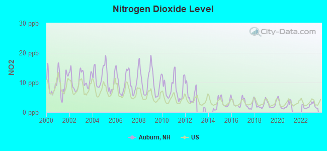
Nitrogen Dioxide (NO2) [ppb] level in 2022 was 2.05. This is significantly better than average. Closest monitor was 5.5 miles away from the city center.
| City: | 2.05 |
| U.S.: | 5.11 |
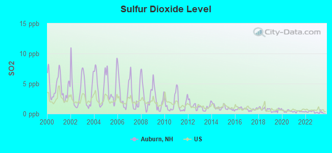
Sulfur Dioxide (SO2) [ppb] level in 2022 was 0.338. This is significantly better than average. Closest monitor was 5.2 miles away from the city center.
| City: | 0.338 |
| U.S.: | 1.515 |
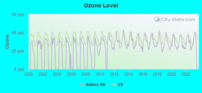
Ozone [ppb] level in 2022 was 29.6. This is about average. Closest monitor was 5.5 miles away from the city center.
| City: | 29.6 |
| U.S.: | 33.3 |
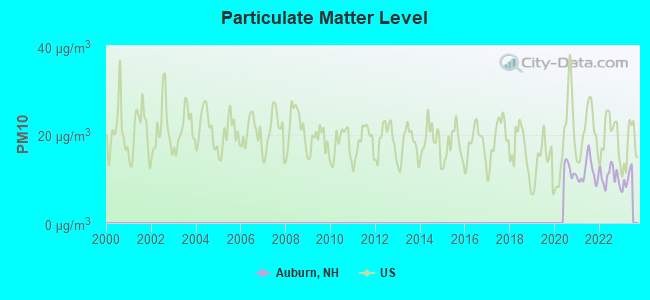
Particulate Matter (PM10) [µg/m3] level in 2022 was 10.6. This is significantly better than average. Closest monitor was 5.5 miles away from the city center.
| City: | 10.6 |
| U.S.: | 19.2 |
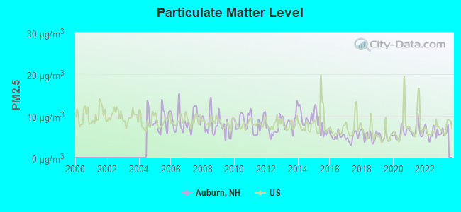
Particulate Matter (PM2.5) [µg/m3] level in 2022 was 5.92. This is better than average. Closest monitor was 5.6 miles away from the city center.
| City: | 5.92 |
| U.S.: | 8.11 |
Tornado activity:
Auburn-area historical tornado activity is slightly above New Hampshire state average. It is 40% smaller than the overall U.S. average.
On 6/9/1953, a category F3 (max. wind speeds 158-206 mph) tornado 19.4 miles away from the Auburn town center injured 5 people and caused between $5000 and $50,000 in damages.
On 9/29/1974, a category F3 tornado 27.4 miles away from the town center injured one person and caused between $50,000 and $500,000 in damages.
Earthquake activity:
Auburn-area historical earthquake activity is significantly above New Hampshire state average. It is 72% smaller than the overall U.S. average.On 4/20/2002 at 10:50:47, a magnitude 5.3 (5.3 ML, Depth: 3.0 mi, Class: Moderate, Intensity: VI - VII) earthquake occurred 157.1 miles away from the city center
On 10/7/1983 at 10:18:46, a magnitude 5.3 (5.1 MB, 5.3 LG, 5.1 ML) earthquake occurred 163.9 miles away from Auburn center
On 1/19/1982 at 00:14:42, a magnitude 4.7 (4.5 MB, 4.7 MD, 4.5 LG, Class: Light, Intensity: IV - V) earthquake occurred 36.8 miles away from the city center
On 4/20/2002 at 10:50:47, a magnitude 5.2 (5.2 MB, 4.2 MS, 5.2 MW, 5.0 MW) earthquake occurred 156.7 miles away from the city center
On 10/16/2012 at 23:12:25, a magnitude 4.7 (4.7 ML, Depth: 10.0 mi) earthquake occurred 54.1 miles away from Auburn center
On 8/21/1996 at 07:54:14, a magnitude 3.8 (3.8 LG, 3.6 LG, Depth: 6.2 mi, Class: Light, Intensity: II - III) earthquake occurred 81.9 miles away from the city center
Magnitude types: regional Lg-wave magnitude (LG), body-wave magnitude (MB), duration magnitude (MD), local magnitude (ML), surface-wave magnitude (MS), moment magnitude (MW)
Natural disasters:
The number of natural disasters in Rockingham County (26) is a lot greater than the US average (15).Major Disasters (Presidential) Declared: 17
Emergencies Declared: 9
Causes of natural disasters: Storms: 12, Floods: 9, Winter Storms: 5, Hurricanes: 4, Snowstorms: 4, Snows: 2, Winds: 2, Blizzard: 1, Snowfall: 1, Tornado: 1 (Note: some incidents may be assigned to more than one category).

Hospitals and medical centers in Auburn:
Other hospitals and medical centers near Auburn:
- VILLA CREST (Nursing Home, about 4 miles away; MANCHESTER, NH)
- LAKE SHORE HOSPITAL, INC (Hospital, about 4 miles away; MANCHESTER, NH)
- HOLY CROSS HEALTH CENTER (Nursing Home, about 4 miles away; MANCHESTER, NH)
- ST JOSEPH RESIDENCE (Nursing Home, about 5 miles away; MANCHESTER, NH)
- MAMMOTH NURSING HOME (Nursing Home, about 5 miles away; MANCHESTER, NH)
- HANOVER HILL HEALTH CARE CENTER (Nursing Home, about 5 miles away; MANCHESTER, NH)
- ELLIOT HOSPITAL Acute Care Hospitals (about 5 miles away; MANCHESTER, NH)
Airports located in Auburn:
- Cleary Airport (29NH) (Runways: 1)
Colleges/universities with over 2000 students nearest to Auburn:
- Southern New Hampshire University (about 6 miles; Manchester, NH; Full-time enrollment: 16,552)
- Mount Washington College (about 7 miles; Manchester, NH; FT enrollment: 2,187)
- Saint Anselm College (about 9 miles; Manchester, NH; FT enrollment: 2,059)
- NHTI-Concord's Community College (about 18 miles; Concord, NH; FT enrollment: 2,865)
- Northern Essex Community College (about 21 miles; Haverhill, MA; FT enrollment: 4,737)
- University of New Hampshire-Main Campus (about 24 miles; Durham, NH; FT enrollment: 15,243)
- University of Massachusetts-Lowell (about 25 miles; Lowell, MA; FT enrollment: 12,341)
Public elementary/middle school in Auburn:
- AUBURN VILLAGE SCHOOL (Students: 600, Location: 11 EATON HILL RD., Grades: KG-8)
Points of interest:
Notable locations in Auburn: Auburn Railroad Station (A), Auburn Fire Department Station 2 (B), Auburn Fire Department Station 1 (C), Griffin Free Public Library (D). Display/hide their locations on the map
Churches in Auburn include: Saint Peter Parish Church (A), Long Meadow Church (B). Display/hide their locations on the map
Cemeteries: Long Meadow Cemetery (1), Auburn Cemetery (2). Display/hide their locations on the map
Lakes, reservoirs, and swamps: Calef Pond (A), Little Massabesic Lake (B), Massabesic Lake (C), Spruce Lakes (D), Clark Pond (E), Spruce Swamp (F). Display/hide their locations on the map
Streams, rivers, and creeks: Sucker Brook (A), Preston Brook (B), Murray Mill Brook (C), Maple Falls Brook (D), Little Massabesic Brook (E), Hook Brook (F), Clark Pond Brook (G), Canfield Brook (H). Display/hide their locations on the map
Tourist attraction: The Wild Bird Emporium (Recreation Areas; 6 Olde Towne Road) (1). Display/hide its approximate location on the map
Courts: Auburn District Court - Criminal DIV (5 Priscilla Lane) (1), Auburn District Court - Civil & Juvenile (5 Priscilla Lane) (2). Display/hide their approximate locations on the map
Birthplace of: Carl Forsaith - History book author.
Drinking water stations with addresses in Auburn and their reported violations in the past:
WEST EPPING VILLAGE MARKET (Population served: 30, Groundwater):Past health violations:Past monitoring violations:
- MCL, Single Sample - Between APR-2012 and JUN-2012, Contaminant: Nitrate. Follow-up actions: St Public Notif requested (JUL-09-2012), St Violation/Reminder Notice (JUL-09-2012), St Public Notif received (JUL-09-2012), St Compliance achieved (SEP-11-2012)
- One routine major monitoring violation
| This town: | 2.8 people |
| New Hampshire: | 2.5 people |
| This town: | 81.9% |
| Whole state: | 66.3% |
| This town: | 5.6% |
| Whole state: | 8.3% |
Likely homosexual households (counted as self-reported same-sex unmarried-partner households)
- Lesbian couples: 0.2% of all households
- Gay men: 0.4% of all households
| This town: | 1.8% |
| Whole state: | 6.5% |
| This town: | 1.1% |
| Whole state: | 2.8% |
4 people in other noninstitutional group quarters in 2000
3 people in religious group quarters in 2000
For population 15 years and over in Auburn:
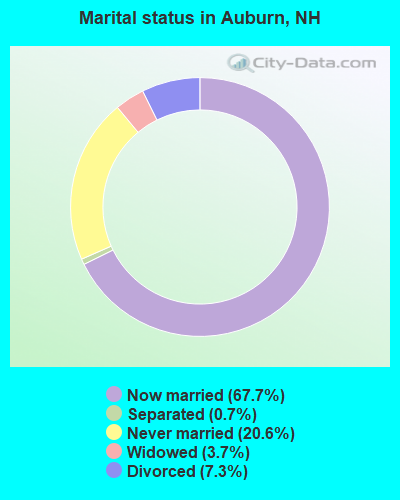
- Never married: 20.6%
- Now married: 67.7%
- Separated: 0.7%
- Widowed: 3.7%
- Divorced: 7.3%
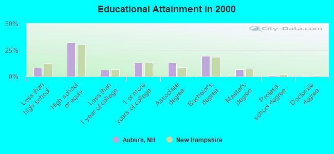
For population 25 years and over in Auburn:
- High school or higher: 91.7%
- Bachelor's degree or higher: 27.0%
- Graduate or professional degree: 7.8%
- Unemployed: 2.5%
- Mean travel time to work (commute): 26.7 minutes
| Here: | 9.5 |
| New Hampshire average: | 10.9 |


Graphs represent county-level data. Detailed 2008 Election Results
Religion statistics for Auburn, NH (based on Rockingham County data)


| Religion | Adherents | Congregations |
|---|---|---|
| Catholic | 84,697 | 24 |
| Mainline Protestant | 19,072 | 78 |
| Evangelical Protestant | 7,456 | 61 |
| Other | 3,490 | 20 |
| Orthodox | 200 | 1 |
| None | 180,308 | - |
Food Environment Statistics:
| Rockingham County: | 1.59 / 10,000 pop. |
| New Hampshire: | 2.14 / 10,000 pop. |
| This county: | 0.17 / 10,000 pop. |
| State: | 0.15 / 10,000 pop. |
| Rockingham County: | 1.86 / 10,000 pop. |
| New Hampshire: | 1.78 / 10,000 pop. |
| Rockingham County: | 3.31 / 10,000 pop. |
| State: | 4.02 / 10,000 pop. |
| Here: | 9.56 / 10,000 pop. |
| State: | 9.70 / 10,000 pop. |
| This county: | 7.6% |
| New Hampshire: | 7.6% |
| Rockingham County: | 23.3% |
| New Hampshire: | 24.4% |
| This county: | 16.8% |
| State: | 15.9% |
7.69% of this county's 2021 resident taxpayers lived in other counties in 2020 ($114,534 average adjusted gross income)
| Here: | 7.69% |
| New Hampshire average: | 7.66% |
0.01% of residents moved from foreign countries ($203 average AGI)
Rockingham County: 0.01% New Hampshire average: 0.01%
Top counties from which taxpayers relocated into this county between 2020 and 2021:
| from Essex County, MA | |
| from Hillsborough County, NH | |
| from Middlesex County, MA |
6.82% of this county's 2020 resident taxpayers moved to other counties in 2021 ($88,778 average adjusted gross income)
| Here: | 6.82% |
| New Hampshire average: | 6.80% |
0.01% of residents moved to foreign countries ($126 average AGI)
Rockingham County: 0.01% New Hampshire average: 0.01%
Top counties to which taxpayers relocated from this county between 2020 and 2021:
| to Hillsborough County, NH | |
| to Strafford County, NH | |
| to Essex County, MA |
Businesses in Auburn, NH
- Dunkin Donuts: 1
- FedEx: 1
- UPS: 1
Strongest AM radio stations in Auburn:
- WGIR (610 AM; 5 kW; MANCHESTER, NH; Owner: CAPSTAR TX LIMITED PARTNERSHIP)
- WDER (1320 AM; 10 kW; DERRY, NH; Owner: BLOUNT COMMUNICATIONS, INC. OF NH)
- WKBR (1250 AM; 5 kW; MANCHESTER, NH; Owner: DEVON BROADCASTING COMPANY, INC.)
- WRKO (680 AM; 50 kW; BOSTON, MA; Owner: ENTERCOM BOSTON LICENSE, LLC)
- WFEA (1370 AM; 5 kW; MANCHESTER, NH; Owner: SAGA COMMUNICATIONS OF NEW ENGLAND, LLC)
- WEEI (850 AM; 50 kW; BOSTON, MA; Owner: ENTERCOM BOSTON LICENSE, LLC)
- WWZN (1510 AM; 50 kW; BOSTON, MA; Owner: ROSE CITY RADIO CORPORATION)
- WKOX (1200 AM; 50 kW; FRAMINGHAM, MA; Owner: CAPSTAR TX LIMITED PARTNERSHIP)
- WCRN (830 AM; 50 kW; WORCESTER, MA; Owner: CARTER BROADCASTING CORPORATION)
- WBZ (1030 AM; 50 kW; BOSTON, MA; Owner: INFINITY BROADCASTING OPERATIONS, INC.)
- WCEC (1110 AM; daytime; 5 kW; SALEM, NH; Owner: COSTA-EAGLE RADIO VENTURES LTD PARTNERSHIP)
- WBIX (1060 AM; 40 kW; NATICK, MA; Owner: LANGER BROADCASTING CORPORATION)
- WGIN (930 AM; 10 kW; ROCHESTER, NH; Owner: CAPSTAR TX LIMITED PARTNERSHIP)
Strongest FM radio stations in Auburn:
- WGIR-FM (101.1 FM; MANCHESTER, NH; Owner: CAPSTAR TX LIMITED PARTNERSHIP)
- WQLL (96.5 FM; BEDFORD, NH; Owner: SAGA COMMUNICATIONS OF NEW ENGLAND, LLC)
- WLMW (90.7 FM; MANCHESTER, NH; Owner: KNOWLEDGE FOR LIFE)
- WZID (95.7 FM; MANCHESTER, NH; Owner: SAGA COMMUNICATIONS OF NEW ENGLAND, LLC)
- WFEX (92.1 FM; PETERBOROUGH, NH; Owner: FNX BROADCASTING OF NEW HAMPSHIRE LLC)
- W282AF (104.3 FM; CONCORD, NH; Owner: CONCORD BIBLE FELLOWSHIP)
- WXRV (92.5 FM; HAVERHILL, MA; Owner: BEANPOT BROADCASTING CORP.)
- WNHI (93.3 FM; BELMONT, NH; Owner: CONCORD BROADCASTING, L.L.C.)
- WHOB (106.3 FM; NASHUA, NH; Owner: TELE-MEDIA COMPANY OF NEW HAMPSHIRE, L.L.C.)
- W250AB (97.9 FM; MANCHESTER, NH; Owner: CITADEL BROADCASTING COMPANY)
- WHDQ (106.1 FM; CLAREMONT, NH; Owner: GREAT NORTHERN RADIO, L.L.C.)
- WSCY (106.9 FM; MOULTONBOROUGH, NH; Owner: NORTHEAST COMMUNICATIONS CORPORATION)
- WPKQ (103.7 FM; NORTH CONWAY, NH; Owner: CITADEL BROADCASTING COMPANY)
- WKLB-FM (99.5 FM; LOWELL, MA; Owner: GREATER BOSTON RADIO, INC.)
- WNNH (99.1 FM; HENNIKER, NH; Owner: TELE-MEDIA COMPANY OF NEW HAMPSHIRE, L.L.C.)
- WMEX (106.5 FM; FARMINGTON, NH; Owner: WIMMEX, LLC)
- WVPR (89.5 FM; WINDSOR, VT; Owner: VERMONT PUBLIC RADIO)
- WJYY (105.5 FM; CONCORD, NH; Owner: CONCORD BROADCASTING, L.L.C.)
- WLKZ (104.9 FM; WOLFEBORO, NH; Owner: TELE-MEDIA COMPANY OF NEW HAMPSHIRE, L.L.C.)
- W227AM (93.3 FM; ANDOVER, MA; Owner: GREATER BOSTON RADIO, INC.)
TV broadcast stations around Auburn:
- WENH-TV (Channel 11; DURHAM, NH; Owner: UNIVERSITY OF NEW HAMPSHIRE)
- WFXZ-CA (Channel 24; BOSTON, MA; Owner: BOSTON BROADCASTING CORP.)
- WMEA-TV (Channel 26; BIDDEFORD, ME; Owner: MAINE PUBLIC BROADCASTING CORP.)
- WHDN-LP (Channel 26; BOSTON, MA; Owner: GUENTER MARKSTEINER)
- WNDS (Channel 50; DERRY, NH; Owner: CTV OF DERRY, INC)
- WCVB-TV (Channel 5; BOSTON, MA; Owner: WCVB HEARST-ARGYLE TV, INC.)
- WGBH-TV (Channel 2; BOSTON, MA; Owner: WGBH EDUCATIONAL FOUNDATION)
- WPXG (Channel 21; CONCORD, NH; Owner: PAXSON BOSTON-68 LICENSE, INC.)
- WMUR-TV (Channel 9; MANCHESTER, NH; Owner: HEARST-ARGYLE PROPERTIES, INC.)
- W29AT (Channel 29; MANCHESTER, NH; Owner: CENTER BROADCASTING CORP. OF NEW HAMPSHIRE)
- WUTF (Channel 66; MARLBOROUGH, MA; Owner: TELEFUTURA BOSTON LLC)
- WMFP (Channel 62; LAWRENCE, MA; Owner: WSAH LICENSE, INC.)
- WBZ-TV (Channel 4; BOSTON, MA; Owner: VIACOM INC.)
- WGBX-TV (Channel 44; BOSTON, MA; Owner: WGBH EDUCATIONAL FOUNDATION)
- WUNI (Channel 27; WORCESTER, MA; Owner: ENTRAVISION HOLDINGS, LLC)
- WSBK-TV (Channel 38; BOSTON, MA; Owner: VIACOM INC.)
- WLVI-TV (Channel 56; CAMBRIDGE, MA; Owner: WLVI, INC.)
- WNEU (Channel 60; MERRIMACK, NH; Owner: NBC SUBSIDIARY (NH), INC.)

- National Bridge Inventory (NBI) Statistics
- 15Number of bridges
- 59ft / 18.0mTotal length
- $31,420,000Total costs
- 157,043Total average daily traffic
- 11,489Total average daily truck traffic
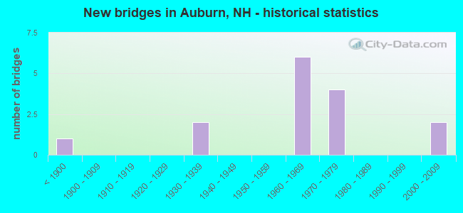
- New bridges - historical statistics
- 1Before 1900
- 21930-1939
- 61960-1969
- 41970-1979
- 22000-2009
FCC Registered Antenna Towers:
6- David J Fenton, 34 Leppert Way (Lat: 42.957028 Lon: -71.360361), Type: 60.9, Overall height: 57.9 m, Registrant: Kevin.Delaney@induscom.Com, Phone: (781) 319-1011
- David J Fenton, 34 Leppert Way (Lat: 42.957028 Lon: -71.360361), Type: 60.9, Overall height: 57.9 m, Registrant: Kevin.Delaney@induscom.Com, Phone: (781) 319-1011
- Michael J Umano, 34 Leppert Way (Lat: 42.957222 Lon: -71.360139), Type: 60.9, Structure height: 33015 m, Overall height: 57.9 m, Registrant: Industrial Tower And Wireless, LLC, Kevin.Delaney@induscom.Com, , 40 Lo-ne Street, Phone: (781) 319-1011
- Michael J Umano, 34 Leppert Way (Lat: 42.957222 Lon: -71.360139), Type: 60.9, Structure height: 33015 m, Overall height: 57.9 m, Registrant: Industrial Tower And Wireless, LLC, Kevin.Delaney@induscom.Com, , 40 Lo-ne Street, Phone: (781) 319-1011
- Michael J Umano, 34 Leppert Way (Lat: 42.957222 Lon: -71.360139), Type: 60.9, Structure height: 33015 m, Overall height: 57.9 m, Registrant: Industrial Tower And Wireless, LLC, Kevin.Delaney@itwllc.Com, , Marsh-field, Phone: (781) 319-1011
- Michael J Umano, 34 Leppert Way (Lat: 42.957222 Lon: -71.360139), Type: 60.9, Structure height: 33015 m, Overall height: 57.9 m, Registrant: Industrial Tower And Wireless, LLC, Kevin.Delaney@itwllc.Com, , Marsh-field, Phone: (781) 319-1011
FCC Registered Broadcast Land Mobile Towers:
3- Auburn Police Dept Chester Rd (Lat: 43.005361 Lon: -71.344500), Call Sign: WNAV274,
Assigned Frequencies: 155.475 MHz, 156.090 MHz, Grant Date: 08/12/2014, Expiration Date: 11/07/2024, Registrant: Nh Dept. Of Safety/Emergency Services And Communications, 33 Hazen Dr (Mailing), Concord, NH 03305, Phone: (603) 528-7541, Fax: (603) 271-6629, Email:
- Police Station Chester Rd (Lat: 43.005361 Lon: -71.344500), Call Sign: WNBH430,
Assigned Frequencies: 155.460 MHz, Grant Date: 11/06/2004, Expiration Date: 01/18/2015, Cancellation Date: 12/24/2013, Registrant: Rockingham County Sheriff\'s Office, 101 North Road, Brentwood, NH 03833, Phone: (603) 679-9338, Fax: (603) 679-9410, Email:
- Lat: 43.006944 Lon: -71.346944, Call Sign: WQTA782,
Assigned Frequencies: 457.412 MHz, 456.637 MHz, 451.712 MHz, 452.837 MHz, 456.662 MHz, Grant Date: 12/19/2013, Expiration Date: 12/19/2023, Cancellation Date: 02/24/2024, Certifier: Peter Barbuto, Registrant: Washington Radio Reports, 1588 Fairfield Road Ste 7, Gettysburg, PA 17325, Phone: (717) 334-0668, Fax: (717) 334-6440, Email:
FCC Registered Microwave Towers:
1- Tower Hill, Tower Hill Road (Lat: 43.039528 Lon: -71.358667), Type: Ltower, Structure height: 45.7 m, Call Sign: WRPG335,
Assigned Frequencies: 10875.0 MHz, 10875.0 MHz, 10875.0 MHz, 10875.0 MHz, 10875.0 MHz, 10875.0 MHz, Grant Date: 02/02/2022, Expiration Date: 02/02/2032, Certifier: Kyle Ball, Registrant: Association Public Safety Communications (Apco), 351 N. Williamson Blvd, Daytona Beach, FL 32114, Phone: (386) 274-8577, Email:
FCC Registered Maritime Coast & Aviation Ground Towers:
1- 28 Bypass At Massabesic Traffic Cir (Lat: 43.000083 Lon: -71.384222), Type: Building, Overall height: 6 m, Call Sign: WHV715, Licensee ID: L00013012,
Assigned Frequencies: 156.425 MHz, 156.450 MHz, 156.800 MHz, Grant Date: 09/22/1994, Expiration Date: 09/22/1999, Cancellation Date: 05/06/2001, Registrant: Massabesic Yacht Club Inc, Manchester, NH 03105
FCC Registered Amateur Radio Licenses:
45 (See the full list of FCC Registered Amateur Radio Licenses in Auburn)FAA Registered Aircraft:
11 (See the full list of FAA Registered Aircraft in Auburn)2002 - 2018 National Fire Incident Reporting System (NFIRS) incidents
- Fire incident types reported to NFIRS in Auburn, NH
- 19348.5%Structure Fires
- 15137.9%Outside Fires
- 5313.3%Mobile Property/Vehicle Fires
- 10.3%Other
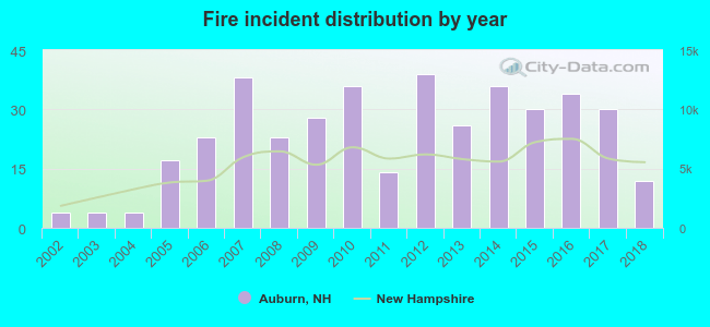 According to the data from the years 2002 - 2018 the average number of fires per year is 23. The highest number of reported fire incidents - 39 took place in 2012, and the least - 4 in 2002. The data has a growing trend.
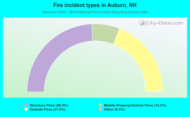 When looking into fire subcategories, the most reports belonged to: Structure Fires (48.5%), and Outside Fires (37.9%).
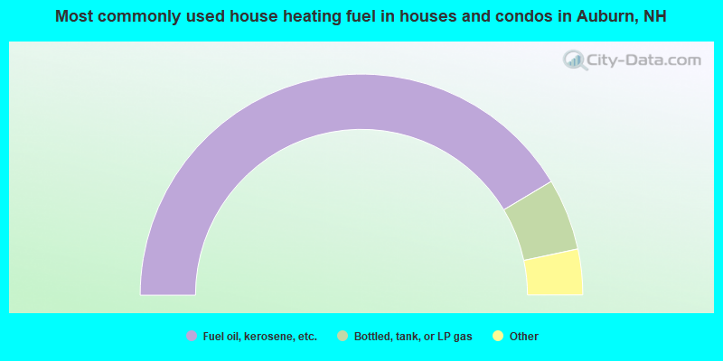
- 82.8%Fuel oil, kerosene, etc.
- 10.5%Bottled, tank, or LP gas
- 3.8%Wood
- 1.4%Coal or coke
- 1.1%Electricity
- 0.5%Solar energy
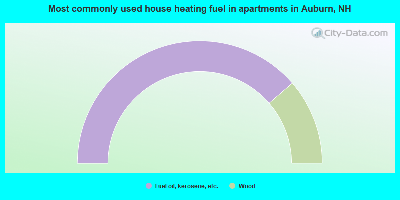
- 77.3%Fuel oil, kerosene, etc.
- 22.7%Wood
Auburn compared to New Hampshire state average:
- Unemployed percentage significantly below state average.
- Black race population percentage significantly below state average.
- Hispanic race population percentage below state average.
- Foreign-born population percentage significantly below state average.
- Renting percentage significantly below state average.
- Length of stay since moving in significantly above state average.
- Number of rooms per house significantly below state average.
- House age significantly below state average.

|
|
Total of 70 patent applications in 2008-2024.