Chesterfield, Massachusetts
Submit your own pictures of this town and show them to the world
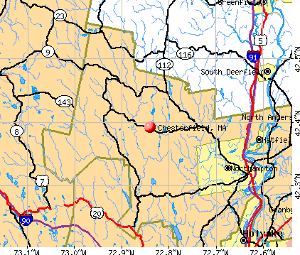
- OSM Map
- General Map
- Google Map
- MSN Map
Population change since 2000: +1.7%
 |
| Males: 623 | |
| Females: 599 |
| Median resident age: | 46.1 years |
| Massachusetts median age: | 39.2 years |
Zip codes: 01012.
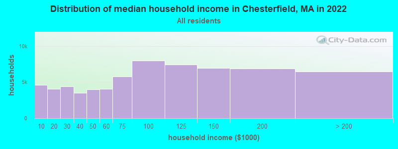
| Chesterfield: | $87,357 |
| MA: | $94,488 |
Estimated per capita income in 2022: $36,867 (it was $19,220 in 2000)
Chesterfield town income, earnings, and wages data
Estimated median house or condo value in 2022: $366,182 (it was $140,900 in 2000)
| Chesterfield: | $366,182 |
| MA: | $534,700 |
Mean prices in 2022: all housing units: $406,762; detached houses: $418,541; townhouses or other attached units: $363,334; in 2-unit structures: $269,911; in 3-to-4-unit structures: $561,325; in 5-or-more-unit structures: $236,751; mobile homes: $362,036
Detailed information about poverty and poor residents in Chesterfield, MA
Compare current foreclosures near Chesterfield, MA:
| Photo | Address | Area | Beds / Baths | Price | Details |
|---|---|---|---|---|---|

|
#1
Cold Spring Rd
Southampton, MA 01073
|
2,736 sq. feet
|
1 baths 3 beds |
$284,900
|
show details |

|
#2
South St
Ashfield, MA 01330
|
4,386 sq. feet
|
3 baths 6 beds |
show details | |

|
#3
Lewandowski Ave
Easthampton, MA 01027
|
1,056 sq. feet
|
1 baths 3 beds |
show details | |

|
#4
Dewey Cir # 5a
Haydenville, MA 01039
|
800 sq. feet
|
2 baths 3 beds |
show details | |

|
#5
Chipman Rd
Middlefield, MA 01243
|
1,486 sq. feet
|
2 baths 2 beds |
show details | |

|
#6
Pleasant St
Holyoke, MA 01040
|
4,057 sq. feet
|
3 baths 6 beds |
show details | |

|
#7
Russell Stage Rd
Blandford, MA 01008
|
1,650 sq. feet
|
2 baths 3 beds |
show details | |

|
#8
Lyman St
South Hadley, MA 01075
|
1,152 sq. feet
|
2 baths 2 beds |
show details | |

|
#9
Loop Rd
Savoy, MA 01256
|
1,040 sq. feet
|
1 baths 3 beds |
show details | |

|
#10
Sunderland Rd
South Deerfield, MA 01373
|
1,385 sq. feet
|
1 baths 3 beds |
show details |
| Photo | Address | Area | Beds / Baths | Price | Details |
|---|---|---|---|---|---|

|
#11
Holyoke St
Easthampton, MA 01027
|
1,106 sq. feet
|
1 baths 2 beds |
show details | |

|
#12
Allyn St
Holyoke, MA 01040
|
1,620 sq. feet
|
1 baths 4 beds |
show details | |

|
#13
Shays St # 1
Amherst, MA 01002
|
925 sq. feet
|
2 baths 3 beds |
show details | |

|
#14
N Main St
South Deerfield, MA 01373
|
2,143 sq. feet
|
1 baths 5 beds |
show details | |

|
#15
W Hawley Rd
Charlemont, MA 01339
|
1,440 sq. feet
|
1 baths 2 beds |
show details | |

|
#16
Kosior Dr
Hadley, MA 01035
|
1,040 sq. feet
|
1 baths 2 beds |
show details | |

|
#17
Chesterfield Rd
Easthampton, MA 01027
|
3,977 sq. feet
|
2 baths 6 beds |
show details | |

|
#18
Sand Hill Rd
Amherst, MA 01002
|
2,037 sq. feet
|
3 baths 5 beds |
show details | |

|
#19
Nonotuck St
Holyoke, MA 01040
|
2,626 sq. feet
|
2 baths 6 beds |
show details | |

|
#20
Plumtree Rd
Sunderland, MA 01375
|
1,536 sq. feet
|
2 baths 2 beds |
show details |
| Photo | Address | Area | Beds / Baths | Price | Details |
|---|---|---|---|---|---|

|
#21
Pine St
South Hadley, MA 01075
|
1,536 sq. feet
|
2 baths 3 beds |
show details | |

|
#22
Dover Rd
South Hadley, MA 01075
|
1,492 sq. feet
|
1 baths 3 beds |
show details | |

|
#23
Central Park Dr
Holyoke, MA 01040
|
2,855 sq. feet
|
2 baths 3 beds |
show details | |

|
#24
Jarvis Ave
Holyoke, MA 01040
|
1,874 sq. feet
|
2 baths 3 beds |
show details | |

|
#25
Priestly Farms Rd
South Hadley, MA 01075
|
3,004 sq. feet
|
3 baths 3 beds |
show details | |

|
#26
Alvord Pl
South Hadley, MA 01075
|
1,358 sq. feet
|
2 baths 2 beds |
show details | |

|
#27
Alvord Pl
South Hadley, MA 01075
|
1,358 sq. feet
|
2 baths 2 beds |
show details | |

|
#28
Woronoco Rd
Blandford, MA 01008
|
2,290 sq. feet
|
2 baths 10 beds |
show details | |

|
#29
Alvord Pl
South Hadley, MA 01075
|
1,358 sq. feet
|
3 baths 3 beds |
show details | |

|
#30
Braeburn Rd
South Deerfield, MA 01373
|
1,661 sq. feet
|
1 baths 3 beds |
show details |
| Photo | Address | Area | Beds / Baths | Price | Details |
|---|---|---|---|---|---|

|
#31
Plum St
Westfield, MA 01085
|
1,440 sq. feet
|
1 baths 3 beds |
show details | |

|
#32
Park St
Easthampton, MA 01027
|
1,064 sq. feet
|
1 baths 2 beds |
show details | |

|
#33
Pine St
Amherst, MA 01002
|
2,195 sq. feet
|
2 baths 4 beds |
show details | |

|
#34
Old North Rd
Worthington, MA 01098
|
2,369 sq. feet
|
3 baths 4 beds |
show details | |

|
#35
Hillside Ave
Holyoke, MA 01040
|
1,540 sq. feet
|
1 baths 3 beds |
show details | |

|
#36
Pershing Ave
South Hadley, MA 01075
|
1,228 sq. feet
|
1 baths 3 beds |
show details | |

|
#37
Cahillane Ter
Florence, MA 01062
|
1,388 sq. feet
|
1 baths 3 beds |
show details | |

|
#38
Brierwood Dr
Florence, MA 01062
|
960 sq. feet
|
1 baths 3 beds |
show details | |

|
#39
Littleville Rd
Huntington, MA 01050
|
1,188 sq. feet
|
1 baths 2 beds |
show details | |

|
#40
David Dr
Hinsdale, MA 01235
|
1,664 sq. feet
|
2 baths 3 beds |
show details |
| Photo | Address | Area | Beds / Baths | Price | Details |
|---|---|---|---|---|---|

|
#41
Glendale Rd
Southampton, MA 01073
|
1,303 sq. feet
|
1 baths 4 beds |
show details | |

|
#42
Chestnut St
West Hatfield, MA 01088
|
1,248 sq. feet
|
1 baths 3 beds |
show details | |

|
#43
Granville St
Holyoke, MA 01040
|
1,374 sq. feet
|
2 baths 3 beds |
show details | |

|
#44
Sabans Rd
Conway, MA 01341
|
1,246 sq. feet
|
1 baths 3 beds |
show details | |

|
#45
Tea St
Charlemont, MA 01339
|
2,829 sq. feet
|
2 baths 6 beds |
show details | |

|
#46
Allman Dr
Chester, MA 01011
|
1,664 sq. feet
|
2 baths 4 beds |
show details | |

|
#47
Myrtle St # 1
Northampton, MA 01060
|
2,222 sq. feet
|
2 baths 4 beds |
show details | |

|
#48
Bridge St # 1
Hatfield, MA 01038
|
3,300 sq. feet
|
3 baths 4 beds |
show details | |

|
#49
Brookline Ave
Holyoke, MA 01040
|
1,512 sq. feet
|
1 baths 4 beds |
show details | |

|
Check over 1 million property listings on Foreclosure.com!
|
browse all offers | |||

- 1,18997.3%White alone
- 181.5%Hispanic
- 70.6%Two or more races
- 50.4%Asian alone
- 10.08%Black alone
- 10.08%American Indian alone
- 10.08%Native Hawaiian and Other
Pacific Islander alone
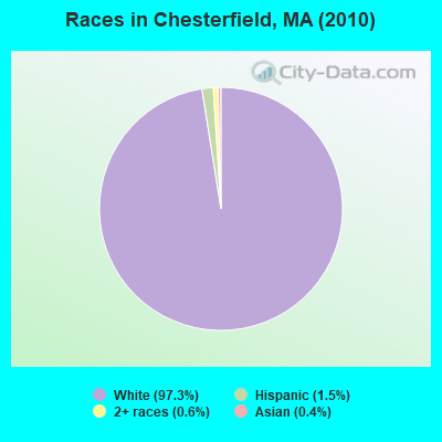
Races in Chesterfield detailed stats: ancestries, foreign born residents, place of birth
According to our research of Massachusetts and other state lists, there was 1 registered sex offender living in Chesterfield, Massachusetts as of April 26, 2024.
The ratio of all residents to sex offenders in Chesterfield is 1,222 to 1.
Type |
2009 |
2011 |
2012 |
2013 |
2017 |
2018 |
2019 |
2020 |
2022 |
|---|---|---|---|---|---|---|---|---|---|
| Murders (per 100,000) | 0 (0.0) | 0 (0.0) | 0 (0.0) | 0 (0.0) | 0 (0.0) | 0 (0.0) | 0 (0.0) | 0 (0.0) | 0 (0.0) |
| Rapes (per 100,000) | 0 (0.0) | 0 (0.0) | 0 (0.0) | 0 (0.0) | 0 (0.0) | 0 (0.0) | 0 (0.0) | 0 (0.0) | 0 (0.0) |
| Robberies (per 100,000) | 0 (0.0) | 0 (0.0) | 0 (0.0) | 0 (0.0) | 0 (0.0) | 0 (0.0) | 0 (0.0) | 0 (0.0) | 0 (0.0) |
| Assaults (per 100,000) | 0 (0.0) | 1 (81.4) | 0 (0.0) | 0 (0.0) | 0 (0.0) | 1 (79.2) | 0 (0.0) | 0 (0.0) | 0 (0.0) |
| Burglaries (per 100,000) | 3 (229.4) | 2 (162.7) | 2 (162.6) | 2 (161.6) | 3 (237.0) | 1 (79.2) | 1 (79.2) | 1 (79.9) | 0 (0.0) |
| Thefts (per 100,000) | 0 (0.0) | 6 (488.2) | 4 (325.2) | 1 (80.8) | 3 (237.0) | 1 (79.2) | 0 (0.0) | 1 (79.9) | 1 (85.2) |
| Auto thefts (per 100,000) | 0 (0.0) | 0 (0.0) | 1 (81.3) | 0 (0.0) | 0 (0.0) | 0 (0.0) | 0 (0.0) | 0 (0.0) | 0 (0.0) |
| Arson (per 100,000) | 0 (0.0) | 0 (0.0) | 0 (0.0) | 0 (0.0) | 0 (0.0) | 0 (0.0) | 0 (0.0) | 0 (0.0) | 0 (0.0) |
| City-Data.com crime index | 16.1 | 47.2 | 30.9 | 14.5 | 26.1 | 24.5 | 5.5 | 8.8 | 3.4 |
The City-Data.com crime index weighs serious crimes and violent crimes more heavily. Higher means more crime, U.S. average is 246.1. It adjusts for the number of visitors and daily workers commuting into cities.
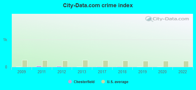
Crime rate in Chesterfield detailed stats: murders, rapes, robberies, assaults, burglaries, thefts, arson
 Recent articles from our blog. Our writers, many of them Ph.D. graduates or candidates, create easy-to-read articles on a wide variety of topics.


 | MA 2022 Question 1 (258 replies) |
| Is it possible to escape hunters, ATVs and noise in a rural area? (278 replies) |
| Republican Primary/local media bias (124 replies) |
| How Much Massachusetts Households Make Per Year: Census Data (37 replies) |
| Is Boston really part of the Northeast Corridor? (111 replies) |
| California to Massachusetts (38 replies) |
Latest news from Chesterfield, MA collected exclusively by city-data.com from local newspapers, TV, and radio stations
Ancestries: Irish (20.5%), English (18.2%), Polish (15.7%), French Canadian (11.3%), French (10.4%), German (10.4%).
Current Local Time: EST time zone
Incorporated in 1762
Elevation: 1427 feet
Land area: 31.1 square miles.
Population density: 39 people per square mile (very low).
19 residents are foreign born
| This town: | 1.6% |
| Massachusetts: | 12.2% |
| Chesterfield town: | 1.7% ($2,376) |
| Massachusetts: | 1.3% ($2,336) |
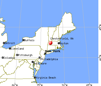
Nearest city with pop. 50,000+: Chicopee, MA  (19.9 miles , pop. 54,653).
Nearest city with pop. 200,000+: Boston, MA (89.3 miles , pop. 589,141).
Nearest city with pop. 1,000,000+: Bronx, NY (119.8 miles , pop. 1,332,650).
Nearest cities:
), ), ), ), ), )Latitude: 42.39 N, Longitude: 72.83 W
Area code: 413

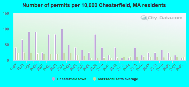
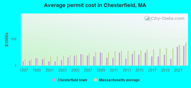
Single-family new house construction building permits:
- 2022: 1 building, cost: $375,000
- 2021: 2 buildings, average cost: $360,500
- 2020: 3 buildings, average cost: $131,700
- 2019: 4 buildings, average cost: $208,000
- 2018: 3 buildings, average cost: $175,000
- 2017: 3 buildings, average cost: $175,000
- 2016: 2 buildings, average cost: $250,000
- 2015: 5 buildings, average cost: $211,300
- 2014: 1 building, cost: $220,000
- 2013: 1 building, cost: $137,300
- 2012: 5 buildings, average cost: $250,000
- 2011: 2 buildings, average cost: $150,000
- 2010: 5 buildings, average cost: $153,000
- 2009: 10 buildings, average cost: $257,000
- 2008: 3 buildings, average cost: $175,000
- 2007: 4 buildings, average cost: $194,000
- 2006: 5 buildings, average cost: $218,600
- 2005: 6 buildings, average cost: $192,800
- 2004: 12 buildings, average cost: $158,300
- 2003: 10 buildings, average cost: $109,200
- 2002: 10 buildings, average cost: $85,000
- 2001: 3 buildings, average cost: $84,700
- 2000: 11 buildings, average cost: $126,900
- 1999: 11 buildings, average cost: $143,200
- 1998: 8 buildings, average cost: $98,300
- 1997: 5 buildings, average cost: $86,400
| Here: | 2.7% |
| Massachusetts: | 3.5% |
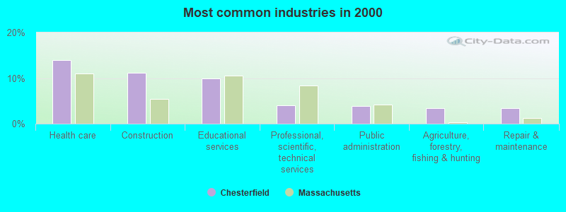
- Health care (13.9%)
- Construction (11.1%)
- Educational services (9.9%)
- Professional, scientific, technical services (4.1%)
- Public administration (3.8%)
- Agriculture, forestry, fishing & hunting (3.4%)
- Repair & maintenance (3.4%)
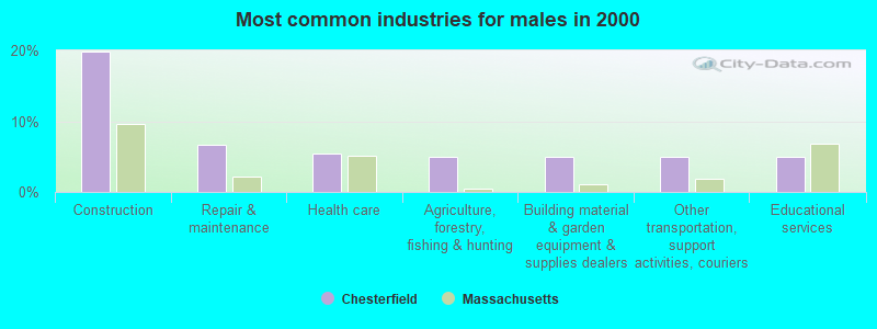
- Construction (19.9%)
- Repair & maintenance (6.6%)
- Health care (5.5%)
- Agriculture, forestry, fishing & hunting (4.9%)
- Building material & garden equipment & supplies dealers (4.9%)
- Other transportation, support activities, couriers (4.9%)
- Educational services (4.9%)
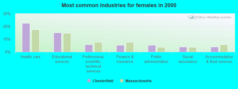
- Health care (22.6%)
- Educational services (15.1%)
- Professional, scientific, technical services (5.9%)
- Finance & insurance (5.3%)
- Public administration (5.3%)
- Social assistance (3.9%)
- Accommodation & food services (3.9%)

- Registered nurses (4.5%)
- Other management occupations, except farmers and farm managers (3.8%)
- Electrical equipment mechanics and other installation, maintenance, and repair workers, including supervisors (3.8%)
- Metal workers and plastic workers (3.7%)
- Material recording, scheduling, dispatching, and distributing workers (3.7%)
- Driver/sales workers and truck drivers (3.4%)
- Customer service representatives (3.4%)
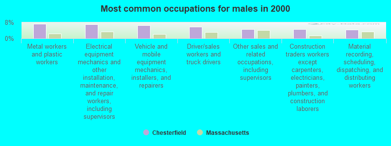
- Metal workers and plastic workers (7.2%)
- Electrical equipment mechanics and other installation, maintenance, and repair workers, including supervisors (6.9%)
- Vehicle and mobile equipment mechanics, installers, and repairers (6.6%)
- Driver/sales workers and truck drivers (5.8%)
- Other sales and related occupations, including supervisors (4.6%)
- Construction traders workers except carpenters, electricians, painters, plumbers, and construction laborers (4.6%)
- Material recording, scheduling, dispatching, and distributing workers (4.3%)

- Registered nurses (8.3%)
- Customer service representatives (5.9%)
- Health technologists and technicians (5.3%)
- Other management occupations, except farmers and farm managers (4.7%)
- Information and record clerks, except customer service representatives (3.9%)
- Counselors, social workers, and other community and social service specialists (3.9%)
- Preschool, kindergarten, elementary, and middle school teachers (3.3%)
Average climate in Chesterfield, Massachusetts
Based on data reported by over 4,000 weather stations


(lower is better)
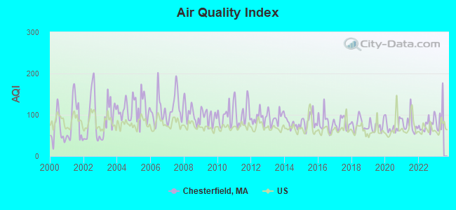
Air Quality Index (AQI) level in 2022 was 75.1. This is about average.
| City: | 75.1 |
| U.S.: | 72.6 |
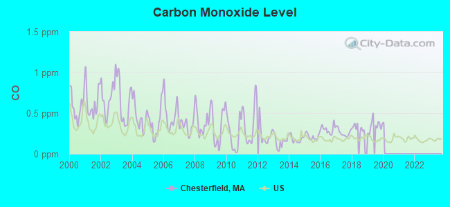
Carbon Monoxide (CO) [ppm] level in 2019 was 0.346. This is worse than average. Closest monitor was 18.5 miles away from the city center.
| City: | 0.346 |
| U.S.: | 0.251 |
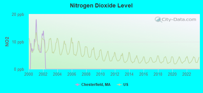
Nitrogen Dioxide (NO2) [ppb] level in 2001 was 9.83. This is significantly worse than average. Closest monitor was 17.2 miles away from the city center.
| City: | 9.83 |
| U.S.: | 5.11 |
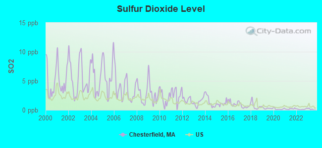
Sulfur Dioxide (SO2) [ppb] level in 2022 was 0.141. This is significantly better than average. Closest monitor was 12.9 miles away from the city center.
| City: | 0.141 |
| U.S.: | 1.515 |
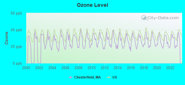
Ozone [ppb] level in 2022 was 26.4. This is better than average. Closest monitor was 15.8 miles away from the city center.
| City: | 26.4 |
| U.S.: | 33.3 |
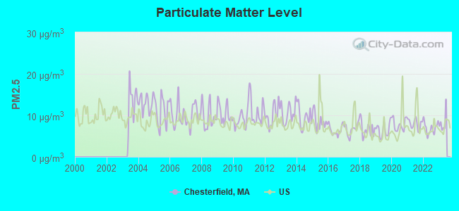
Particulate Matter (PM2.5) [µg/m3] level in 2022 was 6.94. This is about average. Closest monitor was 18.9 miles away from the city center.
| City: | 6.94 |
| U.S.: | 8.11 |
Tornado activity:
Chesterfield-area historical tornado activity is above Massachusetts state average. It is 11% smaller than the overall U.S. average.
On 5/29/1995, a category F4 (max. wind speeds 207-260 mph) tornado 23.2 miles away from the Chesterfield town center killed 3 people and injured 24 people and caused between $5,000,000 and $50,000,000 in damages.
On 10/3/1979, a category F4 tornado 24.8 miles away from the town center killed 3 people and injured 500 people and caused between $50,000,000 and $500,000,000 in damages.
Earthquake activity:
Chesterfield-area historical earthquake activity is significantly above Massachusetts state average. It is 69% smaller than the overall U.S. average.On 10/7/1983 at 10:18:46, a magnitude 5.3 (5.1 MB, 5.3 LG, 5.1 ML, Class: Moderate, Intensity: VI - VII) earthquake occurred 131.9 miles away from the city center
On 4/20/2002 at 10:50:47, a magnitude 5.3 (5.3 ML, Depth: 3.0 mi) earthquake occurred 152.8 miles away from the city center
On 4/20/2002 at 10:50:47, a magnitude 5.2 (5.2 MB, 4.2 MS, 5.2 MW, 5.0 MW) earthquake occurred 151.4 miles away from the city center
On 1/19/1982 at 00:14:42, a magnitude 4.7 (4.5 MB, 4.7 MD, 4.5 LG, Class: Light, Intensity: IV - V) earthquake occurred 98.7 miles away from the city center
On 10/16/2012 at 23:12:25, a magnitude 4.7 (4.7 ML, Depth: 10.0 mi) earthquake occurred 138.0 miles away from Chesterfield center
On 6/17/1991 at 08:53:16, a magnitude 4.1 (4.0 MB, 4.0 LG, Depth: 3.1 mi) earthquake occurred 95.5 miles away from Chesterfield center
Magnitude types: regional Lg-wave magnitude (LG), body-wave magnitude (MB), duration magnitude (MD), local magnitude (ML), surface-wave magnitude (MS), moment magnitude (MW)
Natural disasters:
The number of natural disasters in Hampshire County (21) is greater than the US average (15).Major Disasters (Presidential) Declared: 10
Emergencies Declared: 10
Causes of natural disasters: Floods: 5, Snowstorms: 5, Storms: 5, Hurricanes: 4, Winter Storms: 4, Blizzards: 2, Snows: 2, Snowfall: 1, Tropical Storm: 1, Wind: 1, Other: 1 (Note: some incidents may be assigned to more than one category).

Hospitals and medical centers near Chesterfield:
- OVERLOOK AT NORTHAMPTON (Nursing Home, about 7 miles away; LEEDS, MA)
- LINDA MANOR EXTENDED CARE FACILITY (Nursing Home, about 8 miles away; LEEDS, MA)
- NORTHAMPTON VA MEDICAL CENTER (Hospital, Acute Care - Veterans Administration, about 9 miles away; LEEDS, MA)
- COOLEY DICKINSON HOSPITAL INC,THE Acute Care Hospitals (about 11 miles away; NORTHAMPTON, MA)
- CALVIN COOLIDGE NURING AND REHAB CTR - NORTHAMPTON (Nursing Home, about 11 miles away; NORTHAMPTON, MA)
- NORTHAMPTON REHABILITATION AND NURSING CENTER (Nursing Home, about 11 miles away; NORTHAMPTON, MA)
- SERVICENET HOMECARE (Home Health Center, about 11 miles away; NORTHAMPTON, MA)
Colleges/universities with over 2000 students nearest to Chesterfield:
- Smith College (about 12 miles; Northampton, MA; Full-time enrollment: 3,549)
- University of Massachusetts-Amherst (about 16 miles; Amherst, MA; FT enrollment: 26,583)
- Mount Holyoke College (about 17 miles; South Hadley, MA; FT enrollment: 2,573)
- Holyoke Community College (about 17 miles; Holyoke, MA; FT enrollment: 4,911)
- Westfield State University (about 19 miles; Westfield, MA; FT enrollment: 5,548)
- Springfield Technical Community College (about 24 miles; Springfield, MA; FT enrollment: 4,750)
- American International College (about 25 miles; Springfield, MA; FT enrollment: 2,733)
Public elementary/middle school in Chesterfield:
- NEW HINGHAM REGIONAL ELEMENTARY (Students: 172, Location: 30 SMITH RD, Grades: PK-6)
Points of interest:
Notable locations in Chesterfield: Ireland Street Orchard (A), Chesterfield Fire Department Station 1 Headquarters (B), Chesterfield Town Hall (C). Display/hide their locations on the map
Cemeteries: Gate Cemetery (1), Mount Cemetery (2), Bofat Cemetery (3), Damon Cemetery (4), Torrey Cemetery (5), Ireland Street Cemetery (6). Display/hide their locations on the map
Lakes, reservoirs, and swamps: Scout Pond (A), Long Pond (B), Damon Pond (C), Wilder Swamp (D), Dead Swamp (E). Display/hide their locations on the map
Streams, rivers, and creeks: Jewel Brook (A), Dresser Brook (B), Thayer Brook (C), Chauncey Brook (D), Holly Brook (E), Baker Brook (F), Whiteside Brook (G), Tower Brook (H), West Branch (I). Display/hide their locations on the map
Birthplace of: Elijah H. Mills - Politician, William Henry Anderson - Entomologist.
| This town: | 2.4 people |
| Massachusetts: | 2.5 people |
| This town: | 68.9% |
| Whole state: | 63.0% |
| This town: | 10.2% |
| Whole state: | 7.0% |
Likely homosexual households (counted as self-reported same-sex unmarried-partner households)
- Lesbian couples: 1.4% of all households
- Gay men: 0.0% of all households
| This town: | 5.7% |
| Whole state: | 9.3% |
| This town: | 2.8% |
| Whole state: | 4.4% |
For population 15 years and over in Chesterfield:
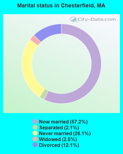
- Never married: 26.1%
- Now married: 57.2%
- Separated: 2.1%
- Widowed: 2.5%
- Divorced: 12.1%
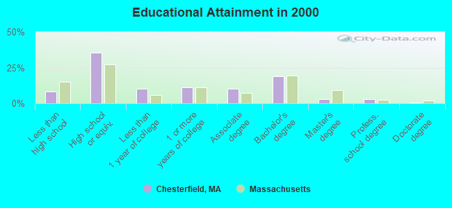
For population 25 years and over in Chesterfield:
- High school or higher: 91.6%
- Bachelor's degree or higher: 24.9%
- Graduate or professional degree: 6.2%
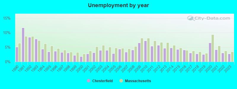
- Unemployed: 3.5%
- Mean travel time to work (commute): 29.4 minutes
| Here: | 9.7 |
| Massachusetts average: | 13.1 |
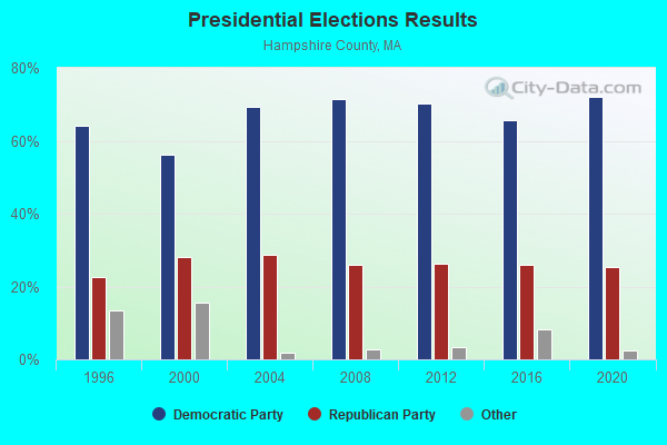
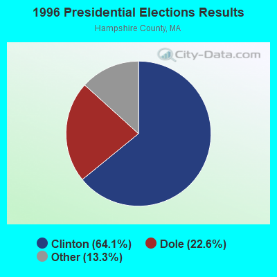
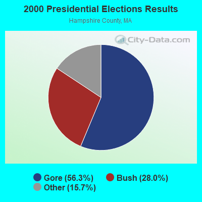
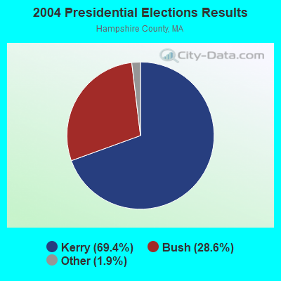
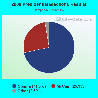
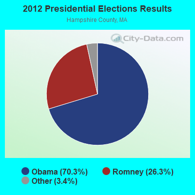
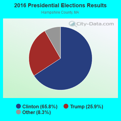
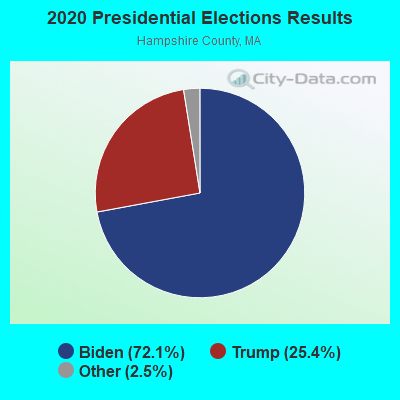
Graphs represent county-level data. Detailed 2008 Election Results
Religion statistics for Chesterfield, MA (based on Hampshire County data)
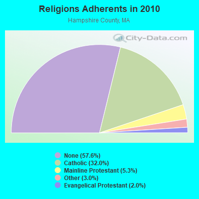
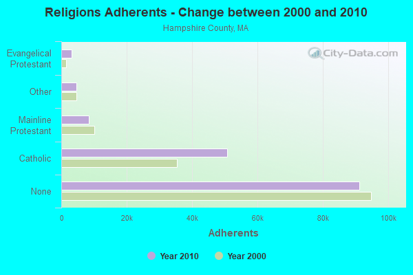
| Religion | Adherents | Congregations |
|---|---|---|
| Catholic | 50,643 | 22 |
| Mainline Protestant | 8,454 | 45 |
| Other | 4,722 | 27 |
| Evangelical Protestant | 3,128 | 22 |
| Black Protestant | 29 | 1 |
| None | 91,104 | - |
Food Environment Statistics:
| Here: | 2.07 / 10,000 pop. |
| State: | 1.98 / 10,000 pop. |
| Hampshire County: | 0.06 / 10,000 pop. |
| State: | 0.05 / 10,000 pop. |
| Hampshire County: | 1.55 / 10,000 pop. |
| Massachusetts: | 2.22 / 10,000 pop. |
| This county: | 1.94 / 10,000 pop. |
| Massachusetts: | 1.77 / 10,000 pop. |
| Here: | 10.22 / 10,000 pop. |
| Massachusetts: | 8.76 / 10,000 pop. |
| Hampshire County: | 7.3% |
| Massachusetts: | 8.1% |
| This county: | 21.7% |
| Massachusetts: | 22.5% |
| Here: | 12.3% |
| Massachusetts: | 16.5% |
Strongest AM radio stations in Chesterfield:
- WNNZ (640 AM; 50 kW; WESTFIELD, MA; Owner: CLEAR CHANNEL BROADCASTING LICENSES, INC.)
- WHYN (560 AM; 5 kW; SPRINGFIELD, MA; Owner: CLEAR CHANNEL BROADCASTING LICENSES, INC.)
- WCRN (830 AM; 50 kW; WORCESTER, MA; Owner: CARTER BROADCASTING CORPORATION)
- WTIC (1080 AM; 50 kW; HARTFORD, CT; Owner: INFINITY RADIO OPERATIONS INC.)
- WVNE (760 AM; daytime; 25 kW; LEICESTER, MA; Owner: BLOUNT MASSCOM, INC.)
- WIZZ (1520 AM; daytime; 10 kW; GREENFIELD, MA; Owner: P. & M. RADIO, LLC)
- WACE (730 AM; 5 kW; CHICOPEE, MA; Owner: CARTER BROADCASTING CORP.)
- WGY (810 AM; 50 kW; SCHENECTADY, NY; Owner: CLEAR CHANNEL BROADCASTING LICENSES, INC.)
- WPNI (1430 AM; 5 kW; AMHERST, MA; Owner: WESTERN MASSACHUSETTS RADIO COMPANY)
- WRKO (680 AM; 50 kW; BOSTON, MA; Owner: ENTERCOM BOSTON LICENSE, LLC)
- WALE (990 AM; 50 kW; GREENVILLE, RI; Owner: NORTH AMERICAN BROADCASTING CO., INC.)
- WPTR (1540 AM; 50 kW; ALBANY, NY; Owner: KIMTRON, INC.)
- WEEI (850 AM; 50 kW; BOSTON, MA; Owner: ENTERCOM BOSTON LICENSE, LLC)
Strongest FM radio stations in Chesterfield:
- WHYN-FM (93.1 FM; SPRINGFIELD, MA; Owner: CLEAR CHANNEL BROADCASTING LICENSES, INC.)
- WAMC-FM (90.3 FM; ALBANY, NY; Owner: WAMC)
- WRNX (100.9 FM; AMHERST, MA; Owner: WESTERN MASSACHUSETTS RADIO COMPANY)
- WLZX (99.3 FM; NORTHAMPTON, MA; Owner: SAGA COMMUNICATIONS OF NEW ENGLAND, LLC)
- WEIB (106.3 FM; NORTHAMPTON, MA; Owner: CUTTING EDGE BROADCASTING, INC.)
- WFCR (88.5 FM; AMHERST, MA; Owner: UNIVERSITY OF MASSACHUSETTS)
- WAMH (89.3 FM; AMHERST, MA; Owner: TRUSTEES OF AMHERST COLLEGE)
- WAQY (102.1 FM; SPRINGFIELD, MA; Owner: SAGA COMMUNICATIONS OF NEW ENGLAND, LLC)
- WEQX (102.7 FM; MANCHESTER, VT; Owner: NORTHSHIRE COMMUNICATIONS, INC.)
- WJAN (95.1 FM; SUNDERLAND, VT; Owner: 6 JOHNSON ROAD LICENSES, INC.)
- WPVQ (95.3 FM; GREENFIELD, MA; Owner: GREAT NORTHERN RADIO, L.L.C.)
- W246AM (97.1 FM; AMHERST, MA; Owner: GREAT NORTHERN RADIO, LLC)
- WVAY (100.7 FM; WILMINGTON, VT; Owner: GREAT NORTHERN RADIO, L.L.C.)
- WHAI (98.3 FM; GREENFIELD, MA; Owner: SAGA COMMUNICATIONS OF NEW ENGLAND, LLC)
- WRSI (93.9 FM; TURNERS FALLS, MA; Owner: GREAT NORTHERN RADIO, LLC)
- WHVP (91.1 FM; HUDSON, NY; Owner: SOUND OF LIFE, INC.)
- WBEC-FM (105.5 FM; PITTSFIELD, MA; Owner: GREAT NORTHERN RADIO, LLC)
- WZEC (97.5 FM; HOOSICK FALLS, NY; Owner: GREAT NORTHERN RADIO, LLC)
- WUPE (95.9 FM; PITTSFIELD, MA; Owner: WEINER BROADCASTING, INC.)
- WPKX (97.9 FM; ENFIELD, CT; Owner: CAPSTAR TX LIMITED PARTNERSHIP)
TV broadcast stations around Chesterfield:
- W35BK (Channel 35; PLAINFIELD, MA; Owner: LYDIA SYLVANE STOCKWELL)
- WYDN (Channel 48; WORCESTER, MA; Owner: EDUCATIONAL PUBLIC TV CORPORATION)
- WTIC-TV (Channel 61; HARTFORD, CT; Owner: TRIBUNE TELEVISION COMPANY)
- W11BJ (Channel 11; HARTFORD, CT; Owner: COMMUNICATIONS SITE MANAGEMENT LLC)
- WWLP (Channel 22; SPRINGFIELD, MA; Owner: WWLP BROADCASTING, LLC)
- WTXX (Channel 20; WATERBURY, CT; Owner: WTXX INC.)
- WUVN (Channel 18; HARTFORD, CT; Owner: ENTRAVISION HOLDINGS, LLC)
- W67DF (Channel 67; SPRINGFIELD, MA; Owner: TRINITY BROADCASTING NETWORK)
- WGGB-TV (Channel 40; SPRINGFIELD, MA; Owner: WGGB LICENSEE, LLC)
- WGBY-TV (Channel 57; SPRINGFIELD, MA; Owner: WGBH EDUCATIONAL FOUNDATION)
- Chesterfield, Massachusetts
- Fatal accident count8
- Vehicles involved in fatal accidents8
- Fatal accidents involving drunk persons:3
- Fatalities10
- Persons involved in fatal accidents11
- Pedestrians involved in fatal accidents0
- Massachusetts average
- Fatal accident count4713
- Vehicles involved in fatal accidents6529
- Fatal accidents involving drunk persons1312
- Fatalities5092
- Persons involved in fatal accidents10912
- Pedestrians involved in fatal accidents414
- National Bridge Inventory (NBI) Statistics
- 10Number of bridges
- 62ft / 18.7mTotal length
- $10,892,000Total costs
- 13,688Total average daily traffic
- 859Total average daily truck traffic
- 8,387Total future (year 2031) average daily traffic
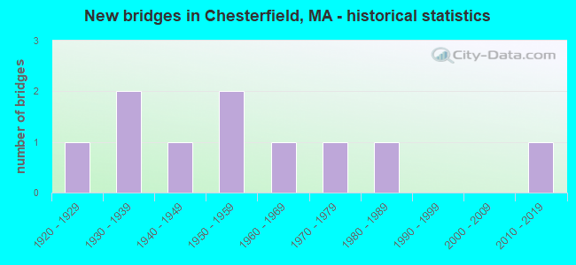
- New bridges - historical statistics
- 11920-1929
- 21930-1939
- 11940-1949
- 21950-1959
- 11960-1969
- 11970-1979
- 11980-1989
- 12010-2019
FCC Registered Antenna Towers:
4- Dawn L Keniley, 33 Ireland St. Extension / Us- Ma-5046 (Lat: 42.343750 Lon: -72.879389), Type: 42.7, Structure height: 25015 m, Overall height: 39.6 m, Registrant: Vertical Bridge Development, LLC, Fcc-Faa@verticalbridge.Com, Suite 200, Boca -Raton, Phone: (561) 406-4015
- Dawn L Keniley, 33 Ireland St. Extension / Us- Ma-5046 (Lat: 42.343750 Lon: -72.879389), Type: 42.7, Structure height: 25015 m, Overall height: 39.6 m, Registrant: Vertical Bridge Development, LLC, Fcc-Faa@verticalbridge.Com, Suite 200, Boca -Raton, Phone: (561) 406-4015
- Dawn L Keniley, 33 Ireland St. Extension / Us- Ma-5046 (Lat: 42.343750 Lon: -72.879389), Type: 42.7, Structure height: 25015 m, Overall height: 39.6 m, Registrant: Vertical Bridge Development, LLC, Fcc-Faa@verticalbridge.Com, Suite 200, Boca -Raton, Phone: (561) 406-4015
- Donna Kellison, 33 Ireland St. Extension / Us- Ma-5046 (Lat: 42.343750 Lon: -72.879389), Type: 42.7, Structure height: 25015 m, Overall height: 39.6 m, Registrant: Vb Bts, LLC, Fccsecuritization@verticalbridge.Com, Suite 200, Boca -Raton, Phone: (561) 406-4015
FCC Registered Private Land Mobile Towers:
1- Munson Rd (Lat: 42.360083 Lon: -72.798972), Type: Tower, Structure height: 56 m, Call Sign: WPKD793,
Assigned Frequencies: 929.062 MHz, Grant Date: 01/27/1997, Expiration Date: 01/27/2002, Cancellation Date: 09/18/2000, Certifier: Alan Capewell, Registrant: Trott Communications Group Inc, 1425 Greenway Dr Ste 350, Irving, TX 75038, Fax: (214) 580-0641
FCC Registered Broadcast Land Mobile Towers:
2- FIRE STATION, 5 North Rd (Lat: 42.392500 Lon: -72.841250), Type: Bant, Structure height: 11 m, Overall height: 12 m, Call Sign: KCH620,
Assigned Frequencies: 154.370 MHz, Grant Date: 04/13/2022, Expiration Date: 05/05/2032, Registrant: Battenburg Usa Inc, Warren, MA 01083-0637, Phone: (877) 267-7291, Email:
- HIGHWAY GARAGE, 164 Main Rd (Lat: 42.384833 Lon: -72.803111), Type: Bant, Structure height: 11 m, Overall height: 12 m, Call Sign: KNAG226,
Assigned Frequencies: 154.115 MHz, Grant Date: 12/15/2020, Expiration Date: 03/14/2031, Registrant: Battenburg Usa Inc, Warren, MA 01083-0637, Phone: (877) 267-7291, Email:
FCC Registered Microwave Towers:
1- SBA-MA07275, 53 Bofat Hill Road (Lat: 42.361194 Lon: -72.798806), Type: Mast, Structure height: 55.2 m, Call Sign: WQZU686,
Assigned Frequencies: 10875.0 MHz, 6775.00 MHz, 10875.0 MHz, 6775.00 MHz, 10875.0 MHz, 6775.00 MHz, 10875.0 MHz, 6775.00 MHz, 10875.0 MHz, 6775.00 MHz... (+6 more), Grant Date: 08/08/2017, Expiration Date: 08/08/2027, Certifier: Nilsa Brown, Registrant: L3harris Technologies, Inc., 1025 West Nasa Boulevard, Ms F-11 A, Melbourne, FL 32919, Phone: (321) 309-2452, Fax: (321) 726-3336, Email:
FCC Registered Amateur Radio Licenses:
14 (See the full list of FCC Registered Amateur Radio Licenses in Chesterfield)2002 - 2018 National Fire Incident Reporting System (NFIRS) incidents
- Fire incident types reported to NFIRS in Chesterfield, MA
- 6550.4%Structure Fires
- 4736.4%Outside Fires
- 118.5%Other
- 64.7%Mobile Property/Vehicle Fires
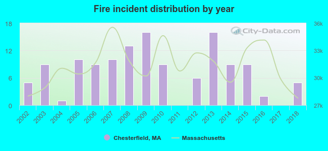 According to the data from the years 2002 - 2018 the average number of fire incidents per year is 8. The highest number of fire incidents - 16 took place in 2009, and the least - 0 in 2011. The data has a constant trend.
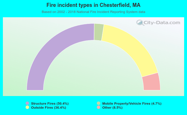 When looking into fire subcategories, the most incidents belonged to: Structure Fires (50.4%), and Outside Fires (36.4%).
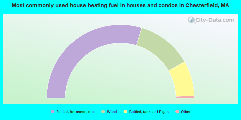
- 59.3%Fuel oil, kerosene, etc.
- 24.2%Wood
- 15.5%Bottled, tank, or LP gas
- 0.5%Electricity
- 0.5%No fuel used
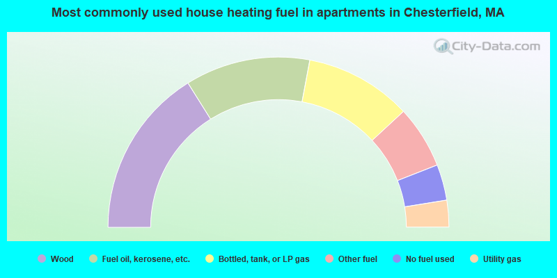
- 32.2%Wood
- 23.7%Fuel oil, kerosene, etc.
- 20.3%Bottled, tank, or LP gas
- 11.9%Other fuel
- 6.8%No fuel used
- 5.1%Utility gas
Chesterfield compared to Massachusetts state average:
- Unemployed percentage significantly below state average.
- Black race population percentage significantly below state average.
- Hispanic race population percentage significantly below state average.
- Median age above state average.
- Foreign-born population percentage significantly below state average.
- Renting percentage significantly below state average.
- Length of stay since moving in significantly above state average.
- Number of rooms per house significantly below state average.
- House age significantly below state average.

|
|
Total of 21 patent applications in 2008-2024.