Dairyland, Wisconsin
Submit your own pictures of this town and show them to the world
- OSM Map
- General Map
- Google Map
- MSN Map

Population change since 2000: -1.1%
| Males: 97 | |
| Females: 87 |
| Median resident age: | 49.9 years |
| Wisconsin median age: | 42.6 years |
Zip code: 54830
| Dairyland: | $63,533 |
| WI: | $70,996 |
Estimated per capita income in 2022: $36,744 (it was $18,155 in 2000)
Estimated median house or condo value in 2022: $123,065 (it was $45,600 in 2000)
| Dairyland: | $123,065 |
| WI: | $252,800 |
Mean prices in 2022: all housing units: $201,945; detached houses: $209,055; townhouses or other attached units: $212,805; in 2-unit structures: $185,551; mobile homes: $81,636; occupied boats, rvs, vans, etc.: $123,010
Detailed information about poverty and poor residents in Dairyland, WI


- 18298.9%White alone
- 10.5%Black alone
- 10.5%American Indian alone

According to our research of Wisconsin and other state lists, there were 2 registered sex offenders living in Dairyland, Wisconsin as of May 02, 2024.
The ratio of all residents to sex offenders in Dairyland is 92 to 1.
 Recent articles from our blog. Our writers, many of them Ph.D. graduates or candidates, create easy-to-read articles on a wide variety of topics.


 | Wisconsin Ranked as 11th Best State to Live (69 replies) |
| Moving from Omaha to Madison (5 replies) |
| America's Dairyland? (30 replies) |
| What comes to mind when you think of Milwaukee? (206 replies) |
| Supper Clubs in NW Wi. (26 replies) |
| Milwaukee is not a suburb of Chicago (86 replies) |
Latest news from Dairyland, WI collected exclusively by city-data.com from local newspapers, TV, and radio stations
Ancestries: German (35.5%), Swedish (16.1%), Norwegian (14.0%), United States (11.3%), Irish (8.6%), English (7.5%).
Current Local Time: CST time zone
Elevation: 1122 feet
Land area: 140.2 square miles.
Population density: 1.3 people per square mile (very low).

| Dairyland town: | 0.6% ($267) |
| Wisconsin: | 2.0% ($2,245) |
Nearest city with pop. 50,000+: Duluth, MN  (38.2 miles , pop. 86,918).
Nearest city with pop. 200,000+: St. Paul, MN (99.0 miles , pop. 287,151).
Nearest city with pop. 1,000,000+: Chicago, IL (377.1 miles , pop. 2,896,016).
Nearest cities:
), ), ), ), ), Latitude: 46.23 N, Longitude: 92.18 W
Area code: 715


| Here: | 3.9% |
| Wisconsin: | 2.7% |

- Health care (12.6%)
- Accommodation & food services (11.6%)
- Public administration (10.5%)
- Educational services (7.4%)
- Food (6.3%)
- U. S. Postal service (6.3%)
- Wood products (5.3%)

- Public administration (14.0%)
- U. S. Postal service (10.5%)
- Wood products (8.8%)
- Utilities (8.8%)
- Truck transportation (7.0%)
- Farm product raw materials merchant wholesalers (7.0%)
- Arts, entertainment, recreation (7.0%)

- Health care (26.3%)
- Accommodation & food services (21.1%)
- Educational services (13.2%)
- Food (10.5%)
- Professional, scientific, technical services (7.9%)
- Building material & garden equipment & supplies dealers (5.3%)
- Public administration (5.3%)

- Registered nurses (7.4%)
- Driver/sales workers and truck drivers (7.4%)
- Metal workers and plastic workers (6.3%)
- Other production occupations, including supervisors (6.3%)
- Other office and administrative support workers, including supervisors (5.3%)
- Electrical equipment mechanics and other installation, maintenance, and repair workers, including supervisors (4.2%)
- Law enforcement workers, including supervisors (4.2%)

- Driver/sales workers and truck drivers (12.3%)
- Metal workers and plastic workers (10.5%)
- Law enforcement workers, including supervisors (7.0%)
- Electrical equipment mechanics and other installation, maintenance, and repair workers, including supervisors (7.0%)
- Other production occupations, including supervisors (7.0%)
- Building and grounds cleaning and maintenance occupations (5.3%)
- Material recording, scheduling, dispatching, and distributing workers (5.3%)

- Registered nurses (18.4%)
- Cooks and food preparation workers (10.5%)
- Waiters and waitresses (10.5%)
- Preschool, kindergarten, elementary, and middle school teachers (7.9%)
- Other health diagnosing and treating practitioners and technical occupations (7.9%)
- Supervisors and other personal care and service workers, except child care workers (7.9%)
- Teachers, secondary school (5.3%)
Average climate in Dairyland, Wisconsin
Based on data reported by over 4,000 weather stations


Tornado activity:
Dairyland-area historical tornado activity is significantly below Wisconsin state average. It is 54% smaller than the overall U.S. average.
On 6/18/2001, a category F3 (max. wind speeds 158-206 mph) tornado 29.5 miles away from the Dairyland town center killed 2 people and injured 16 people and caused $10 million in damages.
On 5/21/1957, a category F4 (max. wind speeds 207-260 mph) tornado 48.3 miles away from the town center injured 2 people and caused between $5000 and $50,000 in damages.
Earthquake activity:
Dairyland-area historical earthquake activity is significantly above Wisconsin state average. It is 64% smaller than the overall U.S. average.On 7/9/1975 at 14:54:15, a magnitude 4.6 (4.6 MB, Class: Light, Intensity: IV - V) earthquake occurred 189.5 miles away from the city center
On 6/5/1993 at 01:24:53, a magnitude 4.1 (4.1 LG, Depth: 6.2 mi) earthquake occurred 201.3 miles away from Dairyland center
On 2/7/2020 at 18:30:28, a magnitude 3.3 (3.3 ML, Class: Light, Intensity: II - III) earthquake occurred 90.1 miles away from the city center
On 1/9/2020 at 18:16:48, a magnitude 3.3 (3.3 MB) earthquake occurred 94.2 miles away from the city center
On 4/8/2020 at 17:14:33, a magnitude 3.3 (3.3 ML) earthquake occurred 95.1 miles away from Dairyland center
On 4/21/2020 at 17:12:46, a magnitude 3.2 (3.2 ML) earthquake occurred 92.4 miles away from Dairyland center
Magnitude types: regional Lg-wave magnitude (LG), body-wave magnitude (MB), local magnitude (ML)
Natural disasters:
The number of natural disasters in Douglas County (9) is smaller than the US average (15).Major Disasters (Presidential) Declared: 7
Emergencies Declared: 2
Causes of natural disasters: Floods: 6, Storms: 4, Winds: 2, Drought: 1, Heavy Rain: 1, Hurricane: 1, Other: 1 (Note: some incidents may be assigned to more than one category).

Colleges/universities with over 2000 students nearest to Dairyland:
- University of Wisconsin-Superior (about 35 miles; Superior, WI; Full-time enrollment: 2,302)
- Wisconsin Indianhead Technical College (about 36 miles; Shell Lake, WI; FT enrollment: 2,414)
- Lake Superior College (about 39 miles; Duluth, MN; FT enrollment: 3,768)
- The College of Saint Scholastica (about 41 miles; Duluth, MN; FT enrollment: 3,762)
- University of Minnesota-Duluth (about 42 miles; Duluth, MN; FT enrollment: 10,612)
- Century College (about 91 miles; White Bear Lake, MN; FT enrollment: 7,393)
- Anoka-Ramsey Community College (about 93 miles; Coon Rapids, MN; FT enrollment: 5,918)
Points of interest:
Notable locations in Dairyland: Dairyland Volunteer Fire and Rescue Station 2 (A), Dairyland Volunteer Fire and Rescue Station 1 (B), Dairyland Townhall (C). Display/hide their locations on the map
Churches in Dairyland include: Saint Jude Church (A), Covenant Church (B). Display/hide their locations on the map
Cemeteries: Dairyland Cemetery (1), Riverhill Cemetery (2). Display/hide their locations on the map
Reservoirs and swamps: Radigan Flowage 41 (A), Empire Swamp (B), Radigan Flowage (C). Display/hide their locations on the map
Streams, rivers, and creeks: Beaver Creek (A), Bacon Creek (B), Thompson Creek (C), Toad Creek (D), Spruce River (E), Rock Creek (F), Boyles Brook (G), Dingle Creek (H). Display/hide their locations on the map
Parks in Dairyland include: Schoen Park (1), Louise Park (2). Display/hide their locations on the map
Drinking water stations with addresses in Dairyland and their reported violations in the past:
MOOSE JUNCTION BAR (Population served: 25, Groundwater):Past monitoring violations:
- Monitoring, Repeat Major (TCR) - Between JAN-2006 and DEC-2006, Contaminant: Coliform (TCR). Follow-up actions: St Public Notif received (JUN-16-2006), St Other (OCT-10-2006), St Compliance achieved (2 times from FEB-20-2007 to SEP-11-2011)
- One routine major monitoring violation
| This town: | 2.2 people |
| Wisconsin: | 2.4 people |
| This town: | 67.5% |
| Whole state: | 64.4% |
| This town: | 7.2% |
| Whole state: | 7.3% |
Likely homosexual households (counted as self-reported same-sex unmarried-partner households)
- Lesbian couples: 1.2% of all households
- Gay men: 1.2% of all households
| This town: | 9.0% |
| Whole state: | 8.7% |
| This town: | 3.5% |
| Whole state: | 3.7% |
For population 15 years and over in Dairyland:

- Never married: 17.8%
- Now married: 63.2%
- Separated: 1.6%
- Widowed: 9.7%
- Divorced: 7.6%
For population 25 years and over in Dairyland:
- High school or higher: 74.3%
- Bachelor's degree or higher: 12.0%
- Graduate or professional degree: 2.9%
- Unemployed: 6.9%
- Mean travel time to work (commute): 39.8 minutes


| Here: | 12.3 |
| Wisconsin average: | 11.0 |
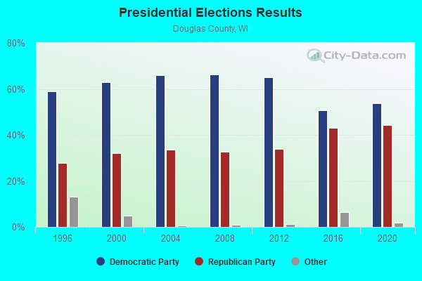
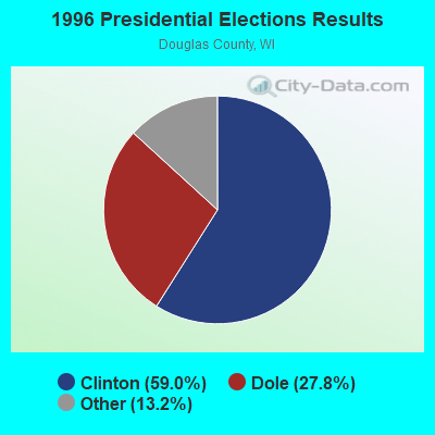
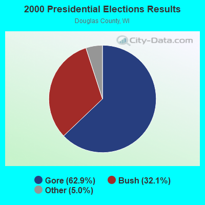

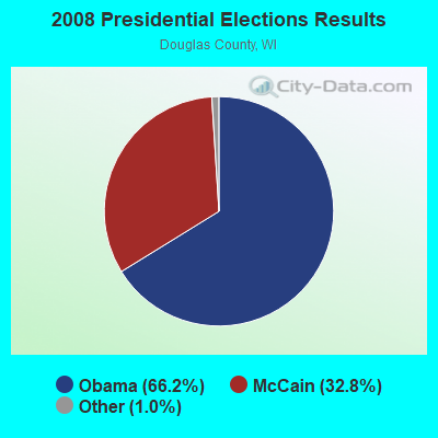
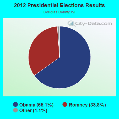

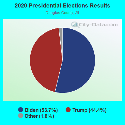
Graphs represent county-level data. Detailed 2008 Election Results
Religion statistics for Dairyland, WI (based on Douglas County data)
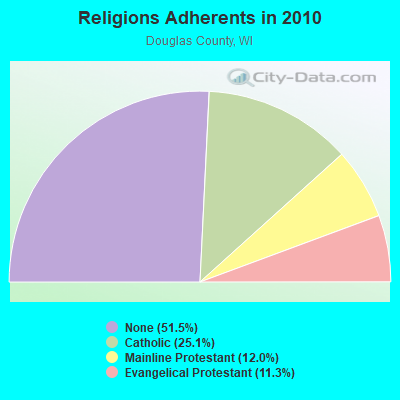
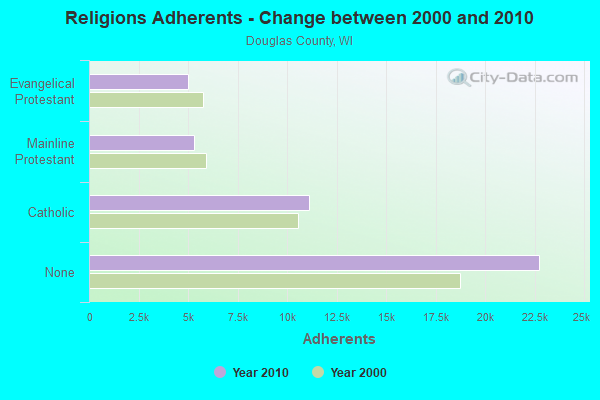
| Religion | Adherents | Congregations |
|---|---|---|
| Catholic | 11,104 | 8 |
| Mainline Protestant | 5,290 | 16 |
| Evangelical Protestant | 5,012 | 29 |
| Other | 14 | 2 |
| None | 22,739 | - |
Food Environment Statistics:
| Douglas County: | 2.06 / 10,000 pop. |
| Wisconsin: | 1.86 / 10,000 pop. |
| Douglas County: | 0.46 / 10,000 pop. |
| Wisconsin: | 0.38 / 10,000 pop. |
| Douglas County: | 5.26 / 10,000 pop. |
| Wisconsin: | 4.12 / 10,000 pop. |
| Douglas County: | 9.15 / 10,000 pop. |
| Wisconsin: | 8.64 / 10,000 pop. |
| This county: | 7.9% |
| Wisconsin: | 7.6% |
| Douglas County: | 27.0% |
| Wisconsin: | 27.5% |
| Douglas County: | 14.5% |
| State: | 13.0% |
Strongest AM radio stations in Dairyland:
- WEBC (560 AM; 50 kW; DULUTH, MN)
- WDSM (710 AM; 10 kW; SUPERIOR, WI; Owner: MIDWEST COMMUNICATIONS, INC.)
- WWJC (850 AM; daytime; 10 kW; DULUTH, MN; Owner: WWJC, INC.)
- WCCO (830 AM; 50 kW; MINNEAPOLIS, MN; Owner: INFINITY MEDIA CORPORATION)
- KDAL (610 AM; 5 kW; DULUTH, MN; Owner: MIDWEST COMMUNICATIONS, INC.)
- WCTS (1030 AM; 50 kW; MAPLEWOOD, MN; Owner: CNTL. BAPT. THEO/AL SEMI MINNEAPOLIS)
- WHSM (910 AM; 5 kW; HAYWARD, WI; Owner: QB BROADCASTING, LTD.)
- KSTP (1500 AM; 50 kW; ST. PAUL, MN; Owner: KSTP-AM, LLC (DELAWARE))
- KTIS (900 AM; 25 kW; MINNEAPOLIS, MN; Owner: NORTHWESTERN COLLEGE)
- KFAN (1130 AM; 50 kW; MINNEAPOLIS, MN; Owner: AMFM RADIO LICENSES, L.L.C.)
- WNMT (650 AM; 10 kW; NASHWAUK, MN; Owner: MIDWEST RADIO NETWORK, L.L.C.)
- WAQE (1090 AM; daytime; 5 kW; RICE LAKE, WI; Owner: TKC, INC.)
- WSPT (1010 AM; 50 kW; STEVENS POINT, WI)
Strongest FM radio stations in Dairyland:
- KBMX (107.7 FM; PROCTOR, MN; Owner: REGENT BROADCASTING OF DULUTH, INC.)
- WWAX (92.1 FM; HERMANTOWN, MN; Owner: RED ROCK RADIO CORP.)
- WSCN (100.5 FM; CLOQUET, MN; Owner: MINNESOTA PUBLIC RADIO)
- KDNI (90.5 FM; DULUTH, MN; Owner: NORTHWESTERN COLLEGE)
- KQDS-FM (94.9 FM; DULUTH, MN; Owner: RED ROCK RADIO CORP.)
- KLDJ (101.7 FM; DULUTH, MN; Owner: REGENT BROADCASTING OF DULUTH, INC.)
- KUMD-FM (103.3 FM; DULUTH, MN; Owner: REGENTS OF UNIVERSITY OF MINNESOTA)
- KDAL-FM (95.7 FM; DULUTH, MN; Owner: MIDWEST COMMUNICATIONS, INC.)
- KKCB (105.1 FM; DULUTH, MN; Owner: REGENT BROADCASTING OF DULUTH, INC.)
TV broadcast stations around Dairyland:
- WDIO-TV (Channel 10; DULUTH, MN; Owner: WDIO-TV, LLC)
- KDLH (Channel 3; DULUTH, MN; Owner: CHELSEY BROADCASTING COMPANY OF DULUTH, LLC)
- KBJR-TV (Channel 6; SUPERIOR, WI; Owner: KBJR LICENSE, INC.)
- National Bridge Inventory (NBI) Statistics
- 12Number of bridges
- 62ft / 19.1mTotal length
- $491,000Total costs
- 3,909Total average daily traffic
- 324Total average daily truck traffic
- 4,416Total future (year 2036) average daily traffic

- New bridges - historical statistics
- 11920-1929
- 11930-1939
- 21950-1959
- 31990-1999
- 22000-2009
- 32010-2019
FCC Registered Cell Phone Towers:
1- South Smith Road (110185) (Lat: 46.218361 Lon: -92.140667), Type: Gtower, Structure height: 121.9 m, Overall height: 128 m, Call Sign: KNKA504
Assigned Frequencies: 869.040 MHz, 869.040 MHz, 869.040 MHz, 824.040 MHz, 824.040 MHz, 824.040 MHz, 890.010 MHz, 890.010 MHz, 890.010 MHz, 845.010 MHz, 845.010 MHz, 845.010 MHzGrant Date: 01/03/2018, Expiration Date: 01/22/2028, Certifier: Michael P GogginRegistrant: At&t Services, Inc., 208 S Akard St, 20f, Dallas, TX 75202, Phone: (855) 699-7073, Email:
FCC Registered Antenna Towers:
2- Dennis C Olson, 32 Mi S Of Superior On Hwy 35 (Lat: 46.241389 Lon: -92.155000), Type: 76.5, Overall height: 71 m, Registrant: United Power Association, Jgoodin@upa.Com, , 800 Elk R-iver, Phone: (612) 441-3121
- 32 Mi S Of Superior On Hwy 35 (Lat: 46.241389 Lon: -92.155000), Type: 76.5, Overall height: 71 m, Registrant: United Power Association, Jgoodin@upa.Com, , 800 Elk R-iver, Phone: (612) 441-3121
FCC Registered Broadcast Land Mobile Towers:
2- Hwy 35 1.5 Mi N (Lat: 46.241333 Lon: -92.154917), Call Sign: WNDV436,
Assigned Frequencies: 154.463 MHz, Grant Date: 09/23/2015, Expiration Date: 10/10/2025, Certifier: James L Goodin, Registrant: B V Larson Inc., 1082 West Bone Lake Ln, Milltown, WI 54858, Phone: (715) 857-5557, Fax: (715) 857-5557, Email:
- Hwy 35 1.5 Mi N (Lat: 46.241333 Lon: -92.154917), Call Sign: WXY732,
Assigned Frequencies: 153.605 MHz, Grant Date: 09/18/2000, Expiration Date: 10/10/2005, Cancellation Date: 05/31/2005, Certifier: James L Goodin, Registrant: B V Larson Inc., 1082 West Bone Lake Ln, Milltown, WI 54858, Phone: (715) 857-5557, Fax: (715) 857-5557, Email:

- 45.7%Bottled, tank, or LP gas
- 33.7%Wood
- 12.0%Fuel oil, kerosene, etc.
- 8.7%Electricity

- 33.3%Utility gas
- 33.3%Bottled, tank, or LP gas
- 33.3%Wood
Dairyland compared to Wisconsin state average:
- Median house value below state average.
- Unemployed percentage below state average.
- Black race population percentage significantly below state average.
- Hispanic race population percentage significantly below state average.
- Median age above state average.
- Foreign-born population percentage significantly below state average.
- Renting percentage significantly below state average.
- Length of stay since moving in significantly above state average.
- Number of rooms per house significantly below state average.
- House age significantly below state average.
- Number of college students significantly below state average.
- Percentage of population with a bachelor's degree or higher below state average.