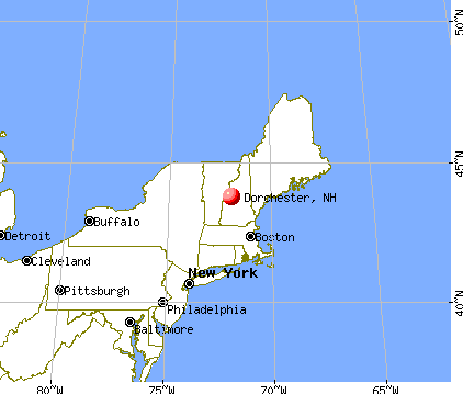
Dorchester, New Hampshire
Submit your own pictures of this town and show them to the world
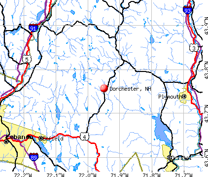
- OSM Map
- General Map
- Google Map
- MSN Map
Population change since 2000: +0.6%
 |
| Males: 187 | |
| Females: 168 |
| Median resident age: | 49.0 years |
| New Hampshire median age: | 43.9 years |
Zip codes: 03266.
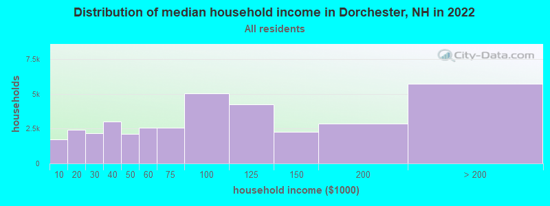
| Dorchester: | $79,838 |
| NH: | $89,992 |
Estimated per capita income in 2022: $43,069 (it was $18,940 in 2000)
Dorchester town income, earnings, and wages data
Estimated median house or condo value in 2022: $265,606 (it was $83,100 in 2000)
| Dorchester: | $265,606 |
| NH: | $384,700 |
Mean prices in 2022: all housing units: $486,096; detached houses: $533,852; townhouses or other attached units: $375,744; in 2-unit structures: $230,260; in 3-to-4-unit structures: $242,363; in 5-or-more-unit structures: $588,257; mobile homes: $127,035
Detailed information about poverty and poor residents in Dorchester, NH
Compare current foreclosures near Dorchester, NH:
| Photo | Address | Area | Beds / Baths | Price | Details |
|---|---|---|---|---|---|

|
#1
Route 25a
Orford, NH 03777
|
2,222 sq. feet
|
2 baths 3 beds |
$564,900
|
show details |

|
#2
Prospect Hill Rd
Canaan, NH 03741
|
- sq. feet
|
1 baths 3 beds |
show details | |

|
#3
Streeter Woods Rd
Rumney, NH 03266
|
- sq. feet
|
- baths - beds |
show details | |

|
#4
New Hebron Rd
Plymouth, NH 03264
|
- sq. feet
|
- baths - beds |
show details | |

|
#5
Us Route 4, Unit 5
Enfield, NH 03748
|
- sq. feet
|
- baths - beds |
show details | |

|
#6
Livermore Rd
Campton, NH 03223
|
- sq. feet
|
- baths - beds |
show details | |

|
#7
Fairgrounds Rd
Plymouth, NH 03264
|
- sq. feet
|
- baths - beds |
show details | |

|
#8
Mountain Rd
Fairlee, VT 05045
|
- sq. feet
|
- baths - beds |
show details | |

|
Check over 1 million property listings on Foreclosure.com!
|
browse all offers | |||

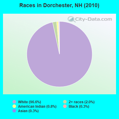
- 34396.6%White alone
- 72.0%Two or more races
- 30.8%American Indian alone
- 10.3%Black alone
- 10.3%Asian alone
Races in Dorchester detailed stats: ancestries, foreign born residents, place of birth
According to our research of New Hampshire and other state lists, there were 3 registered sex offenders living in Dorchester, New Hampshire as of April 25, 2024.
The ratio of all residents to sex offenders in Dorchester is 118 to 1.
 Recent articles from our blog. Our writers, many of them Ph.D. graduates or candidates, create easy-to-read articles on a wide variety of topics.


 | Why Isn't NH Population Booming? (110 replies) |
| Online Thieves Steal $2.3 Million from Peterborough (35 replies) |
| Yet Another Guy Looking to Relocate to Southern NH (27 replies) |
| Meredith NH - Other Towns? (30 replies) |
| Manchester/Nashua art scene (1 reply) |
| NH Drug Testing Bill for Healthcare Workers (51 replies) |
Latest news from Dorchester, NH collected exclusively by city-data.com from local newspapers, TV, and radio stations
Ancestries: French (29.5%), English (18.7%), Irish (16.4%), United States (13.6%), German (8.5%), Polish (7.4%).
Current Local Time: EST time zone
Incorporated in 1761
Elevation: 1368 feet
Land area: 44.7 square miles.
Population density: 7.9 people per square mile (very low).
20 residents are foreign born (2.8% North America, 1.4% Europe, 0.8% Latin America).
| This town: | 5.7% |
| New Hampshire: | 4.4% |
| Dorchester town: | 1.7% ($1,422) |
| New Hampshire: | 2.3% ($2,946) |
Nearest city with pop. 50,000+: Manchester, NH  (61.4 miles , pop. 107,006).
Nearest city with pop. 200,000+: Boston, MA (110.9 miles , pop. 589,141).
Nearest city with pop. 1,000,000+: Bronx, NY (226.3 miles , pop. 1,332,650).
Nearest cities:
), ), ), ), ), Latitude: 43.80 N, Longitude: 71.95 W
Area code commonly used in this area: 603

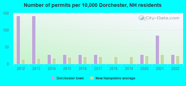
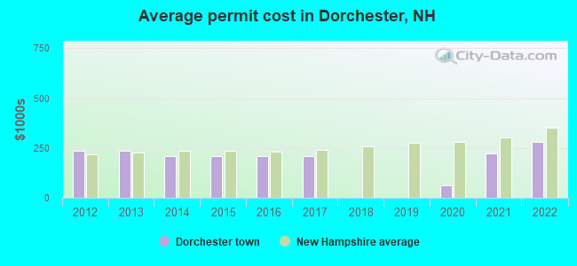
Single-family new house construction building permits:
- 2022: 1 building, cost: $279,200
- 2021: 3 buildings, average cost: $223,700
- 2020: 1 building, cost: $61,800
- 2017: 1 building, cost: $211,200
- 2016: 1 building, cost: $211,200
- 2015: 1 building, cost: $211,200
- 2014: 1 building, cost: $211,200
- 2013: 5 buildings, average cost: $236,600
- 2012: 5 buildings, average cost: $236,600
| Here: | 2.6% |
| New Hampshire: | 2.5% |
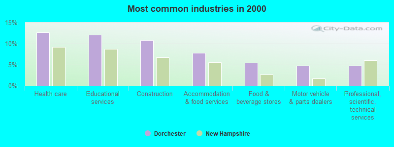
- Health care (12.7%)
- Educational services (12.0%)
- Construction (10.8%)
- Accommodation & food services (7.8%)
- Food & beverage stores (5.4%)
- Motor vehicle & parts dealers (4.8%)
- Professional, scientific, technical services (4.8%)
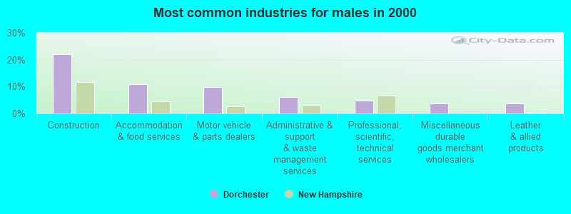
- Construction (22.0%)
- Accommodation & food services (11.0%)
- Motor vehicle & parts dealers (9.8%)
- Administrative & support & waste management services (6.1%)
- Professional, scientific, technical services (4.9%)
- Miscellaneous durable goods merchant wholesalers (3.7%)
- Leather & allied products (3.7%)
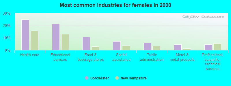
- Health care (25.0%)
- Educational services (21.4%)
- Food & beverage stores (10.7%)
- Social assistance (7.1%)
- Public administration (6.0%)
- Metal & metal products (4.8%)
- Professional, scientific, technical services (4.8%)
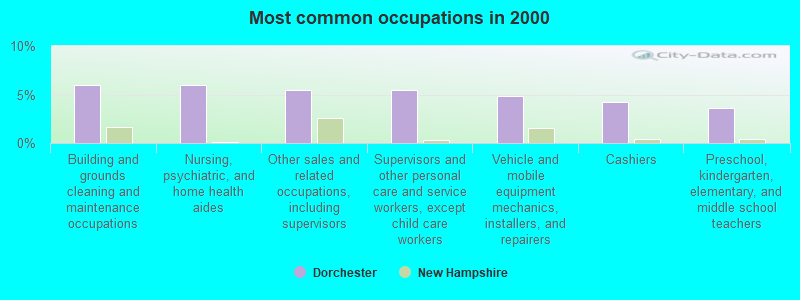
- Building and grounds cleaning and maintenance occupations (6.0%)
- Nursing, psychiatric, and home health aides (6.0%)
- Other sales and related occupations, including supervisors (5.4%)
- Supervisors and other personal care and service workers, except child care workers (5.4%)
- Vehicle and mobile equipment mechanics, installers, and repairers (4.8%)
- Cashiers (4.2%)
- Preschool, kindergarten, elementary, and middle school teachers (3.6%)
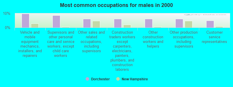
- Vehicle and mobile equipment mechanics, installers, and repairers (9.8%)
- Supervisors and other personal care and service workers, except child care workers (8.5%)
- Other sales and related occupations, including supervisors (6.1%)
- Construction traders workers except carpenters, electricians, painters, plumbers, and construction laborers (6.1%)
- Other construction workers and helpers (6.1%)
- Other production occupations, including supervisors (6.1%)
- Customer service representatives (4.9%)
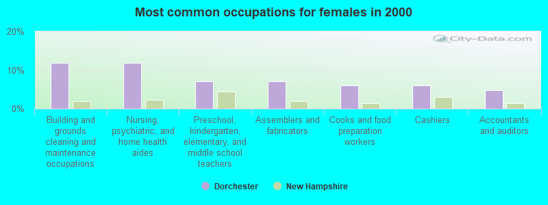
- Building and grounds cleaning and maintenance occupations (11.9%)
- Nursing, psychiatric, and home health aides (11.9%)
- Preschool, kindergarten, elementary, and middle school teachers (7.1%)
- Assemblers and fabricators (7.1%)
- Cooks and food preparation workers (6.0%)
- Cashiers (6.0%)
- Accountants and auditors (4.8%)
Average climate in Dorchester, New Hampshire
Based on data reported by over 4,000 weather stations


(lower is better)
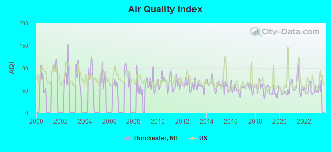
Air Quality Index (AQI) level in 2022 was 51.6. This is significantly better than average.
| City: | 51.6 |
| U.S.: | 72.6 |
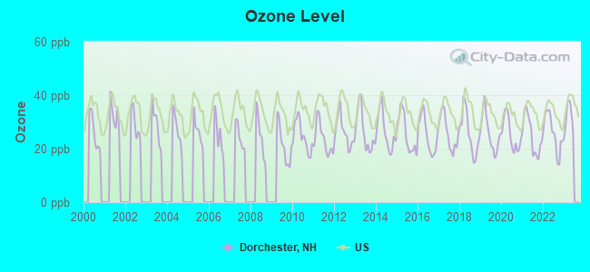
Ozone [ppb] level in 2022 was 25.9. This is better than average. Closest monitor was 10.0 miles away from the city center.
| City: | 25.9 |
| U.S.: | 33.3 |
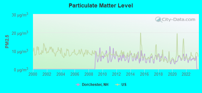
Particulate Matter (PM2.5) [µg/m3] level in 2022 was 5.54. This is significantly better than average. Closest monitor was 13.6 miles away from the city center.
| City: | 5.54 |
| U.S.: | 8.11 |
Tornado activity:
Dorchester-area historical tornado activity is below New Hampshire state average. It is 70% smaller than the overall U.S. average.
On 5/11/1973, a category F2 (max. wind speeds 113-157 mph) tornado 15.6 miles away from the Dorchester town center .
On 8/11/1966, a category F2 tornado 15.9 miles away from the town center caused between $50,000 and $500,000 in damages.
Earthquake activity:
Dorchester-area historical earthquake activity is significantly above New Hampshire state average. It is 71% smaller than the overall U.S. average.On 4/20/2002 at 10:50:47, a magnitude 5.3 (5.3 ML, Depth: 3.0 mi, Class: Moderate, Intensity: VI - VII) earthquake occurred 99.7 miles away from the city center
On 10/7/1983 at 10:18:46, a magnitude 5.3 (5.1 MB, 5.3 LG, 5.1 ML) earthquake occurred 119.6 miles away from the city center
On 4/20/2002 at 10:50:47, a magnitude 5.2 (5.2 MB, 4.2 MS, 5.2 MW, 5.0 MW) earthquake occurred 99.8 miles away from Dorchester center
On 1/19/1982 at 00:14:42, a magnitude 4.7 (4.5 MB, 4.7 MD, 4.5 LG, Class: Light, Intensity: IV - V) earthquake occurred 27.0 miles away from the city center
On 10/16/2012 at 23:12:25, a magnitude 4.7 (4.7 ML, Depth: 10.0 mi) earthquake occurred 66.3 miles away from the city center
On 6/16/1995 at 12:13:11, a magnitude 3.8 (3.8 LG, Depth: 3.1 mi, Class: Light, Intensity: II - III) earthquake occurred 34.0 miles away from the city center
Magnitude types: regional Lg-wave magnitude (LG), body-wave magnitude (MB), duration magnitude (MD), local magnitude (ML), surface-wave magnitude (MS), moment magnitude (MW)
Natural disasters:
The number of natural disasters in Grafton County (32) is a lot greater than the US average (15).Major Disasters (Presidential) Declared: 20
Emergencies Declared: 9
Causes of natural disasters: Floods: 16, Storms: 16, Hurricanes: 3, Snows: 3, Winter Storms: 3, Tropical Storms: 2, Blizzard: 1, Heavy Rain: 1, Ice Storm: 1, Landslide: 1, Snowfall: 1, Snowstorm: 1, Wind: 1, Other: 1 (Note: some incidents may be assigned to more than one category).

Colleges/universities with over 2000 students nearest to Dorchester:
- Plymouth State University (about 14 miles; Plymouth, NH; Full-time enrollment: 4,838)
- Dartmouth College (about 18 miles; Hanover, NH; FT enrollment: 6,030)
- Norwich University (about 43 miles; Northfield, VT; FT enrollment: 4,221)
- NHTI-Concord's Community College (about 45 miles; Concord, NH; FT enrollment: 2,865)
- Southern New Hampshire University (about 58 miles; Manchester, NH; FT enrollment: 16,552)
- Saint Anselm College (about 61 miles; Manchester, NH; FT enrollment: 2,059)
- Mount Washington College (about 62 miles; Manchester, NH; FT enrollment: 2,187)
Points of interest:
Notable location: DOC Camp (A). Display/hide its location on the map
Church in Dorchester: Dorchester Community Church (A). Display/hide its location on the map
Lakes and reservoirs: Bryant Pond (A), Mudgetts Pond (B), McCutcheon Pond (C), Cummins Pond (D), Reservoir Pond (E). Display/hide their locations on the map
Streams, rivers, and creeks: Merrill Brook (A), Rocky Brook (B), Bucks Brook (C), Meadow Brook (D), Clough Branch (E), Black Brook (F). Display/hide their locations on the map
Park in Dorchester: Dorchester Common Historic District (1). Display/hide its location on the map
Birthplace of: Rufus Blodgett - Politician.
| This town: | 2.4 people |
| New Hampshire: | 2.5 people |
| This town: | 65.5% |
| Whole state: | 66.3% |
| This town: | 12.2% |
| Whole state: | 8.3% |
Likely homosexual households (counted as self-reported same-sex unmarried-partner households)
- Lesbian couples: 0.0% of all households
- Gay men: 2.0% of all households
| This town: | 11.3% |
| Whole state: | 6.5% |
| This town: | 0.5% |
| Whole state: | 2.8% |
For population 15 years and over in Dorchester:
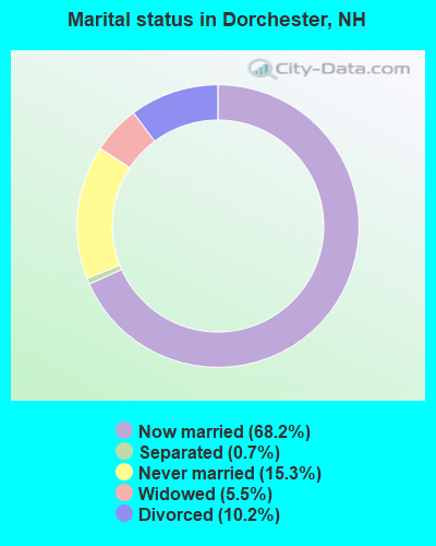
- Never married: 15.3%
- Now married: 68.2%
- Separated: 0.7%
- Widowed: 5.5%
- Divorced: 10.2%
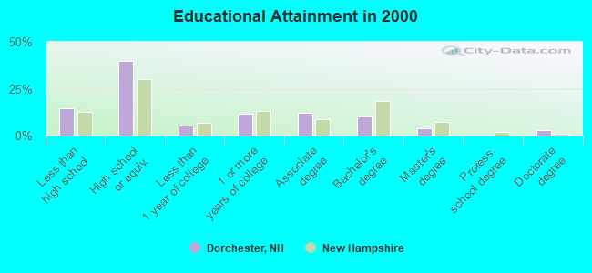
For population 25 years and over in Dorchester:
- High school or higher: 85.5%
- Bachelor's degree or higher: 16.9%
- Graduate or professional degree: 6.8%
- Unemployed: 10.8%
- Mean travel time to work (commute): 39.1 minutes
| Here: | 10.6 |
| New Hampshire average: | 10.9 |


Graphs represent county-level data. Detailed 2008 Election Results
Religion statistics for Dorchester, NH (based on Grafton County data)


| Religion | Adherents | Congregations |
|---|---|---|
| Catholic | 9,503 | 12 |
| Mainline Protestant | 7,832 | 57 |
| Evangelical Protestant | 1,494 | 29 |
| Other | 1,320 | 11 |
| None | 68,969 | - |
Food Environment Statistics:
| Grafton County: | 3.87 / 10,000 pop. |
| New Hampshire: | 2.14 / 10,000 pop. |
| Grafton County: | 0.23 / 10,000 pop. |
| State: | 0.15 / 10,000 pop. |
| Grafton County: | 1.29 / 10,000 pop. |
| New Hampshire: | 1.78 / 10,000 pop. |
| Grafton County: | 6.45 / 10,000 pop. |
| New Hampshire: | 4.02 / 10,000 pop. |
| Here: | 14.41 / 10,000 pop. |
| New Hampshire: | 9.70 / 10,000 pop. |
| Grafton County: | 7.2% |
| State: | 7.6% |
| Grafton County: | 22.9% |
| New Hampshire: | 24.4% |
| Grafton County: | 15.9% |
| State: | 15.9% |
Strongest AM radio stations in Dorchester:
- WPNH (1300 AM; 5 kW; PLYMOUTH, NH; Owner: NORTHEAST COMMUNICATIONS CORPORATION)
- WNTK (1020 AM; 10 kW; NEWPORT, NH; Owner: KOOR COMMUNICATIONS, INC.)
- WRKO (680 AM; 50 kW; BOSTON, MA; Owner: ENTERCOM BOSTON LICENSE, LLC)
- WTWN (1100 AM; daytime; 5 kW; WELLS RIVER, VT; Owner: PUFFER BROADCASTING, INC.)
- WNNZ (640 AM; 50 kW; WESTFIELD, MA; Owner: CLEAR CHANNEL BROADCASTING LICENSES, INC.)
- WCRN (830 AM; 50 kW; WORCESTER, MA; Owner: CARTER BROADCASTING CORPORATION)
- WEEI (850 AM; 50 kW; BOSTON, MA; Owner: ENTERCOM BOSTON LICENSE, LLC)
- WEZS (1350 AM; 5 kW; LACONIA, NH; Owner: GARY W. HAMMOND)
- WGY (810 AM; 50 kW; SCHENECTADY, NY; Owner: CLEAR CHANNEL BROADCASTING LICENSES, INC.)
- WCHP (760 AM; 35 kW; CHAMPLAIN, NY; Owner: CHAMPLAIN RADIO, INC.)
- WKOX (1200 AM; 50 kW; FRAMINGHAM, MA; Owner: CAPSTAR TX LIMITED PARTNERSHIP)
- WBZ (1030 AM; 50 kW; BOSTON, MA; Owner: INFINITY BROADCASTING OPERATIONS, INC.)
- WBIX (1060 AM; 40 kW; NATICK, MA; Owner: LANGER BROADCASTING CORPORATION)
Strongest FM radio stations in Dorchester:
- WPNH-FM (100.1 FM; PLYMOUTH, NH; Owner: NORTHEAST COMMUNICATIONS CORPORATION)
- WEVH (91.3 FM; HANOVER, NH; Owner: NEW HAMPSHIRE PUBLIC RADIO INC)
- WVFM (105.7 FM; CAMPTON, NH; Owner: DEVON BROADCASTING COMPANY, INC.)
- WPKQ (103.7 FM; NORTH CONWAY, NH; Owner: CITADEL BROADCASTING COMPANY)
- WHOM (94.9 FM; MT. WASHINGTON, NH; Owner: CITADEL BROADCASTING COMPANY)
- WHDQ (106.1 FM; CLAREMONT, NH; Owner: GREAT NORTHERN RADIO, L.L.C.)
- WSCY (106.9 FM; MOULTONBOROUGH, NH; Owner: NORTHEAST COMMUNICATIONS CORPORATION)
- WVPR (89.5 FM; WINDSOR, VT; Owner: VERMONT PUBLIC RADIO)
- WJJR (98.1 FM; RUTLAND, VT; Owner: 6 JOHNSON ROAD LICENSES, INC.)
- WZRT (97.1 FM; RUTLAND, VT; Owner: CAPSTAR TX LIMITED PARTNERSHIP)
- WEBK (105.3 FM; KILLINGTON, VT; Owner: 6 JOHNSON ROAD LICENSES, INC.)
- WGLV (91.7 FM; WOODSTOCK, VT; Owner: CHRISTIAN MINISTRIES INC)
- WHDQ-FM1 (106.1 FM; RUTLAND, VT; Owner: GREAT NORTHERN RADIO, L.L.C.)
- WXXK (100.5 FM; LEBANON, NH; Owner: CAPSTAR TX LIMITED PARTNERSHIP)
- WDEV-FM (96.1 FM; WARREN, VT; Owner: RADIO VERMONT, INC.)
- WCVT (101.7 FM; STOWE, VT; Owner: RADIO VERMONT CLASSICS, L.L.C.)
- WRJT (103.1 FM; ROYALTON, VT; Owner: LISBON COMMUNICATIONS, INC.)
- WVRR (101.7 FM; NEWPORT, NH; Owner: CAPSTAR TX LIMITED PARTNERSHIP)
- WGMT (97.7 FM; LYNDON, VT; Owner: VERMONT BROADCAST ASSOCIATES, INC.)
- WVPS (107.9 FM; BURLINGTON, VT; Owner: VERMONT PUBLIC RADIO)
TV broadcast stations around Dorchester:
- W15BK (Channel 15; HANOVER, NH; Owner: UNIVERSITY OF NEW HAMPSHIRE)
- National Bridge Inventory (NBI) Statistics
- 5Number of bridges
- 16ft / 5.0mTotal length
- $15,710,000Total costs
- 299Total average daily traffic
- 6Total average daily truck traffic
- 439Total future (year 2042) average daily traffic
FCC Registered Amateur Radio Licenses:
1- Call Sign: KB3SBI, Licensee ID: L01447346, Grant Date: 04/11/2019, Expiration Date: 04/11/2029, Certifier: Craig W Veasey, Registrant: Craig W Veasey, 1137 Route 118, Dorchester, NH 03266
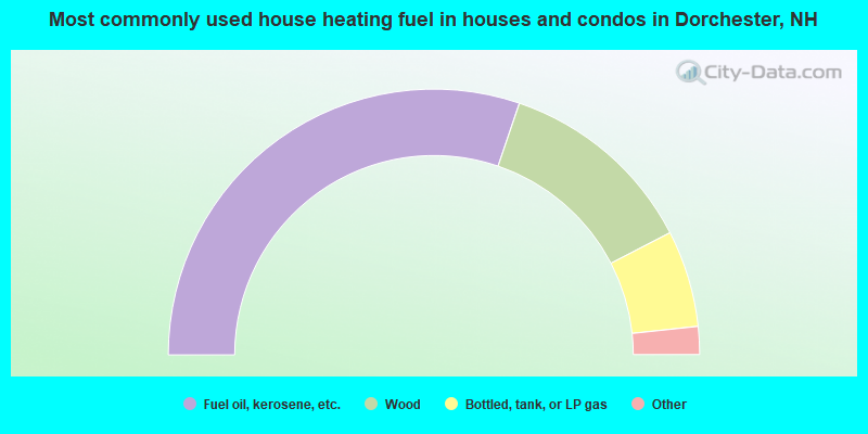
- 60.5%Fuel oil, kerosene, etc.
- 24.4%Wood
- 11.8%Bottled, tank, or LP gas
- 1.7%Electricity
- 1.7%Coal or coke
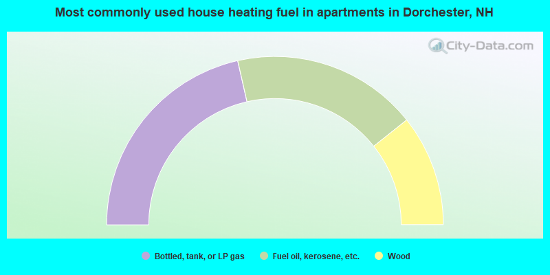
- 42.9%Bottled, tank, or LP gas
- 35.7%Fuel oil, kerosene, etc.
- 21.4%Wood
Dorchester compared to New Hampshire state average:
- Black race population percentage significantly below state average.
- Hispanic race population percentage significantly below state average.
- Median age above state average.
- Renting percentage significantly below state average.
- Length of stay since moving in significantly above state average.
- Number of rooms per house significantly below state average.
- House age significantly below state average.
- Number of college students significantly below state average.
- Percentage of population with a bachelor's degree or higher below state average.

|
Total of 2 patent applications in 2008-2024.