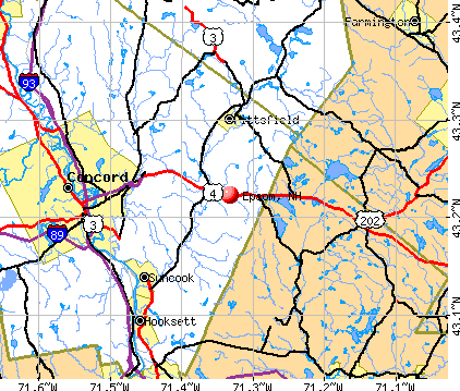
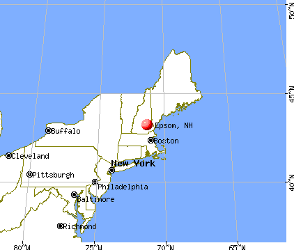
Epsom, New Hampshire
Submit your own pictures of this town and show them to the world
- OSM Map
- General Map
- Google Map
- MSN Map
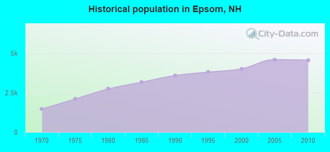
Population change since 2000: +13.6%
 |
| Males: 2,238 | |
| Females: 2,328 |
| Median resident age: | 43.0 years |
| New Hampshire median age: | 43.9 years |
Zip codes: 03234.
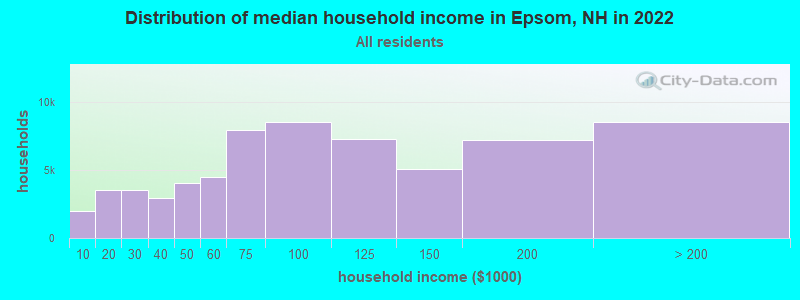
| Epsom: | $88,465 |
| NH: | $89,992 |
Estimated per capita income in 2022: $44,120 (it was $22,026 in 2000)
Epsom town income, earnings, and wages data
Estimated median house or condo value in 2022: $336,103 (it was $107,400 in 2000)
| Epsom: | $336,103 |
| NH: | $384,700 |
Mean prices in 2022: all housing units: $378,901; detached houses: $416,256; townhouses or other attached units: $317,750; in 2-unit structures: $298,869; in 3-to-4-unit structures: $371,619; in 5-or-more-unit structures: $216,601; mobile homes: $110,180; occupied boats, rvs, vans, etc.: $74,347
Detailed information about poverty and poor residents in Epsom, NH


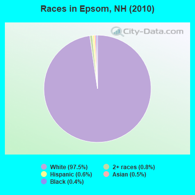
- 4,45497.5%White alone
- 360.8%Two or more races
- 280.6%Hispanic
- 240.5%Asian alone
- 180.4%Black alone
- 30.07%American Indian alone
- 30.07%Other race alone
Races in Epsom detailed stats: ancestries, foreign born residents, place of birth
According to our research of New Hampshire and other state lists, there were 9 registered sex offenders living in Epsom, New Hampshire as of April 25, 2024.
The ratio of all residents to sex offenders in Epsom is 507 to 1.
The ratio of registered sex offenders to all residents in this city is near the state average.
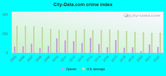
Type |
2009 |
2010 |
2011 |
2012 |
2013 |
2014 |
2015 |
2016 |
2017 |
2018 |
2019 |
2020 |
2021 |
2022 |
|---|---|---|---|---|---|---|---|---|---|---|---|---|---|---|
| Murders (per 100,000) | 0 (0.0) | 0 (0.0) | 0 (0.0) | 0 (0.0) | 0 (0.0) | 0 (0.0) | 0 (0.0) | 0 (0.0) | 0 (0.0) | 0 (0.0) | 0 (0.0) | 0 (0.0) | 0 (0.0) | 0 (0.0) |
| Rapes (per 100,000) | 0 (0.0) | 3 (65.7) | 1 (21.9) | 1 (21.8) | 2 (43.3) | 6 (130.5) | 1 (21.5) | 1 (21.5) | 4 (85.1) | 1 (21.2) | 2 (41.9) | 0 (0.0) | 4 (82.5) | 2 (40.3) |
| Robberies (per 100,000) | 0 (0.0) | 0 (0.0) | 0 (0.0) | 2 (43.7) | 0 (0.0) | 0 (0.0) | 0 (0.0) | 0 (0.0) | 0 (0.0) | 0 (0.0) | 0 (0.0) | 0 (0.0) | 0 (0.0) | 0 (0.0) |
| Assaults (per 100,000) | 5 (107.7) | 2 (43.8) | 5 (109.4) | 5 (109.2) | 0 (0.0) | 1 (21.7) | 5 (107.7) | 3 (64.5) | 8 (170.2) | 3 (63.7) | 1 (20.9) | 0 (0.0) | 1 (20.6) | 2 (40.3) |
| Burglaries (per 100,000) | 9 (193.8) | 11 (240.9) | 33 (721.8) | 18 (393.0) | 16 (346.3) | 14 (304.5) | 10 (215.4) | 5 (107.4) | 9 (191.4) | 5 (106.2) | 3 (62.8) | 1 (20.9) | 0 (0.0) | 1 (20.2) |
| Thefts (per 100,000) | 40 (861.5) | 82 (1,796) | 41 (896.8) | 38 (829.7) | 49 (1,061) | 34 (739.5) | 42 (904.8) | 25 (537.2) | 18 (382.9) | 15 (318.7) | 23 (481.5) | 17 (355.1) | 24 (495.0) | 21 (423.6) |
| Auto thefts (per 100,000) | 3 (64.6) | 2 (43.8) | 4 (87.5) | 6 (131.0) | 2 (43.3) | 0 (0.0) | 1 (21.5) | 1 (21.5) | 3 (63.8) | 4 (85.0) | 0 (0.0) | 2 (41.8) | 0 (0.0) | 4 (80.7) |
| Arson (per 100,000) | 0 (0.0) | 0 (0.0) | 0 (0.0) | 1 (21.8) | 0 (0.0) | 0 (0.0) | 1 (21.5) | 0 (0.0) | 0 (0.0) | 0 (0.0) | 0 (0.0) | 0 (0.0) | 0 (0.0) | 0 (0.0) |
| City-Data.com crime index | 74.7 | 153.5 | 132.8 | 123.6 | 104.8 | 159.6 | 91.8 | 60.8 | 135.9 | 56.7 | 61.3 | 19.0 | 89.9 | 65.2 |
The City-Data.com crime index weighs serious crimes and violent crimes more heavily. Higher means more crime, U.S. average is 246.1. It adjusts for the number of visitors and daily workers commuting into cities.
Crime rate in Epsom detailed stats: murders, rapes, robberies, assaults, burglaries, thefts, arson
Full-time law enforcement employees in 2021, including police officers: 7 (6 officers - 6 male; 0 female).
| Officers per 1,000 residents here: | 1.24 |
| New Hampshire average: | 2.14 |
 Recent articles from our blog. Our writers, many of them Ph.D. graduates or candidates, create easy-to-read articles on a wide variety of topics.


 | So ashamed of my state (330 replies) |
| New Hampshire Still Gaining Population (18 replies) |
| Moving from MA to NH Town Suggestions to Start a Family (5 replies) |
| NHAR Study Claims More Students Does Not Mean Higher Property Taxes (10 replies) |
| Thinking of moving to New Hampshire from WA (40 replies) |
| Where to find winter driving conditions report online? (7 replies) |
Latest news from Epsom, NH collected exclusively by city-data.com from local newspapers, TV, and radio stations
Ancestries: English (21.5%), French (19.6%), Irish (15.9%), French Canadian (12.0%), United States (7.5%), German (6.4%).
Current Local Time: EST time zone
Incorporated in 1727
Elevation: 394 feet
Land area: 34.2 square miles.
Population density: 134 people per square mile (very low).
89 residents are foreign born (1.7% North America, 0.5% Europe).
| This town: | 2.2% |
| New Hampshire: | 4.4% |
| Epsom town: | 2.2% ($2,322) |
| New Hampshire: | 2.3% ($2,946) |
Nearest city with pop. 50,000+: Manchester, NH  (16.8 miles , pop. 107,006).
Nearest city with pop. 200,000+: Boston, MA (63.3 miles , pop. 589,141).
Nearest city with pop. 1,000,000+: Bronx, NY (209.0 miles , pop. 1,332,650).
Nearest cities:
), ), ), ), ), )Latitude: 43.22 N, Longitude: 71.35 W
Area code: 603

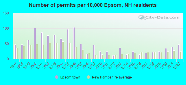
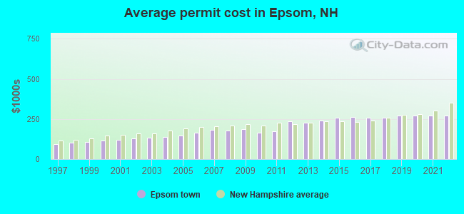
Single-family new house construction building permits:
- 2022: 19 buildings, average cost: $271,300
- 2021: 16 buildings, average cost: $271,300
- 2020: 14 buildings, average cost: $271,400
- 2019: 10 buildings, average cost: $270,900
- 2018: 9 buildings, average cost: $259,600
- 2017: 8 buildings, average cost: $259,500
- 2016: 6 buildings, average cost: $260,700
- 2015: 10 buildings, average cost: $255,600
- 2014: 6 buildings, average cost: $240,200
- 2013: 15 buildings, average cost: $228,700
- 2012: 5 buildings, average cost: $236,600
- 2011: 10 buildings, average cost: $172,800
- 2010: 10 buildings, average cost: $165,900
- 2009: 18 buildings, average cost: $188,600
- 2008: 7 buildings, average cost: $179,700
- 2007: 20 buildings, average cost: $181,200
- 2006: 42 buildings, average cost: $163,600
- 2005: 39 buildings, average cost: $149,300
- 2004: 27 buildings, average cost: $139,200
- 2003: 32 buildings, average cost: $132,800
- 2002: 31 buildings, average cost: $128,300
- 2001: 35 buildings, average cost: $120,700
- 2000: 41 buildings, average cost: $116,500
- 1999: 25 buildings, average cost: $106,500
- 1998: 19 buildings, average cost: $102,000
- 1997: 19 buildings, average cost: $91,500
| Here: | 2.0% |
| New Hampshire: | 2.5% |
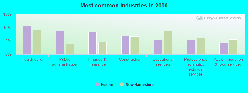
- Health care (10.5%)
- Public administration (8.8%)
- Finance & insurance (8.4%)
- Construction (6.9%)
- Educational services (5.5%)
- Professional, scientific, technical services (5.4%)
- Accommodation & food services (4.2%)
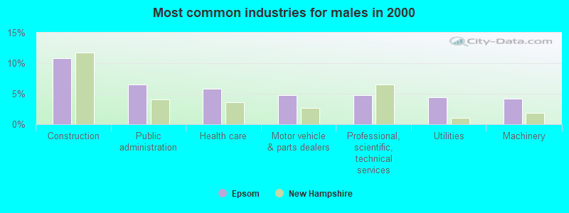
- Construction (10.8%)
- Public administration (6.5%)
- Health care (5.9%)
- Motor vehicle & parts dealers (4.7%)
- Professional, scientific, technical services (4.7%)
- Utilities (4.4%)
- Machinery (4.2%)
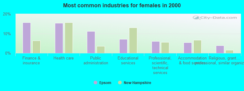
- Finance & insurance (15.7%)
- Health care (15.3%)
- Public administration (11.1%)
- Educational services (7.1%)
- Professional, scientific, technical services (6.1%)
- Accommodation & food services (5.4%)
- Religious, grantmaking, civic, professional, similar organizations (3.9%)
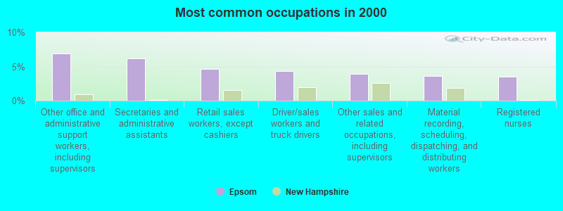
- Other office and administrative support workers, including supervisors (6.9%)
- Secretaries and administrative assistants (6.2%)
- Retail sales workers, except cashiers (4.6%)
- Driver/sales workers and truck drivers (4.3%)
- Other sales and related occupations, including supervisors (3.9%)
- Material recording, scheduling, dispatching, and distributing workers (3.6%)
- Registered nurses (3.5%)
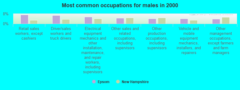
- Retail sales workers, except cashiers (7.2%)
- Driver/sales workers and truck drivers (6.8%)
- Electrical equipment mechanics and other installation, maintenance, and repair workers, including supervisors (5.7%)
- Other sales and related occupations, including supervisors (4.6%)
- Other production occupations, including supervisors (4.2%)
- Vehicle and mobile equipment mechanics, installers, and repairers (4.2%)
- Other management occupations, except farmers and farm managers (3.9%)
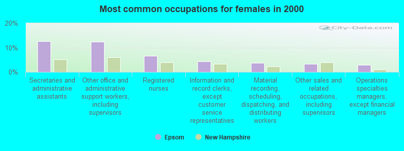
- Secretaries and administrative assistants (12.5%)
- Other office and administrative support workers, including supervisors (12.3%)
- Registered nurses (6.7%)
- Information and record clerks, except customer service representatives (4.3%)
- Material recording, scheduling, dispatching, and distributing workers (3.8%)
- Other sales and related occupations, including supervisors (3.2%)
- Operations specialties managers, except financial managers (3.0%)
Average climate in Epsom, New Hampshire
Based on data reported by over 4,000 weather stations


(lower is better)
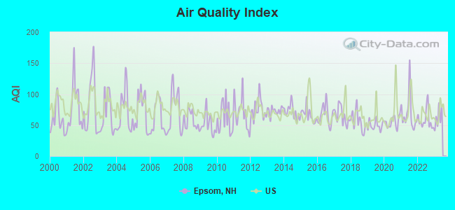
Air Quality Index (AQI) level in 2022 was 58.4. This is better than average.
| City: | 58.4 |
| U.S.: | 72.6 |
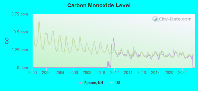
Carbon Monoxide (CO) [ppm] level in 2022 was 0.157. This is significantly better than average. Closest monitor was 16.4 miles away from the city center.
| City: | 0.157 |
| U.S.: | 0.251 |
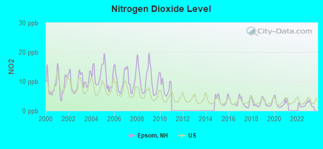
Nitrogen Dioxide (NO2) [ppb] level in 2022 was 2.05. This is significantly better than average. Closest monitor was 7.9 miles away from the city center.
| City: | 2.05 |
| U.S.: | 5.11 |
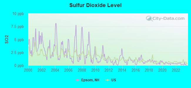
Sulfur Dioxide (SO2) [ppb] level in 2022 was 0.338. This is significantly better than average. Closest monitor was 6.3 miles away from the city center.
| City: | 0.338 |
| U.S.: | 1.515 |
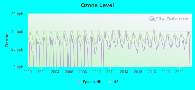
Ozone [ppb] level in 2022 was 28.9. This is about average. Closest monitor was 6.3 miles away from the city center.
| City: | 28.9 |
| U.S.: | 33.3 |
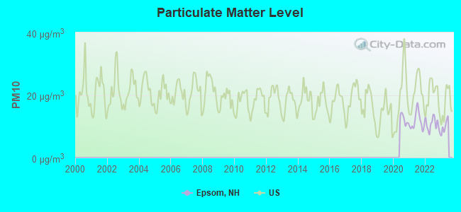
Particulate Matter (PM10) [µg/m3] level in 2022 was 10.6. This is significantly better than average. Closest monitor was 6.3 miles away from the city center.
| City: | 10.6 |
| U.S.: | 19.2 |
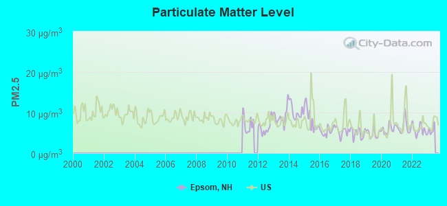
Particulate Matter (PM2.5) [µg/m3] level in 2022 was 5.71. This is significantly better than average. Closest monitor was 9.4 miles away from the city center.
| City: | 5.71 |
| U.S.: | 8.11 |
Tornado activity:
Epsom-area historical tornado activity is slightly above New Hampshire state average. It is 48% smaller than the overall U.S. average.
On 6/9/1953, a category F3 (max. wind speeds 158-206 mph) tornado 25.7 miles away from the Epsom town center injured 5 people and caused between $5000 and $50,000 in damages.
On 7/24/2008, a category F2 (max. wind speeds 113-157 mph) tornado 5.0 miles away from the town center killed one person and injured 2 people and caused $2 million in damages.
Earthquake activity:
Epsom-area historical earthquake activity is significantly above New Hampshire state average. It is 72% smaller than the overall U.S. average.On 4/20/2002 at 10:50:47, a magnitude 5.3 (5.3 ML, Depth: 3.0 mi, Class: Moderate, Intensity: VI - VII) earthquake occurred 147.4 miles away from Epsom center
On 1/19/1982 at 00:14:42, a magnitude 4.7 (4.5 MB, 4.7 MD, 4.5 LG, Class: Light, Intensity: IV - V) earthquake occurred 23.3 miles away from Epsom center
On 10/7/1983 at 10:18:46, a magnitude 5.3 (5.1 MB, 5.3 LG, 5.1 ML) earthquake occurred 158.3 miles away from the city center
On 4/20/2002 at 10:50:47, a magnitude 5.2 (5.2 MB, 4.2 MS, 5.2 MW, 5.0 MW) earthquake occurred 147.2 miles away from Epsom center
On 10/16/2012 at 23:12:25, a magnitude 4.7 (4.7 ML, Depth: 10.0 mi) earthquake occurred 43.7 miles away from Epsom center
On 8/21/1996 at 07:54:14, a magnitude 3.8 (3.8 LG, 3.6 LG, Depth: 6.2 mi, Class: Light, Intensity: II - III) earthquake occurred 66.9 miles away from Epsom center
Magnitude types: regional Lg-wave magnitude (LG), body-wave magnitude (MB), duration magnitude (MD), local magnitude (ML), surface-wave magnitude (MS), moment magnitude (MW)
Natural disasters:
The number of natural disasters in Merrimack County (27) is a lot greater than the US average (15).Major Disasters (Presidential) Declared: 17
Emergencies Declared: 9
Causes of natural disasters: Storms: 13, Floods: 12, Winter Storms: 4, Snowstorms: 3, Hurricanes: 2, Snows: 2, Blizzard: 1, Ice Storm: 1, Snowfall: 1, Tornado: 1, Tropical Storm: 1, Wind: 1, Other: 1 (Note: some incidents may be assigned to more than one category).

Hospitals and medical centers in Epsom:
Other hospitals and medical centers near Epsom:
- HAVENWOOD-HERITAGE HEIGHTS (Nursing Home, about 9 miles away; CONCORD, NH)
- HARRIS HILL CENTER, GENESIS HEALTHCARE (Nursing Home, about 10 miles away; CONCORD, NH)
- CONCORD REGIONAL VNA (Home Health Center, about 10 miles away; CONCORD, NH)
- NEW HAMPSHIRE HOSP-MED SURG BLDG (Hospital, about 10 miles away; CONCORD, NH)
- NEW HAMPSHIRE HOSP-PSYCH UNIT (Hospital, about 10 miles away; CONCORD, NH)
- N H HOSPITAL-PSYCHIATRIC NURSING HOME (Nursing Home, about 10 miles away; CONCORD, NH)
- PRESIDENTIAL OAKS (Nursing Home, about 11 miles away; CONCORD, NH)
Colleges/universities with over 2000 students nearest to Epsom:
- NHTI-Concord's Community College (about 10 miles; Concord, NH; Full-time enrollment: 2,865)
- Southern New Hampshire University (about 14 miles; Manchester, NH; FT enrollment: 16,552)
- Saint Anselm College (about 18 miles; Manchester, NH; FT enrollment: 2,059)
- Mount Washington College (about 19 miles; Manchester, NH; FT enrollment: 2,187)
- University of New Hampshire-Main Campus (about 22 miles; Durham, NH; FT enrollment: 15,243)
- Northern Essex Community College (about 33 miles; Haverhill, MA; FT enrollment: 4,737)
- University of Massachusetts-Lowell (about 39 miles; Lowell, MA; FT enrollment: 12,341)
Public elementary/middle school in Epsom:
- EPSOM CENTRAL SCHOOL (Students: 458, Location: 282 BLACK HALL RD., Grades: KG-8)
Private elementary/middle schools in Epsom:
- CORNERSTONE CHRISTIAN ACADEMY (Students: 46, Location: 398 BLACK HALL RD, Grades: KG-8)
- PATHFINDER ACADEMY (Students: 27, Location: 59 SAWYER AVE, Grades: PK-8)
Points of interest:
Notable location: Epsom Fire Department (A). Display/hide its location on the map
Churches in Epsom include: Epsom Baptist Church (A), New Rye Congregational Church (B). Display/hide their locations on the map
Cemeteries: Gossville Cemetery (1), McClary Cemetery (2). Display/hide their locations on the map
Lakes and reservoirs: Chestnut Pond (A), Odiorne Pond (B), Round Pond (C), Little River Reservoir (D), Bixby Pond (E). Display/hide their locations on the map
Streams, rivers, and creeks: Mason Brook (A), Marden Brook (B), Lockes Brook (C), Little Suncook River (D), Little Bear Brook (E), Leighton Brook (F), Gulf Brook (G), Griffin Brook (H), Fowler Brook (I). Display/hide their locations on the map
Park in Epsom: Webster Park (1). Display/hide its location on the map
Birthplace of: John B. Sanborn - Army general during Civil War, John Dolbeer - Inventor, Noah Martin - Politician.
Drinking water stations with addresses in Epsom and their reported violations in the past:
WENDYS/DUNKIN DONUTS (Population served: 999, Groundwater):Past health violations:EPSOM VILLAGE DIST (Population served: 750, Groundwater):
- MCL, Monthly (TCR) - Between APR-2012 and JUN-2012, Contaminant: Coliform. Follow-up actions: St Public Notif requested (JUL-05-2012), St Violation/Reminder Notice (JUL-05-2012), St Public Notif received (JUL-25-2012), St Compliance achieved (JAN-17-2013)
Past health violations:GRIGGS MOBILE HOMES (Population served: 73, Groundwater):
- MCL, Monthly (TCR) - In APR-2007, Contaminant: Coliform. Follow-up actions: St Public Notif requested (MAY-11-2007), St Violation/Reminder Notice (MAY-11-2007), St Public Notif received (MAY-18-2007), St Compliance achieved (OCT-31-2007)
Past monitoring violations:KINGS GRANT (Population served: 71, Groundwater):
- 33 regular monitoring violations
Past monitoring violations:COLBY BROOK ESTATES (Population served: 68, Groundwater):
- One routine major monitoring violation
Past health violations:HALCYON HILL (Population served: 58, Groundwater):Past monitoring violations:
- MCL, Monthly (TCR) - In JUN-2014, Contaminant: Coliform. Follow-up actions: St Violation/Reminder Notice (JUN-16-2014), St Public Notif requested (JUN-16-2014)
- MCL, Monthly (TCR) - In DEC-2013, Contaminant: Coliform. Follow-up actions: St Public Notif requested (DEC-17-2013), St Violation/Reminder Notice (DEC-17-2013), St Public Notif received (JAN-14-2014)
- MCL, Average - Between APR-2013 and JUN-2013, Contaminant: Arsenic. Follow-up actions: St Public Notif requested (JUN-11-2013), St Violation/Reminder Notice (JUN-11-2013), St Public Notif received (JUL-01-2013), St Compliance achieved (OCT-09-2013)
- MCL, Average - Between JAN-2013 and MAR-2013, Contaminant: Arsenic. Follow-up actions: St Public Notif requested (FEB-08-2013), St Violation/Reminder Notice (FEB-08-2013), St Public Notif received (FEB-15-2013), St Compliance achieved (OCT-09-2013)
- MCL, Average - Between OCT-2012 and DEC-2012, Contaminant: Arsenic. Follow-up actions: St Public Notif requested (FEB-08-2013), St Violation/Reminder Notice (FEB-08-2013), St Public Notif received (FEB-15-2013), St Compliance achieved (OCT-09-2013)
- MCL, Average - Between JUL-2012 and SEP-2012, Contaminant: Arsenic. Follow-up actions: St Public Notif requested (AUG-08-2012), St Violation/Reminder Notice (AUG-08-2012), St Public Notif received (AUG-27-2012), St Compliance achieved (OCT-09-2013)
- One routine major monitoring violation
- 2 regular monitoring violations
Past health violations:BARTON MHP (Population served: 43, Groundwater):Past monitoring violations:
- MCL, Average - Between JUL-2008 and SEP-2008, Contaminant: Combined Uranium. Follow-up actions: St Public Notif requested (NOV-13-2008), St Violation/Reminder Notice (NOV-13-2008), St Public Notif received (NOV-13-2008), St Compliance achieved (APR-03-2009)
- MCL, Average - Between APR-2008 and JUN-2008, Contaminant: Combined Uranium. Follow-up actions: St Public Notif requested (JUL-11-2008), St Violation/Reminder Notice (JUL-11-2008), St Public Notif received (JUL-11-2008), St Compliance achieved (APR-03-2009)
- MCL, Average - Between JAN-2008 and MAR-2008, Contaminant: Combined Uranium. Follow-up actions: St Public Notif requested (APR-18-2008), St Violation/Reminder Notice (APR-18-2008), St Public Notif received (APR-22-2008), St Compliance achieved (APR-03-2009)
- MCL, Average - Between APR-2007 and JUN-2007, Contaminant: Combined Uranium. Follow-up actions: St Public Notif requested (JUL-25-2007), St Violation/Reminder Notice (JUL-25-2007), St Public Notif received (AUG-14-2007), St Compliance achieved (APR-03-2009)
- One routine major monitoring violation
- 52 regular monitoring violations
Past monitoring violations:
- Lead Consumer Notice - In JUL-01-2012, Contaminant: Lead and Copper Rule. Follow-up actions: St Violation/Reminder Notice (JUL-10-2012), St Compliance achieved (JUL-16-2012)
- One routine major monitoring violation
- One regular monitoring violation
| This town: | 2.6 people |
| New Hampshire: | 2.5 people |
| This town: | 74.3% |
| Whole state: | 66.3% |
| This town: | 8.1% |
| Whole state: | 8.3% |
Likely homosexual households (counted as self-reported same-sex unmarried-partner households)
- Lesbian couples: 0.3% of all households
- Gay men: 0.5% of all households
| This town: | 3.1% |
| Whole state: | 6.5% |
| This town: | 2.4% |
| Whole state: | 2.8% |
117 people in nursing homes in 2000
Banks with branches in Epsom (2011 data):
- TD Bank, National Association: Epsom Branch at 1886 Dover Road, branch established on 1975/10/14. Info updated 2010/10/04: Bank assets: $188,912.6 mil, Deposits: $153,149.8 mil, headquarters in Wilmington, DE, positive income, 1314 total offices, Holding Company: Toronto-Dominion Bank, The
For population 15 years and over in Epsom:
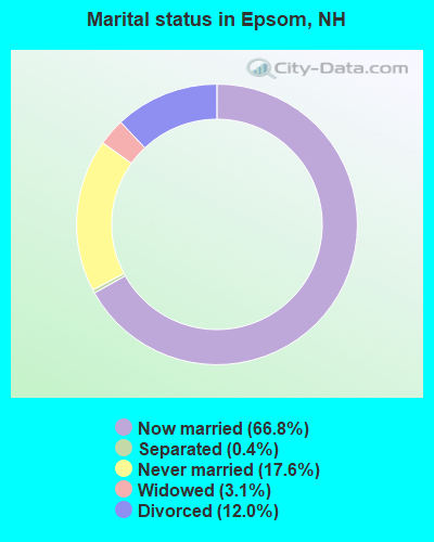
- Never married: 17.6%
- Now married: 66.8%
- Separated: 0.4%
- Widowed: 3.1%
- Divorced: 12.0%
For population 25 years and over in Epsom:
- High school or higher: 88.2%
- Bachelor's degree or higher: 22.4%
- Graduate or professional degree: 5.0%
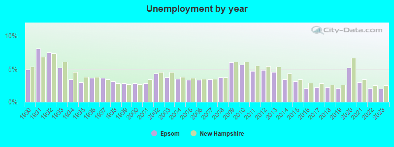
- Unemployed: 3.1%
- Mean travel time to work (commute): 27.0 minutes
| Here: | 9.5 |
| New Hampshire average: | 10.9 |
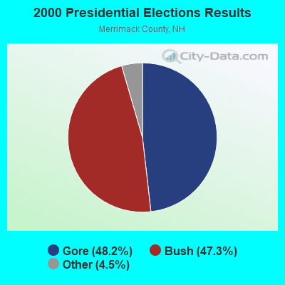
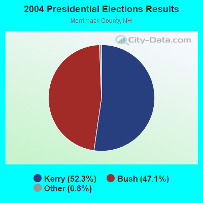

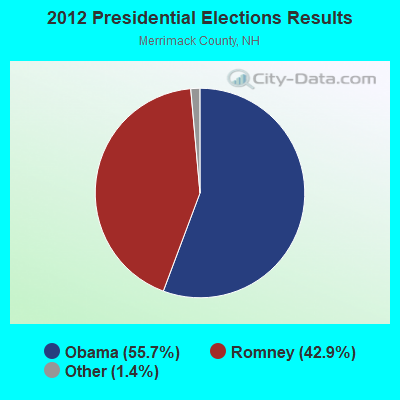
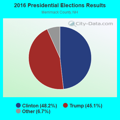
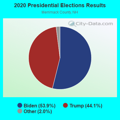
Graphs represent county-level data. Detailed 2008 Election Results
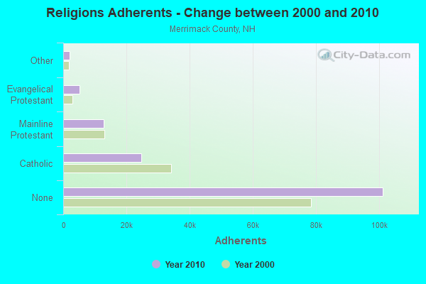
Religion statistics for Epsom, NH (based on Merrimack County data)
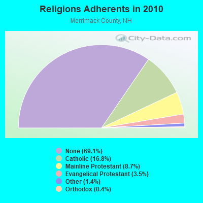
| Religion | Adherents | Congregations |
|---|---|---|
| Catholic | 24,654 | 7 |
| Mainline Protestant | 12,791 | 51 |
| Evangelical Protestant | 5,195 | 36 |
| Other | 2,097 | 15 |
| Orthodox | 580 | 2 |
| None | 101,128 | - |
Food Environment Statistics:
| Merrimack County: | 1.82 / 10,000 pop. |
| New Hampshire: | 2.14 / 10,000 pop. |
| Merrimack County: | 0.14 / 10,000 pop. |
| State: | 0.15 / 10,000 pop. |
| Merrimack County: | 1.22 / 10,000 pop. |
| State: | 1.78 / 10,000 pop. |
| This county: | 4.39 / 10,000 pop. |
| State: | 4.02 / 10,000 pop. |
| Merrimack County: | 7.77 / 10,000 pop. |
| New Hampshire: | 9.70 / 10,000 pop. |
| Here: | 7.4% |
| State: | 7.6% |
| Here: | 23.8% |
| New Hampshire: | 24.4% |
| This county: | 16.9% |
| New Hampshire: | 15.9% |
| Businesses in Epsom, NH | ||||
| Name | Count | Name | Count | |
|---|---|---|---|---|
| Curves | 1 | H&R Block | 1 | |
| Dunkin Donuts | 1 | McDonald's | 1 | |
| FedEx | 1 | U-Haul | 1 | |
| Ford | 1 | UPS | 1 | |
Strongest AM radio stations in Epsom:
- WGIR (610 AM; 5 kW; MANCHESTER, NH; Owner: CAPSTAR TX LIMITED PARTNERSHIP)
- WRKO (680 AM; 50 kW; BOSTON, MA; Owner: ENTERCOM BOSTON LICENSE, LLC)
- WGIN (930 AM; 10 kW; ROCHESTER, NH; Owner: CAPSTAR TX LIMITED PARTNERSHIP)
- WKBR (1250 AM; 5 kW; MANCHESTER, NH; Owner: DEVON BROADCASTING COMPANY, INC.)
- WEEI (850 AM; 50 kW; BOSTON, MA; Owner: ENTERCOM BOSTON LICENSE, LLC)
- WDER (1320 AM; 10 kW; DERRY, NH; Owner: BLOUNT COMMUNICATIONS, INC. OF NH)
- WCRN (830 AM; 50 kW; WORCESTER, MA; Owner: CARTER BROADCASTING CORPORATION)
- WKOX (1200 AM; 50 kW; FRAMINGHAM, MA; Owner: CAPSTAR TX LIMITED PARTNERSHIP)
- WWZN (1510 AM; 50 kW; BOSTON, MA; Owner: ROSE CITY RADIO CORPORATION)
- WBZ (1030 AM; 50 kW; BOSTON, MA; Owner: INFINITY BROADCASTING OPERATIONS, INC.)
- WBIX (1060 AM; 40 kW; NATICK, MA; Owner: LANGER BROADCASTING CORPORATION)
- WEZS (1350 AM; 5 kW; LACONIA, NH; Owner: GARY W. HAMMOND)
- WFEA (1370 AM; 5 kW; MANCHESTER, NH; Owner: SAGA COMMUNICATIONS OF NEW ENGLAND, LLC)
Strongest FM radio stations in Epsom:
- W282AF (104.3 FM; CONCORD, NH; Owner: CONCORD BIBLE FELLOWSHIP)
- WJYY (105.5 FM; CONCORD, NH; Owner: CONCORD BROADCASTING, L.L.C.)
- WNHI (93.3 FM; BELMONT, NH; Owner: CONCORD BROADCASTING, L.L.C.)
- WMEX (106.5 FM; FARMINGTON, NH; Owner: WIMMEX, LLC)
- WVNH (91.1 FM; CONCORD, NH; Owner: NEW HAMPSHIRE GOSPEL RADIO, INC.)
- WGIR-FM (101.1 FM; MANCHESTER, NH; Owner: CAPSTAR TX LIMITED PARTNERSHIP)
- WQLL (96.5 FM; BEDFORD, NH; Owner: SAGA COMMUNICATIONS OF NEW ENGLAND, LLC)
- WLMW (90.7 FM; MANCHESTER, NH; Owner: KNOWLEDGE FOR LIFE)
- WZID (95.7 FM; MANCHESTER, NH; Owner: SAGA COMMUNICATIONS OF NEW ENGLAND, LLC)
- WLKZ (104.9 FM; WOLFEBORO, NH; Owner: TELE-MEDIA COMPANY OF NEW HAMPSHIRE, L.L.C.)
- WSCY (106.9 FM; MOULTONBOROUGH, NH; Owner: NORTHEAST COMMUNICATIONS CORPORATION)
- WEVO (89.1 FM; CONCORD, NH; Owner: NEW HAMPSHIRE PUBLIC RADIO)
- WPKQ (103.7 FM; NORTH CONWAY, NH; Owner: CITADEL BROADCASTING COMPANY)
- WHOM (94.9 FM; MT. WASHINGTON, NH; Owner: CITADEL BROADCASTING COMPANY)
- WHDQ (106.1 FM; CLAREMONT, NH; Owner: GREAT NORTHERN RADIO, L.L.C.)
- WFEX (92.1 FM; PETERBOROUGH, NH; Owner: FNX BROADCASTING OF NEW HAMPSHIRE LLC)
- WOTX-FM (102.3 FM; CONCORD, NH; Owner: CAPITOL B/CING. INCORPORATION, INC.)
- WNNH (99.1 FM; HENNIKER, NH; Owner: TELE-MEDIA COMPANY OF NEW HAMPSHIRE, L.L.C.)
- WVFM (105.7 FM; CAMPTON, NH; Owner: DEVON BROADCASTING COMPANY, INC.)
- WVPR (89.5 FM; WINDSOR, VT; Owner: VERMONT PUBLIC RADIO)
TV broadcast stations around Epsom:
- WPXG (Channel 21; CONCORD, NH; Owner: PAXSON BOSTON-68 LICENSE, INC.)
- WENH-TV (Channel 11; DURHAM, NH; Owner: UNIVERSITY OF NEW HAMPSHIRE)
- WMEA-TV (Channel 26; BIDDEFORD, ME; Owner: MAINE PUBLIC BROADCASTING CORP.)
- WMTW-TV (Channel 8; POLAND SPRING, ME; Owner: WMTW BROADCAST GROUP, LLC)
- WHDN-LP (Channel 26; BOSTON, MA; Owner: GUENTER MARKSTEINER)
- WFXZ-CA (Channel 24; BOSTON, MA; Owner: BOSTON BROADCASTING CORP.)
- W39AR (Channel 39; CONCORD, NH; Owner: CENTER B/CING. CORPORATION OF NEW HAMPSHIRE)
- National Bridge Inventory (NBI) Statistics
- 9Number of bridges
- 49ft / 15.1mTotal length
- $28,278,000Total costs
- 31,539Total average daily traffic
- 1,379Total average daily truck traffic
- 46,673Total future (year 2042) average daily traffic
FCC Registered Antenna Towers:
8 (See the full list of FCC Registered Antenna Towers in Epsom)FCC Registered Private Land Mobile Towers:
2- Atop Fort Mountain (Lat: 43.184528 Lon: -71.319778), Type: Tower, Structure height: 107 m, Call Sign: KNNL826,
Assigned Frequencies: 929.912 MHz, Grant Date: 03/16/2001, Expiration Date: 03/11/2011, Cancellation Date: 11/02/2004, Certifier: William Buxbaum, Registrant: Network Services, LLC Debtor-In-Possession, 525 South Douglas Street, El Segundo, CA 90245, Phone: (310) 615-6523, Fax: (310) 615-6581, Email:
- Atop Fort Mountain (Lat: 43.184528 Lon: -71.319778), Type: Tower, Structure height: 107 m, Call Sign: WPGH869,
Assigned Frequencies: 929.212 MHz, Grant Date: 01/19/2000, Expiration Date: 01/19/2010, Cancellation Date: 10/28/2004, Certifier: Stan F Sech, Registrant: Venable LLP, 575 7th Street Nw, Washington, DC 20004, Phone: (202) 344-4653, Fax: (202) 344-8300, Email:
FCC Registered Broadcast Land Mobile Towers:
5- Fire Station Rt 4 (Lat: 43.225361 Lon: -71.344778), Call Sign: WZJ334,
Assigned Frequencies: 154.235 MHz, 154.355 MHz, Grant Date: 03/30/1999, Expiration Date: 06/12/2004, Cancellation Date: 04/02/2004, Registrant: Epsom Fire And Rescue, 1714 Dover Rd, Epsom, NH 03234, Phone: (603) 736-9291
- Police Dept On Rt 202 (Lat: 43.223139 Lon: -71.333667), Call Sign: WZX712,
Assigned Frequencies: 155.700 MHz, Grant Date: 05/07/2015, Expiration Date: 06/26/2025, Registrant: Epsom, Town Of, 980 Suncook Valley Hwy, Epsom, NH 03234, Phone: (603) 736-4445, Fax: (603) 736-8421, Email:
- 544 Mountain View Road, Fort Mountain (Lat: 43.184444 Lon: -71.319444), Type: Tower, Structure height: 85.3 m, Overall height: 91.1 m, Call Sign: WPQG576,
Assigned Frequencies: 935.387 MHz, 935.400 MHz, 935.412 MHz, 935.425 MHz, 935.475 MHz, Grant Date: 04/28/2015, Expiration Date: 06/02/2025, Certifier: David J Fenton Jr, Registrant: Industrial Communications, 40 Lone Street, Marshfield, MA 02050, Phone: (781) 319-1011, Fax: (781) 837-4000, Email:
- 1881 Dover Road (Lat: 43.223889 Lon: -71.305000), Call Sign: WPVS645,
Assigned Frequencies: 469.212 MHz, 469.037 MHz, 469.237 MHz, 469.062 MHz, 469.262 MHz, 469.087 MHz, 469.287 MHz, 469.112 MHz, 469.312 MHz, 469.137 MHz... (+21 more), Grant Date: 08/12/2002, Expiration Date: 08/12/2012, Cancellation Date: 10/13/2012, Certifier: Emile W Haddad, Registrant: Panasonic Information Systems Company, 1707 N. Randall Road, E1-D9, Elgin, IL 60123-7847, Phone: (847) 468-5318, Fax: (847) 468-5331, Email:
- 544 Mountain View Road, Fort Mountain (Lat: 43.184444 Lon: -71.319444), Type: Tower, Structure height: 85.3 m, Overall height: 91.1 m, Call Sign: WQFE423, Licensee ID: L00357003,
Assigned Frequencies: 159.765 MHz, 159.645 MHz, Grant Date: 06/27/2006, Expiration Date: 06/27/2016, Cancellation Date: 08/27/2016, Certifier: Douglas W Clark, Registrant: Paramount Transportation Systems, Inc., 600 Gillam Rd, Wilmington, OH 45177, Phone: (937) 382-1494, Fax: (937) 655-5002, Email:
FCC Registered Microwave Towers:
7 (See the full list of FCC Registered Microwave Towers in this town)FCC Registered Paging Towers:
3 (See the full list of FCC Registered Paging Towers)FCC Registered Amateur Radio Licenses:
35 (See the full list of FCC Registered Amateur Radio Licenses in Epsom)FAA Registered Aircraft:
3- Aircraft: AERONCA 11BC (Category: Land, Seats: 2, Weight: Up to 12,499 Pounds, Speed: 75 mph), Engine: CONT MOTOR C85 SERIES (85 HP) (Reciprocating)
N-Number: 3EV, N3EV, N-3EV, Serial Number: 11BC-144, Year manufactured: 1947, Certificate Issue Date: 11/07/2019
Registrant (Co-Owned): Israel N Briggs, 175 Jug City Rd, Epsom, NH 03234, Other Owners: Ivan I Briggs - Aircraft: PIPER PA-28-151 (Category: Land, Seats: 4, Weight: Up to 12,499 Pounds, Speed: 80 mph), Engine: LYCOMING 0-320 SERIES (180 HP) (Reciprocating)
N-Number: 40965, N40965, N-40965, Serial Number: 28-7415121, Year manufactured: 1973, Airworthiness Date: 12/31/1973, Certificate Issue Date: 10/19/2017
Registrant (LLC): Portsmouth Flying Club LLC, 65 Chestnut Pond Rd, Epsom, NH 03234 - Aircraft: ELKIND BRUCE COZY MK IV (Category: Land, Seats: 4, Weight: Up to 12,499 Pounds), Engine: LYCOMING I0360 SER A&C (200 HP) (Reciprocating)
N-Number: 795DB, N795DB, N-795DB, Serial Number: 165, Year manufactured: 1996, Airworthiness Date: 03/19/1996, Certificate Issue Date: 09/28/2012
Registrant (Individual): Israel Nathan Briggs, 175 Jug City Rd, Epsom, NH 03234
Deregistered: Cancel Date: 02/20/2018
2002 - 2018 National Fire Incident Reporting System (NFIRS) incidents
- Fire incident types reported to NFIRS in Epsom, NH
- 32463.8%Structure Fires
- 11222.0%Outside Fires
- 5510.8%Mobile Property/Vehicle Fires
- 173.3%Other
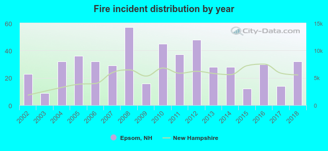 According to the data from the years 2002 - 2018 the average number of fires per year is 30. The highest number of reported fire incidents - 57 took place in 2008, and the least - 9 in 2003. The data has a growing trend.
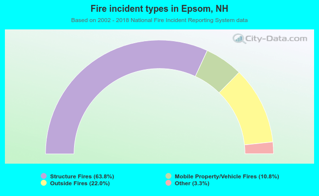 When looking into fire subcategories, the most reports belonged to: Structure Fires (63.8%), and Outside Fires (22.0%).
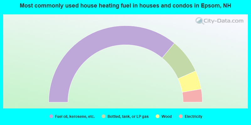
- 71.9%Fuel oil, kerosene, etc.
- 14.6%Bottled, tank, or LP gas
- 7.9%Wood
- 5.5%Electricity
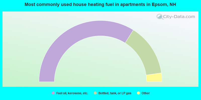
- 67.9%Fuel oil, kerosene, etc.
- 27.5%Bottled, tank, or LP gas
- 2.9%Other fuel
- 1.8%Electricity
Epsom compared to New Hampshire state average:
- Unemployed percentage significantly below state average.
- Black race population percentage below state average.
- Hispanic race population percentage significantly below state average.
- Foreign-born population percentage significantly below state average.
- Renting percentage below state average.
- Length of stay since moving in significantly above state average.
- Number of rooms per house significantly below state average.
- House age significantly below state average.
- Institutionalized population percentage above state average.

|
|
Total of 46 patent applications in 2008-2024.