Manchester-by-the-Sea, Massachusetts
Submit your own pictures of this town and show them to the world
- OSM Map
- Google Map
- MSN Map
Population change since 2000: -1.8%
 |
| Males: 2,406 | |
| Females: 2,730 |
| Median resident age: | 47.6 years |
| Massachusetts median age: | 39.2 years |
Zip codes: 01944.
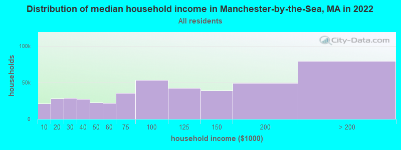
| Manchester-by-the-Sea: | $131,637 |
| MA: | $94,488 |
Estimated per capita income in 2022: $93,148 (it was $47,910 in 2000)
Manchester-by-the-Sea town income, earnings, and wages data
Estimated median house or condo value in 2022: over $1,000,000 (it was $418,800 in 2000)
| Manchester-by-the-Sea: | over $1,000,000 |
| MA: | $534,700 |
Mean prices in 2022: all housing units: $645,471; detached houses: $712,185; townhouses or other attached units: $551,275; in 2-unit structures: $503,219; in 3-to-4-unit structures: $450,535; in 5-or-more-unit structures: $352,534; mobile homes: $123,118; occupied boats, rvs, vans, etc.: $131,058
Manchester-by-the-Sea, MA residents, houses, and apartments details
Detailed information about poverty and poor residents in Manchester-by-the-Sea, MA

Compare current foreclosures near your location:
| Photo | Address | Area | Beds / Baths | Price | Details |
|---|---|---|---|---|---|

|
#1
S High St
Columbus, OH 43207
|
1,678 sq. feet
|
2 baths 4 beds |
$31,900
|
show details |

|
#2
Bayberry Cir
Columbus, OH 43207
|
1,564 sq. feet
|
1 baths 3 beds |
$127,500
|
show details |

|
#3
E 21st Ave
Columbus, OH 43211
|
1,061 sq. feet
|
1 baths 3 beds |
$187,900
|
show details |

|
#4
N Grener Ave
Columbus, OH 43228
|
1,120 sq. feet
|
1 baths 3 beds |
show details | |

|
#5
S Chillicothe St
Plain City, OH 43064
|
1,736 sq. feet
|
2 baths 4 beds |
show details | |

|
#6
Ferris Rd
Columbus, OH 43224
|
2,218 sq. feet
|
3 baths 3 beds |
show details | |

|
#7
High Free Pike
West Jefferson, OH 43162
|
1,216 sq. feet
|
2 baths 4 beds |
show details | |

|
#8
Mink St SW
Pataskala, OH 43062
|
1,442 sq. feet
|
1 baths 3 beds |
show details | |

|
#9
Meadowbrook Dr
Columbus, OH 43207
|
1,752 sq. feet
|
2 baths 4 beds |
show details | |

|
#10
Vineyard Haven Loop
Dublin, OH 43016
|
4,625 sq. feet
|
4 baths 4 beds |
show details |
| Photo | Address | Area | Beds / Baths | Price | Details |
|---|---|---|---|---|---|

|
#11
Falls Peak Ln
Delaware, OH 43015
|
1,352 sq. feet
|
2 baths 2 beds |
show details | |

|
#12
S Hague Ave
Columbus, OH 43204
|
979 sq. feet
|
1 baths 2 beds |
show details | |

|
#13
Striebel Ct
Columbus, OH 43227
|
925 sq. feet
|
1 baths 3 beds |
show details | |

|
#14
Wrexham Ave
Columbus, OH 43223
|
1,235 sq. feet
|
1 baths 3 beds |
show details | |

|
#15
Bunch Flower Ct
Westerville, OH 43082
|
3,173 sq. feet
|
2 baths 4 beds |
show details | |

|
#16
Kingsglen Dr
Grove City, OH 43123
|
1,635 sq. feet
|
2 baths 4 beds |
show details | |

|
#17
Midland Ave
Columbus, OH 43223
|
1,518 sq. feet
|
1 baths 2 beds |
show details | |

|
#18
Derrer Rd -872
Columbus, OH 43204
|
1,667 sq. feet
|
2 baths 5 beds |
show details | |

|
#19
Mayflower Blvd
Columbus, OH 43213
|
1,591 sq. feet
|
2 baths 4 beds |
show details | |

|
#20
Bretton Pl
Columbus, OH 43211
|
1,056 sq. feet
|
1 baths 3 beds |
show details |
| Photo | Address | Area | Beds / Baths | Price | Details |
|---|---|---|---|---|---|

|
#21
Trotter Dr
Columbus, OH 43207
|
1,478 sq. feet
|
1 baths 3 beds |
show details | |

|
#22
S Richardson Ave
Columbus, OH 43204
|
1,520 sq. feet
|
2 baths 3 beds |
show details | |

|
#23
Fergus Rd
Grove City, OH 43123
|
3,312 sq. feet
|
2 baths 4 beds |
show details | |

|
#24
Stoneybrook Blvd # 21a
Hilliard, OH 43026
|
1,231 sq. feet
|
2 baths 3 beds |
show details | |

|
#25
Hiawatha Park Dr
Columbus, OH 43211
|
1,278 sq. feet
|
1 baths 4 beds |
show details | |

|
#26
Edgeview Rd
Columbus, OH 43207
|
1,700 sq. feet
|
1 baths 4 beds |
show details | |

|
#27
Belle Oak Dr
Galloway, OH 43119
|
1,296 sq. feet
|
2 baths 3 beds |
show details | |

|
#28
Scottwood Rd
Columbus, OH 43227
|
1,008 sq. feet
|
1 baths 3 beds |
show details | |

|
#29
N Roys Ave
Columbus, OH 43204
|
1,248 sq. feet
|
2 baths 3 beds |
show details | |

|
#30
Elaine Rd
Columbus, OH 43213
|
764 sq. feet
|
1 baths 2 beds |
show details |
| Photo | Address | Area | Beds / Baths | Price | Details |
|---|---|---|---|---|---|

|
#31
Fahlander Dr N
Columbus, OH 43229
|
1,338 sq. feet
|
2 baths 3 beds |
show details | |

|
#32
Brookstone Dr
Westerville, OH 43082
|
1,783 sq. feet
|
3 baths 3 beds |
show details | |

|
#33
Rosewood Ct
Powell, OH 43065
|
2,801 sq. feet
|
3 baths 4 beds |
show details | |

|
#34
Sleeping Meadow Dr
New Albany, OH 43054
|
3,211 sq. feet
|
2 baths 4 beds |
show details | |

|
#35
Marshrun Dr
Grove City, OH 43123
|
2,036 sq. feet
|
2 baths 4 beds |
show details | |

|
#36
Bernadette Rd
Columbus, OH 43204
|
1,168 sq. feet
|
1 baths 3 beds |
show details | |

|
#37
Nantucket Ave
Columbus, OH 43235
|
1,864 sq. feet
|
2 baths 3 beds |
show details | |

|
#38
Messner Dr
Hilliard, OH 43026
|
832 sq. feet
|
1 baths 2 beds |
show details | |

|
#39
Saint James Ct
Columbus, OH 43220
|
1,314 sq. feet
|
1 baths 2 beds |
show details | |

|
#40
Falene Pl
Galloway, OH 43119
|
1,178 sq. feet
|
1 baths 3 beds |
show details |
| Photo | Address | Area | Beds / Baths | Price | Details |
|---|---|---|---|---|---|

|
#41
Wesson Dr
Columbus, OH 43232
|
1,200 sq. feet
|
1 baths 3 beds |
show details | |

|
#42
Ridgebury Dr
Hilliard, OH 43026
|
832 sq. feet
|
1 baths 2 beds |
show details | |

|
#43
Tea Party Pl
Columbus, OH 43207
|
1,176 sq. feet
|
2 baths 3 beds |
show details | |

|
#44
Legionary St
Columbus, OH 43207
|
1,356 sq. feet
|
2 baths 3 beds |
show details | |

|
#45
Barthel Ave
Columbus, OH 43227
|
1,276 sq. feet
|
1 baths 3 beds |
show details | |

|
#46
Pendent Ln
Columbus, OH 43207
|
1,260 sq. feet
|
2 baths 3 beds |
show details | |

|
#47
Bloomington Blvd
Columbus, OH 43228
|
1,940 sq. feet
|
2 baths 2 beds |
show details | |

|
#48
Oreily Dr
Galloway, OH 43119
|
1,533 sq. feet
|
2 baths 3 beds |
show details | |

|
#49
Walnut Creek Dr
Columbus, OH 43224
|
1,412 sq. feet
|
1 baths 3 beds |
show details | |

|
Check over 1 million property listings on Foreclosure.com!
|
browse all offers | |||

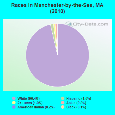
- 4,95296.4%White alone
- 761.5%Hispanic
- 491.0%Two or more races
- 410.8%Asian alone
- 110.2%American Indian alone
- 60.1%Black alone
- 10.02%Other race alone
Races in Manchester-by-the-Sea detailed stats: ancestries, foreign born residents, place of birth
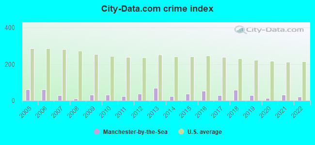
Type |
2009 |
2010 |
2011 |
2012 |
2013 |
2014 |
2015 |
2016 |
2017 |
2018 |
2019 |
2020 |
2021 |
2022 |
|---|---|---|---|---|---|---|---|---|---|---|---|---|---|---|
| Murders (per 100,000) | 0 (0.0) | 0 (0.0) | 0 (0.0) | 0 (0.0) | 0 (0.0) | 0 (0.0) | 0 (0.0) | 0 (0.0) | 0 (0.0) | 0 (0.0) | 0 (0.0) | 0 (0.0) | 0 (0.0) | 0 (0.0) |
| Rapes (per 100,000) | 1 (18.8) | 0 (0.0) | 0 (0.0) | 0 (0.0) | 1 (19.0) | 0 (0.0) | 0 (0.0) | 2 (37.1) | 1 (18.4) | 2 (36.8) | 0 (0.0) | 0 (0.0) | 0 (0.0) | 0 (0.0) |
| Robberies (per 100,000) | 0 (0.0) | 0 (0.0) | 0 (0.0) | 0 (0.0) | 0 (0.0) | 0 (0.0) | 0 (0.0) | 0 (0.0) | 0 (0.0) | 2 (36.8) | 0 (0.0) | 0 (0.0) | 0 (0.0) | 0 (0.0) |
| Assaults (per 100,000) | 1 (18.8) | 4 (77.9) | 2 (38.7) | 4 (76.6) | 8 (152.2) | 3 (56.7) | 5 (92.8) | 3 (55.7) | 1 (18.4) | 2 (36.8) | 2 (36.9) | 0 (0.0) | 4 (72.6) | 0 (0.0) |
| Burglaries (per 100,000) | 5 (93.8) | 6 (116.8) | 5 (96.8) | 2 (38.3) | 5 (95.1) | 1 (18.9) | 6 (111.4) | 2 (37.1) | 0 (0.0) | 2 (36.8) | 4 (73.8) | 0 (0.0) | 3 (54.4) | 1 (18.6) |
| Thefts (per 100,000) | 7 (131.3) | 9 (175.2) | 14 (271.0) | 24 (459.6) | 23 (437.7) | 14 (264.7) | 14 (259.9) | 12 (222.8) | 14 (257.6) | 8 (147.4) | 19 (350.4) | 16 (294.2) | 13 (235.8) | 26 (484.6) |
| Auto thefts (per 100,000) | 0 (0.0) | 1 (19.5) | 0 (0.0) | 0 (0.0) | 0 (0.0) | 0 (0.0) | 1 (18.6) | 1 (18.6) | 0 (0.0) | 1 (18.4) | 1 (18.4) | 1 (18.4) | 2 (36.3) | 1 (18.6) |
| Arson (per 100,000) | 0 (0.0) | 0 (0.0) | 1 (19.4) | 0 (0.0) | 0 (0.0) | 0 (0.0) | 0 (0.0) | 0 (0.0) | 0 (0.0) | 0 (0.0) | 0 (0.0) | 0 (0.0) | 0 (0.0) | 0 (0.0) |
| City-Data.com crime index | 30.6 | 32.3 | 25.4 | 36.4 | 69.8 | 23.3 | 38.2 | 53.8 | 28.7 | 57.8 | 28.0 | 13.2 | 30.7 | 22.2 |
The City-Data.com crime index weighs serious crimes and violent crimes more heavily. Higher means more crime, U.S. average is 246.1. It adjusts for the number of visitors and daily workers commuting into cities.
Crime rate in Manchester-by-the-Sea detailed stats: murders, rapes, robberies, assaults, burglaries, thefts, arson
Full-time law enforcement employees in 2021, including police officers: 32 (26 officers - 22 male; 4 female).
| Officers per 1,000 residents here: | 4.72 |
| Massachusetts average: | 2.53 |
 Recent articles from our blog. Our writers, many of them Ph.D. graduates or candidates, create easy-to-read articles on a wide variety of topics.

Ancestries: English (27.6%), Irish (26.7%), Italian (10.2%), German (9.1%), Scottish (6.4%), French (5.2%).
Current Local Time: EST time zone
Incorporated in 1645
Land area: 9.29 square miles.
Population density: 553 people per square mile (low).
263 residents are foreign born (3.7% Europe, 0.7% North America).
| This town: | 5.0% |
| Massachusetts: | 12.2% |
| Manchester-by-the-Sea town: | 0.9% ($3,686) |
| Massachusetts: | 1.3% ($2,336) |
Nearest city with pop. 50,000+: Lynn, MA  (12.1 miles , pop. 89,050).
Nearest city with pop. 200,000+: Boston, MA (24.3 miles , pop. 589,141).
Nearest city with pop. 1,000,000+: Bronx, NY (200.2 miles , pop. 1,332,650).
Nearest cities:
), Latitude: 42.58 N, Longitude: 70.77 W
Area code commonly used in this area: 978
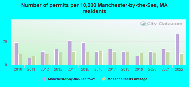
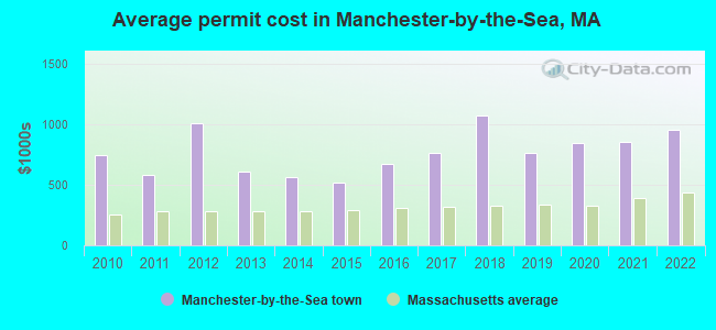
Single-family new house construction building permits:
- 2022: 14 buildings, average cost: $953,200
- 2021: 7 buildings, average cost: $855,000
- 2020: 6 buildings, average cost: $841,700
- 2019: 4 buildings, average cost: $767,500
- 2018: 6 buildings, average cost: $1,073,800
- 2017: 7 buildings, average cost: $761,400
- 2016: 6 buildings, average cost: $676,700
- 2015: 10 buildings, average cost: $520,800
- 2014: 11 buildings, average cost: $562,300
- 2013: 7 buildings, average cost: $606,400
- 2012: 6 buildings, average cost: $1,005,300
- 2011: 3 buildings, average cost: $578,300
- 2010: 10 buildings, average cost: $749,500
| Here: | 2.6% |
| Massachusetts: | 3.5% |
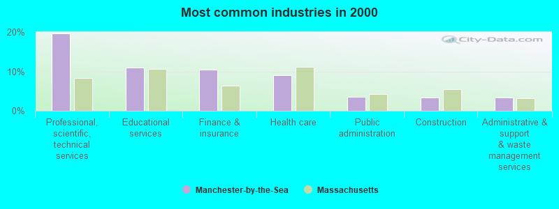
- Professional, scientific, technical services (19.6%)
- Educational services (10.9%)
- Finance & insurance (10.4%)
- Health care (9.0%)
- Public administration (3.6%)
- Construction (3.4%)
- Administrative & support & waste management services (3.3%)
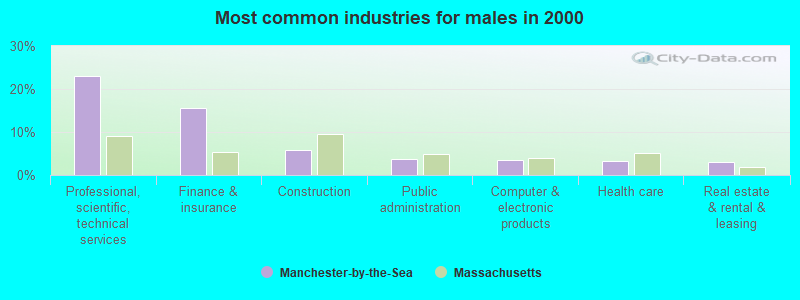
- Professional, scientific, technical services (23.0%)
- Finance & insurance (15.6%)
- Construction (5.8%)
- Public administration (3.6%)
- Computer & electronic products (3.6%)
- Health care (3.3%)
- Real estate & rental & leasing (3.0%)
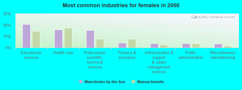
- Educational services (20.6%)
- Health care (15.9%)
- Professional, scientific, technical services (15.5%)
- Finance & insurance (4.3%)
- Administrative & support & waste management services (3.7%)
- Public administration (3.6%)
- Miscellaneous manufacturing (3.5%)

- Sales representatives, services, wholesale and manufacturing (9.2%)
- Top executives (7.5%)
- Other management occupations, except farmers and farm managers (5.2%)
- Other sales and related occupations, including supervisors (4.5%)
- Preschool, kindergarten, elementary, and middle school teachers (3.9%)
- Registered nurses (3.4%)
- Advertising, marketing, promotions, public relations, and sales managers (3.2%)
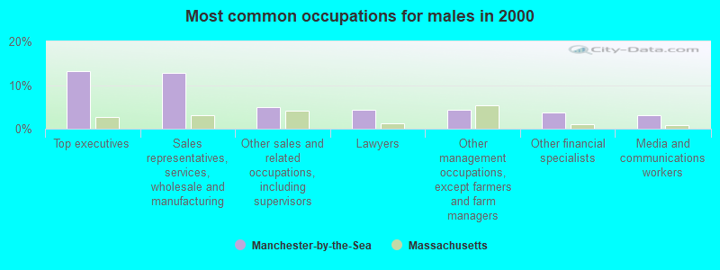
- Top executives (13.1%)
- Sales representatives, services, wholesale and manufacturing (12.8%)
- Other sales and related occupations, including supervisors (4.9%)
- Lawyers (4.4%)
- Other management occupations, except farmers and farm managers (4.3%)
- Other financial specialists (3.8%)
- Media and communications workers (3.1%)
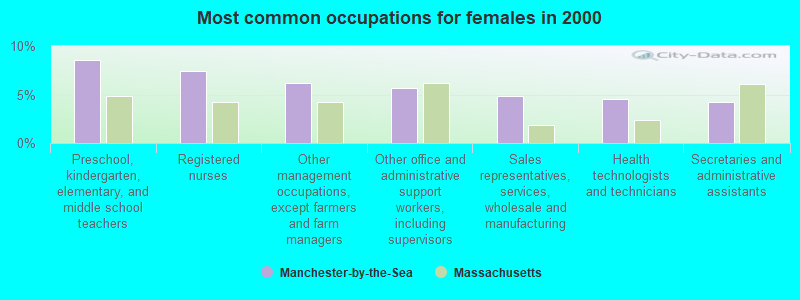
- Preschool, kindergarten, elementary, and middle school teachers (8.6%)
- Registered nurses (7.4%)
- Other management occupations, except farmers and farm managers (6.2%)
- Other office and administrative support workers, including supervisors (5.7%)
- Sales representatives, services, wholesale and manufacturing (4.9%)
- Health technologists and technicians (4.5%)
- Secretaries and administrative assistants (4.2%)
Average climate in Manchester-by-the-Sea, Massachusetts
Based on data reported by over 4,000 weather stations


(lower is better)
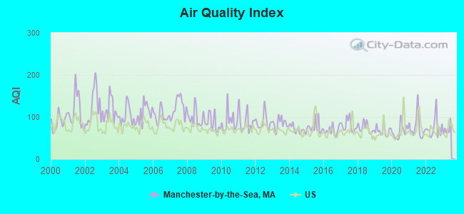
Air Quality Index (AQI) level in 2022 was 74.3. This is about average.
| City: | 74.3 |
| U.S.: | 72.6 |
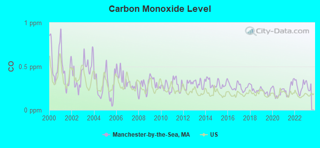
Carbon Monoxide (CO) [ppm] level in 2022 was 0.268. This is about average. Closest monitor was 19.3 miles away from the city center.
| City: | 0.268 |
| U.S.: | 0.251 |
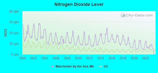
Nitrogen Dioxide (NO2) [ppb] level in 2022 was 7.78. This is significantly worse than average. Closest monitor was 7.3 miles away from the city center.
| City: | 7.78 |
| U.S.: | 5.11 |
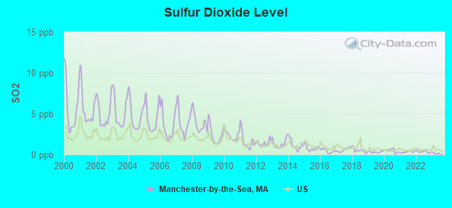
Sulfur Dioxide (SO2) [ppb] level in 2022 was 0.358. This is significantly better than average. Closest monitor was 4.1 miles away from the city center.
| City: | 0.358 |
| U.S.: | 1.515 |
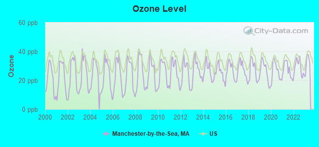
Ozone [ppb] level in 2022 was 28.9. This is about average. Closest monitor was 4.1 miles away from the city center.
| City: | 28.9 |
| U.S.: | 33.3 |
Particulate Matter (PM2.5) [µg/m3] level in 2022 was 6.60. This is better than average. Closest monitor was 12.7 miles away from the city center.
| City: | 6.60 |
| U.S.: | 8.11 |
Tornado activity:
Manchester-by-the-Sea-area historical tornado activity is slightly below Massachusetts state average. It is 55% smaller than the overall U.S. average.
On 9/29/1974, a category F3 (max. wind speeds 158-206 mph) tornado 22.3 miles away from the Manchester-by-the-Sea town center injured one person and caused between $50,000 and $500,000 in damages.
On 6/9/1953, a category F4 (max. wind speeds 207-260 mph) tornado 43.1 miles away from the town center killed 90 people and injured 1228 people and caused between $50,000,000 and $500,000,000 in damages.
Earthquake activity:
Manchester-by-the-Sea-area historical earthquake activity is significantly above Massachusetts state average. It is 74% smaller than the overall U.S. average.On 10/16/2012 at 23:12:25, a magnitude 4.7 (4.7 ML, Depth: 10.0 mi, Class: Light, Intensity: IV - V) earthquake occurred 70.7 miles away from Manchester-by-the-Sea center
On 4/20/2002 at 10:50:47, a magnitude 5.3 (5.3 ML, Depth: 3.0 mi, Class: Moderate, Intensity: VI - VII) earthquake occurred 198.7 miles away from the city center
On 1/19/1982 at 00:14:42, a magnitude 4.7 (4.5 MB, 4.7 MD, 4.5 LG) earthquake occurred 76.4 miles away from Manchester-by-the-Sea center
On 10/7/1983 at 10:18:46, a magnitude 5.3 (5.1 MB, 5.3 LG, 5.1 ML) earthquake occurred 203.7 miles away from the city center
On 4/20/2002 at 10:50:47, a magnitude 5.2 (5.2 MB, 4.2 MS, 5.2 MW, 5.0 MW) earthquake occurred 198.3 miles away from the city center
On 8/22/1992 at 12:20:32, a magnitude 4.8 (4.8 MB, 3.8 MS, 4.7 LG, Depth: 6.2 mi) earthquake occurred 241.3 miles away from the city center
Magnitude types: regional Lg-wave magnitude (LG), body-wave magnitude (MB), duration magnitude (MD), local magnitude (ML), surface-wave magnitude (MS), moment magnitude (MW)
Natural disasters:
The number of natural disasters in Essex County (33) is a lot greater than the US average (15).Major Disasters (Presidential) Declared: 20
Emergencies Declared: 13
Causes of natural disasters: Floods: 14, Storms: 11, Hurricanes: 6, Snowstorms: 5, Winter Storms: 5, Snows: 3, Blizzards: 2, Fire: 1, Heavy Rain: 1, Snowfall: 1, Water Main Break: 1, Wind: 1 (Note: some incidents may be assigned to more than one category).
Hospitals and medical centers near Manchester-by-the-Sea:
- ESSEX PARK REHABILITATION AND NURSING CENTER (Nursing Home, about 6 miles away; BEVERLY, MA)
- MEDIPLEX OF BEVERLY LTCF (Nursing Home, about 6 miles away; BEVERLY, MA)
- ADDISON GILBERT HOSPITAL (Hospital, about 6 miles away; GLOUCESTER, MA)
- SEACOAST NURSING AND REHABILITATION CENTER INC (Nursing Home, about 6 miles away; GLOUCESTER, MA)
- GOLDEN LIVING CENTER-GLOUCESTER (Nursing Home, about 6 miles away; GLOUCESTER, MA)
- GREYCLIFF AT CAPE ANN CONV CTR (Nursing Home, about 6 miles away; GLOUCESTER, MA)
- BLUEBERYHILL HEALTHCARE N H (Nursing Home, about 6 miles away; BEVERLY, MA)
Colleges/universities with over 2000 students nearest to Manchester-by-the-Sea:
- Endicott College (about 5 miles; Beverly, MA; Full-time enrollment: 4,064)
- Salem State University (about 9 miles; Salem, MA; FT enrollment: 8,027)
- North Shore Community College (about 11 miles; Danvers, MA; FT enrollment: 5,195)
- Merrimack College (about 20 miles; North Andover, MA; FT enrollment: 2,734)
- Northern Essex Community College (about 21 miles; Haverhill, MA; FT enrollment: 4,737)
- Bunker Hill Community College (about 21 miles; Boston, MA; FT enrollment: 8,814)
- Suffolk University (about 22 miles; Boston, MA; FT enrollment: 6,982)
Points of interest:
Notable locations in Manchester-by-the-Sea: Essex Country Club (A), Manchester Station (B), Trask House Museum (C), Manchester Fire Department (D). Display/hide their locations on the map
Churches in Manchester-by-the-Sea include: Rosedale Church (A), First Parish Church (B), First Baptist Church (C). Display/hide their locations on the map
Cemeteries: Union Cemetery (1), Rosedale Cemetery (2). Display/hide their locations on the map
Lakes and swamps: Dexter Pond (A), Clark Pond (B), Cedar Swamp (C), Millets Swamp (D), Bayberry Swamp (E), Beaverdam Swamp (F). Display/hide their locations on the map
Streams, rivers, and creeks: Causeway Brook (A), Sawmill Brook (B), Cat Brook (C), Wolf Trap Branch (D). Display/hide their locations on the map
Park in Manchester-by-the-Sea: Masconomo Park (1). Display/hide its location on the map
Beaches: Gray Beach (A), Black Beach (B). Display/hide their locations on the map
Birthplace of: Jesse Robbins - Entrepreneur, Sprague Grayden - Actress.
| This town: | 2.4 people |
| Massachusetts: | 2.5 people |
| This town: | 67.3% |
| Whole state: | 63.0% |
| This town: | 4.3% |
| Whole state: | 7.0% |
Likely homosexual households (counted as self-reported same-sex unmarried-partner households)
- Lesbian couples: 0.5% of all households
- Gay men: 0.2% of all households
| This town: | 4.8% |
| Whole state: | 9.3% |
| This town: | 2.2% |
| Whole state: | 4.4% |
18 people in nursing homes in 2000
For population 15 years and over in Manchester-by-the-Sea:
- Never married: 22.4%
- Now married: 58.2%
- Separated: 1.6%
- Widowed: 8.0%
- Divorced: 9.7%
For population 25 years and over in Manchester-by-the-Sea:
- High school or higher: 96.0%
- Bachelor's degree or higher: 56.0%
- Graduate or professional degree: 22.1%
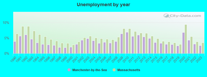
- Unemployed: 1.8%
- Mean travel time to work (commute): 31.8 minutes

| Here: | 9.8 |
| Massachusetts average: | 13.1 |


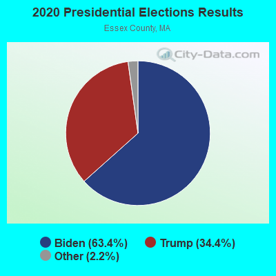
Graphs represent county-level data. Detailed 2008 Election Results
Political contributions by individuals in Manchester-by-the-Sea, MA
Religion statistics for Manchester-by-the-Sea, MA (based on Essex County data)


| Religion | Adherents | Congregations |
|---|---|---|
| Catholic | 341,970 | 55 |
| Mainline Protestant | 33,710 | 140 |
| Evangelical Protestant | 20,925 | 160 |
| Other | 15,882 | 63 |
| Orthodox | 11,590 | 13 |
| Black Protestant | 376 | 3 |
| None | 318,706 | - |
Food Environment Statistics:
| Here: | 1.98 / 10,000 pop. |
| State: | 1.98 / 10,000 pop. |
| Essex County: | 0.04 / 10,000 pop. |
| Massachusetts: | 0.05 / 10,000 pop. |
| Essex County: | 1.97 / 10,000 pop. |
| State: | 2.22 / 10,000 pop. |
| Here: | 1.30 / 10,000 pop. |
| State: | 1.77 / 10,000 pop. |
| Essex County: | 7.60 / 10,000 pop. |
| Massachusetts: | 8.76 / 10,000 pop. |
| Essex County: | 8.4% |
| State: | 8.1% |
| This county: | 23.7% |
| State: | 22.5% |
| This county: | 20.7% |
| State: | 16.5% |
5.09% of this county's 2021 resident taxpayers lived in other counties in 2020 ($96,821 average adjusted gross income)
| Here: | 5.09% |
| Massachusetts average: | 6.35% |
0.01% of residents moved from foreign countries ($21 average AGI)
Essex County: 0.01% Massachusetts average: 0.01%
Top counties from which taxpayers relocated into this county between 2020 and 2021:
| from Middlesex County, MA | |
| from Suffolk County, MA | |
| from Rockingham County, NH |
5.47% of this county's 2020 resident taxpayers moved to other counties in 2021 ($95,440 average adjusted gross income)
| Here: | 5.47% |
| Massachusetts average: | 7.18% |
0.01% of residents moved to foreign countries ($53 average AGI)
Essex County: 0.01% Massachusetts average: 0.02%
Top counties to which taxpayers relocated from this county between 2020 and 2021:
| to Middlesex County, MA | |
| to Rockingham County, NH | |
| to Suffolk County, MA |
Strongest AM radio stations in Manchester-by-the-Sea:
- WRKO (680 AM; 50 kW; BOSTON, MA; Owner: ENTERCOM BOSTON LICENSE, LLC)
- WBZ (1030 AM; 50 kW; BOSTON, MA; Owner: INFINITY BROADCASTING OPERATIONS, INC.)
- WEEI (850 AM; 50 kW; BOSTON, MA; Owner: ENTERCOM BOSTON LICENSE, LLC)
- WWZN (1510 AM; 50 kW; BOSTON, MA; Owner: ROSE CITY RADIO CORPORATION)
- WNSH (1570 AM; 5 kW; BEVERLY, MA)
- WKOX (1200 AM; 50 kW; FRAMINGHAM, MA; Owner: CAPSTAR TX LIMITED PARTNERSHIP)
- WBIX (1060 AM; 40 kW; NATICK, MA; Owner: LANGER BROADCASTING CORPORATION)
- WROL (950 AM; 5 kW; BOSTON, MA; Owner: SCA LICENSE CORPORATION)
- WRCA (1330 AM; 25 kW; WALTHAM, MA; Owner: WRCA LICENSE, LLC)
- WESX (1230 AM; 1 kW; SALEM, MA; Owner: NORTH SHORE BROADCASTING CORP.)
- WEZE (590 AM; 5 kW; BOSTON, MA; Owner: NEW ENGLAND CONTINENTAL MEDIA, INC.)
- WAMG (890 AM; 25 kW; DEDHAM, MA; Owner: MEGA COMMUNICATIONS OF DEDHAM LICENSEE, LLC)
- WUNR (1600 AM; 20 kW; BROOKLINE, MA; Owner: CHAMPION BROADCASTING SYSTEMS, INC.)
Strongest FM radio stations in Manchester-by-the-Sea:
- WBOQ (104.9 FM; GLOUCESTER, MA; Owner: MARLIN BROADCASTING, LLC)
- WQSX (93.7 FM; LAWRENCE, MA; Owner: ENTERCOM BOSTON LICENSE, LLC)
- WXKS-FM (107.9 FM; MEDFORD, MA; Owner: AMFM RADIO LICENSES, L.L.C.)
- WMJX (106.7 FM; BOSTON, MA; Owner: GREATER BOSTON RADIO, INC.)
- WBMX (98.5 FM; BOSTON, MA; Owner: INFINITY RADIO OPERATIONS INC.)
- WJMN (94.5 FM; BOSTON, MA; Owner: AMFM RADIO LICENSES, L.L.C.)
- WBOS (92.9 FM; BROOKLINE, MA; Owner: GREATER BOSTON RADIO, INC.)
- WCRB (102.5 FM; WALTHAM, MA; Owner: CHARLES RIVER BROADCASTING WCRB LICE)
- WTKK (96.9 FM; BOSTON, MA; Owner: GREATER BOSTON RADIO, INC.)
- WROR-FM (105.7 FM; FRAMINGHAM, MA; Owner: GREATER BOSTON RADIO, INC.)
- W267AI (101.3 FM; BOSTON, MA; Owner: MCC BROADCASTING COMPANY, INC.)
- WBCN (104.1 FM; BOSTON, MA; Owner: HEMISPHERE BROADCASTING CORPORATION)
- WZLX (100.7 FM; BOSTON, MA; Owner: INFINITY BROADCASTING CORPORATION OF BOSTON)
- WXRV (92.5 FM; HAVERHILL, MA; Owner: BEANPOT BROADCASTING CORP.)
- WERS (88.9 FM; BOSTON, MA; Owner: EMERSON COLLEGE)
- WGBH (89.7 FM; BOSTON, MA; Owner: WGBH EDUCATIONAL FOUNDATION)
- WBUR-FM (90.9 FM; BOSTON, MA; Owner: TRUSTEES OF BOSTON UNIVERSITY)
- WHRB (95.3 FM; CAMBRIDGE, MA; Owner: HARVARD RADIO BROADCASTING CO., INC.)
- WKLB-FM (99.5 FM; LOWELL, MA; Owner: GREATER BOSTON RADIO, INC.)
- WODS (103.3 FM; BOSTON, MA; Owner: INFINITY BROADCASTING OPERATIONS, INC.)
TV broadcast stations around Manchester-by-the-Sea:
- WCVB-TV (Channel 5; BOSTON, MA; Owner: WCVB HEARST-ARGYLE TV, INC.)
- WGBH-TV (Channel 2; BOSTON, MA; Owner: WGBH EDUCATIONAL FOUNDATION)
- WBPX (Channel 68; BOSTON, MA; Owner: PAXSON BOSTON-68 LICENSE, INC.)
- WHDH-TV (Channel 7; BOSTON, MA; Owner: WHDH-TV)
- WMFP (Channel 62; LAWRENCE, MA; Owner: WSAH LICENSE, INC.)
- WSBK-TV (Channel 38; BOSTON, MA; Owner: VIACOM INC.)
- WLVI-TV (Channel 56; CAMBRIDGE, MA; Owner: WLVI, INC.)
- WBZ-TV (Channel 4; BOSTON, MA; Owner: VIACOM INC.)
- WGBX-TV (Channel 44; BOSTON, MA; Owner: WGBH EDUCATIONAL FOUNDATION)
- WFXZ-CA (Channel 24; BOSTON, MA; Owner: BOSTON BROADCASTING CORP.)
- WTMU-LP (Channel 32; BOSTON, MA; Owner: ZGS BOSTON, INC.)
- WFXT (Channel 25; BOSTON, MA; Owner: FOX TELEVISION STATIONS INC.)
- WCEA-LP (Channel 58; BOSTON, MA; Owner: CHANNEL 19 TV CORPORATION)
- WHDN-LP (Channel 26; BOSTON, MA; Owner: GUENTER MARKSTEINER)
- W40BO (Channel 40; BOSTON, MA; Owner: PAXSON COMMUNICATIONS LPTV, INC.)
- WUTF (Channel 66; MARLBOROUGH, MA; Owner: TELEFUTURA BOSTON LLC)
- WWDP (Channel 46; NORWELL, MA; Owner: NORWELL TELEVISION, LLC)
- WUNI (Channel 27; WORCESTER, MA; Owner: ENTRAVISION HOLDINGS, LLC)
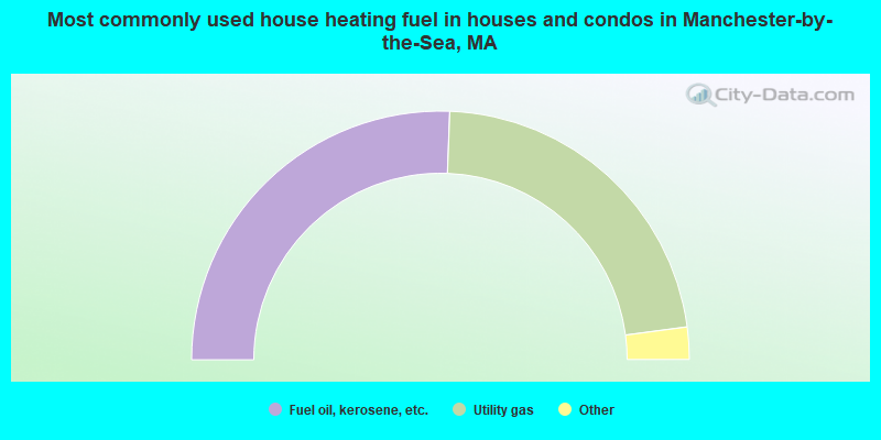
- 51.2%Fuel oil, kerosene, etc.
- 44.6%Utility gas
- 2.3%Electricity
- 1.8%Bottled, tank, or LP gas
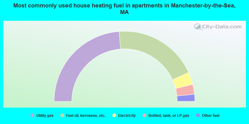
- 47.6%Utility gas
- 38.9%Fuel oil, kerosene, etc.
- 5.7%Electricity
- 4.6%Bottled, tank, or LP gas
- 3.2%Other fuel
Manchester-by-the-Sea compared to Massachusetts state average:
- Median house value above state average.
- Unemployed percentage significantly below state average.
- Black race population percentage significantly below state average.
- Hispanic race population percentage significantly below state average.
- Median age significantly above state average.
- Foreign-born population percentage significantly below state average.
- Length of stay since moving in significantly above state average.
- Number of rooms per house significantly below state average.
- House age significantly below state average.
- Percentage of population with a bachelor's degree or higher above state average.
Manchester-by-the-Sea on our top lists:
- #1 on the list of "Top 101 cities with largest percentage of males in occupations: sales representatives, services, wholesale and manufacturing (population 5,000+)"
- #4 on the list of "Top 101 cities with largest percentage of males in occupations: top executives (population 5,000+)"
- #4 on the list of "Top 101 cities with largest percentage of females in industries: machinery, equipment, and supplies merchant wholesalers (population 5,000+)"
- #9 on the list of "Top 101 cities with largest percentage of females in occupations: advertising, marketing, promotions, public relations, and sales managers (population 5,000+)"
- #10 on the list of "Top 101 cities with largest percentage of males in occupations: customer service representatives (population 5,000+)"
- #10 on the list of "Top 101 cities with largest percentage of males in industries: petroleum and petroleum products merchant wholesalers (population 5,000+)"
- #14 on the list of "Top 101 cities with largest percentage of males in industries: professional and commercial equipment and supplies merchant wholesalers (population 5,000+)"
- #14 on the list of "Top 101 cities with largest percentage of males in occupations: media and communication equipment workers (population 5,000+)"
- #15 on the list of "Top 101 cities with largest percentage of females in occupations: printing workers (population 5,000+)"
- #18 on the list of "Top 101 cities with largest percentage of males in industries: miscellaneous nondurable goods merchant wholesalers (population 5,000+)"
- #29 on the list of "Top 101 cities with largest percentage of males in industries: vending machine operators (population 5,000+)"
- #30 on the list of "Top 101 cities with largest percentage of males in industries: alcoholic beverages merchant wholesalers (population 5,000+)"
- #31 on the list of "Top 101 cities with the highest cost per building permit(population 5,000+)"
- #33 on the list of "Top 101 cities with the lowest number of burglaries per 100,000 residents (population 5,000+)"
- #34 on the list of "Top 101 cities with largest percentage of males in industries: publishing, and motion picture and sound recording industries (population 5,000+)"
- #36 on the list of "Top 101 cities with largest percentage of males in industries: electrical and electronic goods merchant wholesalers (population 5,000+)"
- #36 on the list of "Top 101 cities with largest percentage of females in industries: printing and related support activities (population 5,000+)"
- #50 on the list of "Top 101 cities with largest percentage of females in industries: apparel, fabrics, and notions merchant wholesalers (population 5,000+)"
- #50 on the list of "Top 101 cities with the smallest city-data.com crime index per police officer (population 5,000+)"
- #52 on the list of "Top 101 cities with largest percentage of males in industries: paper and paper products merchant wholesalers (population 5,000+)"
- #21 on the list of "Top 101 counties with the lowest percentage of residents that keep firearms around their homes"
- #21 on the list of "Top 101 counties with the most Orthodox adherents"
- #23 on the list of "Top 101 counties with the highest carbon monoxide air pollution readings in 2012 (ppm)"
- #30 on the list of "Top 101 counties with the most Catholic adherents"
- #36 on the list of "Top 101 counties with the most Orthodox congregations (pop. 50,000+)"