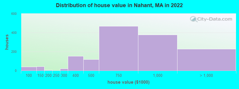
Estimated median house or condo value in 2022: $702,862 (it was $286,500 in 2000)
Nahant:
$702,862
MA:
$534,700
Mean prices in 2022:all housing units: $645,471; detached houses: $712,185; townhouses or other attached units: $551,275; in 2-unit structures: $503,219; in 3-to-4-unit structures: $450,535; in 5-or-more-unit structures: $352,534; mobile homes: $123,118; occupied boats, rvs, vans, etc.: $131,058
Median gross rent in 2022: $1,873.
March 2022 cost of living index in Nahant: 138.7 (high, U.S. average is 100)
According to our research of Massachusetts and other state lists, there was 1 registered sex offender living in Nahant, Massachusetts as of April 26, 2024. The ratio of all residents to sex offenders in Nahant is 3,514 to 1. The ratio of registered sex offenders to all residents in this city is lower than the state average.
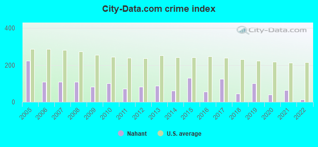
Crime rates in Nahant by year
Type
2009
2010
2011
2012
2013
2014
2015
2016
2017
2018
2019
2020
2021
2022
Murders (per 100,000)
0 (0.0)
0 (0.0)
0 (0.0)
0 (0.0)
0 (0.0)
0 (0.0)
0 (0.0)
0 (0.0)
0 (0.0)
0 (0.0)
0 (0.0)
0 (0.0)
0 (0.0)
0 (0.0)
Rapes (per 100,000)
0 (0.0)
0 (0.0)
0 (0.0)
0 (0.0)
1 (28.9)
0 (0.0)
3 (85.8)
0 (0.0)
1 (28.6)
0 (0.0)
1 (28.5)
0 (0.0)
1 (28.2)
0 (0.0)
Robberies (per 100,000)
0 (0.0)
0 (0.0)
0 (0.0)
0 (0.0)
0 (0.0)
0 (0.0)
0 (0.0)
0 (0.0)
1 (28.6)
1 (28.5)
0 (0.0)
1 (28.5)
0 (0.0)
0 (0.0)
Assaults (per 100,000)
6 (169.1)
7 (205.3)
4 (116.6)
6 (173.1)
7 (202.3)
6 (173.2)
5 (143.0)
4 (114.8)
10 (285.7)
5 (142.3)
11 (313.3)
3 (85.6)
5 (141.1)
1 (30.2)
Burglaries (per 100,000)
10 (281.8)
13 (381.2)
10 (291.5)
9 (259.6)
4 (115.6)
4 (115.5)
10 (286.0)
3 (86.1)
5 (142.9)
1 (28.5)
2 (57.0)
1 (28.5)
0 (0.0)
0 (0.0)
Thefts (per 100,000)
23 (648.3)
22 (645.2)
25 (728.7)
25 (721.1)
13 (375.6)
15 (433.0)
11 (314.6)
20 (574.1)
20 (571.4)
6 (170.8)
9 (256.3)
11 (313.8)
9 (254.0)
7 (211.2)
Auto thefts (per 100,000)
1 (28.2)
3 (88.0)
0 (0.0)
0 (0.0)
1 (28.9)
1 (28.9)
0 (0.0)
2 (57.4)
2 (57.1)
0 (0.0)
1 (28.5)
0 (0.0)
1 (28.2)
0 (0.0)
Arson (per 100,000)
0 (0.0)
0 (0.0)
0 (0.0)
1 (28.8)
0 (0.0)
0 (0.0)
1 (28.6)
0 (0.0)
1 (28.6)
0 (0.0)
0 (0.0)
0 (0.0)
0 (0.0)
0 (0.0)
City-Data.com crime index
81.7
100.6
72.9
81.6
89.0
62.4
129.9
56.5
126.0
45.8
102.0
40.2
63.2
14.5
The City-Data.com crime index weighs serious crimes and violent crimes more heavily. Higher means more crime, U.S. average is 246.1. It adjusts for the number of visitors and daily workers commuting into cities.
Latest news from Nahant, MA collected exclusively by city-data.com from local newspapers, TV, and radio stations
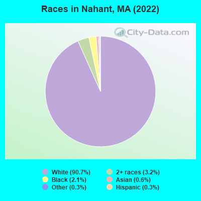
Ancestries: Irish (20.0%), Italian (14.6%), English (12.9%), Northern European (8.0%), American (7.0%), Greek (4.8%).
Current Local Time: EST time zone
Incorporated in 1853
Elevation: 50 feet
Land area: 1.24 square miles.
Population density: 2,740 people per square mile (average).
217 residents are foreign born (2.5% Europe, 1.8% North America, 1.1% Asia, 0.9% Latin America).
This place:
6.5%
Massachusetts:
17.6%
Median real estate property taxes paid for housing units with mortgages in 2022: $5,860 (0.8%) Median real estate property taxes paid for housing units with no mortgage in 2022: $6,352 (0.8%)
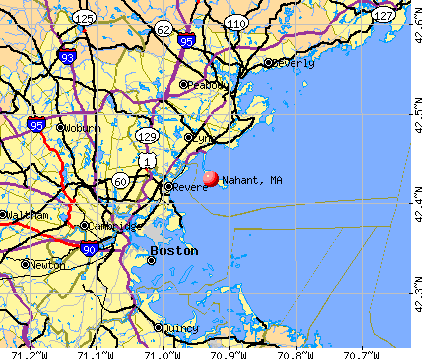
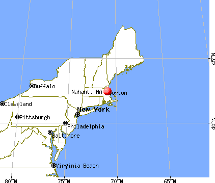
Nearest city with pop. 50,000+: Lynn, MA (3.5 miles , pop. 89,050).
Nearest city with pop. 200,000+: Boston, MA (11.0 miles , pop. 589,141).
Nearest city with pop. 1,000,000+: Bronx, NY (187.4 miles , pop. 1,332,650).
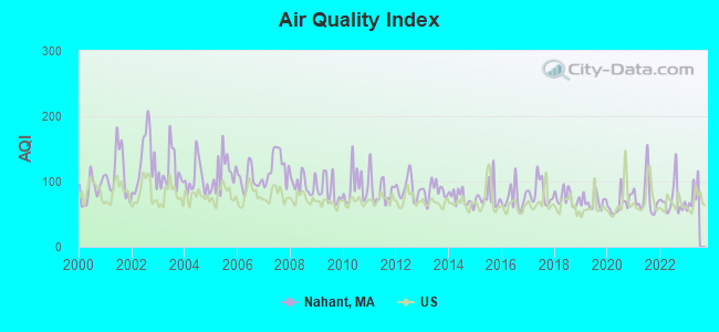
Air Quality Index (AQI) level in 2022 was 71.9. This is about average.
City:
71.9
U.S.:
72.6
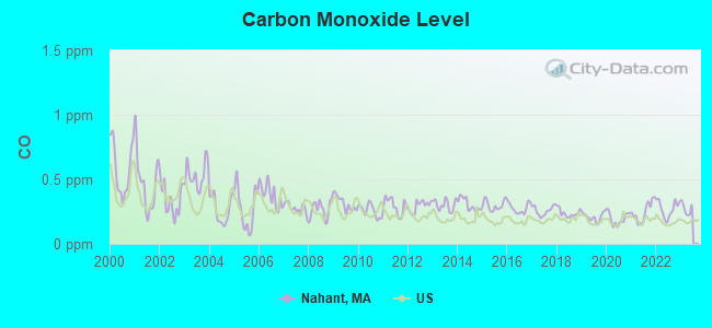
Carbon Monoxide (CO) [ppm] level in 2022 was 0.270. This is about average.Closest monitor was 6.1 miles away from the city center.
City:
0.270
U.S.:
0.251
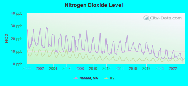
Nitrogen Dioxide (NO2) [ppb] level in 2022 was 6.77. This is worse than average.Closest monitor was 2.9 miles away from the city center.
City:
6.77
U.S.:
5.11
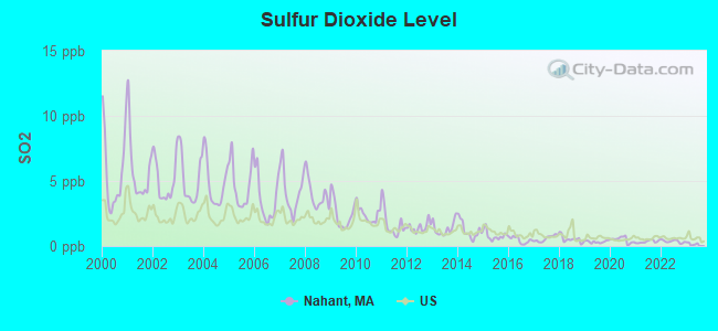
Sulfur Dioxide (SO2) [ppb] level in 2022 was 0.358. This is significantly better than average.Closest monitor was 2.2 miles away from the city center.
City:
0.358
U.S.:
1.515
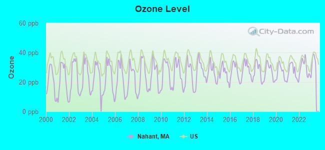
Ozone [ppb] level in 2022 was 29.8. This is about average.Closest monitor was 5.5 miles away from the city center.
City:
29.8
U.S.:
33.3
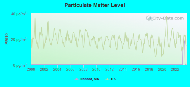
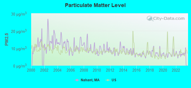
Particulate Matter (PM2.5) [µg/m3] level in 2022 was 6.47. This is better than average.Closest monitor was 3.9 miles away from the city center.
City:
6.47
U.S.:
8.11
Tornado activity:
Nahant-area historical tornado activity is slightly below Massachusetts state average. It is 50% smaller than the overall U.S. average.
On 6/9/1953, a category F4 (max. wind speeds 207-260 mph) tornado 31.5 miles away from the Nahant place center killed 90 peopleand injured 1228 peopleand causedbetween $50,000,000 and $500,000,000 in damages.
On 9/29/1974, a category F3 (max. wind speeds 158-206 mph) tornado 19.2 miles away from the place center injured one personand causedbetween $50,000 and $500,000 in damages.
Earthquake activity:
Nahant-area historical earthquake activity is significantly above Massachusetts state average. It is 74% smaller than the overall U.S. average.
On 4/20/2002 at 10:50:47, a magnitude 5.3 (5.3 ML, Depth: 3.0 mi, Class: Moderate, Intensity: VI - VII) earthquake occurred 200.3 miles away from the city center On 10/7/1983 at 10:18:46, a magnitude 5.3 (5.1 MB, 5.3 LG, 5.1 ML) earthquake occurred 201.9 miles away from the city center On 1/19/1982 at 00:14:42, a magnitude 4.7 (4.5 MB, 4.7 MD, 4.5 LG, Class: Light, Intensity: IV - V) earthquake occurred 81.6 miles away from Nahant center On 10/16/2012 at 23:12:25, a magnitude 4.7 (4.7 ML, Depth: 10.0 mi) earthquake occurred 82.1 miles away from Nahant center On 4/20/2002 at 10:50:47, a magnitude 5.2 (5.2 MB, 4.2 MS, 5.2 MW, 5.0 MW) earthquake occurred 199.8 miles away from Nahant center On 8/22/1992 at 12:20:32, a magnitude 4.8 (4.8 MB, 3.8 MS, 4.7 LG, Depth: 6.2 mi) earthquake occurred 231.9 miles away from Nahant center Magnitude types: regional Lg-wave magnitude (LG), body-wave magnitude (MB), duration magnitude (MD), local magnitude (ML), surface-wave magnitude (MS), moment magnitude (MW)
Natural disasters:
The number of natural disasters in Essex County (33) is a lot greater than the US average (15). Major Disasters (Presidential) Declared: 20 Emergencies Declared: 13
Causes of natural disasters: Floods: 14, Storms: 11, Hurricanes: 6, Snowstorms: 5, Winter Storms: 5, Snows: 3, Blizzards: 2, Fire: 1, Heavy Rain: 1, Snowfall: 1, Water Main Break: 1, Wind: 1 (Note: some incidents may be assigned to more than one category).
Hospitals and medical centers in Nahant:
JESMOND NURSING HOME (271 NAHANT ROAD)
Other hospitals and medical centers near Nahant:
CRESTVIEW MANOR NURSING HOME I (Nursing Home, about 3 miles away; LYNN, MA)
NEIGHBORHOOD HOME CARE LLC (Home Health Center, about 3 miles away; LYNN, MA)
ALL CARE VNA-GREATER LYNN INC (Home Health Center, about 3 miles away; LYNN, MA)
ALL CARE HOSPICE INC (Hospital, about 3 miles away; LYNN, MA)
OAK ISLAND SKILLED NURSING CTR (Nursing Home, about 3 miles away; REVERE, MA)
AVALON N H (Nursing Home, about 3 miles away; LYNN, MA)
ANN CARROLL NURSING HOME (Nursing Home, about 3 miles away; LYNN, MA)
Amtrak stations near Nahant:
9 miles: BOSTON, NORTH STATION (BOSTON, 126 CAUSEWAY ST.) . Services: ticket office, enclosed waiting area.
9 miles: BOSTON (SO. STA) (BOSTON, ATLANTIC AVE. & SUMMER ST.) . Services: ticket office, fully wheelchair accessible, enclosed waiting area, public restrooms, public payphones, full-service food facilities and snack bar, ATM, paid short-term parking, paid long-term parking, call for car rental service, taxi stand, intercity bus service, public transit connection.
10 miles: BACK BAY (BOSTON, 145 DARTMOUTH ST.) . Services: ticket office, partially wheelchair accessible, enclosed waiting area, public restrooms, public payphones, vending machines, ATM, paid short-term parking, paid long-term parking, call for car rental service, taxi stand, public transit connection.
Colleges/universities with over 2000 students nearest to Nahant:
Salem State University (about 6 miles; Salem, MA; Full-time enrollment: 8,027)
Bunker Hill Community College (about 9 miles; Boston, MA; FT enrollment: 8,814)
Suffolk University (about 9 miles; Boston, MA; FT enrollment: 6,982)
Emerson College (about 9 miles; Boston, MA; FT enrollment: 4,657)
Massachusetts Institute of Technology (about 10 miles; Cambridge, MA; FT enrollment: 13,548)
University of Massachusetts-Boston (about 10 miles; Boston, MA; FT enrollment: 12,625)
Berklee College of Music (about 10 miles; Boston, MA; FT enrollment: 4,726)
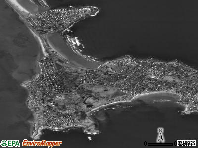
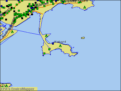
Notable locations in Nahant: Kelly Green Golf Course (A), Sandy Point Light (B), Black Marsh Channel Light (C), Upper Turn Light (D), Nahant Townhall (E), Nahant Fire Department (F). Display/hide their locations on the map
Hotel: Selective Hotel Reservation (44 Pond Street).
Birthplace of: Henry Cabot Lodge, Jr. - Politician, Barbra Fuller - Film actor, William F. Johnson - Politician.
Essex County has a predicted average indoor radon screening level greater than 4 pCi/L (pico curies per liter) - Highest Potential
Drinking water stations with addresses in Nahant and their reported violations in the past:
NAHANT WATER DEPT. (MWRA) (Population served: 3,700, Purch surface water):
Past monitoring violations:
Initial Tap Sampling for Pb and Cu - In JUL-01-1992, Contaminant: Lead and Copper Rule
Average household size:
This place:
2.2 people
Massachusetts:
2.5 people
Percentage of family households:
This place:
59.8%
Whole state:
63.0%
Percentage of households with unmarried partners:
This place:
5.9%
Whole state:
7.0%
Likely homosexual households (counted as self-reported same-sex unmarried-partner households)
Lesbian couples: 0.6% of all households
Gay men: 0.3% of all households
54 people in nursing facilities/skilled-nursing facilities in 2010
55 people in nursing homes in 2000
Banks with branches in Nahant (2011 data):
Equitable Co-operative Bank: Nahant Branch at 28 Nahant Road, branch established on 1996/06/17. Info updated 2010/01/11: Bank assets: $101.4 mil, Deposits: $79.2 mil, headquarters in Lynn, MA, positive income, Mortgage Lending Specialization, 2 total offices
Religion statistics for Nahant, MA (based on Essex County data)
Religion
Adherents
Congregations
Catholic
341,970
55
Mainline Protestant
33,710
140
Evangelical Protestant
20,925
160
Other
15,882
63
Orthodox
11,590
13
Black Protestant
376
3
None
318,706
-
Source: Clifford Grammich, Kirk Hadaway, Richard Houseal, Dale E.Jones, Alexei Krindatch, Richie Stanley and Richard H.Taylor. 2012. 2010 U.S.Religion Census: Religious Congregations & Membership Study. Association of Statisticians of American Religious Bodies. Jones, Dale E., et al. 2002. Congregations and Membership in the United States 2000. Nashville, TN: Glenmary Research Center. Graphs represent county-level data
East Point (Lat: 42.418694 Lon: -70.907278), Type: Building, Overall height: 14 m, Call Sign: WRV308, Licensee ID: L00021677, Assigned Frequencies: 156.450 MHz, 156.800 MHz, Grant Date: 07/26/2000, Expiration Date: 07/06/2005, Cancellation Date: 01/07/2006, Registrant: Northeastern University Marine Science Center, East Point, Nahant, MA 01908
Aircraft: ROLLADEN-SCHNEIDER LS8-18 (Category: Land, Weight: Up to 12,499 Pounds), Engine: None N-Number: 818JK, N818JK, N-818JK, Serial Number: 8344, Year manufactured: 2000, Airworthiness Date: 02/24/2001, Certificate Issue Date: 11/27/2013 Registrant (Individual): Harry W Detrich, 10 Valley Rd, Nahant, MA 01908
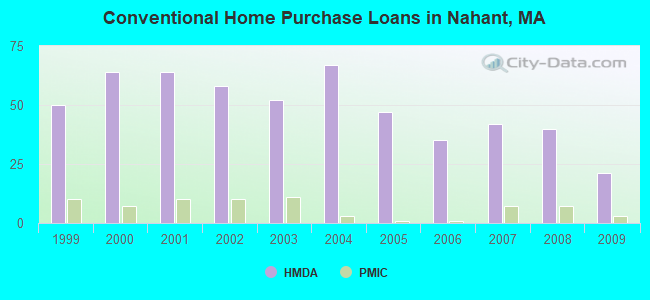
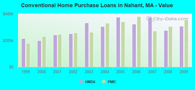
Home Mortgage Disclosure Act Aggregated Statistics For Year 2009 (Based on 1 full tract)
A) FHA, FSA/RHS & VA Home Purchase Loans
B) Conventional Home Purchase Loans
C) Refinancings
D) Home Improvement Loans
F) Non-occupant Loans on < 5 Family Dwellings (A B C & D)
Number
Average Value
Number
Average Value
Number
Average Value
Number
Average Value
Number
Average Value
LOANS ORIGINATED
6
$273,500
21
$307,524
138
$300,449
4
$242,000
10
$282,900
APPLICATIONS APPROVED, NOT ACCEPTED
1
$324,000
1
$120,000
13
$280,154
1
$230,000
2
$257,000
APPLICATIONS DENIED
2
$216,500
2
$192,000
37
$416,838
5
$36,000
3
$294,667
APPLICATIONS WITHDRAWN
0
$0
6
$249,167
21
$331,524
1
$417,000
2
$107,000
FILES CLOSED FOR INCOMPLETENESS
0
$0
0
$0
8
$520,875
0
$0
2
$67,500
Aggregated Statistics For Year 2008 (Based on 1 full tract)
A) FHA, FSA/RHS & VA Home Purchase Loans
B) Conventional Home Purchase Loans
C) Refinancings
D) Home Improvement Loans
E) Loans on Dwellings For 5+ Families
F) Non-occupant Loans on < 5 Family Dwellings (A B C & D)
Number
Average Value
Number
Average Value
Number
Average Value
Number
Average Value
Number
Average Value
Number
Average Value
LOANS ORIGINATED
2
$309,000
40
$275,925
62
$306,903
4
$168,750
1
$384,000
14
$272,143
APPLICATIONS APPROVED, NOT ACCEPTED
1
$443,000
13
$291,538
11
$289,364
1
$50,000
0
$0
1
$400,000
APPLICATIONS DENIED
0
$0
5
$270,800
15
$394,600
0
$0
0
$0
1
$384,000
APPLICATIONS WITHDRAWN
0
$0
5
$298,400
17
$308,941
1
$150,000
0
$0
3
$296,667
FILES CLOSED FOR INCOMPLETENESS
0
$0
1
$417,000
4
$616,000
0
$0
0
$0
0
$0
Aggregated Statistics For Year 2007 (Based on 1 full tract)
B) Conventional Home Purchase Loans
C) Refinancings
D) Home Improvement Loans
E) Loans on Dwellings For 5+ Families
F) Non-occupant Loans on < 5 Family Dwellings (A B C & D)
Number
Average Value
Number
Average Value
Number
Average Value
Number
Average Value
Number
Average Value
LOANS ORIGINATED
42
$374,048
64
$374,125
14
$77,857
3
$623,333
6
$340,667
APPLICATIONS APPROVED, NOT ACCEPTED
10
$491,300
11
$336,636
1
$40,000
0
$0
0
$0
APPLICATIONS DENIED
18
$365,167
20
$442,450
6
$113,500
0
$0
2
$505,000
APPLICATIONS WITHDRAWN
4
$268,250
18
$450,056
0
$0
0
$0
0
$0
FILES CLOSED FOR INCOMPLETENESS
1
$164,000
4
$953,000
0
$0
0
$0
0
$0
Aggregated Statistics For Year 2006 (Based on 1 full tract)
B) Conventional Home Purchase Loans
C) Refinancings
D) Home Improvement Loans
E) Loans on Dwellings For 5+ Families
F) Non-occupant Loans on < 5 Family Dwellings (A B C & D)
Number
Average Value
Number
Average Value
Number
Average Value
Number
Average Value
Number
Average Value
LOANS ORIGINATED
35
$323,086
105
$309,229
10
$103,100
1
$2,820,000
8
$360,000
APPLICATIONS APPROVED, NOT ACCEPTED
7
$296,143
21
$366,762
5
$56,000
0
$0
0
$0
APPLICATIONS DENIED
4
$344,750
28
$653,893
10
$118,800
0
$0
4
$296,250
APPLICATIONS WITHDRAWN
2
$460,000
24
$370,250
1
$335,000
0
$0
1
$379,000
FILES CLOSED FOR INCOMPLETENESS
1
$195,000
3
$305,000
2
$52,500
0
$0
1
$440,000
Aggregated Statistics For Year 2005 (Based on 1 full tract)
B) Conventional Home Purchase Loans
C) Refinancings
D) Home Improvement Loans
F) Non-occupant Loans on < 5 Family Dwellings (A B C & D)
Number
Average Value
Number
Average Value
Number
Average Value
Number
Average Value
LOANS ORIGINATED
47
$375,340
106
$298,868
18
$156,889
8
$424,250
APPLICATIONS APPROVED, NOT ACCEPTED
7
$334,429
17
$246,882
4
$138,000
1
$280,000
APPLICATIONS DENIED
5
$974,000
44
$369,205
4
$346,000
2
$1,157,500
APPLICATIONS WITHDRAWN
3
$217,333
38
$424,500
4
$111,500
0
$0
FILES CLOSED FOR INCOMPLETENESS
3
$766,667
17
$318,000
0
$0
1
$148,000
Aggregated Statistics For Year 2004 (Based on 1 full tract)
B) Conventional Home Purchase Loans
C) Refinancings
D) Home Improvement Loans
E) Loans on Dwellings For 5+ Families
F) Non-occupant Loans on < 5 Family Dwellings (A B C & D)
G) Loans On Manufactured Home Dwelling (A B C & D)
Number
Average Value
Number
Average Value
Number
Average Value
Number
Average Value
Number
Average Value
Number
Average Value
LOANS ORIGINATED
67
$305,701
110
$282,300
17
$146,588
1
$334,000
7
$158,143
3
$68,667
APPLICATIONS APPROVED, NOT ACCEPTED
12
$152,417
16
$355,312
5
$22,400
0
$0
0
$0
10
$116,400
APPLICATIONS DENIED
19
$185,474
23
$310,565
4
$174,750
0
$0
3
$246,000
13
$85,077
APPLICATIONS WITHDRAWN
10
$481,300
37
$323,676
2
$159,500
0
$0
3
$242,000
0
$0
FILES CLOSED FOR INCOMPLETENESS
2
$345,000
12
$367,083
0
$0
0
$0
0
$0
0
$0
Aggregated Statistics For Year 2003 (Based on 1 full tract)
B) Conventional Home Purchase Loans
C) Refinancings
D) Home Improvement Loans
E) Loans on Dwellings For 5+ Families
F) Non-occupant Loans on < 5 Family Dwellings (A B C & D)
Number
Average Value
Number
Average Value
Number
Average Value
Number
Average Value
Number
Average Value
LOANS ORIGINATED
52
$332,096
387
$244,736
10
$84,600
2
$795,000
16
$217,312
APPLICATIONS APPROVED, NOT ACCEPTED
9
$355,778
35
$205,371
1
$20,000
0
$0
1
$140,000
APPLICATIONS DENIED
6
$298,167
63
$268,476
3
$94,333
0
$0
7
$169,571
APPLICATIONS WITHDRAWN
11
$287,909
58
$250,638
0
$0
0
$0
0
$0
FILES CLOSED FOR INCOMPLETENESS
0
$0
34
$291,971
0
$0
0
$0
0
$0
Aggregated Statistics For Year 2002 (Based on 1 full tract)
A) FHA, FSA/RHS & VA Home Purchase Loans
B) Conventional Home Purchase Loans
C) Refinancings
D) Home Improvement Loans
E) Loans on Dwellings For 5+ Families
F) Non-occupant Loans on < 5 Family Dwellings (A B C & D)
Number
Average Value
Number
Average Value
Number
Average Value
Number
Average Value
Number
Average Value
Number
Average Value
LOANS ORIGINATED
1
$340,000
58
$251,621
249
$233,839
10
$125,600
2
$532,500
12
$162,167
APPLICATIONS APPROVED, NOT ACCEPTED
0
$0
8
$246,250
28
$218,643
2
$125,000
0
$0
2
$70,500
APPLICATIONS DENIED
0
$0
6
$366,500
21
$281,429
5
$61,600
0
$0
3
$234,000
APPLICATIONS WITHDRAWN
0
$0
8
$412,625
29
$223,276
2
$26,000
0
$0
1
$255,000
FILES CLOSED FOR INCOMPLETENESS
0
$0
3
$315,000
5
$263,600
0
$0
0
$0
0
$0
Aggregated Statistics For Year 2001 (Based on 1 full tract)
A) FHA, FSA/RHS & VA Home Purchase Loans
B) Conventional Home Purchase Loans
C) Refinancings
D) Home Improvement Loans
E) Loans on Dwellings For 5+ Families
F) Non-occupant Loans on < 5 Family Dwellings (A B C & D)
Number
Average Value
Number
Average Value
Number
Average Value
Number
Average Value
Number
Average Value
Number
Average Value
LOANS ORIGINATED
1
$203,000
64
$242,000
169
$212,775
12
$83,500
1
$15,000
11
$194,545
APPLICATIONS APPROVED, NOT ACCEPTED
0
$0
4
$140,500
15
$135,067
3
$15,000
2
$844,000
1
$75,000
APPLICATIONS DENIED
0
$0
4
$169,000
14
$164,000
3
$35,333
0
$0
0
$0
APPLICATIONS WITHDRAWN
0
$0
4
$256,250
17
$172,765
6
$130,833
0
$0
1
$300,000
FILES CLOSED FOR INCOMPLETENESS
0
$0
0
$0
3
$225,000
0
$0
0
$0
0
$0
Aggregated Statistics For Year 2000 (Based on 1 full tract)
A) FHA, FSA/RHS & VA Home Purchase Loans
B) Conventional Home Purchase Loans
C) Refinancings
D) Home Improvement Loans
F) Non-occupant Loans on < 5 Family Dwellings (A B C & D)
Number
Average Value
Number
Average Value
Number
Average Value
Number
Average Value
Number
Average Value
LOANS ORIGINATED
0
$0
64
$198,484
45
$153,422
10
$45,700
2
$58,500
APPLICATIONS APPROVED, NOT ACCEPTED
0
$0
13
$222,538
7
$134,143
2
$32,500
0
$0
APPLICATIONS DENIED
1
$149,000
16
$135,750
12
$190,083
6
$24,833
0
$0
APPLICATIONS WITHDRAWN
0
$0
8
$220,000
12
$174,750
1
$50,000
2
$339,500
FILES CLOSED FOR INCOMPLETENESS
0
$0
2
$366,500
1
$175,000
0
$0
0
$0
Aggregated Statistics For Year 1999 (Based on 1 full tract)
A) FHA, FSA/RHS & VA Home Purchase Loans
B) Conventional Home Purchase Loans
C) Refinancings
D) Home Improvement Loans
F) Non-occupant Loans on < 5 Family Dwellings (A B C & D)
Detailed PMIC statistics for the following Tracts:2011.00
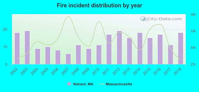
2002 - 2018 National Fire Incident Reporting System (NFIRS) incidents
Based on the data from the years 2002 - 2018 the average number of fires per year is 14. The highest number of fire incidents - 19 took place in 2003, and the least - 6 in 2007. The data has a constant trend.
When looking into fire subcategories, the most reports belonged to: Structure Fires (52.4%), and Outside Fires (35.5%).
Fire incident types reported to NFIRS in Nahant, MA


 Recent articles from our blog. Our writers, many of them Ph.D. graduates or candidates, create easy-to-read articles on a wide variety of topics.


 (3.5 miles


 Based on the data from the years 2002 - 2018 the average number of fires per year is 14. The highest number of fire incidents - 19 took place in 2003, and the least - 6 in 2007. The data has a constant trend.
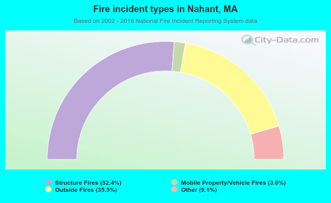 When looking into fire subcategories, the most reports belonged to: Structure Fires (52.4%), and Outside Fires (35.5%).