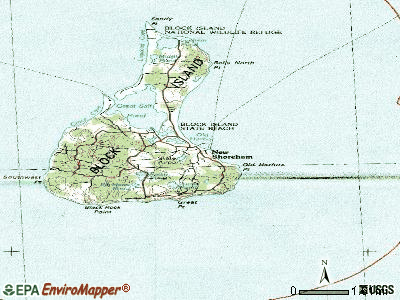
New Shoreham, Rhode Island
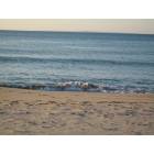
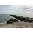
Submit your own pictures of this town and show them to the world
- OSM Map
- General Map
- Google Map
- MSN Map
Population change since 2000: +4.1%
 |
| Males: 538 | |
| Females: 513 |
| Median resident age: | 50.2 years |
| Rhode Island median age: | 42.3 years |
Zip codes: 02807.
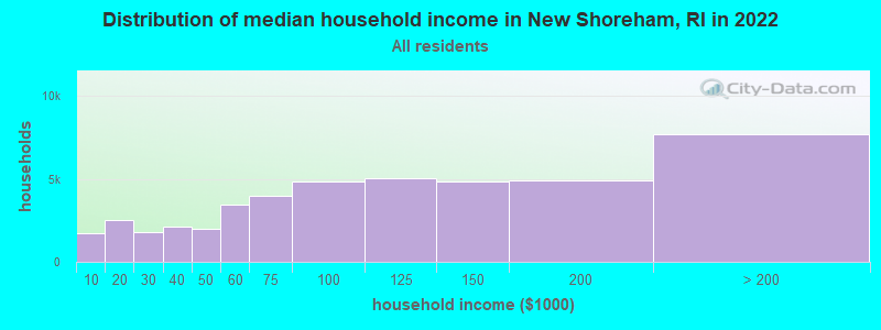
| New Shoreham: | $84,712 |
| RI: | $81,854 |
Estimated per capita income in 2022: $59,948 (it was $29,188 in 2000)
New Shoreham town income, earnings, and wages data
Estimated median house or condo value in 2022: over $1,000,000 (it was $488,000 in 2000)
| New Shoreham: | over $1,000,000 |
| RI: | $383,900 |
Mean prices in 2022: all housing units: $576,051; detached houses: $602,530; townhouses or other attached units: $477,043; in 2-unit structures: $442,161; in 3-to-4-unit structures: $386,238; in 5-or-more-unit structures: $205,983; mobile homes: $109,666; occupied boats, rvs, vans, etc.: over $1,000,000
Detailed information about poverty and poor residents in New Shoreham, RI


Compare current foreclosures near New Shoreham, RI:
| Photo | Address | Area | Beds / Baths | Price | Details |
|---|---|---|---|---|---|

|
#1
Tupelo Rd
Wakefield, RI 02879
|
702 sq. feet
|
1 baths 2 beds |
show details | |

|
#2
Ross Hill Rd
Charlestown, RI 02813
|
2,100 sq. feet
|
2 baths 3 beds |
show details | |

|
#3
Old Rd
Charlestown, RI 02813
|
1,664 sq. feet
|
2 baths 3 beds |
show details | |

|
#4
Palm Beach Ave
Narragansett, RI 02882
|
1,404 sq. feet
|
1 baths 3 beds |
show details | |

|
#5
Blue Ridge Dr
Charlestown, RI 02813
|
2,338 sq. feet
|
2 baths 3 beds |
show details | |

|
#6
Mohegan Trl
Block Island, RI 02807
|
- sq. feet
|
- baths - beds |
show details | |

|
#7
Johnson Ln
Charlestown, RI 02813
|
- sq. feet
|
- baths - beds |
show details | |

|
#8
E Woody Hill Rd
Westerly, RI 02891
|
- sq. feet
|
- baths - beds |
show details | |

|
#9
Shore Rd
Westerly, RI 02891
|
- sq. feet
|
- baths - beds |
show details | |

|
#10
S County Trl
Charlestown, RI 02813
|
- sq. feet
|
- baths - beds |
show details |
| Photo | Address | Area | Beds / Baths | Price | Details |
|---|---|---|---|---|---|

|
Check over 1 million property listings on Foreclosure.com!
|
browse all offers | |||
| Photo | Address | Area | Beds / Baths | Price | Details |
|---|

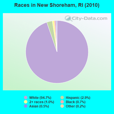
- 99594.7%White alone
- 312.9%Hispanic
- 101.0%Two or more races
- 70.7%Black alone
- 50.5%Asian alone
- 20.2%Other race alone
- 10.10%American Indian alone
Races in New Shoreham detailed stats: ancestries, foreign born residents, place of birth
Type |
2009 |
2010 |
2011 |
2012 |
2013 |
2014 |
2015 |
2016 |
2017 |
2018 |
2019 |
2020 |
2022 |
|---|---|---|---|---|---|---|---|---|---|---|---|---|---|
| Murders (per 100,000) | 0 (0.0) | 0 (0.0) | 0 (0.0) | 0 (0.0) | 0 (0.0) | 0 (0.0) | 0 (0.0) | 0 (0.0) | 0 (0.0) | 0 (0.0) | 0 (0.0) | 0 (0.0) | 0 (0.0) |
| Rapes (per 100,000) | 0 (0.0) | 1 (95.1) | 0 (0.0) | 0 (0.0) | 0 (0.0) | 0 (0.0) | 0 (0.0) | 0 (0.0) | 0 (0.0) | 0 (0.0) | 0 (0.0) | 0 (0.0) | 0 (0.0) |
| Robberies (per 100,000) | 0 (0.0) | 0 (0.0) | 0 (0.0) | 0 (0.0) | 0 (0.0) | 0 (0.0) | 0 (0.0) | 0 (0.0) | 0 (0.0) | 0 (0.0) | 0 (0.0) | 0 (0.0) | 1 (70.3) |
| Assaults (per 100,000) | 0 (0.0) | 0 (0.0) | 1 (95.2) | 2 (191.2) | 3 (288.5) | 0 (0.0) | 2 (191.6) | 0 (0.0) | 0 (0.0) | 4 (386.8) | 3 (290.7) | 0 (0.0) | 0 (0.0) |
| Burglaries (per 100,000) | 13 (1,255) | 7 (666.0) | 7 (666.7) | 2 (191.2) | 6 (576.9) | 3 (287.6) | 5 (478.9) | 4 (382.4) | 4 (383.1) | 1 (96.7) | 7 (678.3) | 2 (195.1) | 1 (70.3) |
| Thefts (per 100,000) | 36 (3,475) | 35 (3,330) | 36 (3,429) | 35 (3,346) | 14 (1,346) | 26 (2,493) | 43 (4,119) | 6 (573.6) | 13 (1,245) | 16 (1,547) | 15 (1,453) | 16 (1,561) | 9 (632.5) |
| Auto thefts (per 100,000) | 5 (482.6) | 1 (95.1) | 0 (0.0) | 1 (95.6) | 1 (96.2) | 0 (0.0) | 2 (191.6) | 0 (0.0) | 1 (95.8) | 2 (193.4) | 1 (96.9) | 0 (0.0) | 0 (0.0) |
| Arson (per 100,000) | 0 (0.0) | 0 (0.0) | 0 (0.0) | 0 (0.0) | 0 (0.0) | 0 (0.0) | 0 (0.0) | 0 (0.0) | 0 (0.0) | 0 (0.0) | 0 (0.0) | 0 (0.0) | 0 (0.0) |
| City-Data.com crime index | 265.4 | 263.6 | 202.9 | 193.1 | 159.6 | 119.8 | 251.9 | 49.7 | 84.3 | 161.5 | 171.5 | 76.1 | 51.3 |
The City-Data.com crime index weighs serious crimes and violent crimes more heavily. Higher means more crime, U.S. average is 246.1. It adjusts for the number of visitors and daily workers commuting into cities.
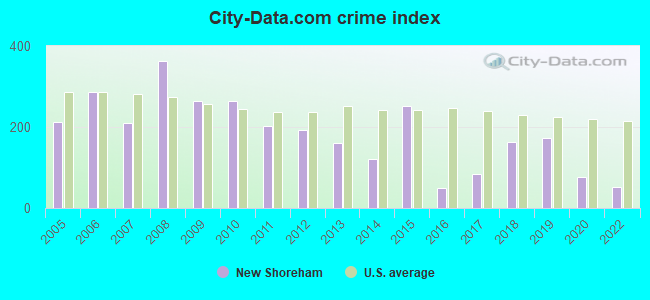
Crime rate in New Shoreham detailed stats: murders, rapes, robberies, assaults, burglaries, thefts, arson
Full-time law enforcement employees in 2021, including police officers: 12 (6 officers - 6 male; 0 female).
| Officers per 1,000 residents here: | 5.64 |
| Rhode Island average: | 2.27 |
 Recent articles from our blog. Our writers, many of them Ph.D. graduates or candidates, create easy-to-read articles on a wide variety of topics.


 | Crazy Rhode Island real estate market (525 replies) |
| Coronavirus in Rhode Island (3840 replies) |
| Providence drug trade (457 replies) |
| North Kingstown vs South Kingstown (159 replies) |
| Rhode Island residential real estate on fire. Up 12%+ over last year. (59 replies) |
| South Providence man arrested for raping woman at gunpoint in Lincoln Woods (79 replies) |
Latest news from New Shoreham, RI collected exclusively by city-data.com from local newspapers, TV, and radio stations
Ancestries: English (33.3%), Irish (33.2%), German (14.9%), Italian (8.6%), French (7.5%), Scottish (6.3%).
Current Local Time: EST time zone
Incorporated in 1664
Elevation: 40 feet
Land area: 9.73 square miles.
Population density: 108 people per square mile (very low).
34 residents are foreign born (1.7% Europe, 0.9% Latin America, 0.6% Asia).
| This town: | 3.4% |
| Rhode Island: | 11.4% |
| New Shoreham town: | 0.5% ($2,310) |
| Rhode Island: | 1.9% ($2,507) |
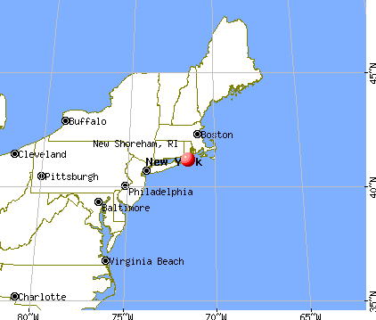
Nearest city with pop. 50,000+: Warwick, RI  (38.4 miles , pop. 85,808).
Nearest city with pop. 200,000+: Boston, MA (83.2 miles , pop. 589,141).
Nearest city with pop. 1,000,000+: Queens, NY (121.3 miles , pop. 2,229,379).
Nearest cities:
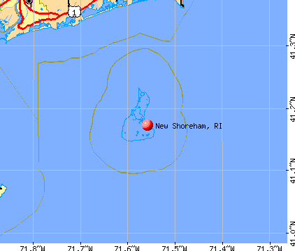
), ), ), ), Latitude: 41.18 N, Longitude: 71.58 W
Area code commonly used in this area: 401
New Shoreham tourist attractions:
- Block Island Ferry, Block Island, RI - New Shoreham, Rhode Island Three Departure Points and Sea Routes to Seaside Resort Island Running in Busy Season
- Malcolm Greenaway Gallery, Block Island, RI - New Shoreham, RI - Old Harbor Gallery Displays Photography Capturing Island Experience
- Mansion Beach, Block Island - New Shoreham, Rhode Island - White Sands Await Just Outside of Main Town on Seaside Island Resort
- Mohegan Bluffs, Block Island, RI - New Shoreham, Rhode Island - Isolated Bluff and Beach off the Coast of Rhode Island Offers Contemplative Setting
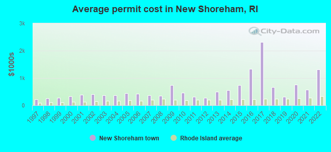
Single-family new house construction building permits:
- 2022: 7 buildings, average cost: $1,314,000
- 2021: 9 buildings, average cost: $574,600
- 2020: 8 buildings, average cost: $758,400
- 2019: 10 buildings, average cost: $305,600
- 2018: 8 buildings, average cost: $669,000
- 2017: 6 buildings, average cost: $2,312,500
- 2016: 2 buildings, average cost: $1,325,000
- 2015: 9 buildings, average cost: $745,600
- 2014: 14 buildings, average cost: $553,100
- 2013: 9 buildings, average cost: $490,900
- 2012: 5 buildings, average cost: $270,000
- 2011: 6 buildings, average cost: $320,800
- 2010: 8 buildings, average cost: $458,000
- 2009: 1 building, cost: $740,000
- 2008: 4 buildings, average cost: $342,800
- 2007: 44 buildings, average cost: $364,800
- 2006: 9 buildings, average cost: $430,000
- 2005: 8 buildings, average cost: $442,700
- 2004: 16 buildings, average cost: $373,500
- 2003: 18 buildings, average cost: $369,900
- 2002: 13 buildings, average cost: $404,400
- 2001: 14 buildings, average cost: $380,900
- 2000: 18 buildings, average cost: $331,000
- 1999: 19 buildings, average cost: $273,200
- 1998: 15 buildings, average cost: $264,200
- 1997: 25 buildings, average cost: $226,800

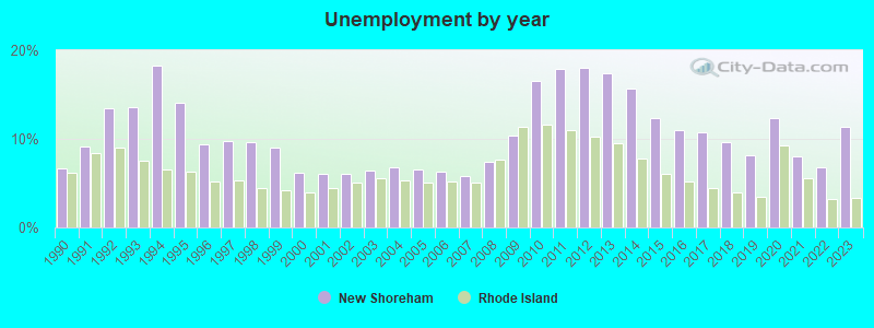
| Here: | 11.3% |
| Rhode Island: | 3.3% |
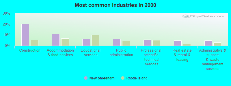
- Construction (20.3%)
- Accommodation & food services (10.8%)
- Educational services (6.4%)
- Public administration (6.2%)
- Professional, scientific, technical services (5.5%)
- Real estate & rental & leasing (4.8%)
- Administrative & support & waste management services (4.8%)
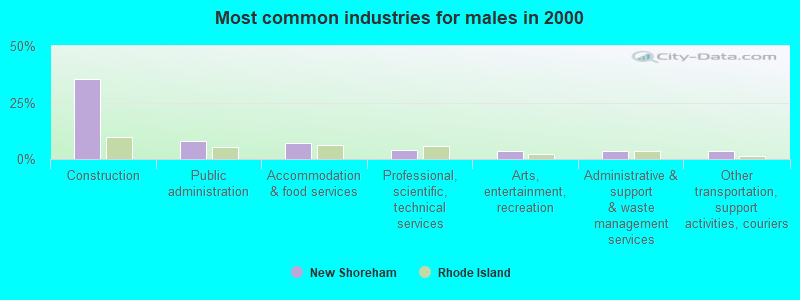
- Construction (35.4%)
- Public administration (8.0%)
- Accommodation & food services (7.3%)
- Professional, scientific, technical services (3.8%)
- Arts, entertainment, recreation (3.5%)
- Administrative & support & waste management services (3.5%)
- Other transportation, support activities, couriers (3.5%)
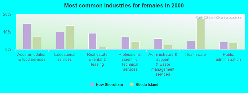
- Accommodation & food services (14.7%)
- Educational services (10.0%)
- Real estate & rental & leasing (9.3%)
- Professional, scientific, technical services (7.3%)
- Administrative & support & waste management services (6.2%)
- Health care (5.0%)
- Public administration (4.2%)
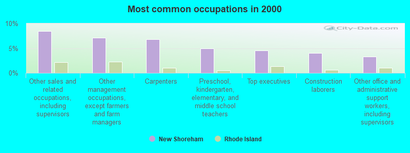
- Other sales and related occupations, including supervisors (8.4%)
- Other management occupations, except farmers and farm managers (7.1%)
- Carpenters (6.8%)
- Preschool, kindergarten, elementary, and middle school teachers (4.9%)
- Top executives (4.6%)
- Construction laborers (4.0%)
- Other office and administrative support workers, including supervisors (3.3%)

- Carpenters (12.2%)
- Construction laborers (7.6%)
- Top executives (6.9%)
- Other management occupations, except farmers and farm managers (6.6%)
- Other sales and related occupations, including supervisors (4.5%)
- Construction traders workers except carpenters, electricians, painters, plumbers, and construction laborers (3.8%)
- Electrical equipment mechanics and other installation, maintenance, and repair workers, including supervisors (3.5%)

- Other sales and related occupations, including supervisors (12.7%)
- Other management occupations, except farmers and farm managers (7.7%)
- Preschool, kindergarten, elementary, and middle school teachers (6.9%)
- Secretaries and administrative assistants (6.9%)
- Other office and administrative support workers, including supervisors (6.2%)
- Bookkeeping, accounting, and auditing clerks (5.0%)
- Information and record clerks, except customer service representatives (4.6%)
Average climate in New Shoreham, Rhode Island
Based on data reported by over 4,000 weather stations


(lower is better)
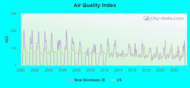
Air Quality Index (AQI) level in 2022 was 53.6. This is better than average.
| City: | 53.6 |
| U.S.: | 72.6 |
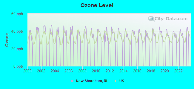
Ozone [ppb] level in 2022 was 36.6. This is about average. Closest monitor was 23.5 miles away from the city center.
| City: | 36.6 |
| U.S.: | 33.3 |
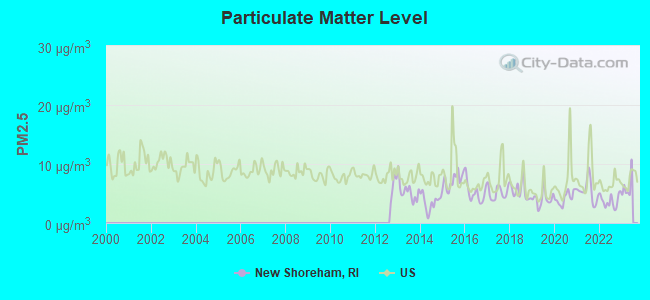
Particulate Matter (PM2.5) [µg/m3] level in 2022 was 3.74. This is significantly better than average. Closest monitor was 23.5 miles away from the city center.
| City: | 3.74 |
| U.S.: | 8.11 |
Tornado activity:
New Shoreham-area historical tornado activity is below Rhode Island state average. It is 76% smaller than the overall U.S. average.
On 8/21/1951, a category F3 (max. wind speeds 158-206 mph) tornado 55.3 miles away from the New Shoreham town center injured 8 people and caused between $50,000 and $500,000 in damages.
On 7/10/1989, a category F4 (max. wind speeds 207-260 mph) tornado 70.0 miles away from the town center injured 40 people and caused between $50,000,000 and $500,000,000 in damages.
Earthquake activity:
New Shoreham-area historical earthquake activity is significantly above Rhode Island state average. It is 75% smaller than the overall U.S. average.On 10/7/1983 at 10:18:46, a magnitude 5.3 (5.1 MB, 5.3 LG, 5.1 ML, Class: Moderate, Intensity: VI - VII) earthquake occurred 238.0 miles away from the city center
On 4/20/2002 at 10:50:47, a magnitude 5.3 (5.3 ML, Depth: 3.0 mi) earthquake occurred 254.5 miles away from the city center
On 8/22/1992 at 12:20:32, a magnitude 4.8 (4.8 MB, 3.8 MS, 4.7 LG, Depth: 6.2 mi, Class: Light, Intensity: IV - V) earthquake occurred 158.0 miles away from New Shoreham center
On 4/20/2002 at 10:50:47, a magnitude 5.2 (5.2 MB, 4.2 MS, 5.2 MW, 5.0 MW) earthquake occurred 253.3 miles away from New Shoreham center
On 1/19/1982 at 00:14:42, a magnitude 4.7 (4.5 MB, 4.7 MD, 4.5 LG) earthquake occurred 160.7 miles away from the city center
On 10/16/2012 at 23:12:25, a magnitude 4.7 (4.7 ML, Depth: 10.0 mi) earthquake occurred 174.0 miles away from the city center
Magnitude types: regional Lg-wave magnitude (LG), body-wave magnitude (MB), duration magnitude (MD), local magnitude (ML), surface-wave magnitude (MS), moment magnitude (MW)
Natural disasters:
The number of natural disasters in Washington County (17) is near the US average (15).Major Disasters (Presidential) Declared: 8
Emergencies Declared: 9
Causes of natural disasters: Hurricanes: 6, Snowstorms: 4, Blizzards: 3, Floods: 2, Storms: 2, Winter Storms: 2, Snow: 1, Snowfall: 1, Tropical Storm: 1, Wind: 1, Other: 1 (Note: some incidents may be assigned to more than one category).
Colleges/universities with over 2000 students nearest to New Shoreham:
- University of Rhode Island (about 22 miles; Kingston, RI; Full-time enrollment: 14,656)
- Salve Regina University (about 26 miles; Newport, RI; FT enrollment: 2,349)
- Connecticut College (about 31 miles; New London, CT; FT enrollment: 2,068)
- New England Institute of Technology (about 34 miles; East Greenwich, RI; FT enrollment: 3,183)
- Three Rivers Community College (about 36 miles; Norwich, CT; FT enrollment: 2,897)
- Roger Williams University (about 37 miles; Bristol, RI; FT enrollment: 4,375)
- Community College of Rhode Island (about 38 miles; Warwick, RI; FT enrollment: 10,500)
Points of interest:
Notable locations in New Shoreham: United States Weather Bureau Station (A), Block Island Southeast Lighthouse (B), Champlins Dock (C), Governor Gorton Farm (D), West Side Life Saving Station (E), Woonsocket House (F), Block Island Free Library (G), Block Island Historical Society Museum (H), New Shoreham Town Hall (I), Neptune Lodge Number 21 (J), New Shoreham Police Department (K), New Shoreham Fire and Rescue Block Island Station (L), Block Island Health Services Building (M). Display/hide their locations on the map
Churches in New Shoreham include: First Baptist CHurch (A), Primitive Methodist Church (B), Free Will Baptist Church (C). Display/hide their locations on the map
Cemeteries: Sheffield Cemetery (1), Island Cemetery (2), Dodge Cemetery (3). Display/hide their locations on the map
Lakes, reservoirs, and swamps: Ball Pond (A), Worden Pond (B), Spring House Ice Pond (C), Dees Tug Hole (D), Middle Pond (E), Sachem Pond (F), Wash Pond (G), Long Lot Pond (H). Display/hide their locations on the map
Parks in New Shoreham include: Middletown Square (1), Veterans Park (2), Old Harbor Historic District (3), Block Island National Wildlife Refuge (4). Display/hide their locations on the map
Beaches: Pebby Beach (A), Black Rock Beach (B), Mansion Beach (C), Block Island State Beach (D), Monhegan Bluffs Beach (E), West Beach (F). Display/hide their locations on the map
Birthplace of: William Paine Sheffield, Sr. - Politician.
Drinking water stations with addresses in New Shoreham and their reported violations in the past:
FREDRICK J. BENSON TOWN BEACH (Population served: 1,000, Groundwater):Past health violations:Past monitoring violations:
- MCL, Monthly (TCR) - In JUN-2012, Contaminant: Coliform. Follow-up actions: St Violation/Reminder Notice (JUN-18-2012), St Boil Water Order (JUN-18-2012), St Formal NOV issued (JUN-18-2012), St Public Notif requested (JUN-18-2012), St Public Notif received (JUN-19-2012), St Compliance achieved (OCT-11-2012)
- 4 routine major monitoring violations
- 3 minor monitoring violations
Drinking water stations with addresses in New Shoreham that have no violations reported:
- BLOCK ISLAND WATER COMPANY (Population served: 9,999, Primary Water Source Type: Groundwater)
| This town: | 2.0 people |
| Rhode Island: | 2.4 people |
| This town: | 55.4% |
| Whole state: | 62.8% |
| This town: | 7.0% |
| Whole state: | 7.6% |
Likely homosexual households (counted as self-reported same-sex unmarried-partner households)
- Lesbian couples: 0.8% of all households
- Gay men: 0.4% of all households
| This town: | 7.9% |
| Whole state: | 11.9% |
| This town: | 4.1% |
| Whole state: | 5.4% |
For population 15 years and over in New Shoreham:
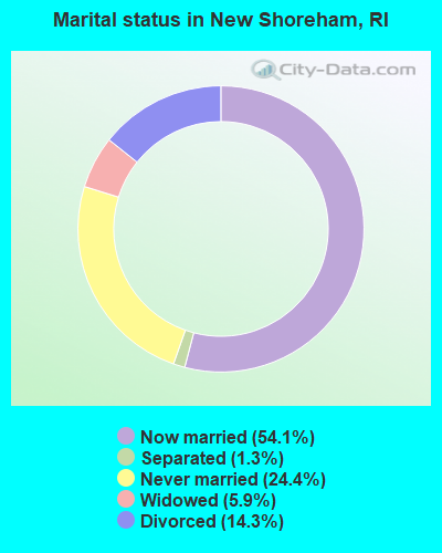
- Never married: 24.4%
- Now married: 54.1%
- Separated: 1.3%
- Widowed: 5.9%
- Divorced: 14.3%
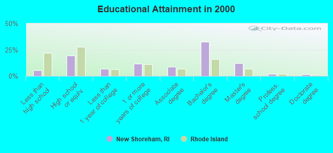
For population 25 years and over in New Shoreham:
- High school or higher: 94.7%
- Bachelor's degree or higher: 48.1%
- Graduate or professional degree: 15.5%
- Unemployed: 3.4%
- Mean travel time to work (commute): 8.3 minutes
| Here: | 8.9 |
| Rhode Island average: | 14.0 |
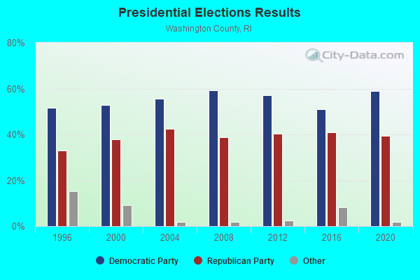
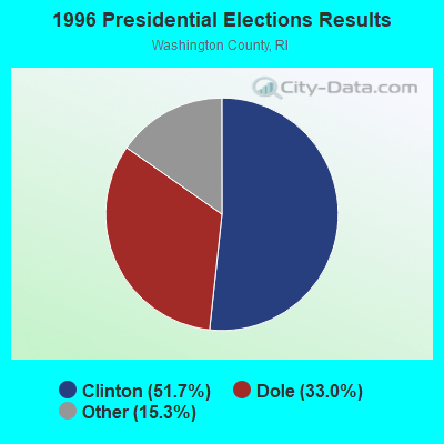
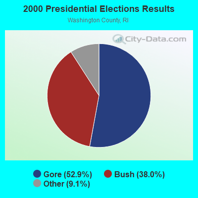
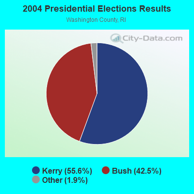
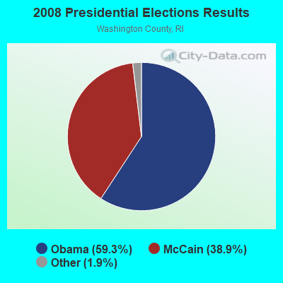
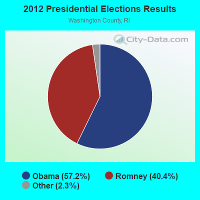
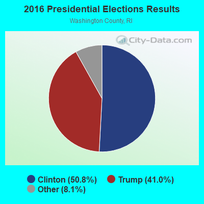

Graphs represent county-level data. Detailed 2008 Election Results
Religion statistics for New Shoreham, RI (based on Washington County data)
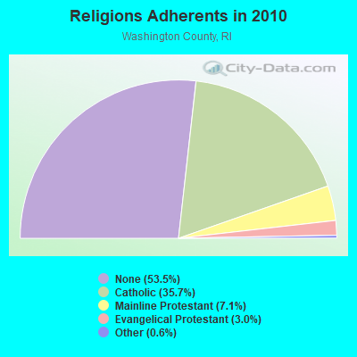
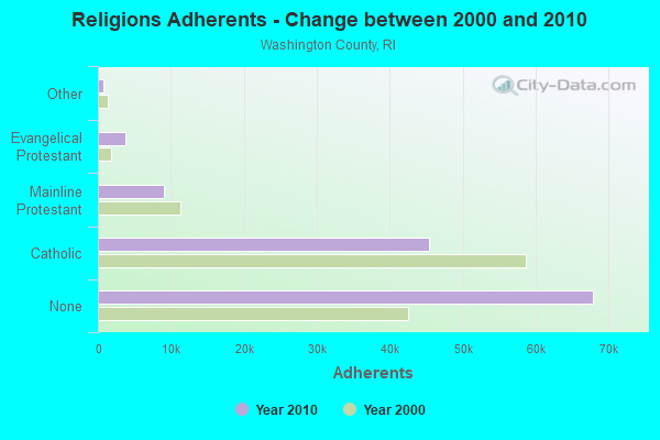
| Religion | Adherents | Congregations |
|---|---|---|
| Catholic | 45,382 | 17 |
| Mainline Protestant | 9,057 | 34 |
| Evangelical Protestant | 3,841 | 33 |
| Other | 796 | 8 |
| None | 67,903 | - |
Food Environment Statistics:
| Washington County: | 2.45 / 10,000 pop. |
| Rhode Island: | 1.92 / 10,000 pop. |
| Washington County: | 0.08 / 10,000 pop. |
| State: | 0.05 / 10,000 pop. |
| This county: | 1.34 / 10,000 pop. |
| State: | 1.42 / 10,000 pop. |
| This county: | 2.21 / 10,000 pop. |
| State: | 2.24 / 10,000 pop. |
| This county: | 12.41 / 10,000 pop. |
| Rhode Island: | 9.75 / 10,000 pop. |
| Washington County: | 6.8% |
| Rhode Island: | 7.9% |
| Washington County: | 19.8% |
| State: | 22.6% |
| Washington County: | 14.2% |
| Rhode Island: | 16.3% |
Strongest AM radio stations in New Shoreham:
- WALE (990 AM; 50 kW; GREENVILLE, RI; Owner: NORTH AMERICAN BROADCASTING CO., INC.)
- WCRN (830 AM; 50 kW; WORCESTER, MA; Owner: CARTER BROADCASTING CORPORATION)
- WEEI (850 AM; 50 kW; BOSTON, MA; Owner: ENTERCOM BOSTON LICENSE, LLC)
- WNNZ (640 AM; 50 kW; WESTFIELD, MA; Owner: CLEAR CHANNEL BROADCASTING LICENSES, INC.)
- WRKO (680 AM; 50 kW; BOSTON, MA; Owner: ENTERCOM BOSTON LICENSE, LLC)
- WTIC (1080 AM; 50 kW; HARTFORD, CT; Owner: INFINITY RADIO OPERATIONS INC.)
- WKOX (1200 AM; 50 kW; FRAMINGHAM, MA; Owner: CAPSTAR TX LIMITED PARTNERSHIP)
- WBZ (1030 AM; 50 kW; BOSTON, MA; Owner: INFINITY BROADCASTING OPERATIONS, INC.)
- WBIX (1060 AM; 40 kW; NATICK, MA; Owner: LANGER BROADCASTING CORPORATION)
- WFAN (660 AM; 50 kW; NEW YORK, NY; Owner: INFINITY BROADCASTING OPERATIONS, INC.)
- WVNE (760 AM; daytime; 25 kW; LEICESTER, MA; Owner: BLOUNT MASSCOM, INC.)
- WAMG (890 AM; 25 kW; DEDHAM, MA; Owner: MEGA COMMUNICATIONS OF DEDHAM LICENSEE, LLC)
- WWZN (1510 AM; 50 kW; BOSTON, MA; Owner: ROSE CITY RADIO CORPORATION)
Strongest FM radio stations in New Shoreham:
- WCRI (95.9 FM; BLOCK ISLAND, RI; Owner: CHARLES RIVER BROADCASTING WCRI LICENSE CORP.)
- WADK-FM (99.3 FM; BLOCK ISLAND, RI; Owner: ASTRO TELE-COMMUNICATIONS CORP.)
- WKKB (100.3 FM; MIDDLETOWN, RI; Owner: CITADEL BROADCASTING COMPANY)
- WRIU (90.3 FM; KINGSTON, RI; Owner: UNIVERSITY OF RHODE ISLAND)
- WSKO-FM (99.7 FM; WAKEFIELD-PEACEDALE, RI; Owner: CITADEL BROADCASTING COMPANY)
- WHJM (107.7 FM; PAWCATUCK, CT; Owner: FULLER BROADCASTING INTERNATIONAL, LLC)
- WXLM (102.3 FM; STONINGTON, CT; Owner: CITADEL BROADCASTING COMPANY)
- WWRX-FM (103.7 FM; WESTERLY, RI; Owner: FNX BROADCASTING OF RHODE ISLAND, LLC)
- WMOS (104.7 FM; MONTAUK, NY; Owner: CITADEL BROADCASTING COMPANY)
- WAKX (102.7 FM; NARRAGANSETT PIER, RI; Owner: AAA ENTERTAINMENT LICENSING LLC)
TV broadcast stations around New Shoreham:
- WPXQ (Channel 69; BLOCK ISLAND, RI; Owner: OCEAN STATE TELEVISION, L.L.C.)
- WHPX (Channel 26; NEW LONDON, CT; Owner: PAXSON HARTFORD LICENSE, INC.)
- National Bridge Inventory (NBI) Statistics
- 3Number of bridges
- 26ft / 8.1mTotal length
- $5,953,000Total costs
- 6,050Total average daily traffic
- 388Total average daily truck traffic
- 7,054Total future (year 2036) average daily traffic
FCC Registered Cell Phone Towers:
2 (See the full list of FCC Registered Cell Phone Towers in New Shoreham)FCC Registered Antenna Towers:
29 (See the full list of FCC Registered Antenna Towers)FCC Registered Microwave Towers:
9 (See the full list of FCC Registered Microwave Towers in this town)FCC Registered Maritime Coast & Aviation Ground Towers:
2 (See the full list of FCC Registered Maritime Coast & Aviation Ground Towers)FCC Registered Amateur Radio Licenses:
1- Call Sign: AL9S, Previous Call Sign: AD2HD, Licensee ID: L01440574, Grant Date: 06/06/2023, Expiration Date: 06/06/2033, Cancellation Date: 02/29/2024, Certifier: Timothy W England, Registrant: Timothy W England, General Delivery, New Shoreham, RI 02807

- 89.8%Fuel oil, kerosene, etc.
- 4.0%Wood
- 3.4%Bottled, tank, or LP gas
- 1.9%Other fuel
- 0.9%Coal or coke
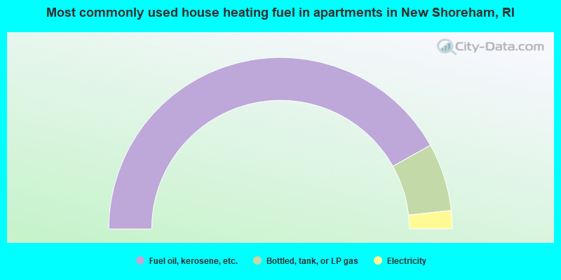
- 83.8%Fuel oil, kerosene, etc.
- 12.8%Bottled, tank, or LP gas
- 3.4%Electricity
New Shoreham compared to Rhode Island state average:
- Median house value significantly above state average.
- Unemployed percentage significantly below state average.
- Black race population percentage significantly below state average.
- Hispanic race population percentage significantly below state average.
- Median age above state average.
- Foreign-born population percentage significantly below state average.
- Length of stay since moving in significantly above state average.
- Number of rooms per house significantly below state average.
- House age significantly below state average.
- Number of college students below state average.
- Percentage of population with a bachelor's degree or higher above state average.
New Shoreham on our top lists:
- #28 on the list of "Top 100 cities with highest ratio of median house value to median household income"
- #2 on the list of "Top 101 counties with the highest percentage of residents that visited a dentist within the past year"
- #4 on the list of "Top 101 counties with the lowest number of births per 1000 residents 2007-2013"
- #7 on the list of "Top 101 counties with the largest decrease in the number of births per 1000 residents 2000-2006 to 2007-2013 (pop 50,000+)"
- #17 on the list of "Top 101 counties with the best general health status score of residents (1-5), 3 years of data"
- #44 on the list of "Top 101 counties with the highest percentage of residents that smoked 100+ cigarettes in their lives"