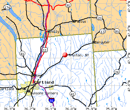
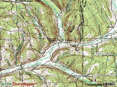
Truxton, New York
Submit your own pictures of this town and show them to the world
- OSM Map
- General Map
- Google Map
- MSN Map
Population change since 2000: -7.5%
 |
| Males: 576 | |
| Females: 557 |
| Median resident age: | 41.7 years |
| New York median age: | 40.7 years |
Zip codes: 13158.
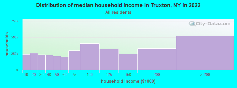
| Truxton: | $72,356 |
| NY: | $79,557 |
Estimated per capita income in 2022: $31,558 (it was $16,516 in 2000)
Truxton town income, earnings, and wages data
Estimated median house or condo value in 2022: $146,303 (it was $69,700 in 2000)
| Truxton: | $146,303 |
| NY: | $400,400 |
Mean prices in 2022: all housing units: $188,917; detached houses: $187,917; townhouses or other attached units: $146,406; in 2-unit structures: $635,934; in 3-to-4-unit structures: $122,178; in 5-or-more-unit structures: $371,569; mobile homes: $103,239
Detailed information about poverty and poor residents in Truxton, NY


- 1,08996.1%White alone
- 252.2%Hispanic
- 80.7%Two or more races
- 70.6%Black alone
- 20.2%American Indian alone
- 20.2%Asian alone
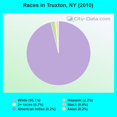
Races in Truxton detailed stats: ancestries, foreign born residents, place of birth
According to our research of New York and other state lists, there were 2 registered sex offenders living in Truxton, New York as of April 25, 2024.
The ratio of all residents to sex offenders in Truxton is 567 to 1.
 Recent articles from our blog. Our writers, many of them Ph.D. graduates or candidates, create easy-to-read articles on a wide variety of topics.


 | Is this what a typical child from New York really ate in the 1960s/70s? (41 replies) |
| Move out of Cortland, but where to? (23 replies) |
| When did the hipster invasion start? (47 replies) |
| A Move to Upstate New York (32 replies) |
| Can anyone compare DC and New York? (12 replies) |
| Which small town outside of Ithaca? (10 replies) |
Latest news from Truxton, NY collected exclusively by city-data.com from local newspapers, TV, and radio stations
Ancestries: Irish (20.5%), English (18.6%), German (15.8%), French (7.8%), United States (6.6%), Dutch (4.7%).
Current Local Time: EST time zone
Land area: 44.7 square miles.
Population density: 25 people per square mile (very low).
24 residents are foreign born
| This town: | 2.0% |
| New York: | 20.4% |
| Truxton town: | 2.4% ($1,685) |
| New York: | 1.9% ($2,847) |
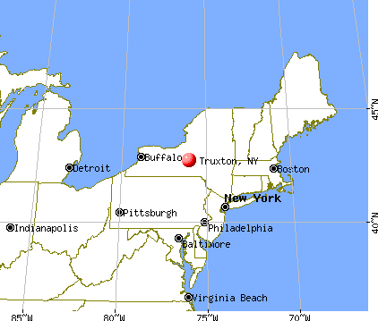
Nearest city with pop. 50,000+: Syracuse, NY  (24.1 miles , pop. 147,306).
Nearest city with pop. 200,000+: Rochester, NY (86.4 miles , pop. 219,773).
Nearest city with pop. 1,000,000+: Bronx, NY (170.0 miles , pop. 1,332,650).
Nearest cities:
), ), ), ), Latitude: 42.71 N, Longitude: 76.02 W
Area code: 607

Truxton tourist attractions:
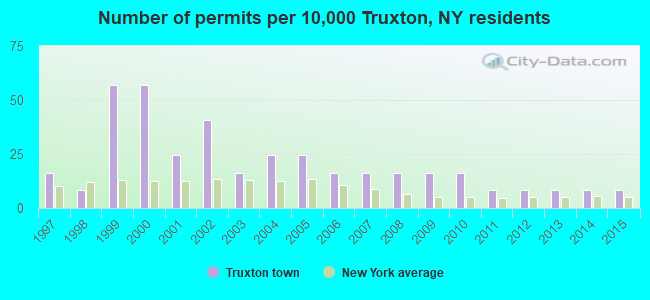
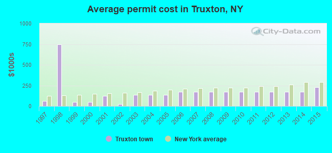
Single-family new house construction building permits:
- 2015: 1 building, cost: $226,800
- 2014: 1 building, cost: $171,000
- 2013: 1 building, cost: $171,000
- 2012: 1 building, cost: $171,000
- 2011: 1 building, cost: $171,000
- 2010: 2 buildings, average cost: $171,000
- 2009: 2 buildings, average cost: $171,000
- 2008: 2 buildings, average cost: $171,000
- 2007: 2 buildings, average cost: $171,000
- 2006: 2 buildings, average cost: $171,000
- 2005: 3 buildings, average cost: $132,800
- 2004: 3 buildings, average cost: $132,800
- 2003: 2 buildings, average cost: $132,800
- 2002: 5 buildings, average cost: $27,000
- 2001: 3 buildings, average cost: $121,400
- 2000: 7 buildings, average cost: $50,000
- 1999: 7 buildings, average cost: $50,000
- 1998: 1 building, cost: $750,000
- 1997: 2 buildings, average cost: $60,000
| Here: | 5.0% |
| New York: | 4.4% |
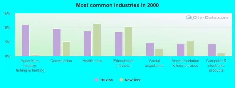
- Agriculture, forestry, fishing & hunting (11.1%)
- Construction (9.8%)
- Health care (8.9%)
- Educational services (8.4%)
- Social assistance (4.6%)
- Accommodation & food services (4.3%)
- Computer & electronic products (4.3%)
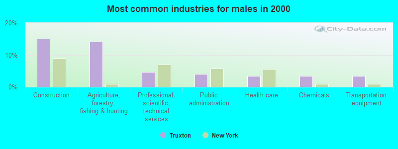
- Construction (15.1%)
- Agriculture, forestry, fishing & hunting (14.2%)
- Professional, scientific, technical services (4.7%)
- Public administration (4.1%)
- Health care (3.5%)
- Chemicals (3.5%)
- Transportation equipment (3.5%)
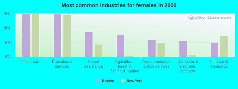
- Health care (15.0%)
- Educational services (15.0%)
- Social assistance (8.7%)
- Agriculture, forestry, fishing & hunting (7.7%)
- Accommodation & food services (5.9%)
- Computer & electronic products (5.6%)
- Finance & insurance (4.9%)
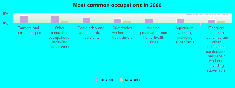
- Farmers and farm managers (6.6%)
- Other production occupations, including supervisors (6.3%)
- Secretaries and administrative assistants (4.3%)
- Driver/sales workers and truck drivers (3.8%)
- Nursing, psychiatric, and home health aides (3.6%)
- Agricultural workers, including supervisors (3.6%)
- Electrical equipment mechanics and other installation, maintenance, and repair workers, including supervisors (3.1%)
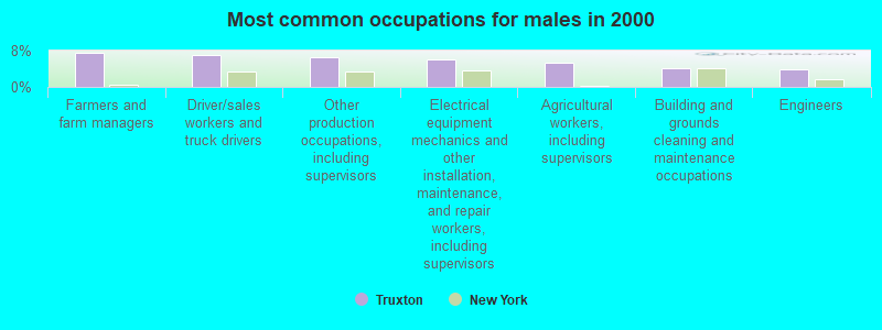
- Farmers and farm managers (7.5%)
- Driver/sales workers and truck drivers (6.9%)
- Other production occupations, including supervisors (6.6%)
- Electrical equipment mechanics and other installation, maintenance, and repair workers, including supervisors (6.0%)
- Agricultural workers, including supervisors (5.3%)
- Building and grounds cleaning and maintenance occupations (4.1%)
- Engineers (3.8%)

- Secretaries and administrative assistants (9.1%)
- Nursing, psychiatric, and home health aides (7.7%)
- Other production occupations, including supervisors (5.9%)
- Preschool, kindergarten, elementary, and middle school teachers (5.6%)
- Farmers and farm managers (5.6%)
- Cooks and food preparation workers (4.2%)
- Other teachers, instructors, education, training, and library occupations (4.2%)
Average climate in Truxton, New York
Based on data reported by over 4,000 weather stations


(lower is better)
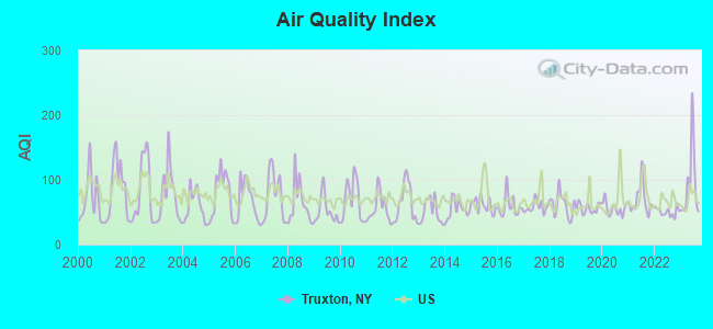
Air Quality Index (AQI) level in 2023 was 92.0. This is worse than average.
| City: | 92.0 |
| U.S.: | 72.6 |
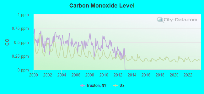
Carbon Monoxide (CO) [ppm] level in 2012 was 0.295. This is about average. Closest monitor was 23.8 miles away from the city center.
| City: | 0.295 |
| U.S.: | 0.251 |
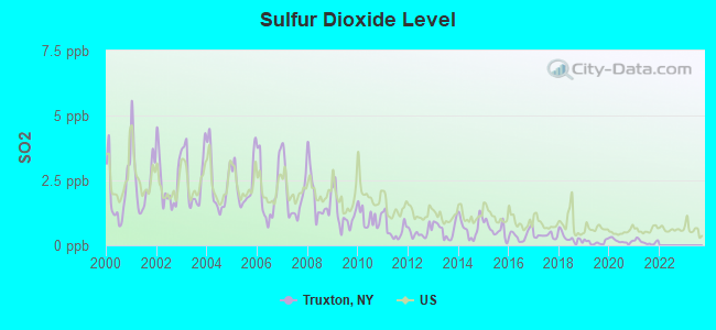
Sulfur Dioxide (SO2) [ppb] level in 2021 was 0.128. This is significantly better than average. Closest monitor was 12.2 miles away from the city center.
| City: | 0.128 |
| U.S.: | 1.515 |
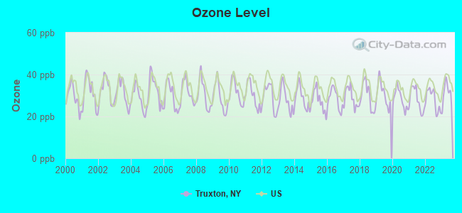
Ozone [ppb] level in 2023 was 30.9. This is about average. Closest monitor was 12.2 miles away from the city center.
| City: | 30.9 |
| U.S.: | 33.3 |
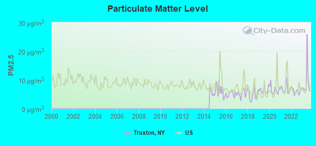
Particulate Matter (PM2.5) [µg/m3] level in 2023 was 9.42. This is about average. Closest monitor was 22.6 miles away from the city center.
| City: | 9.42 |
| U.S.: | 8.11 |
Tornado activity:
Truxton-area historical tornado activity is slightly below New York state average. It is 71% smaller than the overall U.S. average.
On 5/2/1983, a category F3 (max. wind speeds 158-206 mph) tornado 34.7 miles away from the Truxton town center killed one person and caused between $500,000 and $5,000,000 in damages.
On 5/2/1983, a category F3 tornado 38.6 miles away from the town center caused between $50,000 and $500,000 in damages.
Earthquake activity:
Truxton-area historical earthquake activity is significantly above New York state average. It is 67% smaller than the overall U.S. average.On 10/7/1983 at 10:18:46, a magnitude 5.3 (5.1 MB, 5.3 LG, 5.1 ML, Class: Moderate, Intensity: VI - VII) earthquake occurred 120.7 miles away from the city center
On 4/20/2002 at 10:50:47, a magnitude 5.3 (5.3 ML, Depth: 3.0 mi) earthquake occurred 170.6 miles away from the city center
On 4/20/2002 at 10:50:47, a magnitude 5.2 (5.2 MB, 4.2 MS, 5.2 MW, 5.0 MW) earthquake occurred 168.7 miles away from Truxton center
On 8/23/2011 at 17:51:04, a magnitude 5.8 (5.8 MW, Depth: 3.7 mi) earthquake occurred 346.9 miles away from Truxton center
On 9/25/1998 at 19:52:52, a magnitude 5.2 (4.8 MB, 4.3 MS, 5.2 LG, 4.5 MW, Depth: 3.1 mi) earthquake occurred 239.7 miles away from Truxton center
On 1/16/1994 at 01:49:16, a magnitude 4.6 (4.6 MB, 4.6 LG, Depth: 3.1 mi, Class: Light, Intensity: IV - V) earthquake occurred 164.6 miles away from the city center
Magnitude types: regional Lg-wave magnitude (LG), body-wave magnitude (MB), local magnitude (ML), surface-wave magnitude (MS), moment magnitude (MW)
Natural disasters:
The number of natural disasters in Cortland County (14) is near the US average (15).Major Disasters (Presidential) Declared: 7
Emergencies Declared: 5
Causes of natural disasters: Floods: 7, Storms: 7, Hurricanes: 2, Blizzard: 1, Heavy Rain: 1, Landslide: 1, Power Outage: 1, Snowstorm: 1, Wind: 1, Winter Storm: 1, Other: 2 (Note: some incidents may be assigned to more than one category).
Hospitals and medical centers near Truxton:
- CARING COMMUNITY HOSPICE OF CORTLAND (Hospital, about 10 miles away; CORTLAND, NY)
- CORTLAND PARK REHABILITATION AND NURSING CENTER (Nursing Home, about 10 miles away; CORTLAND, NY)
- CROWN CENTER FOR NURSING AND REHABILITATION (Nursing Home, about 11 miles away; CORTLAND, NY)
- CORTLAND REGIONAL MEDICAL CENTER, INC Acute Care Hospitals (about 11 miles away; CORTLAND, NY)
- CORTLAND COUNTY HEALTH DEPARTMENT (Home Health Center, about 11 miles away; CORTLAND, NY)
- ST. JOSEPH'S - CORTLAND (Dialysis Facility, about 12 miles away; CORTLAND, NY)
Colleges/universities with over 2000 students nearest to Truxton:
- SUNY College at Cortland (about 13 miles; Cortland, NY; Full-time enrollment: 6,838)
- Tompkins Cortland Community College (about 20 miles; Dryden, NY; FT enrollment: 3,884)
- Onondaga Community College (about 23 miles; Syracuse, NY; FT enrollment: 8,920)
- SUNY College of Environmental Science and Forestry (about 24 miles; Syracuse, NY; FT enrollment: 2,044)
- Le Moyne College (about 24 miles; Syracuse, NY; FT enrollment: 3,041)
- Syracuse University (about 24 miles; Syracuse, NY; FT enrollment: 20,717)
- Morrisville State College (about 25 miles; Morrisville, NY; FT enrollment: 2,823)
Public elementary/middle school in Truxton:
- HARTNETT ELEMENTARY SCHOOL (Students: 114, Location: ACADEMY ST, Grades: KG-6)
Points of interest:
Notable locations in Truxton: Forest Lake Campground (A), Frosty Morning Farm (B), Truxton Fire Department (C). Display/hide their locations on the map
Churches in Truxton include: Truxton Methodist Church (A), Saint Patricks Church (B). Display/hide their locations on the map
Cemeteries: Saint Patricks Cemetery (1), Truxton Village Protestant Cemetery (2), Cheningo Cemetery (3). Display/hide their locations on the map
Streams, rivers, and creeks: Kenney Brook (A), Labrador Creek (B), Morgan Hill Creek (C), Shackham Brook (D), Weeks Brook (E), Cheningo Creek (F). Display/hide their locations on the map
Birthplace of: John McGraw - Baseball player, John S. Harris - Politician, Warren Burtis - Baseball umpire.
Drinking water stations with addresses in Truxton and their reported violations in the past:
LABRADOR-MAIN (PUFFIN BIRD) (Population served: 1,500, Groundwater):Past monitoring violations:FOREST LAKE CAMPGROUND - TRUXTON (Address: 6019 DOG HOLLOW RD , Population served: 600, Groundwater):
- One routine major monitoring violation
Past monitoring violations:POOLE'S DRIVE IN (Address: 6007 Chenengo Rd. , Population served: 100, Groundwater):
- 2 routine major monitoring violations
Past monitoring violations:HIAWATHA INN (Population served: 50, Groundwater):
- 3 routine major monitoring violations
Past monitoring violations:LABRADOR - MINI (Population served: 26, Groundwater):
- 2 routine major monitoring violations
- 2 regular monitoring violations
Past monitoring violations:
- One routine major monitoring violation
| This town: | 2.6 people |
| New York: | 2.6 people |
| This town: | 68.9% |
| Whole state: | 63.5% |
| This town: | 13.7% |
| Whole state: | 6.8% |
Likely homosexual households (counted as self-reported same-sex unmarried-partner households)
- Lesbian couples: 0.7% of all households
- Gay men: 0.5% of all households
| This town: | 11.6% |
| Whole state: | 14.6% |
| This town: | 2.1% |
| Whole state: | 7.4% |
5 people in other noninstitutional group quarters in 2000
For population 15 years and over in Truxton:
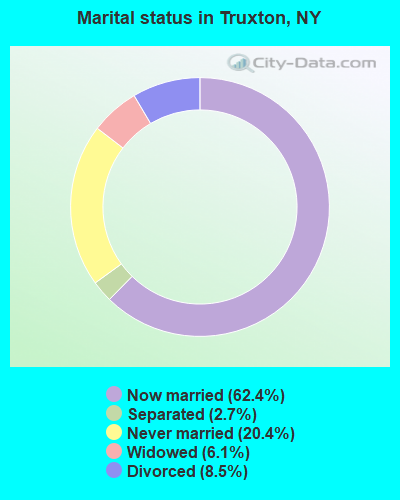
- Never married: 20.4%
- Now married: 62.4%
- Separated: 2.7%
- Widowed: 6.1%
- Divorced: 8.5%
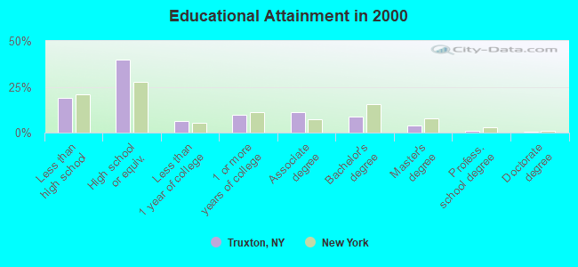
For population 25 years and over in Truxton:
- High school or higher: 81.2%
- Bachelor's degree or higher: 14.2%
- Graduate or professional degree: 5.3%
- Unemployed: 7.5%
- Mean travel time to work (commute): 26.9 minutes
| Here: | 10.6 |
| New York average: | 14.2 |
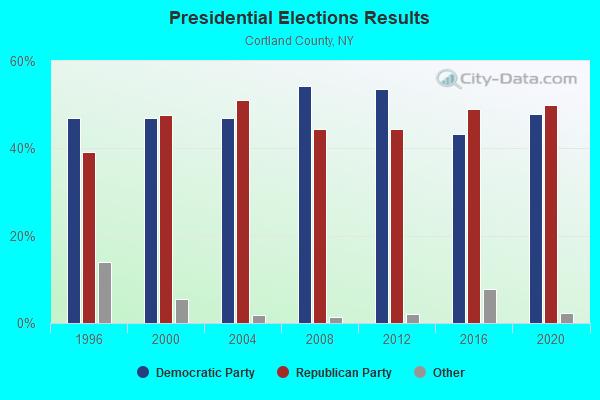
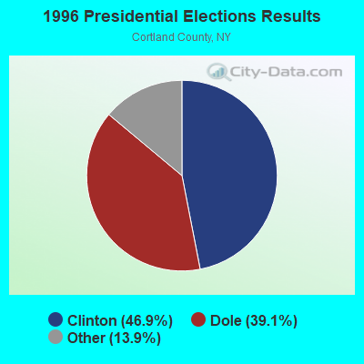
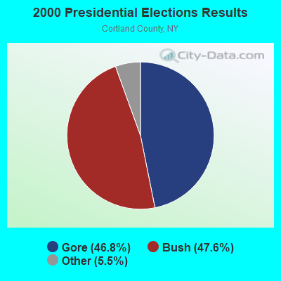
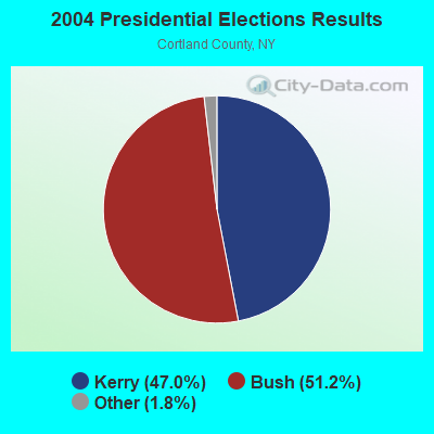
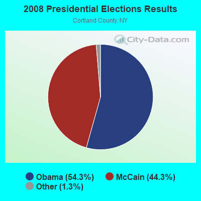

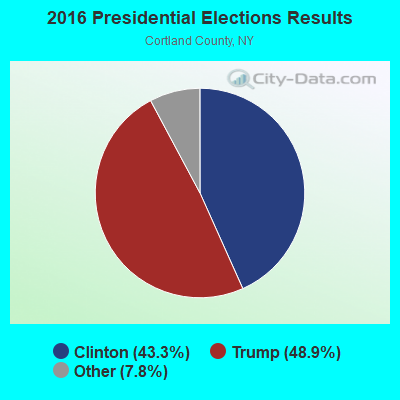

Graphs represent county-level data. Detailed 2008 Election Results
Religion statistics for Truxton, NY (based on Cortland County data)
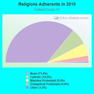
| Religion | Adherents | Congregations |
|---|---|---|
| Catholic | 6,378 | 5 |
| Mainline Protestant | 4,756 | 25 |
| Evangelical Protestant | 2,291 | 29 |
| Other | 483 | 6 |
| None | 35,428 | - |
Food Environment Statistics:
| Cortland County: | 2.48 / 10,000 pop. |
| New York: | 4.13 / 10,000 pop. |
| Cortland County: | 0.41 / 10,000 pop. |
| State: | 0.92 / 10,000 pop. |
| This county: | 3.92 / 10,000 pop. |
| New York: | 1.68 / 10,000 pop. |
| This county: | 9.29 / 10,000 pop. |
| New York: | 8.82 / 10,000 pop. |
| Cortland County: | 7.4% |
| New York: | 8.2% |
| Cortland County: | 24.5% |
| New York: | 23.8% |
| Here: | 11.7% |
| New York: | 15.6% |
Strongest AM radio stations in Truxton:
- WSYR (570 AM; 5 kW; SYRACUSE, NY; Owner: CLEAR CHANNEL BROADCASTING LICENSES, INC.)
- WHEN (620 AM; 5 kW; SYRACUSE, NY; Owner: CLEAR CHANNEL BROADCASTING LICENSES, INC.)
- WHCU (870 AM; 5 kW; ITHACA, NY; Owner: EAGLE BROADCASTING COMPANY, INC.)
- WNSS (1260 AM; 5 kW; SYRACUSE, NY; Owner: CITADEL BROADCASTING COMPANY)
- WKRT (920 AM; 1 kW; CORTLAND, NY; Owner: CITADEL BROADCASTING COMPANY)
- WSIV (1540 AM; 2 kW; E. SYRACUSE, NY; Owner: CRAM COMMUNICATIONS LLC)
- WGY (810 AM; 50 kW; SCHENECTADY, NY; Owner: CLEAR CHANNEL BROADCASTING LICENSES, INC.)
- WHAM (1180 AM; 50 kW; ROCHESTER, NY; Owner: CITICASTERS LICENSES, L.P.)
- WINR (680 AM; 5 kW; BINGHAMTON, NY; Owner: CLEVELAND RADIO LICENSES, LLC)
- WDCW (1390 AM; 5 kW; SYRACUSE, NY; Owner: KIMTRON, INC.)
- WNBF (1290 AM; 9 kW; BINGHAMTON, NY; Owner: CITADEL BROADCASTING COMPANY)
- WTKO (1470 AM; 5 kW; ITHACA, NY; Owner: EAGLE II BROADCASTING CORPORATION)
- WPIE (1160 AM; 5 kW; TRUMANSBURG, NY; Owner: PEMBROOK PINES ITHACA LTD. N.A.)
Strongest FM radio stations in Truxton:
- WXHC (101.5 FM; HOMER, NY; Owner: EVES BROADCASTING, INC.)
- WIII (99.9 FM; CORTLAND, NY; Owner: CITADEL BROADCASTING COMPANY)
- WCNY-FM (91.3 FM; SYRACUSE, NY; Owner: THE PUB. B/C COUNC. OF CEN. NY, INC.)
- WNTQ (93.1 FM; SYRACUSE, NY; Owner: CITADEL BROADCASTING COMPANY)
- W251AK (98.1 FM; NEDROW, NY; Owner: PATHWAY COMMUNITY RADIO, INC.)
- WYYY (94.5 FM; SYRACUSE, NY; Owner: CLEAR CHANNEL BROADCASTING LICENSES, INC.)
- WMHR (102.9 FM; SYRACUSE, NY; Owner: MARS HILL BROADCASTING CO., INC.)
- WWDG (105.1 FM; DERUYTER, NY; Owner: CLEAR CHANNEL BROADCASTING LICENSES, INC.)
- WYXL (97.3 FM; ITHACA, NY; Owner: EAGLE BROADCASTING COMPANY)
- WPHR (106.9 FM; AUBURN, NY; Owner: CLEAR CHANNEL BROADCASTING LICENSES, INC.)
- W278AH (103.5 FM; SYRACUSE, JAMESVILLE, NY; Owner: CALVARY CHAPEL OF THE FINGER LAKES, INC.)
- WWHT (107.9 FM; SYRACUSE, NY; Owner: CLEAR CHANNEL BROADCASTING LICENSES, INC.)
- WHWK (98.1 FM; BINGHAMTON, NY; Owner: CITADEL BROADCASTING COMPANY)
- WBKT (95.3 FM; NORWICH, NY; Owner: BANJO COMMUNICATIONS GROUP, INC)
- WMCR-FM (106.3 FM; ONEIDA, NY; Owner: WARREN BROADCASTING CO. INC.)
- WKXZ (93.9 FM; NORWICH, NY; Owner: BANJO COMMUNICATIONS GROUP, INC)
- WXXE (90.5 FM; FENNER, NY; Owner: SYRACUSE COMMUNITY RADIO, INC.)
- WAAL (99.1 FM; BINGHAMTON, NY; Owner: CITADEL BROADCASTING COMPANY)
- WQNY (103.7 FM; ITHACA, NY; Owner: EAGLE II BROADCASTING CORPORATION)
- WSKG-FM (89.3 FM; BINGHAMTON, NY; Owner: WSKG PUB.TELECOMMUNICATIONS COUNCIL)
TV broadcast stations around Truxton:
- WIXT-TV (Channel 9; SYRACUSE, NY; Owner: CENTRAL NY NEWS, INC.)
- WCNY-TV (Channel 24; SYRACUSE, NY; Owner: PUBLIC BROADCASTING COUNCIL OF CENTRAL NEW YORK)
- WSYT (Channel 68; SYRACUSE, NY; Owner: WSYT LICENSEE L.P.)
- WSTM-TV (Channel 3; SYRACUSE, NY; Owner: WSTM LICENSE SUBSIDIARY, INC.)
- WNYS-TV (Channel 43; SYRACUSE, NY; Owner: RKM MEDIA, INC.)
- WTVH (Channel 5; SYRACUSE, NY; Owner: WTVH LICENSE, INC.)
- WSPX-TV (Channel 56; SYRACUSE, NY; Owner: PAXSON SYRACUSE LICENSE, INC.)
- WFXV (Channel 33; UTICA, NY; Owner: QUORUM OF UTICA LICENSE, LLC)
- W11BP (Channel 11; SYRACUSE, ETC., NY; Owner: RENARD COMMUNICATIONS CORP.)
- W51BA (Channel 51; SYRACUSE, NY; Owner: RENARD COMMUNICATIONS CORP.)
- WTVU-LP (Channel 22; SYRACUSE, NY; Owner: RENARD COMMUNICATIONS CORP.)
- WNDR-LP (Channel 18; SYRACUSE, NY; Owner: METRO TV, INC.)
- WMBO-LP (Channel 60; SYRACUSE, ETC., NY; Owner: METRO TV, INC.)
- WOBX-LP (Channel 35; SYRACUSE, NY; Owner: METRO TV, INC.)
- WBLZ-LP (Channel 13; SYRACUSE, NY; Owner: RENARD COMMUNICATIONS CORP.)
- W40BJ (Channel 40; DEWITT, NY; Owner: RENARD COMMUNICATIONS CORP.)
- WSTQ-LP (Channel 14; SYRACUSE, NY; Owner: FEDERAL BROADCASTING COMPANY)
- W30AJ (Channel 30; SYRACUSE, NY; Owner: JOHN MESTER INCOME FAMILY TRUST)
- W38CY (Channel 38; SYRACUSE, NY; Owner: NATIONAL MINORITY T.V., INC.)
Truxton fatal accident list:
Mar 15, 2012 04:45 PM, Sr-91, Lat: 42.717797, Lon: -76.024375, Vehicles: 1, Persons: 1, Fatalities: 1, Drunk persons involved: 1
Jul 6, 2012 02:58 AM, Sr-13, Lat: 42.681578, Lon: -76.064167, Vehicles: 3, Persons: 1, Pedestrians: 1, Fatalities: 1, Drunk persons involved: 1
Sep 24, 2005 04:03 AM, Sr-13, Lat: 42.678440, Lon: -76.070510, Vehicles: 1, Persons: 2, Fatalities: 1
Dec 8, 2000 09:20 AM, Sr-91, Vehicles: 2, Persons: 3, Fatalities: 1
Nov 17, 1979 08:15 PM, Vehicles: 2, Persons: 7, Fatalities: 1
- National Bridge Inventory (NBI) Statistics
- 15Number of bridges
- 72ft / 21.5mTotal length
- $10,807,000Total costs
- 10,425Total average daily traffic
- 1,562Total average daily truck traffic
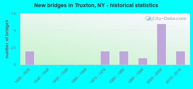
- New bridges - historical statistics
- 21930-1939
- 21970-1979
- 21980-1989
- 11990-1999
- 62000-2009
- 22010-2019
FCC Registered Cell Phone Towers:
1 (See the full list of FCC Registered Cell Phone Towers in Truxton)FCC Registered Antenna Towers:
20 (See the full list of FCC Registered Antenna Towers)FCC Registered Broadcast Land Mobile Towers:
3- 3733 Rt 13 (Lat: 42.707278 Lon: -76.029083), Call Sign: KDJ461,
Assigned Frequencies: 46.0800 MHz, Grant Date: 09/16/2005, Expiration Date: 11/27/2015, Cancellation Date: 07/02/2015, Registrant: Cortland County Department Of Emergency Response & Communications, 54 Greenbush Street, Cortland, NY 13045, Phone: (607) 753-5064, Fax: (607) 756-8457, Email:
- 3 Mi Se From Truxton Via Cr 154 (Crains Mills Rd)- S Hill Rd On Singleon Rd (Lat: 42.699167 Lon: -76.021667), Type: Tower, Structure height: 45.7 m, Call Sign: WPVQ766,
Assigned Frequencies: 855.537 MHz, 855.512 MHz, 855.262 MHz, 855.062 MHz, 855.787 MHz, 855.762 MHz, 854.787 MHz, 854.812 MHz, Grant Date: 08/01/2002, Expiration Date: 08/01/2012, Cancellation Date: 01/14/2011, Certifier: Thomas J Cowper, Registrant: Nys Dhses Office Of Interoperable And Emergency Communications, State Office Campus Building 22, 1220 Washington Ave, Albany, NY 12226, Phone: (518) 322-4912, Fax: (518) 322-4975, Email:
- TRUXTON, 3907 Singleton Rd (Lat: 42.699056 Lon: -76.019556), Type: Ltower, Structure height: 58.4 m, Overall height: 59.4 m, Call Sign: WQGC599,
Assigned Frequencies: 453.737 MHz, Grant Date: 09/15/2016, Expiration Date: 12/08/2026, Certifier: David L Tanner, Registrant: Cortland County, 54 Greenbush Street, Ste 201, Cortland, NY 13045, Phone: (607) 753-5064, Email:
FCC Registered Microwave Towers:
4- 3CDS726D, 3907 Singleton Road (Lat: 42.699139 Lon: -76.019583), Type: Ltower, Structure height: 59.4 m, Overall height: 60.7 m, Call Sign: WRAG244,
Assigned Frequencies: 11285.0 MHz, 11285.0 MHz, 11285.0 MHz, 11285.0 MHz, 11285.0 MHz, 11285.0 MHz, 11285.0 MHz, 11285.0 MHz, Grant Date: 11/07/2017, Expiration Date: 11/07/2027, Cancellation Date: 12/07/2021, Certifier: David Weblow, Registrant: T-Mobile Usa, Inc., 12920 Se 38th Street, Bellevue, WA 98006, Phone: (425) 383-8401, Fax: (425) 383-4040, Email:
- UP30848A, Kettlebail Rd. (272653) (Lat: 42.759028 Lon: -76.046139), Type: Gtower, Structure height: 91.4 m, Overall height: 93 m, Call Sign: WRYN205,
Assigned Frequencies: 11245.0 MHz, 11245.0 MHz, 11245.0 MHz, 11245.0 MHz, 11245.0 MHz, 11245.0 MHz, 11245.0 MHz, 11245.0 MHz, 11245.0 MHz, 11245.0 MHz... (+12 more), Grant Date: 08/29/2023, Expiration Date: 08/29/2033, Certifier: Jenny Knopf, Registrant: T-Mobile Usa, Inc., 12920 Se 38th Street, Bellevue, WA 98006, Phone: (425) 383-8401, Fax: (425) 383-4040, Email:
- 3CDS726D, Off Singleton Rd (Lat: 42.699139 Lon: -76.019583), Type: Ltower, Structure height: 59.4 m, Call Sign: WRYN207,
Assigned Frequencies: 10755.0 MHz, 10755.0 MHz, 10755.0 MHz, 10755.0 MHz, 10755.0 MHz, 10755.0 MHz, 10755.0 MHz, 10755.0 MHz, 10755.0 MHz, 10755.0 MHz... (+12 more), Grant Date: 08/29/2023, Expiration Date: 08/29/2033, Certifier: Jenny Knopf, Registrant: T-Mobile Usa, Inc., 12920 Se 38th Street, Bellevue, WA 98006, Phone: (425) 383-8401, Fax: (425) 383-4040, Email:
- TRUXTON, 3.0 Mi Nnw Of (Lat: 42.758389 Lon: -76.046028), Overall height: 93.9 m, Call Sign: WGW487,
Assigned Frequencies: 3770.00 MHz, 6197.24 MHz, 6197.24 MHz, 3770.00 MHz, 3850.00 MHz, 6256.54 MHz, 6256.54 MHz, 3850.00 MHz, 3930.00 MHz, 6315.84 MHz... (+16 more), Grant Date: 12/19/2000, Expiration Date: 02/01/2011, Cancellation Date: 10/01/2008, Certifier: Karen Zacharia, Registrant: Mci Communications Services, Inc., 2400 N. Glenville Drive, Dept/Loc 71216/107, Richardson, TX 75082, Phone: (972) 729-6406, Fax: (972) 729-2690, Email:
FCC Registered Amateur Radio Licenses:
5- Call Sign: KB2FAT, Grant Date: 02/02/1988, Expiration Date: 02/02/1998, Cancellation Date: 02/03/2000, Registrant: Ralph F Richter, 3617 Route 13, Truxton, NY 13158
- Call Sign: KB2LUW, Licensee ID: L00348126, Grant Date: 04/18/2001, Expiration Date: 07/16/2011, Cancellation Date: 07/17/2013, Registrant: George C Vogel, 6137 Cheningo Rd, Truxton, NY 13158
- Call Sign: N2TXQ, Grant Date: 02/23/1993, Expiration Date: 02/23/2003, Cancellation Date: 02/24/2005, Registrant: Phyllis C Keith, 7153 Route 91, Truxton, NY 13158
- Call Sign: KD7KHZ, Licensee ID: L00282070, Grant Date: 03/10/2021, Expiration Date: 03/10/2031, Certifier: Nathan E Warner, Registrant: Nathan E Warner, 429 Keeney Rd., Truxton, NY 13158-2100
- Call Sign: KC2OFP, Licensee ID: L01018834, Grant Date: 05/18/2005, Expiration Date: 05/18/2015, Cancellation Date: 05/19/2017, Certifier: Peter W Sahm, Registrant: Peter W Sahm, 3393 Rte 13, Truxton, NY 13158
FAA Registered Aircraft:
1- Aircraft: FEINT WALTER M AVENTURA (Category: Amphibian, Seats: 2, Weight: Up to 12,499 Pounds), Engine: BOMBARDIER ROTAX (ALL) (Reciprocating)
N-Number: 6411R, N6411R, N-6411R, Serial Number: AP2A0054, Year manufactured: 1999, Airworthiness Date: 04/18/2000, Certificate Issue Date: 09/27/1999
Registrant (Individual): Walter M Feint, 5420 Maybury Rd, Truxton, NY 13158
Deregistered: Cancel Date: 07/14/2017
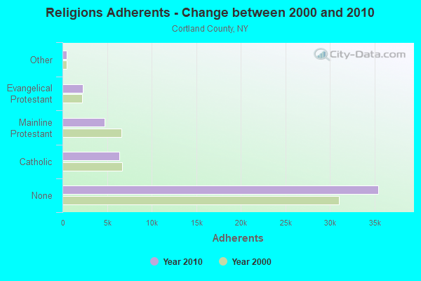
2003 - 2018 National Fire Incident Reporting System (NFIRS) incidents
- Fire incident types reported to NFIRS in Truxton, NY
- 7559.5%Structure Fires
- 3023.8%Outside Fires
- 1310.3%Mobile Property/Vehicle Fires
- 86.3%Other
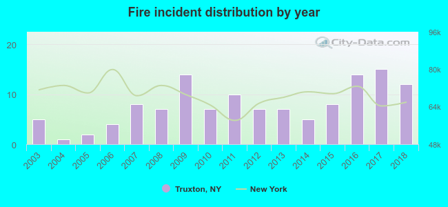 According to the data from the years 2003 - 2018 the average number of fires per year is 8. The highest number of reported fires - 15 took place in 2017, and the least - 1 in 2004. The data has an increasing trend.
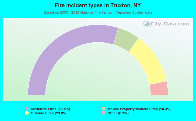 When looking into fire subcategories, the most incidents belonged to: Structure Fires (59.5%), and Outside Fires (23.8%).
| Most common first names in Truxton, NY among deceased individuals | ||
| Name | Count | Lived (average) |
|---|---|---|
| Charles | 7 | 69.6 years |
| Robert | 7 | 76.1 years |
| George | 6 | 70.0 years |
| John | 6 | 80.3 years |
| Margaret | 6 | 80.5 years |
| Donald | 5 | 77.4 years |
| Raymond | 5 | 70.8 years |
| Elizabeth | 4 | 80.2 years |
| Leon | 4 | 78.5 years |
| Edward | 4 | 66.0 years |
| Most common last names in Truxton, NY among deceased individuals | ||
| Last name | Count | Lived (average) |
|---|---|---|
| Smith | 9 | 77.9 years |
| Moore | 5 | 67.8 years |
| Potter | 5 | 81.2 years |
| Mccall | 5 | 62.4 years |
| Ryan | 5 | 74.0 years |
| Andrews | 4 | 72.5 years |
| Dwyer | 4 | 80.3 years |
| Maxson | 4 | 77.8 years |
| Brown | 4 | 68.0 years |
| Brooks | 3 | 80.3 years |
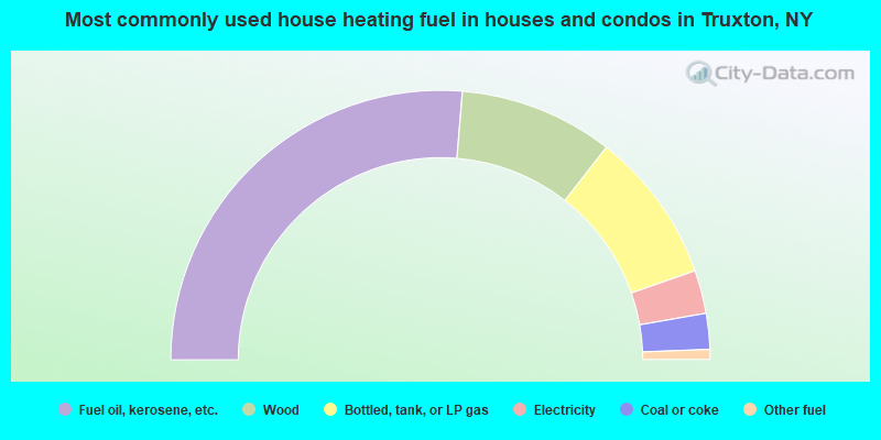
- 52.6%Fuel oil, kerosene, etc.
- 18.5%Wood
- 18.2%Bottled, tank, or LP gas
- 5.2%Electricity
- 4.3%Coal or coke
- 1.2%Other fuel
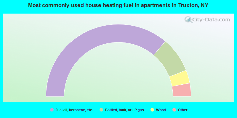
- 72.3%Fuel oil, kerosene, etc.
- 15.8%Bottled, tank, or LP gas
- 5.9%Wood
- 4.0%Electricity
- 2.0%Coal or coke
Truxton compared to New York state average:
- Median house value significantly below state average.
- Unemployed percentage below state average.
- Black race population percentage significantly below state average.
- Hispanic race population percentage significantly below state average.
- Foreign-born population percentage significantly below state average.
- Renting percentage significantly below state average.
- Length of stay since moving in significantly above state average.
- Number of rooms per house significantly below state average.
- House age significantly below state average.
- Number of college students below state average.
- Percentage of population with a bachelor's degree or higher below state average.

|
Total of 1 patent application in 2008-2024.