Union, New Jersey
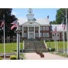
Union: Union Township Municipal Building

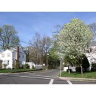
Union: Japanese Maple on Beechwood Ave In Union near Connecticut Farms

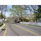
Union: brookside drive union, nj

Union: Close up Dogwood in Union Twp
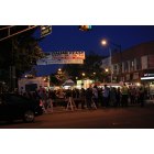
Union: italian festival '09 union, nj
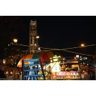
Union: italian festival '09
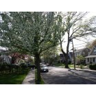
Union: Dogwood on my street in Union Twp
Union: Dogwood on my street in Union Twp 2
Union: Union Twp Firehouse
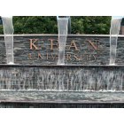
Union: Entrance to Kean University

Union
- see
15
more - add
your


Submit your own pictures of this place and show them to the world
- OSM Map
- General Map
- Google Map
- MSN Map
| Males: 25,279 | |
| Females: 28,771 |
| Median resident age: | 38.7 years |
| New Jersey median age: | 36.7 years |
Zip codes: 07083.
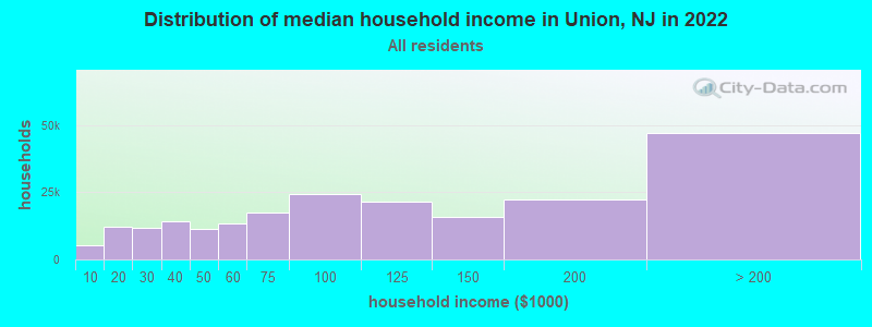
| Union: | $104,820 |
| NJ: | $96,346 |
Estimated per capita income in 2022: $47,906 (it was $24,768 in 2000)
Union CDP income, earnings, and wages data
Estimated median house or condo value in 2022: $467,862 (it was $173,400 in 2000)
| Union: | $467,862 |
| NJ: | $428,900 |
Mean prices in 2022: all housing units: $571,611; detached houses: $596,477; townhouses or other attached units: $609,757; in 2-unit structures: $452,159; in 3-to-4-unit structures: $316,757; in 5-or-more-unit structures: $383,498; mobile homes: $54,657
Detailed information about poverty and poor residents in Union, NJ


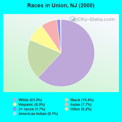
- 33,66161.9%White alone
- 10,56319.4%Black alone
- 4,8618.9%Hispanic
- 4,1917.7%Asian alone
- 9481.7%Two or more races
- 1070.2%Other race alone
- 650.1%American Indian alone
- 90.02%Native Hawaiian and Other
Pacific Islander alone
Races in Union detailed stats: ancestries, foreign born residents, place of birth
According to our research of New Jersey and other state lists, there were 5 registered sex offenders living in Union, New Jersey as of April 27, 2024.
The ratio of all residents to sex offenders in Union is 10,810 to 1.
The ratio of registered sex offenders to all residents in this city is much lower than the state average.
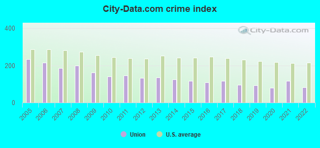
The City-Data.com crime index weighs serious crimes and violent crimes more heavily. Higher means more crime, U.S. average is 246.1. It adjusts for the number of visitors and daily workers commuting into cities.
- means the value is smaller than the state average.- means the value is about the same as the state average.
- means the value is bigger than the state average.
Crime rate in Union detailed stats: murders, rapes, robberies, assaults, burglaries, thefts, arson
Full-time law enforcement employees in 2021, including police officers: 185 (135 officers - 123 male; 12 female).
| Officers per 1,000 residents here: | 2.16 |
| New Jersey average: | 5.53 |
 Recent articles from our blog. Our writers, many of them Ph.D. graduates or candidates, create easy-to-read articles on a wide variety of topics.


Latest news from Union, NJ collected exclusively by city-data.com from local newspapers, TV, and radio stations
Ancestries: Italian (17.2%), German (10.2%), Irish (9.9%), Polish (9.0%), Portuguese (6.8%), West Indian (3.6%).
Current Local Time: EST time zone
Land area: 9.12 square miles.
Population density: 5,929 people per square mile (average).
13,360 residents are foreign born (9.7% Europe, 7.1% Latin America, 5.7% Asia).
| This place: | 24.6% |
| New Jersey: | 17.5% |
| Union CDP: | 2.5% ($4,334) |
| New Jersey: | 2.4% ($4,047) |
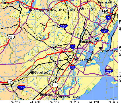
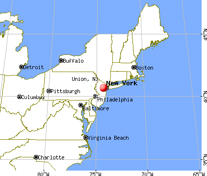
Nearest city with pop. 200,000+: Newark, NJ  (5.2 miles , pop. 273,546).
Nearest city with pop. 1,000,000+: Manhattan, NY (16.4 miles , pop. 1,537,195).
Nearest cities:
), Latitude: 40.70 N, Longitude: 74.27 W
Daytime population change due to commuting: +4,908 (+9.0%)
Workers who live and work in this place: 4,865 (18.9%)
Area codes: 201, 551
Union, New Jersey accommodation & food services, waste management - Economy and Business Data
| Here: | 4.7% |
| New Jersey: | 4.5% |
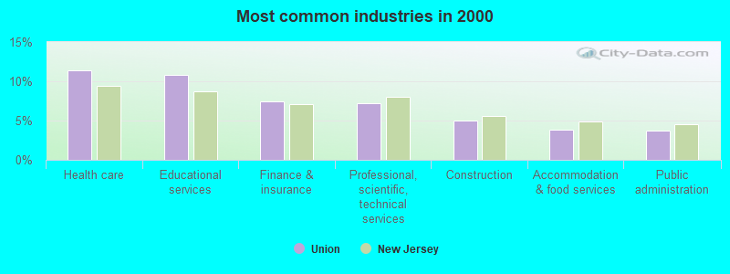
- Health care (11.4%)
- Educational services (10.8%)
- Finance & insurance (7.4%)
- Professional, scientific, technical services (7.2%)
- Construction (5.0%)
- Accommodation & food services (3.8%)
- Public administration (3.7%)
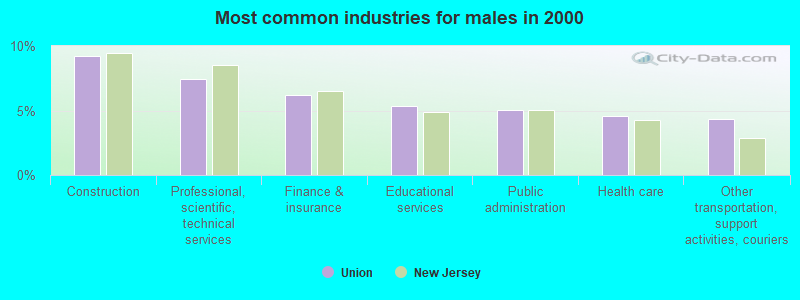
- Construction (9.2%)
- Professional, scientific, technical services (7.4%)
- Finance & insurance (6.2%)
- Educational services (5.4%)
- Public administration (5.0%)
- Health care (4.5%)
- Other transportation, support activities, couriers (4.3%)
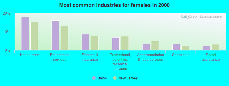
- Health care (18.2%)
- Educational services (16.1%)
- Finance & insurance (8.6%)
- Professional, scientific, technical services (7.0%)
- Accommodation & food services (3.5%)
- Chemicals (3.4%)
- Social assistance (2.4%)
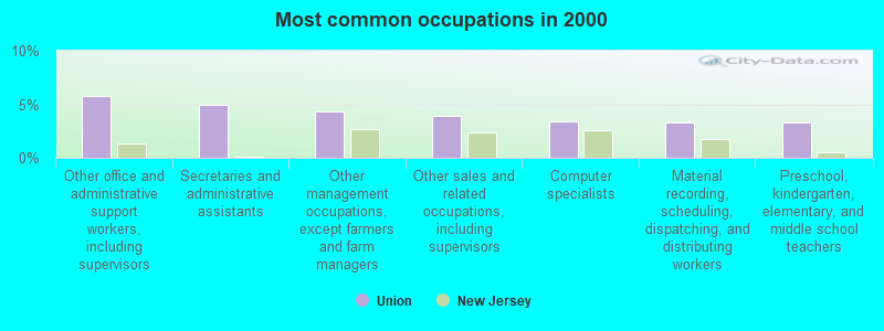
- Other office and administrative support workers, including supervisors (5.7%)
- Secretaries and administrative assistants (4.9%)
- Other management occupations, except farmers and farm managers (4.4%)
- Other sales and related occupations, including supervisors (3.9%)
- Computer specialists (3.4%)
- Material recording, scheduling, dispatching, and distributing workers (3.3%)
- Preschool, kindergarten, elementary, and middle school teachers (3.3%)
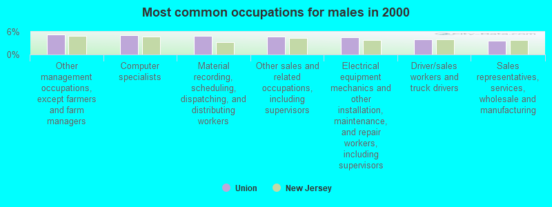
- Other management occupations, except farmers and farm managers (5.2%)
- Computer specialists (5.1%)
- Material recording, scheduling, dispatching, and distributing workers (5.0%)
- Other sales and related occupations, including supervisors (4.7%)
- Electrical equipment mechanics and other installation, maintenance, and repair workers, including supervisors (4.5%)
- Driver/sales workers and truck drivers (3.9%)
- Sales representatives, services, wholesale and manufacturing (3.7%)
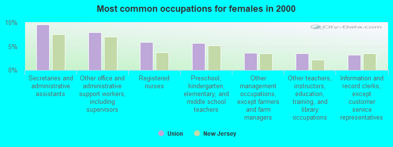
- Secretaries and administrative assistants (9.6%)
- Other office and administrative support workers, including supervisors (7.9%)
- Registered nurses (5.9%)
- Preschool, kindergarten, elementary, and middle school teachers (5.6%)
- Other management occupations, except farmers and farm managers (3.6%)
- Other teachers, instructors, education, training, and library occupations (3.5%)
- Information and record clerks, except customer service representatives (3.2%)
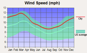
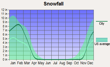
Average climate in Union, New Jersey
Based on data reported by over 4,000 weather stations


|
|


(lower is better)
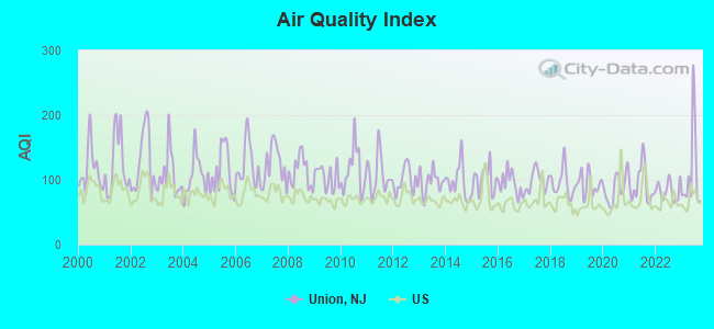
Air Quality Index (AQI) level in 2023 was 111. This is significantly worse than average.
| City: | 111 |
| U.S.: | 73 |
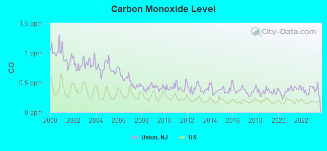
Carbon Monoxide (CO) [ppm] level in 2023 was 0.372. This is significantly worse than average. Closest monitor was 3.8 miles away from the city center.
| City: | 0.372 |
| U.S.: | 0.251 |
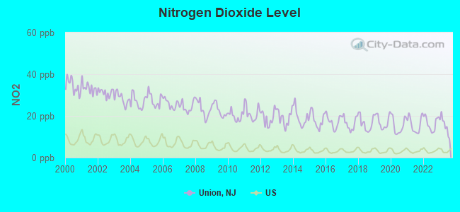
Nitrogen Dioxide (NO2) [ppb] level in 2023 was 15.3. This is significantly worse than average. Closest monitor was 4.0 miles away from the city center.
| City: | 15.3 |
| U.S.: | 5.1 |
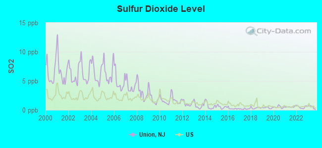
Sulfur Dioxide (SO2) [ppb] level in 2023 was 0.554. This is significantly better than average. Closest monitor was 2.6 miles away from the city center.
| City: | 0.554 |
| U.S.: | 1.515 |
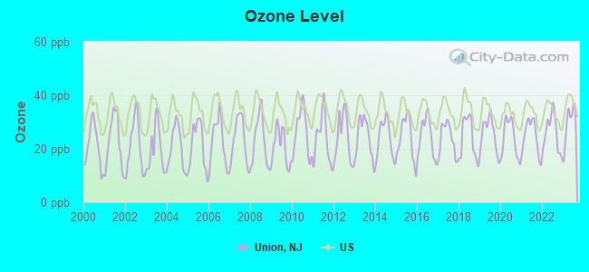
Ozone [ppb] level in 2023 was 29.3. This is about average. Closest monitor was 4.4 miles away from the city center.
| City: | 29.3 |
| U.S.: | 33.3 |
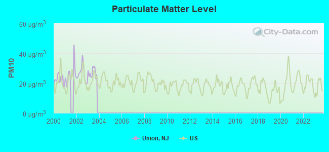
Particulate Matter (PM10) [µg/m3] level in 2003 was 26.9. This is worse than average. Closest monitor was 4.4 miles away from the city center.
| City: | 26.9 |
| U.S.: | 19.2 |
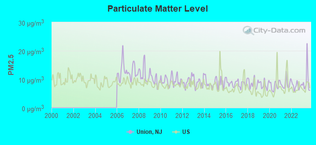
Particulate Matter (PM2.5) [µg/m3] level in 2023 was 9.45. This is about average. Closest monitor was 3.4 miles away from the city center.
| City: | 9.45 |
| U.S.: | 8.11 |
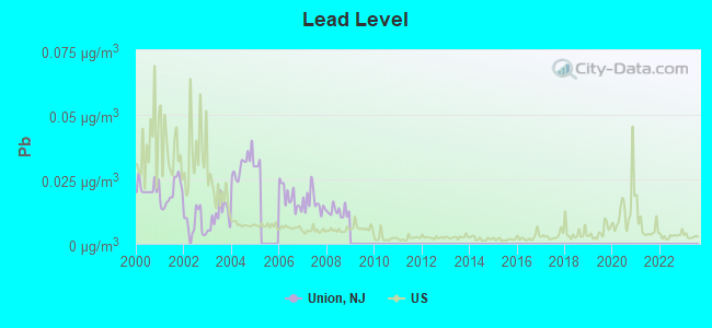
Lead (Pb) [µg/m3] level in 2008 was 0.0125. This is worse than average. Closest monitor was 3.9 miles away from the city center.
| City: | 0.0125 |
| U.S.: | 0.0093 |
Tornado activity:
Union-area historical tornado activity is near New Jersey state average. It is 34% smaller than the overall U.S. average.
On 5/28/1973, a category F3 (max. wind speeds 158-206 mph) tornado 14.0 miles away from the Union place center caused between $50,000 and $500,000 in damages.
On 5/28/1973, a category F3 tornado 25.8 miles away from the place center injured 12 people and caused between $50,000 and $500,000 in damages.
Earthquake activity:
Union-area historical earthquake activity is significantly above New Jersey state average. It is 68% smaller than the overall U.S. average.On 8/23/2011 at 17:51:04, a magnitude 5.8 (5.8 MW, Depth: 3.7 mi, Class: Moderate, Intensity: VI - VII) earthquake occurred 275.0 miles away from the city center
On 10/7/1983 at 10:18:46, a magnitude 5.3 (5.1 MB, 5.3 LG, 5.1 ML) earthquake occurred 225.2 miles away from the city center
On 1/16/1994 at 01:49:16, a magnitude 4.6 (4.6 MB, 4.6 LG, Depth: 3.1 mi, Class: Light, Intensity: IV - V) earthquake occurred 96.3 miles away from Union center
On 4/20/2002 at 10:50:47, a magnitude 5.3 (5.3 ML, Depth: 3.0 mi) earthquake occurred 265.5 miles away from the city center
On 4/20/2002 at 10:50:47, a magnitude 5.2 (5.2 MB, 4.2 MS, 5.2 MW, 5.0 MW) earthquake occurred 263.7 miles away from the city center
On 1/16/1994 at 00:42:43, a magnitude 4.2 (4.2 MB, 4.0 LG, Depth: 3.1 mi) earthquake occurred 94.8 miles away from the city center
Magnitude types: regional Lg-wave magnitude (LG), body-wave magnitude (MB), local magnitude (ML), surface-wave magnitude (MS), moment magnitude (MW)
Natural disasters:
The number of natural disasters in Union County (27) is a lot greater than the US average (15).Major Disasters (Presidential) Declared: 17
Emergencies Declared: 10
Causes of natural disasters: Floods: 7, Hurricanes: 7, Storms: 6, Heavy Rains: 4, Snowstorms: 3, Blizzards: 2, Water Shortages: 2, Winter Storms: 2, Power Outage: 1, Tornado: 1, Wind: 1, Other: 3 (Note: some incidents may be assigned to more than one category).

Main business address for: CENTER BANCORP INC (STATE COMMERCIAL BANKS), TRANSTECHNOLOGY CORP (AIRCRAFT PART & AUXILIARY EQUIPMENT, NEC), BED BATH & BEYOND INC (RETAIL-HOME FURNITURE, FURNISHINGS & EQUIPMENT STORES).
Hospitals and medical centers in Union:
- HEALTHSOUTH SPECIALTY HOSPITAL OF UNION (provides emergency services, 1000 GALLOPING HILL ROAD)
- UNION HOSPITAL (1000 GALLOPING HILL RD)
- CORNELL HALL CARE AND REHABILITATION CENTER (234 CHESTNUT STREET)
- CORNELL HALL CONVALESCENT CENTER (234 CHESTNUT STREET)
- FMC HILLSIDE DIALYSIS CTR (879 RAHWAY AVENUE)
Amtrak stations near Union:
- 4 miles: NEWARK INTERNATIONAL AIRPORT (NEWARK, ) . Services: ticket office, enclosed waiting area, public restrooms, public payphones.
- 7 miles: NEWARK (RAYMOND PLAZA WEST) . Services: ticket office, fully wheelchair accessible, enclosed waiting area, public restrooms, public payphones, snack bar, ATM, paid short-term parking, paid long-term parking, call for car rental service, taxi stand, intercity bus service, public transit connection.
- 10 miles: METROPARK (ISELIN, 100 MIDDLESEX-ESSEX TPK.) . Services: ticket office, fully wheelchair accessible, enclosed waiting area, public restrooms, public payphones, paid short-term parking, call for car rental service, taxi stand, public transit connection.
Colleges/Universities in Union:
- Kean University (Full-time enrollment: 12,648; Location: 1000 Morris Avenue; Public; Website: www.kean.edu; Offers Doctor's degree)
- Lincoln Technical Institute-Union (Full-time enrollment: 1,188; Location: 2299 Vauxhall Rd; Private, for-profit; Website: WWW.LINCOLNedu.COM)
- Healthcare Training Institute (Full-time enrollment: 171; Location: 1969 Morris Ave; Private, for-profit; Website: www.htinj.edu)
- Empire Beauty School-Union (Full-time enrollment: 130; Location: 1126 Morris Ave; Private, for-profit; Website: www.empire.edu)
Other colleges/universities with over 2000 students near Union:
- Union County College (about 4 miles; Cranford, NJ; Full-time enrollment: 9,148)
- Seton Hall University (about 4 miles; South Orange, NJ; FT enrollment: 7,742)
- University of Medicine and Dentistry of New Jersey (about 6 miles; Newark, NJ; FT enrollment: 3,210)
- Essex County College (about 6 miles; Newark, NJ; FT enrollment: 9,595)
- New Jersey Institute of Technology (about 6 miles; Newark, NJ; FT enrollment: 8,212)
- Rutgers University-Newark (about 6 miles; Newark, NJ; FT enrollment: 9,869)
- College of Staten Island CUNY (about 10 miles; Staten Island, NY; FT enrollment: 11,684)
Public high school in Union:
- UNION SENIOR HIGH (Students: 2,553, Location: 2350 NORTH THIRD STREET, Grades: 9-12)
Public elementary/middle schools in Union:
- BURNET MIDDLE SCHOOL (Students: 1,045, Location: 1000 CALDWELL AVENUE, Grades: 6-8)
- KAWAMEEH MIDDLE SCHOOL (Students: 733, Location: 490 DAVID TERRACE, Grades: 6-8)
- WASHINGTON (Students: 588, Location: 301 WASHINGTON AVENUE, Grades: PK-4)
- HANNAH CALDWELL ELEM SCH (Students: 560, Location: 1120 COMMERCE AVENUE, Grades: PK-4)
- CONNECTICUT FARMS (Students: 483, Location: 875 STUYVESANT AVENUE, Grades: PK-4)
- BATTLE HILL (Students: 451, Location: 2600 KILLIAN PLACE, Grades: PK-4)
- LIVINGSTON (Students: 421, Location: 960 MIDLAND BLVD, Grades: PK-4)
- JEFFERSON ELEMENTARY (Location: 155 HILTON AVENUE, Grades: 5)
- FRANKLIN ELEMENTARY (Location: 1500 LINDY TERRACE, Grades: PK-4)
Private elementary/middle schools in Union:
User-submitted facts and corrections:
- I would like to get Faith United Church of Christ, 1340 Burnet Avenue, Union listed under churches in Union.
Points of interest:
Notable locations in Union: Galloping Hill Park and Golf Course (A), Suburban Golf Course (B), Union Rail Station (C), Liberty Hall Museum (D), Townley House (E), Townsend Hall (F), Bruce Hall (G), Science Building (H), New Academic Building (I), Hutchinson Hall (J), Willis Hall (K), New Academic Building 2 (L), Wilkens Theatre (M), Nancy Thompson Library (N), Vaughn Eames (O), Downs Hall (P), Whiteman Hall (Q), Dougall Hall (R), Burch Hall (S), Rogers Hall (T). Display/hide their locations on the map
Main business address in Union include: CENTER BANCORP INC (A), TRANSTECHNOLOGY CORP (B), BED BATH & BEYOND INC (C). Display/hide their locations on the map
Churches in Union include: Townley Church (A), Christ Church (B), Saint Michael's Catholic Church (C), Congregation B'nai Ahavath (D), Saint Matthew's Lutheran Church (E). Display/hide their locations on the map
Cemetery: Hollywood Memorial Park (1). Display/hide its location on the map
River: West Branch Elizabeth River (A). Display/hide its location on the map
Parks in Union include: Elizabeth River Parkway (1), Elizabeth River Park (2), Friberger Park (3), Alumni Field (4), Kawameeh Park (5), Biertuempful Park (6). Display/hide their locations on the map
Tourist attractions: Computer Science Technologies Corporation (Nature Centers; 244 Parkside Drive), Evergreen Vending Inc (Amusement & Theme Parks; 1396 Stuyvesant Avenue), Europe For You (Tours & Charters; 1657 Burnet Avenue).
Hotels: Europe For You (1657 Burnet Avenue), Garden State Motor Lodge Motel (USHighway 22 North).
Court: Union Township - Municipal Court (981 Caldwell Avenue).
Birthplace of: Walter Walsh - Sport shooter and FBI agent, Bobby Cannavale - Film actor, Joe Oriolo - Animator, Pietro di Donato - Writer, Alicia Menendez - Writer, Dwayne Sabb - Football player, Herb Maack - Football player and coach, Pedro Sosa - Football player, Anthony Vincent Genovese - Architect, Chris Chadwick - College basketball player (Massachusetts Minutemen).
| This place: | 2.7 people |
| New Jersey: | 2.7 people |
| This place: | 72.5% |
| Whole state: | 70.7% |
| This place: | 3.3% |
| Whole state: | 4.9% |
Likely homosexual households (counted as self-reported same-sex unmarried-partner households)
- Lesbian couples: 0.2% of all households
- Gay men: 0.2% of all households
| This place: | 4.2% |
| Whole state: | 8.5% |
| This place: | 1.8% |
| Whole state: | 4.2% |
People in group quarters in Union in 2000:
- 1,072 people in college dormitories (includes college quarters off campus)
- 331 people in nursing homes
- 15 people in religious group quarters
- 8 people in other nonhousehold living situations
- 6 people in other group homes
Banks with most branches in Union (2011 data):
- New York Community Bank: Union Branch, Union Branch, Union Branch, Union Sp Campus U-4 Branch. Info updated 2010/03/29: Bank assets: $39,468.7 mil, Deposits: $20,709.8 mil, headquarters in Westbury, NY, positive income, Commercial Lending Specialization, 247 total offices, Holding Company: New York Community Bancorp, Inc.
- Bank of America, National Association: Five Points Branch, Morris Avenue Branch, Union - Route 22 Branch. Info updated 2009/11/18: Bank assets: $1,451,969.3 mil, Deposits: $1,077,176.8 mil, headquarters in Charlotte, NC, positive income, 5782 total offices, Holding Company: Bank Of America Corporation
- Investors Bank: Union Branch, Stuyvesant Avenue Union Nj Branch, 977 Stuyvesant Avenue Branch. Info updated 2012/02/27: Bank assets: $10,674.9 mil, Deposits: $7,419.7 mil, headquarters in Short Hills, NJ, positive income, Commercial Lending Specialization, 86 total offices, Holding Company: Investors Bancorp, Mhc
- Union Center National Bank: Five Points Branch, at 2455 Morris Avenue, Corporate Branch. Info updated 2006/11/03: Bank assets: $1,432.2 mil, Deposits: $1,123.5 mil, local headquarters, positive income, Commercial Lending Specialization, 11 total offices, Holding Company: Center Bancorp, Inc.
- TD Bank, National Association: Union Chestnut Branch, Kean Branch, Union Branch. Info updated 2010/10/04: Bank assets: $188,912.6 mil, Deposits: $153,149.8 mil, headquarters in Wilmington, DE, positive income, 1314 total offices, Holding Company: Toronto-Dominion Bank, The
- JPMorgan Chase Bank, National Association: Union Branch at 2000 Morris Avenue, branch established on 1993/06/09; Union Stuyvesant Branch at 1224 Stuyvesant Ave, branch established on 2009/05/18. Info updated 2011/11/10: Bank assets: $1,811,678.0 mil, Deposits: $1,190,738.0 mil, headquarters in Columbus, OH, positive income, International Specialization, 5577 total offices, Holding Company: Jpmorgan Chase & Co.
- Valley National Bank: Union Branch at 1432 Morris Avenue, branch established on 2001/10/18; American Union Branch at 2784 Morris Avenue, branch established on 1990/06/04. Info updated 2012/01/10: Bank assets: $14,186.7 mil, Deposits: $9,715.7 mil, headquarters in Wayne, NJ, positive income, Commercial Lending Specialization, 219 total offices, Holding Company: Valley National Bancorp
- Wells Fargo Bank, National Association: Union-Larchmont Branch at 2500 Morris Avenue, branch established on 1910/01/01; Union/Stuyvesant Branch at 1057 Stuyvesant Avenue, branch established on 1910/01/01. Info updated 2011/04/05: Bank assets: $1,161,490.0 mil, Deposits: $905,653.0 mil, headquarters in Sioux Falls, SD, positive income, 6395 total offices, Holding Company: Wells Fargo & Company
- Sovereign Bank, National Association: Union Branch at 324 Chestnut Street, branch established on 1941/11/01; Stuyvesant Branch at 1462 Stuyvesant Avenue, branch established on 2003/11/17. Info updated 2012/01/31: Bank assets: $78,146.9 mil, Deposits: $48,042.9 mil, headquarters in Wilmington, DE, positive income, Commercial Lending Specialization, 718 total offices, Holding Company: Banco Santander, S.A.
- 6 other banks with 7 local branches
For population 15 years and over in Union:
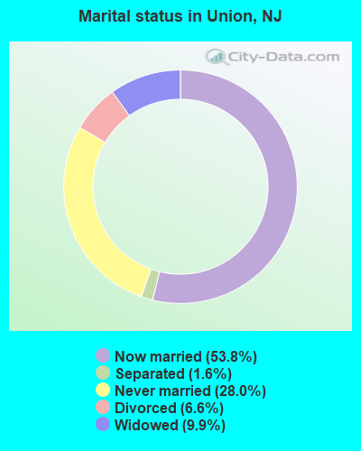
- Never married: 28.0%
- Now married: 53.8%
- Separated: 1.6%
- Widowed: 9.9%
- Divorced: 6.6%
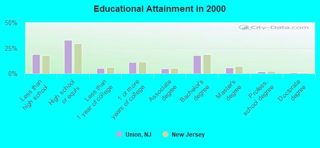
For population 25 years and over in Union:
- High school or higher: 80.9%
- Bachelor's degree or higher: 26.5%
- Graduate or professional degree: 8.4%
- Unemployed: 4.5%
- Mean travel time to work (commute): 27.0 minutes
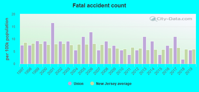
| Here: | 13.2 |
| New Jersey average: | 13.1 |
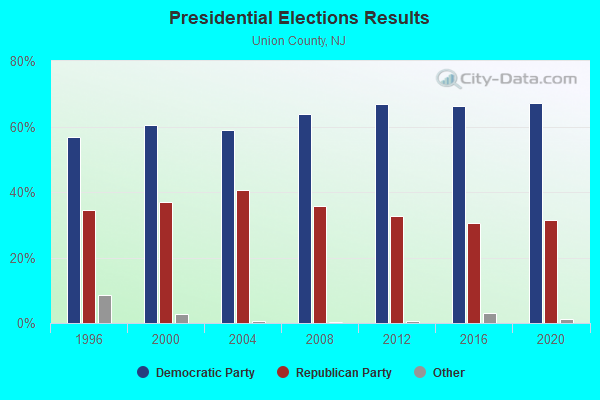
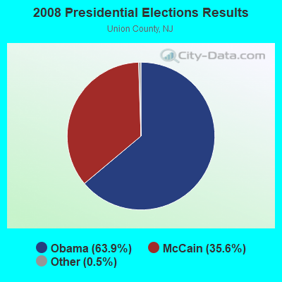
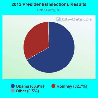
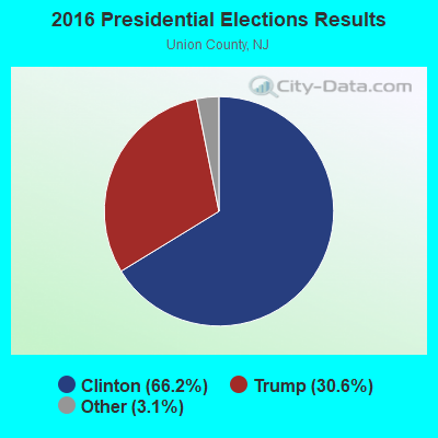

Graphs represent county-level data. Detailed 2008 Election Results
Neighborhoods in Union:
(Union, New Jersey Neighborhood Map)Religion statistics for Union, NJ (based on Union County data)
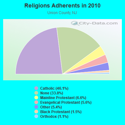
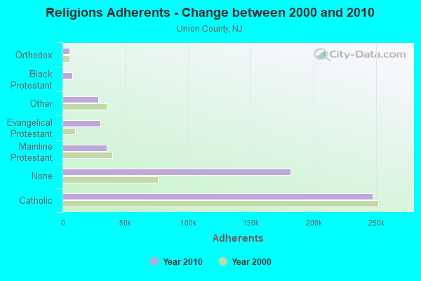
| Religion | Adherents | Congregations |
|---|---|---|
| Catholic | 247,240 | 44 |
| Mainline Protestant | 35,313 | 109 |
| Evangelical Protestant | 30,123 | 129 |
| Other | 28,707 | 52 |
| Black Protestant | 7,858 | 38 |
| Orthodox | 5,717 | 10 |
| None | 181,541 | - |
Food Environment Statistics:
| Union County: | 2.97 / 10,000 pop. |
| New Jersey: | 2.90 / 10,000 pop. |
| Union County: | 0.04 / 10,000 pop. |
| State: | 0.06 / 10,000 pop. |
| Union County: | 1.80 / 10,000 pop. |
| State: | 1.76 / 10,000 pop. |
| Union County: | 0.75 / 10,000 pop. |
| State: | 0.81 / 10,000 pop. |
| This county: | 7.38 / 10,000 pop. |
| New Jersey: | 7.15 / 10,000 pop. |
| This county: | 8.3% |
| New Jersey: | 8.3% |
| Here: | 21.1% |
| State: | 23.3% |
| Here: | 21.4% |
| New Jersey: | 18.0% |
6.55% of this county's 2021 resident taxpayers lived in other counties in 2020 ($90,395 average adjusted gross income)
| Here: | 6.55% |
| New Jersey average: | 6.70% |
0.02% of residents moved from foreign countries ($49 average AGI)
Union County: 0.02% New Jersey average: 0.01%
Top counties from which taxpayers relocated into this county between 2020 and 2021:
| from Essex County, NJ | |
| from Hudson County, NJ | |
| from Middlesex County, NJ |
7.45% of this county's 2020 resident taxpayers moved to other counties in 2021 ($103,155 average adjusted gross income)
| Here: | 7.45% |
| New Jersey average: | 7.02% |
0.01% of residents moved to foreign countries ($81 average AGI)
Union County: 0.01% New Jersey average: 0.02%
Top counties to which taxpayers relocated from this county between 2020 and 2021:
| to Middlesex County, NJ | |
| to Essex County, NJ | |
| to Somerset County, NJ |
| Businesses in Union, NJ | ||||
| Name | Count | Name | Count | |
|---|---|---|---|---|
| 7-Eleven | 6 | McDonald's | 3 | |
| AT&T | 2 | Men's Wearhouse | 1 | |
| Applebee's | 2 | Nike | 3 | |
| Avenue | 1 | Office Depot | 1 | |
| Baskin-Robbins | 1 | Payless | 2 | |
| Blockbuster | 2 | Penske | 1 | |
| Burger King | 1 | PetSmart | 1 | |
| CVS | 3 | Pizza Hut | 2 | |
| Casual Male XL | 1 | Quiznos | 1 | |
| Catherines | 1 | RadioShack | 2 | |
| Chevrolet | 1 | Red Lobster | 1 | |
| Chuck E. Cheese's | 1 | Rite Aid | 2 | |
| Costco | 1 | Ruby Tuesday | 1 | |
| Curves | 1 | Sears | 1 | |
| Dairy Queen | 1 | Sprint Nextel | 1 | |
| Domino's Pizza | 1 | Starbucks | 3 | |
| DressBarn | 1 | Stop & Shop | 1 | |
| Dressbarn | 1 | Subaru | 1 | |
| Dunkin Donuts | 5 | Subway | 4 | |
| Famous Footwear | 1 | T.J.Maxx | 1 | |
| FedEx | 14 | Taco Bell | 1 | |
| Foot Locker | 2 | Target | 1 | |
| Ford | 1 | Toys"R"Us | 2 | |
| GNC | 2 | Travelodge | 1 | |
| GameStop | 2 | U-Haul | 1 | |
| H&R Block | 2 | UPS | 15 | |
| Home Depot | 1 | Verizon Wireless | 2 | |
| Honda | 1 | Volkswagen | 1 | |
| Hyundai | 1 | Walgreens | 1 | |
| IHOP | 1 | Walmart | 1 | |
| KFC | 1 | Wendy's | 1 | |
| Lane Furniture | 2 | White Castle | 1 | |
| Lowe's | 1 | YMCA | 2 | |
| MasterBrand Cabinets | 7 | |||
Strongest AM radio stations in Union:
- WNSW (1430 AM; 5 kW; NEWARK, NJ; Owner: MULTICULTURAL RADIO BROADCASTING INC)
- WMCA (570 AM; 50 kW; NEW YORK, NY; Owner: SALEM MEDIA OF NEW YORK, LLC)
- WOR (710 AM; 50 kW; NEW YORK, NY; Owner: BUCKLEY BROADCASTING CORPORATION)
- WJDM (1530 AM; 10 kW; ELIZABETH, NJ; Owner: RADIO UNICA OF NEW YORK LICENSE CORP)
- WINS (1010 AM; 50 kW; NEW YORK, NY; Owner: INFINITY BROADCASTING OPERATIONS, INC.)
- WEPN (1050 AM; 50 kW; NEW YORK, NY; Owner: NEW YORK AM RADIO, LLC)
- WABC (770 AM; 50 kW; NEW YORK, NY; Owner: WABC-AM RADIO, INC.)
- WADO (1280 AM; 50 kW; NEW YORK, NY; Owner: WADO-AM LICENSE CORP.)
- WBBR (1130 AM; 50 kW; NEW YORK, NY; Owner: BLOOMBERG COMMUNICATIONS INC.)
- WLIB (1190 AM; 30 kW; NEW YORK, NY; Owner: ICBC BROADCAST HOLDINGS-NY, INC.)
- WNYC (820 AM; 10 kW; NEW YORK, NY; Owner: WNYC RADIO)
- WSNR (620 AM; 20 kW; JERSEY CITY, NJ)
- WQEW (1560 AM; 50 kW; NEW YORK, NY; Owner: THE NEW YORK TIMES ELECTRONIC MEDIA COMPANY)
Strongest FM radio stations in Union:
- WRKS (98.7 FM; NEW YORK, NY; Owner: EMMIS RADIO LICENSE CORP OF NEW YORK)
- WSOU (89.5 FM; SOUTH ORANGE, NJ; Owner: SETON HALL UNIVERSITY)
- WNEW (102.7 FM; NEW YORK, NY; Owner: INFINITY BROADCASTING OPERATIONS, INC.)
- WKNJ-FM (90.3 FM; UNION TOWNSHIP, NJ; Owner: KEAN UNIVERSITY)
- WFME (94.7 FM; NEWARK, NJ; Owner: FAMILY STATIONS, INC.)
- WNYC-FM (93.9 FM; NEW YORK, NY; Owner: WNYC RADIO)
- WPAT-FM (93.1 FM; PATERSON, NJ; Owner: WPAT LICENSING, INC.)
- WFMU (91.1 FM; EAST ORANGE, NJ; Owner: AURICLE COMMUNICATIONS)
- WBGO (88.3 FM; NEWARK, NJ; Owner: NEWARK PUBLIC RADIO INC.)
- WQCD (101.9 FM; NEW YORK, NY; Owner: EMMIS RADIO LICENSE CORPORATION)
- WCAA (105.9 FM; NEWARK, NJ; Owner: WADO-AM LICENSE CORP. ("WADO"))
- WBAI (99.5 FM; NEW YORK, NY; Owner: PACIFICA FOUNDATION, INC.)
- WBLS (107.5 FM; NEW YORK, NY; Owner: ICBC BROADCAST HOLDINGS-NY, INC.)
- WLTW (106.7 FM; NEW YORK, NY; Owner: AMFM NEW YORK LICENSES, LLC)
- WQXR-FM (96.3 FM; NEW YORK, NY; Owner: THE NEW YORK TIMES ELECTRONIC MEDIA COMPANY)
- WSKQ-FM (97.9 FM; NEW YORK, NY; Owner: WSKQ LICENSING, INC.)
- WXRK (92.3 FM; NEW YORK, NY; Owner: INFINITY BROADCASTING OPERATIONS, INC.)
- WKTU (103.5 FM; LAKE SUCCESS, NY; Owner: AMFM RADIO LICENSES, LLC)
- WAXQ (104.3 FM; NEW YORK, NY; Owner: AMFM NEW YORK LICENSES, LLC)
- WHTZ (100.3 FM; NEWARK, NJ; Owner: AMFM RADIO LICENSES, L.L.C.)
TV broadcast stations around Union:
- WPXO-LP (Channel 34; EAST ORANGE, NJ; Owner: PAXSON COMMUNICATIONS LPTV, INC.)
- WCBS-TV (Channel 2; NEW YORK, NY; Owner: CBS BROADCASTING INC.)
- WABC-TV (Channel 7; NEW YORK, NY; Owner: AMERICAN BROADCASTING COMPANIES, INC)
- WPIX (Channel 11; NEW YORK, NY; Owner: WPIX, INC.)
- WWOR-TV (Channel 9; SECAUCUS, NJ; Owner: FOX TELEVISION STATIONS, INC.)
- WNYW (Channel 5; NEW YORK, NY; Owner: FOX TELEVISION STATIONS, INC.)
- WPXN-TV (Channel 31; NEW YORK, NY; Owner: PAXSON COMMUNICATIONS LICENSE COMPANY, LLC)
- WNBC (Channel 4; NEW YORK, NY; Owner: NATIONAL BROADCASTING COMPANY, INC.)
- WNET (Channel 13; NEWARK, NJ; Owner: EDUCATIONAL BROADCASTING CORPORATION)
- WXTV (Channel 41; PATERSON, NJ; Owner: WXTV LICENSE PARTNERSHIP, G.P.)
- WNJU (Channel 47; LINDEN, NJ; Owner: WNJU LICENSE CORPORATION)
- WFUT (Channel 68; NEWARK, NJ; Owner: UNIVISION NEW YORK LLC)
- WNYE-TV (Channel 25; NEW YORK, NY; Owner: NEW YORK CITY BOARD OF EDUCATION)
- WXNY-LP (Channel 32; NEW YORK, NY; Owner: ISLAND BROADCASTING COMPANY)
- WKOB-LP (Channel 53; NEW YORK, NY; Owner: WKOB COMMUNICATIONS, INC.)
- WEBR-CA (Channel 17; MANHATTAN, NY; Owner: K LICENSEE INC.)
- WRNN-LP (Channel 57; NYACK, NY; Owner: LP NYACK LIMITED PARTNERSHIP)
- WLBX-LP (Channel 22; CRANFORD, NJ; Owner: RENARD COMMUNICATIONS CORP.)
- W60AI (Channel 60; NEW YORK, NY; Owner: VENTANA TELEVISION, INC.)
- WNXY-LP (Channel 26; NEW YORK, NY; Owner: ISLAND BROADCASTING COMPANY)
- W33BS (Channel 33; DARIEN, CT; Owner: CT&T BROADCASTING, INC.)
- WNYN-LP (Channel 39; NEW YORK, NY; Owner: ISLAND BROADCASTING COMPANY)
- WNYX-LP (Channel 35; NEW YORK, NY; Owner: ISLAND BROADCASTING COMPANY)
- WNJB (Channel 58; NEW BRUNSWICK, NJ; Owner: NEW JERSEY PUBLIC BROADCASTING AUTHORITY)
- W54CZ (Channel 54; MORRISTOWN, NJ; Owner: WLNY-TV, INC.)
- National Bridge Inventory (NBI) Statistics
- 62Number of bridges
- 610ft / 186mTotal length
- $92,673,000Total costs
- 4,162,403Total average daily traffic
- 202,478Total average daily truck traffic
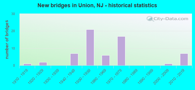
- New bridges - historical statistics
- 11910-1919
- 21920-1929
- 71940-1949
- 211950-1959
- 61960-1969
- 171970-1979
- 12000-2009
- 72010-2019
FCC Registered Commercial Land Mobile Towers: 1 (See the full list of FCC Registered Commercial Land Mobile Towers in Union, NJ)
FCC Registered Private Land Mobile Towers: 5 (See the full list of FCC Registered Private Land Mobile Towers)
FCC Registered Broadcast Land Mobile Towers: 39 (See the full list of FCC Registered Broadcast Land Mobile Towers)
FCC Registered Microwave Towers: 23 (See the full list of FCC Registered Microwave Towers in this town)
FCC Registered Paging Towers: 7 (See the full list of FCC Registered Paging Towers)
FCC Registered Maritime Coast & Aviation Ground Towers: 3 (See the full list of FCC Registered Maritime Coast & Aviation Ground Towers)
FCC Registered Amateur Radio Licenses: 165 (See the full list of FCC Registered Amateur Radio Licenses in Union)
FAA Registered Aircraft Manufacturers and Dealers: 4 (See the full list of FAA Registered Manufacturers and Dealers in Union)
FAA Registered Aircraft: 9 (See the full list of FAA Registered Aircraft)
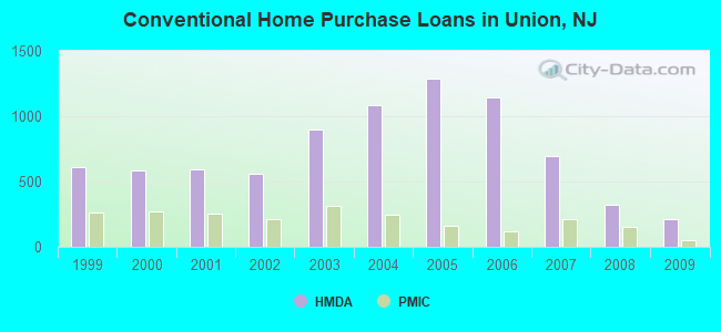
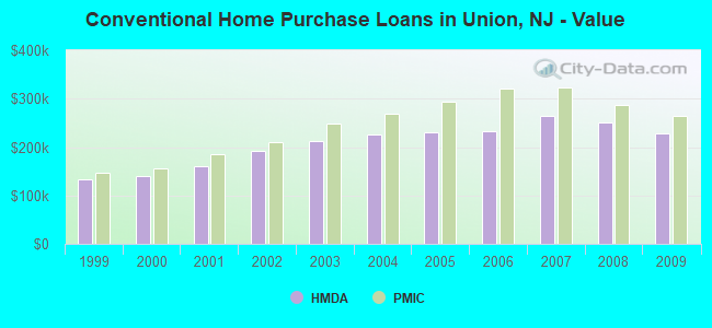
| Home Mortgage Disclosure Act Aggregated Statistics For Year 2009 (Based on 11 full tracts) | ||||||||||||
| A) FHA, FSA/RHS & VA Home Purchase Loans | B) Conventional Home Purchase Loans | C) Refinancings | D) Home Improvement Loans | E) Loans on Dwellings For 5+ Families | F) Non-occupant Loans on < 5 Family Dwellings (A B C & D) | |||||||
|---|---|---|---|---|---|---|---|---|---|---|---|---|
| Number | Average Value | Number | Average Value | Number | Average Value | Number | Average Value | Number | Average Value | Number | Average Value | |
| LOANS ORIGINATED | 269 | $275,204 | 212 | $228,175 | 935 | $240,729 | 58 | $87,845 | 1 | $50,000,000 | 24 | $195,125 |
| APPLICATIONS APPROVED, NOT ACCEPTED | 28 | $269,607 | 30 | $253,067 | 140 | $250,357 | 13 | $61,462 | 0 | $0 | 4 | $201,000 |
| APPLICATIONS DENIED | 67 | $294,597 | 44 | $227,750 | 613 | $263,271 | 62 | $95,774 | 1 | $475,000 | 17 | $173,882 |
| APPLICATIONS WITHDRAWN | 31 | $266,419 | 34 | $220,029 | 283 | $254,922 | 11 | $142,545 | 1 | $1,800,000 | 5 | $196,000 |
| FILES CLOSED FOR INCOMPLETENESS | 33 | $271,970 | 11 | $246,182 | 101 | $275,366 | 5 | $50,000 | 0 | $0 | 2 | $270,000 |
Detailed mortgage data for all 11 tracts in Union, NJ
| Private Mortgage Insurance Companies Aggregated Statistics For Year 2009 (Based on 11 full tracts) | ||||||
| A) Conventional Home Purchase Loans | B) Refinancings | C) Non-occupant Loans on < 5 Family Dwellings (A & B) | ||||
|---|---|---|---|---|---|---|
| Number | Average Value | Number | Average Value | Number | Average Value | |
| LOANS ORIGINATED | 55 | $265,200 | 21 | $292,905 | 0 | $0 |
| APPLICATIONS APPROVED, NOT ACCEPTED | 18 | $278,667 | 16 | $300,375 | 1 | $345,000 |
| APPLICATIONS DENIED | 5 | $262,400 | 7 | $310,429 | 0 | $0 |
| APPLICATIONS WITHDRAWN | 9 | $287,556 | 4 | $319,750 | 0 | $0 |
| FILES CLOSED FOR INCOMPLETENESS | 1 | $293,000 | 2 | $269,000 | 0 | $0 |
2003 - 2018 National Fire Incident Reporting System (NFIRS) incidents
- Fire incident types reported to NFIRS in Union, NJ
- 1,71546.3%Structure Fires
- 1,19432.2%Outside Fires
- 62316.8%Mobile Property/Vehicle Fires
- 1754.7%Other
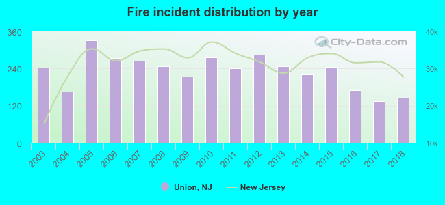 According to the data from the years 2003 - 2018 the average number of fires per year is 232. The highest number of fires - 331 took place in 2005, and the least - 135 in 2017. The data has a declining trend.
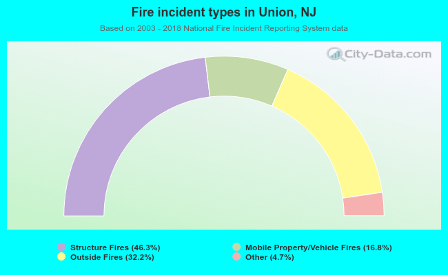 When looking into fire subcategories, the most incidents belonged to: Structure Fires (46.3%), and Outside Fires (32.2%).
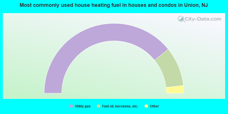
- 78.3%Utility gas
- 18.2%Fuel oil, kerosene, etc.
- 2.5%Electricity
- 0.6%Bottled, tank, or LP gas
- 0.3%Other fuel
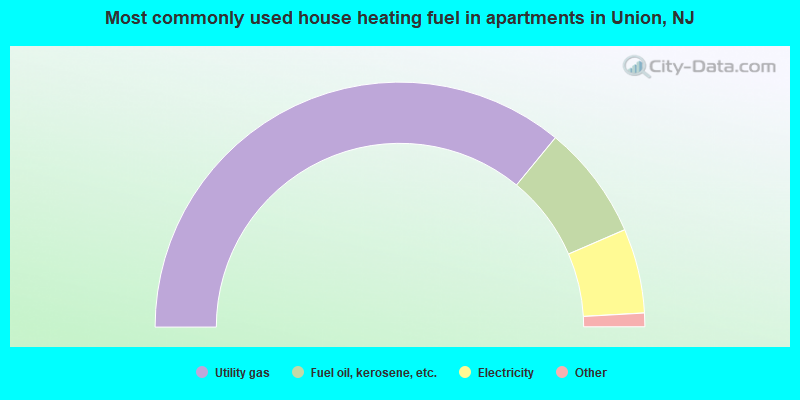
- 71.9%Utility gas
- 15.1%Fuel oil, kerosene, etc.
- 11.2%Electricity
- 1.4%Bottled, tank, or LP gas
- 0.5%No fuel used
Union compared to New Jersey state average:
- Unemployed percentage significantly below state average.
- Hispanic race population percentage below state average.
- Renting percentage significantly below state average.
- Length of stay since moving in significantly above state average.
- Number of rooms per house significantly below state average.
- House age significantly below state average.
- Institutionalized population percentage significantly above state average.
Union on our top lists:
- #1 on the list of "Top 101 cities with largest percentage of males in industries: printing and related support activities (population 50,000+)"
- #1 on the list of "Top 101 cities with largest percentage of females in industries: water transportation (population 50,000+)"
- #2 on the list of "Top 101 cities with largest percentage of females in occupations: other teachers and instructors, education, training, and library occupations (population 50,000+)"
- #3 on the list of "Top 101 cities with the lowest cost per building permit (population 50,000+)"
- #3 on the list of "Top 101 cities with largest percentage of females in industries: metal and metal products (population 50,000+)"
- #3 on the list of "Top 101 cities with largest percentage of males in industries: sporting goods, camera, and hobby and toy stores (population 50,000+)"
- #3 on the list of "Top 101 cities with largest percentage of males in occupations: material recording, scheduling, dispatching, and distributing workers (population 50,000+)"
- #4 on the list of "Top 101 cities with largest percentage of females in occupations: postsecondary teachers (population 50,000+)"
- #4 on the list of "Top 101 cities with largest percentage of females in occupations: secretaries and administrative assistants (population 50,000+)"
- #4 on the list of "Top 101 cities with largest percentage of males in industries: u. s. postal service (population 50,000+)"
- #5 on the list of "Top 101 cities with largest percentage of males in occupations: printing workers (population 50,000+)"
- #5 on the list of "Top 101 cities with largest percentage of females in industries: furniture and home furnishing merchant wholesalers (population 50,000+)"
- #5 on the list of "Top 101 cities with largest percentage of females in occupations: occupational and physical therapist assistants and aides (population 50,000+)"
- #6 on the list of "Top 101 larger cities with the highest real estate taxes percentage (population 50,000+)"
- #7 on the list of "Top 101 cities with largest percentage of females in industries: chemicals (population 50,000+)"
- #8 on the list of "Top 101 cities with largest percentage of females in industries: petroleum and petroleum products merchant wholesalers (population 50,000+)"
- #9 on the list of "Top 101 cities with largest percentage of females in industries: furniture and related product manufacturing (population 50,000+)"
- #9 on the list of "Top 101 cities with largest percentage of males in industries: pharmacies and drug stores (population 50,000+)"
- #9 on the list of "Top 101 cities with largest percentage of females in industries: printing and related support activities (population 50,000+)"
- #10 on the list of "Top 101 cities with largest percentage of males in industries: food and beverage stores (population 50,000+)"
- #67 (07083) on the list of "Top 101 zip codes with the largest percentage of Portuguese first ancestries (pop 5,000+)"
- #15 on the list of "Top 101 counties with the lowest percentage of residents that keep firearms around their homes"
- #17 on the list of "Top 101 counties with the largest decrease in the number of deaths per 1000 residents 2000-2006 to 2007-2013 (pop. 50,000+)"
- #47 on the list of "Top 101 counties with the most Orthodox adherents"
- #53 on the list of "Top 101 counties with the most Catholic adherents"
- #58 on the list of "Top 101 counties with the lowest percentage of residents that drank alcohol in the past 30 days"

|
|
Total of 251 patent applications in 2008-2024.