Welcome to City-Data.com Forum!
U.S. CitiesCity-Data Forum Index
Go Back   City-Data Forum > General Forums > Weather > Hurricanes
 [Register]
Please register to participate in our discussions with 2 million other members - it's free and quick! Some forums can only be seen by registered members. After you create your account, you'll be able to customize options and access all our 15,000 new posts/day with fewer ads.
View detailed profile (Advanced) or search
site with Google Custom Search

Search Forums  (Advanced)
Reply Start New Thread
 
Old 08-06-2012, 08:26 PM
 
Location: Near the Coast SWCT
83,524 posts, read 75,333,969 times
Reputation: 16620

Advertisements

Still Active in Atlantic. Florence dissipated but right behind it is now 92L.

Reply With Quote Quick reply to this message

 
Old 08-07-2012, 12:16 PM
 
Location: New Jersey
559 posts, read 748,398 times
Reputation: 210
And even behind 92L there's a wave that's still in Africa that the GFS model is developing in about 10 days, and behind that ANOTHER wave that's being developed in 2 weeks. African train has officially begun.
Reply With Quote Quick reply to this message
 
Old 08-08-2012, 10:16 AM
 
Location: Eastern NC
20,868 posts, read 23,558,348 times
Reputation: 18814
Quote:
Originally Posted by NWNJ View Post
And even behind 92L there's a wave that's still in Africa that the GFS model is developing in about 10 days, and behind that ANOTHER wave that's being developed in 2 weeks. African train has officially begun.
Yes it has.
Reply With Quote Quick reply to this message
 
Old 08-08-2012, 10:25 AM
 
Location: New Jersey
559 posts, read 748,398 times
Reputation: 210
Maps | Weather Underground

Go to around 372 hours.
Reply With Quote Quick reply to this message
 
Old 08-09-2012, 11:19 AM
 
Location: Near the Coast SWCT
83,524 posts, read 75,333,969 times
Reputation: 16620
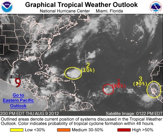
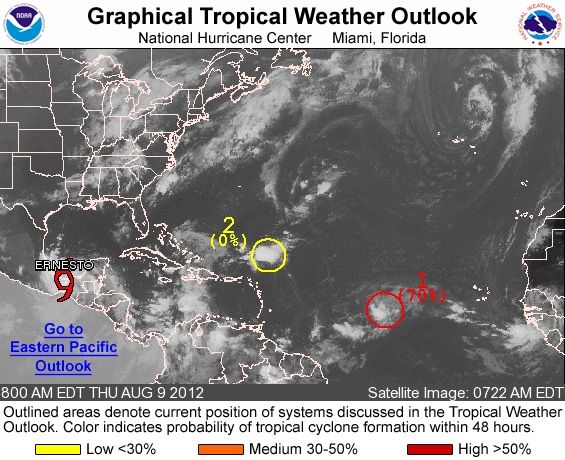
Choo. Choo. While there hasnt been any major hurricanes there is still activity to follow. #2 is interesting here and even another wave coming off Africa right behind it.

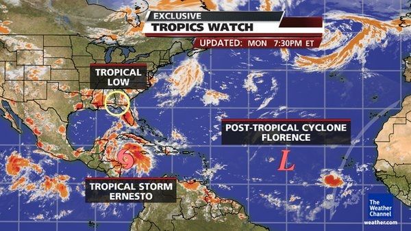
THE NATIONAL HURRICANE CENTER IS ISSUING ADVISORIES ON TROPICAL
STORM ERNESTO...LOCATED NEAR COATZACOALCOS MEXICO.

1. SHOWERS AND THUNDERSTORMS ASSOCIATED WITH A LOW PRESSURE SYSTEM
LOCATED ABOUT 1050 MILES WEST OF THE SOUTHERN CAPE VERDE ISLANDS
CONTINUE TO SHOW LITTLE CHANGE IN ORGANIZATION. UPPER-LEVEL WINDS
APPEAR CONDUCIVE FOR FURTHER DEVELOPMENT AND A TROPICAL DEPRESSION
COULD FORM OVER THE NEXT COUPLE OF DAYS. THIS SYSTEM HAS A HIGH
CHANCE...70 PERCENT...OF BECOMING A TROPICAL CYCLONE DURING THE
NEXT 48 HOURS AS IT MOVES WESTWARD AT ABOUT 15 MPH.

2. A LOW PRESSURE TROUGH...THE REMNANTS OF FLORENCE...IS LOCATED A FEW
HUNDRED MILES NORTHEAST OF THE NORTHERN LEEWARD ISLANDS...AND IS
PRODUCING DISORGANIZED SHOWERS AND THUNDERSTORMS. UPPER-LEVEL WINDS
ARE NOT EXPECTED TO BE CONDUCIVE FOR REDEVELOPMENT. THIS SYSTEM HAS
A LOW CHANCE...NEAR 0 PERCENT...OF BECOMING A TROPICAL CYCLONE
AGAIN DURING THE NEXT 48 HOURS AS IT MOVES NORTHWESTWARD AT ABOUT
20 MPH.

Reply With Quote Quick reply to this message
 
Old 08-09-2012, 12:09 PM
 
Location: New Jersey
559 posts, read 748,398 times
Reputation: 210

There's already a circle around the wave behind 92L and it hasn't even left Africa yet!!! It sure is getting busy out there!
Reply With Quote Quick reply to this message
 
Old 08-09-2012, 01:38 PM
 
Location: Near the Coast SWCT
83,524 posts, read 75,333,969 times
Reputation: 16620
Quote:
Originally Posted by NWNJ View Post
There's already a circle around the wave behind 92L and it hasn't even left Africa yet!!! It sure is getting busy out there!
Wow, I cant keep up. lol

Here's the updated overall look.

3. A TROPICAL WAVE ACCOMPANIED BY AN AREA OF LOW PRESSURE IS
APPROACHING THE WEST COAST OF AFRICA WITH MINIMAL SHOWER AND
THUNDERSTORM ACTIVITY. SOME DEVELOPMENT OF THIS SYSTEM IS POSSIBLE
OVER THE NEXT COUPLE OF DAYS AS IT MOVES WESTWARD AT 10 TO 15 MPH.
THIS SYSTEM HAS A LOW CHANCE...20 PERCENT...OF BECOMING A TROPICAL
CYCLONE DURING THE NEXT 48 HOURS.

Reply With Quote Quick reply to this message
 
Old 08-10-2012, 01:01 PM
 
Location: Near the Coast SWCT
83,524 posts, read 75,333,969 times
Reputation: 16620
Reply With Quote Quick reply to this message
 
Old 08-10-2012, 07:36 PM
 
Location: New Jersey
559 posts, read 748,398 times
Reputation: 210
TD7 STILL hasn't become Gordon yet and is supposed to dissipate soon, and 93L is now only 20% chance instead of 50%. So much for activity... lol.
Reply With Quote Quick reply to this message
 
Old 08-11-2012, 09:01 PM
 
Location: New Jersey
559 posts, read 748,398 times
Reputation: 210
Biggest wave I've ever seen coming off Africa, the one in the middle. Also the one just coming off apparently is spinning clockwise... what the??


And it could be the one that turns into this... mother of god... Isaac

Last edited by NWNJ; 08-11-2012 at 10:27 PM..
Reply With Quote Quick reply to this message
Please register to post and access all features of our very popular forum. It is free and quick. Over $68,000 in prizes has already been given out to active posters on our forum. Additional giveaways are planned.

Detailed information about all U.S. cities, counties, and zip codes on our site: City-data.com.


Reply
Please update this thread with any new information or opinions. This open thread is still read by thousands of people, so we encourage all additional points of view.

Quick Reply
Message:


Over $104,000 in prizes was already given out to active posters on our forum and additional giveaways are planned!

Go Back   City-Data Forum > General Forums > Weather > Hurricanes
Similar Threads

All times are GMT -6. The time now is 12:05 PM.

© 2005-2024, Advameg, Inc. · Please obey Forum Rules · Terms of Use and Privacy Policy · Bug Bounty

City-Data.com - Contact Us - Archive 1, 2, 3, 4, 5, 6, 7, 8, 9, 10, 11, 12, 13, 14, 15, 16, 17, 18, 19, 20, 21, 22, 23, 24, 25, 26, 27, 28, 29, 30, 31, 32, 33, 34, 35, 36, 37 - Top