Please register to participate in our discussions with 2 million other members - it's free and quick! Some forums can only be seen by registered members. After you create your account, you'll be able to customize options and access all our 15,000 new posts/day with fewer ads.
Some cold is seeping into the Northeast this morning. -10's are popping up, and Boston has gotten down to +7F.
definitely colder than other days today, I turned the heat on my car while yesterday was barely using it.. 26°F at 10 am on Long Island, not warming up. 28°F out. Dew point 13°F but it doesn't drop to the dew point at night for some reason.
-5°F this morning back in Mass. 12°F now. Only 100 miles north.
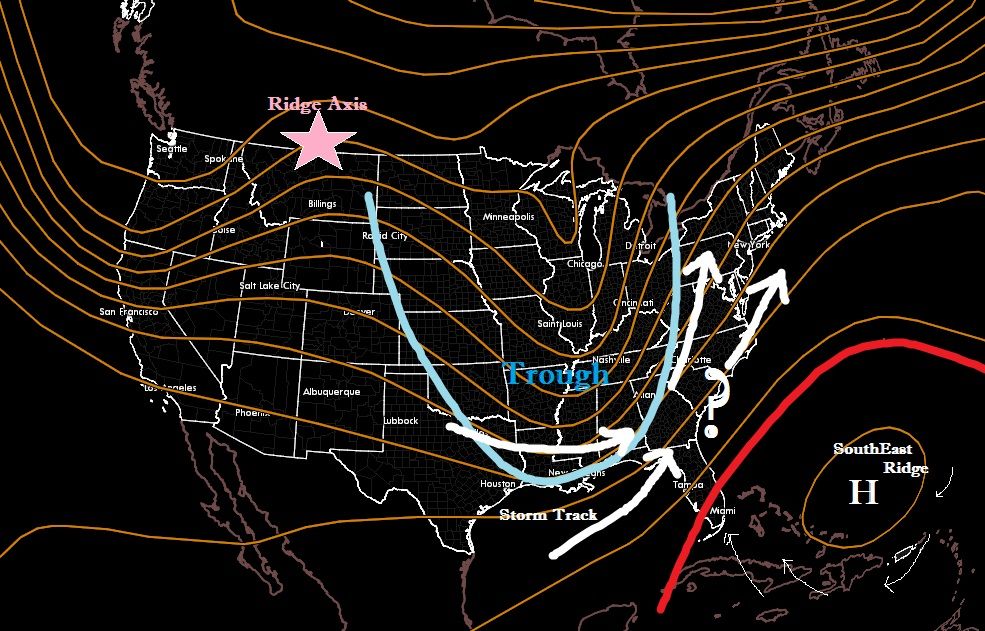
The dreaded SouthEast Ridge for cold weather fans can actually benefit them.
One thing I'm noticing lately is the strength of the SouthEast ridge which is pumping south air into the East. One way to break down this ridge is a series of storms cutting through the great lakes to knock down and weaken the ridge.
However.. Sometimes the Ridge actually helps get snowstorms on the East coast. *Remember*, storm tracks are typically on the right side of troughs (look at 500mb level for this)
If the trough digs enough and the SouthEast Ridge doesnt budge, then the track will come up the East coast somewhere.
One rule of thumb I like to follow is that the Ridge Axis of the Ridge out West has to be centered over Montana. Any shift left and the track goes to Great Lakes. Any shift right and the storm goes OTS.
Here's a visual of what I'm talking about.
Now if that SouthEast ridge is too weak then other factors come in play. Maybe there's too strong Surface High pressure over the NorthEast and ther storms get supressed to the south.
And of course placement of the SouthEast Ridge matters and also how broad the trough is.
But now hopefully you have an idea how the 500mb level plays out with storms. A reason why I love winter. So much more interesting because theres so much more things involved.
Middle of the afternoon and only 15°F (-9°C) back home in Massachusetts. Rest of the week is forecast to have highs 30 and above, getting closer to 40 starting on Tuesday.
Interesting map, though for New England the ridge would have to be rather far to the east to get snow.
Not nessecarily as the flow would be southwest to NorthEast so the path would be Appalacians or Coastal. New England could have the benefit cold air in place for big snowstorms.
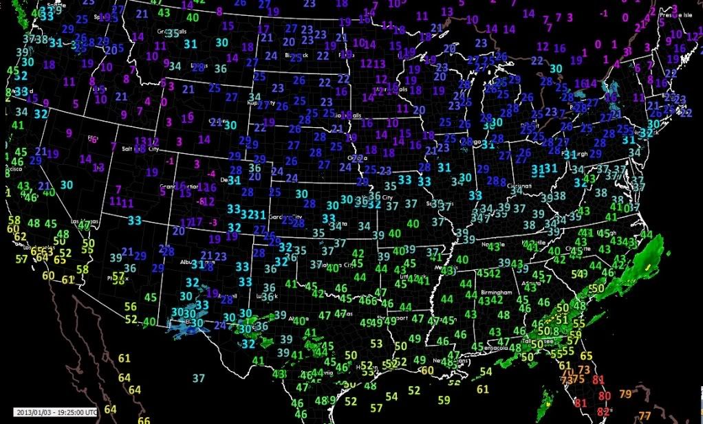
Here's a look at the current 500mb setup. Reason why we're cold? NorthWest flow aloft and a snowpack helping. Follow the flow. Reason why the storm down south is staying down south is the flow.
The only snow from this setup today would be Clippers for us. Any storm that forms down south is being Supressed.
Current Temps. Hasnt made it out of single digits in Northern New England while Florida is baking in the 80s.
And use this cool link to see the current 500mb which includes a little of Canada. Pick drop down choice of FL180 for the current 500mb. ADDS - Winds/Temps
Notice Calgary on top of the south flow. Usually Ridges dont go that far north but I havent followed Canada weather much so not sure.
Please register to post and access all features of our very popular forum. It is free and quick. Over $68,000 in prizes has already been given out to active posters on our forum. Additional giveaways are planned.
Detailed information about all U.S. cities, counties, and zip codes on our site: City-data.com.

 Please register to participate in our discussions with 2 million other members - it's free and quick! Some forums can only be seen by registered members. After you create your account, you'll be able to customize options and access all our 15,000 new posts/day with fewer ads.