Please register to participate in our discussions with 2 million other members - it's free and quick! Some forums can only be seen by registered members. After you create your account, you'll be able to customize options and access all our 15,000 new posts/day with fewer ads.
The backside of the same storm system that's producing the severe storms in the East is producing some unusually heavy and persistent rains in the High Plains and points west - for the past 24 hours a good chunk of Montana has received more than an inch of rain according to doppler radar estimates. The high elevations are cold enough to turn the precip over to snow, but this is a rain event more than a snow event.
In the map below greens represent a trace to 1 inch, yellow represents 1-2 inches, orange represents 2-3 inches, and the pink bullseye is 3+ inches.
Quote:
Originally Posted by Cambium
Windsor Locks, BDL monthly temp departure went from -0.1 yesterday to now above normal at 0.4 for the month.
I just call that "near normal" - a few tenths of a degree plus or minus doesn't make any difference in my view. I also think the addition of a near-normal classification increases accuracy when looking at monthly streaks - there are situations where you might spend 9 months below normal but 3 months were -0.3 or some such and think it was really cold but it wasn't. Ditto for heat/above normal.
Quote:
It's something I always think about when looking at stats and maps regarding departures but we have no choice I guess. Just keep this in mind next time you look at them. Was there a few days at the end that changed us into below or above normal for the month?
Indeed. Ideally we would have a map with number of days above normal, number of days below normal, absolute monthly maximum, absolute monthly minimum, standard deviation, and a line graph showing temperatures for every weather station. Come to think of it I don't think all of that could fit on one map - perhaps a battery of about 10 maps would suffice .
More maps of average dew points would be good as well.
Latest model outputs for the UK show a much toned down first week of June in regards to temperatures, nothing exceeding 16-17°C in my location with quite cool maritime air being brought down by the HP cell. No warm sunny spell whatsoever from what I can make out as any average/above average temperatures look delayed once more to about 168 hours or so into the run as ad infinitum. I suppose the consolation is that at least we aren't getting a June like last year's.
Well the forecast for the first week of June has been downgraded to complete CRAP. Highs of 15°C every day and nothing warm AT ALL. Ridiculous. How on earth did people get the idea we would be having a warm spell? Nothing of the sort at all. The latest chart outputs are disgusting. At least here it looks pathetic.
GFS has lost the plot again. Getting an air frost in June has occurred before, but they're very rare away from frost hollows in northern England and Scotland. I'll eat my entire wardrobe if this comes to pass.
The forecast for here looks average, highs between 17 and 20C and lows around 9C.
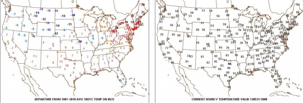
anyone notice that interior New England got the hottest temperatures of the heat wave?
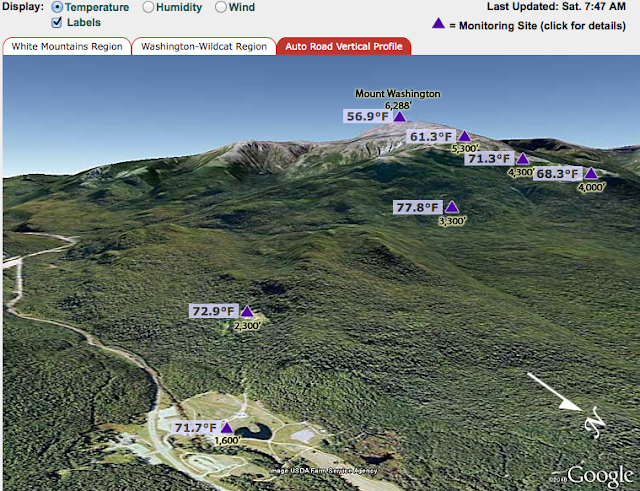
From Mt. Washington yesterday?
Currently, the temperature outside is a balmy 59 degrees F. After the fog cleared this morning, the clouds began to billow, and eventually blossomed into scattered showers and thunderstorms across the White Mountains.
Today and tomorrow have been declared 'Air Quality Action Days' by the New Hampshire Department of Environmental Services (NHDES), due to expected unhealthy levels of ground-level ozone over elevations of 3000 feet. While the mercury is reaching up to 60 degrees F up on the summit, temperatures in the valley today are soaring to near 90 degrees F!
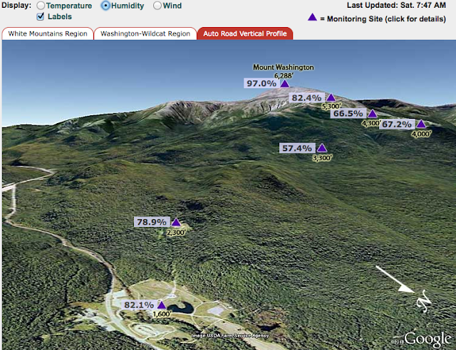
Right now at the summit at 7:45 AM, it's already 57°F, foggy with a brisk wind at 31 mph. At 3300 feet, it's 78°F. Hotter than here (at nearly sea level at further south. Look at this wacky temperature profile:
and the humidity. Driest obviously at 3300 feet:
Last edited by nei; 06-01-2013 at 06:08 AM..
Please register to post and access all features of our very popular forum. It is free and quick. Over $68,000 in prizes has already been given out to active posters on our forum. Additional giveaways are planned.
Detailed information about all U.S. cities, counties, and zip codes on our site: City-data.com.

 Please register to participate in our discussions with 2 million other members - it's free and quick! Some forums can only be seen by registered members. After you create your account, you'll be able to customize options and access all our 15,000 new posts/day with fewer ads.


 .
.