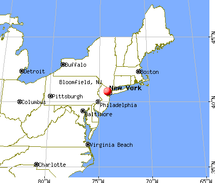
Bloomfield, New Jersey
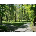
Bloomfield: Brookdale Park- Bloomfield, NJ
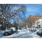
Bloomfield: Typical Bloomfield Neighborhood
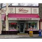
Bloomfield: Holsten's Ice Cream Parlor (where the las episode of The Sopranos was shot) Bloomfield, NJ
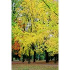
Bloomfield: Fall in Bloomfield, NJ
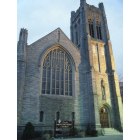
Bloomfield: Park United Methodist Church Bloomfield, NJ

Bloomfield: Brookside Park
- add
your


Submit your own pictures of this place and show them to the world
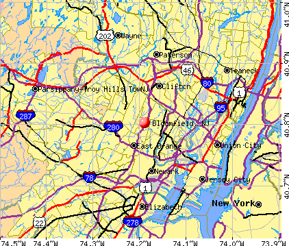
- OSM Map
- General Map
- Google Map
- MSN Map
| Males: 22,031 | |
| Females: 24,257 |
| Median resident age: | 37.1 years |
| New Jersey median age: | 36.7 years |
Zip codes: 07003.
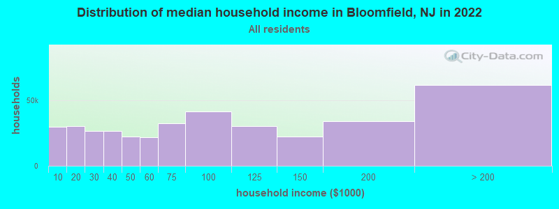
| Bloomfield: | $88,919 |
| NJ: | $96,346 |
Estimated per capita income in 2022: $49,249 (it was $26,049 in 2000)
Bloomfield CDP income, earnings, and wages data
Estimated median house or condo value in 2022: $435,616 (it was $166,100 in 2000)
| Bloomfield: | $435,616 |
| NJ: | $428,900 |
Mean prices in 2022: all housing units: $574,104; detached houses: $657,086; townhouses or other attached units: $439,629; in 2-unit structures: $368,927; in 3-to-4-unit structures: $409,981; in 5-or-more-unit structures: $367,645; mobile homes: $225,735
Detailed information about poverty and poor residents in Bloomfield, NJ


- 30,03663.0%White alone
- 6,90114.5%Hispanic
- 5,33211.2%Black alone
- 3,9808.3%Asian alone
- 1,0572.2%Two or more races
- 2960.6%Other race alone
- 510.1%American Indian alone
- 300.06%Native Hawaiian and Other
Pacific Islander alone
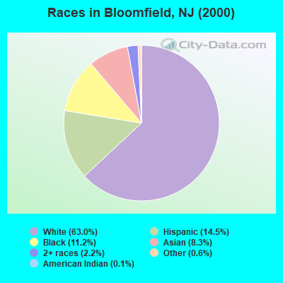
Races in Bloomfield detailed stats: ancestries, foreign born residents, place of birth
According to our research of New Jersey and other state lists, there were 16 registered sex offenders living in Bloomfield, New Jersey as of April 29, 2024.
The ratio of all residents to sex offenders in Bloomfield is 2,893 to 1.
The ratio of registered sex offenders to all residents in this city is lower than the state average.
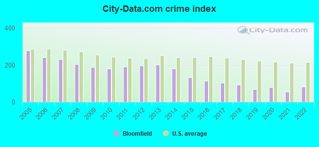
The City-Data.com crime index weighs serious crimes and violent crimes more heavily. Higher means more crime, U.S. average is 246.1. It adjusts for the number of visitors and daily workers commuting into cities.
- means the value is smaller than the state average.- means the value is bigger than the state average.
- means the value is much bigger than the state average.
Crime rate in Bloomfield detailed stats: murders, rapes, robberies, assaults, burglaries, thefts, arson
Full-time law enforcement employees in 2021, including police officers: 147 (123 officers - 113 male; 10 female).
| Officers per 1,000 residents here: | 2.36 |
| New Jersey average: | 5.53 |
 Recent articles from our blog. Our writers, many of them Ph.D. graduates or candidates, create easy-to-read articles on a wide variety of topics.


 | Wholesome news story - Bloomfield teen accepted into 7 Ivy League schools (46 replies) |
| Bloomfield in 2021 (14 replies) |
| Lead in the Water: Bloomfield (1 reply) |
| Daycares in Montclair, Glen Ridge, and Bloomfield (0 replies) |
| Bloomfield, NJ in 2020 (9 replies) |
| The Green at Bloomfield (1 reply) |
Latest news from Bloomfield, NJ collected exclusively by city-data.com from local newspapers, TV, and radio stations
Ancestries: Italian (26.4%), Irish (13.9%), German (10.2%), Polish (7.0%), English (4.2%), West Indian (2.2%).
Current Local Time: EST time zone
Incorporated in 1812
Elevation: 131 feet
Land area: 5.32 square miles.
Population density: 8,699 people per square mile (high).
10,892 residents are foreign born (9.1% Latin America, 6.7% Asia, 5.9% Europe).
| This place: | 22.8% |
| New Jersey: | 17.5% |
| Bloomfield CDP: | 3.4% ($5,567) |
| New Jersey: | 2.4% ($4,047) |
Nearest city with pop. 50,000+: East Orange, NJ  (2.8 miles , pop. 69,824).
Nearest city with pop. 200,000+: Newark, NJ (4.7 miles , pop. 273,546).
Nearest city with pop. 1,000,000+: Manhattan, NY (11.5 miles , pop. 1,537,195).
Nearest cities:
), ), Latitude: 40.80 N, Longitude: 74.19 W
Daytime population change due to commuting: -11,059 (-23.2%)
Workers who live and work in this place: 3,333 (13.8%)
Area codes: 973, 862
Bloomfield, New Jersey accommodation & food services, waste management - Economy and Business Data
| Here: | 5.6% |
| New Jersey: | 4.5% |

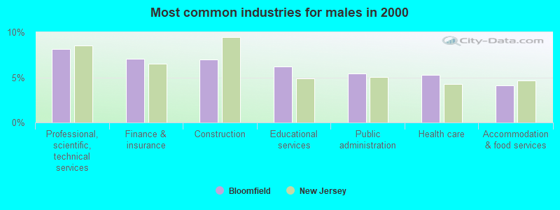
- Health care (11.2%)
- Educational services (9.0%)
- Finance & insurance (8.6%)
- Professional, scientific, technical services (8.4%)
- Public administration (4.4%)
- Construction (4.1%)
- Accommodation & food services (3.5%)
- Professional, scientific, technical services (8.2%)
- Finance & insurance (7.0%)
- Construction (6.9%)
- Educational services (6.2%)
- Public administration (5.4%)
- Health care (5.3%)
- Accommodation & food services (4.1%)
- Health care (17.4%)
- Educational services (12.0%)
- Finance & insurance (10.3%)
- Professional, scientific, technical services (8.6%)
- Chemicals (3.5%)
- Administrative & support & waste management services (3.4%)
- Public administration (3.3%)
- Other office and administrative support workers, including supervisors (5.4%)
- Secretaries and administrative assistants (4.4%)
- Computer specialists (3.7%)
- Other management occupations, except farmers and farm managers (3.4%)
- Other production occupations, including supervisors (3.4%)
- Other sales and related occupations, including supervisors (3.2%)
- Driver/sales workers and truck drivers (3.0%)

- Driver/sales workers and truck drivers (5.8%)
- Computer specialists (5.4%)
- Electrical equipment mechanics and other installation, maintenance, and repair workers, including supervisors (4.7%)
- Material recording, scheduling, dispatching, and distributing workers (4.3%)
- Other management occupations, except farmers and farm managers (3.9%)
- Other production occupations, including supervisors (3.9%)
- Other sales and related occupations, including supervisors (3.7%)
- Secretaries and administrative assistants (8.6%)
- Other office and administrative support workers, including supervisors (7.9%)
- Registered nurses (4.9%)
- Preschool, kindergarten, elementary, and middle school teachers (4.5%)
- Customer service representatives (3.8%)
- Retail sales workers, except cashiers (3.5%)
- Information and record clerks, except customer service representatives (3.2%)
Average climate in Bloomfield, New Jersey
Based on data reported by over 4,000 weather stations
|
|


(lower is better)
Air Quality Index (AQI) level in 2023 was 111. This is significantly worse than average.
| City: | 111 |
| U.S.: | 73 |
Carbon Monoxide (CO) [ppm] level in 2023 was 0.363. This is significantly worse than average. Closest monitor was 3.2 miles away from the city center.
| City: | 0.363 |
| U.S.: | 0.251 |
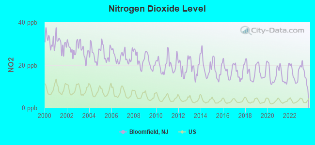
Nitrogen Dioxide (NO2) [ppb] level in 2023 was 15.5. This is significantly worse than average. Closest monitor was 4.7 miles away from the city center.
| City: | 15.5 |
| U.S.: | 5.1 |
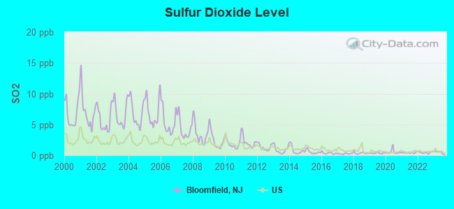
Sulfur Dioxide (SO2) [ppb] level in 2023 was 0.512. This is significantly better than average. Closest monitor was 3.2 miles away from the city center.
| City: | 0.512 |
| U.S.: | 1.515 |
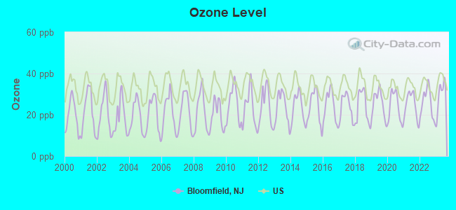
Ozone [ppb] level in 2023 was 29.3. This is about average. Closest monitor was 3.2 miles away from the city center.
| City: | 29.3 |
| U.S.: | 33.3 |
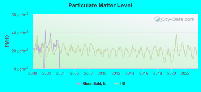
Particulate Matter (PM10) [µg/m3] level in 2003 was 26.9. This is worse than average. Closest monitor was 5.7 miles away from the city center.
| City: | 26.9 |
| U.S.: | 19.2 |

Particulate Matter (PM2.5) [µg/m3] level in 2023 was 9.12. This is about average. Closest monitor was 5.2 miles away from the city center.
| City: | 9.12 |
| U.S.: | 8.11 |
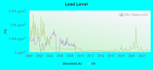
Lead (Pb) [µg/m3] level in 2008 was 0.0125. This is worse than average. Closest monitor was 4.5 miles away from the city center.
| City: | 0.0125 |
| U.S.: | 0.0093 |
Tornado activity:
Bloomfield-area historical tornado activity is near New Jersey state average. It is 35% smaller than the overall U.S. average.
On 5/28/1973, a category F3 (max. wind speeds 158-206 mph) tornado 16.3 miles away from the Bloomfield place center caused between $50,000 and $500,000 in damages.
On 5/28/1973, a category F3 tornado 28.0 miles away from the place center injured 12 people and caused between $50,000 and $500,000 in damages.
Earthquake activity:
Bloomfield-area historical earthquake activity is significantly above New Jersey state average. It is 68% smaller than the overall U.S. average.On 8/23/2011 at 17:51:04, a magnitude 5.8 (5.8 MW, Depth: 3.7 mi, Class: Moderate, Intensity: VI - VII) earthquake occurred 283.2 miles away from Bloomfield center
On 10/7/1983 at 10:18:46, a magnitude 5.3 (5.1 MB, 5.3 LG, 5.1 ML) earthquake occurred 218.0 miles away from the city center
On 1/16/1994 at 01:49:16, a magnitude 4.6 (4.6 MB, 4.6 LG, Depth: 3.1 mi, Class: Light, Intensity: IV - V) earthquake occurred 102.5 miles away from the city center
On 4/20/2002 at 10:50:47, a magnitude 5.3 (5.3 ML, Depth: 3.0 mi) earthquake occurred 257.8 miles away from the city center
On 4/20/2002 at 10:50:47, a magnitude 5.2 (5.2 MB, 4.2 MS, 5.2 MW, 5.0 MW) earthquake occurred 255.9 miles away from the city center
On 1/16/1994 at 00:42:43, a magnitude 4.2 (4.2 MB, 4.0 LG, Depth: 3.1 mi) earthquake occurred 101.0 miles away from the city center
Magnitude types: regional Lg-wave magnitude (LG), body-wave magnitude (MB), local magnitude (ML), surface-wave magnitude (MS), moment magnitude (MW)
Natural disasters:
The number of natural disasters in Essex County (30) is a lot greater than the US average (15).Major Disasters (Presidential) Declared: 19
Emergencies Declared: 10
Causes of natural disasters: Floods: 8, Hurricanes: 7, Storms: 7, Heavy Rains: 4, Snowstorms: 4, Winter Storms: 3, Blizzards: 2, Water Shortages: 2, Power Outage: 1, Tornado: 1, Tropical Storm: 1, Wind: 1, Other: 3 (Note: some incidents may be assigned to more than one category).
Main business address for: ALFACELL CORP (BIOLOGICAL PRODUCTS (NO DIAGNOSTIC SUBSTANCES)).
Hospitals and medical centers in Bloomfield:
Heliports located in Bloomfield:
Amtrak stations near Bloomfield:
- 5 miles: NEWARK (RAYMOND PLAZA WEST) . Services: ticket office, fully wheelchair accessible, enclosed waiting area, public restrooms, public payphones, snack bar, ATM, paid short-term parking, paid long-term parking, call for car rental service, taxi stand, intercity bus service, public transit connection.
- 8 miles: NEWARK INTERNATIONAL AIRPORT (NEWARK, ) . Services: ticket office, enclosed waiting area, public restrooms, public payphones.
- 11 miles: NEW YORK (PENN STA) (NEW YORK, 7TH AVE. & W. 32ND ST.) . Services: ticket office, fully wheelchair accessible, enclosed waiting area, public restrooms, public payphones, full-service food facilities, snack bar, vending machines, ATM, paid short-term parking, paid long-term parking, call for car rental service, taxi stand, public transit connection.
Colleges/Universities in Bloomfield:
Colleges/universities with over 2000 students nearest to Bloomfield:
- Montclair State University (about 4 miles; Montclair, NJ; Full-time enrollment: 16,277)
- University of Medicine and Dentistry of New Jersey (about 5 miles; Newark, NJ; FT enrollment: 3,210)
- New Jersey Institute of Technology (about 5 miles; Newark, NJ; FT enrollment: 8,212)
- Rutgers University-Newark (about 5 miles; Newark, NJ; FT enrollment: 9,869)
- Essex County College (about 5 miles; Newark, NJ; FT enrollment: 9,595)
- Seton Hall University (about 6 miles; South Orange, NJ; FT enrollment: 7,742)
- Berkeley College-Woodland Park (about 7 miles; Woodland Park, NJ; FT enrollment: 2,938)
Public high schools in Bloomfield:
- BLOOMFIELD HIGH SCHOOL (Students: 1,625, Location: 160 BROAD STREET, Grades: 9-12)
- BLOOMFIELD TECH (Location: 209 FRANKLIN STREET, Grades: 9-12)
Private high school in Bloomfield:
Biggest public elementary/middle schools in Bloomfield:
- BLOOMFIELD MIDDLE SCHOOL (Students: 821, Location: 60 HUCK ROAD, Grades: 7-8)
- FAIRVIEW ELEMENTARY (Students: 478, Location: 376 BERKELEY AVENUE, Grades: PK-6)
- BERKELEY ELEMENTARY (Students: 446, Location: 351 BLOOMFIELD AVE, Grades: PK-6)
- DEMAREST ELEMENTARY (Students: 445, Location: 465 BROUGHTON AVE, Grades: PK-6)
- CARTERET ELEMENTARY (Students: 437, Location: 158 GROVE STREET, Grades: PK-6)
- OAK VIEW ELEMENTARY (Students: 358, Location: 150 GARRABRANT AVENUE, Grades: PK-6)
- BROOKDALE ELEMENTARY (Students: 301, Location: 1230 BROAD STREET, Grades: PK-6)
- WATSESSING ELEMENTARY (Students: 297, Location: 71 PROSPECT STREET, Grades: PK-6)
- THE EARLY CHILDHOOD CENTER @ FOREST GLEN (Location: 280 DAVEY STREET, Grades: PK-2)
- FRANKLIN ELEMENTARY (Location: 85 CURTIS STREET, Grades: PK-6)
Private elementary/middle schools in Bloomfield:
- ST THOMAS THE APOSTLE SCHOOL (Students: 243, Location: 50 BYRD AVE, Grades: PK-8)
- LOOKING GLASS CHILDREN'S CENTER (Students: 57, Location: 16 BELLEVUE AVE, Grades: PK-1)
- EACH 1 TEACH 1 ACADEMY (Students: 42, Location: 59 DODD STREET, Grades: PK-T1)
- MOUNT CARMEL GUILD SCHOOL & PRESCHOOL (Students: 32, Location: 236 HOOVER AVE, Grades: UG-2)
Points of interest:
Notable locations in Bloomfield: Forest Hill Field Club (A), Glen Ridge Country Club (B), Rowe Street Station (C), Ridge Country Club (D), Parkway Industrial Center (E), Bloomfield Station (F), Bloomfield Ambulance (G), Bloomfield Volunteer Emergency Squad (H), Bloomfield Fire Department Station 3 (I), Bloomfield Fire Department Station 4 (J), Bloomfield Fire Department Station 2 (K), Bloomfield Fire Department (L). Display/hide their locations on the map
Main business address in Bloomfield: ALFACELL CORP (A). Display/hide its location on the map
Churches in Bloomfield include: Bethany United Presbyterian Church (A), Advent Episcopal Church (B), Bethel Church of Love and Praise (C), Bloomfield Presbyterian Church (D), Brookdale Baptist Church (E), Brookdale Reformed Church (F), First Baptist Church (G), Korean United Presbyterian Church (H), Park United Methodist Church (I). Display/hide their locations on the map
Cemeteries: Bloomfield Cemetery (1), Mount Olivet Cemetery (2). Display/hide their locations on the map
Lake: Clarks Pond (A). Display/hide its location on the map
Parks in Bloomfield include: Brookside Park (1), Foley Field (2), Pulaski Park (3), Vassar Field (4), Brookdale County Park (5), Watsessing Park (6), Brookdale Park (7). Display/hide their locations on the map
Tourist attractions: Historical Society of Bloomfield (Museums; 90 Broad Street), Oakeside Bloomfield Cultural Center (240 Belleville Avenue), Club A B C Tours (Tours & Charters; 200 Broadacres Drive Suite 2).
Courts: Nj State - Judiciary Department Court- Appellate Div- Judges- Judge Barbara Byrd We (155 Morris Avenue), Montclair Township - Court Clerk (647 Bloomfield Avenue), Nj State - Judiciary Department Court- Appellate Div- Judges- Judge Rudy C Col (155 Morris Avenue).
Birthplace of: Doug Brien - 2005 NFL player (Chicago Bears, born: Nov 24, 1970), Hank Borowy - Major League Baseball pitcher, Jack Lowe, Jr. - Businessman, Todd Edwards - Electronic musician, Da-Shawn Dwight - College basketball player (Quinnipiac Bobcats), Don Savage - Baseball player, Jamar Nutter - College basketball player (Seton Hall Pirates), Jim Kelly (baseball) - Major League Baseball player, Robert Gimson - Football player, Seymour Parker Gilbert - Diplomat.
Drinking water stations with addresses in Bloomfield and their reported violations in the past:
BLOOMFIELD WATER DEPARTMENT (Population served: 45,061, Purch surface water):Past health violations:Past monitoring violations:
- MCL, Average - Between JAN-2012 and MAR-2012, Contaminant: TTHM. Follow-up actions: St Public Notif requested (FEB-09-2012), St Formal NOV issued (FEB-09-2012), St Public Notif received (MAR-09-2012), St Compliance achieved (MAR-01-2013)
- MCL, Average - Between OCT-2011 and DEC-2011, Contaminant: TTHM. Follow-up actions: St Public Notif requested (DEC-02-2011), St Formal NOV issued (DEC-02-2011), St Public Notif received (MAR-09-2012), St Compliance achieved (MAR-01-2013)
- MCL, Average - Between JUL-2011 and SEP-2011, Contaminant: TTHM. Follow-up actions: St Public Notif requested (OCT-28-2011), St Formal NOV issued (OCT-28-2011), St Public Notif received (MAR-09-2012), St Compliance achieved (MAR-01-2013)
- MCL, Monthly (TCR) - In JUL-2009, Contaminant: Coliform. Follow-up actions: St Public Notif requested (AUG-14-2009), St Formal NOV issued (AUG-14-2009), St Compliance achieved (AUG-31-2009), St Public Notif received (AUG-31-2009)
- MCL, Monthly (TCR) - In JUN-2009, Contaminant: Coliform. Follow-up actions: St Public Notif requested (JUL-21-2009), St Formal NOV issued (JUL-21-2009), St Public Notif received (JUL-30-2009), St Compliance achieved (AUG-31-2009)
- MCL, Average - Between OCT-2005 and DEC-2005, Contaminant: Total Haloacetic Acids (HAA5). Follow-up actions: St Compliance achieved (FEB-02-2006), St Intentional no-action (MAR-31-2006)
- MCL, Average - Between APR-2005 and JUN-2005, Contaminant: Total Haloacetic Acids (HAA5). Follow-up actions: St Compliance achieved (FEB-02-2006)
- Monitoring and Reporting (DBP) - Between JAN-2007 and MAR-2007, Contaminant: TTHM. Follow-up actions: St Formal NOV issued (DEC-02-2009), St Public Notif requested (DEC-02-2009)
- Monitoring and Reporting (DBP) - Between JAN-2007 and MAR-2007, Contaminant: Total Haloacetic Acids (HAA5). Follow-up actions: St Formal NOV issued (DEC-02-2009), St Public Notif requested (DEC-02-2009)
- Monitoring and Reporting (DBP) - Between OCT-2006 and DEC-2006, Contaminant: Total Haloacetic Acids (HAA5). Follow-up actions: St Compliance achieved (FEB-12-2007), St Public Notif requested (DEC-02-2009), St Formal NOV issued (DEC-02-2009)
- Monitoring and Reporting (DBP) - Between OCT-2006 and DEC-2006, Contaminant: TTHM. Follow-up actions: St Compliance achieved (FEB-12-2007), St Public Notif requested (DEC-02-2009), St Formal NOV issued (DEC-02-2009)
- Monitoring and Reporting (DBP) - Between JUL-2006 and SEP-2006, Contaminant: TTHM. Follow-up actions: St Compliance achieved (NOV-13-2006), St Public Notif requested (DEC-02-2009), St Formal NOV issued (DEC-02-2009)
- One minor monitoring violation
- 13 other older monitoring violations
| This place: | 2.5 people |
| New Jersey: | 2.7 people |
| This place: | 63.5% |
| Whole state: | 70.7% |
| This place: | 4.9% |
| Whole state: | 4.9% |
Likely homosexual households (counted as self-reported same-sex unmarried-partner households)
- Lesbian couples: 0.4% of all households
- Gay men: 0.3% of all households
| This place: | 5.9% |
| Whole state: | 8.5% |
| This place: | 2.8% |
| Whole state: | 4.2% |
People in group quarters in Bloomfield in 2000:
- 212 people in college dormitories (includes college quarters off campus)
- 107 people in nursing homes
- 54 people in other noninstitutional group quarters
- 23 people in religious group quarters
- 19 people in homes for the mentally ill
- 6 people in homes for the mentally retarded
Banks with most branches in Bloomfield (2011 data):
- PNC Bank, National Association: Community Branch, Bloomfield @ Stop & Shop Branch, Bloomfield Center Branch. Info updated 2012/03/20: Bank assets: $263,309.6 mil, Deposits: $197,343.0 mil, headquarters in Wilmington, DE, positive income, Commercial Lending Specialization, 3085 total offices, Holding Company: Pnc Financial Services Group, Inc., The
- The Provident Bank: Bloomfield Center Branch, Ampere Parkway Branch, Brookdale Branch. Info updated 2010/07/27: Bank assets: $7,097.5 mil, Deposits: $5,186.9 mil, headquarters in Jersey City, NJ, positive income, Commercial Lending Specialization, 83 total offices, Holding Company: Provident Financial Services, Inc.
- Sovereign Bank, National Association: 667 Bloomfield Ave Branch, 60 Belleville Ave Branch, 1072 Broad Street Branch. Info updated 2012/01/31: Bank assets: $78,146.9 mil, Deposits: $48,042.9 mil, headquarters in Wilmington, DE, positive income, Commercial Lending Specialization, 718 total offices, Holding Company: Banco Santander, S.A.
- Valley National Bank: Bloomfield Branch at 548 Broad Street, branch established on 1979/02/03; Broad Street Branch at 1422-24 Broad Street, branch established on 1976/10/25. Info updated 2012/01/10: Bank assets: $14,186.7 mil, Deposits: $9,715.7 mil, headquarters in Wayne, NJ, positive income, Commercial Lending Specialization, 219 total offices, Holding Company: Valley National Bancorp
- Wells Fargo Bank, National Association: Bloomfield Brookdale at 1080 Broad Street, branch established on 1963/06/22. Info updated 2011/04/05: Bank assets: $1,161,490.0 mil, Deposits: $905,653.0 mil, headquarters in Sioux Falls, SD, positive income, 6395 total offices, Holding Company: Wells Fargo & Company
- Sun National Bank: Bloomfield Branch at 400 Broad Acres Drive Suite 100, branch established on 2008/02/15. Info updated 2006/11/03: Bank assets: $3,180.3 mil, Deposits: $2,715.6 mil, headquarters in Vineland, NJ, negative income in the last year, Commercial Lending Specialization, 62 total offices, Holding Company: Sun Bancorp, Inc
- TD Bank, National Association: Bloomfield Branch at 1476 Broad Street, branch established on 2001/08/25. Info updated 2010/10/04: Bank assets: $188,912.6 mil, Deposits: $153,149.8 mil, headquarters in Wilmington, DE, positive income, 1314 total offices, Holding Company: Toronto-Dominion Bank, The
- Enterprise National Bank N.J.: Bloomfield Office Branch at 324 Broad Street, branch established on 2011/05/23. Info updated 2006/11/03: Bank assets: $132.6 mil, Deposits: $108.7 mil, headquarters in Kenilworth, NJ, positive income, Commercial Lending Specialization, 3 total offices
- Investors Bank: Bloomfield Branch at 365 Broad Street, branch established on 1919/01/01. Info updated 2012/02/27: Bank assets: $10,674.9 mil, Deposits: $7,419.7 mil, headquarters in Short Hills, NJ, positive income, Commercial Lending Specialization, 86 total offices, Holding Company: Investors Bancorp, Mhc
For population 15 years and over in Bloomfield:
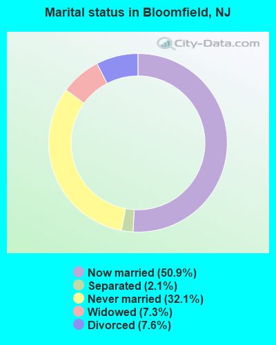
- Never married: 32.1%
- Now married: 50.9%
- Separated: 2.1%
- Widowed: 7.3%
- Divorced: 7.6%
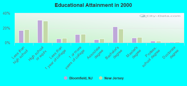
For population 25 years and over in Bloomfield:
- High school or higher: 83.5%
- Bachelor's degree or higher: 31.8%
- Graduate or professional degree: 9.9%
- Unemployed: 5.1%
- Mean travel time to work (commute): 29.4 minutes
| Here: | 12.7 |
| New Jersey average: | 13.1 |
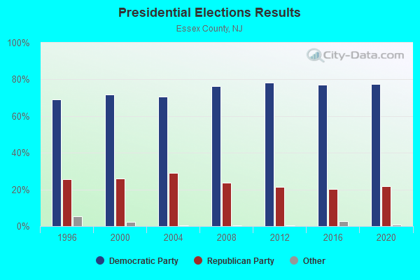
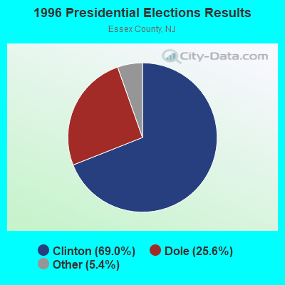

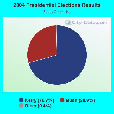
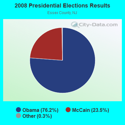
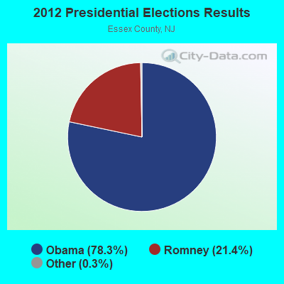
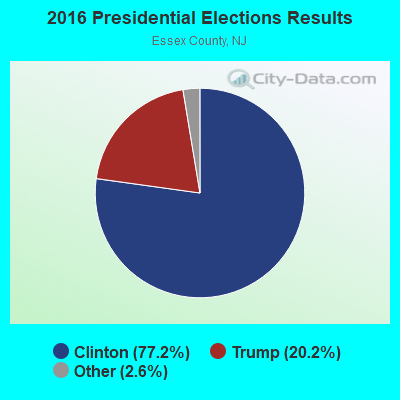
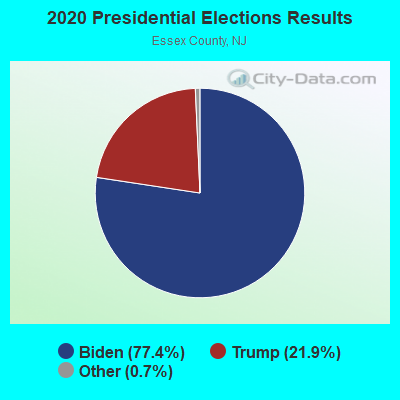
Graphs represent county-level data. Detailed 2008 Election Results
Religion statistics for Bloomfield, NJ (based on Essex County data)
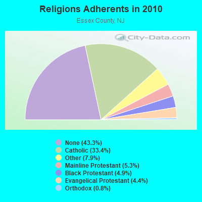
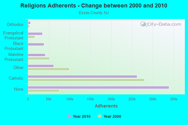
| Religion | Adherents | Congregations |
|---|---|---|
| Catholic | 261,966 | 65 |
| Other | 61,850 | 81 |
| Mainline Protestant | 41,339 | 171 |
| Black Protestant | 38,687 | 88 |
| Evangelical Protestant | 34,666 | 191 |
| Orthodox | 6,188 | 12 |
| None | 339,273 | - |
Food Environment Statistics:
| This county: | 3.95 / 10,000 pop. |
| State: | 2.90 / 10,000 pop. |
| Essex County: | 1.54 / 10,000 pop. |
| New Jersey: | 1.76 / 10,000 pop. |
| Essex County: | 0.39 / 10,000 pop. |
| State: | 0.81 / 10,000 pop. |
| This county: | 6.00 / 10,000 pop. |
| State: | 7.15 / 10,000 pop. |
| Essex County: | 9.4% |
| State: | 8.3% |
| Essex County: | 25.3% |
| New Jersey: | 23.3% |
| Here: | 16.5% |
| New Jersey: | 18.0% |
6.52% of this county's 2021 resident taxpayers lived in other counties in 2020 ($103,528 average adjusted gross income)
| Here: | 6.52% |
| New Jersey average: | 6.70% |
0.01% of residents moved from foreign countries ($16 average AGI)
Essex County: 0.01% New Jersey average: 0.01%
Top counties from which taxpayers relocated into this county between 2020 and 2021:
| from Hudson County, NJ | |
| from Union County, NJ | |
| from Kings County, NY |
7.76% of this county's 2020 resident taxpayers moved to other counties in 2021 ($101,736 average adjusted gross income)
| Here: | 7.76% |
| New Jersey average: | 7.02% |
0.02% of residents moved to foreign countries ($107 average AGI)
Essex County: 0.02% New Jersey average: 0.02%
Top counties to which taxpayers relocated from this county between 2020 and 2021:
| to Union County, NJ | |
| to Morris County, NJ | |
| to Hudson County, NJ |
| Businesses in Bloomfield, NJ | ||||
| Name | Count | Name | Count | |
|---|---|---|---|---|
| 7-Eleven | 2 | Nike | 2 | |
| A&P | 1 | Nissan | 1 | |
| AT&T | 1 | Payless | 2 | |
| Advance Auto Parts | 1 | Quiznos | 1 | |
| BMW | 1 | RadioShack | 1 | |
| CVS | 2 | Rite Aid | 1 | |
| Casual Male XL | 1 | SAS Shoes | 1 | |
| Dunkin Donuts | 5 | Sprint Nextel | 1 | |
| FedEx | 5 | Staples | 1 | |
| GNC | 1 | Stop & Shop | 1 | |
| H&R Block | 1 | Subaru | 1 | |
| Home Depot | 1 | Subway | 1 | |
| Hyundai | 1 | U-Haul | 1 | |
| IHOP | 2 | UPS | 8 | |
| KFC | 1 | Walgreens | 1 | |
| McDonald's | 2 | Wendy's | 1 | |
| New Balance | 1 | |||
Strongest AM radio stations in Bloomfield:
- WOR (710 AM; 50 kW; NEW YORK, NY; Owner: BUCKLEY BROADCASTING CORPORATION)
- WINS (1010 AM; 50 kW; NEW YORK, NY; Owner: INFINITY BROADCASTING OPERATIONS, INC.)
- WMCA (570 AM; 50 kW; NEW YORK, NY; Owner: SALEM MEDIA OF NEW YORK, LLC)
- WEPN (1050 AM; 50 kW; NEW YORK, NY; Owner: NEW YORK AM RADIO, LLC)
- WLIB (1190 AM; 30 kW; NEW YORK, NY; Owner: ICBC BROADCAST HOLDINGS-NY, INC.)
- WADO (1280 AM; 50 kW; NEW YORK, NY; Owner: WADO-AM LICENSE CORP.)
- WABC (770 AM; 50 kW; NEW YORK, NY; Owner: WABC-AM RADIO, INC.)
- WBBR (1130 AM; 50 kW; NEW YORK, NY; Owner: BLOOMBERG COMMUNICATIONS INC.)
- WPAT (930 AM; 5 kW; PATERSON, NJ; Owner: WPAT, INC)
- WNYC (820 AM; 10 kW; NEW YORK, NY; Owner: WNYC RADIO)
- WWRL (1600 AM; 25 kW; NEW YORK, NY; Owner: ACCESS.1 COMMUNICATIONS CORP.-NY)
- WSNR (620 AM; 20 kW; JERSEY CITY, NJ)
- WFAN (660 AM; 50 kW; NEW YORK, NY; Owner: INFINITY BROADCASTING OPERATIONS, INC.)
Strongest FM radio stations in Bloomfield:
- WRKS (98.7 FM; NEW YORK, NY; Owner: EMMIS RADIO LICENSE CORP OF NEW YORK)
- WNEW (102.7 FM; NEW YORK, NY; Owner: INFINITY BROADCASTING OPERATIONS, INC.)
- WFME (94.7 FM; NEWARK, NJ; Owner: FAMILY STATIONS, INC.)
- WMSC (90.3 FM; UPPER MONTCLAIR, NJ; Owner: MONTCLAIR STATE UNIVERSITY)
- WFMU (91.1 FM; EAST ORANGE, NJ; Owner: AURICLE COMMUNICATIONS)
- WNYC-FM (93.9 FM; NEW YORK, NY; Owner: WNYC RADIO)
- WPAT-FM (93.1 FM; PATERSON, NJ; Owner: WPAT LICENSING, INC.)
- WKTU (103.5 FM; LAKE SUCCESS, NY; Owner: AMFM RADIO LICENSES, LLC)
- WQCD (101.9 FM; NEW YORK, NY; Owner: EMMIS RADIO LICENSE CORPORATION)
- WAXQ (104.3 FM; NEW YORK, NY; Owner: AMFM NEW YORK LICENSES, LLC)
- WHTZ (100.3 FM; NEWARK, NJ; Owner: AMFM RADIO LICENSES, L.L.C.)
- WWPR-FM (105.1 FM; NEW YORK, NY; Owner: AMFM RADIO LICENSES, L.L.C.)
- WBGO (88.3 FM; NEWARK, NJ; Owner: NEWARK PUBLIC RADIO INC.)
- WCAA (105.9 FM; NEWARK, NJ; Owner: WADO-AM LICENSE CORP. ("WADO"))
- WCBS-FM (101.1 FM; NEW YORK, NY; Owner: INFINITY BROADCASTING OPERATIONS, INC.)
- WBAI (99.5 FM; NEW YORK, NY; Owner: PACIFICA FOUNDATION, INC.)
- WBLS (107.5 FM; NEW YORK, NY; Owner: ICBC BROADCAST HOLDINGS-NY, INC.)
- WLTW (106.7 FM; NEW YORK, NY; Owner: AMFM NEW YORK LICENSES, LLC)
- WQXR-FM (96.3 FM; NEW YORK, NY; Owner: THE NEW YORK TIMES ELECTRONIC MEDIA COMPANY)
- WSKQ-FM (97.9 FM; NEW YORK, NY; Owner: WSKQ LICENSING, INC.)
TV broadcast stations around Bloomfield:
- WPXO-LP (Channel 34; EAST ORANGE, NJ; Owner: PAXSON COMMUNICATIONS LPTV, INC.)
- WNYW (Channel 5; NEW YORK, NY; Owner: FOX TELEVISION STATIONS, INC.)
- WCBS-TV (Channel 2; NEW YORK, NY; Owner: CBS BROADCASTING INC.)
- WABC-TV (Channel 7; NEW YORK, NY; Owner: AMERICAN BROADCASTING COMPANIES, INC)
- WPIX (Channel 11; NEW YORK, NY; Owner: WPIX, INC.)
- WWOR-TV (Channel 9; SECAUCUS, NJ; Owner: FOX TELEVISION STATIONS, INC.)
- WPXN-TV (Channel 31; NEW YORK, NY; Owner: PAXSON COMMUNICATIONS LICENSE COMPANY, LLC)
- WNJU (Channel 47; LINDEN, NJ; Owner: WNJU LICENSE CORPORATION)
- WNBC (Channel 4; NEW YORK, NY; Owner: NATIONAL BROADCASTING COMPANY, INC.)
- WNET (Channel 13; NEWARK, NJ; Owner: EDUCATIONAL BROADCASTING CORPORATION)
- WXTV (Channel 41; PATERSON, NJ; Owner: WXTV LICENSE PARTNERSHIP, G.P.)
- WFUT (Channel 68; NEWARK, NJ; Owner: UNIVISION NEW YORK LLC)
- WNYE-TV (Channel 25; NEW YORK, NY; Owner: NEW YORK CITY BOARD OF EDUCATION)
- WKOB-LP (Channel 53; NEW YORK, NY; Owner: WKOB COMMUNICATIONS, INC.)
- WEBR-CA (Channel 17; MANHATTAN, NY; Owner: K LICENSEE INC.)
- WRNN-LP (Channel 57; NYACK, NY; Owner: LP NYACK LIMITED PARTNERSHIP)
- WXNY-LP (Channel 32; NEW YORK, NY; Owner: ISLAND BROADCASTING COMPANY)
- W60AI (Channel 60; NEW YORK, NY; Owner: VENTANA TELEVISION, INC.)
- WNXY-LP (Channel 26; NEW YORK, NY; Owner: ISLAND BROADCASTING COMPANY)
- W33BS (Channel 33; DARIEN, CT; Owner: CT&T BROADCASTING, INC.)
- WNYN-LP (Channel 39; NEW YORK, NY; Owner: ISLAND BROADCASTING COMPANY)
- WNYX-LP (Channel 35; NEW YORK, NY; Owner: ISLAND BROADCASTING COMPANY)
- W68DN (Channel 68; CHERRY HILL, ETC., NJ; Owner: MARCIA COHEN)
- WFME-TV (Channel 66; WEST MILFORD, NJ; Owner: FAMILY STATIONS, INC.)
- WLBX-LP (Channel 22; CRANFORD, NJ; Owner: RENARD COMMUNICATIONS CORP.)
- National Bridge Inventory (NBI) Statistics
- 55Number of bridges
- 433ft / 132mTotal length
- $38,065,000Total costs
- 2,784,434Total average daily traffic
- 36,090Total average daily truck traffic
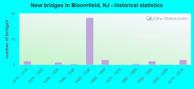
- New bridges - historical statistics
- 31910-1919
- 21930-1939
- 11940-1949
- 371950-1959
- 41960-1969
- 11980-1989
- 31990-1999
- 42010-2019
FCC Registered Broadcast Land Mobile Towers: 34 (See the full list of FCC Registered Broadcast Land Mobile Towers in Bloomfield, NJ)
FCC Registered Microwave Towers: 8 (See the full list of FCC Registered Microwave Towers in this town)
FCC Registered Maritime Coast & Aviation Ground Towers: 1 (See the full list of FCC Registered Maritime Coast & Aviation Ground Towers)
FCC Registered Amateur Radio Licenses: 137 (See the full list of FCC Registered Amateur Radio Licenses in Bloomfield)
FAA Registered Aircraft: 8 (See the full list of FAA Registered Aircraft in Bloomfield)
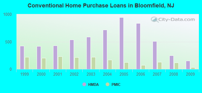
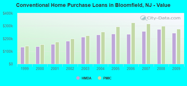
| Home Mortgage Disclosure Act Aggregated Statistics For Year 2009 (Based on 12 full tracts) | ||||||||||||
| A) FHA, FSA/RHS & VA Home Purchase Loans | B) Conventional Home Purchase Loans | C) Refinancings | D) Home Improvement Loans | E) Loans on Dwellings For 5+ Families | F) Non-occupant Loans on < 5 Family Dwellings (A B C & D) | |||||||
|---|---|---|---|---|---|---|---|---|---|---|---|---|
| Number | Average Value | Number | Average Value | Number | Average Value | Number | Average Value | Number | Average Value | Number | Average Value | |
| LOANS ORIGINATED | 158 | $275,147 | 150 | $244,675 | 796 | $251,999 | 34 | $81,646 | 4 | $1,497,500 | 25 | $199,319 |
| APPLICATIONS APPROVED, NOT ACCEPTED | 23 | $295,867 | 22 | $256,995 | 75 | $243,289 | 9 | $35,444 | 1 | $333,000 | 4 | $171,495 |
| APPLICATIONS DENIED | 39 | $265,717 | 28 | $241,210 | 390 | $269,402 | 50 | $61,860 | 1 | $1,350,000 | 13 | $169,846 |
| APPLICATIONS WITHDRAWN | 22 | $280,588 | 14 | $258,711 | 218 | $272,616 | 6 | $219,167 | 0 | $0 | 15 | $262,467 |
| FILES CLOSED FOR INCOMPLETENESS | 11 | $280,000 | 8 | $269,740 | 71 | $273,489 | 2 | $85,000 | 0 | $0 | 4 | $286,250 |
Detailed mortgage data for all 12 tracts in Bloomfield, NJ
| Private Mortgage Insurance Companies Aggregated Statistics For Year 2009 (Based on 12 full tracts) | ||||||
| A) Conventional Home Purchase Loans | B) Refinancings | C) Non-occupant Loans on < 5 Family Dwellings (A & B) | ||||
|---|---|---|---|---|---|---|
| Number | Average Value | Number | Average Value | Number | Average Value | |
| LOANS ORIGINATED | 34 | $275,936 | 19 | $326,939 | 0 | $0 |
| APPLICATIONS APPROVED, NOT ACCEPTED | 12 | $286,167 | 15 | $313,323 | 0 | $0 |
| APPLICATIONS DENIED | 6 | $321,162 | 3 | $357,323 | 0 | $0 |
| APPLICATIONS WITHDRAWN | 3 | $296,667 | 3 | $345,667 | 0 | $0 |
| FILES CLOSED FOR INCOMPLETENESS | 3 | $270,333 | 2 | $323,500 | 1 | $361,000 |
2003 - 2018 National Fire Incident Reporting System (NFIRS) incidents
- Fire incident types reported to NFIRS in Bloomfield, NJ
- 1,45962.6%Structure Fires
- 47020.2%Outside Fires
- 34214.7%Mobile Property/Vehicle Fires
- 592.5%Other
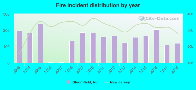 According to the data from the years 2003 - 2018 the average number of fires per year is 146. The highest number of reported fires - 240 took place in 2005, and the least - 2 in 2006. The data has a declining trend.
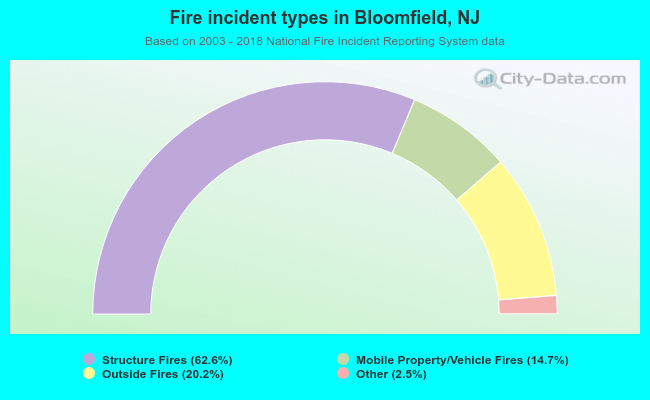 When looking into fire subcategories, the most incidents belonged to: Structure Fires (62.6%), and Outside Fires (20.2%).
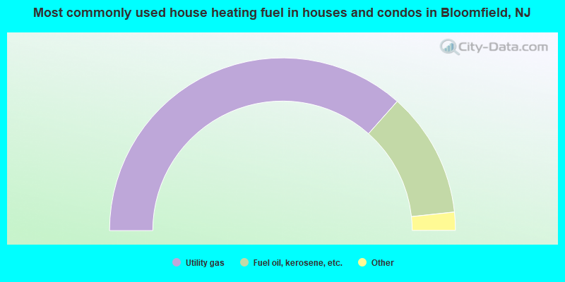
- 73.1%Utility gas
- 23.5%Fuel oil, kerosene, etc.
- 2.1%Electricity
- 1.2%Bottled, tank, or LP gas
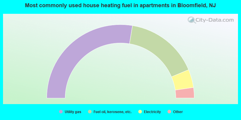
- 55.2%Utility gas
- 32.2%Fuel oil, kerosene, etc.
- 8.0%Electricity
- 3.2%Bottled, tank, or LP gas
- 0.7%No fuel used
- 0.5%Other fuel
- 0.1%Coal or coke
- 0.1%Wood
Bloomfield compared to New Jersey state average:
- Unemployed percentage significantly below state average.
- Median age below state average.
- Renting percentage significantly below state average.
- Length of stay since moving in significantly above state average.
- Number of rooms per house significantly below state average.
- House age significantly below state average.
- Institutionalized population percentage significantly above state average.
Bloomfield on our top lists:
- #34 on the list of "Top 101 cities with largest percentage of females in industries: chemicals (population 5,000+)"
- #69 on the list of "Top 101 cities with the most residents born in Guyana (population 500+)"
- #85 on the list of "Top 101 cities with largest percentage of females in occupations: plant and system operators (population 5,000+)"
- #93 on the list of "Top 101 cities with largest percentage of males in industries: publishing, and motion picture and sound recording industries (population 5,000+)"
- #7 on the list of "Top 101 counties with the highest Nitrogen Dioxide air pollution readings in 2012 (ppm)"
- #9 on the list of "Top 101 counties with the lowest percentage of residents that keep firearms around their homes"
- #19 on the list of "Top 101 counties with the most Black Protestant adherents"
- #20 on the list of "Top 101 counties with highest percentage of residents voting for Obama (Democrat) in the 2012 Presidential Election (pop. 50,000+)"
- #23 on the list of "Top 101 counties with the most Black Protestant congregations (pop. 50,000+)"

|
|
Total of 245 patent applications in 2008-2024.