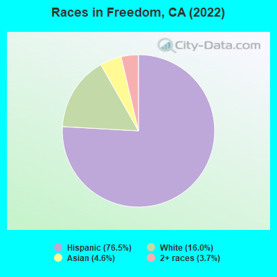
Percentage of residents living in poverty in 2022: 7.0%
(10.4% for White Non-Hispanic residents, 6.5% for Hispanic or Latino residents, 9.6% for other race residents, 2.5% for two or more races residents)
Latest news from Freedom, CA collected exclusively by city-data.com from local newspapers, TV, and radio stations
Ancestries: Yugoslavian (2.1%), Italian (1.7%), Syrian (1.3%), European (1.1%), Croatian (1.0%).
Current Local Time: PST time zone
Elevation: 120 feet
Land area: 1.34 square miles.
Population density: 2,292 people per square mile (low).
879 residents are foreign born (24.1% Latin America).
This place:
26.6%
California:
26.5%
Median real estate property taxes paid for housing units with mortgages in 2022: $3,322 (0.5%) Median real estate property taxes paid for housing units with no mortgage in 2022: $1,963 (0.3%)
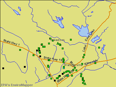
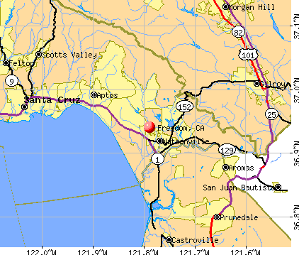
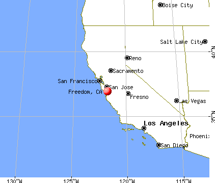
Nearest city with pop. 50,000+: Santa Cruz, CA (13.3 miles , pop. 54,593).
Nearest city with pop. 200,000+: San Jose, CA (25.6 miles , pop. 894,943).
Nearest city with pop. 1,000,000+: Los Angeles, CA (275.5 miles , pop. 3,694,820).
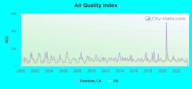
Air Quality Index (AQI) level in 2023 was 57.3. This is better than average.
City:
57.3
U.S.:
72.6
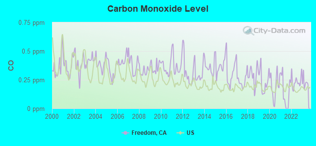
Carbon Monoxide (CO) [ppm] level in 2023 was 0.228. This is about average.Closest monitor was 12.5 miles away from the city center.
City:
0.228
U.S.:
0.251
Nitrogen Dioxide (NO2) [ppb] level in 2023 was 2.40. This is significantly better than average.Closest monitor was 8.3 miles away from the city center.
City:
2.40
U.S.:
5.11
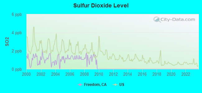
Sulfur Dioxide (SO2) [ppb] level in 2009 was 1.22. This is better than average.Closest monitor was 18.9 miles away from the city center.
City:
1.22
U.S.:
1.51
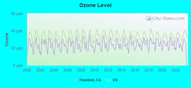
Ozone [ppb] level in 2023 was 26.5. This is better than average.Closest monitor was 0.6 miles away from the city center.
City:
26.5
U.S.:
33.3
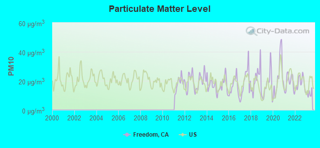
Particulate Matter (PM10) [µg/m3] level in 2023 was 11.6. This is significantly better than average.Closest monitor was 0.6 miles away from the city center.
City:
11.6
U.S.:
19.2
Particulate Matter (PM2.5) [µg/m3] level in 2023 was 4.98. This is significantly better than average.Closest monitor was 11.4 miles away from the city center.
City:
4.98
U.S.:
8.11
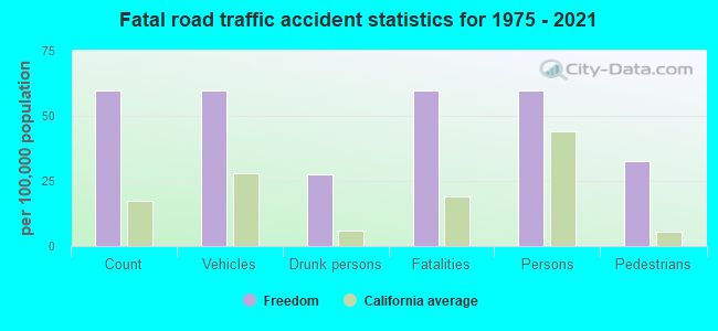
Earthquake activity:
Freedom-area historical earthquake activity is significantly above California state average. It is 7617% greater than the overall U.S. average.
On 4/18/1906 at 13:12:21, a magnitude 7.9 (7.9 UK, Class: Major, Intensity: VIII - XII) earthquake occurred 98.9 miles away from the city center, causing $524,000,000 total damage On 10/18/1989 at 00:04:15, a magnitude 7.1 (6.5 MB, 7.1 MS, 6.9 MW, 7.0 ML) earthquake occurred 11.8 miles away from the city center, causing 62 deaths (62 shaking deaths) and 3757 injuries, causing $1,305,032,704 total damage On 11/4/1927 at 13:51:53, a magnitude 7.5 (7.5 UK) earthquake occurred 146.4 miles away from the city center On 7/21/1952 at 11:52:14, a magnitude 7.7 (7.7 UK) earthquake occurred 205.9 miles away from Freedom center, causing $50,000,000 total damage On 5/2/1983 at 23:42:37, a magnitude 6.7 (6.2 MB, 6.5 MS, 6.5 MW, 6.7 ML, Class: Strong, Intensity: VII - IX) earthquake occurred 96.5 miles away from Freedom center, causing $31,000,000 total damage On 12/21/1932 at 06:10:09, a magnitude 7.2 (7.2 UK) earthquake occurred 229.9 miles away from Freedom center Magnitude types: body-wave magnitude (MB), local magnitude (ML), surface-wave magnitude (MS), moment magnitude (MW)
Natural disasters:
The number of natural disasters in Santa Cruz County (27) is a lot greater than the US average (15). Major Disasters (Presidential) Declared: 14 Emergencies Declared: 3
Causes of natural disasters: Floods: 13, Fires: 8, Mudslides: 7, Storms: 7, Winter Storms: 6, Landslides: 4, Drought: 1, Earthquake: 1, Freeze: 1, Hurricane: 1, Tornado: 1, Tsunami Wave: 1, Other: 1 (Note: some incidents may be assigned to more than one category).
Hospitals and medical centers near Freedom:
SATELLITE DIALYSIS (Dialysis Facility, about 1 miles away; WATSONVILLE, CA)
WATSONVILLE COMMUNITY HOSPITAL D/P SNF (Nursing Home, about 2 miles away; WATSONVILLE, CA)
COUNTRY VILLA WATSONVILLE WEST NRSG AND REHAB CENTER (Nursing Home, about 2 miles away; WATSONVILLE, CA)
VALLEY CONVALESCENT HOSPITAL (Nursing Home, about 3 miles away; WATSONVILLE, CA)
GOLDEN AGE CONVALESCENT HOSPITAL (Nursing Home, about 10 miles away; CAPITOLA, CA)
PACIFIC COAST MANOR (Nursing Home, about 10 miles away; CAPITOLA, CA)
CAPITOLA CARE CENTER (Nursing Home, about 11 miles away; SANTA CRUZ, CA)
Amtrak stations near Freedom:
3 miles: WATSONVILLE (W. LAKE AVE. & RODRIGUEZ ST.) - Bus Station . Services: fully wheelchair accessible, public payphones, snack bar, free short-term parking, taxi stand, public transit connection.
14 miles: GILROY (7250 MONTEREY HWY.) - Bus Station . Services: partially wheelchair accessible, public payphones, free short-term parking, free long-term parking, public transit connection.
14 miles: SANTA CRUZ (920 PACIFIC AVE.) - Bus Station . Services: fully wheelchair accessible, public payphones, snack bar, public transit connection.
Colleges/universities with over 2000 students nearest to Freedom:
Cabrillo College (about 9 miles; Aptos, CA; Full-time enrollment: 7,729)
Gavilan College (about 13 miles; Gilroy, CA; FT enrollment: 3,327)
University of California-Santa Cruz (about 16 miles; Santa Cruz, CA; FT enrollment: 17,751)
Hartnell College (about 20 miles; Salinas, CA; FT enrollment: 5,506)
California State University-Monterey Bay (about 20 miles; Seaside, CA; FT enrollment: 5,125)
Naval Postgraduate School (about 25 miles; Monterey, CA; FT enrollment: 4,951)
Monterey Peninsula College (about 25 miles; Monterey, CA; FT enrollment: 4,588)
Santa Cruz County has a predicted average indoor radon screening level between 2 and 4 pCi/L (pico curies per liter) - Moderate Potential
Average household size:
This place:
4.0 people
California:
2.9 people
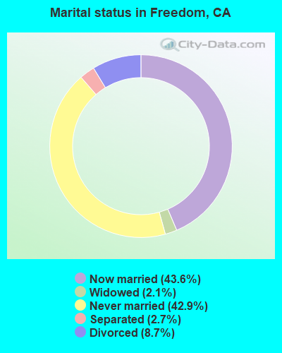
Percentage of family households:
This place:
82.7%
Whole state:
68.7%
Percentage of households with unmarried partners:
This place:
9.5%
Whole state:
7.2%
Likely homosexual households (counted as self-reported same-sex unmarried-partner households)
Lesbian couples: 1.2% of all households
Gay men: 0.3% of all households
6 people in group homes for juveniles (non-correctional) in 2010
7 people in other noninstitutional group quarters in 2000
5 people in other nonhousehold living situations in 2000
Banks with branches in Freedom (2011 data):
U.S. Bank National Association: Watsonville Safeway at 2010 Freedom Boulevard, branch established on 2007/04/27. Info updated 2012/01/30: Bank assets: $330,470.8 mil, Deposits: $236,091.5 mil, headquarters in Cincinnati, OH, positive income, 3121 total offices, Holding Company: U.S. Bancorp
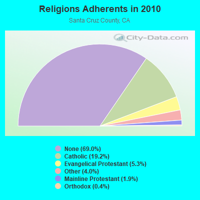
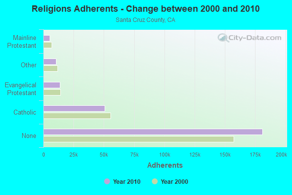
Religion statistics for Freedom, CA (based on Santa Cruz County data)
Religion
Adherents
Congregations
Catholic
50,500
13
Evangelical Protestant
13,838
84
Other
10,593
52
Mainline Protestant
5,049
28
Orthodox
1,104
4
Black Protestant
238
3
None
181,060
-
Source: Clifford Grammich, Kirk Hadaway, Richard Houseal, Dale E.Jones, Alexei Krindatch, Richie Stanley and Richard H.Taylor. 2012. 2010 U.S.Religion Census: Religious Congregations & Membership Study. Association of Statisticians of American Religious Bodies. Jones, Dale E., et al. 2002. Congregations and Membership in the United States 2000. Nashville, TN: Glenmary Research Center. Graphs represent county-level data
Aircraft: CESSNA 150G (Category: Land, Seats: 2, Weight: Up to 12,499 Pounds, Speed: 90 mph), Engine: CONT MOTOR 0-200 SERIES (100 HP) (4 Cycle) N-Number: 2758S, N2758S, N-2758S, Serial Number: 15066658, Year manufactured: 1967, Airworthiness Date: 05/08/1967, Certificate Issue Date: 10/30/2007 Registrant (Partnership): Sarah M Chauvet, 2106 Freedom Blvd, Freedom, CA 95019, Other Owners: Edward Ralph Bogner
Aircraft: GRUMMAN ACFT ENG COR-SCHWEIZER G-164A (Category: Land, Weight: Up to 12,499 Pounds, Speed: 81 mph), Engine: P&W R-985 SERIES (450 HP) (Reciprocating) N-Number: 5472, N5472, N-5472, Serial Number: 1170, Airworthiness Date: 11/20/1973, Certificate Issue Date: 12/13/2019 Registrant (Corporation): South Coast Service, Po Box 1011, Freedom, CA 95019
Aircraft: CESSNA 175A (Category: Land, Seats: 4, Weight: Up to 12,499 Pounds, Speed: 105 mph), Engine: CONT MOTOR GO-300 SERIES (175 HP) (Reciprocating) N-Number: 7974T, N7974T, N-7974T, Serial Number: 56674, Year manufactured: 1960, Airworthiness Date: 04/07/1960, Certificate Issue Date: 02/01/2005 Registrant (Co-Owned): Theresa L Byers, Po Box 924, Freedom, CA 95019, Other Owners: George R Byers
Aircraft: BEECH V35B (Category: Land, Seats: 6, Weight: Up to 12,499 Pounds, Speed: 150 mph), Engine: CONT MOTOR IO-550 SERIES (300 HP) (Reciprocating) N-Number: 703FR, N703FR, N-703FR, Serial Number: D-9467, Year manufactured: 1973, Airworthiness Date: 07/01/1992, Certificate Issue Date: 05/22/2000 Registrant (Co-Owned): Paul R Faurot, Po Box 827, Freedom, CA 95019, Other Owners: Rodgers W Faurot Deregistered:Cancel Date: 03/28/2018
Aircraft: STINSON 108-3 (Category: Land, Seats: 4, Weight: Up to 12,499 Pounds, Speed: 94 mph), Engine: FRANKLIN 6A4165 SERIES (165 HP) (Reciprocating) N-Number: 825C, N825C, N-825C, Serial Number: 108-3825, Year manufactured: 1947, Airworthiness Date: 10/02/1956, Certificate Issue Date: 01/26/2012 Registrant (Individual): Richard G Crawford, Po Box 3351, Freedom, CA 95019
Aircraft: RYAN NAVION (Category: Land, Seats: 5, Weight: Up to 12,499 Pounds, Speed: 126 mph), Engine: CONT MOTOR E225 SERIES (225 HP) (Reciprocating) N-Number: 91403, N91403, N-91403, Serial Number: NAV-4-76, Year manufactured: 1946, Airworthiness Date: 01/12/1956 Registrant (Individual): Reported Sale, Po Box 1011, Freedom, CA 95019 Deregistered:Cancel Date: 04/26/2018
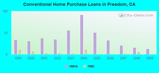
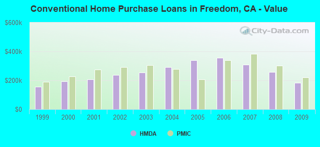
Home Mortgage Disclosure Act Aggregated Statistics For Year 2009 (Based on 2 partial tracts)
A) FHA, FSA/RHS & VA Home Purchase Loans
B) Conventional Home Purchase Loans
C) Refinancings
D) Home Improvement Loans
F) Non-occupant Loans on < 5 Family Dwellings (A B C & D)
G) Loans On Manufactured Home Dwelling (A B C & D)
Number
Average Value
Number
Average Value
Number
Average Value
Number
Average Value
Number
Average Value
Number
Average Value
LOANS ORIGINATED
15
$246,830
13
$184,465
20
$231,363
1
$126,300
6
$185,163
1
$237,890
APPLICATIONS APPROVED, NOT ACCEPTED
1
$374,800
2
$257,905
3
$293,760
0
$0
0
$0
0
$0
APPLICATIONS DENIED
3
$283,813
7
$252,829
14
$281,262
0
$0
3
$187,610
1
$230,790
APPLICATIONS WITHDRAWN
3
$356,180
3
$138,117
6
$248,787
0
$0
1
$146,850
1
$154,720
FILES CLOSED FOR INCOMPLETENESS
1
$168,560
0
$0
1
$402,360
0
$0
0
$0
0
$0
Aggregated Statistics For Year 2008 (Based on 2 partial tracts)
A) FHA, FSA/RHS & VA Home Purchase Loans
B) Conventional Home Purchase Loans
C) Refinancings
D) Home Improvement Loans
F) Non-occupant Loans on < 5 Family Dwellings (A B C & D)
G) Loans On Manufactured Home Dwelling (A B C & D)
Number
Average Value
Number
Average Value
Number
Average Value
Number
Average Value
Number
Average Value
Number
Average Value
LOANS ORIGINATED
9
$346,120
16
$258,992
17
$282,022
2
$198,925
4
$256,658
2
$119,030
APPLICATIONS APPROVED, NOT ACCEPTED
1
$146,290
3
$265,070
3
$295,880
1
$125,910
0
$0
1
$142,240
APPLICATIONS DENIED
1
$428,140
9
$231,142
17
$365,775
1
$99,370
4
$253,928
1
$178,290
APPLICATIONS WITHDRAWN
1
$430,050
4
$377,602
3
$348,023
1
$7,570
0
$0
0
$0
FILES CLOSED FOR INCOMPLETENESS
0
$0
1
$198,520
2
$436,960
0
$0
0
$0
0
$0
Aggregated Statistics For Year 2007 (Based on 2 partial tracts)
B) Conventional Home Purchase Loans
C) Refinancings
D) Home Improvement Loans
F) Non-occupant Loans on < 5 Family Dwellings (A B C & D)
G) Loans On Manufactured Home Dwelling (A B C & D)
Number
Average Value
Number
Average Value
Number
Average Value
Number
Average Value
Number
Average Value
LOANS ORIGINATED
21
$310,088
53
$372,685
6
$293,540
9
$398,248
4
$116,875
APPLICATIONS APPROVED, NOT ACCEPTED
5
$254,210
24
$334,678
2
$300,120
4
$336,388
1
$189,450
APPLICATIONS DENIED
11
$335,057
40
$450,116
5
$348,658
5
$446,990
4
$208,590
APPLICATIONS WITHDRAWN
3
$371,843
18
$440,596
1
$289,460
3
$485,557
0
$0
FILES CLOSED FOR INCOMPLETENESS
2
$351,025
6
$454,578
1
$83,540
1
$315,750
0
$0
Aggregated Statistics For Year 2006 (Based on 2 partial tracts)
B) Conventional Home Purchase Loans
C) Refinancings
D) Home Improvement Loans
F) Non-occupant Loans on < 5 Family Dwellings (A B C & D)
G) Loans On Manufactured Home Dwelling (A B C & D)
Number
Average Value
Number
Average Value
Number
Average Value
Number
Average Value
Number
Average Value
LOANS ORIGINATED
33
$356,626
93
$398,001
14
$312,171
10
$402,520
4
$115,652
APPLICATIONS APPROVED, NOT ACCEPTED
5
$387,162
22
$406,225
1
$129,280
2
$459,735
0
$0
APPLICATIONS DENIED
18
$354,952
53
$423,032
8
$372,248
8
$384,389
1
$60,360
APPLICATIONS WITHDRAWN
7
$368,379
24
$412,048
4
$378,625
3
$441,897
1
$37,890
FILES CLOSED FOR INCOMPLETENESS
2
$338,385
12
$413,589
0
$0
0
$0
0
$0
Aggregated Statistics For Year 2005 (Based on 2 partial tracts)
B) Conventional Home Purchase Loans
C) Refinancings
D) Home Improvement Loans
F) Non-occupant Loans on < 5 Family Dwellings (A B C & D)
G) Loans On Manufactured Home Dwelling (A B C & D)
Number
Average Value
Number
Average Value
Number
Average Value
Number
Average Value
Number
Average Value
LOANS ORIGINATED
51
$337,436
115
$387,639
11
$303,777
13
$380,602
4
$104,665
APPLICATIONS APPROVED, NOT ACCEPTED
10
$303,217
17
$414,486
4
$255,695
3
$336,843
0
$0
APPLICATIONS DENIED
21
$323,344
56
$391,443
8
$207,642
6
$314,028
2
$322,730
APPLICATIONS WITHDRAWN
7
$409,430
27
$344,647
3
$236,420
6
$355,425
0
$0
FILES CLOSED FOR INCOMPLETENESS
4
$295,760
7
$455,373
1
$101,570
0
$0
0
$0
Aggregated Statistics For Year 2004 (Based on 2 partial tracts)
B) Conventional Home Purchase Loans
C) Refinancings
D) Home Improvement Loans
F) Non-occupant Loans on < 5 Family Dwellings (A B C & D)
G) Loans On Manufactured Home Dwelling (A B C & D)
Number
Average Value
Number
Average Value
Number
Average Value
Number
Average Value
Number
Average Value
LOANS ORIGINATED
92
$292,008
96
$281,426
9
$210,893
13
$269,668
4
$101,798
APPLICATIONS APPROVED, NOT ACCEPTED
16
$332,941
15
$340,133
0
$0
1
$210,290
1
$51,360
APPLICATIONS DENIED
18
$331,581
29
$319,891
5
$112,728
3
$262,467
1
$124,380
APPLICATIONS WITHDRAWN
9
$299,074
21
$284,542
2
$122,235
2
$259,090
1
$39,360
FILES CLOSED FOR INCOMPLETENESS
4
$243,900
9
$322,890
1
$12,630
0
$0
0
$0
Aggregated Statistics For Year 2003 (Based on 2 partial tracts)
B) Conventional Home Purchase Loans
C) Refinancings
D) Home Improvement Loans
F) Non-occupant Loans on < 5 Family Dwellings (A B C & D)
Number
Average Value
Number
Average Value
Number
Average Value
Number
Average Value
LOANS ORIGINATED
56
$252,720
182
$226,703
2
$51,075
19
$238,789
APPLICATIONS APPROVED, NOT ACCEPTED
6
$295,942
23
$244,787
1
$41,300
3
$331,330
APPLICATIONS DENIED
11
$221,750
31
$234,134
6
$57,693
3
$233,250
APPLICATIONS WITHDRAWN
6
$306,093
27
$219,936
0
$0
2
$287,275
FILES CLOSED FOR INCOMPLETENESS
1
$140,670
5
$224,276
1
$53,680
1
$43,570
Aggregated Statistics For Year 2002 (Based on 2 partial tracts)
B) Conventional Home Purchase Loans
C) Refinancings
D) Home Improvement Loans
F) Non-occupant Loans on < 5 Family Dwellings (A B C & D)
Number
Average Value
Number
Average Value
Number
Average Value
Number
Average Value
LOANS ORIGINATED
35
$237,756
104
$211,982
3
$23,197
10
$215,865
APPLICATIONS APPROVED, NOT ACCEPTED
1
$181,240
21
$201,090
0
$0
3
$178,243
APPLICATIONS DENIED
5
$250,862
34
$239,894
2
$38,055
2
$293,625
APPLICATIONS WITHDRAWN
4
$243,355
17
$209,534
2
$52,590
1
$51,780
FILES CLOSED FOR INCOMPLETENESS
0
$0
7
$239,983
0
$0
0
$0
Aggregated Statistics For Year 2001 (Based on 2 partial tracts)
B) Conventional Home Purchase Loans
C) Refinancings
D) Home Improvement Loans
F) Non-occupant Loans on < 5 Family Dwellings (A B C & D)
Number
Average Value
Number
Average Value
Number
Average Value
Number
Average Value
LOANS ORIGINATED
38
$208,061
111
$200,920
8
$37,868
14
$195,223
APPLICATIONS APPROVED, NOT ACCEPTED
4
$193,905
11
$201,933
1
$63,680
1
$120,450
APPLICATIONS DENIED
6
$193,923
30
$170,623
5
$16,482
5
$220,852
APPLICATIONS WITHDRAWN
8
$200,208
26
$201,062
2
$44,405
2
$230,700
FILES CLOSED FOR INCOMPLETENESS
2
$53,505
7
$201,684
0
$0
0
$0
Aggregated Statistics For Year 2000 (Based on 2 partial tracts)
B) Conventional Home Purchase Loans
C) Refinancings
D) Home Improvement Loans
F) Non-occupant Loans on < 5 Family Dwellings (A B C & D)
Number
Average Value
Number
Average Value
Number
Average Value
Number
Average Value
LOANS ORIGINATED
31
$192,288
36
$162,142
5
$22,968
5
$161,744
APPLICATIONS APPROVED, NOT ACCEPTED
6
$125,550
8
$166,881
1
$23,080
0
$0
APPLICATIONS DENIED
10
$144,929
24
$159,578
2
$44,900
1
$220,390
APPLICATIONS WITHDRAWN
4
$177,335
11
$140,263
0
$0
1
$157,460
FILES CLOSED FOR INCOMPLETENESS
1
$310,770
15
$162,313
1
$28,420
0
$0
Aggregated Statistics For Year 1999 (Based on 2 partial tracts)
A) FHA, FSA/RHS & VA Home Purchase Loans
B) Conventional Home Purchase Loans
C) Refinancings
D) Home Improvement Loans
F) Non-occupant Loans on < 5 Family Dwellings (A B C & D)
#76 on the list of "Top 100 cities with declining populations from 2000 to 2014"
#2 on the list of "Top 101 counties with the lowest number of infant deaths per 1000 residents 2007-2013 (pop. 50,000+)"
#6 on the list of "Top 101 counties with the largest decrease in the number of infant deaths per 1000 residents 2000-2006 to 2007-2013 (pop. 50,000+)"
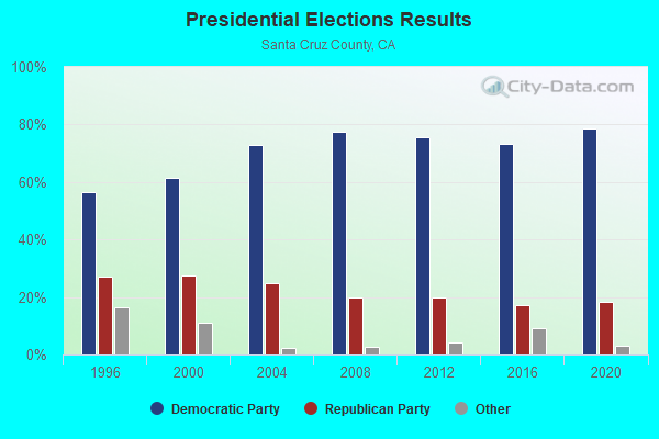
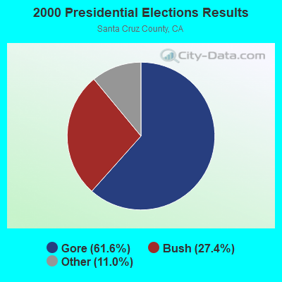
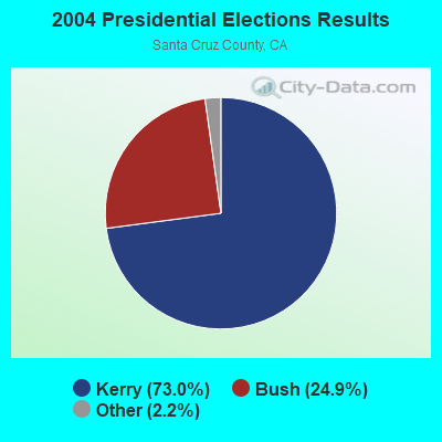
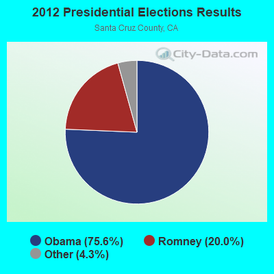
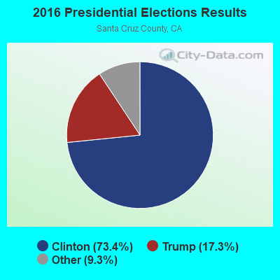
#9 on the list of "Top 101 counties with highest percentage of residents voting for 3rd party candidates in the 2012 Presidential Election (pop. 50,000+)"
#24 on the list of "Top 101 counties with the lowest Ozone (1-hour) air pollution readings in 2012 (ppm)"
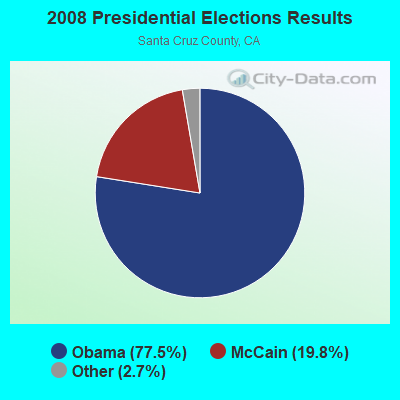
#27 on the list of "Top 101 counties with highest percentage of residents voting for Obama (Democrat) in the 2012 Presidential Election (pop. 50,000+)"


 Recent articles from our blog. Our writers, many of them Ph.D. graduates or candidates, create easy-to-read articles on a wide variety of topics.


 (13.3 miles