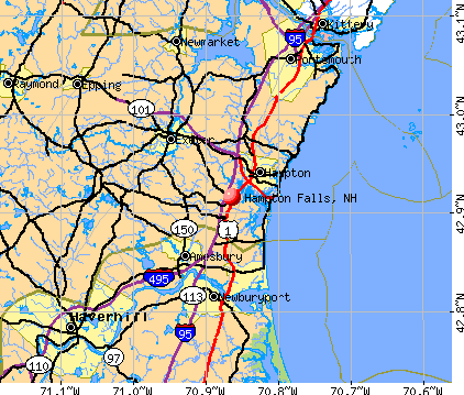
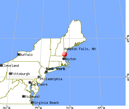
Hampton Falls, New Hampshire
Submit your own pictures of this town and show them to the world
- OSM Map
- General Map
- Google Map
- MSN Map
Population change since 2000: +18.9%
 |
| Males: 1,122 | |
| Females: 1,114 |
| Median resident age: | 45.2 years |
| New Hampshire median age: | 43.9 years |
Zip codes: 03844.
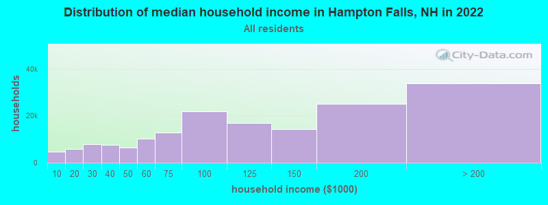
| Hampton Falls: | $141,066 |
| NH: | $89,992 |
Estimated per capita income in 2022: $76,961 (it was $35,060 in 2000)
Hampton Falls town income, earnings, and wages data
Estimated median house or condo value in 2022: $832,037 (it was $272,300 in 2000)
| Hampton Falls: | $832,037 |
| NH: | $384,700 |
Mean prices in 2022: all housing units: $614,227; detached houses: $665,470; townhouses or other attached units: $408,866; in 2-unit structures: $730,084; in 3-to-4-unit structures: over $1,000,000; in 5-or-more-unit structures: $329,099; mobile homes: $126,160
Detailed information about poverty and poor residents in Hampton Falls, NH


- 2,18197.5%White alone
- 170.8%Asian alone
- 170.8%Two or more races
- 140.6%Hispanic
- 50.2%Black alone
- 10.04%American Indian alone
- 10.04%Other race alone
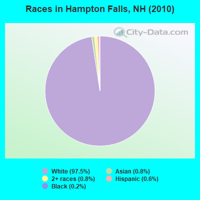
Races in Hampton Falls detailed stats: ancestries, foreign born residents, place of birth
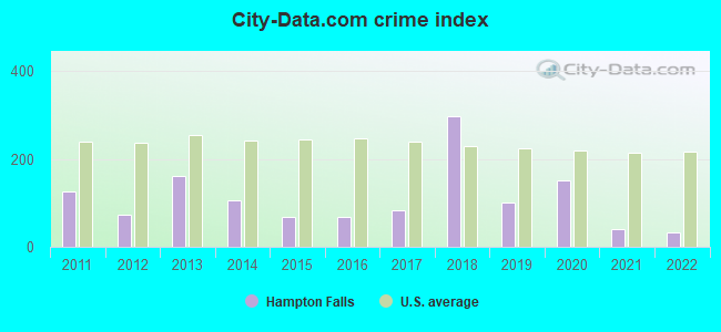
Type |
2011 |
2012 |
2013 |
2014 |
2015 |
2016 |
2017 |
2018 |
2019 |
2020 |
2021 |
2022 |
|---|---|---|---|---|---|---|---|---|---|---|---|---|
| Murders (per 100,000) | 0 (0.0) | 0 (0.0) | 0 (0.0) | 0 (0.0) | 0 (0.0) | 0 (0.0) | 0 (0.0) | 0 (0.0) | 0 (0.0) | 0 (0.0) | 0 (0.0) | 0 (0.0) |
| Rapes (per 100,000) | 0 (0.0) | 0 (0.0) | 1 (43.6) | 1 (43.3) | 0 (0.0) | 0 (0.0) | 1 (43.4) | 7 (294.1) | 2 (83.9) | 3 (123.1) | 0 (0.0) | 0 (0.0) |
| Robberies (per 100,000) | 1 (44.7) | 0 (0.0) | 2 (87.2) | 0 (0.0) | 0 (0.0) | 0 (0.0) | 0 (0.0) | 0 (0.0) | 0 (0.0) | 0 (0.0) | 1 (40.7) | 0 (0.0) |
| Assaults (per 100,000) | 2 (89.3) | 0 (0.0) | 3 (130.8) | 1 (43.3) | 4 (172.9) | 1 (43.4) | 1 (43.4) | 2 (84.0) | 0 (0.0) | 2 (82.1) | 1 (40.7) | 1 (41.5) |
| Burglaries (per 100,000) | 12 (536.0) | 12 (534.3) | 12 (523.1) | 7 (303.3) | 3 (129.6) | 6 (260.5) | 4 (173.8) | 4 (168.1) | 2 (83.9) | 1 (41.0) | 0 (0.0) | 1 (41.5) |
| Thefts (per 100,000) | 28 (1,251) | 20 (890.5) | 19 (828.2) | 22 (953.2) | 14 (605.0) | 17 (738.2) | 15 (651.6) | 16 (672.3) | 17 (712.8) | 16 (656.5) | 13 (528.7) | 11 (456.8) |
| Auto thefts (per 100,000) | 2 (89.3) | 0 (0.0) | 1 (43.6) | 1 (43.3) | 0 (0.0) | 3 (130.3) | 0 (0.0) | 2 (84.0) | 0 (0.0) | 2 (82.1) | 0 (0.0) | 1 (41.5) |
| Arson (per 100,000) | 0 (0.0) | 0 (0.0) | 0 (0.0) | 0 (0.0) | 0 (0.0) | 0 (0.0) | 1 (43.4) | 0 (0.0) | 0 (0.0) | 1 (41.0) | 0 (0.0) | 0 (0.0) |
| City-Data.com crime index | 125.9 | 73.0 | 160.4 | 106.2 | 67.8 | 66.9 | 81.7 | 297.5 | 101.5 | 150.6 | 41.5 | 32.8 |
The City-Data.com crime index weighs serious crimes and violent crimes more heavily. Higher means more crime, U.S. average is 246.1. It adjusts for the number of visitors and daily workers commuting into cities.
Crime rate in Hampton Falls detailed stats: murders, rapes, robberies, assaults, burglaries, thefts, arson
Full-time law enforcement employees in 2021, including police officers: 5 (5 officers - 5 male; 0 female).
| Officers per 1,000 residents here: | 2.03 |
| New Hampshire average: | 2.14 |
 Recent articles from our blog. Our writers, many of them Ph.D. graduates or candidates, create easy-to-read articles on a wide variety of topics.


 | Move to NH - Suggested Areas & Towns? (108 replies) |
| Planning a trip to NH (2 replies) |
| Moving to southeast NH, looking for suggestions (22 replies) |
| Apple pickin' time! (1 reply) |
| New Hampshire Farm Stands or Farm Stores (9 replies) |
| Tiny house living - legally difficult in New Hampshire (12 replies) |
Latest news from Hampton Falls, NH collected exclusively by city-data.com from local newspapers, TV, and radio stations
Ancestries: Irish (24.5%), English (23.6%), German (12.3%), Italian (10.5%), French (10.0%), Scottish (5.8%).
Current Local Time: EST time zone
Incorporated in 1726
Elevation: 40 feet
Land area: 12.2 square miles.
Population density: 183 people per square mile (very low).
46 residents are foreign born (0.9% Asia, 0.7% Europe, 0.5% North America, 0.3% Latin America).
| This town: | 2.4% |
| New Hampshire: | 4.4% |
| Hampton Falls town: | 1.6% ($4,336) |
| New Hampshire: | 2.3% ($2,946) |
Nearest city with pop. 50,000+: Haverhill, MA  (14.2 miles , pop. 58,969).
Nearest city with pop. 200,000+: Boston, MA (42.9 miles , pop. 589,141).
Nearest city with pop. 1,000,000+: Bronx, NY (210.4 miles , pop. 1,332,650).
Nearest cities:
), ), ), ), ), Latitude: 42.92 N, Longitude: 70.89 W
Area code commonly used in this area: 603

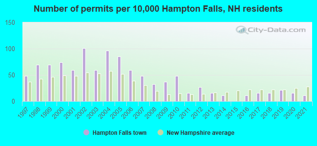
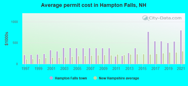
Single-family new house construction building permits:
- 2021: 2 buildings, average cost: $800,000
- 2020: 3 buildings, average cost: $532,900
- 2019: 4 buildings, average cost: $498,800
- 2018: 3 buildings, average cost: $544,800
- 2017: 3 buildings, average cost: $544,800
- 2016: 2 buildings, average cost: $762,500
- 2014: 2 buildings, average cost: $380,000
- 2013: 3 buildings, average cost: $265,700
- 2012: 5 buildings, average cost: $197,000
- 2011: 3 buildings, average cost: $183,300
- 2010: 9 buildings, average cost: $380,200
- 2009: 7 buildings, average cost: $380,200
- 2008: 6 buildings, average cost: $380,200
- 2007: 9 buildings, average cost: $380,100
- 2006: 11 buildings, average cost: $380,400
- 2005: 16 buildings, average cost: $379,200
- 2004: 18 buildings, average cost: $386,800
- 2003: 11 buildings, average cost: $387,300
- 2002: 19 buildings, average cost: $305,700
- 2001: 11 buildings, average cost: $331,600
- 2000: 14 buildings, average cost: $242,000
- 1999: 13 buildings, average cost: $228,300
- 1998: 13 buildings, average cost: $221,900
- 1997: 9 buildings, average cost: $215,500
| Here: | 2.5% |
| New Hampshire: | 2.5% |
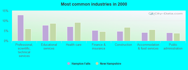
- Professional, scientific, technical services (12.9%)
- Educational services (7.8%)
- Health care (7.0%)
- Finance & insurance (5.2%)
- Construction (4.7%)
- Accommodation & food services (4.2%)
- Public administration (4.0%)
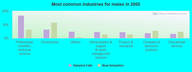
- Professional, scientific, technical services (16.8%)
- Construction (6.5%)
- Utilities (4.9%)
- Administrative & support & waste management services (4.7%)
- Finance & insurance (4.5%)
- Computer & electronic products (4.0%)
- Educational services (3.4%)
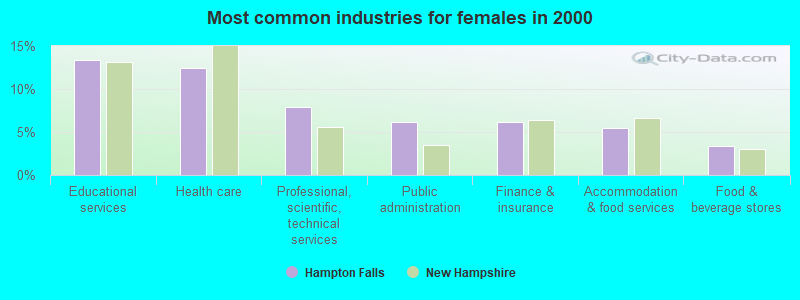
- Educational services (13.4%)
- Health care (12.5%)
- Professional, scientific, technical services (7.9%)
- Public administration (6.1%)
- Finance & insurance (6.1%)
- Accommodation & food services (5.4%)
- Food & beverage stores (3.4%)
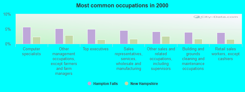
- Computer specialists (5.6%)
- Other management occupations, except farmers and farm managers (5.1%)
- Top executives (4.9%)
- Sales representatives, services, wholesale and manufacturing (4.5%)
- Other sales and related occupations, including supervisors (4.1%)
- Building and grounds cleaning and maintenance occupations (3.9%)
- Retail sales workers, except cashiers (3.8%)
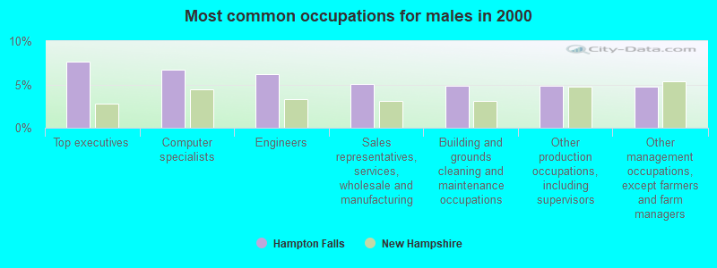
- Top executives (7.6%)
- Computer specialists (6.7%)
- Engineers (6.1%)
- Sales representatives, services, wholesale and manufacturing (5.1%)
- Building and grounds cleaning and maintenance occupations (4.9%)
- Other production occupations, including supervisors (4.9%)
- Other management occupations, except farmers and farm managers (4.7%)
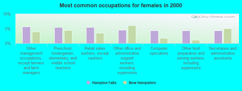
- Other management occupations, except farmers and farm managers (5.7%)
- Preschool, kindergarten, elementary, and middle school teachers (5.4%)
- Retail sales workers, except cashiers (5.4%)
- Other office and administrative support workers, including supervisors (4.5%)
- Computer specialists (4.3%)
- Other food preparation and serving workers, including supervisors (4.3%)
- Secretaries and administrative assistants (4.3%)
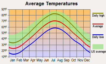
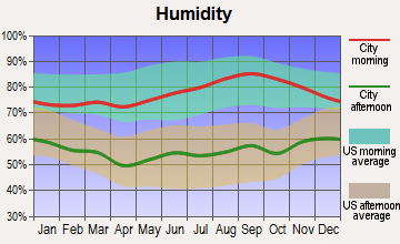
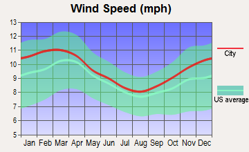
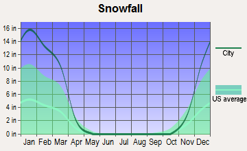
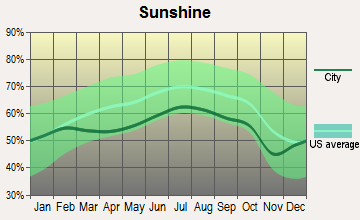
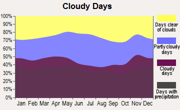
Average climate in Hampton Falls, New Hampshire
Based on data reported by over 4,000 weather stations
(lower is better)
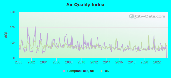
Air Quality Index (AQI) level in 2022 was 64.4. This is about average.
| City: | 64.4 |
| U.S.: | 72.6 |
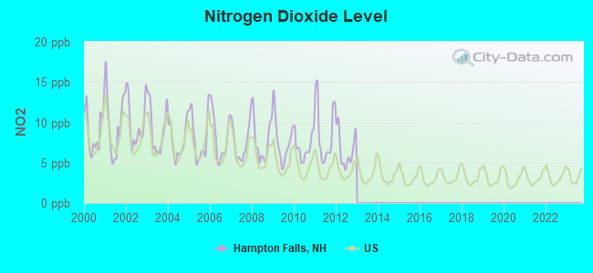
Nitrogen Dioxide (NO2) [ppb] level in 2012 was 6.65. This is worse than average. Closest monitor was 7.7 miles away from the city center.
| City: | 6.65 |
| U.S.: | 5.11 |
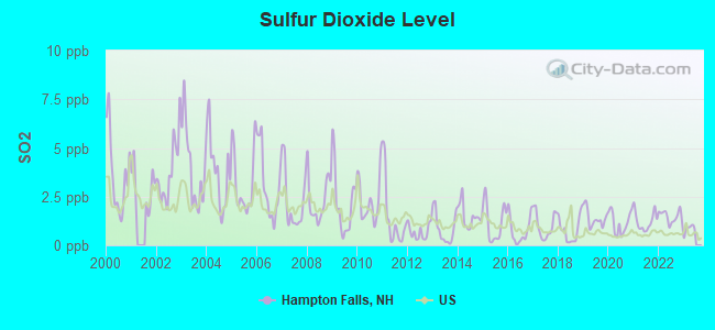
Sulfur Dioxide (SO2) [ppb] level in 2022 was 1.48. This is about average. Closest monitor was 7.7 miles away from the city center.
| City: | 1.48 |
| U.S.: | 1.51 |
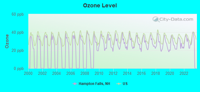
Ozone [ppb] level in 2022 was 29.5. This is about average. Closest monitor was 9.0 miles away from the city center.
| City: | 29.5 |
| U.S.: | 33.3 |
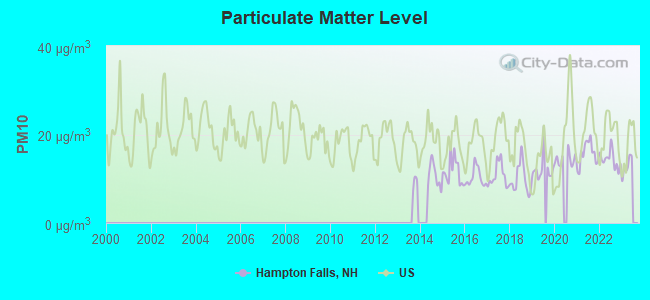
Particulate Matter (PM10) [µg/m3] level in 2022 was 14.4. This is better than average. Closest monitor was 12.4 miles away from the city center.
| City: | 14.4 |
| U.S.: | 19.2 |
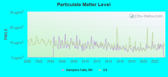
Particulate Matter (PM2.5) [µg/m3] level in 2022 was 6.62. This is better than average. Closest monitor was 12.4 miles away from the city center.
| City: | 6.62 |
| U.S.: | 8.11 |
Tornado activity:
Hampton Falls-area historical tornado activity is near New Hampshire state average. It is 52% smaller than the overall U.S. average.
On 6/9/1953, a category F3 (max. wind speeds 158-206 mph) tornado 5.3 miles away from the Hampton Falls town center injured 5 people and caused between $5000 and $50,000 in damages.
On 9/29/1974, a category F3 tornado 26.4 miles away from the town center injured one person and caused between $50,000 and $500,000 in damages.
Earthquake activity:
Hampton Falls-area historical earthquake activity is significantly above New Hampshire state average. It is 73% smaller than the overall U.S. average.On 10/16/2012 at 23:12:25, a magnitude 4.7 (4.7 ML, Depth: 10.0 mi, Class: Light, Intensity: IV - V) earthquake occurred 48.0 miles away from Hampton Falls center
On 4/20/2002 at 10:50:47, a magnitude 5.3 (5.3 ML, Depth: 3.0 mi, Class: Moderate, Intensity: VI - VII) earthquake occurred 178.3 miles away from Hampton Falls center
On 1/19/1982 at 00:14:42, a magnitude 4.7 (4.5 MB, 4.7 MD, 4.5 LG) earthquake occurred 53.7 miles away from the city center
On 10/7/1983 at 10:18:46, a magnitude 5.3 (5.1 MB, 5.3 LG, 5.1 ML) earthquake occurred 187.5 miles away from Hampton Falls center
On 4/20/2002 at 10:50:47, a magnitude 5.2 (5.2 MB, 4.2 MS, 5.2 MW, 5.0 MW) earthquake occurred 178.1 miles away from the city center
On 8/22/1992 at 12:20:32, a magnitude 4.8 (4.8 MB, 3.8 MS, 4.7 LG, Depth: 6.2 mi) earthquake occurred 265.7 miles away from Hampton Falls center
Magnitude types: regional Lg-wave magnitude (LG), body-wave magnitude (MB), duration magnitude (MD), local magnitude (ML), surface-wave magnitude (MS), moment magnitude (MW)
Natural disasters:
The number of natural disasters in Rockingham County (26) is a lot greater than the US average (15).Major Disasters (Presidential) Declared: 17
Emergencies Declared: 9
Causes of natural disasters: Storms: 12, Floods: 9, Winter Storms: 5, Hurricanes: 4, Snowstorms: 4, Snows: 2, Winds: 2, Blizzard: 1, Snowfall: 1, Tornado: 1 (Note: some incidents may be assigned to more than one category).
Hospitals and medical centers near Hampton Falls:
- EXETER ON HAMPTON CARE AND REHABILITATION CENTER (Nursing Home, about 4 miles away; EXETER, NH)
- OCEANSIDE SKILLED NURSING AND REHABILITATION (Nursing Home, about 4 miles away; HAMPTON, NH)
- SEACOAST HOSPICE (Hospital, about 4 miles away; EXETER, NH)
- FMC DIALYSIS SERVICES OF EXETER (Dialysis Facility, about 5 miles away; EXETER, NH)
- EVENTIDE HOME INC (Nursing Home, about 5 miles away; EXETER, NH)
- EXETER HOSPITAL INC Acute Care Hospitals (about 5 miles away; EXETER, NH)
- EXETER HEALTHCARE (Nursing Home, about 5 miles away; EXETER, NH)
Operable nuclear power plant near Hampton Falls:
- 4 miles: Seabrook in Seabrook, NH.
Colleges/universities with over 2000 students nearest to Hampton Falls:
- Northern Essex Community College (about 13 miles; Haverhill, MA; Full-time enrollment: 4,737)
- University of New Hampshire-Main Campus (about 15 miles; Durham, NH; FT enrollment: 15,243)
- Merrimack College (about 22 miles; North Andover, MA; FT enrollment: 2,734)
- North Shore Community College (about 23 miles; Danvers, MA; FT enrollment: 5,195)
- Endicott College (about 26 miles; Beverly, MA; FT enrollment: 4,064)
- University of Massachusetts-Lowell (about 30 miles; Lowell, MA; FT enrollment: 12,341)
- Salem State University (about 30 miles; Salem, MA; FT enrollment: 8,027)
Public elementary/middle school in Hampton Falls:
- LINCOLN AKERMAN SCHOOL (Students: 252, Location: 8 EXETER RD., Grades: KG-8)
Private elementary/middle school in Hampton Falls:
Points of interest:
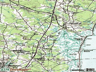
Notable locations in Hampton Falls: Applecrest Farms (A), Wakeda Campground (B), Hampton Falls Fire Department (C), Hampton Falls Free Library (D), Hampton Falls Town Hall (E). Display/hide their locations on the map
Shopping Center: The Mall at Granite Square Shopping Center (1). Display/hide its location on the map
Churches in Hampton Falls include: The Church of Jesus Christ of Latter Day Saints (A), Hampton Falls First Baptist Church (B). Display/hide their locations on the map
Cemeteries: Westview Cemetery (1), Ye Old Neighborhood Cemetery (2), Pike Cemetery (3), Plains Cemetery (4). Display/hide their locations on the map
Lakes, reservoirs, and swamps: Dodge Ponds (A), Dodge Pond (B), Hampton Falls River Reservoir (C), The Gove (D), Hampton Flats (E). Display/hide their locations on the map
Streams, rivers, and creeks: Winkley Brook (A), Kenney Brook (B), Hunts Island Creek (C), Grapevine Run (D), Clay Brook (E), Browns River (F), Ash Brook (G). Display/hide their locations on the map
Park in Hampton Falls: Phillips Park (1). Display/hide its location on the map
Hotel: Hampton Falls Inn (11 Lafayette Road) (1). Display/hide its approximate location on the map
Birthplace of: Ralph Adams Cram - Architect, Benson Leavitt - Politician, Jonathan Leavitt (publisher) - Publisher, Franklin Benjamin Sanborn - Activist.
Drinking water stations with addresses in Hampton Falls that have no violations reported:
- WAKEDA CAMPGROUND (Population served: 350, Primary Water Source Type: Groundwater)
| This town: | 2.7 people |
| New Hampshire: | 2.5 people |
| This town: | 75.4% |
| Whole state: | 66.3% |
| This town: | 7.2% |
| Whole state: | 8.3% |
Likely homosexual households (counted as self-reported same-sex unmarried-partner households)
- Lesbian couples: 0.8% of all households
- Gay men: 1.3% of all households
| This town: | 2.9% |
| Whole state: | 6.5% |
| This town: | 1.3% |
| Whole state: | 2.8% |
Banks with branches in Hampton Falls (2011 data):
- RBS Citizens, National Association: Hampton Falls Branch at 81 Lafayette Road, branch established on 1965/05/20. Info updated 2007/09/19: Bank assets: $106,940.6 mil, Deposits: $75,690.2 mil, headquarters in Providence, RI, positive income, 1135 total offices, Holding Company: Uk Financial Investments Limited
For population 15 years and over in Hampton Falls:
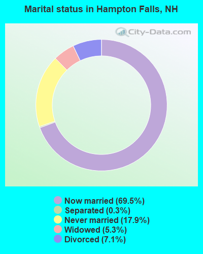
- Never married: 17.9%
- Now married: 69.5%
- Separated: 0.3%
- Widowed: 5.3%
- Divorced: 7.1%
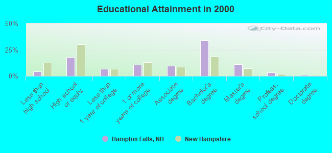
For population 25 years and over in Hampton Falls:
- High school or higher: 95.5%
- Bachelor's degree or higher: 49.8%
- Graduate or professional degree: 15.8%
- Unemployed: 1.2%
- Mean travel time to work (commute): 30.2 minutes
| Here: | 8.8 |
| New Hampshire average: | 10.9 |


Graphs represent county-level data. Detailed 2008 Election Results
Religion statistics for Hampton Falls, NH (based on Rockingham County data)


| Religion | Adherents | Congregations |
|---|---|---|
| Catholic | 84,697 | 24 |
| Mainline Protestant | 19,072 | 78 |
| Evangelical Protestant | 7,456 | 61 |
| Other | 3,490 | 20 |
| Orthodox | 200 | 1 |
| None | 180,308 | - |
Food Environment Statistics:
| Rockingham County: | 1.59 / 10,000 pop. |
| New Hampshire: | 2.14 / 10,000 pop. |
| Rockingham County: | 0.17 / 10,000 pop. |
| New Hampshire: | 0.15 / 10,000 pop. |
| Here: | 1.86 / 10,000 pop. |
| State: | 1.78 / 10,000 pop. |
| Rockingham County: | 3.31 / 10,000 pop. |
| State: | 4.02 / 10,000 pop. |
| Rockingham County: | 9.56 / 10,000 pop. |
| State: | 9.70 / 10,000 pop. |
| Here: | 7.6% |
| New Hampshire: | 7.6% |
| Rockingham County: | 23.3% |
| New Hampshire: | 24.4% |
| Here: | 16.8% |
| New Hampshire: | 15.9% |
7.69% of this county's 2021 resident taxpayers lived in other counties in 2020 ($114,534 average adjusted gross income)
| Here: | 7.69% |
| New Hampshire average: | 7.66% |
0.01% of residents moved from foreign countries ($203 average AGI)
Rockingham County: 0.01% New Hampshire average: 0.01%
Top counties from which taxpayers relocated into this county between 2020 and 2021:
| from Essex County, MA | |
| from Hillsborough County, NH | |
| from Middlesex County, MA |
6.82% of this county's 2020 resident taxpayers moved to other counties in 2021 ($88,778 average adjusted gross income)
| Here: | 6.82% |
| New Hampshire average: | 6.80% |
0.01% of residents moved to foreign countries ($126 average AGI)
Rockingham County: 0.01% New Hampshire average: 0.01%
Top counties to which taxpayers relocated from this county between 2020 and 2021:
| to Hillsborough County, NH | |
| to Strafford County, NH | |
| to Essex County, MA |
Businesses in Hampton Falls, NH
- Ace Hardware: 1
- MasterBrand Cabinets: 4
Strongest AM radio stations in Hampton Falls:
- WGIP (1540 AM; 5 kW; EXETER, NH; Owner: CAPSTAR TX LIMITED PARTNERSHIP)
- WRKO (680 AM; 50 kW; BOSTON, MA; Owner: ENTERCOM BOSTON LICENSE, LLC)
- WBZ (1030 AM; 50 kW; BOSTON, MA; Owner: INFINITY BROADCASTING OPERATIONS, INC.)
- WEEI (850 AM; 50 kW; BOSTON, MA; Owner: ENTERCOM BOSTON LICENSE, LLC)
- WWZN (1510 AM; 50 kW; BOSTON, MA; Owner: ROSE CITY RADIO CORPORATION)
- WDER (1320 AM; 10 kW; DERRY, NH; Owner: BLOUNT COMMUNICATIONS, INC. OF NH)
- WGIN (930 AM; 10 kW; ROCHESTER, NH; Owner: CAPSTAR TX LIMITED PARTNERSHIP)
- WKOX (1200 AM; 50 kW; FRAMINGHAM, MA; Owner: CAPSTAR TX LIMITED PARTNERSHIP)
- WNBP (1450 AM; 1 kW; NEWBURYPORT, MA; Owner: RADIO NEWBURYPORT, LLC)
- WBIX (1060 AM; 40 kW; NATICK, MA; Owner: LANGER BROADCASTING CORPORATION)
- WTSN (1270 AM; 5 kW; DOVER, NH; Owner: GARRISON CITY BROADCASTING, INC.)
- WCRN (830 AM; 50 kW; WORCESTER, MA; Owner: CARTER BROADCASTING CORPORATION)
- WRCA (1330 AM; 25 kW; WALTHAM, MA; Owner: WRCA LICENSE, LLC)
Strongest FM radio stations in Hampton Falls:
- WSAK (102.1 FM; HAMPTON, NH; Owner: CITADEL BROADCASTING COMPANY)
- WNEF (91.7 FM; NEWBURYPORT, MA; Owner: UNIVERSITY OF MASSACHUSETTS)
- WERZ (107.1 FM; EXETER, NH; Owner: CAPSTAR TX LIMITED PARTNERSHIP)
- WHEB (100.3 FM; PORTSMOUTH, NH; Owner: CAPSTAR TX LIMITED PARTNERSHIP)
- WXRV (92.5 FM; HAVERHILL, MA; Owner: BEANPOT BROADCASTING CORP.)
- WUBB (95.3 FM; YORK CENTER, ME; Owner: CAPSTAR TX LIMITED PARTNERSHIP)
- WKLB-FM (99.5 FM; LOWELL, MA; Owner: GREATER BOSTON RADIO, INC.)
- WGIR-FM (101.1 FM; MANCHESTER, NH; Owner: CAPSTAR TX LIMITED PARTNERSHIP)
- WSCY (106.9 FM; MOULTONBOROUGH, NH; Owner: NORTHEAST COMMUNICATIONS CORPORATION)
- WXKS-FM (107.9 FM; MEDFORD, MA; Owner: AMFM RADIO LICENSES, L.L.C.)
- WOKQ (97.5 FM; DOVER, NH; Owner: CITADEL BROADCASTING COMPANY)
- WQLL (96.5 FM; BEDFORD, NH; Owner: SAGA COMMUNICATIONS OF NEW ENGLAND, LLC)
- WMJX (106.7 FM; BOSTON, MA; Owner: GREATER BOSTON RADIO, INC.)
- WLMW (90.7 FM; MANCHESTER, NH; Owner: KNOWLEDGE FOR LIFE)
- WZID (95.7 FM; MANCHESTER, NH; Owner: SAGA COMMUNICATIONS OF NEW ENGLAND, LLC)
- WSHK (105.3 FM; KITTERY, ME; Owner: CITADEL BROADCASTING COMPANY)
- W227AM (93.3 FM; ANDOVER, MA; Owner: GREATER BOSTON RADIO, INC.)
- WQSX (93.7 FM; LAWRENCE, MA; Owner: ENTERCOM BOSTON LICENSE, LLC)
- WFEX (92.1 FM; PETERBOROUGH, NH; Owner: FNX BROADCASTING OF NEW HAMPSHIRE LLC)
- WBMX (98.5 FM; BOSTON, MA; Owner: INFINITY RADIO OPERATIONS INC.)
TV broadcast stations around Hampton Falls:
- WHDN-LP (Channel 26; BOSTON, MA; Owner: GUENTER MARKSTEINER)
- WFXZ-CA (Channel 24; BOSTON, MA; Owner: BOSTON BROADCASTING CORP.)
- WMEA-TV (Channel 26; BIDDEFORD, ME; Owner: MAINE PUBLIC BROADCASTING CORP.)
- WCVB-TV (Channel 5; BOSTON, MA; Owner: WCVB HEARST-ARGYLE TV, INC.)
- WGBH-TV (Channel 2; BOSTON, MA; Owner: WGBH EDUCATIONAL FOUNDATION)
- WENH-TV (Channel 11; DURHAM, NH; Owner: UNIVERSITY OF NEW HAMPSHIRE)
- WMFP (Channel 62; LAWRENCE, MA; Owner: WSAH LICENSE, INC.)
- WSBK-TV (Channel 38; BOSTON, MA; Owner: VIACOM INC.)
- WLVI-TV (Channel 56; CAMBRIDGE, MA; Owner: WLVI, INC.)
- WBZ-TV (Channel 4; BOSTON, MA; Owner: VIACOM INC.)
- WGBX-TV (Channel 44; BOSTON, MA; Owner: WGBH EDUCATIONAL FOUNDATION)
- WFXT (Channel 25; BOSTON, MA; Owner: FOX TELEVISION STATIONS INC.)
- WBPX (Channel 68; BOSTON, MA; Owner: PAXSON BOSTON-68 LICENSE, INC.)
- WUTF (Channel 66; MARLBOROUGH, MA; Owner: TELEFUTURA BOSTON LLC)
- WNDS (Channel 50; DERRY, NH; Owner: CTV OF DERRY, INC)
- Hampton Falls, New Hampshire
- Fatal accident count20
- Vehicles involved in fatal accidents29
- Fatal accidents involving drunk persons:5
- Fatalities24
- Persons involved in fatal accidents47
- Pedestrians involved in fatal accidents0
- New Hampshire average
- Fatal accident count2129
- Vehicles involved in fatal accidents3154
- Fatal accidents involving drunk persons797
- Fatalities2328
- Persons involved in fatal accidents4933
- Pedestrians involved in fatal accidents187
- National Bridge Inventory (NBI) Statistics
- 4Number of bridges
- 52ft / 15.6mTotal length
- $6,284,000Total costs
- 173,910Total average daily traffic
- 15,558Total average daily truck traffic
FCC Registered Antenna Towers:
7- KELLYE E ABERNATHY, Rt 88 & 95 (Lat: 42.921667 Lon: -70.867500), Type: 30.5, Overall height: 30.5 m, Registrant: Cingular Wireless LLC, Kellye.E.Abernathy@cingular.Com, , Plano, Phone: (469) 229-7422
- DANIEL L GOULET, Rt 88 & 95 (Lat: 42.921667 Lon: -70.867500), Type: 30.5, Overall height: 30.5 m, Registrant: Telecorp Pcs LLC, Www.Telecorp1.Com, , Nashu-a, Phone: (603) 897-2300
- Douglas I Brandon, Rt 88 & 95 (Lat: 42.921667 Lon: -70.867500), Type: 30.5, Overall height: 30.5 m, Registrant: At&t Wireless Services, Inc., David.Jatlow@attws.Com, , Washi-ngton, Phone: (202) 223-9222
- David C Jatlow, Rt 88 & 95 (Lat: 42.921667 Lon: -70.867500), Type: 30.5, Overall height: 30.5 m, Registrant: At&t Wireless Services, Inc., David.Jatlow@attws.Com, , Washi-ngton, Phone: (202) 223-9222
- David C Jatlow, Rt 88 & 95 (Lat: 42.921667 Lon: -70.867500), Type: 30.5, Overall height: 30.5 m, Registrant: New Cingular Wireless Pcs, LLC, Kellye.E.Abernathy@cingular.Com, , Plano, Phone: (469) 229-7422
- Lisa Burke, Hampton Falls Site (Lat: 42.910833 Lon: -70.878972), Type: 57.9, Overall height: 57.9 m, Registrant: Aviation Systems, Inc., Crisj@aviationsystems.Com, , Torra-nce, Phone: (310) 530-3188
- Rt 88 & 95 (Lat: 42.921667 Lon: -70.867500), Type: 30.5, Overall height: 30.5 m, Registrant: Telecorp Pcs LLC, Www.Telecorp1.Com, , Nashu-a, Phone: (603) 897-2300
FCC Registered Broadcast Land Mobile Towers:
2- 95 N 3.0 Ssca T (Lat: 42.922944 Lon: -70.867972), Type: Sign, Structure height: 9.1 m, Call Sign: WQQQ820, Licensee ID: L00307774,
Assigned Frequencies: 4945.00 MHz, Grant Date: 11/17/2022, Expiration Date: 02/13/2033, Certifier: David Chase, Registrant: State Of New Hampshire, Department Of Transportation, Division Of Operations, Seven Hazen Drive, Concord, NH 03302-0483, Phone: (603) 271-6862, Fax: (603) 271-8626, Email:
- Mobile, Lat: 42.940944 Lon: -70.910389, Call Sign: WRXS617,
Assigned Frequencies: 160.147 MHz, Grant Date: 06/23/2023, Expiration Date: 06/23/2033, Certifier: Michael P Leary, Registrant: Commercial Marine Electronics, 238 Stockbridge Rd. Unit C, Scituate, MA 02066, Phone: (781) 545-7883, Email:
FCC Registered Amateur Radio Licenses:
23 (See the full list of FCC Registered Amateur Radio Licenses in Hampton Falls)FAA Registered Aircraft:
10 (See the full list of FAA Registered Aircraft in Hampton Falls)2002 - 2018 National Fire Incident Reporting System (NFIRS) incidents
- Fire incident types reported to NFIRS in Hampton Falls, NH
- 8753.7%Structure Fires
- 3521.6%Outside Fires
- 2817.3%Mobile Property/Vehicle Fires
- 127.4%Other
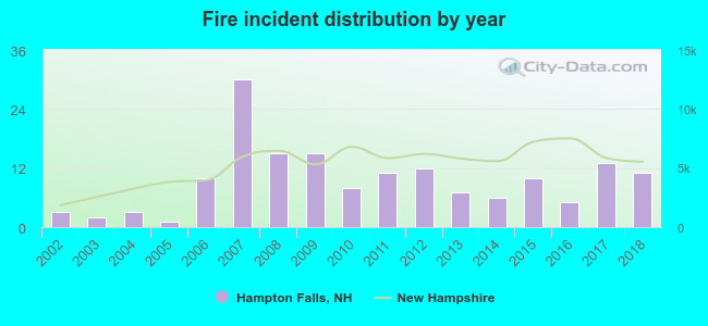 According to the data from the years 2002 - 2018 the average number of fires per year is 10. The highest number of fires - 30 took place in 2007, and the least - 1 in 2005. The data has a growing trend.
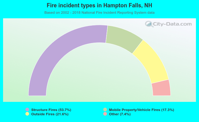 When looking into fire subcategories, the most reports belonged to: Structure Fires (53.7%), and Outside Fires (21.6%).
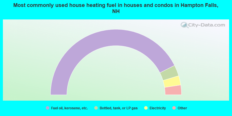
- 85.2%Fuel oil, kerosene, etc.
- 5.4%Bottled, tank, or LP gas
- 4.6%Electricity
- 3.0%Wood
- 0.8%Utility gas
- 0.6%Other fuel
- 0.3%Coal or coke
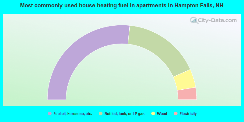
- 53.3%Fuel oil, kerosene, etc.
- 33.3%Bottled, tank, or LP gas
- 8.0%Wood
- 5.3%Electricity
Hampton Falls compared to New Hampshire state average:
- Median household income above state average.
- Median house value above state average.
- Unemployed percentage significantly below state average.
- Black race population percentage significantly below state average.
- Hispanic race population percentage significantly below state average.
- Foreign-born population percentage significantly below state average.
- Renting percentage significantly below state average.
- Length of stay since moving in significantly above state average.
- Number of rooms per house significantly below state average.
- House age significantly below state average.
- Percentage of population with a bachelor's degree or higher above state average.

|
|
Total of 83 patent applications in 2008-2024.