Jurupa, California
Submit your own pictures of this place and show them to the world
- OSM Map
- General Map
- Google Map
- MSN Map

| Males: 56,725 | |
| Females: 55,500 |
| Median resident age: | 30.0 years |
| California median age: | 33.3 years |
Zip code: 92509
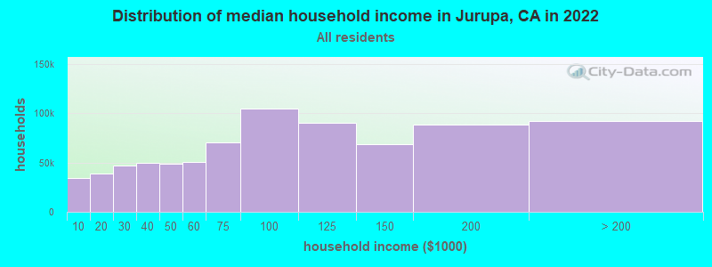
| Jurupa: | $88,585 |
| CA: | $91,551 |
Estimated per capita income in 2022: $28,905 (it was $15,231 in 2000)
Jurupa CCD income, earnings, and wages data
Estimated median house or condo value in 2022: $547,995 (it was $133,200 in 2000)
| Jurupa: | $547,995 |
| CA: | $715,900 |
Mean prices in 2022: all housing units: $586,167; detached houses: $631,165; townhouses or other attached units: $625,082; in 2-unit structures: $464,831; in 3-to-4-unit structures: $482,529; in 5-or-more-unit structures: $526,423; mobile homes: $178,284; occupied boats, rvs, vans, etc.: $86,227
Detailed information about poverty and poor residents in Jurupa, CA


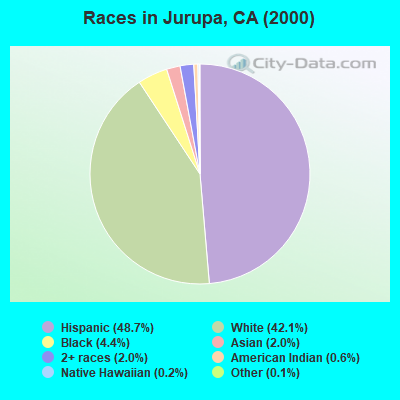
- 41,41548.7%Hispanic
- 35,80142.1%White alone
- 3,7194.4%Black alone
- 1,7272.0%Asian alone
- 1,6602.0%Two or more races
- 5280.6%American Indian alone
- 1560.2%Native Hawaiian and Other
Pacific Islander alone - 1000.1%Other race alone
According to our research of California and other state lists, there were 14 registered sex offenders living in Jurupa, California as of May 01, 2024.
The ratio of all residents to sex offenders in Jurupa is 8,016 to 1.
The ratio of registered sex offenders to all residents in this city is much lower than the state average.
 Recent articles from our blog. Our writers, many of them Ph.D. graduates or candidates, create easy-to-read articles on a wide variety of topics.

Current Local Time: PST time zone
Land area: 60.8 square miles.
Population density: 1,847 people per square mile (low).

| Jurupa CCD: | 0.8% ($1,104) |
| California: | 0.8% ($1,564) |
Nearest city with pop. 200,000+: Riverside, CA  (5.8 miles , pop. 255,166).
Nearest city with pop. 1,000,000+: Los Angeles, CA (51.8 miles , pop. 3,694,820).
Nearest cities:
), ), ), )Latitude: 34.00 N, Longitude: 117.48 W
Area code commonly used in this area: 909

| Here: | 5.2% |
| California: | 5.1% |
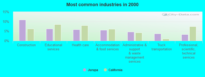
- Construction (10.9%)
- Educational services (6.3%)
- Health care (5.9%)
- Accommodation & food services (5.6%)
- Administrative & support & waste management services (4.7%)
- Truck transportation (3.7%)
- Professional, scientific, technical services (3.3%)
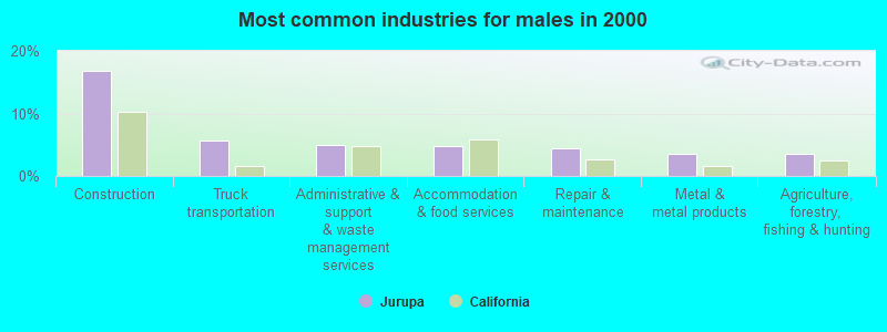
- Construction (16.8%)
- Truck transportation (5.6%)
- Administrative & support & waste management services (5.0%)
- Accommodation & food services (4.8%)
- Repair & maintenance (4.4%)
- Metal & metal products (3.5%)
- Agriculture, forestry, fishing & hunting (3.5%)
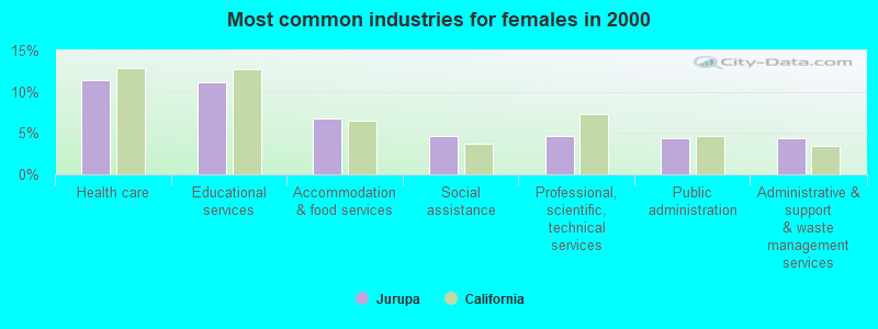
- Health care (11.4%)
- Educational services (11.1%)
- Accommodation & food services (6.8%)
- Social assistance (4.7%)
- Professional, scientific, technical services (4.6%)
- Public administration (4.4%)
- Administrative & support & waste management services (4.3%)
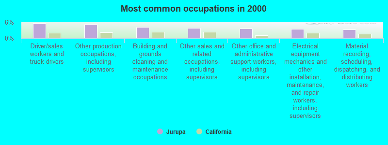
- Driver/sales workers and truck drivers (5.6%)
- Other production occupations, including supervisors (5.2%)
- Building and grounds cleaning and maintenance occupations (4.2%)
- Other sales and related occupations, including supervisors (3.9%)
- Other office and administrative support workers, including supervisors (3.7%)
- Electrical equipment mechanics and other installation, maintenance, and repair workers, including supervisors (3.4%)
- Material recording, scheduling, dispatching, and distributing workers (3.2%)
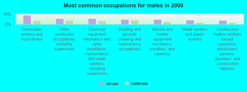
- Driver/sales workers and truck drivers (9.0%)
- Other production occupations, including supervisors (5.7%)
- Electrical equipment mechanics and other installation, maintenance, and repair workers, including supervisors (5.7%)
- Building and grounds cleaning and maintenance occupations (4.8%)
- Vehicle and mobile equipment mechanics, installers, and repairers (4.7%)
- Metal workers and plastic workers (4.1%)
- Construction traders workers except carpenters, electricians, painters, plumbers, and construction laborers (3.9%)
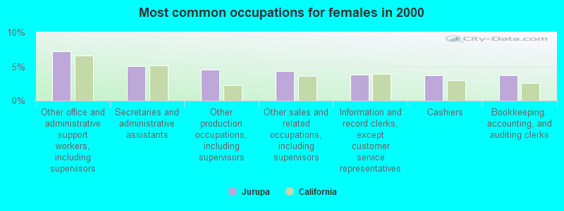
- Other office and administrative support workers, including supervisors (7.2%)
- Secretaries and administrative assistants (5.1%)
- Other production occupations, including supervisors (4.5%)
- Other sales and related occupations, including supervisors (4.4%)
- Information and record clerks, except customer service representatives (3.8%)
- Cashiers (3.7%)
- Bookkeeping, accounting, and auditing clerks (3.7%)
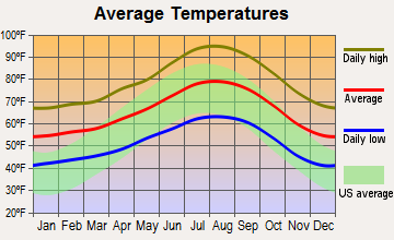
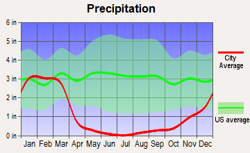
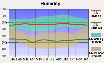
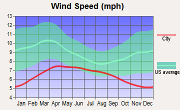
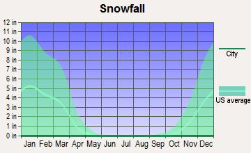
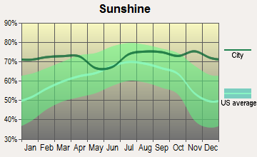
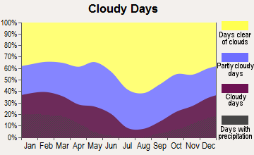
Average climate in Jurupa, California
Based on data reported by over 4,000 weather stations
(lower is better)
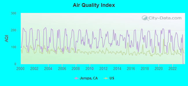
Air Quality Index (AQI) level in 2022 was 133. This is significantly worse than average.
| City: | 133 |
| U.S.: | 73 |
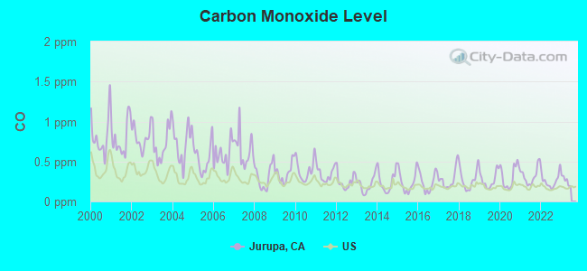
Carbon Monoxide (CO) [ppm] level in 2022 was 0.260. This is about average. Closest monitor was 0.8 miles away from the city center.
| City: | 0.260 |
| U.S.: | 0.251 |
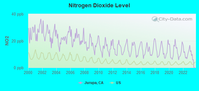
Nitrogen Dioxide (NO2) [ppb] level in 2022 was 11.0. This is significantly worse than average. Closest monitor was 0.8 miles away from the city center.
| City: | 11.0 |
| U.S.: | 5.1 |
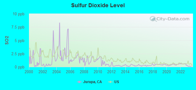
Sulfur Dioxide (SO2) [ppb] level in 2022 was 0.523. This is significantly better than average. Closest monitor was 2.6 miles away from the city center.
| City: | 0.523 |
| U.S.: | 1.515 |
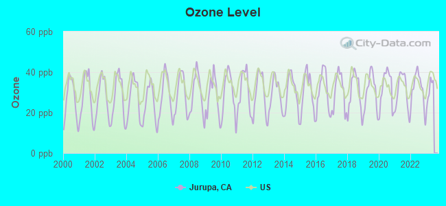
Ozone [ppb] level in 2022 was 31.8. This is about average. Closest monitor was 0.8 miles away from the city center.
| City: | 31.8 |
| U.S.: | 33.3 |
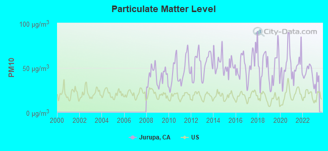
Particulate Matter (PM10) [µg/m3] level in 2022 was 45.4. This is significantly worse than average. Closest monitor was 0.8 miles away from the city center.
| City: | 45.4 |
| U.S.: | 19.2 |
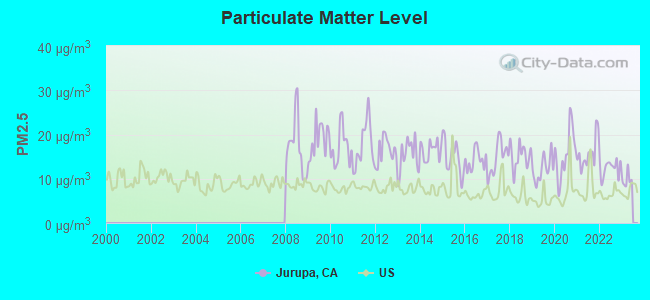
Particulate Matter (PM2.5) [µg/m3] level in 2022 was 12.4. This is significantly worse than average. Closest monitor was 0.8 miles away from the city center.
| City: | 12.4 |
| U.S.: | 8.1 |
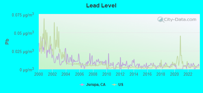
Lead (Pb) [µg/m3] level in 2023 was 0.00426. This is significantly better than average. Closest monitor was 2.6 miles away from the city center.
| City: | 0.00426 |
| U.S.: | 0.00931 |
Earthquake activity:
Jurupa-area historical earthquake activity is significantly above California state average. It is 7248% greater than the overall U.S. average.On 6/28/1992 at 11:57:34, a magnitude 7.6 (6.2 MB, 7.6 MS, 7.3 MW, Depth: 0.7 mi, Class: Major, Intensity: VIII - XII) earthquake occurred 55.8 miles away from Jurupa center, causing 3 deaths (1 shaking deaths, 2 other deaths) and 400 injuries, causing $100,000,000 total damage and $40,000,000 insured losses
On 7/21/1952 at 11:52:14, a magnitude 7.7 (7.7 UK) earthquake occurred 111.1 miles away from Jurupa center, causing $50,000,000 total damage
On 10/16/1999 at 09:46:44, a magnitude 7.4 (6.3 MB, 7.4 MS, 7.2 MW, 7.3 ML) earthquake occurred 69.7 miles away from the city center
On 4/21/1918 at 22:32:30, a magnitude 6.8 (6.8 UK, Class: Strong, Intensity: VII - IX) earthquake occurred 12.9 miles away from the city center
On 5/19/1940 at 04:36:40, a magnitude 7.2 (7.2 UK) earthquake occurred 115.8 miles away from Jurupa center, causing $33,000,000 total damage
On 6/28/1992 at 15:05:30, a magnitude 6.9 (6.3 MB, 6.7 MS, 6.5 MW, 6.9 ME, Depth: 3.1 mi) earthquake occurred 43.0 miles away from Jurupa center
Magnitude types: body-wave magnitude (MB), energy magnitude (ME), local magnitude (ML), surface-wave magnitude (MS), moment magnitude (MW)
Natural disasters:
The number of natural disasters in Riverside County (46) is a lot greater than the US average (15).Major Disasters (Presidential) Declared: 27
Emergencies Declared: 1
Causes of natural disasters: Fires: 22, Floods: 20, Storms: 8, Winter Storms: 8, Landslides: 6, Mudslides: 5, Heavy Rains: 2, Earthquake: 1, Flash Flood: 1, Freeze: 1, Hurricane: 1, Tornado: 1, Tropical Storm: 1, Other: 1 (Note: some incidents may be assigned to more than one category).
Hospitals and medical centers near Jurupa:
- CAMI HOUSE (Hospital, about 2 miles away; RIVERSIDE, CA)
- MAVERICK HOUSE (Hospital, about 2 miles away; RIVERSIDE, CA)
- LAUREL PARK HOUSE (Hospital, about 2 miles away; RIVERSIDE, CA)
- LIFEHOUSE OF RIVERSIDE HEALTHCARE CENTER (Nursing Home, about 2 miles away; RIVERSIDE, CA)
- MILLER'S PROGRESSIVE CARE (Nursing Home, about 2 miles away; RIVERSIDE, CA)
- LINARES DIVISION (Hospital, about 3 miles away; RIVERSIDE, CA)
- MT. RUBIDOUX NURSING CENTER (Nursing Home, about 4 miles away; RUBIDOUX, CA)
Amtrak stations near Jurupa:
- 7 miles: RIVERSIDE (4066 VINE ST.) - Bus Station . Services: fully wheelchair accessible, public payphones, full-service food facilities, free short-term parking, free long-term parking, call for car rental service, call for taxi service, public transit connection.
- 11 miles: ONTARIO (228 S. PLUM ST.) . Services: fully wheelchair accessible, public payphones, vending machines, free short-term parking, call for taxi service.
- 13 miles: MORENO VALLEY (ARCO MINI MART, 2624 E. ALESSANDRO BLVD.) - Bus Station . Services: public payphones.
Colleges/universities with over 2000 students nearest to Jurupa:
- California Baptist University (about 6 miles; Riverside, CA; Full-time enrollment: 6,085)
- Riverside City College (about 6 miles; Riverside, CA; FT enrollment: 10,661)
- La Sierra University (about 7 miles; Riverside, CA; FT enrollment: 2,205)
- Norco College (about 8 miles; Norco, CA; FT enrollment: 4,916)
- Universal Technical Institute of California Inc (about 9 miles; Rancho Cucamonga, CA; FT enrollment: 4,158)
- University of California-Riverside (about 9 miles; Riverside, CA; FT enrollment: 20,647)
- San Bernardino Valley College (about 12 miles; San Bernardino, CA; FT enrollment: 7,444)
Public high schools in Jurupa:
- PATRIOT HIGH (Students: 1,663, Location: 4355 CAMINO REAL, Grades: 9-12)
- JURUPA VALLEY HIGH (Students: 1,428, Location: 10551 BELLEGRAVE AVE., Grades: 9-12)
- RUBIDOUX HIGH (Students: 1,109, Location: 4250 OPAL ST., Grades: 9-12)
- RIVERCREST PREPARATORY (Students: 593, Location: 10551 BELLEGRAVE AVE., Grades: 9-12)
- STEPS COMMUNITY DAY (Students: 29, Location: 4041 PACIFIC AVE., Grades: 7-12)
- NUEVA VISTA CONTINUATION HIGH (Students: 28, Location: 6836 34TH ST., Grades: 9-12)
- RIO VISTA HIGH (Students: 14, Location: 6836 34TH ST., Grades: 9-12)
Biggest public elementary/middle schools in Jurupa:
- JURUPA MIDDLE (Students: 1,043, Location: 8700 GALENA ST., Grades: 7-8)
- MIRA LOMA MIDDLE (Students: 868, Location: 5051 STEVE ST., Grades: 7-8)
- MISSION MIDDLE (Students: 800, Location: 5961 MUSTANG LN., Grades: 7-8)
- LOUIS VANDERMOLEN FUNDAMENTAL ELEMENTARY (Students: 596, Location: 6744 CARNELIAN ST., Grades: KG-6)
- TROTH STREET ELEMENTARY (Students: 562, Location: 5565 TROTH ST., Grades: KG-6)
- CAMINO REAL ELEMENTARY (Students: 516, Location: 4655 CAMINO REAL, Grades: KG-6)
- WEST RIVERSIDE ELEMENTARY (Students: 476, Location: 3972 RIVERVIEW DR., Grades: KG-6)
- STONE AVENUE ELEMENTARY (Students: 469, Location: 5111 STONE AVE., Grades: KG-6)
- SKY COUNTRY ELEMENTARY (Students: 456, Location: 5520 LUCRETIA AVE., Grades: KG-6)
- GRANITE HILL ELEMENTARY (Students: 439, Location: 9371 GRANITE HILL, Grades: KG-6)
Points of interest:
Notable locations in Jurupa: Fuller Rancho (A), Rubidoux Drive-In (B), Mira Loma Space Center (C), Galleano Winery (D), Country Village Golf Course (E), Paradise Knolls Golf Course (F), Jurupa Hills Country Club (G), Indian Hills Golf Course (H), Jurupa Cultural Center (I), Riverside County Fire Department Station 27 Eastvale (J), Speedway Volunteer Fire Department (K), Riverside County Fire Department Station 18 West Riverside (L), Riverside County Fire Department Station 38 Rubidoux (M), Louis Rubidoux Branch Riverside City and County Public Library (N), Riverside County Fire Department Station 16 Pedley (O), Riverside County Fire Department Station 17 Glen Avon (P), Glen Avon Branch Riverside City and County Public Library (Q), The Church of Jesus Christ of Latter Day Saints Jurupa Library (R), Riverside County Library (S). Display/hide their locations on the map
Shopping Centers: Pedley Square Shopping Center (1), De Anza Country Shopping Center (2), Rubidoux Shopping Center (3), Glen Avon Market Shopping Center (4). Display/hide their locations on the map
Churches in Jurupa include: Vision Plus Ministries (A), The Real Life Center (B), The Church of Jesus Christ of Latter Day Saints (C), Rubidoux Missionary Baptist Church (D), Rubidoux First Assembly Church (E), Power of the Word Fellowship Church (F), Newness of Life Christian Ministry (G), New Century Baptist Church (H), New Birth Missionary Baptist Church (I). Display/hide their locations on the map
Lakes and reservoirs: Swan Lake (A), Horseshoe Lake (B). Display/hide their locations on the map
Creeks: Chino Creek (A), Day Creek (B), Mill Creek (C). Display/hide their locations on the map
Parks in Jurupa include: Avalon Park (1), Boulder Hill Park (2), Prado County Park (3), Clays One Thousand Ranch Park (4), Jensen Ranch Historical Park (5), Louis Rubidoux Nature Center (6), West Riverside Memorial Park (7), Rancho Jurupa Park (8). Display/hide their locations on the map
| This place: | 3.9 people |
| California: | 2.9 people |
| This place: | 83.9% |
| Whole state: | 68.7% |
| This place: | 7.0% |
| Whole state: | 7.2% |
Likely homosexual households (counted as self-reported same-sex unmarried-partner households)
- Lesbian couples: 0.4% of all households
- Gay men: 0.3% of all households
| This place: | 16.9% |
| Whole state: | 14.2% |
| This place: | 8.3% |
| Whole state: | 6.3% |
People in group quarters in Jurupa in 2010:
- 543 people in nursing facilities/skilled-nursing facilities
- 78 people in group homes intended for adults
- 55 people in residential treatment centers for adults
- 47 people in other noninstitutional facilities
- 23 people in correctional residential facilities
- 17 people in group homes for juveniles (non-correctional)
- 15 people in residential treatment centers for juveniles (non-correctional)
- 15 people in workers' group living quarters and job corps centers
People in group quarters in Jurupa in 2000:
- 372 people in nursing homes
- 216 people in other noninstitutional group quarters
- 120 people in homes for the mentally ill
- 89 people in homes for the mentally retarded
- 64 people in training schools for juvenile delinquents
- 58 people in other group homes
- 28 people in agriculture workers' dormitories on farms
- 6 people in homes or halfway houses for drug/alcohol abuse
For population 15 years and over in Jurupa:
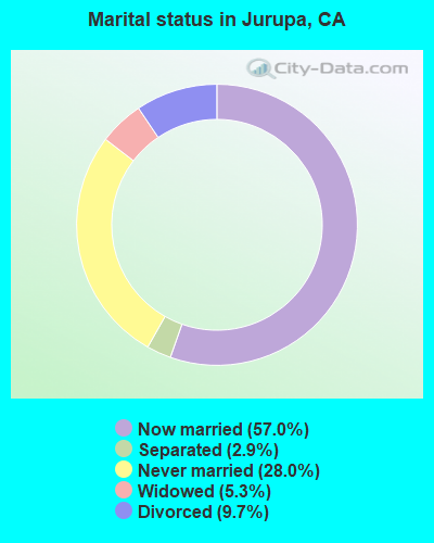
- Never married: 28.0%
- Now married: 57.0%
- Separated: 2.9%
- Widowed: 5.3%
- Divorced: 9.7%
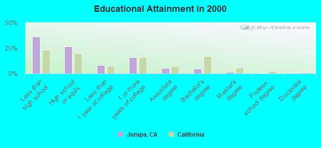
For population 25 years and over in Jurupa:
- High school or higher: 63.5%
- Bachelor's degree or higher: 7.3%
- Graduate or professional degree: 2.3%
- Unemployed: 8.2%
- Mean travel time to work (commute): 32.2 minutes
| Here: | 16.7 |
| California average: | 16.1 |
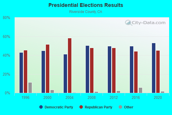
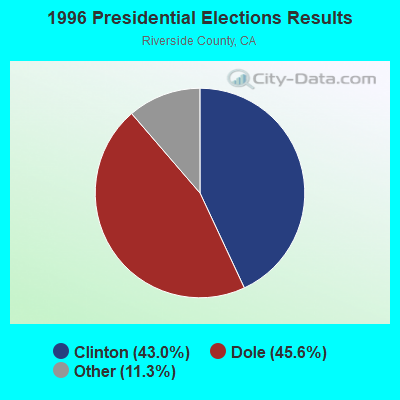
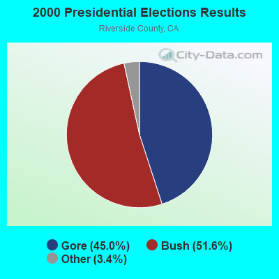
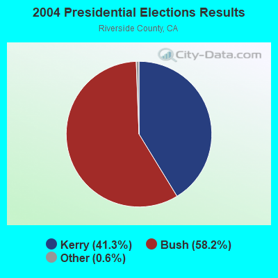
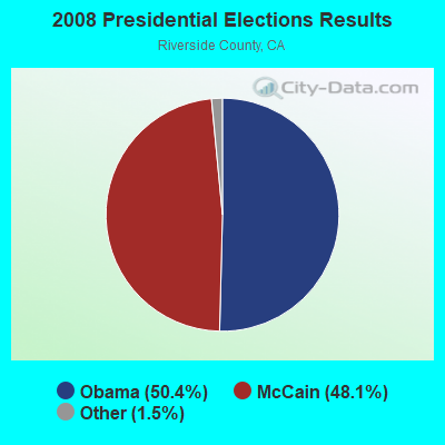
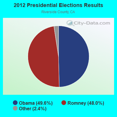
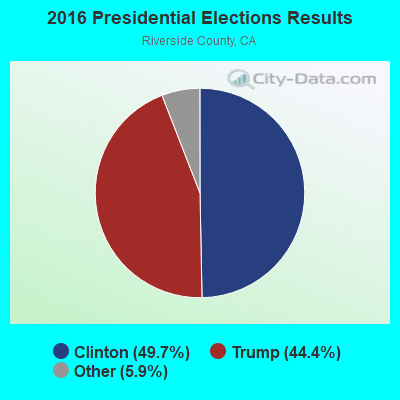
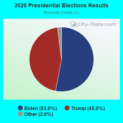
Graphs represent county-level data. Detailed 2008 Election Results
Religion statistics for Jurupa, CA (based on Riverside County data)
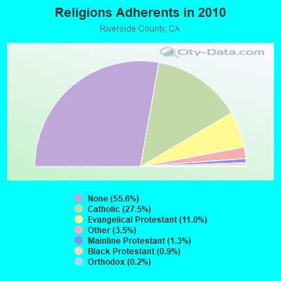
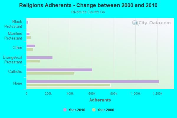
| Religion | Adherents | Congregations |
|---|---|---|
| Catholic | 602,765 | 51 |
| Evangelical Protestant | 240,306 | 741 |
| Other | 77,581 | 194 |
| Mainline Protestant | 29,535 | 103 |
| Black Protestant | 19,170 | 40 |
| Orthodox | 3,647 | 11 |
| None | 1,216,637 | - |
Food Environment Statistics:
| This county: | 1.60 / 10,000 pop. |
| California: | 2.14 / 10,000 pop. |
| This county: | 0.05 / 10,000 pop. |
| State: | 0.04 / 10,000 pop. |
| This county: | 0.44 / 10,000 pop. |
| California: | 0.62 / 10,000 pop. |
| Riverside County: | 1.51 / 10,000 pop. |
| California: | 1.49 / 10,000 pop. |
| Riverside County: | 5.45 / 10,000 pop. |
| California: | 7.42 / 10,000 pop. |
| Here: | 7.7% |
| California: | 7.3% |
| Riverside County: | 24.5% |
| California: | 21.3% |
| Riverside County: | 15.2% |
| California: | 17.9% |
7.19% of this county's 2021 resident taxpayers lived in other counties in 2020 ($71,521 average adjusted gross income)
| Here: | 7.19% |
| California average: | 5.19% |
0.03% of residents moved from foreign countries ($210 average AGI)
Riverside County: 0.03% California average: 0.03%
Top counties from which taxpayers relocated into this county between 2020 and 2021:
| from Los Angeles County, CA | |
| from San Bernardino County, CA | |
| from Orange County, CA |
6.28% of this county's 2020 resident taxpayers moved to other counties in 2021 ($64,593 average adjusted gross income)
| Here: | 6.28% |
| California average: | 6.14% |
0.02% of residents moved to foreign countries ($200 average AGI)
Riverside County: 0.02% California average: 0.02%
Top counties to which taxpayers relocated from this county between 2020 and 2021:
| to San Bernardino County, CA | |
| to Los Angeles County, CA | |
| to Orange County, CA |
Strongest AM radio stations in Jurupa:
- KPLS (830 AM; 50 kW; ORANGE, CA; Owner: CRN LICENSES, LLC)
- KLAC (570 AM; 50 kW; LOS ANGELES, CA; Owner: AMFM RADIO LICENSES, L.L.C.)
- KPRO (1570 AM; 5 kW; RIVERSIDE, CA; Owner: OLIVE L. SHERBAN)
- KFI (640 AM; 50 kW; LOS ANGELES, CA; Owner: CAPSTAR TX LIMITED PARTNERSHIP)
- KSPA (1510 AM; 10 kW; ONTARIO, CA; Owner: ONTARIO BROADCASTING, LLC)
- KTNQ (1020 AM; 50 kW; LOS ANGELES, CA; Owner: KTNQ-AM LICENSE CORP.)
- KXTA (1150 AM; 50 kW; LOS ANGELES, CA; Owner: CITICASTERS LICENSES, L.P.)
- KWRM (1370 AM; 5 kW; CORONA, CA; Owner: MAJOR MARKET STATIONS, INC.)
- KDIS (1110 AM; 50 kW; PASADENA, CA; Owner: ABC,INC.)
- KFWB (980 AM; 50 kW; LOS ANGELES, CA; Owner: INFINITY BROADCASTING OPERATIONS, INC.)
- KTDD (1350 AM; 5 kW; SAN BERNARDINO, CA)
- KRLH (590 AM; 2 kW; SAN BERNARDINO, CA; Owner: CARON BROADCASTING, INC.)
- KSPN (710 AM; 50 kW; LOS ANGELES, CA; Owner: KABC-AM RADIO, INC.)
Strongest FM radio stations in Jurupa:
- KOLA (99.9 FM; SAN BERNARDINO, CA; Owner: INLAND EMPIRE BROADCASTING CORP.)
- KUCR (88.3 FM; RIVERSIDE, CA; Owner: THE REGENTS OF THE UNIV. OF CA)
- KVCR (91.9 FM; SAN BERNARDINO, CA; Owner: SAN BERNARDINO COMMUNITY COLLEGE DISTRICT)
- KUOR-FM (89.1 FM; REDLANDS, CA; Owner: UNIVERSITY OF REDLANDS)
- K295AI (106.9 FM; MUSCOY, CA; Owner: ASSOCIATION FOR COMMUNITY EDUCATION, INC.)
- K264AF (100.7 FM; GUASTI, CA; Owner: EDUCATIONAL MEDIA FOUNDATION)
- KLRD (90.1 FM; YUCAIPA, CA; Owner: EDUCATIONAL MEDIA FOUNDATION)
- KCXX (103.9 FM; LAKE ARROWHEAD, CA; Owner: ALL-PRO BROADCASTING, INC.)
- KWVE (107.9 FM; SAN CLEMENTE, CA; Owner: CALVARY CHAPEL OF COSTA MESA)
- KCBS-FM (93.1 FM; LOS ANGELES, CA; Owner: INFINITY BROADCASTING OPERATIONS, INC.)
- KSCA (101.9 FM; GLENDALE, CA; Owner: HBC LICENSE CORPORATION)
- KLOS (95.5 FM; LOS ANGELES, CA; Owner: KLOS-FM RADIO, INC.)
- K212FA (90.3 FM; TEMPLE CITY, CA; Owner: EDUCATIONAL MEDIA FOUNDATION)
- KOST (103.5 FM; LOS ANGELES, CA; Owner: CAPSTAR TX LIMITED PARTNERSHIP)
- KGGI (99.1 FM; RIVERSIDE, CA; Owner: AMFM RADIO LICENSES, L.L.C.)
- KLYY (97.5 FM; RIVERSIDE, CA; Owner: ENTRAVISION HOLDINGS, LLC)
- K201CD (88.1 FM; VICTORVILLE, CA; Owner: SAN BERNARDINO COMMNTY COLLEGE DIST.)
- KLVE (107.5 FM; LOS ANGELES, CA; Owner: KLVE-FM LICENSE CORP.)
- KIIS-FM (102.7 FM; LOS ANGELES, CA; Owner: CITICASTERS LICENSES, L.P.)
- KPCC (89.3 FM; PASADENA, CA; Owner: PASADENA AREA COMMUNITY COLLEGE DISTRICT)
TV broadcast stations around Jurupa:
- KTRO-LP (Channel 50; LANCASTER, CA; Owner: ROBERT D. ADELMAN)
- KHIZ (Channel 64; BARSTOW, CA; Owner: SUNBELT TELEVISION, INC.)
- KCBS-TV (Channel 2; LOS ANGELES, CA; Owner: CBS BROADCASTING INC.)
- KVCR-TV (Channel 24; SAN BERNARDINO, CA; Owner: SAN BERNARDINO COMMUNITY COLLEGE DISTRICT)
- KRCA (Channel 62; RIVERSIDE, CA; Owner: KRCA LICENSE CORP.)
- KSGA-LP (Channel 59; SANTA BARBARA, CA; Owner: KJLA, LLC)
- KPXN (Channel 30; SAN BERNARDINO, CA; Owner: PAXSON LOS ANGELES LICENSE, INC.)
- KBLM-LP (Channel 25; RIVERSIDE/PERRIS, CA; Owner: LOUIS MARTINEZ FAMILY GROUP, LLC)
FCC Registered Antenna Towers:
7- cicily wallace, 6001 Pedley Road (Lat: 33.977028 Lon: -117.475639), Type: 18.2, Structure height: 06065 m, Overall height: 18.2 m, Registrant: Los Angeles Smsa Limited Partnership, Network.Regulatory@verizonwireless.Com, Ste 150 Mcgasa5reg, Alpha-retta, Phone: (770) 797-1070
- Sharon Yeager, 6001 Pedley Road (Lat: 33.977028 Lon: -117.475639), Type: 18.2, Structure height: 06065 m, Overall height: 18.2 m, Registrant: Los Angeles Smsa Limited Partnership, Network.Regulatory@verizonwireless.Com, Ste 150 Mcgasa5reg, Alpha-retta, Phone: (770) 797-1070
- Mikhail Raznobriadsev, 6001 Pedley Road (Lat: 33.977028 Lon: -117.475639), Type: 18.2, Structure height: 06065 m, Overall height: 18.2 m, Registrant: Los Angeles Smsa Limited Partnership, Network.Regulatory@verizonwireless.Com, Ste 150 Mcgasa5reg, Alpha-retta, Phone: (770) 797-1070
- Gina Cacciatore, 6001 Pedley Road (Lat: 33.977028 Lon: -117.475639), Type: 18.2, Structure height: 06065 m, Overall height: 18.2 m, Registrant: Los Angeles Smsa Limited Partnership, Network.Regulatory@verizonwireless.Com, #150 Mcgasa5reg, Alpha-retta, Phone: (770) 797-1070
- Gina Cacciatore, 6001 Pedley Road (Lat: 33.977028 Lon: -117.475639), Type: 18.2, Structure height: 06065 m, Overall height: 18.2 m, Registrant: Los Angeles Smsa Limited Partnership, Network.Regulatory@verizonwireless.Com, #150 Mcgasa5reg, Alpha-retta, Phone: (770) 797-1070
- Gina Cacciatore, 6001 Pedley Road (Lat: 33.977028 Lon: -117.475639), Type: 19.5, Structure height: 06065 m, Overall height: 19.5 m, Registrant: Los Angeles Smsa Limited Partnership, Network.Regulatory@verizonwireless.Com, #150 Mcgasa5reg, Alpha-retta, Phone: (770) 797-1070
- Gina Cacciatore, 6001 Pedley Road (Lat: 33.977028 Lon: -117.475639), Type: 19.5, Structure height: 06065 m, Overall height: 19.5 m, Registrant: Los Angeles Smsa Limited Partnership, Network.Regulatory@verizonwireless.Com, #150 Mcgasa5reg, Alpha-retta, Phone: (770) 797-1070
FCC Registered Broadcast Land Mobile Towers:
1- Lat: 34.012667 Lon: -117.545083, Call Sign: WQXB774,
Assigned Frequencies: 457.412 MHz, 457.187 MHz, 457.787 MHz, 456.537 MHz, 462.237 MHz, Grant Date: 01/25/2016, Expiration Date: 01/25/2026, Certifier: Timothy A Bednarczyk, Registrant: Washington Radio Reports, Gettysburg, PA 17325, Phone: (717) 334-0668, Fax: (717) 334-6440, Email:
FCC Registered Microwave Towers:
1- IE24064A KF, 4961 Poinsettia Place (Lat: 33.997750 Lon: -117.493472), Type: Pole, Structure height: 21.3 m, Call Sign: WQIU788, Licensee ID: L00127664,
Assigned Frequencies: 19405.0 MHz, Grant Date: 05/20/2008, Expiration Date: 05/20/2018, Cancellation Date: 03/18/2015, Certifier: Dan Menser, Registrant: T-Mobile License LLC, 12920 Se 38th Street, Bellevue, WA 98006, Phone: (425) 383-4000, Fax: (425) 383-4040, Email:
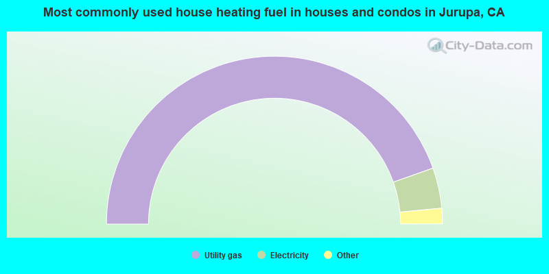
- 89.2%Utility gas
- 7.8%Electricity
- 1.2%Bottled, tank, or LP gas
- 1.0%No fuel used
- 0.7%Wood
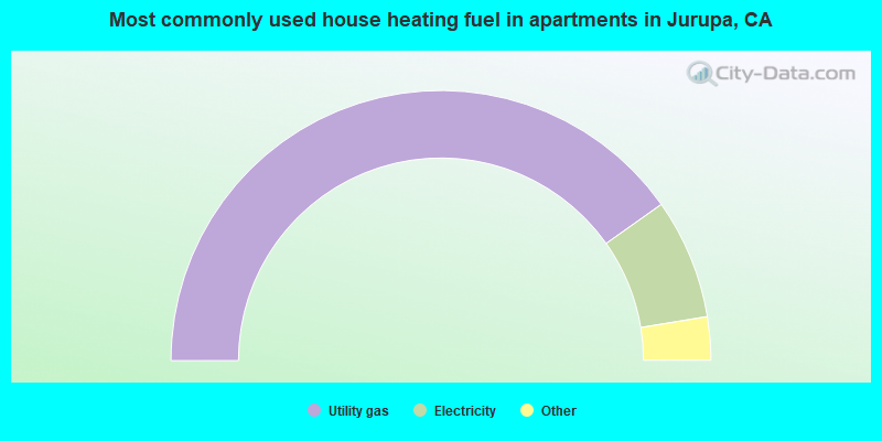
- 80.4%Utility gas
- 14.4%Electricity
- 2.1%Bottled, tank, or LP gas
- 2.0%No fuel used
- 1.0%Wood
- 0.1%Other fuel
Jurupa compared to California state average:
- Unemployed percentage below state average.
- Foreign-born population percentage significantly below state average.
- Renting percentage below state average.
- Length of stay since moving in significantly above state average.
- Number of rooms per house significantly below state average.
- House age significantly below state average.
- Percentage of population with a bachelor's degree or higher significantly below state average.
Jurupa, CA compared to other similar cities:
Jurupa on our top lists:
- #1 on the list of "Top 101 cities with largest percentage of females in industries: wood products (population 50,000+)"
- #1 on the list of "Top 101 cities with largest percentage of males in occupations: material moving workers except supervisors and laborers and material movers, hand (population 50,000+)"
- #1 on the list of "Top 101 cities with largest percentage of females in industries: furniture and related product manufacturing (population 50,000+)"
- #1 on the list of "Top 101 cities with largest percentage of females in industries: furniture and home furnishing merchant wholesalers (population 50,000+)"
- #1 on the list of "Top 101 cities with largest percentage of females in industries: warehousing and storage (population 50,000+)"
- #1 on the list of "Top 101 cities with largest percentage of males in industries: warehousing and storage (population 50,000+)"
- #1 on the list of "Top 101 cities with largest percentage of males in industries: truck transportation (population 50,000+)"
- #1 on the list of "Top 101 cities with largest percentage of females in occupations: other production occupations including supervisors (population 50,000+)"
- #2 on the list of "Top 101 cities with largest percentage of females in industries: plastics and rubber products (population 50,000+)"
- #2 on the list of "Top 101 cities with largest percentage of females in industries: motor vehicles, parts and supplies merchant wholesalers (population 50,000+)"
- #2 on the list of "Top 101 cities with largest percentage of males in industries: metal and metal products (population 50,000+)"
- #2 on the list of "Top 101 cities with largest percentage of males in occupations: driver/sales workers and truck drivers (population 50,000+)"
- #2 on the list of "Top 101 cities with largest percentage of females in industries: hardware, plumbing and heating equipment, and supplies merchant wholesalers (population 50,000+)"
- #3 on the list of "Top 101 cities with largest percentage of females in occupations: laborers and material movers, hand (population 50,000+)"
- #3 on the list of "Top 101 cities with largest percentage of females in occupations: assemblers and fabricators (population 50,000+)"
- #3 on the list of "Top 100 low-educated but high-earning cities (pop. 50,000+)"
- #3 on the list of "Top 101 cities with largest percentage of females in occupations: metal workers and plastic workers (population 50,000+)"
- #3 on the list of "Top 101 cities with largest percentage of males in industries: recyclable material merchant wholesalers (population 50,000+)"
- #4 on the list of "Top 101 cities with the highest percentage of family households, population 100,000+"
- #4 on the list of "Top 101 cities with largest percentage of males in industries: repair and maintenance (population 50,000+)"
- #3 on the list of "Top 101 counties with the highest lead air pollution readings in 2012 (µg/m3)"
- #4 on the list of "Top 101 counties with the highest ground withdrawal of fresh water for public supply"
- #11 on the list of "Top 101 counties with the most Catholic adherents"
- #11 on the list of "Top 101 counties with the highest total withdrawal of fresh water for public supply"
- #12 on the list of "Top 101 counties with the highest carbon monoxide air pollution readings in 2012 (ppm)"