New Salem, Massachusetts
Submit your own pictures of this town and show them to the world
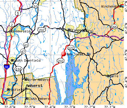
- OSM Map
- General Map
- Google Map
- MSN Map
Population change since 2000: +6.6%
 |
| Males: 499 | |
| Females: 491 |
| Median resident age: | 46.9 years |
| Massachusetts median age: | 39.2 years |
Zip codes: 01355.
| New Salem: | $83,964 |
| MA: | $94,488 |
Estimated per capita income in 2022: $42,331 (it was $23,234 in 2000)
New Salem town income, earnings, and wages data
Estimated median house or condo value in 2022: $316,860 (it was $127,500 in 2000)
| New Salem: | $316,860 |
| MA: | $534,700 |
Mean prices in 2022: all housing units: $313,377; detached houses: $324,224; townhouses or other attached units: $284,225; in 2-unit structures: $287,978; in 3-to-4-unit structures: $183,938; in 5-or-more-unit structures: $249,762; mobile homes: $62,200
Detailed information about poverty and poor residents in New Salem, MA


- 94495.4%White alone
- 212.1%Asian alone
- 101.0%Two or more races
- 101.0%Hispanic
- 20.2%American Indian alone
- 20.2%Other race alone
- 10.1%Black alone
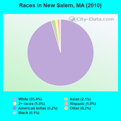
Races in New Salem detailed stats: ancestries, foreign born residents, place of birth
Type |
2009 |
2010 |
2011 |
2012 |
2013 |
|---|---|---|---|---|---|
| Murders (per 100,000) | 0 (0.0) | 0 (0.0) | 0 (0.0) | 0 (0.0) | 0 (0.0) |
| Rapes (per 100,000) | 0 (0.0) | 0 (0.0) | 0 (0.0) | 0 (0.0) | 0 (0.0) |
| Robberies (per 100,000) | 0 (0.0) | 0 (0.0) | 0 (0.0) | 0 (0.0) | 0 (0.0) |
| Assaults (per 100,000) | 1 (99.1) | 0 (0.0) | 0 (0.0) | 0 (0.0) | 1 (99.4) |
| Burglaries (per 100,000) | 2 (198.2) | 1 (101.0) | 0 (0.0) | 4 (398.8) | 1 (99.4) |
| Thefts (per 100,000) | 4 (396.4) | 0 (0.0) | 4 (401.6) | 4 (398.8) | 3 (298.2) |
| Auto thefts (per 100,000) | 0 (0.0) | 1 (101.0) | 0 (0.0) | 0 (0.0) | 0 (0.0) |
| Arson (per 100,000) | 0 (0.0) | 0 (0.0) | 0 (0.0) | 0 (0.0) | 0 (0.0) |
| City-Data.com crime index | 49.6 | 15.2 | 16.1 | 43.9 | 38.8 |
The City-Data.com crime index weighs serious crimes and violent crimes more heavily. Higher means more crime, U.S. average is 246.1. It adjusts for the number of visitors and daily workers commuting into cities.
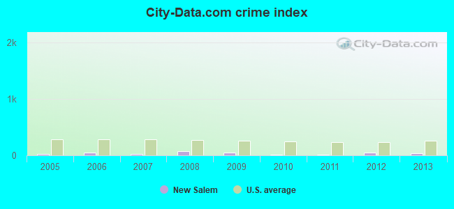
Crime rate in New Salem detailed stats: murders, rapes, robberies, assaults, burglaries, thefts, arson
 Recent articles from our blog. Our writers, many of them Ph.D. graduates or candidates, create easy-to-read articles on a wide variety of topics.

 | Levels of diversity and integration among the towns and cities of Greater Boston (256 replies) |
| Tell me about Pittsfield! (82 replies) |
| Let's talk about the Quabbin Reservoir (25 replies) |
| Which Franklin county town for young family? (12 replies) |
| How Much Massachusetts Households Make Per Year: Census Data (37 replies) |
| Boundaries of MA's regions (63 replies) |
Latest news from New Salem, MA collected exclusively by city-data.com from local newspapers, TV, and radio stations
Ancestries: English (24.5%), Irish (19.2%), French (12.3%), French Canadian (11.8%), German (8.9%), Italian (7.8%).
Current Local Time: EST time zone
Incorporated in 1775
Elevation: 1048 feet
Land area: 45.0 square miles.
Population density: 22 people per square mile (very low).
20 residents are foreign born (0.9% Europe, 0.6% Latin America, 0.3% Asia, 0.3% North America).
| This town: | 2.2% |
| Massachusetts: | 12.2% |
| New Salem town: | 1.3% ($1,601) |
| Massachusetts: | 1.3% ($2,336) |
Nearest city with pop. 50,000+: Chicopee, MA  (25.5 miles , pop. 54,653).
Nearest city with pop. 200,000+: Boston, MA (63.9 miles , pop. 589,141).
Nearest city with pop. 1,000,000+: Bronx, NY (138.6 miles , pop. 1,332,650).
Nearest cities:
), ), )Latitude: 42.48 N, Longitude: 72.32 W
Area code commonly used in this area: 978

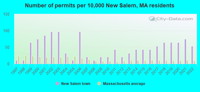
Single-family new house construction building permits:
- 2022: 5 buildings, average cost: $230,000
- 2021: 7 buildings, average cost: $230,000
- 2020: 6 buildings, average cost: $230,000
- 2019: 6 buildings, average cost: $230,000
- 2018: 6 buildings, average cost: $230,000
- 2017: 5 buildings, average cost: $230,000
- 2016: 4 buildings, average cost: $230,000
- 2015: 4 buildings, average cost: $230,000
- 2014: 4 buildings, average cost: $230,000
- 2013: 3 buildings, average cost: $230,000
- 2012: 2 buildings, average cost: $230,000
- 2011: 4 buildings, average cost: $230,000
- 2010: 2 buildings, average cost: $230,000
- 2009: 2 buildings, average cost: $230,000
- 2008: 1 building, cost: $230,000
- 2007: 2 buildings, average cost: $125,000
- 2006: 9 buildings, average cost: $175,100
- 2005: 1 building, cost: $138,800
- 2004: 3 buildings, average cost: $138,800
- 2003: 9 buildings, average cost: $117,700
- 2002: 9 buildings, average cost: $117,700
- 2001: 8 buildings, average cost: $117,700
- 2000: 7 buildings, average cost: $117,700
- 1999: 6 buildings, average cost: $117,700
- 1998: 1 building, cost: $85,000
- 1997: 1 building, cost: $85,000

| Here: | 2.4% |
| Massachusetts: | 3.5% |
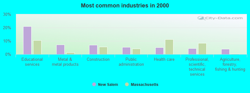
- Educational services (20.9%)
- Metal & metal products (7.2%)
- Construction (7.0%)
- Public administration (5.5%)
- Health care (5.1%)
- Professional, scientific, technical services (4.5%)
- Agriculture, forestry, fishing & hunting (4.0%)
- Educational services (12.4%)
- Construction (11.7%)
- Metal & metal products (10.4%)
- Agriculture, forestry, fishing & hunting (6.4%)
- Public administration (6.4%)
- Professional, scientific, technical services (4.0%)
- Department & other general merchandise stores (3.7%)
- Educational services (31.8%)
- Health care (9.0%)
- Social assistance (6.4%)
- Professional, scientific, technical services (5.2%)
- Public administration (4.3%)
- Accommodation & food services (4.3%)
- Finance & insurance (3.9%)
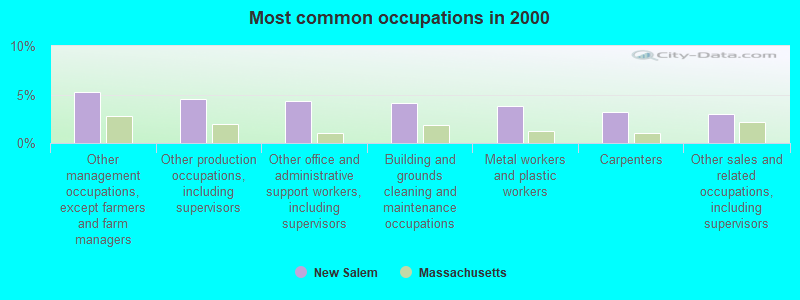
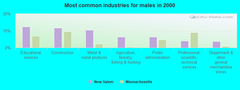
- Other management occupations, except farmers and farm managers (5.3%)
- Other production occupations, including supervisors (4.5%)
- Other office and administrative support workers, including supervisors (4.3%)
- Building and grounds cleaning and maintenance occupations (4.1%)
- Metal workers and plastic workers (3.8%)
- Carpenters (3.2%)
- Other sales and related occupations, including supervisors (3.0%)
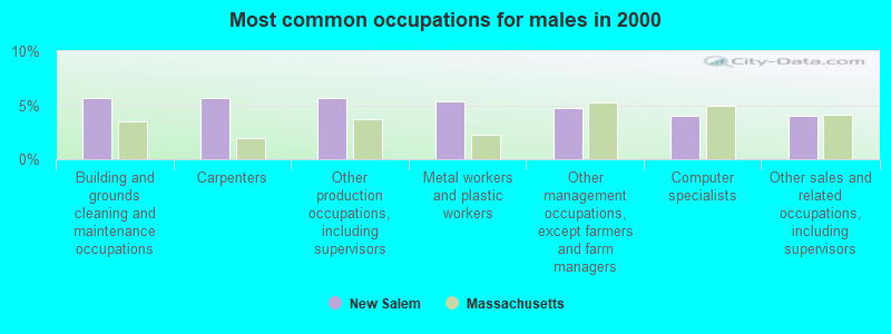
- Building and grounds cleaning and maintenance occupations (5.7%)
- Carpenters (5.7%)
- Other production occupations, including supervisors (5.7%)
- Metal workers and plastic workers (5.4%)
- Other management occupations, except farmers and farm managers (4.7%)
- Computer specialists (4.0%)
- Other sales and related occupations, including supervisors (4.0%)
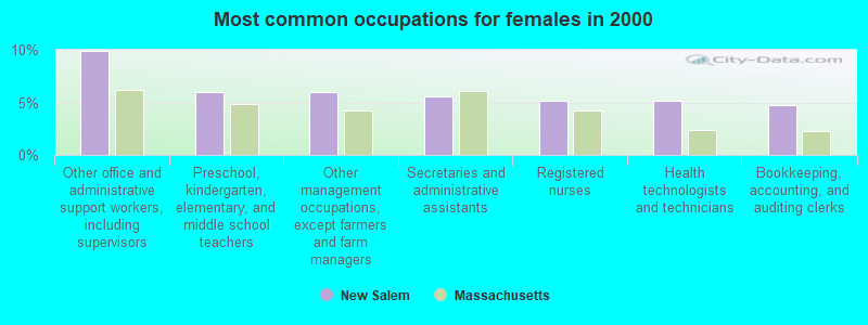
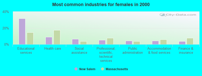
- Other office and administrative support workers, including supervisors (9.9%)
- Preschool, kindergarten, elementary, and middle school teachers (6.0%)
- Other management occupations, except farmers and farm managers (6.0%)
- Secretaries and administrative assistants (5.6%)
- Registered nurses (5.2%)
- Health technologists and technicians (5.2%)
- Bookkeeping, accounting, and auditing clerks (4.7%)
Average climate in New Salem, Massachusetts
Based on data reported by over 4,000 weather stations


(lower is better)
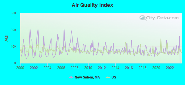
Air Quality Index (AQI) level in 2022 was 73.1. This is about average.
| City: | 73.1 |
| U.S.: | 72.6 |
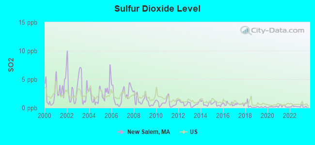
Sulfur Dioxide (SO2) [ppb] level in 2022 was 0.216. This is significantly better than average. Closest monitor was 9.0 miles away from the city center.
| City: | 0.216 |
| U.S.: | 1.515 |
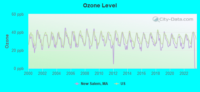
Ozone [ppb] level in 2022 was 29.6. This is about average. Closest monitor was 11.7 miles away from the city center.
| City: | 29.6 |
| U.S.: | 33.3 |

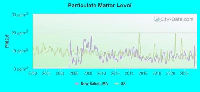
Particulate Matter (PM2.5) [µg/m3] level in 2022 was 6.78. This is about average. Closest monitor was 12.6 miles away from the city center.
| City: | 6.78 |
| U.S.: | 8.11 |
Tornado activity:
New Salem-area historical tornado activity is above Massachusetts state average. It is 10% smaller than the overall U.S. average.
On 6/9/1953, a category F4 (max. wind speeds 207-260 mph) tornado 7.7 miles away from the New Salem town center killed 90 people and injured 1228 people and caused between $50,000,000 and $500,000,000 in damages.
On 10/3/1970, a category F3 (max. wind speeds 158-206 mph) tornado 12.9 miles away from the town center killed one person and caused between $50,000 and $500,000 in damages.
Earthquake activity:
New Salem-area historical earthquake activity is significantly above Massachusetts state average. It is 70% smaller than the overall U.S. average.On 10/7/1983 at 10:18:46, a magnitude 5.3 (5.1 MB, 5.3 LG, 5.1 ML, Class: Moderate, Intensity: VI - VII) earthquake occurred 144.1 miles away from the city center
On 4/20/2002 at 10:50:47, a magnitude 5.3 (5.3 ML, Depth: 3.0 mi) earthquake occurred 156.6 miles away from New Salem center
On 4/20/2002 at 10:50:47, a magnitude 5.2 (5.2 MB, 4.2 MS, 5.2 MW, 5.0 MW) earthquake occurred 155.5 miles away from New Salem center
On 1/19/1982 at 00:14:42, a magnitude 4.7 (4.5 MB, 4.7 MD, 4.5 LG, Class: Light, Intensity: IV - V) earthquake occurred 79.4 miles away from New Salem center
On 10/16/2012 at 23:12:25, a magnitude 4.7 (4.7 ML, Depth: 10.0 mi) earthquake occurred 114.2 miles away from New Salem center
On 10/2/1994 at 11:27:22, a magnitude 3.7 (3.5 LG, 3.7 LG, Depth: 6.2 mi, Class: Light, Intensity: II - III) earthquake occurred 9.5 miles away from the city center
Magnitude types: regional Lg-wave magnitude (LG), body-wave magnitude (MB), duration magnitude (MD), local magnitude (ML), surface-wave magnitude (MS), moment magnitude (MW)
Natural disasters:
The number of natural disasters in Franklin County (20) is greater than the US average (15).Major Disasters (Presidential) Declared: 9
Emergencies Declared: 10
Causes of natural disasters: Floods: 5, Storms: 5, Hurricanes: 4, Snowstorms: 4, Winter Storms: 3, Blizzards: 2, Snows: 2, Snowfall: 1, Tropical Storm: 1, Wind: 1, Other: 1 (Note: some incidents may be assigned to more than one category).
Hospitals and medical centers near New Salem:
- QUABBIN VALLEY HEALTHCARE (Nursing Home, about 7 miles away; ATHOL, MA)
- ATHOL MEMORIAL HOME HEALTH AND HOSPICE (Hospital, about 10 miles away; ATHOL, MA)
- ATHOL MEMORIAL HOSPITAL Critical Access Hospitals (about 10 miles away; ATHOL, MA)
- HOSPICE OF THE FISHER HOME (Hospital, about 12 miles away; AMHERST, MA)
- TEMPLETON DEVELOPMENTAL CENTER (Hospital, about 14 miles away; BALDWINVILLE, MA)
- CENTER FOR EXTENDED CARE AT AMHERST (Nursing Home, about 14 miles away; AMHERST, MA)
- COZY CORNER NURSING AND REHABILITATION CENTER (Nursing Home, about 14 miles away; SUNDERLAND, MA)
Colleges/universities with over 2000 students nearest to New Salem:
- University of Massachusetts-Amherst (about 13 miles; Amherst, MA; Full-time enrollment: 26,583)
- Mount Wachusett Community College (about 19 miles; Gardner, MA; FT enrollment: 3,143)
- Smith College (about 20 miles; Northampton, MA; FT enrollment: 3,549)
- Mount Holyoke College (about 21 miles; South Hadley, MA; FT enrollment: 2,573)
- Franklin Pierce University (about 25 miles; Rindge, NH; FT enrollment: 2,139)
- Holyoke Community College (about 26 miles; Holyoke, MA; FT enrollment: 4,911)
- Western New England University (about 28 miles; Springfield, MA; FT enrollment: 3,477)
Public elementary/middle school in New Salem:
- SWIFT RIVER (Students: 159, Location: 201 WENDELL RD, Grades: PK-6)
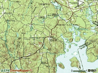
Points of interest:
Notable locations in New Salem: Hamilton Orchards (A), New Salem Fire Department (B), New Salem Public Library (C). Display/hide their locations on the map
Churches in New Salem include: North Congregational Church (A), Central Congregational Church (B). Display/hide their locations on the map
Cemeteries: Mountain View Cemetery (1), Branch Cemetery (2). Display/hide their locations on the map
Lakes and swamps: Thompson Pond (A), Russ Pond (B), Nance Lake (C), Hackmetack Pond (D), Gibbs Pond (E), Flask Pond (F), Dead Pond (G), Davis Pond (H). Display/hide their locations on the map
Streams, rivers, and creeks: Underhill Brook (A), Bow Brook (B), Giles Brook (C), Hop Brook (D), Manning Brook (E), McIver Brook (F), Moosehorn Brook (G), Spriggy Brook (H), Willow Brook (I). Display/hide their locations on the map
Park in New Salem: New Salem Common Historic District (1). Display/hide its location on the map
Birthplace of: Elisha Hunt Allen - Politician, Joshua Mason Macomber - Educator.
| This town: | 2.5 people |
| Massachusetts: | 2.5 people |
| This town: | 69.3% |
| Whole state: | 63.0% |
| This town: | 8.9% |
| Whole state: | 7.0% |
Likely homosexual households (counted as self-reported same-sex unmarried-partner households)
- Lesbian couples: 0.7% of all households
- Gay men: 0.7% of all households
| This town: | 6.3% |
| Whole state: | 9.3% |
| This town: | 2.5% |
| Whole state: | 4.4% |
For population 15 years and over in New Salem:
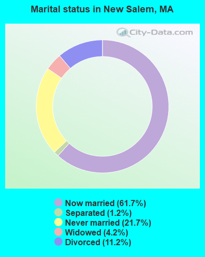
- Never married: 21.7%
- Now married: 61.7%
- Separated: 1.2%
- Widowed: 4.2%
- Divorced: 11.2%
For population 25 years and over in New Salem:
- High school or higher: 92.0%
- Bachelor's degree or higher: 39.5%
- Graduate or professional degree: 15.0%
- Unemployed: 4.0%
- Mean travel time to work (commute): 32.2 minutes

| Here: | 10.7 |
| Massachusetts average: | 13.1 |


Graphs represent county-level data. Detailed 2008 Election Results
Religion statistics for New Salem, MA (based on Franklin County data)


| Religion | Adherents | Congregations |
|---|---|---|
| Catholic | 16,509 | 15 |
| Mainline Protestant | 4,617 | 38 |
| Evangelical Protestant | 2,079 | 20 |
| Other | 1,580 | 21 |
| None | 46,587 | - |
Food Environment Statistics:
| This county: | 3.63 / 10,000 pop. |
| State: | 1.98 / 10,000 pop. |
| Franklin County: | 0.14 / 10,000 pop. |
| Massachusetts: | 0.05 / 10,000 pop. |
| This county: | 1.67 / 10,000 pop. |
| Massachusetts: | 2.22 / 10,000 pop. |
| This county: | 3.21 / 10,000 pop. |
| Massachusetts: | 1.77 / 10,000 pop. |
| Here: | 8.10 / 10,000 pop. |
| Massachusetts: | 8.76 / 10,000 pop. |
| Here: | 7.5% |
| State: | 8.1% |
| Franklin County: | 22.2% |
| Massachusetts: | 22.5% |
| Franklin County: | 15.1% |
| Massachusetts: | 16.5% |
Strongest AM radio stations in New Salem:
- WCRN (830 AM; 50 kW; WORCESTER, MA; Owner: CARTER BROADCASTING CORPORATION)
- WNNZ (640 AM; 50 kW; WESTFIELD, MA; Owner: CLEAR CHANNEL BROADCASTING LICENSES, INC.)
- WVNE (760 AM; daytime; 25 kW; LEICESTER, MA; Owner: BLOUNT MASSCOM, INC.)
- WCAT (700 AM; daytime; 2 kW; ORANGE-ATHOL, MA; Owner: CITADEL BROADCASTING COMPANY)
- WPNI (1430 AM; 5 kW; AMHERST, MA; Owner: WESTERN MASSACHUSETTS RADIO COMPANY)
- WIZZ (1520 AM; daytime; 10 kW; GREENFIELD, MA; Owner: P. & M. RADIO, LLC)
- WRKO (680 AM; 50 kW; BOSTON, MA; Owner: ENTERCOM BOSTON LICENSE, LLC)
- WKOX (1200 AM; 50 kW; FRAMINGHAM, MA; Owner: CAPSTAR TX LIMITED PARTNERSHIP)
- WEEI (850 AM; 50 kW; BOSTON, MA; Owner: ENTERCOM BOSTON LICENSE, LLC)
- WALE (990 AM; 50 kW; GREENVILLE, RI; Owner: NORTH AMERICAN BROADCASTING CO., INC.)
- WBIX (1060 AM; 40 kW; NATICK, MA; Owner: LANGER BROADCASTING CORPORATION)
- WTIC (1080 AM; 50 kW; HARTFORD, CT; Owner: INFINITY RADIO OPERATIONS INC.)
- WARE (1250 AM; 5 kW; WARE, MA; Owner: SUCCESS SIGNAL BROADCASTING, INC.)
Strongest FM radio stations in New Salem:
- WFCR (88.5 FM; AMHERST, MA; Owner: UNIVERSITY OF MASSACHUSETTS)
- WAMH (89.3 FM; AMHERST, MA; Owner: TRUSTEES OF AMHERST COLLEGE)
- W246AM (97.1 FM; AMHERST, MA; Owner: GREAT NORTHERN RADIO, LLC)
- WAHL (99.9 FM; ATHOL, MA; Owner: CITADEL BROADCASTING COMPANY)
- WAAF (107.3 FM; WORCESTER, MA; Owner: ENTERCOM BOSTON LICENSE, LLC)
- WJDF (97.3 FM; ORANGE, MA; Owner: DEANE BROTHERS BROADCASTING CORP.)
- WHYN-FM (93.1 FM; SPRINGFIELD, MA; Owner: CLEAR CHANNEL BROADCASTING LICENSES, INC.)
- WPVQ (95.3 FM; GREENFIELD, MA; Owner: GREAT NORTHERN RADIO, L.L.C.)
- WRNX (100.9 FM; AMHERST, MA; Owner: WESTERN MASSACHUSETTS RADIO COMPANY)
- WAMC-FM (90.3 FM; ALBANY, NY; Owner: WAMC)
- WFEX (92.1 FM; PETERBOROUGH, NH; Owner: FNX BROADCASTING OF NEW HAMPSHIRE LLC)
- WSRS (96.1 FM; WORCESTER, MA; Owner: CAPSTAR TX LIMITED PARTNERSHIP)
- WYRY (104.9 FM; HINSDALE, NH; Owner: TRI-VALLEY BROADCASTING CORPORATION)
- WHAI (98.3 FM; GREENFIELD, MA; Owner: SAGA COMMUNICATIONS OF NEW ENGLAND, LLC)
- WEQX (102.7 FM; MANCHESTER, VT; Owner: NORTHSHIRE COMMUNICATIONS, INC.)
- WJAN (95.1 FM; SUNDERLAND, VT; Owner: 6 JOHNSON ROAD LICENSES, INC.)
- WVAY (100.7 FM; WILMINGTON, VT; Owner: GREAT NORTHERN RADIO, L.L.C.)
- WXLO (104.5 FM; FITCHBURG, MA; Owner: CITADEL BROADCASTING COMPANY)
- WGAJ (91.7 FM; DEERFIELD, MA; Owner: TRUATEES OF DEERFIELD ACADEMY)
- WHDQ (106.1 FM; CLAREMONT, NH; Owner: GREAT NORTHERN RADIO, L.L.C.)
TV broadcast stations around New Salem:
- WYDN (Channel 48; WORCESTER, MA; Owner: EDUCATIONAL PUBLIC TV CORPORATION)
- WUNI (Channel 27; WORCESTER, MA; Owner: ENTRAVISION HOLDINGS, LLC)
- WUTF (Channel 66; MARLBOROUGH, MA; Owner: TELEFUTURA BOSTON LLC)
New Salem fatal accident list:
Dec 7, 2012 01:20 PM, Us-202, Lat: 77.777700, Lon: 777.777700, Vehicles: 1, Persons: 1, Fatalities: 1
Aug 1, 2009 03:07 PM, Us-202, Lat: 42.490453, Lon: -72.341367, Vehicles: 3, Persons: 5, Fatalities: 1
Dec 8, 2007 06:13 PM, Us-202, Lat: 42.537144, Lon: -72.305403, Vehicles: 3, Persons: 5, Fatalities: 1, Drunk persons involved: 1
Feb 17, 2002 08:41 AM, Us-202, Vehicles: 2, Persons: 3, Fatalities: 1
Sep 13, 1996 08:45 AM, Rte 202, Vehicles: 2, Persons: 2, Fatalities: 1
- National Bridge Inventory (NBI) Statistics
- 2Number of bridges
- 7ft / 2.1mTotal length
- $1,393,000Total costs
- 388Total average daily traffic
- 771Total future (year 2032) average daily traffic
FCC Registered Antenna Towers:
10 (See the full list of FCC Registered Antenna Towers in New Salem)FCC Registered Broadcast Land Mobile Towers:
2- Quabbin Fishing Area 2 (Lat: 42.525083 Lon: -72.291194), Call Sign: WNJU334,
Assigned Frequencies: 151.430 MHz, 159.435 MHz, Grant Date: 05/03/2022, Expiration Date: 07/23/2032, Registrant: Dept. Of Conservation And Recreation, 180 Beaman St, West Boylston, MA 01583, Phone: (508) 792-7806, Fax: (508) 792-7805, Email:
- NEW SALEM, 38 Blueberry Hill Rd. (Ma13726-A) (Lat: 42.506194 Lon: -72.344417), Type: Tower, Structure height: 57.9 m, Overall height: 60.7 m, Call Sign: WQMN331,
Assigned Frequencies: 452.600 MHz, Grant Date: 07/14/2020, Expiration Date: 09/29/2030, Certifier: Gary Cromack, Registrant: Cromack Industries, Greenfield, MA 01302, Phone: (413) 774-6500, Fax: (413) 223-8010, Email:
FCC Registered Microwave Towers:
7- Quabbin, MA, Prescott Peninsula, Quabbin Observatory (Lat: 42.391944 Lon: -72.344611), Type: Tower, Structure height: 20.7 m, Call Sign: WPYG610,
Assigned Frequencies: 23575.0 MHz, Grant Date: 08/07/2003, Expiration Date: 08/07/2013, Cancellation Date: 10/12/2013, Certifier: Paul Luippold, Registrant: Consolidated Spectrum Services, 22 Merrill Drive, Atkinson, NH 03811, Phone: (603) 362-5977, Fax: (603) 362-5977, Email:
- NEW SALEM, End Of Blueberry Hill Rd (Lat: 42.506194 Lon: -72.344417), Type: Pole, Structure height: 57.9 m, Call Sign: WQHH582,
Assigned Frequencies: 11115.0 MHz, 11115.0 MHz, 10551.2 MHz, 10566.2 MHz, Grant Date: 05/13/2017, Expiration Date: 07/30/2027, Certifier: Linda Dunlavy, Registrant: Franklin Regional Council Of Governments, 12 Olive St Ste 2, Greenfield, MA 01301-3351, Phone: (413) 774-3167, Fax: (413) 774-3169, Email:
- BS33XC088, 38 Blueberry Hill Rd. (Ma13726-A) (Lat: 42.506194 Lon: -72.344417), Type: Mtower, Structure height: 57.9 m, Overall height: 60.7 m, Call Sign: WQPU385,
Assigned Frequencies: 10815.0 MHz, 10815.0 MHz, 10815.0 MHz, Grant Date: 08/16/2012, Expiration Date: 08/16/2022, Cancellation Date: 04/06/2022, Certifier: David Werblow, Registrant: Dla Piper LLP, 500 8th Street, Nw, Washington, DC 20004, Phone: (202) 799-4216, Fax: (202) 799-5616, Email:
- CT33XC597, 675 Daniel Shays Highway (Lat: 42.469667 Lon: -72.349528), Type: Pole, Structure height: 46.9 m, Call Sign: WQPU559,
Assigned Frequencies: 11305.0 MHz, 11305.0 MHz, 11305.0 MHz, Grant Date: 08/17/2012, Expiration Date: 08/17/2022, Cancellation Date: 04/06/2022, Certifier: David Werblow, Registrant: Dla Piper LLP, 500 8th Street, Nw, Washington, DC 20004, Phone: (202) 799-4216, Fax: (202) 799-5616, Email:
- New Salem BB, 38 Blueberry Hill Rd. (Ma13726-A) (Lat: 42.506194 Lon: -72.344417), Type: Mtower, Structure height: 57.9 m, Overall height: 60.7 m, Call Sign: WRPQ564,
Assigned Frequencies: 10895.0 MHz, Grant Date: 03/07/2022, Expiration Date: 03/07/2032, Certifier: Cecil J Mathew, Registrant: At&t Services, Inc., 208 S Akard St, 20f, Dallas, TX 75202, Phone: (855) 699-7073, Email:
- NEW SALEM-BLUEBERRY, 38 Blueberry Hill Rd. (Ma13726-A) (Lat: 42.506194 Lon: -72.344417), Type: Mtower, Structure height: 57.9 m, Overall height: 60.7 m, Call Sign: WSBR928,
Assigned Frequencies: 6375.14 MHz, Grant Date: 03/07/2024, Expiration Date: 03/07/2034, Certifier: Matthew M Barstow, Registrant: Massachusetts, Commonwealth Of, 470 Worcester Rd, Framingham, MA 01702, Phone: (508) 820-2264, Email:
- STATION, Prescott Peninsula Quabbin Observatory (Lat: 42.392028 Lon: -72.344528), Structure height: 19.8 m, Overall height: 20.7 m, Call Sign: WEH304,
Assigned Frequencies: 23575.0 MHz, Grant Date: 07/31/1997, Expiration Date: 11/10/2002, Cancellation Date: 02/09/2003, Phone: (413) 545-3123
FCC Registered Amateur Radio Licenses:
7- Call Sign: N1LAY, Licensee ID: L00413487, Grant Date: 01/12/2012, Expiration Date: 01/21/2022, Cancellation Date: 01/23/2024, Certifier: Roderick A Raubeson, Registrant: Roderick A Raubeson, 16 Cooleyville Rd, New Salem, MA 01355
- Call Sign: WB1FBV, Licensee ID: L01215295, Grant Date: 12/08/2016, Expiration Date: 02/17/2027, Certifier: Dale R Monette, Registrant: Dale R Monette, 111 Wendell Road, New Salem, MA 01355
- Call Sign: KC1CLW, Licensee ID: L01890161, Grant Date: 09/03/2014, Expiration Date: 09/03/2024, Cancellation Date: 10/21/2014, Certifier: Russell F Pasternak, Registrant: Russell F Pasternak, 99 Michael Ln, New Salem, MA 01355
- Call Sign: N1TOC, Previous Call Sign: KC1CLW, Licensee ID: L01890161, Grant Date: 10/21/2014, Expiration Date: 10/21/2024, Certifier: Russell F Pasternak, Registrant: Russell F Pasternak, 99 Michael Ln, New Salem, MA 01355
- Call Sign: KC1IJN, Licensee ID: L00637930, Grant Date: 10/26/2017, Expiration Date: 10/26/2027, Certifier: Mark J Wasielewski, Registrant: Mark J Wasielewski, 223 N Main St, New Salem, MA 01355
- Call Sign: KC1JAL, Licensee ID: L02163355, Grant Date: 02/15/2018, Expiration Date: 02/15/2028, Certifier: Owne D Gauthier, Registrant: Owne D Gauthier, 114 S Main St, New Salem, MA 01355
- Call Sign: KC1SCZ, Licensee ID: L02580180, Grant Date: 11/23/2022, Expiration Date: 11/23/2032, Certifier: Andrew J Drawec, Registrant: Andrew J Drawec, 309 Petersham Rd, New Salem, MA 01355
FAA Registered Aircraft Manufacturers and Dealers:
1- CULVER HARRY A, 49 Stone Hill Rd, New Salem, MA 01355
Certificate: 99-0393 (Individual), Certificate Issue Date: 03/04/1999, Expiration Date: 03/03/2000
FAA Registered Aircraft:
2- Aircraft: PIPER PA-32-260 (Category: Land, Seats: 6, Weight: Up to 12,499 Pounds, Speed: 126 mph), Engine: LYCOMING 0-540 SERIES (250 HP) (Reciprocating)
N-Number: 3909W, N3909W, N-3909W, Serial Number: 32-855, Year manufactured: 1967, Airworthiness Date: 03/22/1967, Certificate Issue Date: 03/22/2017
Registrant (Individual): Jefferson J Lett, 38 Blueberry Hill Rd, New Salem, MA 01355 - Aircraft: CESSNA 150M (Category: Land, Seats: 2, Weight: Up to 12,499 Pounds, Speed: 81 mph), Engine: CONT MOTOR 0-200 SERIES (100 HP) (4 Cycle)
N-Number: 9279U, N9279U, N-9279U, Serial Number: 15078229, Year manufactured: 1976, Airworthiness Date: 04/10/1976, Certificate Issue Date: 07/27/2001
Registrant (Individual): Lawrence A Wilson, 27 Sweezy Ln, New Salem, MA 01355
Deregistered: Cancel Date: 06/15/2017
2002 - 2018 National Fire Incident Reporting System (NFIRS) incidents
- Fire incident types reported to NFIRS in New Salem, MA
- 8547.0%Outside Fires
- 7340.3%Structure Fires
- 179.4%Mobile Property/Vehicle Fires
- 63.3%Other
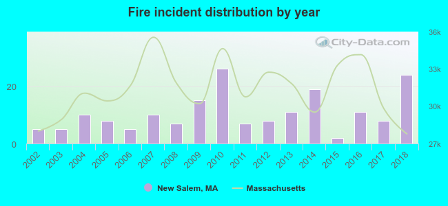 Based on the data from the years 2002 - 2018 the average number of fires per year is 11. The highest number of fire incidents - 26 took place in 2010, and the least - 2 in 2015. The data has a growing trend.
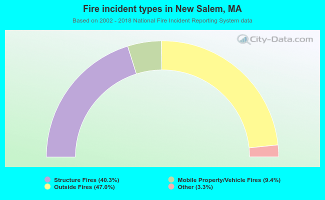 When looking into fire subcategories, the most reports belonged to: Outside Fires (47.0%), and Structure Fires (40.3%).
- 67.8%Fuel oil, kerosene, etc.
- 19.8%Wood
- 6.5%Bottled, tank, or LP gas
- 4.7%Electricity
- 0.6%Utility gas
- 0.6%Solar energy
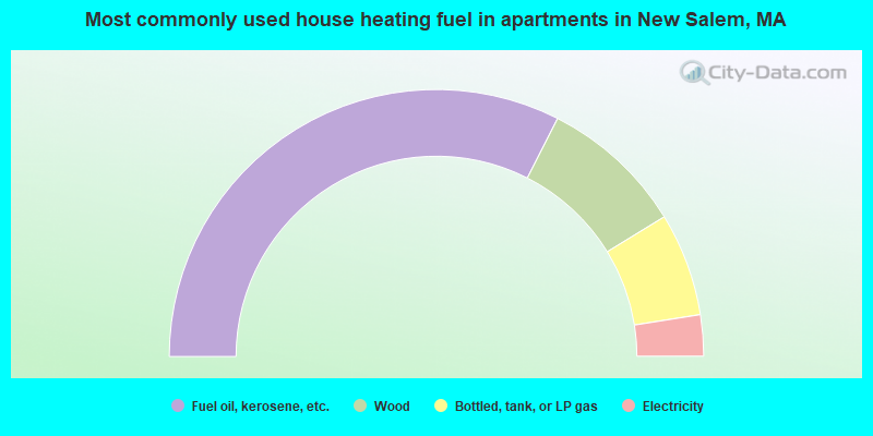
- 65.0%Fuel oil, kerosene, etc.
- 17.5%Wood
- 12.5%Bottled, tank, or LP gas
- 5.0%Electricity
New Salem compared to Massachusetts state average:
- Median house value below state average.
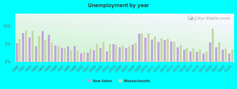
- Unemployed percentage significantly below state average.
- Black race population percentage significantly below state average.
- Hispanic race population percentage significantly below state average.
- Median age above state average.
- Foreign-born population percentage significantly below state average.
- Renting percentage significantly below state average.
- Length of stay since moving in significantly above state average.
- Number of rooms per house significantly below state average.
- House age significantly below state average.

|
Total of 7 patent applications in 2008-2024.