Wendell, Massachusetts
Submit your own pictures of this town and show them to the world
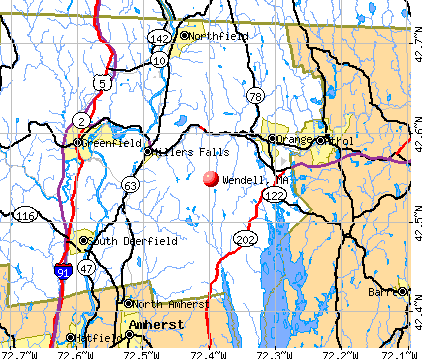
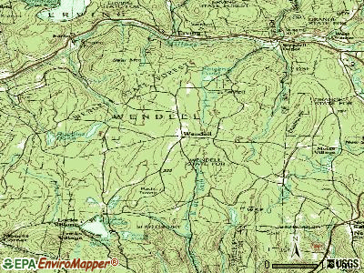
- OSM Map
- General Map
- Google Map
- MSN Map
Population change since 2000: -14.0%
 |
| Males: 421 | |
| Females: 427 |
| Median resident age: | 47.8 years |
| Massachusetts median age: | 39.2 years |
Zip codes: 01379.
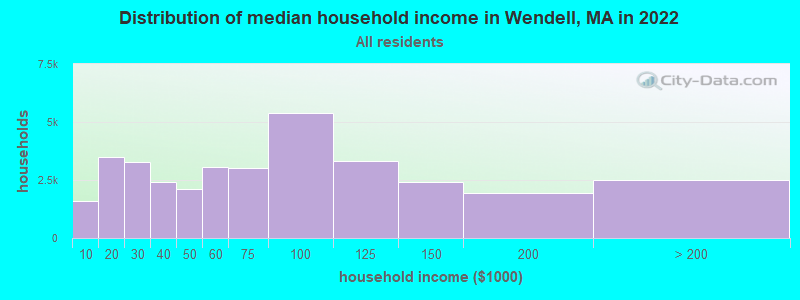
| Wendell: | $75,614 |
| MA: | $94,488 |
Estimated per capita income in 2022: $35,894 (it was $19,701 in 2000)
Wendell town income, earnings, and wages data
Estimated median house or condo value in 2022: $261,192 (it was $105,100 in 2000)
| Wendell: | $261,192 |
| MA: | $534,700 |
Mean prices in 2022: all housing units: $313,377; detached houses: $324,224; townhouses or other attached units: $284,225; in 2-unit structures: $287,978; in 3-to-4-unit structures: $183,938; in 5-or-more-unit structures: $249,762; mobile homes: $62,200
Detailed information about poverty and poor residents in Wendell, MA


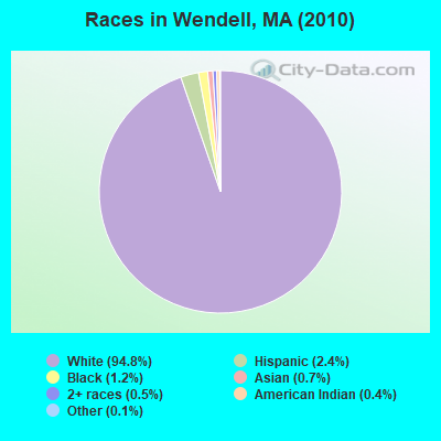
- 80494.8%White alone
- 202.4%Hispanic
- 101.2%Black alone
- 60.7%Asian alone
- 40.5%Two or more races
- 30.4%American Indian alone
- 10.1%Other race alone
Races in Wendell detailed stats: ancestries, foreign born residents, place of birth
According to our research of Massachusetts and other state lists, there were 2 registered sex offenders living in Wendell, Massachusetts as of May 15, 2024.
The ratio of all residents to sex offenders in Wendell is 424 to 1.
 Recent articles from our blog. Our writers, many of them Ph.D. graduates or candidates, create easy-to-read articles on a wide variety of topics.


 | Quincy to open "migrant" shelter in Wollaston (251 replies) |
| 2023 Real Estate Observations (5278 replies) |
| Coronavirus in Massachusetts (18048 replies) |
| MA to NC, are we crazy to even consider it (133 replies) |
| Is it possible to escape hunters, ATVs and noise in a rural area? (278 replies) |
| Dream Boston home, where would you live? (51 replies) |
Latest news from Wendell, MA collected exclusively by city-data.com from local newspapers, TV, and radio stations
Ancestries: English (16.6%), Irish (15.3%), German (11.2%), French (7.7%), Polish (7.7%), United States (7.3%).
Current Local Time: EST time zone
Incorporated in 1781
Elevation: 1164 feet
Land area: 32.0 square miles.
Population density: 27 people per square mile (very low).
15 residents are foreign born
| This town: | 1.5% |
| Massachusetts: | 12.2% |
| Wendell town: | 1.7% ($1,785) |
| Massachusetts: | 1.3% ($2,336) |
Nearest city with pop. 50,000+: Chicopee, MA  (27.9 miles , pop. 54,653).
Nearest city with pop. 200,000+: Boston, MA (68.6 miles , pop. 589,141).
Nearest city with pop. 1,000,000+: Bronx, NY (140.2 miles , pop. 1,332,650).
Nearest cities:
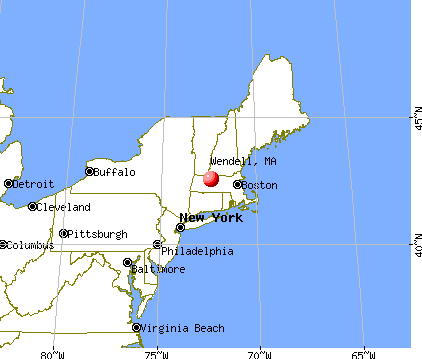
), ), Latitude: 42.55 N, Longitude: 72.40 W

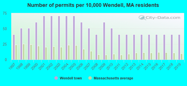
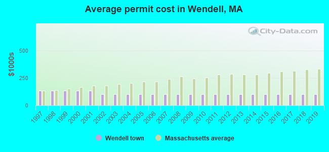
Single-family new house construction building permits:
- 2019: 4 buildings, average cost: $99,900
- 2018: 4 buildings, average cost: $99,900
- 2017: 4 buildings, average cost: $99,900
- 2016: 4 buildings, average cost: $99,900
- 2015: 4 buildings, average cost: $99,900
- 2014: 4 buildings, average cost: $99,900
- 2013: 4 buildings, average cost: $99,900
- 2012: 4 buildings, average cost: $99,900
- 2011: 4 buildings, average cost: $99,900
- 2010: 5 buildings, average cost: $99,900
- 2009: 6 buildings, average cost: $99,900
- 2008: 4 buildings, average cost: $99,900
- 2007: 5 buildings, average cost: $99,900
- 2006: 6 buildings, average cost: $99,900
- 2005: 7 buildings, average cost: $99,900
- 2004: 7 buildings, average cost: $99,900
- 2003: 7 buildings, average cost: $99,900
- 2002: 7 buildings, average cost: $99,900
- 2001: 7 buildings, average cost: $131,500
- 2000: 6 buildings, average cost: $131,500
- 1999: 5 buildings, average cost: $131,500
- 1998: 5 buildings, average cost: $131,500
- 1997: 4 buildings, average cost: $131,500
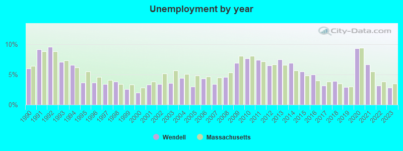
| Here: | 2.8% |
| Massachusetts: | 3.5% |
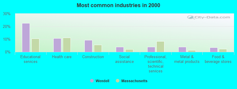
- Educational services (22.6%)
- Health care (10.8%)
- Construction (9.2%)
- Social assistance (3.9%)
- Professional, scientific, technical services (3.9%)
- Metal & metal products (3.9%)
- Food & beverage stores (3.6%)
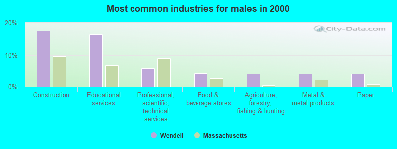
- Construction (17.5%)
- Educational services (16.4%)
- Professional, scientific, technical services (5.8%)
- Food & beverage stores (4.4%)
- Agriculture, forestry, fishing & hunting (4.0%)
- Metal & metal products (4.0%)
- Paper (4.0%)

- Educational services (28.1%)
- Health care (17.7%)
- Social assistance (6.1%)
- Metal & metal products (3.9%)
- Arts, entertainment, recreation (3.9%)
- Accommodation & food services (3.2%)
- Food & beverage stores (2.9%)
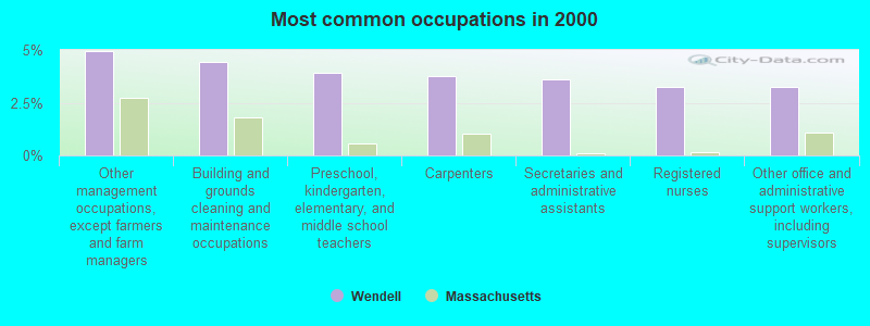
- Other management occupations, except farmers and farm managers (5.0%)
- Building and grounds cleaning and maintenance occupations (4.4%)
- Preschool, kindergarten, elementary, and middle school teachers (3.9%)
- Carpenters (3.8%)
- Secretaries and administrative assistants (3.6%)
- Registered nurses (3.2%)
- Other office and administrative support workers, including supervisors (3.2%)
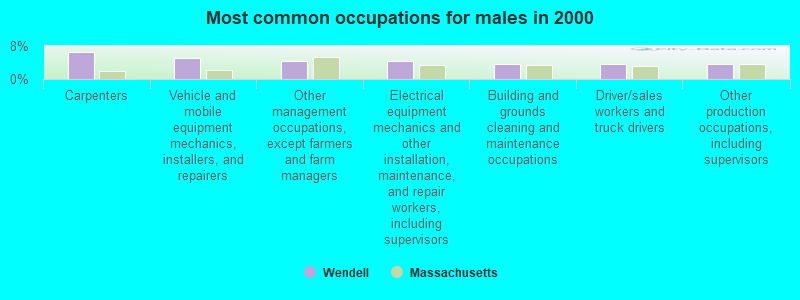
- Carpenters (6.5%)
- Vehicle and mobile equipment mechanics, installers, and repairers (5.1%)
- Other management occupations, except farmers and farm managers (4.4%)
- Electrical equipment mechanics and other installation, maintenance, and repair workers, including supervisors (4.4%)
- Building and grounds cleaning and maintenance occupations (3.6%)
- Driver/sales workers and truck drivers (3.6%)
- Other production occupations, including supervisors (3.6%)
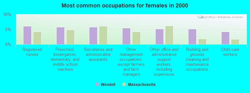
- Registered nurses (6.1%)
- Preschool, kindergarten, elementary, and middle school teachers (5.8%)
- Secretaries and administrative assistants (5.8%)
- Other management occupations, except farmers and farm managers (5.5%)
- Other office and administrative support workers, including supervisors (5.2%)
- Building and grounds cleaning and maintenance occupations (5.2%)
- Child care workers (4.2%)
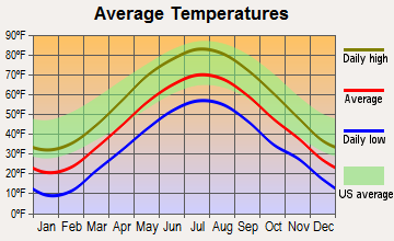
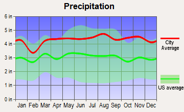
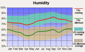
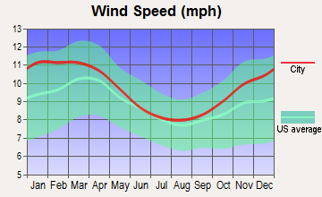
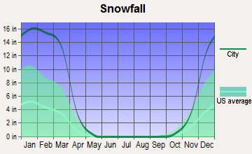
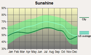
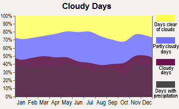
Average climate in Wendell, Massachusetts
Based on data reported by over 4,000 weather stations
(lower is better)
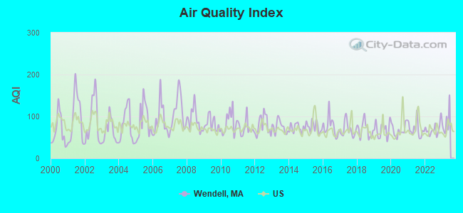
Air Quality Index (AQI) level in 2022 was 69.2. This is about average.
| City: | 69.2 |
| U.S.: | 72.6 |
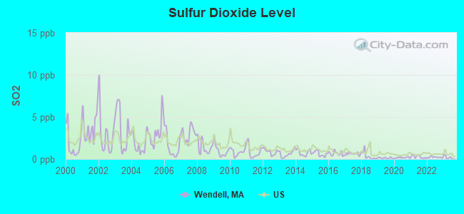
Sulfur Dioxide (SO2) [ppb] level in 2022 was 0.216. This is significantly better than average. Closest monitor was 3.6 miles away from the city center.
| City: | 0.216 |
| U.S.: | 1.515 |
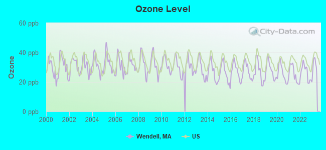
Ozone [ppb] level in 2022 was 26.4. This is better than average. Closest monitor was 6.8 miles away from the city center.
| City: | 26.4 |
| U.S.: | 33.3 |
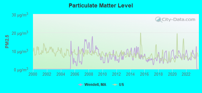
Particulate Matter (PM2.5) [µg/m3] level in 2022 was 7.11. This is about average. Closest monitor was 10.9 miles away from the city center.
| City: | 7.11 |
| U.S.: | 8.11 |
Tornado activity:
Wendell-area historical tornado activity is above Massachusetts state average. It is 11% smaller than the overall U.S. average.
On 6/9/1953, a category F4 (max. wind speeds 207-260 mph) tornado 12.8 miles away from the Wendell town center killed 90 people and injured 1228 people and caused between $50,000,000 and $500,000,000 in damages.
On 10/3/1979, a category F4 tornado 37.8 miles away from the town center killed 3 people and injured 500 people and caused between $50,000,000 and $500,000,000 in damages.
Earthquake activity:
Wendell-area historical earthquake activity is significantly above Massachusetts state average. It is 70% smaller than the overall U.S. average.On 10/7/1983 at 10:18:46, a magnitude 5.3 (5.1 MB, 5.3 LG, 5.1 ML, Class: Moderate, Intensity: VI - VII) earthquake occurred 138.0 miles away from Wendell center
On 4/20/2002 at 10:50:47, a magnitude 5.3 (5.3 ML, Depth: 3.0 mi) earthquake occurred 150.7 miles away from the city center
On 4/20/2002 at 10:50:47, a magnitude 5.2 (5.2 MB, 4.2 MS, 5.2 MW, 5.0 MW) earthquake occurred 149.6 miles away from the city center
On 1/19/1982 at 00:14:42, a magnitude 4.7 (4.5 MB, 4.7 MD, 4.5 LG, Class: Light, Intensity: IV - V) earthquake occurred 77.2 miles away from the city center
On 10/16/2012 at 23:12:25, a magnitude 4.7 (4.7 ML, Depth: 10.0 mi) earthquake occurred 114.0 miles away from Wendell center
On 10/2/1994 at 11:27:22, a magnitude 3.7 (3.5 LG, 3.7 LG, Depth: 6.2 mi, Class: Light, Intensity: II - III) earthquake occurred 15.2 miles away from Wendell center
Magnitude types: regional Lg-wave magnitude (LG), body-wave magnitude (MB), duration magnitude (MD), local magnitude (ML), surface-wave magnitude (MS), moment magnitude (MW)
Natural disasters:
The number of natural disasters in Franklin County (20) is greater than the US average (15).Major Disasters (Presidential) Declared: 9
Emergencies Declared: 10
Causes of natural disasters: Floods: 5, Storms: 5, Hurricanes: 4, Snowstorms: 4, Winter Storms: 3, Blizzards: 2, Snows: 2, Snowfall: 1, Tropical Storm: 1, Wind: 1, Other: 1 (Note: some incidents may be assigned to more than one category).
Hospitals and medical centers near Wendell:
- QUABBIN VALLEY HEALTHCARE (Nursing Home, about 7 miles away; ATHOL, MA)
- ATHOL MEMORIAL HOME HEALTH AND HOSPICE (Hospital, about 10 miles away; ATHOL, MA)
- ATHOL MEMORIAL HOSPITAL Critical Access Hospitals (about 10 miles away; ATHOL, MA)
- NURSE'S HOUSE CALL - GREENFIELD (Home Health Center, about 10 miles away; GREENFIELD, MA)
- YANKEE FAMILY DIALYSIS CENTER (Dialysis Facility, about 11 miles away; GREENFIELD, MA)
- POET'S SEAT HEALTH CARE CENTER (Nursing Home, about 11 miles away; GREENFIELD, MA)
- BAYSTATE FRANKLIN MEDICAL CENTER Acute Care Hospitals (about 11 miles away; GREENFIELD, MA)
Operable nuclear power plant near Wendell:
- 17 miles: Vermont Yankee in Vernon, VT.
Colleges/universities with over 2000 students nearest to Wendell:
- University of Massachusetts-Amherst (about 14 miles; Amherst, MA; Full-time enrollment: 26,583)
- Smith College (about 21 miles; Northampton, MA; FT enrollment: 3,549)
- Mount Wachusett Community College (about 22 miles; Gardner, MA; FT enrollment: 3,143)
- Mount Holyoke College (about 23 miles; South Hadley, MA; FT enrollment: 2,573)
- Franklin Pierce University (about 24 miles; Rindge, NH; FT enrollment: 2,139)
- Keene State College (about 27 miles; Keene, NH; FT enrollment: 5,098)
- Holyoke Community College (about 28 miles; Holyoke, MA; FT enrollment: 4,911)
Points of interest:
Notable locations in Wendell: Wendell Fire Department (A), Wendell Town Hall (B), Erving Town Hall (C). Display/hide their locations on the map
Cemetery: South Cemetery (1). Display/hide its location on the map
Lakes and reservoirs: Tyler Pond (A), Sibley Swamp (B), Wickett Pond (C), Bowens Pond (D), Fiske Pond (E), Ruggles Pond (F), Plympton Brook Reservoir (G). Display/hide their locations on the map
Streams, rivers, and creeks: Wickett Brook (A), Fisher Brook (B), Whetstone Brook (C), Plympton Brook (D), Fiske Brook (E), Baker Brook (F), Briggs Brook (G), Gate Hill Brook (H), Mormon Hollow Brook (I). Display/hide their locations on the map
Birthplace of: James C. Greenough - Educator and college president, Scott Woodward - College football player (Massachusetts Minutemen).
| This town: | 2.2 people |
| Massachusetts: | 2.5 people |
| This town: | 58.3% |
| Whole state: | 63.0% |
| This town: | 14.1% |
| Whole state: | 7.0% |
Likely homosexual households (counted as self-reported same-sex unmarried-partner households)
- Lesbian couples: 2.8% of all households
- Gay men: 0.5% of all households
| This town: | 10.2% |
| Whole state: | 9.3% |
| This town: | 4.3% |
| Whole state: | 4.4% |
50 people in religious group quarters in 2000
48 people in residential treatment centers for emotionally disturbed children in 2000
For population 15 years and over in Wendell:
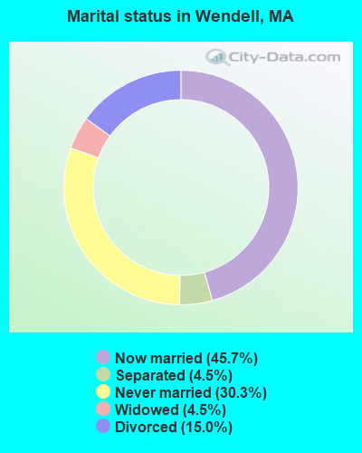
- Never married: 30.3%
- Now married: 45.7%
- Separated: 4.5%
- Widowed: 4.5%
- Divorced: 15.0%
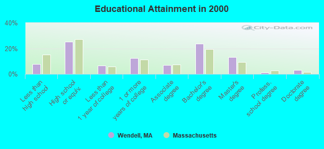
For population 25 years and over in Wendell:
- High school or higher: 92.1%
- Bachelor's degree or higher: 41.1%
- Graduate or professional degree: 17.3%
- Unemployed: 4.7%
- Mean travel time to work (commute): 31.6 minutes
| Here: | 10.8 |
| Massachusetts average: | 13.1 |


Graphs represent county-level data. Detailed 2008 Election Results
Religion statistics for Wendell, MA (based on Franklin County data)


| Religion | Adherents | Congregations |
|---|---|---|
| Catholic | 16,509 | 15 |
| Mainline Protestant | 4,617 | 38 |
| Evangelical Protestant | 2,079 | 20 |
| Other | 1,580 | 21 |
| None | 46,587 | - |
Food Environment Statistics:
| This county: | 3.63 / 10,000 pop. |
| State: | 1.98 / 10,000 pop. |
| Franklin County: | 0.14 / 10,000 pop. |
| Massachusetts: | 0.05 / 10,000 pop. |
| This county: | 1.67 / 10,000 pop. |
| Massachusetts: | 2.22 / 10,000 pop. |
| Franklin County: | 3.21 / 10,000 pop. |
| Massachusetts: | 1.77 / 10,000 pop. |
| Franklin County: | 8.10 / 10,000 pop. |
| Massachusetts: | 8.76 / 10,000 pop. |
| Franklin County: | 7.5% |
| Massachusetts: | 8.1% |
| This county: | 22.2% |
| Massachusetts: | 22.5% |
| This county: | 15.1% |
| Massachusetts: | 16.5% |
Strongest AM radio stations in Wendell:
- WCAT (700 AM; daytime; 2 kW; ORANGE-ATHOL, MA; Owner: CITADEL BROADCASTING COMPANY)
- WNNZ (640 AM; 50 kW; WESTFIELD, MA; Owner: CLEAR CHANNEL BROADCASTING LICENSES, INC.)
- WCRN (830 AM; 50 kW; WORCESTER, MA; Owner: CARTER BROADCASTING CORPORATION)
- WIZZ (1520 AM; daytime; 10 kW; GREENFIELD, MA; Owner: P. & M. RADIO, LLC)
- WVNE (760 AM; daytime; 25 kW; LEICESTER, MA; Owner: BLOUNT MASSCOM, INC.)
- WRKO (680 AM; 50 kW; BOSTON, MA; Owner: ENTERCOM BOSTON LICENSE, LLC)
- WPNI (1430 AM; 5 kW; AMHERST, MA; Owner: WESTERN MASSACHUSETTS RADIO COMPANY)
- WEEI (850 AM; 50 kW; BOSTON, MA; Owner: ENTERCOM BOSTON LICENSE, LLC)
- WKOX (1200 AM; 50 kW; FRAMINGHAM, MA; Owner: CAPSTAR TX LIMITED PARTNERSHIP)
- WALE (990 AM; 50 kW; GREENVILLE, RI; Owner: NORTH AMERICAN BROADCASTING CO., INC.)
- WTIC (1080 AM; 50 kW; HARTFORD, CT; Owner: INFINITY RADIO OPERATIONS INC.)
- WBIX (1060 AM; 40 kW; NATICK, MA; Owner: LANGER BROADCASTING CORPORATION)
- WHYN (560 AM; 5 kW; SPRINGFIELD, MA; Owner: CLEAR CHANNEL BROADCASTING LICENSES, INC.)
Strongest FM radio stations in Wendell:
- WJDF (97.3 FM; ORANGE, MA; Owner: DEANE BROTHERS BROADCASTING CORP.)
- WFCR (88.5 FM; AMHERST, MA; Owner: UNIVERSITY OF MASSACHUSETTS)
- WAMH (89.3 FM; AMHERST, MA; Owner: TRUSTEES OF AMHERST COLLEGE)
- WPVQ (95.3 FM; GREENFIELD, MA; Owner: GREAT NORTHERN RADIO, L.L.C.)
- WHAI (98.3 FM; GREENFIELD, MA; Owner: SAGA COMMUNICATIONS OF NEW ENGLAND, LLC)
- WYRY (104.9 FM; HINSDALE, NH; Owner: TRI-VALLEY BROADCASTING CORPORATION)
- W246AM (97.1 FM; AMHERST, MA; Owner: GREAT NORTHERN RADIO, LLC)
- WAHL (99.9 FM; ATHOL, MA; Owner: CITADEL BROADCASTING COMPANY)
- WAMC-FM (90.3 FM; ALBANY, NY; Owner: WAMC)
- WGAJ (91.7 FM; DEERFIELD, MA; Owner: TRUATEES OF DEERFIELD ACADEMY)
- WHYN-FM (93.1 FM; SPRINGFIELD, MA; Owner: CLEAR CHANNEL BROADCASTING LICENSES, INC.)
- WRSI (93.9 FM; TURNERS FALLS, MA; Owner: GREAT NORTHERN RADIO, LLC)
- WFEX (92.1 FM; PETERBOROUGH, NH; Owner: FNX BROADCASTING OF NEW HAMPSHIRE LLC)
- WRNX (100.9 FM; AMHERST, MA; Owner: WESTERN MASSACHUSETTS RADIO COMPANY)
- WOQL (98.7 FM; WINCHESTER, NH; Owner: SAGA COMMUNICATIONS OF NEW HAMPSHIRE, LLC)
- WEQX (102.7 FM; MANCHESTER, VT; Owner: NORTHSHIRE COMMUNICATIONS, INC.)
- WAAF (107.3 FM; WORCESTER, MA; Owner: ENTERCOM BOSTON LICENSE, LLC)
- WVAY (100.7 FM; WILMINGTON, VT; Owner: GREAT NORTHERN RADIO, L.L.C.)
- WJAN (95.1 FM; SUNDERLAND, VT; Owner: 6 JOHNSON ROAD LICENSES, INC.)
- WRSY (101.5 FM; MARLBORO, VT; Owner: GREAT NORTHERN RADIO, L.L.C.)
TV broadcast stations around Wendell:
- WYDN (Channel 48; WORCESTER, MA; Owner: EDUCATIONAL PUBLIC TV CORPORATION)
- WUNI (Channel 27; WORCESTER, MA; Owner: ENTRAVISION HOLDINGS, LLC)
- WUTF (Channel 66; MARLBOROUGH, MA; Owner: TELEFUTURA BOSTON LLC)
Wendell fatal accident list:
Apr 6, 2002 08:20 PM, Lockes Village Rd, Vehicles: 1, Persons: 3, Fatalities: 1
Nov 11, 1991 12:35 AM, Montagu Rd, Vehicles: 1, Persons: 4, Fatalities: 1
- National Bridge Inventory (NBI) Statistics
- 2Number of bridges
- 16ft / 4.7mTotal length
- $2,876,000Total costs
- 8,367Total average daily traffic
- 266Total average daily truck traffic
FCC Registered Antenna Towers:
8 (See the full list of FCC Registered Antenna Towers in Wendell)FCC Registered Microwave Towers:
1- STATION, Lat: 42.533417 Lon: -72.466194, Overall height: 6.1 m, Call Sign: WNTR640,
Assigned Frequencies: 952.818 MHz, Grant Date: 09/06/2018, Expiration Date: 10/12/2028, Registrant: Utilities Technology Council, 1129 20th Street Nw, Suite 350, Washington, DC 20036, Phone: (202) 872-0030, Fax: (202) 872-1331, Email:
FCC Registered Amateur Radio Licenses:
7- Call Sign: KA1RKI, Licensee ID: L01340369, Grant Date: 08/11/2017, Expiration Date: 11/03/2027, Certifier: Rita E Jean, Registrant: Rita E Jean, 19 Morse Village Rd, Wendell, MA 01379-9704
- Call Sign: KA1RKJ, Licensee ID: L00439681, Grant Date: 08/11/2017, Expiration Date: 11/03/2027, Certifier: Roland L Jean Sr, Registrant: Roland L Jean Sr, 19 Morse Village Rd, Wendell, MA 01379-9704
- Call Sign: N1WGQ, Grant Date: 12/05/1995, Expiration Date: 12/05/2005, Cancellation Date: 12/06/2007, Registrant: John M Davis, 252 New Salem Rd, Wendell, MA 01379
- Call Sign: KB1EUI, Licensee ID: L00202417, Grant Date: 02/01/2000, Expiration Date: 02/01/2010, Cancellation Date: 02/02/2012, Certifier: James D Delaronde, Registrant: James D Delaronde, 39 Old Farley Rd, Wendell, MA 01379
- Call Sign: KB1OOK, Licensee ID: L01252236, Grant Date: 12/30/2016, Expiration Date: 03/02/2027, Certifier: Kathleen O'Kane, Registrant: Kathleen O\'Kane, Wendell, MA 01379
- Call Sign: KK4KYG, Licensee ID: L01727346, Grant Date: 02/24/2023, Expiration Date: 02/24/2033, Certifier: Robert J Mckinney, Registrant: Robert J Mckinney, 146 Montague Road, Wendell, MA 01379
- Call Sign: KC1KKY, Licensee ID: L02221853, Grant Date: 10/25/2018, Expiration Date: 10/25/2028, Certifier: Asa Q De Roode, Registrant: Asa Q De Roode, Wendell, MA 01379-0932
2002 - 2018 National Fire Incident Reporting System (NFIRS) incidents
- Fire incident types reported to NFIRS in Wendell, MA
- 6250.4%Structure Fires
- 4839.0%Outside Fires
- 97.3%Mobile Property/Vehicle Fires
- 43.3%Other
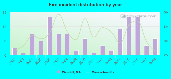 According to the data from the years 2002 - 2018 the average number of fire incidents per year is 7. The highest number of reported fires - 16 took place in 2006, and the least - 1 in 2003. The data has a rising trend.
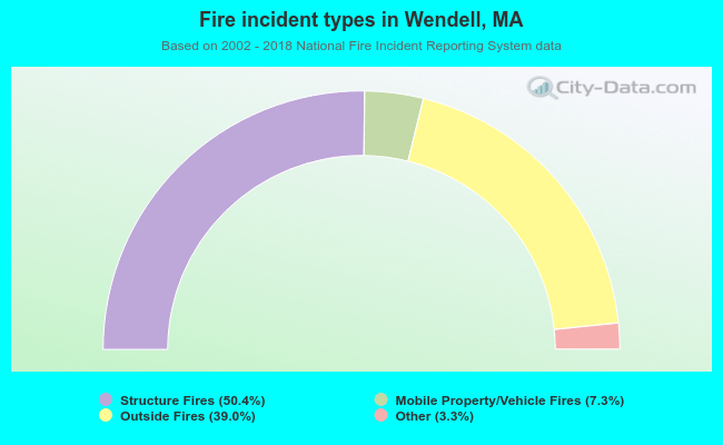 When looking into fire subcategories, the most incidents belonged to: Structure Fires (50.4%), and Outside Fires (39.0%).
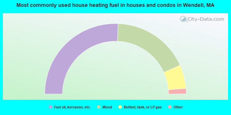
- 51.2%Fuel oil, kerosene, etc.
- 35.4%Wood
- 10.9%Bottled, tank, or LP gas
- 1.6%Electricity
- 0.6%Solar energy
- 0.3%Utility gas
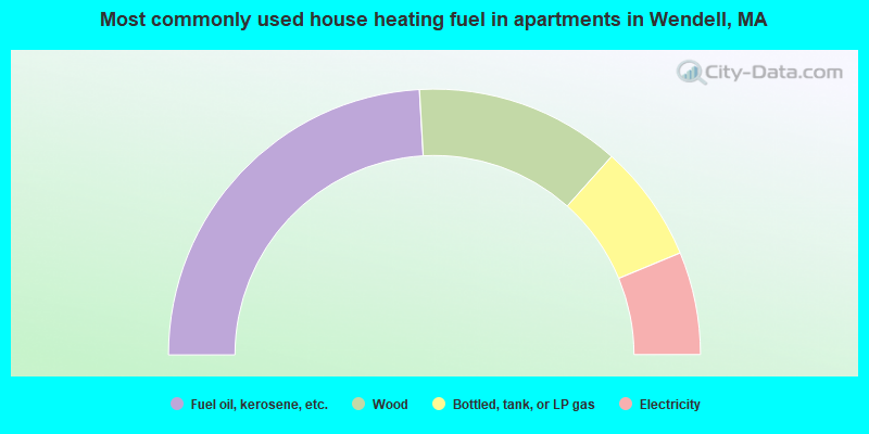
- 48.2%Fuel oil, kerosene, etc.
- 25.0%Wood
- 14.3%Bottled, tank, or LP gas
- 12.5%Electricity
Wendell compared to Massachusetts state average:
- Median house value below state average.
- Unemployed percentage significantly below state average.
- Black race population percentage significantly below state average.
- Hispanic race population percentage significantly below state average.
- Median age significantly above state average.
- Foreign-born population percentage significantly below state average.
- Renting percentage significantly below state average.
- Length of stay since moving in significantly above state average.
- Number of rooms per house significantly below state average.
- House age significantly below state average.
- Institutionalized population percentage significantly above state average.

|
Total of 2 patent applications in 2008-2024.