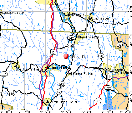
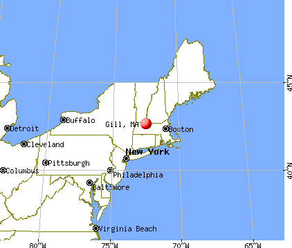
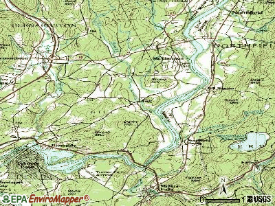
Gill, Massachusetts

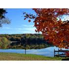
Gill: Barton Cove, Gill, MA
Gill: Barton Cove, Gill, MA

Gill: Barton Cove, Gill, MA
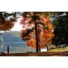
Gill: Barton Cove, Gill, MA
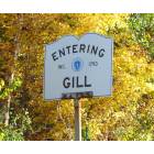
Gill: Entering Gill, MA
- add
your


Submit your own pictures of this town and show them to the world
- OSM Map
- General Map
- Google Map
- MSN Map
Population change since 2000: +10.1%
 |
| Males: 746 | |
| Females: 754 |
| Median resident age: | 46.8 years |
| Massachusetts median age: | 39.2 years |
Zip codes: 01376.
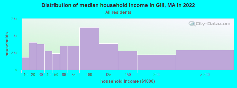
| Gill: | $87,520 |
| MA: | $94,488 |
Estimated per capita income in 2022: $42,599 (it was $23,381 in 2000)
Gill town income, earnings, and wages data
Estimated median house or condo value in 2022: $300,209 (it was $120,800 in 2000)
| Gill: | $300,209 |
| MA: | $534,700 |
Mean prices in 2022: all housing units: $313,377; detached houses: $324,224; townhouses or other attached units: $284,225; in 2-unit structures: $287,978; in 3-to-4-unit structures: $183,938; in 5-or-more-unit structures: $249,762; mobile homes: $62,200
Detailed information about poverty and poor residents in Gill, MA


- 1,43995.9%White alone
- 191.3%Asian alone
- 130.9%Black alone
- 140.9%Two or more races
- 120.8%Hispanic
- 30.2%American Indian alone

Races in Gill detailed stats: ancestries, foreign born residents, place of birth
According to our research of Massachusetts and other state lists, there were 2 registered sex offenders living in Gill, Massachusetts as of May 01, 2024.
The ratio of all residents to sex offenders in Gill is 750 to 1.
Type |
2009 |
2010 |
2011 |
2012 |
2013 |
2014 |
2018 |
2019 |
2020 |
2021 |
2022 |
|---|---|---|---|---|---|---|---|---|---|---|---|
| Murders (per 100,000) | 0 (0.0) | 0 (0.0) | 0 (0.0) | 0 (0.0) | 0 (0.0) | 0 (0.0) | 0 (0.0) | 0 (0.0) | 0 (0.0) | 0 (0.0) | 0 (0.0) |
| Rapes (per 100,000) | 0 (0.0) | 0 (0.0) | 0 (0.0) | 0 (0.0) | 0 (0.0) | 0 (0.0) | 2 (133.5) | 0 (0.0) | 0 (0.0) | 0 (0.0) | 0 (0.0) |
| Robberies (per 100,000) | 0 (0.0) | 0 (0.0) | 0 (0.0) | 0 (0.0) | 0 (0.0) | 0 (0.0) | 0 (0.0) | 0 (0.0) | 0 (0.0) | 0 (0.0) | 0 (0.0) |
| Assaults (per 100,000) | 0 (0.0) | 1 (66.7) | 0 (0.0) | 0 (0.0) | 1 (66.5) | 1 (67.2) | 2 (133.5) | 0 (0.0) | 0 (0.0) | 2 (135.8) | 0 (0.0) |
| Burglaries (per 100,000) | 10 (716.3) | 9 (600.0) | 3 (198.8) | 10 (658.8) | 5 (332.7) | 7 (470.4) | 3 (200.3) | 1 (67.1) | 1 (68.3) | 0 (0.0) | 0 (0.0) |
| Thefts (per 100,000) | 13 (931.2) | 16 (1,067) | 7 (463.9) | 9 (592.9) | 7 (465.7) | 6 (403.2) | 12 (801.1) | 9 (604.0) | 5 (341.5) | 9 (611.0) | 9 (586.3) |
| Auto thefts (per 100,000) | 2 (143.3) | 0 (0.0) | 1 (66.3) | 0 (0.0) | 0 (0.0) | 1 (67.2) | 1 (66.8) | 0 (0.0) | 1 (68.3) | 0 (0.0) | 0 (0.0) |
| Arson (per 100,000) | 0 (0.0) | 1 (66.7) | 1 (66.3) | 0 (0.0) | 0 (0.0) | 0 (0.0) | 0 (0.0) | 0 (0.0) | 0 (0.0) | 0 (0.0) | 0 (0.0) |
| City-Data.com crime index | 98.9 | 98.0 | 37.8 | 69.8 | 55.2 | 67.9 | 184.9 | 28.9 | 23.9 | 51.6 | 23.5 |
The City-Data.com crime index weighs serious crimes and violent crimes more heavily. Higher means more crime, U.S. average is 246.1. It adjusts for the number of visitors and daily workers commuting into cities.
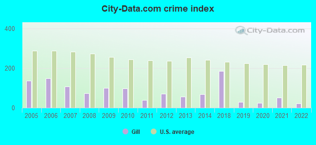
Crime rate in Gill detailed stats: murders, rapes, robberies, assaults, burglaries, thefts, arson
Full-time law enforcement employees in 2021, including police officers: 2 (2 officers - 2 male; 0 female).
| Officers per 1,000 residents here: | 1.36 |
| Massachusetts average: | 2.53 |
 Recent articles from our blog. Our writers, many of them Ph.D. graduates or candidates, create easy-to-read articles on a wide variety of topics.


 | 2023 Real Estate Observations (5278 replies) |
| Big MA Ancestry Data Thread by Town (31 replies) |
| Possibilities in Western Mass for mid-life couple w/no kids (22 replies) |
| Which Franklin county town for young family? (12 replies) |
| How Much Massachusetts Households Make Per Year: Census Data (37 replies) |
| Old Farm but New Needs (95 replies) |
Latest news from Gill, MA collected exclusively by city-data.com from local newspapers, TV, and radio stations
Ancestries: English (17.6%), French (16.4%), Polish (16.4%), Irish (14.9%), French Canadian (8.8%), Italian (7.1%).
Current Local Time: EST time zone
Incorporated in 1793
Elevation: 280 feet
Land area: 14.0 square miles.
Population density: 107 people per square mile (very low).
21 residents are foreign born
| This town: | 1.5% |
| Massachusetts: | 12.2% |
| Gill town: | 1.3% ($1,569) |
| Massachusetts: | 1.3% ($2,336) |
Nearest city with pop. 50,000+: Chicopee, MA  (32.5 miles , pop. 54,653).
Nearest city with pop. 200,000+: Boston, MA (76.2 miles , pop. 589,141).
Nearest city with pop. 1,000,000+: Bronx, NY (142.2 miles , pop. 1,332,650).
Nearest cities:
), ), ), ), Latitude: 42.64 N, Longitude: 72.52 W
Area code commonly used in this area: 413

Single-family new house construction building permits:
- 2022: 1 building, cost: $1,100,800
- 2021: 1 building, cost: $517,000
- 2020: 1 building, cost: $250,000
- 2019: 2 buildings, average cost: $190,000
- 2018: 2 buildings, average cost: $240,000
- 2017: 1 building, cost: $269,000
- 2016: 1 building, cost: $100,000
- 2015: 3 buildings, average cost: $230,100
- 2014: 4 buildings, average cost: $280,000
- 2013: 4 buildings, average cost: $370,000
- 2011: 2 buildings, average cost: $424,000
- 2010: 1 building, cost: $128,200
- 2009: 3 buildings, average cost: $358,500
- 2008: 1 building, cost: $378,600
- 2007: 5 buildings, average cost: $223,200
- 2006: 6 buildings, average cost: $277,100
- 2005: 1 building, cost: $242,200
- 2004: 4 buildings, average cost: $235,900
- 2003: 11 buildings, average cost: $186,600
- 2002: 5 buildings, average cost: $126,700
- 2001: 2 buildings, average cost: $162,100
- 2000: 4 buildings, average cost: $166,000
- 1999: 4 buildings, average cost: $99,400
- 1998: 4 buildings, average cost: $114,200
- 1997: 4 buildings, average cost: $101,500


| Here: | 2.3% |
| Massachusetts: | 3.5% |


- Educational services (17.9%)
- Health care (10.6%)
- Construction (5.8%)
- Public administration (5.5%)
- Food & beverage stores (4.1%)
- Miscellaneous manufacturing (3.9%)
- Finance & insurance (3.8%)

- Educational services (12.5%)
- Construction (9.2%)
- Public administration (6.9%)
- Miscellaneous manufacturing (4.8%)
- Food & beverage stores (4.6%)
- Repair & maintenance (4.1%)
- Plastics & rubber products (4.1%)

- Educational services (23.6%)
- Health care (17.9%)
- Finance & insurance (7.3%)
- Public administration (4.1%)
- Personal & laundry services (3.8%)
- Religious, grantmaking, civic, professional, similar organizations (3.8%)
- Food & beverage stores (3.5%)

- Other production occupations, including supervisors (6.3%)
- Other management occupations, except farmers and farm managers (5.9%)
- Other office and administrative support workers, including supervisors (5.5%)
- Preschool, kindergarten, elementary, and middle school teachers (5.1%)
- Other sales and related occupations, including supervisors (4.3%)
- Material recording, scheduling, dispatching, and distributing workers (3.7%)
- Secretaries and administrative assistants (3.5%)

- Other production occupations, including supervisors (8.7%)
- Other management occupations, except farmers and farm managers (5.6%)
- Metal workers and plastic workers (5.3%)
- Vehicle and mobile equipment mechanics, installers, and repairers (4.6%)
- Material recording, scheduling, dispatching, and distributing workers (4.6%)
- Laborers and material movers, hand (3.8%)
- Driver/sales workers and truck drivers (3.8%)

- Other office and administrative support workers, including supervisors (8.2%)
- Preschool, kindergarten, elementary, and middle school teachers (7.6%)
- Secretaries and administrative assistants (6.8%)
- Other management occupations, except farmers and farm managers (6.2%)
- Other sales and related occupations, including supervisors (5.7%)
- Registered nurses (5.2%)
- Other production occupations, including supervisors (3.8%)
Average climate in Gill, Massachusetts
Based on data reported by over 4,000 weather stations


(lower is better)

Air Quality Index (AQI) level in 2022 was 65.9. This is about average.
| City: | 65.9 |
| U.S.: | 72.6 |


Sulfur Dioxide (SO2) [ppb] level in 2003 was 3.66. This is significantly worse than average. Closest monitor was 6.0 miles away from the city center.
| City: | 3.66 |
| U.S.: | 1.51 |

Ozone [ppb] level in 2022 was 23.8. This is better than average. Closest monitor was 4.5 miles away from the city center.
| City: | 23.8 |
| U.S.: | 33.3 |

Particulate Matter (PM2.5) [µg/m3] level in 2022 was 7.24. This is about average. Closest monitor was 4.5 miles away from the city center.
| City: | 7.24 |
| U.S.: | 8.11 |
Tornado activity:
Gill-area historical tornado activity is above Massachusetts state average. It is 14% smaller than the overall U.S. average.
On 6/9/1953, a category F4 (max. wind speeds 207-260 mph) tornado 21.3 miles away from the Gill town center killed 90 people and injured 1228 people and caused between $50,000,000 and $500,000,000 in damages.
On 10/3/1979, a category F4 tornado 41.7 miles away from the town center killed 3 people and injured 500 people and caused between $50,000,000 and $500,000,000 in damages.
Earthquake activity:
Gill-area historical earthquake activity is significantly above Massachusetts state average. It is 70% smaller than the overall U.S. average.On 10/7/1983 at 10:18:46, a magnitude 5.3 (5.1 MB, 5.3 LG, 5.1 ML, Class: Moderate, Intensity: VI - VII) earthquake occurred 129.2 miles away from the city center
On 4/20/2002 at 10:50:47, a magnitude 5.3 (5.3 ML, Depth: 3.0 mi) earthquake occurred 142.4 miles away from the city center
On 4/20/2002 at 10:50:47, a magnitude 5.2 (5.2 MB, 4.2 MS, 5.2 MW, 5.0 MW) earthquake occurred 141.3 miles away from the city center
On 1/19/1982 at 00:14:42, a magnitude 4.7 (4.5 MB, 4.7 MD, 4.5 LG, Class: Light, Intensity: IV - V) earthquake occurred 75.6 miles away from the city center
On 10/16/2012 at 23:12:25, a magnitude 4.7 (4.7 ML, Depth: 10.0 mi) earthquake occurred 115.2 miles away from Gill center
On 10/2/1994 at 11:27:22, a magnitude 3.7 (3.5 LG, 3.7 LG, Depth: 6.2 mi, Class: Light, Intensity: II - III) earthquake occurred 23.6 miles away from the city center
Magnitude types: regional Lg-wave magnitude (LG), body-wave magnitude (MB), duration magnitude (MD), local magnitude (ML), surface-wave magnitude (MS), moment magnitude (MW)
Natural disasters:
The number of natural disasters in Franklin County (20) is greater than the US average (15).Major Disasters (Presidential) Declared: 9
Emergencies Declared: 10
Causes of natural disasters: Floods: 5, Storms: 5, Hurricanes: 4, Snowstorms: 4, Winter Storms: 3, Blizzards: 2, Snows: 2, Snowfall: 1, Tropical Storm: 1, Wind: 1, Other: 1 (Note: some incidents may be assigned to more than one category).
Hospitals and medical centers near Gill:
- NURSE'S HOUSE CALL - GREENFIELD (Home Health Center, about 4 miles away; GREENFIELD, MA)
- YANKEE FAMILY DIALYSIS CENTER (Dialysis Facility, about 4 miles away; GREENFIELD, MA)
- POET'S SEAT HEALTH CARE CENTER (Nursing Home, about 4 miles away; GREENFIELD, MA)
- BAYSTATE FRANKLIN MEDICAL CENTER Acute Care Hospitals (about 5 miles away; GREENFIELD, MA)
- HOSPICE OF FRANKLIN COUNTY (Hospital, about 5 miles away; GREENFIELD, MA)
- HOSPICE OF FRANKLIN COUNTY, INC (Hospital, about 6 miles away; GREENFIELD, MA)
- FRANKLIN CENTER (Nursing Home, about 6 miles away; GREENFIELD, MA)
Amtrak stations near Gill:
- 14 miles: BRATTLEBORO (VERNON RD.) . Services: enclosed waiting area, public restrooms, call for car rental service, call for taxi service.
- 19 miles: AMHERST (RAILROAD ST.) . Services: enclosed waiting area, public payphones, free short-term parking, paid long-term parking, call for car rental service, call for taxi service, public transit connection.
Operable nuclear power plant near Gill:
- 10 miles: Vermont Yankee in Vernon, VT.
Colleges/universities with over 2000 students nearest to Gill:
- University of Massachusetts-Amherst (about 18 miles; Amherst, MA; Full-time enrollment: 26,583)
- Smith College (about 23 miles; Northampton, MA; FT enrollment: 3,549)
- Keene State College (about 24 miles; Keene, NH; FT enrollment: 5,098)
- Franklin Pierce University (about 26 miles; Rindge, NH; FT enrollment: 2,139)
- Mount Holyoke College (about 27 miles; South Hadley, MA; FT enrollment: 2,573)
- Mount Wachusett Community College (about 28 miles; Gardner, MA; FT enrollment: 3,143)
- Holyoke Community College (about 32 miles; Holyoke, MA; FT enrollment: 4,911)
Public elementary/middle school in Gill:
- GILL ELEMENTARY (Students: 103, Location: 48 BOYLE RD, Grades: KG-6)
User-submitted facts and corrections:
- WLPV radio in Gill, MA. 107.9 FM station from 450 Davis Street in Greenfield, MA 01301. Radio from Living Waters Assembly of God Church.
Points of interest:
Notable location: Gill Fire Department (A). Display/hide its location on the map
Cemeteries: Riverside Cemetery (1), Gill Center Cemetery (2), North Cemetery (3). Display/hide their locations on the map
Lakes and reservoirs: Otter Pond (A), Shadow Lake (B), Connecticut River Reservoir (C), Fall River Reservoir (D). Display/hide their locations on the map
Streams, rivers, and creeks: Ashuela Brook (A), Bennett Brook (B), Dry Brook (C), Otter Run (D), Otter Brook (E). Display/hide their locations on the map
Birthplace of: Matt Striebel - Lacrosse player.
| This town: | 2.4 people |
| Massachusetts: | 2.5 people |
| This town: | 66.4% |
| Whole state: | 63.0% |
| This town: | 7.6% |
| Whole state: | 7.0% |
Likely homosexual households (counted as self-reported same-sex unmarried-partner households)
- Lesbian couples: 1.1% of all households
- Gay men: 0.7% of all households
| This town: | 4.4% |
| Whole state: | 9.3% |
| This town: | 1.5% |
| Whole state: | 4.4% |
10 people in group homes intended for adults in 2010
4 people in other nonhousehold living situations in 2000
For population 15 years and over in Gill:

- Never married: 22.3%
- Now married: 61.0%
- Separated: 1.9%
- Widowed: 7.3%
- Divorced: 7.5%
For population 25 years and over in Gill:
- High school or higher: 90.4%
- Bachelor's degree or higher: 27.9%
- Graduate or professional degree: 12.4%
- Unemployed: 3.2%
- Mean travel time to work (commute): 21.9 minutes


| Here: | 10.4 |
| Massachusetts average: | 13.1 |


Graphs represent county-level data. Detailed 2008 Election Results
Religion statistics for Gill, MA (based on Franklin County data)


| Religion | Adherents | Congregations |
|---|---|---|
| Catholic | 16,509 | 15 |
| Mainline Protestant | 4,617 | 38 |
| Evangelical Protestant | 2,079 | 20 |
| Other | 1,580 | 21 |
| None | 46,587 | - |
Food Environment Statistics:
| Franklin County: | 3.63 / 10,000 pop. |
| State: | 1.98 / 10,000 pop. |
| This county: | 0.14 / 10,000 pop. |
| Massachusetts: | 0.05 / 10,000 pop. |
| Franklin County: | 1.67 / 10,000 pop. |
| State: | 2.22 / 10,000 pop. |
| This county: | 3.21 / 10,000 pop. |
| State: | 1.77 / 10,000 pop. |
| This county: | 8.10 / 10,000 pop. |
| Massachusetts: | 8.76 / 10,000 pop. |
| Here: | 7.5% |
| Massachusetts: | 8.1% |
| Franklin County: | 22.2% |
| Massachusetts: | 22.5% |
| Franklin County: | 15.1% |
| State: | 16.5% |
Strongest AM radio stations in Gill:
- WIZZ (1520 AM; daytime; 10 kW; GREENFIELD, MA; Owner: P. & M. RADIO, LLC)
- WNNZ (640 AM; 50 kW; WESTFIELD, MA; Owner: CLEAR CHANNEL BROADCASTING LICENSES, INC.)
- WCRN (830 AM; 50 kW; WORCESTER, MA; Owner: CARTER BROADCASTING CORPORATION)
- WVNE (760 AM; daytime; 25 kW; LEICESTER, MA; Owner: BLOUNT MASSCOM, INC.)
- WHMQ (1240 AM; 1 kW; GREENFIELD, MA; Owner: SAGA COMMUNICATIONS OF NEW ENGLAND, LLC)
- WCAT (700 AM; daytime; 2 kW; ORANGE-ATHOL, MA; Owner: CITADEL BROADCASTING COMPANY)
- WRKO (680 AM; 50 kW; BOSTON, MA; Owner: ENTERCOM BOSTON LICENSE, LLC)
- WTIC (1080 AM; 50 kW; HARTFORD, CT; Owner: INFINITY RADIO OPERATIONS INC.)
- WEEI (850 AM; 50 kW; BOSTON, MA; Owner: ENTERCOM BOSTON LICENSE, LLC)
- WKOX (1200 AM; 50 kW; FRAMINGHAM, MA; Owner: CAPSTAR TX LIMITED PARTNERSHIP)
- WALE (990 AM; 50 kW; GREENVILLE, RI; Owner: NORTH AMERICAN BROADCASTING CO., INC.)
- WGY (810 AM; 50 kW; SCHENECTADY, NY; Owner: CLEAR CHANNEL BROADCASTING LICENSES, INC.)
- WBIX (1060 AM; 40 kW; NATICK, MA; Owner: LANGER BROADCASTING CORPORATION)
Strongest FM radio stations in Gill:
- WPVQ (95.3 FM; GREENFIELD, MA; Owner: GREAT NORTHERN RADIO, L.L.C.)
- WHAI (98.3 FM; GREENFIELD, MA; Owner: SAGA COMMUNICATIONS OF NEW ENGLAND, LLC)
- WYRY (104.9 FM; HINSDALE, NH; Owner: TRI-VALLEY BROADCASTING CORPORATION)
- WRSI (93.9 FM; TURNERS FALLS, MA; Owner: GREAT NORTHERN RADIO, LLC)
- WJDF (97.3 FM; ORANGE, MA; Owner: DEANE BROTHERS BROADCASTING CORP.)
- WGAJ (91.7 FM; DEERFIELD, MA; Owner: TRUATEES OF DEERFIELD ACADEMY)
- WAMC-FM (90.3 FM; ALBANY, NY; Owner: WAMC)
- WFCR (88.5 FM; AMHERST, MA; Owner: UNIVERSITY OF MASSACHUSETTS)
- WRSY (101.5 FM; MARLBORO, VT; Owner: GREAT NORTHERN RADIO, L.L.C.)
- WOQL (98.7 FM; WINCHESTER, NH; Owner: SAGA COMMUNICATIONS OF NEW HAMPSHIRE, LLC)
- WVAY (100.7 FM; WILMINGTON, VT; Owner: GREAT NORTHERN RADIO, L.L.C.)
- WEQX (102.7 FM; MANCHESTER, VT; Owner: NORTHSHIRE COMMUNICATIONS, INC.)
- WJAN (95.1 FM; SUNDERLAND, VT; Owner: 6 JOHNSON ROAD LICENSES, INC.)
- WAMH (89.3 FM; AMHERST, MA; Owner: TRUSTEES OF AMHERST COLLEGE)
- WKVT-FM (92.7 FM; BRATTLEBORO, VT; Owner: SAGA COMMUNICATIONS OF NEW ENGLAND, LLC)
- WFEX (92.1 FM; PETERBOROUGH, NH; Owner: FNX BROADCASTING OF NEW HAMPSHIRE LLC)
- WHYN-FM (93.1 FM; SPRINGFIELD, MA; Owner: CLEAR CHANNEL BROADCASTING LICENSES, INC.)
- WKNE (103.7 FM; KEENE, NH; Owner: SAGA COMMUNICATIONS OF NEW ENGLAND, LLC)
- WCMK (91.9 FM; PUTNEY, VT; Owner: CHRISTIAN MINISTRIES INC)
- WHDQ (106.1 FM; CLAREMONT, NH; Owner: GREAT NORTHERN RADIO, L.L.C.)
TV broadcast stations around Gill:
- WYDN (Channel 48; WORCESTER, MA; Owner: EDUCATIONAL PUBLIC TV CORPORATION)
- WUNI (Channel 27; WORCESTER, MA; Owner: ENTRAVISION HOLDINGS, LLC)
- WEKW-TV (Channel 52; KEENE, NH; Owner: UNIVERSITY OF NEW HAMPSHIRE)
- W35BK (Channel 35; PLAINFIELD, MA; Owner: LYDIA SYLVANE STOCKWELL)
Gill fatal accident list:
Nov 23, 2013 07:45 PM, Sr-2 French King Highway, Set Back Lane, Lat: 42.607028, Lon: -72.529694, Vehicles: 3, Persons: 10, Fatalities: 1
Sep 12, 2012 02:03 AM, Sr-2, Lat: 42.599375, Lon: -72.498042, Vehicles: 1, Persons: 1, Fatalities: 1
Jun 13, 2008 04:57 PM, Sr-2, Lat: 42.606740, Lon: -72.576540, Vehicles: 2, Persons: 2, Fatalities: 1, Drunk persons involved: 1
Aug 1, 2007 10:49 PM, Sr-2, French King Hwy, Lat: 42.613811, Lon: -72.549419, Vehicles: 1, Persons: 2, Pedestrians: 1, Fatalities: 1
Dec 17, 2005 11:16 AM, West Gill Rd, Lat: 42.642790, Lon: -72.527480, Vehicles: 1, Persons: 1, Fatalities: 1
Feb 1, 1997 06:30 PM, Rte110, Vehicles: 2, Persons: 2, Fatalities: 1
- National Bridge Inventory (NBI) Statistics
- 4Number of bridges
- 203ft / 62.0mTotal length
- $41,744,000Total costs
- 36,965Total average daily traffic
- 3,670Total average daily truck traffic
- 33,460Total future (year 2031) average daily traffic
FCC Registered Antenna Towers:
4- EDWIN PRONDECKI, 235 French King Highway Rt. 2 (Lat: 42.608944 Lon: -72.510861), Type: 39.6, Overall height: 39.6 m, Registrant: Gill, Phone: (413) 863-4364
- Leslie N Nixon, 235 French King Highway Rt. 2 (Lat: 42.608944 Lon: -72.510861), Type: 39.6, Overall height: 39.6 m, Registrant: Global Tower, LLC, Fcc-Contact@gtpsites.Com, , Boca -Raton, Phone: (561) 886-3925
- Leslie N Nixon, 235 French King Highway Rt. 2 (Lat: 42.608944 Lon: -72.510861), Type: 39.6, Overall height: 39.6 m, Registrant: Global Tower, LLC, Fcc-Contact@gtpsites.Com, , Boca -Raton, Phone: (561) 886-3925
- Kristen Cesana, 235 French King Highway Rt. 2 (Lat: 42.608944 Lon: -72.510861), Type: 39.6, Structure height: 25011 m, Overall height: 39.6 m, Registrant: Global Tower, LLC, Fcc-Contact@gtpsites.Com, , Boca -Raton, Phone: (561) 886-3925
FCC Registered Microwave Towers:
1- STATION, Turners Falls Headgate (Lat: 42.611472 Lon: -72.551194), Overall height: 6.1 m, Call Sign: WNTQ636,
Assigned Frequencies: 22075.0 MHz, Grant Date: 01/30/2008, Expiration Date: 03/18/2018, Cancellation Date: 05/19/2018, Certifier: Stephen Herman, Registrant: Firstlight Power Resources Services, LLC, 99 Millers Falls Road, Northfield, MA 01360, Phone: (413) 536-9531, Fax: (413) 536-9513, Email:
FCC Registered Amateur Radio Licenses:
9 (See the full list of FCC Registered Amateur Radio Licenses in Gill)FAA Registered Aircraft:
3- Aircraft: CESSNA 172L (Category: Land, Seats: 4, Weight: Up to 12,499 Pounds, Speed: 105 mph), Engine: LYCOMING 0-320 SERIES (180 HP) (Reciprocating)
N-Number: 4385Q, N4385Q, N-4385Q, Serial Number: 17260285, Year manufactured: 1971, Airworthiness Date: 12/04/1971, Certificate Issue Date: 04/21/1992
Registrant (Individual): Richard W Kulis, 90 Center Rd, Gill, MA 01354 - Aircraft: CESSNA 182Q (Category: Land, Seats: 4, Weight: Up to 12,499 Pounds, Speed: 112 mph), Engine: CONT MOTOR O-470 SERIES (230 HP) (Reciprocating)
N-Number: 6DR, N6DR, N-6DR, Serial Number: 18266779, Year manufactured: 1979, Airworthiness Date: 01/29/1998, Certificate Issue Date: 10/31/2011
Registrant (Individual): Robert Dba Higgins, 180 French King Hwy, Gill, MA 01354, Other Owners: Wholesale Atlantic - Aircraft: CESSNA 172M (Category: Land, Seats: 4, Weight: Up to 12,499 Pounds, Speed: 108 mph), Engine: LYCOMING 0-320 SERIES (180 HP) (4 Cycle)
N-Number: 9654Q, N9654Q, N-9654Q, Serial Number: 17265738, Year manufactured: 1975, Airworthiness Date: 09/05/1975, Certificate Issue Date: 06/25/2019
Registrant (LLC): Fly Pioneer Valley LLC, 43 Riverview Dr, Gill, MA 01354
2002 - 2018 National Fire Incident Reporting System (NFIRS) incidents
- Fire incident types reported to NFIRS in Gill, MA
- 11042.0%Outside Fires
- 10841.2%Structure Fires
- 269.9%Mobile Property/Vehicle Fires
- 186.9%Other
 According to the data from the years 2002 - 2018 the average number of fire incidents per year is 15. The highest number of fire incidents - 25 took place in 2002, and the least - 7 in 2003. The data has a decreasing trend.
 When looking into fire subcategories, the most reports belonged to: Outside Fires (42.0%), and Structure Fires (41.2%).
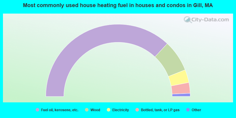
- 73.9%Fuel oil, kerosene, etc.
- 14.1%Wood
- 5.8%Electricity
- 4.8%Bottled, tank, or LP gas
- 0.5%Utility gas
- 0.5%Coal or coke
- 0.5%Other fuel
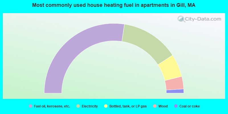
- 54.8%Fuel oil, kerosene, etc.
- 26.9%Electricity
- 10.6%Bottled, tank, or LP gas
- 5.8%Wood
- 1.9%Coal or coke
Gill compared to Massachusetts state average:
- Median house value below state average.
- Unemployed percentage significantly below state average.
- Black race population percentage significantly below state average.
- Hispanic race population percentage significantly below state average.
- Median age above state average.
- Foreign-born population percentage significantly below state average.
- Renting percentage below state average.
- Length of stay since moving in significantly above state average.
- Number of rooms per house significantly below state average.
- House age significantly below state average.
- Number of college students below state average.