Erving, Massachusetts
Submit your own pictures of this town and show them to the world
- OSM Map
- General Map
- Google Map
- MSN Map
Population change since 2000: +22.7%
| Males: 881 | |
| Females: 919 |
| Median resident age: | 41.3 years |
| Massachusetts median age: | 39.2 years |
Zip codes: 01344.
| Erving: | $69,049 |
| MA: | $94,488 |
Estimated per capita income in 2022: $34,812 (it was $19,107 in 2000)
Erving town income, earnings, and wages data
Estimated median house or condo value in 2022: $240,068 (it was $96,600 in 2000)
| Erving: | $240,068 |
| MA: | $534,700 |
Mean prices in 2022: all housing units: $313,377; detached houses: $324,224; townhouses or other attached units: $284,225; in 2-unit structures: $287,978; in 3-to-4-unit structures: $183,938; in 5-or-more-unit structures: $249,762; mobile homes: $62,200
Detailed information about poverty and poor residents in Erving, MA


Compare current foreclosures near Erving, MA:
| Photo | Address | Area | Beds / Baths | Price | Details |
|---|---|---|---|---|---|

|
#1
Pratt St
Erving, MA 01344
|
3,000 sq. feet
|
4 baths 7 beds |
show details | |

|
#2
Ridge Rd
Erving, MA 01344
|
1,232 sq. feet
|
1 baths - beds |
show details | |

|
#3
Whipple Hill Rd
Winchester, NH 03470
|
1,374 sq. feet
|
2 baths 2 beds |
$379,900
|
show details |

|
#4
Lampblack Rd
Greenfield, MA 01301
|
2,078 sq. feet
|
1 baths 3 beds |
$369,900
|
show details |

|
#5
Route 2
Shelburne Falls, MA 01370
|
- sq. feet
|
3 baths 6 beds |
$229,900
|
show details |

|
#6
N Orange Rd
Athol, MA 01331
|
950 sq. feet
|
1 baths 3 beds |
show details | |

|
#7
J St
Turners Falls, MA 01376
|
3,256 sq. feet
|
2 baths 7 beds |
show details | |

|
#8
Sabans Rd
Conway, MA 01341
|
1,246 sq. feet
|
2 baths 3 beds |
show details | |

|
#9
West St
Greenfield, MA 01301
|
1,858 sq. feet
|
2 baths 3 beds |
show details | |

|
#10
White Pond Rd
Athol, MA 01331
|
2,340 sq. feet
|
2 baths 5 beds |
show details |
| Photo | Address | Area | Beds / Baths | Price | Details |
|---|---|---|---|---|---|

|
#11
Ella St
Athol, MA 01331
|
1,026 sq. feet
|
1 baths 2 beds |
show details | |

|
#12
South St
Athol, MA 01331
|
1,135 sq. feet
|
1 baths 3 beds |
show details | |

|
#13
N Main St
South Deerfield, MA 01373
|
2,143 sq. feet
|
1 baths 5 beds |
show details | |

|
#14
Prescott Ln
Orange, MA 01364
|
2,064 sq. feet
|
2 baths 3 beds |
show details | |

|
#15
Oak Ave
Athol, MA 01331
|
1,362 sq. feet
|
2 baths 4 beds |
show details | |

|
#16
East Rd
Orange, MA 01364
|
960 sq. feet
|
1 baths 3 beds |
show details | |

|
#17
Braeburn Rd
South Deerfield, MA 01373
|
1,661 sq. feet
|
1 baths 3 beds |
show details | |

|
#18
Sunderland Rd
South Deerfield, MA 01373
|
1,385 sq. feet
|
1 baths 3 beds |
show details | |

|
#19
Everett St
Athol, MA 01331
|
1,080 sq. feet
|
1 baths 3 beds |
show details | |

|
#20
Leonard St
Athol, MA 01331
|
2,542 sq. feet
|
2 baths 4 beds |
show details |
| Photo | Address | Area | Beds / Baths | Price | Details |
|---|---|---|---|---|---|

|
#21
Chestnut St
Athol, MA 01331
|
1,503 sq. feet
|
2 baths 4 beds |
show details | |

|
#22
Central St
Athol, MA 01331
|
1,397 sq. feet
|
2 baths 3 beds |
show details | |

|
#23
Riceville Rd
Athol, MA 01331
|
1,304 sq. feet
|
2 baths 3 beds |
show details | |

|
#24
Jacksonville Rd
Colrain, MA 01340
|
1,108 sq. feet
|
1 baths 2 beds |
show details | |

|
#25
Norcross Rd
Royalston, MA 01368
|
1,605 sq. feet
|
3 baths 4 beds |
show details | |

|
#26
Purington Ln
Colrain, MA 01340
|
2,030 sq. feet
|
1 baths 5 beds |
show details | |

|
#27
S Royalston Rd
Royalston, MA 01368
|
4,287 sq. feet
|
3 baths 5 beds |
show details | |

|
#28
Chesterfield Rd
Hinsdale, NH 03451
|
1,796 sq. feet
|
1 baths 3 beds |
show details | |

|
#29
Long Plain Rd
South Deerfield, MA 01373
|
1,909 sq. feet
|
2 baths 4 beds |
show details | |

|
#30
Pine St
Amherst, MA 01002
|
2,195 sq. feet
|
2 baths 4 beds |
show details |
| Photo | Address | Area | Beds / Baths | Price | Details |
|---|---|---|---|---|---|

|
#31
Sand Hill Rd
Amherst, MA 01002
|
2,037 sq. feet
|
3 baths 5 beds |
show details | |

|
#32
Park St
Athol, MA 01331
|
1,000 sq. feet
|
1 baths 2 beds |
show details | |

|
#33
Brattleboro Rd
Hinsdale, NH 03451
|
1,150 sq. feet
|
1 baths 2 beds |
show details | |

|
#34
Templeton Rd
Athol, MA 01331
|
960 sq. feet
|
1 baths 2 beds |
show details | |

|
#35
Main St
Athol, MA 01331
|
1,236 sq. feet
|
1 baths 3 beds |
show details | |

|
#36
Plumtree Rd
Sunderland, MA 01375
|
1,536 sq. feet
|
2 baths 2 beds |
show details | |

|
#37
Kennebunk St
Athol, MA 01331
|
3,518 sq. feet
|
2 baths 4 beds |
show details | |

|
#38
Charden Ln
Athol, MA 01331
|
1,200 sq. feet
|
1 baths 3 beds |
show details | |

|
#39
Briggs Rd
Shutesbury, MA 01072
|
1,434 sq. feet
|
1 baths 3 beds |
show details | |

|
#40
Rogers Ave
Orange, MA 01364
|
1,296 sq. feet
|
1 baths 3 beds |
show details |
| Photo | Address | Area | Beds / Baths | Price | Details |
|---|---|---|---|---|---|

|
#41
Daniel Shays Hwy
Athol, MA 01331
|
1,736 sq. feet
|
2 baths 4 beds |
show details | |

|
#42
North St
Hatfield, MA 01038
|
1,900 sq. feet
|
1 baths 3 beds |
show details | |

|
#43
Hope St
Greenfield, MA 01301
|
1,619 sq. feet
|
1 baths 3 beds |
show details | |

|
#44
W Main St
New Salem, MA 01355
|
4,624 sq. feet
|
3 baths 6 beds |
show details | |

|
#45
Bald Mountain Rd
Bernardston, MA 01337
|
918 sq. feet
|
1 baths 2 beds |
show details | |

|
#46
Hillcrest Dr
Bernardston, MA 01337
|
1,120 sq. feet
|
1 baths 3 beds |
show details | |

|
#47
Maple St
Greenfield, MA 01301
|
1,216 sq. feet
|
1 baths 3 beds |
show details | |

|
#48
James St
Greenfield, MA 01301
|
2,176 sq. feet
|
2 baths 4 beds |
show details | |

|
#49
N Main St, Unit A
Orange, MA 01364
|
598 sq. feet
|
1 baths 2 beds |
show details | |

|
Check over 1 million property listings on Foreclosure.com!
|
browse all offers | |||

- 1,72896.0%White alone
- 321.8%Hispanic
- 251.4%Two or more races
- 50.3%Black alone
- 50.3%American Indian alone
- 40.2%Asian alone
- 10.06%Other race alone

Races in Erving detailed stats: ancestries, foreign born residents, place of birth
According to our research of Massachusetts and other state lists, there were 3 registered sex offenders living in Erving, Massachusetts as of May 15, 2024.
The ratio of all residents to sex offenders in Erving is 600 to 1.
Type |
2009 |
2010 |
2011 |
2012 |
2013 |
2014 |
2015 |
2016 |
2017 |
2018 |
2019 |
2020 |
2021 |
2022 |
|---|---|---|---|---|---|---|---|---|---|---|---|---|---|---|
| Murders (per 100,000) | 0 (0.0) | 0 (0.0) | 0 (0.0) | 0 (0.0) | 0 (0.0) | 0 (0.0) | 0 (0.0) | 0 (0.0) | 0 (0.0) | 0 (0.0) | 0 (0.0) | 0 (0.0) | 0 (0.0) | 0 (0.0) |
| Rapes (per 100,000) | 3 (191.9) | 1 (55.6) | 0 (0.0) | 0 (0.0) | 1 (55.5) | 2 (111.4) | 0 (0.0) | 1 (56.5) | 2 (113.4) | 1 (56.8) | 0 (0.0) | 1 (57.3) | 1 (57.3) | 0 (0.0) |
| Robberies (per 100,000) | 0 (0.0) | 0 (0.0) | 0 (0.0) | 0 (0.0) | 0 (0.0) | 0 (0.0) | 0 (0.0) | 0 (0.0) | 0 (0.0) | 0 (0.0) | 0 (0.0) | 0 (0.0) | 0 (0.0) | 0 (0.0) |
| Assaults (per 100,000) | 2 (128.0) | 5 (277.8) | 1 (55.2) | 11 (603.7) | 5 (277.3) | 4 (222.8) | 4 (224.1) | 2 (112.9) | 2 (113.4) | 5 (283.8) | 0 (0.0) | 4 (229.2) | 3 (172.0) | 6 (359.5) |
| Burglaries (per 100,000) | 41 (2,623) | 18 (1,000) | 18 (993.9) | 7 (384.2) | 6 (332.8) | 6 (334.3) | 10 (560.2) | 11 (621.1) | 8 (453.8) | 8 (454.0) | 5 (282.3) | 3 (171.9) | 2 (114.7) | 2 (119.8) |
| Thefts (per 100,000) | 17 (1,088) | 18 (1,000) | 33 (1,822) | 29 (1,592) | 15 (831.9) | 27 (1,504) | 24 (1,345) | 22 (1,242) | 14 (794.1) | 13 (737.8) | 9 (508.2) | 7 (401.1) | 8 (458.7) | 7 (419.4) |
| Auto thefts (per 100,000) | 0 (0.0) | 2 (111.1) | 2 (110.4) | 1 (54.9) | 1 (55.5) | 1 (55.7) | 1 (56.0) | 0 (0.0) | 3 (170.2) | 2 (113.5) | 1 (56.5) | 1 (57.3) | 1 (57.3) | 0 (0.0) |
| Arson (per 100,000) | 0 (0.0) | 0 (0.0) | 0 (0.0) | 0 (0.0) | 2 (110.9) | 0 (0.0) | 0 (0.0) | 2 (112.9) | 0 (0.0) | 0 (0.0) | 0 (0.0) | 0 (0.0) | 0 (0.0) | 0 (0.0) |
| City-Data.com crime index | 406.3 | 218.9 | 162.3 | 215.7 | 160.8 | 221.7 | 142.3 | 160.9 | 190.6 | 172.5 | 44.6 | 124.4 | 111.2 | 97.1 |
The City-Data.com crime index weighs serious crimes and violent crimes more heavily. Higher means more crime, U.S. average is 246.1. It adjusts for the number of visitors and daily workers commuting into cities.

Crime rate in Erving detailed stats: murders, rapes, robberies, assaults, burglaries, thefts, arson
Full-time law enforcement employees in 2021, including police officers: 5 (5 officers - 5 male; 0 female).
| Officers per 1,000 residents here: | 2.87 |
| Massachusetts average: | 2.53 |
 Recent articles from our blog. Our writers, many of them Ph.D. graduates or candidates, create easy-to-read articles on a wide variety of topics.


 | Big MA Ancestry Data Thread by Town (31 replies) |
| Is it possible to escape hunters, ATVs and noise in a rural area? (278 replies) |
| Let's talk about the Quabbin Reservoir (25 replies) |
| New England Trail (6 replies) |
| Is Massachusetts Real Estate Affordable? (132 replies) |
| Which Franklin county town for young family? (12 replies) |
Latest news from Erving, MA collected exclusively by city-data.com from local newspapers, TV, and radio stations
Ancestries: French (18.7%), English (17.2%), Polish (15.7%), Irish (15.1%), French Canadian (10.3%), German (10.0%).
Current Local Time: EST time zone
Incorporated in 1838
Elevation: 475 feet
Land area: 13.9 square miles.
Population density: 130 people per square mile (very low).
30 residents are foreign born (0.8% North America, 0.7% Europe, 0.5% Asia).
| This town: | 2.0% |
| Massachusetts: | 12.2% |
| Erving town: | 0.7% ($681) |
| Massachusetts: | 1.3% ($2,336) |
Nearest city with pop. 50,000+: Chicopee, MA  (30.5 miles , pop. 54,653).
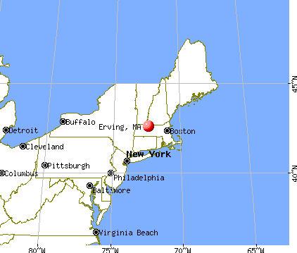
Nearest city with pop. 200,000+: Boston, MA (72.2 miles , pop. 589,141).
Nearest city with pop. 1,000,000+: Bronx, NY (141.6 miles , pop. 1,332,650).
Nearest cities:
), ), ), Latitude: 42.60 N, Longitude: 72.45 W
Area code commonly used in this area: 413


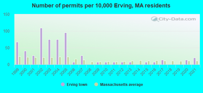
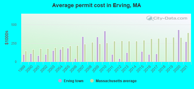
Single-family new house construction building permits:
- 2021: 3 buildings, average cost: $271,300
- 2020: 2 buildings, average cost: $433,000
- 2017: 2 buildings, average cost: $110,000
- 2016: 1 building, cost: $102,000
- 2015: 1 building, cost: $140,000
- 2013: 1 building, cost: $125,000
- 2012: 1 building, cost: $45,000
- 2011: 1 building, cost: $100,000
- 2010: 1 building, cost: $414,700
- 2009: 1 building, cost: $336,200
- 2007: 4 buildings, average cost: $339,300
- 2006: 1 building, cost: $46,200
- 2005: 14 buildings, average cost: $185,800
- 2004: 11 buildings, average cost: $167,800
- 2003: 11 buildings, average cost: $152,300
- 2002: 16 buildings, average cost: $100,200
- 2001: 4 buildings, average cost: $82,500
- 2000: 6 buildings, average cost: $114,100
- 1999: 10 buildings, average cost: $101,100
| Here: | 3.0% |
| Massachusetts: | 3.5% |
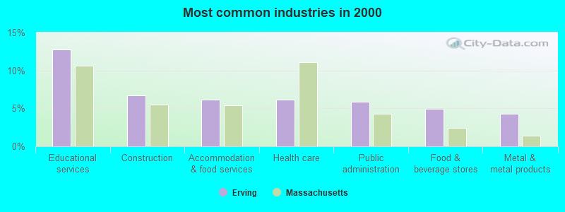
- Educational services (12.8%)
- Construction (6.7%)
- Accommodation & food services (6.1%)
- Health care (6.1%)
- Public administration (5.9%)
- Food & beverage stores (5.0%)
- Metal & metal products (4.3%)
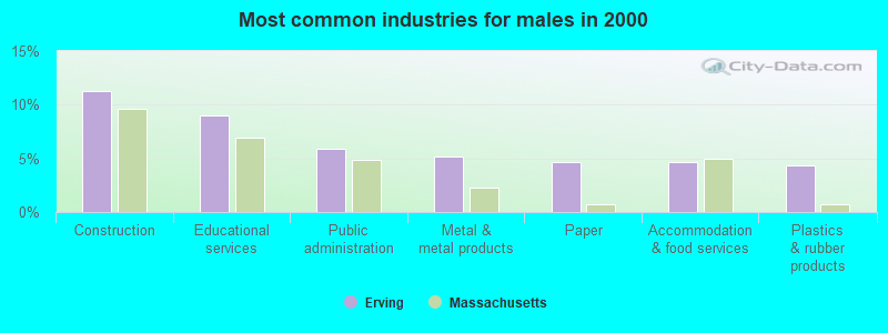
- Construction (11.3%)
- Educational services (9.0%)
- Public administration (5.9%)
- Metal & metal products (5.1%)
- Paper (4.6%)
- Accommodation & food services (4.6%)
- Plastics & rubber products (4.4%)
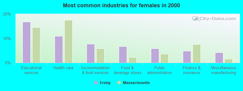
- Educational services (16.8%)
- Health care (10.9%)
- Accommodation & food services (7.7%)
- Food & beverage stores (6.6%)
- Public administration (5.9%)
- Finance & insurance (4.8%)
- Miscellaneous manufacturing (4.3%)
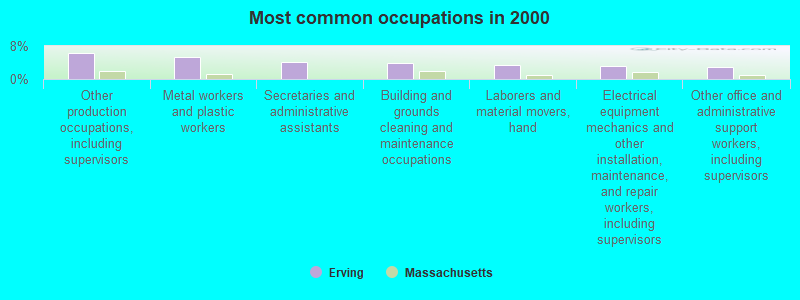
- Other production occupations, including supervisors (6.4%)
- Metal workers and plastic workers (5.2%)
- Secretaries and administrative assistants (4.1%)
- Building and grounds cleaning and maintenance occupations (3.9%)
- Laborers and material movers, hand (3.4%)
- Electrical equipment mechanics and other installation, maintenance, and repair workers, including supervisors (3.1%)
- Other office and administrative support workers, including supervisors (2.9%)
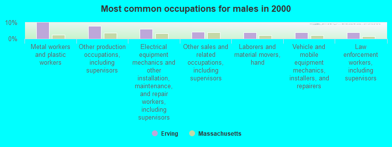
- Metal workers and plastic workers (10.0%)
- Other production occupations, including supervisors (8.0%)
- Electrical equipment mechanics and other installation, maintenance, and repair workers, including supervisors (6.2%)
- Other sales and related occupations, including supervisors (4.4%)
- Laborers and material movers, hand (3.9%)
- Vehicle and mobile equipment mechanics, installers, and repairers (3.9%)
- Law enforcement workers, including supervisors (3.9%)
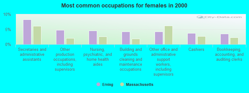
- Secretaries and administrative assistants (8.2%)
- Other production occupations, including supervisors (4.8%)
- Nursing, psychiatric, and home health aides (4.5%)
- Building and grounds cleaning and maintenance occupations (4.3%)
- Other office and administrative support workers, including supervisors (4.3%)
- Cashiers (3.7%)
- Bookkeeping, accounting, and auditing clerks (3.5%)
Average climate in Erving, Massachusetts
Based on data reported by over 4,000 weather stations


(lower is better)

Air Quality Index (AQI) level in 2022 was 69.2. This is about average.
| City: | 69.2 |
| U.S.: | 72.6 |
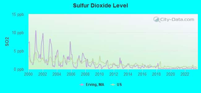
Sulfur Dioxide (SO2) [ppb] level in 2022 was 0.216. This is significantly better than average. Closest monitor was 2.7 miles away from the city center.
| City: | 0.216 |
| U.S.: | 1.515 |
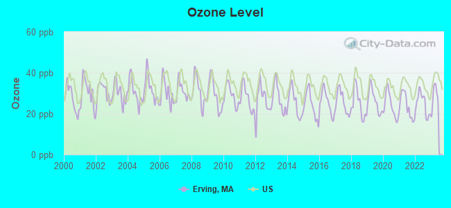
Ozone [ppb] level in 2022 was 24.7. This is better than average. Closest monitor was 4.4 miles away from the city center.
| City: | 24.7 |
| U.S.: | 33.3 |

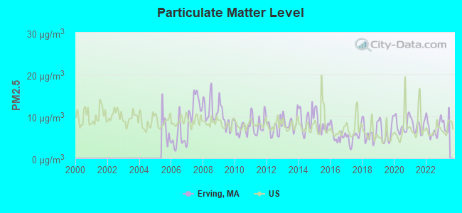
Particulate Matter (PM2.5) [µg/m3] level in 2022 was 7.13. This is about average. Closest monitor was 7.4 miles away from the city center.
| City: | 7.13 |
| U.S.: | 8.11 |
Tornado activity:
Erving-area historical tornado activity is above Massachusetts state average. It is 13% smaller than the overall U.S. average.
On 6/9/1953, a category F4 (max. wind speeds 207-260 mph) tornado 16.9 miles away from the Erving town center killed 90 people and injured 1228 people and caused between $50,000,000 and $500,000,000 in damages.
On 10/3/1979, a category F4 tornado 40.0 miles away from the town center killed 3 people and injured 500 people and caused between $50,000,000 and $500,000,000 in damages.
Earthquake activity:
Erving-area historical earthquake activity is significantly above Massachusetts state average. It is 70% smaller than the overall U.S. average.On 10/7/1983 at 10:18:46, a magnitude 5.3 (5.1 MB, 5.3 LG, 5.1 ML, Class: Moderate, Intensity: VI - VII) earthquake occurred 133.5 miles away from the city center
On 4/20/2002 at 10:50:47, a magnitude 5.3 (5.3 ML, Depth: 3.0 mi) earthquake occurred 146.3 miles away from the city center
On 4/20/2002 at 10:50:47, a magnitude 5.2 (5.2 MB, 4.2 MS, 5.2 MW, 5.0 MW) earthquake occurred 145.2 miles away from Erving center
On 1/19/1982 at 00:14:42, a magnitude 4.7 (4.5 MB, 4.7 MD, 4.5 LG, Class: Light, Intensity: IV - V) earthquake occurred 75.8 miles away from the city center
On 10/16/2012 at 23:12:25, a magnitude 4.7 (4.7 ML, Depth: 10.0 mi) earthquake occurred 114.0 miles away from the city center
On 10/2/1994 at 11:27:22, a magnitude 3.7 (3.5 LG, 3.7 LG, Depth: 6.2 mi, Class: Light, Intensity: II - III) earthquake occurred 19.6 miles away from the city center
Magnitude types: regional Lg-wave magnitude (LG), body-wave magnitude (MB), duration magnitude (MD), local magnitude (ML), surface-wave magnitude (MS), moment magnitude (MW)
Natural disasters:
The number of natural disasters in Franklin County (20) is greater than the US average (15).Major Disasters (Presidential) Declared: 9
Emergencies Declared: 10
Causes of natural disasters: Floods: 5, Storms: 5, Hurricanes: 4, Snowstorms: 4, Winter Storms: 3, Blizzards: 2, Snows: 2, Snowfall: 1, Tropical Storm: 1, Wind: 1, Other: 1 (Note: some incidents may be assigned to more than one category).

Hospitals and medical centers near Erving:
- NURSE'S HOUSE CALL - GREENFIELD (Home Health Center, about 7 miles away; GREENFIELD, MA)
- YANKEE FAMILY DIALYSIS CENTER (Dialysis Facility, about 7 miles away; GREENFIELD, MA)
- POET'S SEAT HEALTH CARE CENTER (Nursing Home, about 7 miles away; GREENFIELD, MA)
- BAYSTATE FRANKLIN MEDICAL CENTER Acute Care Hospitals (about 8 miles away; GREENFIELD, MA)
- HOSPICE OF FRANKLIN COUNTY (Hospital, about 8 miles away; GREENFIELD, MA)
- HOME CARE PRN INC (Home Health Center, about 8 miles away; GREENFIELD, MA)
- GENTIVA HEALTH SERVICES (Home Health Center, about 8 miles away; GREENFIELD, MA)
Amtrak stations near Erving:
- 16 miles: AMHERST (RAILROAD ST.) . Services: enclosed waiting area, public payphones, free short-term parking, paid long-term parking, call for car rental service, call for taxi service, public transit connection.
- 18 miles: BRATTLEBORO (VERNON RD.) . Services: enclosed waiting area, public restrooms, call for car rental service, call for taxi service.
Operable nuclear power plant near Erving:
- 13 miles: Vermont Yankee in Vernon, VT.
Colleges/universities with over 2000 students nearest to Erving:
- University of Massachusetts-Amherst (about 16 miles; Amherst, MA; Full-time enrollment: 26,583)
- Smith College (about 22 miles; Northampton, MA; FT enrollment: 3,549)
- Franklin Pierce University (about 24 miles; Rindge, NH; FT enrollment: 2,139)
- Mount Wachusett Community College (about 24 miles; Gardner, MA; FT enrollment: 3,143)
- Keene State College (about 25 miles; Keene, NH; FT enrollment: 5,098)
- Mount Holyoke College (about 25 miles; South Hadley, MA; FT enrollment: 2,573)
- Holyoke Community College (about 30 miles; Holyoke, MA; FT enrollment: 4,911)
Public elementary/middle school in Erving:
- ERVING ELEMENTARY (Students: 183, Location: 28 NORTHFIELD RD, Grades: PK-6)
Points of interest:
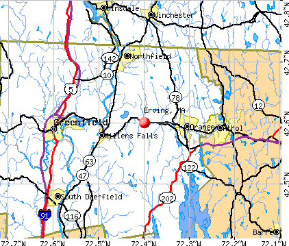
Notable locations in Erving: Erving Fire Department Station 2 (A), Erving Fire Department Station 1 (B), Erving Elementary School Library (C). Display/hide their locations on the map
Cemetery: Holton Cemetery (1). Display/hide its location on the map
Reservoirs and swamps: Northfield Mountain Reservoir (A), Laurel Lake (B), Spruce Swamp (C). Display/hide their locations on the map
Streams, rivers, and creeks: Osgood Brook (A), Millers River (B), Jacks Brook (C), Lyons Brook (D), Packard Brook (E), Schoolhouse Brook (F), Scots Brook (G). Display/hide their locations on the map
Drinking water stations with addresses in Erving and their reported violations in the past:
ERVING WATER DEPT (Population served: 560, Groundwater):Past health violations:Past monitoring violations:
- MCL, Monthly (TCR) - In JAN-2014, Contaminant: Coliform. Follow-up actions: St AO (w/o penalty) issued (JAN-27-2014)
- 3 regular monitoring violations
| This town: | 2.4 people |
| Massachusetts: | 2.5 people |
| This town: | 64.2% |
| Whole state: | 63.0% |
| This town: | 7.9% |
| Whole state: | 7.0% |
Likely homosexual households (counted as self-reported same-sex unmarried-partner households)
- Lesbian couples: 0.1% of all households
- Gay men: 0.0% of all households
| This town: | 6.7% |
| Whole state: | 9.3% |
| This town: | 3.2% |
| Whole state: | 4.4% |
For population 15 years and over in Erving:
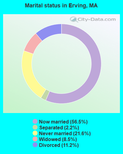
- Never married: 21.6%
- Now married: 56.5%
- Separated: 2.2%
- Widowed: 8.5%
- Divorced: 11.2%
For population 25 years and over in Erving:
- High school or higher: 84.5%
- Bachelor's degree or higher: 11.6%
- Graduate or professional degree: 3.3%
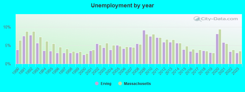
- Unemployed: 5.4%
- Mean travel time to work (commute): 22.6 minutes

| Here: | 8.1 |
| Massachusetts average: | 13.1 |


Graphs represent county-level data. Detailed 2008 Election Results
Religion statistics for Erving, MA (based on Franklin County data)


| Religion | Adherents | Congregations |
|---|---|---|
| Catholic | 16,509 | 15 |
| Mainline Protestant | 4,617 | 38 |
| Evangelical Protestant | 2,079 | 20 |
| Other | 1,580 | 21 |
| None | 46,587 | - |
Food Environment Statistics:
| This county: | 3.63 / 10,000 pop. |
| Massachusetts: | 1.98 / 10,000 pop. |
| Here: | 0.14 / 10,000 pop. |
| State: | 0.05 / 10,000 pop. |
| Franklin County: | 1.67 / 10,000 pop. |
| State: | 2.22 / 10,000 pop. |
| Franklin County: | 3.21 / 10,000 pop. |
| Massachusetts: | 1.77 / 10,000 pop. |
| This county: | 8.10 / 10,000 pop. |
| State: | 8.76 / 10,000 pop. |
| This county: | 7.5% |
| Massachusetts: | 8.1% |
| Franklin County: | 22.2% |
| Massachusetts: | 22.5% |
| Here: | 15.1% |
| Massachusetts: | 16.5% |
Strongest AM radio stations in Erving:
- WIZZ (1520 AM; daytime; 10 kW; GREENFIELD, MA; Owner: P. & M. RADIO, LLC)
- WNNZ (640 AM; 50 kW; WESTFIELD, MA; Owner: CLEAR CHANNEL BROADCASTING LICENSES, INC.)
- WCRN (830 AM; 50 kW; WORCESTER, MA; Owner: CARTER BROADCASTING CORPORATION)
- WCAT (700 AM; daytime; 2 kW; ORANGE-ATHOL, MA; Owner: CITADEL BROADCASTING COMPANY)
- WVNE (760 AM; daytime; 25 kW; LEICESTER, MA; Owner: BLOUNT MASSCOM, INC.)
- WRKO (680 AM; 50 kW; BOSTON, MA; Owner: ENTERCOM BOSTON LICENSE, LLC)
- WEEI (850 AM; 50 kW; BOSTON, MA; Owner: ENTERCOM BOSTON LICENSE, LLC)
- WKOX (1200 AM; 50 kW; FRAMINGHAM, MA; Owner: CAPSTAR TX LIMITED PARTNERSHIP)
- WTIC (1080 AM; 50 kW; HARTFORD, CT; Owner: INFINITY RADIO OPERATIONS INC.)
- WALE (990 AM; 50 kW; GREENVILLE, RI; Owner: NORTH AMERICAN BROADCASTING CO., INC.)
- WPNI (1430 AM; 5 kW; AMHERST, MA; Owner: WESTERN MASSACHUSETTS RADIO COMPANY)
- WBIX (1060 AM; 40 kW; NATICK, MA; Owner: LANGER BROADCASTING CORPORATION)
- WHMQ (1240 AM; 1 kW; GREENFIELD, MA; Owner: SAGA COMMUNICATIONS OF NEW ENGLAND, LLC)
Strongest FM radio stations in Erving:
- WJDF (97.3 FM; ORANGE, MA; Owner: DEANE BROTHERS BROADCASTING CORP.)
- WPVQ (95.3 FM; GREENFIELD, MA; Owner: GREAT NORTHERN RADIO, L.L.C.)
- WHAI (98.3 FM; GREENFIELD, MA; Owner: SAGA COMMUNICATIONS OF NEW ENGLAND, LLC)
- WYRY (104.9 FM; HINSDALE, NH; Owner: TRI-VALLEY BROADCASTING CORPORATION)
- WFCR (88.5 FM; AMHERST, MA; Owner: UNIVERSITY OF MASSACHUSETTS)
- WGAJ (91.7 FM; DEERFIELD, MA; Owner: TRUATEES OF DEERFIELD ACADEMY)
- WRSI (93.9 FM; TURNERS FALLS, MA; Owner: GREAT NORTHERN RADIO, LLC)
- WAMH (89.3 FM; AMHERST, MA; Owner: TRUSTEES OF AMHERST COLLEGE)
- WAMC-FM (90.3 FM; ALBANY, NY; Owner: WAMC)
- WOQL (98.7 FM; WINCHESTER, NH; Owner: SAGA COMMUNICATIONS OF NEW HAMPSHIRE, LLC)
- WVAY (100.7 FM; WILMINGTON, VT; Owner: GREAT NORTHERN RADIO, L.L.C.)
- WRSY (101.5 FM; MARLBORO, VT; Owner: GREAT NORTHERN RADIO, L.L.C.)
- WEQX (102.7 FM; MANCHESTER, VT; Owner: NORTHSHIRE COMMUNICATIONS, INC.)
- W246AM (97.1 FM; AMHERST, MA; Owner: GREAT NORTHERN RADIO, LLC)
- WHYN-FM (93.1 FM; SPRINGFIELD, MA; Owner: CLEAR CHANNEL BROADCASTING LICENSES, INC.)
- WJAN (95.1 FM; SUNDERLAND, VT; Owner: 6 JOHNSON ROAD LICENSES, INC.)
- WFEX (92.1 FM; PETERBOROUGH, NH; Owner: FNX BROADCASTING OF NEW HAMPSHIRE LLC)
- WAHL (99.9 FM; ATHOL, MA; Owner: CITADEL BROADCASTING COMPANY)
- WRNX (100.9 FM; AMHERST, MA; Owner: WESTERN MASSACHUSETTS RADIO COMPANY)
- WHDQ (106.1 FM; CLAREMONT, NH; Owner: GREAT NORTHERN RADIO, L.L.C.)
TV broadcast stations around Erving:
- WYDN (Channel 48; WORCESTER, MA; Owner: EDUCATIONAL PUBLIC TV CORPORATION)
- WUNI (Channel 27; WORCESTER, MA; Owner: ENTRAVISION HOLDINGS, LLC)
- WEKW-TV (Channel 52; KEENE, NH; Owner: UNIVERSITY OF NEW HAMPSHIRE)
- Erving, Massachusetts
- Fatal accident count23
- Vehicles involved in fatal accidents38
- Fatal accidents involving drunk persons:6
- Fatalities24
- Persons involved in fatal accidents48
- Pedestrians involved in fatal accidents0
- Massachusetts average
- Fatal accident count9755
- Vehicles involved in fatal accidents13470
- Fatal accidents involving drunk persons3244
- Fatalities10563
- Persons involved in fatal accidents22795
- Pedestrians involved in fatal accidents691
- National Bridge Inventory (NBI) Statistics
- 10Number of bridges
- 180ft / 54.7mTotal length
- $35,615,000Total costs
- 41,951Total average daily traffic
- 2,682Total average daily truck traffic
- 56,397Total future (year 2031) average daily traffic
- New bridges - historical statistics
- 1Before 1900
- 11910-1919
- 21930-1939
- 11940-1949
- 11950-1959
- 11980-1989
- 11990-1999
- 22000-2009
FCC Registered Antenna Towers:
20 (See the full list of FCC Registered Antenna Towers in Erving)FCC Registered Broadcast Land Mobile Towers:
11 (See the full list of FCC Registered Broadcast Land Mobile Towers in Erving, MA)FCC Registered Microwave Towers:
10 (See the full list of FCC Registered Microwave Towers in this town)FCC Registered Amateur Radio Licenses:
5- Call Sign: KA1SIA, Grant Date: 07/12/1999, Expiration Date: 07/12/2009, Cancellation Date: 07/13/2011, Registrant: Donald R Calkins, 12 North St, Erving, MA 01344-9724
- Call Sign: N1JWW, Grant Date: 09/29/1992, Expiration Date: 09/29/2002, Cancellation Date: 09/30/2004, Registrant: Mark W Mc Cord, 7 Wells St, Erving, MA 01344
- Call Sign: WB1HKN, Grant Date: 11/07/1995, Expiration Date: 11/07/2005, Cancellation Date: 11/08/2007, Registrant: Richard F Cunningham, 46 High St, Erving, MA 01344
- Call Sign: KB1FVW, Licensee ID: L00295883, Grant Date: 10/25/2010, Expiration Date: 11/02/2020, Cancellation Date: 11/03/2022, Certifier: Joseph A Bassett, Registrant: Joseph A Bassett, 5 Pleasant St, Erving, MA 01344
- Call Sign: KB1PKK, Licensee ID: L01319403, Grant Date: 08/30/2007, Expiration Date: 08/30/2017, Cancellation Date: 08/31/2019, Certifier: Aaron D Budine, Registrant: Aaron D Budine, 41 Forest St, Erving, MA 01344
2002 - 2018 National Fire Incident Reporting System (NFIRS) incidents
- Fire incident types reported to NFIRS in Erving, MA
- 11447.9%Structure Fires
- 8837.0%Outside Fires
- 2811.8%Other
- 83.4%Mobile Property/Vehicle Fires
 Based on the data from the years 2002 - 2018 the average number of fires per year is 14. The highest number of fire incidents - 31 took place in 2005, and the least - 0 in 2003. The data has a growing trend.
 When looking into fire subcategories, the most reports belonged to: Structure Fires (47.9%), and Outside Fires (37.0%).
- 77.1%Fuel oil, kerosene, etc.
- 9.5%Wood
- 6.5%Bottled, tank, or LP gas
- 6.1%Electricity
- 0.4%Utility gas
- 0.2%Coal or coke
- 0.2%Solar energy
- 52.4%Fuel oil, kerosene, etc.
- 25.4%Electricity
- 22.2%Bottled, tank, or LP gas
Erving compared to Massachusetts state average:
- Median house value below state average.
- Unemployed percentage below state average.
- Black race population percentage significantly below state average.
- Hispanic race population percentage significantly below state average.
- Foreign-born population percentage significantly below state average.
- Renting percentage below state average.
- Length of stay since moving in significantly above state average.
- Number of rooms per house significantly below state average.
- House age significantly below state average.
- Number of college students below state average.
- Percentage of population with a bachelor's degree or higher significantly below state average.

|
Total of 1 patent application in 2008-2024.