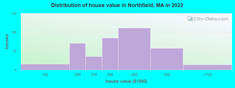
Estimated median house or condo value in 2022: $290,125 (it was $128,500 in 2000)
Northfield:
$290,125
MA:
$534,700
Mean prices in 2022:all housing units: $313,377; detached houses: $324,224; townhouses or other attached units: $284,225; in 2-unit structures: $287,978; in 3-to-4-unit structures: $183,938; in 5-or-more-unit structures: $249,762; mobile homes: $62,200
Median gross rent in 2022: $823.
March 2022 cost of living index in Northfield: 87.1 (less than average, U.S. average is 100)
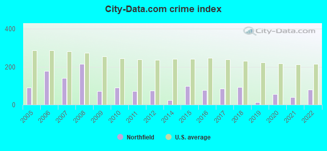
The City-Data.com crime index weighs serious crimes and violent crimes more heavily. Higher means more crime, U.S. average is 246.1. It adjusts for the number of visitors and daily workers commuting into cities.
Latest news from Northfield, MA collected exclusively by city-data.com from local newspapers, TV, and radio stations
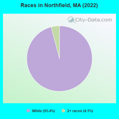
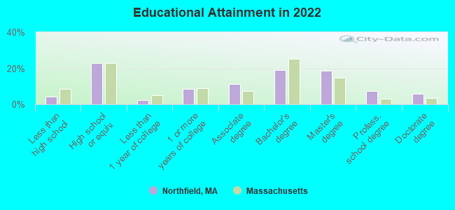
Ancestries: English (27.4%), Polish (13.1%), French Canadian (10.1%), Swedish (8.9%), European (6.0%), Portuguese (6.0%).
Current Local Time: EST time zone
Incorporated in 1723
Elevation: 300 feet
Land area: 4.47 square miles.
Population density: 244 people per square mile (very low).
20 residents are foreign born
This place:
1.8%
Massachusetts:
12.2%
Median real estate property taxes paid for housing units with mortgages in 2022: $3,603 (1.3%) Median real estate property taxes paid for housing units with no mortgage in 2022: $4,005 (1.1%)
Nearest city with pop. 50,000+: Chicopee, MA (37.7 miles , pop. 54,653).
Nearest city with pop. 200,000+: Boston, MA (74.0 miles , pop. 589,141).
Nearest city with pop. 1,000,000+: Bronx, NY (148.1 miles , pop. 1,332,650).
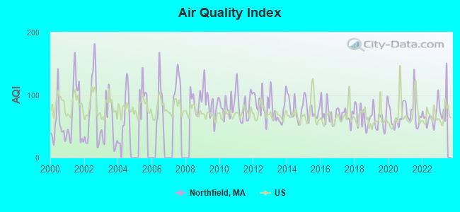
Air Quality Index (AQI) level in 2022 was 65.9. This is about average.
City:
65.9
U.S.:
72.6
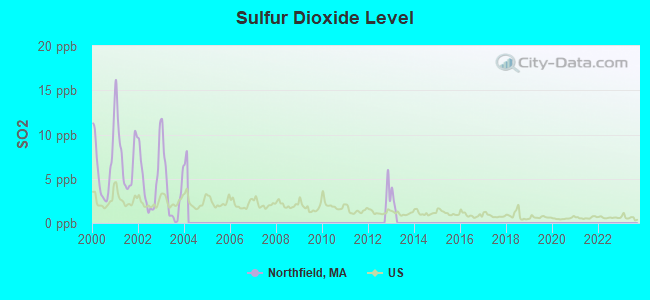
Sulfur Dioxide (SO2) [ppb] level in 2003 was 3.66. This is significantly worse than average.Closest monitor was 7.6 miles away from the city center.
City:
3.66
U.S.:
1.51
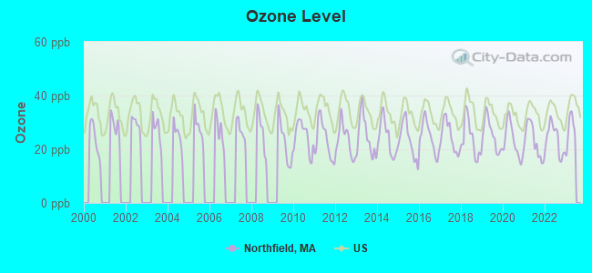
Ozone [ppb] level in 2022 was 23.7. This is significantly better than average.Closest monitor was 10.3 miles away from the city center.
City:
23.7
U.S.:
33.3
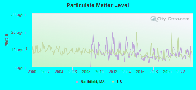
Particulate Matter (PM2.5) [µg/m3] level in 2022 was 6.96. This is about average.Closest monitor was 10.3 miles away from the city center.
City:
6.96
U.S.:
8.11
Tornado activity:
Northfield-area historical tornado activity is slightly above Massachusetts state average. It is 16% smaller than the overall U.S. average.
On 6/9/1953, a category F4 (max. wind speeds 207-260 mph) tornado 21.4 miles away from the Northfield place center killed 90 peopleand injured 1228 peopleand causedbetween $50,000,000 and $500,000,000 in damages.
On 6/22/1981, a category F3 (max. wind speeds 158-206 mph) tornado 25.4 miles away from the place center injured 3 peopleand causedbetween $5000 and $50,000 in damages.
Earthquake activity:
Northfield-area historical earthquake activity is significantly above Massachusetts state average. It is 70% smaller than the overall U.S. average.
On 10/7/1983 at 10:18:46, a magnitude 5.3 (5.1 MB, 5.3 LG, 5.1 ML, Class: Moderate, Intensity: VI - VII) earthquake occurred 128.7 miles away from the city center On 4/20/2002 at 10:50:47, a magnitude 5.3 (5.3 ML, Depth: 3.0 mi) earthquake occurred 139.9 miles away from the city center On 4/20/2002 at 10:50:47, a magnitude 5.2 (5.2 MB, 4.2 MS, 5.2 MW, 5.0 MW) earthquake occurred 138.8 miles away from Northfield center On 1/19/1982 at 00:14:42, a magnitude 4.7 (4.5 MB, 4.7 MD, 4.5 LG, Class: Light, Intensity: IV - V) earthquake occurred 69.6 miles away from the city center On 10/16/2012 at 23:12:25, a magnitude 4.7 (4.7 ML, Depth: 10.0 mi) earthquake occurred 109.3 miles away from the city center On 10/2/1994 at 11:27:22, a magnitude 3.7 (3.5 LG, 3.7 LG, Depth: 6.2 mi, Class: Light, Intensity: II - III) earthquake occurred 26.2 miles away from Northfield center Magnitude types: regional Lg-wave magnitude (LG), body-wave magnitude (MB), duration magnitude (MD), local magnitude (ML), surface-wave magnitude (MS), moment magnitude (MW)
Natural disasters:
The number of natural disasters in Franklin County (20) is greater than the US average (15). Major Disasters (Presidential) Declared: 9 Emergencies Declared: 10
Causes of natural disasters: Floods: 5, Storms: 5, Hurricanes: 4, Snowstorms: 4, Winter Storms: 3, Blizzards: 2, Snows: 2, Snowfall: 1, Tropical Storm: 1, Wind: 1, Other: 1 (Note: some incidents may be assigned to more than one category).
Hospitals and medical centers near Northfield:
APPLEWOOD CARE AND REHABILITATION CENTER (Nursing Home, about 5 miles away; WINCHESTER, NH)
VERNON GREEN NURSING HOME (Nursing Home, about 6 miles away; VERNON, VT)
NURSE'S HOUSE CALL - GREENFIELD (Home Health Center, about 10 miles away; GREENFIELD, MA)
YANKEE FAMILY DIALYSIS CENTER (Dialysis Facility, about 10 miles away; GREENFIELD, MA)
POET'S SEAT HEALTH CARE CENTER (Nursing Home, about 10 miles away; GREENFIELD, MA)
BAYSTATE FRANKLIN MEDICAL CENTER Acute Care Hospitals (about 11 miles away; GREENFIELD, MA)
HOSPICE OF FRANKLIN COUNTY (Hospital, about 11 miles away; GREENFIELD, MA)
Amtrak station near Northfield:
11 miles: BRATTLEBORO (VERNON RD.) . Services: enclosed waiting area, public restrooms, call for car rental service, call for taxi service.
Operable nuclear power plant near Northfield:
6 miles: Vermont Yankee in Vernon, VT.
Colleges/universities with over 2000 students nearest to Northfield:
Keene State College (about 18 miles; Keene, NH; Full-time enrollment: 5,098)
Franklin Pierce University (about 21 miles; Rindge, NH; FT enrollment: 2,139)
University of Massachusetts-Amherst (about 23 miles; Amherst, MA; FT enrollment: 26,583)
Mount Wachusett Community College (about 25 miles; Gardner, MA; FT enrollment: 3,143)
Smith College (about 29 miles; Northampton, MA; FT enrollment: 3,549)
Mount Holyoke College (about 32 miles; South Hadley, MA; FT enrollment: 2,573)
Fitchburg State University (about 35 miles; Fitchburg, MA; FT enrollment: 5,010)
DICKINSON MEMORIAL LIBRARY (Operating income: $132,408; Location: 115 MAIN STREET; 16,261 books; 930 e-books; 2,357 audio materials; 2,008 video materials; 7 local licensed databases; 30 state licensed databases; 50 print serial subscriptions)
FIELD LIBRARY (Operating income: $1,988; Location: 243 MILLERS FALLS ROAD; 9,685 books; 77 audio materials; 468 video materials; 2 print serial subscriptions)
User-submitted facts and corrections:
Northfield Mount HErmo is grades 9 through 12 with a PG year. It is now only on one campus in Gill, rather than 2 campuses, with one also in Northfield.
Churches in Northfield include: Unitarian Universalist Church (A), Trinitarian Congregational Church (B), Northfield Baptist Church (C). Display/hide their locations on the map
Tourist attraction: C W Mars (Cultural Attractions- Events- & Facilities; 243 Millers Falls Road).
Birthplace of: Dwight L. Moody - Evangelist and publisher who founded the Moody Church.
Franklin County has a predicted average indoor radon screening level between 2 and 4 pCi/L (pico curies per liter) - Moderate Potential
Drinking water stations with addresses in Northfield and their reported violations in the past:
NORTHFIELD WATER DISTRICT (Population served: 890, Groundwater):
Past health violations:
MCL, Monthly (TCR) - In DEC-2012, Contaminant: Coliform. Follow-up actions: St AO (w/o penalty) issued (JAN-25-2013)
MCL, Monthly (TCR) - In JAN-2011, Contaminant: Coliform. Follow-up actions: St AO (w/o penalty) issued (FEB-11-2011)
MCL, Monthly (TCR) - In NOV-2009, Contaminant: Coliform. Follow-up actions: St AO (w/o penalty) issued (JAN-19-2010)
Past monitoring violations:
2 minor monitoring violations
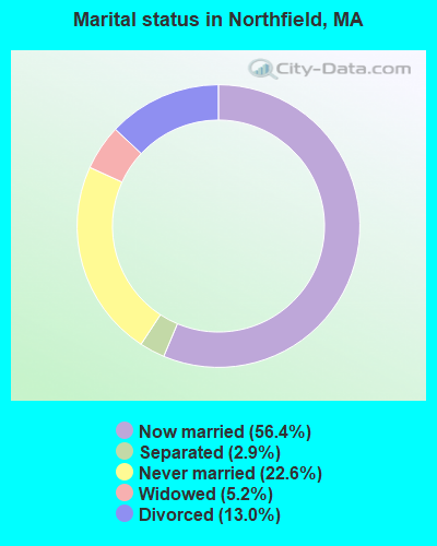
Average household size:
This place:
2.2 people
Massachusetts:
2.5 people
Percentage of family households:
This place:
61.1%
Whole state:
63.0%
Percentage of households with unmarried partners:
This place:
9.9%
Whole state:
7.0%
Likely homosexual households (counted as self-reported same-sex unmarried-partner households)
Lesbian couples: 0.6% of all households
Gay men: 0.4% of all households
Banks with branches in Northfield (2011 data):
Greenfield Co-operative Bank: Northfield Branch at 144 Main Street, branch established on 1975/05/19. Info updated 2008/12/09: Bank assets: $308.4 mil, Deposits: $260.0 mil, headquarters in Greenfield, MA, positive income, Mortgage Lending Specialization, 5 total offices, Holding Company: Greenfield Bancorp Mhc
Religion statistics for Northfield, MA (based on Franklin County data)
Religion
Adherents
Congregations
Catholic
16,509
15
Mainline Protestant
4,617
38
Evangelical Protestant
2,079
20
Other
1,580
21
None
46,587
-
Source: Clifford Grammich, Kirk Hadaway, Richard Houseal, Dale E.Jones, Alexei Krindatch, Richie Stanley and Richard H.Taylor. 2012. 2010 U.S.Religion Census: Religious Congregations & Membership Study. Association of Statisticians of American Religious Bodies. Jones, Dale E., et al. 2002. Congregations and Membership in the United States 2000. Nashville, TN: Glenmary Research Center. Graphs represent county-level data
Rt 63 - Northfield Mtn., 6 Miles South Of (Lat: 42.608500 Lon: -72.449250), Type: Tower, Structure height: 27.4 m, Overall height: 28.6 m, Call Sign: KNKN860 Assigned Frequencies: 869.040 MHz, 869.040 MHz, 869.040 MHz, 824.040 MHz, 824.040 MHz, 824.040 MHz, 890.010 MHz, 890.010 MHz, 890.010 MHz, 845.010 MHz, 845.010 MHz, 845.010 MHzGrant Date: 08/31/2021, Expiration Date: 10/01/2031, Certifier: John T Scott IiiRegistrant: Verizon Wireless, 5055 North Point Pkwy, Np2ne Network Engineering, Alpharetta, GA 30022, Phone: (770) 797-1070, Fax: (770) 797-1036, Email:
FCC Registered Broadcast Land Mobile Towers:
5
Corner Of Main & School St (Lat: 42.697583 Lon: -72.433972), Call Sign: KNIT474, Licensee ID: L00043690, Assigned Frequencies: 46.5200 MHz, Grant Date: 03/26/1999, Expiration Date: 05/19/2004, Cancellation Date: 07/25/2004, Registrant: Northfield, Town Of, Main St, Northfield, MA 01360, Phone: (413) 498-5521
Town Hall Main St Jct Of Warwick Ave (Lat: 42.706750 Lon: -72.441194), Call Sign: KRG723, Licensee ID: L01905380, Assigned Frequencies: 39.1600 MHz, 39.2400 MHz, Grant Date: 01/26/2005, Expiration Date: 02/01/2015, Cancellation Date: 04/04/2015, Registrant: Northfield, Town Of, 69 Main St, Northfield, MA 01360, Phone: (413) 498-2901
97 F Sumner Turner Drive (Lat: 42.683139 Lon: -72.484806), Type: Bant, Structure height: 9 m, Overall height: 14 m, Call Sign: WPJM562, Assigned Frequencies: 152.420 MHz, Grant Date: 07/21/2021, Expiration Date: 07/29/2031, Certifier: Robert W Englehardt, Registrant: Business Radio Licensing, 30251 Golden Lantern, Suite E #501, Laguna Niguel, CA 92677, Phone: (949) 348-8510, Fax: (949) 348-8514, Email:
Corner Of Main & School St (Lat: 42.697583 Lon: -72.433972), Type: Bant, Structure height: 21 m, Call Sign: WQCK977, Licensee ID: L01905380, Assigned Frequencies: 46.5200 MHz, Grant Date: 02/12/2015, Expiration Date: 03/29/2025, Certifier: Susan J Draves, Registrant: Northfield, Town Of, Main St, Northfield, MA 01360, Phone: (413) 498-5521
Aircraft: GRAVELINE JOSEPH P CH-2 (Category: Land, Seats: 2, Weight: Up to 12,499 Pounds), Engine: AMA/EXPR UNKNOWN ENG (Reciprocating) N-Number: 3118G, N3118G, N-3118G, Serial Number: CH20191-0607, Year manufactured: 1991, Airworthiness Date: 04/26/1993, Certificate Issue Date: 09/19/1991 Registrant (Individual): Joseph P Graveline, 67 Route 10, Northfield, MA 01360
Aircraft: AUTO GYRO GMBH MTOSPORT (Category: Land, Seats: 2, Weight: Up to 12,499 Pounds), Engine: ROTAX 914UL (115 HP) (Reciprocating) N-Number: 320QT, N320QT, N-320QT, Serial Number: M01425, Year manufactured: 2017, Airworthiness Date: 12/21/2017, Certificate Issue Date: 09/20/2018 Registrant (Individual): James Antes, 280 Old Vernon Rd, Northfield, MA 01360
Aircraft: CESSNA 182H (Category: Land, Seats: 4, Weight: Up to 12,499 Pounds, Speed: 119 mph), Engine: CONT MOTOR O-470 SERIES (230 HP) (Reciprocating) N-Number: 8343S, N8343S, N-8343S, Serial Number: 18256443, Year manufactured: 1965, Airworthiness Date: 07/01/1965, Certificate Issue Date: 11/28/2017 Registrant (Individual): Jon G Mcgowan, 134 Main St, Northfield, MA 01360
Aircraft: PIPER PA-28R-201T (Category: Land, Seats: 4, Weight: Up to 12,499 Pounds, Speed: 108 mph), Engine: CONT MOTOR TSIO-360 SER (225 HP) (Reciprocating) N-Number: 9011C, N9011C, N-9011C, Serial Number: 28R-7803243, Airworthiness Date: 02/24/1978, Certificate Issue Date: 08/03/2020 Registrant (Individual): Vasilios Parios, 198 Main St, Northfield, MA 01360
Aircraft: PIPER PA-24-260 (Category: Land, Seats: 4, Weight: Up to 12,499 Pounds, Speed: 135 mph), Engine: LYCOMING TI0-540 SER (310 HP) (Reciprocating) N-Number: 9488P, N9488P, N-9488P, Serial Number: 24-5004, Year manufactured: 1971, Airworthiness Date: 10/14/1971, Certificate Issue Date: 08/06/2014 Registrant (Individual): James H Antes, 280 Old Vernon Rd, Northfield, MA 01360
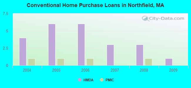
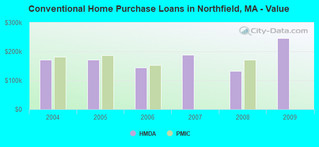
Home Mortgage Disclosure Act Aggregated Statistics For Year 2009 (Based on 1 partial tract)
B) Conventional Home Purchase Loans
C) Refinancings
D) Home Improvement Loans
F) Non-occupant Loans on < 5 Family Dwellings (A B C & D)
Number
Average Value
Number
Average Value
Number
Average Value
Number
Average Value
LOANS ORIGINATED
1
$246,040
12
$152,970
1
$71,980
1
$71,220
APPLICATIONS APPROVED, NOT ACCEPTED
0
$0
2
$142,500
0
$0
0
$0
APPLICATIONS DENIED
0
$0
3
$188,737
1
$78,810
0
$0
APPLICATIONS WITHDRAWN
0
$0
2
$133,835
0
$0
0
$0
FILES CLOSED FOR INCOMPLETENESS
0
$0
0
$0
0
$0
0
$0
Aggregated Statistics For Year 2008 (Based on 1 partial tract)
B) Conventional Home Purchase Loans
C) Refinancings
D) Home Improvement Loans
F) Non-occupant Loans on < 5 Family Dwellings (A B C & D)
Number
Average Value
Number
Average Value
Number
Average Value
Number
Average Value
LOANS ORIGINATED
3
$132,950
6
$142,608
2
$78,240
1
$69,830
APPLICATIONS APPROVED, NOT ACCEPTED
0
$0
1
$146,740
0
$0
0
$0
APPLICATIONS DENIED
0
$0
2
$173,495
1
$91,080
0
$0
APPLICATIONS WITHDRAWN
0
$0
0
$0
0
$0
0
$0
FILES CLOSED FOR INCOMPLETENESS
0
$0
0
$0
0
$0
0
$0
Aggregated Statistics For Year 2007 (Based on 1 partial tract)
B) Conventional Home Purchase Loans
C) Refinancings
D) Home Improvement Loans
F) Non-occupant Loans on < 5 Family Dwellings (A B C & D)
Number
Average Value
Number
Average Value
Number
Average Value
Number
Average Value
LOANS ORIGINATED
3
$187,767
6
$156,375
2
$47,185
1
$95,380
APPLICATIONS APPROVED, NOT ACCEPTED
0
$0
2
$146,295
0
$0
0
$0
APPLICATIONS DENIED
1
$98,540
5
$212,774
1
$39,720
1
$126,750
APPLICATIONS WITHDRAWN
0
$0
2
$156,225
0
$0
0
$0
FILES CLOSED FOR INCOMPLETENESS
0
$0
1
$140,410
0
$0
0
$0
Aggregated Statistics For Year 2006 (Based on 1 partial tract)
B) Conventional Home Purchase Loans
C) Refinancings
D) Home Improvement Loans
F) Non-occupant Loans on < 5 Family Dwellings (A B C & D)
Number
Average Value
Number
Average Value
Number
Average Value
Number
Average Value
LOANS ORIGINATED
6
$144,632
10
$163,021
4
$58,475
1
$97,530
APPLICATIONS APPROVED, NOT ACCEPTED
0
$0
2
$115,305
0
$0
0
$0
APPLICATIONS DENIED
1
$144,840
4
$167,645
3
$80,287
0
$0
APPLICATIONS WITHDRAWN
0
$0
4
$197,340
0
$0
0
$0
FILES CLOSED FOR INCOMPLETENESS
0
$0
1
$89,940
0
$0
0
$0
Aggregated Statistics For Year 2005 (Based on 1 partial tract)
B) Conventional Home Purchase Loans
C) Refinancings
D) Home Improvement Loans
F) Non-occupant Loans on < 5 Family Dwellings (A B C & D)
Number
Average Value
Number
Average Value
Number
Average Value
Number
Average Value
LOANS ORIGINATED
6
$170,648
13
$140,182
4
$71,758
1
$131,430
APPLICATIONS APPROVED, NOT ACCEPTED
1
$172,420
2
$239,340
0
$0
0
$0
APPLICATIONS DENIED
2
$104,235
8
$160,529
2
$95,380
1
$28,210
APPLICATIONS WITHDRAWN
1
$125,740
6
$156,882
1
$93,230
0
$0
FILES CLOSED FOR INCOMPLETENESS
0
$0
1
$234,530
0
$0
0
$0
Aggregated Statistics For Year 2004 (Based on 1 partial tract)
B) Conventional Home Purchase Loans
C) Refinancings
D) Home Improvement Loans
F) Non-occupant Loans on < 5 Family Dwellings (A B C & D)
Detailed PMIC statistics for the following Tracts:0403.00
2004 - 2018 National Fire Incident Reporting System (NFIRS) incidents
Based on the data from the years 2004 - 2018 the average number of fire incidents per year is 10. The highest number of reported fires - 27 took place in 2016, and the least - 0 in 2007. The data has a constant trend.
When looking into fire subcategories, the most incidents belonged to: Structure Fires (56.1%), and Outside Fires (32.3%).
Fire incident types reported to NFIRS in Northfield, MA


 Recent articles from our blog. Our writers, many of them Ph.D. graduates or candidates, create easy-to-read articles on a wide variety of topics.


 (37.7 miles


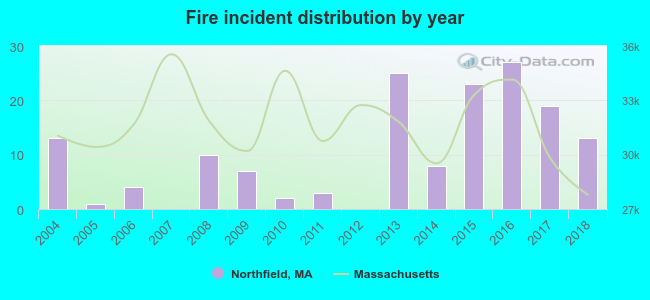 Based on the data from the years 2004 - 2018 the average number of fire incidents per year is 10. The highest number of reported fires - 27 took place in 2016, and the least - 0 in 2007. The data has a constant trend.
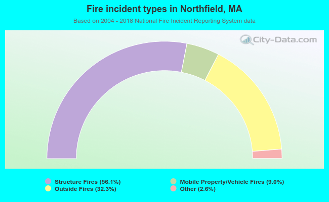 When looking into fire subcategories, the most incidents belonged to: Structure Fires (56.1%), and Outside Fires (32.3%).