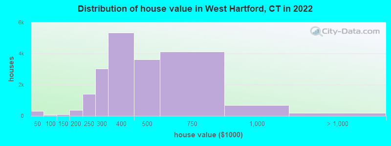
Estimated median house or condo value in 2022: $397,398 (it was $172,300 in 2000)
West Hartford:
$397,398
CT:
$347,200
Mean prices in 2022:all housing units: $417,504; detached houses: $433,362; townhouses or other attached units: $281,313; in 2-unit structures: $375,241; in 3-to-4-unit structures: $119,108; in 5-or-more-unit structures: $286,081
Median gross rent in 2022: $1,591.
March 2022 cost of living index in West Hartford: 105.4 (more than average, U.S. average is 100)
Percentage of residents living in poverty in 2022: 5.9%
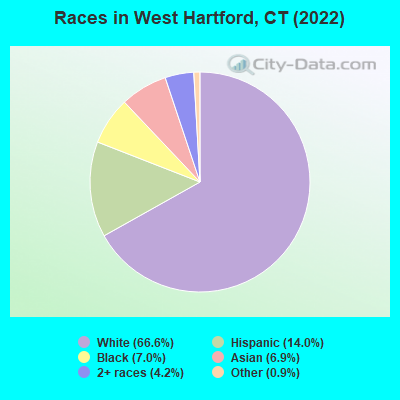
(4.5% for White Non-Hispanic residents, 14.5% for Black residents, 11.2% for Hispanic or Latino residents, 7.2% for other race residents, 7.2% for two or more races residents)
According to our research of Connecticut and other state lists, there were 14 registered sex offenders living in West Hartford, Connecticut as of April 27, 2024. The ratio of all residents to sex offenders in West Hartford is 4,497 to 1. The ratio of registered sex offenders to all residents in this city is much lower than the state average.
Crime rates in West Hartford by year
Type
2009
2010
2011
2012
2013
2014
2015
2016
2017
2018
2019
2020
2021
2022
Murders (per 100,000)
1 (1.7)
1 (1.6)
1 (1.6)
0 (0.0)
0 (0.0)
1 (1.6)
0 (0.0)
0 (0.0)
0 (0.0)
1 (1.6)
0 (0.0)
0 (0.0)
1 (1.6)
0 (0.0)
Rapes (per 100,000)
6 (9.9)
2 (3.2)
4 (6.3)
2 (3.2)
2 (3.2)
1 (1.6)
2 (3.2)
2 (3.2)
1 (1.6)
2 (3.2)
1 (1.6)
4 (6.4)
0 (0.0)
2 (3.1)
Robberies (per 100,000)
40 (66.2)
44 (69.5)
46 (72.6)
35 (55.1)
35 (55.3)
38 (60.0)
46 (72.7)
39 (61.9)
61 (97.1)
41 (65.0)
31 (49.3)
23 (36.6)
41 (65.3)
27 (42.2)
Assaults (per 100,000)
37 (61.2)
14 (22.1)
17 (26.8)
9 (14.2)
8 (12.6)
10 (15.8)
8 (12.6)
0 (0.0)
5 (8.0)
1 (1.6)
5 (8.0)
4 (6.4)
5 (8.0)
9 (14.1)
Burglaries (per 100,000)
293 (484.9)
210 (331.9)
233 (367.6)
243 (382.8)
177 (279.7)
200 (315.7)
156 (246.4)
131 (208.0)
150 (238.8)
196 (310.7)
130 (206.8)
173 (275.0)
141 (224.5)
105 (164.2)
Thefts (per 100,000)
1,324 (2,191)
1,191 (1,882)
1,182 (1,865)
1,349 (2,125)
1,122 (1,773)
1,133 (1,788)
1,206 (1,905)
1,352 (2,147)
1,591 (2,533)
1,411 (2,237)
1,198 (1,905)
1,424 (2,264)
1,357 (2,161)
1,519 (2,376)
Auto thefts (per 100,000)
87 (144.0)
65 (102.7)
106 (167.2)
104 (163.8)
83 (131.2)
66 (104.2)
111 (175.4)
107 (169.9)
121 (192.6)
138 (218.8)
84 (133.6)
125 (198.7)
89 (141.7)
77 (120.4)
Arson (per 100,000)
2 (3.3)
0 (0.0)
1 (1.6)
2 (3.2)
0 (0.0)
0 (0.0)
0 (0.0)
2 (3.2)
5 (8.0)
1 (1.6)
1 (1.6)
0 (0.0)
0 (0.0)
0 (0.0)
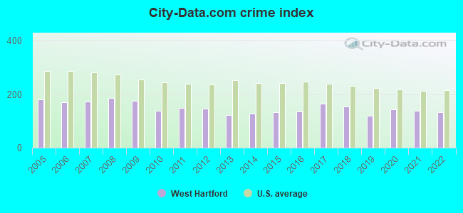
City-Data.com crime index
176.5
137.7
149.0
146.8
122.7
127.5
134.3
135.1
165.4
154.2
119.0
143.0
137.8
134.2
The City-Data.com crime index weighs serious crimes and violent crimes more heavily. Higher means more crime, U.S. average is 246.1. It adjusts for the number of visitors and daily workers commuting into cities.
- means the value is smaller than the state average. - means the value is about the same as the state average. - means the value is bigger than the state average. - means the value is much bigger than the state average.
Ancestries: Irish (8.0%), Italian (6.4%), American (5.3%), English (3.8%), Polish (3.6%), German (3.4%).
Current Local Time: EST time zone
Incorporated on 05/1854
Elevation: 136 feet
Land area: 22.0 square miles.
Population density: 2,878 people per square mile (average).
11,677 residents are foreign born (5.9% Latin America, 5.7% Asia, 4.8% Europe).
This place:
18.1%
Connecticut:
15.0%
Median real estate property taxes paid for housing units with mortgages in 2022: $8,876 (2.2%) Median real estate property taxes paid for housing units with no mortgage in 2022: $8,603 (2.3%)
Nearest city with pop. 200,000+: North Hempstead, NY (83.2 miles , pop. 222,611).
Nearest city with pop. 1,000,000+: Bronx, NY (86.2 miles , pop. 1,332,650).
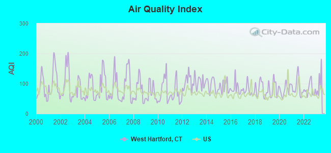
Air Quality Index (AQI) level in 2022 was 81.4. This is about average.
City:
81.4
U.S.:
72.6
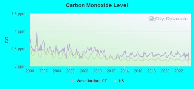
Carbon Monoxide (CO) [ppm] level in 2022 was 0.312. This is worse than average.Closest monitor was 2.2 miles away from the city center.
City:
0.312
U.S.:
0.251
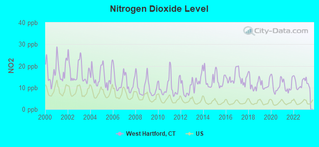
Nitrogen Dioxide (NO2) [ppb] level in 2022 was 11.9. This is significantly worse than average.Closest monitor was 3.2 miles away from the city center.
City:
11.9
U.S.:
5.1
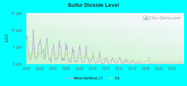
Sulfur Dioxide (SO2) [ppb] level in 2016 was 0.389. This is significantly better than average.Closest monitor was 3.2 miles away from the city center.
City:
0.389
U.S.:
1.515
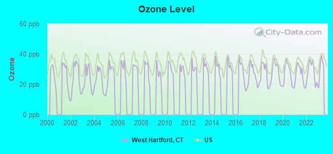
Ozone [ppb] level in 2022 was 28.0. This is about average.Closest monitor was 3.2 miles away from the city center.
City:
28.0
U.S.:
33.3
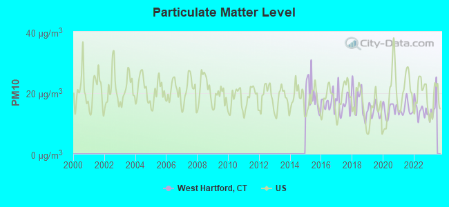
Particulate Matter (PM10) [µg/m3] level in 2022 was 14.3. This is better than average.Closest monitor was 2.2 miles away from the city center.
City:
14.3
U.S.:
19.2
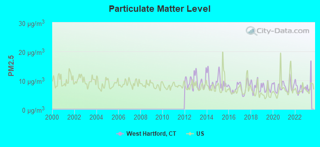
Particulate Matter (PM2.5) [µg/m3] level in 2022 was 7.33. This is about average.Closest monitor was 3.4 miles away from the city center.
City:
7.33
U.S.:
8.11
Tornado activity:
West Hartford-area historical tornado activity is slightly above Connecticut state average. It is 18% smaller than the overall U.S. average.
On 10/3/1979, a category F4 (max. wind speeds 207-260 mph) tornado 9.1 miles away from the West Hartford place center killed 3 peopleand injured 500 peopleand causedbetween $50,000,000 and $500,000,000 in damages.
On 7/10/1989, a category F4 tornado 27.5 miles away from the place center injured 40 peopleand causedbetween $50,000,000 and $500,000,000 in damages.
Earthquake activity:
West Hartford-area historical earthquake activity is significantly above Connecticut state average. It is 70% smaller than the overall U.S. average.
On 10/7/1983 at 10:18:46, a magnitude 5.3 (5.1 MB, 5.3 LG, 5.1 ML, Class: Moderate, Intensity: VI - VII) earthquake occurred 172.0 miles away from the city center On 4/20/2002 at 10:50:47, a magnitude 5.3 (5.3 ML, Depth: 3.0 mi) earthquake occurred 196.4 miles away from the city center On 4/20/2002 at 10:50:47, a magnitude 5.2 (5.2 MB, 4.2 MS, 5.2 MW, 5.0 MW) earthquake occurred 194.9 miles away from West Hartford center On 1/19/1982 at 00:14:42, a magnitude 4.7 (4.5 MB, 4.7 MD, 4.5 LG, Class: Light, Intensity: IV - V) earthquake occurred 133.7 miles away from the city center On 10/16/2012 at 23:12:25, a magnitude 4.7 (4.7 ML, Depth: 10.0 mi) earthquake occurred 165.6 miles away from West Hartford center On 8/23/2011 at 17:51:04, a magnitude 5.8 (5.8 MW, Depth: 3.7 mi) earthquake occurred 383.3 miles away from the city center Magnitude types: regional Lg-wave magnitude (LG), body-wave magnitude (MB), duration magnitude (MD), local magnitude (ML), surface-wave magnitude (MS), moment magnitude (MW)
Natural disasters:
The number of natural disasters in Hartford County (24) is greater than the US average (15). Major Disasters (Presidential) Declared: 13 Emergencies Declared: 11
Causes of natural disasters: Storms: 7, Hurricanes: 5, Floods: 4, Snowstorms: 4, Blizzards: 3, Snows: 3, Tropical Storms: 2, Winter Storms: 2, Snowfall: 1, Tornado: 1, Wind: 1 (Note: some incidents may be assigned to more than one category).
Hospitals in West Hartford:
C I B: BURNHAM RD COMM RES (88 BURNHAM RD)
HEBREW HOME AND HOSPITAL INC (Voluntary non-profit - Private, 1 ABRAHMS BOULEVARD)
Home Health Centers in West Hartford:
ADVANCED HOME HEALTH CARE AGENCY, INC (104 PARK ROAD)
AMERICAN HOME HEALTH, INC (485 NEW PARK AVENUE)
MERCY COMMUNITY HOME CARE SERV (275 STEELE ROAD)
Nursing Homes in West Hartford:
BROOKVIEW ICF (130 LOOMIS DR)
HEBREW HOME AND HOSPITAL INC (1 ABRAHMS BLVD)
HUGHES HEALTH AND REHABILITATI (29 HIGHLAND ST)
RESERVOIR CARE AND REHABILITATION CENTER, THE (1 EMILY WAY)
ST MARY HOME (2021 ALBANY AVE)
WEST HARTFORD HEALTH AND REHABILITATION CENTER (130 LOOMIS DR)
Amtrak stations near West Hartford:
4 miles: HARTFORD (1 UNION PLACE) . Services: ticket office, partially wheelchair accessible, enclosed waiting area, public restrooms, public payphones, full-service food facilities, snack bar, vending machines, ATM, paid short-term parking, paid long-term parking, call for car rental service, taxi stand, intercity bus service, public transit connection.
9 miles: WINDSOR (41 CENTRAL ST.) . Services: enclosed waiting area, public restrooms, public payphones, free short-term parking, call for car rental service, call for taxi service, public transit connection.
9 miles: BERLIN (KENSINGTON, DEPOT RD.) . Services: ticket office, partially wheelchair accessible, enclosed waiting area, public restrooms, public payphones, free short-term parking, free long-term parking, call for car rental service, call for taxi service, public transit connection.
Colleges/Universities in West Hartford:
University of Hartford (Full-time enrollment: 6,398; Location: 200 Bloomfield Ave; Private, not-for-profit; Website: www.hartford.edu; Offers Doctor's degree)
University of Saint Joseph (Full-time enrollment: 1,790; Location: 1678 Asylum Avenue; Private, not-for-profit; Website: www.usj.edu; Offers Doctor's degree)
Fox Institute of Business-West Hartford (Full-time enrollment: 307; Location: 99 South Street; Private, for-profit; Website: americaninstitute.edu)
Other colleges/universities with over 2000 students near West Hartford:
Trinity College (about 3 miles; Hartford, CT; Full-time enrollment: 2,355)
Capital Community College (about 4 miles; Hartford, CT; FT enrollment: 2,609)
Central Connecticut State University (about 6 miles; New Britain, CT; FT enrollment: 9,989)
Goodwin College (about 6 miles; East Hartford, CT; FT enrollment: 3,017)
Tunxis Community College (about 8 miles; Farmington, CT; FT enrollment: 2,787)
Manchester Community College (about 10 miles; Manchester, CT; FT enrollment: 4,667)
Wesleyan University (about 15 miles; Middletown, CT; FT enrollment: 3,517)
Public high schools in West Hartford:
HALL HIGH SCHOOL(Students: 1,221, Location: 975 NORTH MAIN STREET, Grades: 9-12)
CONARD HIGH SCHOOL(Students: 1,096, Location: 110 BEECHWOOD ROAD, Grades: 9-12)
WEST HARTFORD PUBLIC LIBRARY (Operating income: $3,692,023; Location: 20 SOUTH MAIN ST.; 212,680 books; 28 e-books; 12,684 audio materials; 13,093 video materials; 21 local licensed databases; 30 state licensed databases; 450 print serial subscriptions)
User-submitted facts and corrections:
St. Timothy Middle School 225 King Philip Drive West Hartford, CT 06117 Enrollment: 143 (2005-2006)
Northwest Catholic High is also located in West Hartford
Add churches: First Baptist Church: 90 North Main St First Congregational Church: W.H. Center Covenant Congregational: Sedgewick Rd.
Northwest Catholic High is also located in West Hartford
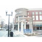
Notable locations in West Hartford: Rockledge Country Club (A), Buena Vista Recreational Complex (B), Hartford Country Club (C), Rockledge Country Club (D), Wampanoag Country Club (E), Pepper Brook Industrial Area (F), West Hartford Fire Department Station 4 (G), West Hartford Fire Department Station 3 (H), West Hartford Fire Department Station 2 (I), West Hartford Fire Chief's Office (J), West Hartford Fire Department Station 1 (K), Noah Webster Birthplace (L), West Hartford Library (M), Veterans Memorial Rink (N), Noah Webster Foundation (O), Historical Society Building of West Hartford (P), Faxon Branch Library (Q), Elmwood Community Center (R), Noah Webster Memorial Library (S), United Technologies Hall (T). Display/hide their locations on the map
Shopping Centers: Boulevard Shops Shopping Center (1), Shield Street Plaza Shopping Center (2), Sunset Plaza Shopping Center (3), Shops at Bishops Corner Shopping Center (4), Prospect Shopping Plaza Shopping Center (5), Bishops Corner West Shopping Center (6), Crossroads Plaza Shopping Center (7), Corbins Corner Shopping Parkade Shopping Center (8), Corbins Corner Shopping Center (9). Display/hide their locations on the map
Churches in West Hartford include: Saint John the Evangelist Church (A), Saint Mark the Evangelist Church (B), Shuvah Yisrael Messianic (C), Beth El Temple (D), Beth David Synagogue (E), Boulevard Baptist Church (F), Calvary Church (G), Chinese Baptist Church (H), Church of Saint Timothy (I). Display/hide their locations on the map
Lakes, reservoirs, and swamps: Welles Pond (A), Dyke Pond (B), Wood Pond (C), Woodridge Lake (D), Burnt Hill Reservoir (E), Talcott Reservoir (F), Mary Baker Stanley Pool (G), Bugbee Reservoir (H). Display/hide their locations on the map
Parks in West Hartford include: Batterson Park (1), Beach Park (2), Elizabeth Park Rose Garden (3), Hartford Golf Club Historic District (4), Kennedy Memorial Park (5), Nofeldt Little League (6), Prospect Avenue Historic District (7), Sterling Field (8), Beechland Park (9). Display/hide their locations on the map
Tourist attractions: Noah Webster House (Museums; 227 South Main Street), Gengras Planetarium (Museums; 950 Trout Brook Drive), West Hartford Historical Society (Cultural Attractions- Events- & Facilities; 227 South Main Street), University of Hartford - Libraries- Reference (Cultural Attractions- Events- & Facilities; 200 Bloomfield Avenue), Dadds Extreme Indoor Sports Complex LLC (Amusement & Theme Parks; 857 Boston Post Road), Disney Dream Vacations (Tours & Charters; 78 Vine Hill Road).
Hotel: West Hartford Inn (900 Farmington Avenue).
Courts: Connecticut State - Judicial Branch- Appellate Court- Probate Court Administration- Administr (186 Newington Road), West Hartford Town - Probate Court (50 South Main Street).
Birthplace of: John Franklin Enders - Businessman, John Lyons (American football) - Football player and coach, Kevin Galvin - Health activist, Michael Schur - Blogger, Peter Paige - Film actor, Theodore Sedgwick - Delegate, Joseph Mascolo - Film actor, Marc Lasry - Hedge fund manager, Chris Bruff - College basketball player (Maine Black Bears), J. Michael Farren - Lawyer.
Hartford County has a predicted average indoor radon screening level less than 2 pCi/L (pico curies per liter) - Low Potential
Drinking water stations with addresses in West Hartford and their reported violations in the past:
STATE LINE DINER (Address: Unit 111E , Serves RI,Population served: 70, Groundwater):
Past monitoring violations:
One routine major monitoring violation
Drinking water stations with addresses in West Hartford that have no violations reported:
RITAS ITALIAN ICE (Serves PA, Population served: 25,Primary Water Source Type: Groundwater)
Average household size:
This place:
2.4 people
Connecticut:
2.5 people
Percentage of family households:
This place:
63.9%
Whole state:
66.3%
Percentage of households with unmarried partners:
This place:
4.8%
Whole state:
6.6%
Likely homosexual households (counted as self-reported same-sex unmarried-partner households)
Lesbian couples: 0.7% of all households
Gay men: 0.4% of all households
People in group quarters in West Hartford in 2010:
969 people in nursing facilities/skilled-nursing facilities
796 people in college/university student housing
106 people in group homes intended for adults
91 people in other noninstitutional facilities
31 people in in-patient hospice facilities
30 people in residential schools for people with disabilities
23 people in mental (psychiatric) hospitals and psychiatric units in other hospitals
22 people in group homes for juveniles (non-correctional)
2 people in workers' group living quarters and job corps centers
People in group quarters in West Hartford in 2000:
3,250 people in college dormitories (includes college quarters off campus)
1,331 people in nursing homes
124 people in religious group quarters
35 people in other noninstitutional group quarters
24 people in other group homes
20 people in homes for the mentally ill
20 people in homes for the mentally retarded
12 people in homes or halfway houses for drug/alcohol abuse
8 people in homes for the physically handicapped
Banks with most branches in West Hartford (2011 data):
Bank of America, National Association: Bishops Corner Drive-Up Branch, Elmwood Branch, West Hartford Branch, Bishop's Corner Branch, Campus Center Branch, Corbin Corners Branch. Info updated 2009/11/18: Bank assets: $1,451,969.3 mil, Deposits: $1,077,176.8 mil, headquarters in Charlotte, NC, positive income, 5782 total offices, Holding Company: Bank Of America Corporation
People's United Bank: West Hartford-Farmington Ave Branch, Mcauley Branch, Bishop's Corner Branch, Elmwood Stop & Shop Branch, West Hartford Center Branch. Info updated 2012/02/16: Bank assets: $27,319.3 mil, Deposits: $20,835.4 mil, headquarters in Bridgeport, CT, positive income, Commercial Lending Specialization, 374 total offices
Sovereign Bank, National Association: Farmington Avenue Branch, Bishops Corner Branch, Boulevard Branch, Memorial Road Branch. Info updated 2012/01/31: Bank assets: $78,146.9 mil, Deposits: $48,042.9 mil, headquarters in Wilmington, DE, positive income, Commercial Lending Specialization, 718 total offices, Holding Company: Banco Santander, S.A.
Webster Bank, National Association: Elmwood Branch, West Hartford Center Branch, Park Road Branch, Bishops Corner Branch. Info updated 2008/12/23: Bank assets: $18,674.3 mil, Deposits: $13,861.5 mil, headquarters in Waterbury, CT, positive income, Commercial Lending Specialization, 167 total offices, Holding Company: Webster Financial Corporation
TD Bank, National Association: Town Center Branch at 29 South Main Street, branch established on 1996/07/10; West Hartford Branch at 143 S Main Street, branch established on 1980/06/21. Info updated 2010/10/04: Bank assets: $188,912.6 mil, Deposits: $153,149.8 mil, headquarters in Wilmington, DE, positive income, 1314 total offices, Holding Company: Toronto-Dominion Bank, The
Farmington Bank: Farmington Avenue Branch at 962 Farmington Avenue, branch established on 2004/11/29; West Hartford Branch at 176l Newington Road, branch established on 2011/04/05. Info updated 2009/10/20: Bank assets: $1,615.5 mil, Deposits: $1,256.2 mil, headquarters in Farmington, CT, positive income, Commercial Lending Specialization, 21 total offices, Holding Company: First Connecticut Bancorp, Inc.
First Niagara Bank, National Association: West Hartford Branch at 55 South Main Street, branch established on 1998/01/26. Info updated 2011/06/09: Bank assets: $32,750.6 mil, Deposits: $19,595.4 mil, headquarters in Buffalo, NY, positive income, Commercial Lending Specialization, 351 total offices, Holding Company: First Niagara Financial Group, Inc.
RBS Citizens, National Association: West Harford Branch at 15 South Main Street, branch established on 2007/04/30. Info updated 2007/09/19: Bank assets: $106,940.6 mil, Deposits: $75,690.2 mil, headquarters in Providence, RI, positive income, 1135 total offices, Holding Company: Uk Financial Investments Limited
The Connecticut Bank and Trust Company: West Hartford Branch at 68 South Main Street, branch established on 2004/03/29. Info updated 2006/11/03: Bank assets: $280.5 mil, Deposits: $220.0 mil, headquarters in Hartford, CT, negative income in the last year, Commercial Lending Specialization, 8 total offices
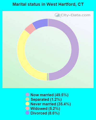
For population 15 years and over in West Hartford:
Never married: 35.4%
Now married: 49.5%
Separated: 1.2%
Widowed: 5.2%
Divorced: 8.6%
For population 25 years and over in West Hartford:
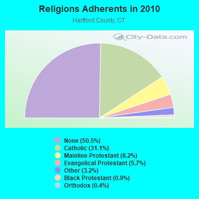
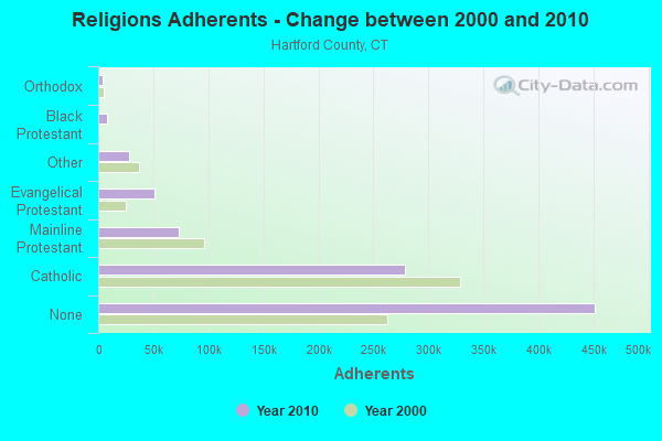
Religion statistics for West Hartford, CT (based on Hartford County data)
Religion
Adherents
Congregations
Catholic
278,203
100
Mainline Protestant
73,522
183
Evangelical Protestant
50,619
214
Other
28,183
94
Black Protestant
8,446
26
Orthodox
3,665
13
None
451,376
-
Source: Clifford Grammich, Kirk Hadaway, Richard Houseal, Dale E.Jones, Alexei Krindatch, Richie Stanley and Richard H.Taylor. 2012. 2010 U.S.Religion Census: Religious Congregations & Membership Study. Association of Statisticians of American Religious Bodies. Jones, Dale E., et al. 2002. Congregations and Membership in the United States 2000. Nashville, TN: Glenmary Research Center. Graphs represent county-level data
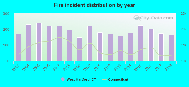
2003 - 2018 National Fire Incident Reporting System (NFIRS) incidents
According to the data from the years 2003 - 2018 the average number of fires per year is 193. The highest number of reported fires - 240 took place in 2005, and the least - 147 in 2009. The data has a declining trend.
When looking into fire subcategories, the most incidents belonged to: Structure Fires (48.1%), and Outside Fires (31.4%).
Fire incident types reported to NFIRS in West Hartford, CT
#5 on the list of "Top 101 cities with the lowest number of assaults per 100,000 residents (population 50,000+)"
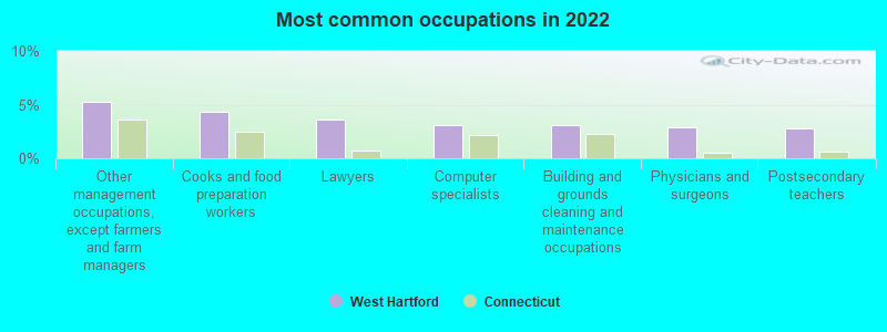
#7 on the list of "Top 101 cities with the most people having professional degrees (population 50,000+)"
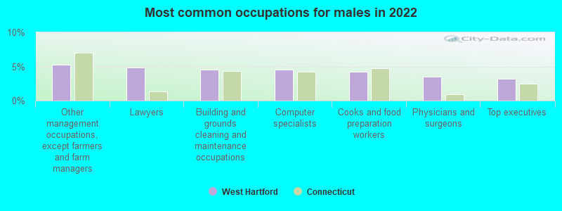
#9 on the list of "Top 101 cities with largest percentage of males in occupations: legal occupations (population 50,000+)"
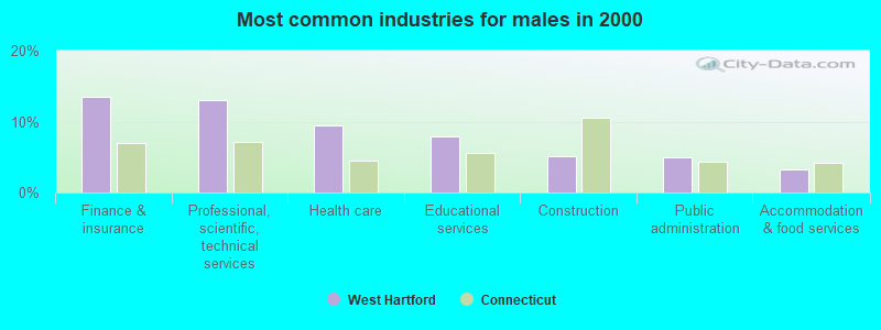
#12 on the list of "Top 101 cities with largest percentage of males in industries: finance and insurance (population 50,000+)"
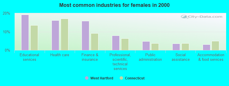
#15 on the list of "Top 101 cities with largest percentage of females in occupations: education, training, and library occupations (population 50,000+)"
#16 on the list of "Top 101 cities with largest percentage of males in industries: health care and social assistance (population 50,000+)"
#21 on the list of "Top 101 cities with the lowest number of rapes per 100,000 residents (population 50,000+)"
#22 on the list of "Top 101 cities with largest percentage of females in occupations: community and social service occupations (population 50,000+)"
#24 on the list of "Top 101 cities with largest percentage of males in occupations: health diagnosing and treating practitioners and other technical occupations (population 50,000+)"
#25 on the list of "Top 100 cities with the largest percentage of females (pop. 50,000+)"
#29 on the list of "Top 101 cities with the lowest number of murders per 100,000 residents (population 50,000+)"
#30 on the list of "Top 101 cities with largest percentage of females in occupations: legal occupations (population 50,000+)"
#30 on the list of "Top 101 cities with the most people having Master's or Doctorate degrees (population 50,000+)"
#35 on the list of "Top 101 cities with the smallest city-data.com crime index per police officer (population 50,000+)"
#35 on the list of "Top 101 cities with largest percentage of females in industries: finance and insurance (population 50,000+)"
#37 on the list of "Top 101 cities with the largest percentage of likely lesbian couples (counted as self-reported female-female unmarried-partner households) (population 50,000+)"
#37 on the list of "Top 101 cities with largest percentage of females in occupations: arts, design, entertainment, sports, and media occupations (population 50,000+)"
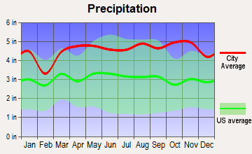
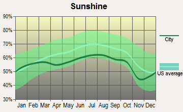
#37 on the list of "Top 101 cities with the lowest maximum monthly sunshine amount (population 50,000+)"
#38 on the list of "Top 101 cities with largest percentage of females in industries: information (population 50,000+)"
#45 on the list of "Top 101 cities with largest percentage of females in industries: educational services (population 50,000+)"
#60 (06107) on the list of "Top 101 zip codes with the largest percentage of taxpayers reporting taxable interest in 2012 (pop 5,000+)"
#93 (06107) on the list of "Top 101 zip codes with the largest percentage of taxpayers using charity contributions deductions in 2012 (pop 5,000+)"
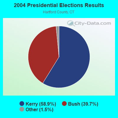
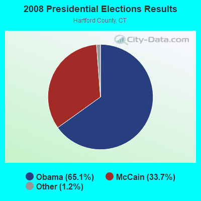
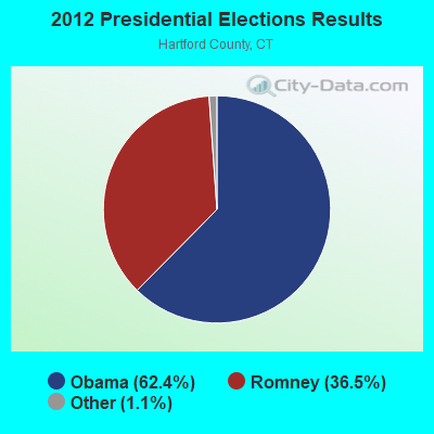
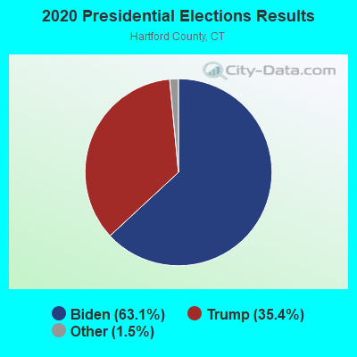
#2 on the list of "Top 101 counties with highest percentage of residents voting for Obama (Democrat) in the 2012 Presidential Election"
#17 on the list of "Top 101 counties with the most Catholic congregations"
#19 on the list of "Top 101 counties with the lowest Particulate Matter (PM10) Annual air pollution readings in 2012 (µg/m3)"
#24 on the list of "Top 101 counties with the highest percentage of residents that visited a dentist within the past year"
#29 on the list of "Top 101 counties with the most Mainline Protestant congregations"


 Recent articles from our blog. Our writers, many of them Ph.D. graduates or candidates, create easy-to-read articles on a wide variety of topics.

 (83.2 miles
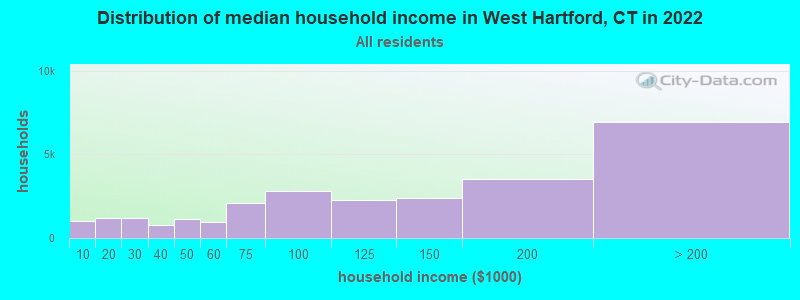


 According to the data from the years 2003 - 2018 the average number of fires per year is 193. The highest number of reported fires - 240 took place in 2005, and the least - 147 in 2009. The data has a declining trend.
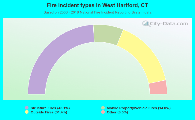 When looking into fire subcategories, the most incidents belonged to: Structure Fires (48.1%), and Outside Fires (31.4%).