Carter, Kentucky
Submit your own pictures of this place and show them to the world
- OSM Map
- General Map
- Google Map
- MSN Map

| Males: 887 | |
| Females: 885 |
| Median resident age: | 37.6 years |
| Kentucky median age: | 35.9 years |
Zip code: 41164
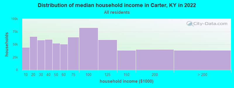
| Carter: | $42,420 |
| KY: | $59,341 |
Estimated per capita income in 2022: $21,119 (it was $11,223 in 2000)
Carter CCD income, earnings, and wages data
Estimated median house or condo value in 2022: $144,563 (it was $50,200 in 2000)
| Carter: | $144,563 |
| KY: | $196,300 |
Mean prices in 2022: all housing units: $146,454; detached houses: $165,822; townhouses or other attached units: $187,658; mobile homes: $82,189
Detailed information about poverty and poor residents in Carter, KY


- 1,73199.3%White alone
- 50.3%Two or more races
- 30.2%American Indian alone
- 40.2%Hispanic

Races in Carter detailed stats: ancestries, foreign born residents, place of birth
According to our research of Kentucky and other state lists, there were 2 registered sex offenders living in Carter, Kentucky as of May 29, 2024.
The ratio of all residents to sex offenders in Carter is 886 to 1.
The ratio of registered sex offenders to all residents in this city is lower than the state average.
 Recent articles from our blog. Our writers, many of them Ph.D. graduates or candidates, create easy-to-read articles on a wide variety of topics.
Current Local Time: EST time zone
Elevation: 680 feet
Land area: 83.0 square miles.
Population density: 21 people per square mile (very low).

| Carter CCD: | 0.5% ($269) |
| Kentucky: | 0.8% ($610) |
Nearest city with pop. 50,000+: Huntington, WV  (38.6 miles , pop. 51,475).
Nearest city with pop. 200,000+: Fayette, KY (78.0 miles , pop. 260,512).
Nearest city with pop. 1,000,000+: Chicago, IL (337.0 miles , pop. 2,896,016).
Nearest cities:
), ), ), ), ), Latitude: 38.42 N, Longitude: 83.15 W
Area code commonly used in this area: 606

| Here: | 7.2% |
| Kentucky: | 3.8% |
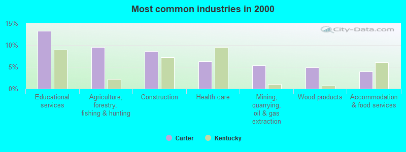
- Educational services (13.3%)
- Agriculture, forestry, fishing & hunting (9.6%)
- Construction (8.6%)
- Health care (6.3%)
- Mining, quarrying, oil & gas extraction (5.4%)
- Wood products (4.9%)
- Accommodation & food services (3.9%)
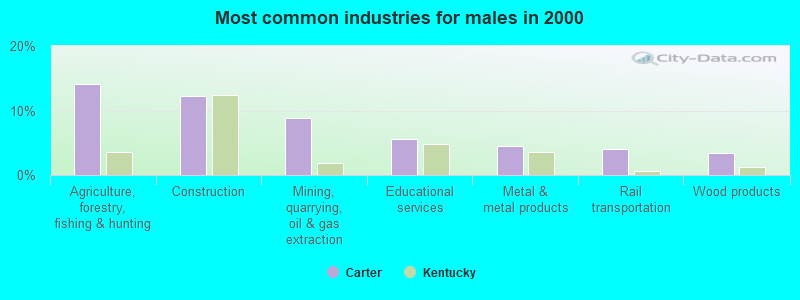
- Agriculture, forestry, fishing & hunting (14.2%)
- Construction (12.3%)
- Mining, quarrying, oil & gas extraction (8.8%)
- Educational services (5.6%)
- Metal & metal products (4.5%)
- Rail transportation (4.0%)
- Wood products (3.5%)
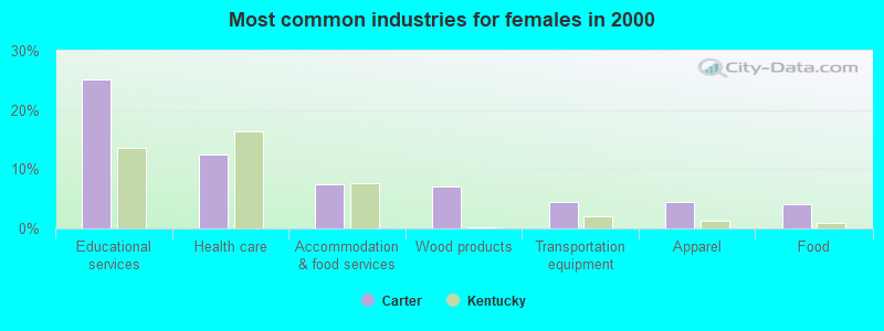
- Educational services (25.2%)
- Health care (12.4%)
- Accommodation & food services (7.4%)
- Wood products (7.0%)
- Transportation equipment (4.5%)
- Apparel (4.5%)
- Food (4.1%)

- Laborers and material movers, hand (7.5%)
- Other production occupations, including supervisors (7.1%)
- Electrical equipment mechanics and other installation, maintenance, and repair workers, including supervisors (6.3%)
- Preschool, kindergarten, elementary, and middle school teachers (5.8%)
- Cooks and food preparation workers (5.5%)
- Farmers and farm managers (4.7%)
- Other sales and related occupations, including supervisors (4.4%)

- Laborers and material movers, hand (11.0%)
- Electrical equipment mechanics and other installation, maintenance, and repair workers, including supervisors (8.6%)
- Fishing, hunting, and forestry occupations (6.7%)
- Farmers and farm managers (6.1%)
- Metal workers and plastic workers (5.6%)
- Other production occupations, including supervisors (5.3%)
- Electricians (4.3%)

- Preschool, kindergarten, elementary, and middle school teachers (12.4%)
- Cooks and food preparation workers (11.6%)
- Other production occupations, including supervisors (9.9%)
- Other sales and related occupations, including supervisors (5.4%)
- Other office and administrative support workers, including supervisors (5.4%)
- Textile, apparel, and furnishings workers (4.5%)
- Nursing, psychiatric, and home health aides (4.5%)
Average climate in Carter, Kentucky
Based on data reported by over 4,000 weather stations


(lower is better)

Air Quality Index (AQI) level in 2022 was 56.5. This is better than average.
| City: | 56.5 |
| U.S.: | 72.6 |

Sulfur Dioxide (SO2) [ppb] level in 2022 was 1.14. This is better than average. Closest monitor was 8.0 miles away from the city center.
| City: | 1.14 |
| U.S.: | 1.51 |

Ozone [ppb] level in 2022 was 25.4. This is better than average. Closest monitor was 14.9 miles away from the city center.
| City: | 25.4 |
| U.S.: | 33.3 |

Particulate Matter (PM2.5) [µg/m3] level in 2022 was 6.85. This is about average. Closest monitor was 14.9 miles away from the city center.
| City: | 6.85 |
| U.S.: | 8.11 |
Tornado activity:
Carter-area historical tornado activity is below Kentucky state average. It is 34% smaller than the overall U.S. average.
On 4/23/1968, a category F5 (max. wind speeds 261-318 mph) tornado 27.1 miles away from the Carter place center killed 7 people and injured 93 people and caused between $500,000 and $5,000,000 in damages.
On 5/10/2003, a category F3 (max. wind speeds 158-206 mph) tornado 11.1 miles away from the place center injured 17 people and caused $6 million in damages.
Earthquake activity:
Carter-area historical earthquake activity is significantly above Kentucky state average. It is 25% greater than the overall U.S. average.On 7/27/1980 at 18:52:21, a magnitude 5.2 (5.1 MB, 4.7 MS, 5.0 UK, 5.2 UK, Class: Moderate, Intensity: VI - VII) earthquake occurred 45.7 miles away from the city center
On 8/23/2011 at 17:51:04, a magnitude 5.8 (5.8 MW, Depth: 3.7 mi) earthquake occurred 285.4 miles away from Carter center
On 9/7/1988 at 02:28:09, a magnitude 4.6 (4.5 MB, 4.6 LG, Class: Light, Intensity: IV - V) earthquake occurred 44.0 miles away from the city center
On 8/9/2020 at 12:07:37, a magnitude 5.1 (5.1 MW, Depth: 4.7 mi) earthquake occurred 175.2 miles away from the city center
On 4/18/2008 at 09:36:59, a magnitude 5.4 (5.1 MB, 4.8 MS, 5.4 MW, 5.2 MW) earthquake occurred 256.8 miles away from the city center
On 4/18/2008 at 09:36:59, a magnitude 5.2 (5.2 MW, Depth: 8.9 mi) earthquake occurred 256.9 miles away from the city center
Magnitude types: regional Lg-wave magnitude (LG), body-wave magnitude (MB), surface-wave magnitude (MS), moment magnitude (MW)
Natural disasters:
The number of natural disasters in Carter County (26) is a lot greater than the US average (15).Major Disasters (Presidential) Declared: 20
Emergencies Declared: 3
Causes of natural disasters: Floods: 18, Storms: 17, Mudslides: 9, Tornadoes: 9, Winter Storms: 6, Landslides: 5, Winds: 2, Blizzard: 1, Hurricane: 1, Snowfall: 1, Snowstorm: 1, Other: 1 (Note: some incidents may be assigned to more than one category).
Colleges/universities with over 2000 students nearest to Carter:
- Morehead State University (about 23 miles; Morehead, KY; Full-time enrollment: 7,523)
- Shawnee State University (about 24 miles; Portsmouth, OH; FT enrollment: 4,160)
- Ashland Community and Technical College (about 28 miles; Ashland, KY; FT enrollment: 2,482)
- Maysville Community and Technical College (about 39 miles; Maysville, KY; FT enrollment: 2,969)
- Marshall University (about 39 miles; Huntington, WV; FT enrollment: 11,450)
- Big Sandy Community and Technical College (about 55 miles; Prestonsburg, KY; FT enrollment: 2,660)
- Southern State Community College (about 63 miles; Hillsboro, OH; FT enrollment: 2,418)
Public elementary/middle school in Carter:
- CUSTER ELEMENTARY SCHOOL (Students: 134, Location: 14880 HWY 690, Grades: PK-5)
Points of interest:
Notable location: Carter City Volunteer Fire Department (A). Display/hide its location on the map
Churches in Carter include: Kibbey Church (A), Mount Pleasant Church (B), Wesleyville Church (C), Boone Church (D), Oakland Church (E), Plummer Church (F), Bethel Church (G), Smith Creek Church (H). Display/hide their locations on the map
Cemeteries: Jordan Cemetery (1), Cooper Cemetery (2), Amey Cemetery (3), Everman Cemetery (4), Fults Cemetery (5), Kiser Cemetery (6), Zornes Cemetery (7). Display/hide their locations on the map
Streams, rivers, and creeks: Adams Creek (A), Barnes Branch (B), Big Run (C), Brushy Creek (D), Davis Fork (E), Colen Branch (F), Clark Branch (G), Thomas Branch (H), Cedar Run (I). Display/hide their locations on the map
Park in Carter: Carter Caves State Resort Park (1). Display/hide its location on the map
| This place: | 2.5 people |
| Kentucky: | 2.5 people |
| This place: | 71.4% |
| Whole state: | 66.9% |
| This place: | 7.1% |
| Whole state: | 6.4% |
Likely homosexual households (counted as self-reported same-sex unmarried-partner households)
- Lesbian couples: 0.0% of all households
- Gay men: 0.3% of all households
| This place: | 25.6% |
| Whole state: | 15.8% |
| This place: | 10.8% |
| Whole state: | 6.6% |
For population 15 years and over in Carter:

- Never married: 14.8%
- Now married: 71.9%
- Separated: 0.3%
- Widowed: 7.5%
- Divorced: 5.8%
For population 25 years and over in Carter:
- High school or higher: 57.5%
- Bachelor's degree or higher: 8.2%
- Graduate or professional degree: 3.6%
- Unemployed: 12.7%
- Mean travel time to work (commute): 36.5 minutes


| Here: | 17.4 |
| Kentucky average: | 13.8 |


Graphs represent county-level data. Detailed 2008 Election Results
Religion statistics for Carter, KY (based on Carter County data)


| Religion | Adherents | Congregations |
|---|---|---|
| Evangelical Protestant | 6,269 | 50 |
| Mainline Protestant | 666 | 8 |
| Black Protestant | 183 | 1 |
| Other | 157 | 1 |
| Catholic | 102 | 1 |
| None | 20,343 | - |
Food Environment Statistics:
| Carter County: | 3.28 / 10,000 pop. |
| Kentucky: | 2.19 / 10,000 pop. |
| Carter County: | 6.56 / 10,000 pop. |
| State: | 4.36 / 10,000 pop. |
| Carter County: | 3.65 / 10,000 pop. |
| Kentucky: | 5.74 / 10,000 pop. |
| Carter County: | 11.4% |
| Kentucky: | 11.0% |
| Carter County: | 33.8% |
| Kentucky: | 30.0% |
| This county: | 17.9% |
| Kentucky: | 15.9% |
Businesses in Carter, KY
- Lane Furniture: 1
Strongest AM radio stations in Carter:
- WGOH (1370 AM; 5 kW; GRAYSON, KY; Owner: CARTER COUNTY BROADCASTING CO., INC.)
- WTVN (610 AM; 50 kW; COLUMBUS, OH; Owner: CITICASTERS LICENSES, L.P.)
- WLGC (1520 AM; daytime; 5 kW; GREENUP, KY; Owner: GREENUP COUNTY BROADCASTING, INC.)
- WLW (700 AM; 50 kW; CINCINNATI, OH; Owner: JACOR BROADCASTING CORPORATION)
- WNXT (1260 AM; 5 kW; PORTSMOUTH, OH; Owner: HOMETOWN B/C OF PORTSMOUTH, INC.)
- WVHU (800 AM; 5 kW; HUNTINGTON, WV; Owner: CAPSTAR TX LIMITED PARTNERSHIP)
- WRVC (930 AM; 5 kW; HUNTINGTON, WV; Owner: FIFTH AVENUE BROADCASTING COMPANY, INC.)
- WTCR (1420 AM; 5 kW; KENOVA, WV; Owner: CAPSTAR TX LIMITED PARTNERSHIP)
- WSAI (1530 AM; 50 kW; CINCINNATI, OH; Owner: JACOR BROADCASTING CORPORATION)
- WOKT (1040 AM; daytime; 2 kW; CANNONSBURG, KY; Owner: BIG RIVER RADIO, INC.-KY)
- WHAS (840 AM; 50 kW; LOUISVILLE, KY; Owner: CLEAR CHANNEL BROADCASTING LICENSES, INC.)
- WKYH (600 AM; 5 kW; PAINTSVILLE, KY; Owner: HIGHLANDS BROADCASTING CORPORATION)
- WHRD (1470 AM; 5 kW; HUNTINGTON, WV; Owner: CONCORD MEDIA GROUP, INC.)
Strongest FM radio stations in Carter:
- WPAY-FM (104.1 FM; PORTSMOUTH, OH; Owner: RADIO STATIONS WPAY/WPFB, INC.)
- WOSP (91.5 FM; PORTSMOUTH, OH; Owner: THE OHIO STATE UNIVERSITY)
- WMKY (90.3 FM; MOREHEAD, KY; Owner: MOREHEAD STATE UNIVERSITY)
- WUGO (102.3 FM; GRAYSON, KY; Owner: CARTER COUNTY BROADCASTING CO., INC.)
- WOKE (98.3 FM; GARRISON, KY; Owner: BIG RIVER RADIO, INC.)
- WOHP (88.3 FM; PORTSMOUTH, OH; Owner: THE CEDARVILLE UNIVERSITY)
- WDGG (93.7 FM; ASHLAND, KY; Owner: FIFTH AVENUE B/CASTING COMPANY, INC.)
- WLGC-FM (105.7 FM; GREENUP, KY; Owner: GREENUP COUNTY BROADCASTING, INC.)
- WBKS (107.1 FM; IRONTON, OH; Owner: CAPSTAR TX LIMITED PARTNERSHIP)
- WBMK (88.5 FM; MOREHEAD, KY; Owner: AMERICAN FAMILY ASSOCIATION)
- WNXT-FM (99.3 FM; PORTSMOUTH, OH; Owner: HOMETOWN B/C OF PORTSMOUTH, INC.)
- W215AV (90.9 FM; SOUTH PORTSMOUTH, KY; Owner: CALVARY CHAPEL OF TWIN FALLS, INC.)
- WFLE-FM (95.1 FM; FLEMINGSBURG, KY; Owner: FLEMING COUNTY BROADCASTING CO., INC)
- WZZZ (107.5 FM; PORTSMOUTH, OH; Owner: HOMETOWN BROADCASTING OF PORTSMOUTH 2, INC.)
- WKKS-FM (104.9 FM; VANCEBURG, KY; Owner: BROWN COMMUNICATIONS, INC.)
- WBVB (97.1 FM; COAL GROVE, OH; Owner: CAPSTAR TX LIMITED PARTNERSHIP)
- WRVC-FM (92.7 FM; CATLETTSBURG, KY; Owner: FIFTH AVENUE BROADCASTING CO., INC)
- WQXX (106.1 FM; MOREHEAD, KY; Owner: MORGAN COUNTY INDUSTRIES, INC.)
- WIVY (96.3 FM; MOREHEAD, KY; Owner: GATEWAY RADIO WORKS, INC.)
- WOUL-FM (89.1 FM; IRONTON, OH; Owner: OHIO UNIVERSITY)
TV broadcast stations around Carter:
- WPBO (Channel 42; PORTSMOUTH, OH; Owner: THE OHIO STATE UNIVERSITY)
- WHCP (Channel 30; PORTSMOUTH, OH; Owner: TELEVISION PROPERTIES, INC.)
- WKMR (Channel 38; MOREHEAD, KY; Owner: KENTUCKY AUTHORITY FOR EDUCATIONAL TV)
- WUPX-TV (Channel 67; MOREHEAD, KY; Owner: PAXSON LEXINGTON LICENSE, INC.)
- WPBY-TV (Channel 33; HUNTINGTON, WV; Owner: WEST VIRGINIA EDUCATIONAL BROADCASTING AUTHORITY)
- W66CZ (Channel 66; PORTSMOUTH, OH; Owner: TRINITY BROADCASTING NETWORK)
Carter fatal accident list:
FCC Registered Antenna Towers:
5- ERIK C SWANSON, 1 Mile Southwest Of (Lat: 38.418889 Lon: -83.131361), Type: 424.6, Overall height: 424.6 m, Registrant: Hatfield & Dawson Consulting Engineers, Eswanson@hatdaw.Com, , Seatt-le, Phone: (206) 783-9151
- Teresa Schuller, 13900 State Highway 2 (Wv220a), Type: 92.7, Structure height: 21043 m, Overall height: 91.4 m, Registrant: At&t Mobility Services, LLC, Anisa.A.Latif@att.Com, , Washi-ngton, Phone: (202) 457-3068
- Teresa Schuller, 13900 State Highway 2 (Wv220a), Type: 92.7, Structure height: 21043 m, Overall height: 91.4 m, Registrant: At&t Mobility Services, LLC, Anisa.A.Latif@att.Com, , Washi-ngton, Phone: (202) 457-3068
- LAURIE LINNMAN, 1 Mile Southwest Of (Lat: 38.418889 Lon: -83.131361), Type: 424.6, Structure height: 21043 m, Overall height: 424.6 m, Registrant: Fletcher, Heald & Hildreth, Plc, Mccormick@fhhlaw.Com, 11th Floor, Arlin-gton, Phone: (703) 812-0438
- LAURIE LINMAN, 1 Mile Southwest Of (Lat: 38.418889 Lon: -83.131361), Type: 424.6, Structure height: 21043 m, Overall height: 424.6 m, Registrant: Fletcher, Heald & Hildreth, Plc, Mccormick@fhhlaw.Com, 11th Floor, Arlin-gton, Phone: (703) 812-0438
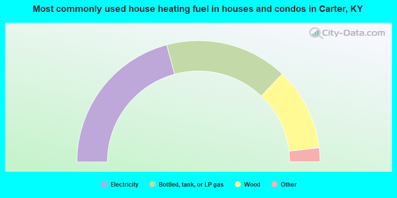
- 41.6%Electricity
- 32.6%Bottled, tank, or LP gas
- 22.1%Wood
- 1.9%Fuel oil, kerosene, etc.
- 1.0%Utility gas
- 0.8%Coal or coke
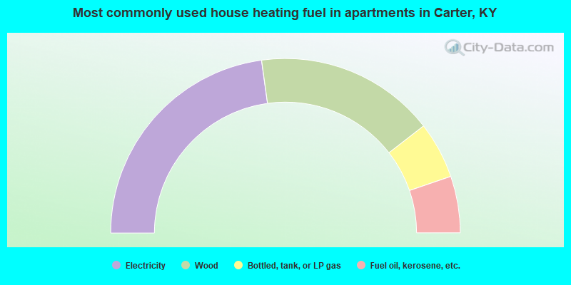
- 45.6%Electricity
- 33.3%Wood
- 10.5%Bottled, tank, or LP gas
- 10.5%Fuel oil, kerosene, etc.
Carter compared to Kentucky state average:
- Black race population percentage significantly below state average.
- Hispanic race population percentage significantly below state average.
- Foreign-born population percentage significantly below state average.
- Renting percentage significantly below state average.
- Length of stay since moving in significantly above state average.
- Number of rooms per house significantly below state average.
- House age significantly below state average.
- Number of college students below state average.
- Percentage of population with a bachelor's degree or higher significantly below state average.
State forum archive: