Property valuation of F M Rd 1826, Austin, TX (tax assessments)
Other nearby streets: Bettis Trophy Drive (1)  Bettis Trophy Drive (2)
Bettis Trophy Drive (3)
Cowher Court
Rooney Cove
Bettis Trophy Drive (2)
Bettis Trophy Drive (3)
Cowher Court
Rooney Cove
Bettis Trophy Drive (2)
Bettis Trophy Drive (3)
Cowher Court
Rooney Cove
Listed properties vs overall distribution of properties in Austin, TX:
Advertisements
F M Rd 1826
Austin, TX 78737
Find on map >>
Owner: RAILROAD BARBECUE INC
Property type: Real
Appraisal or Tax Year: 2013
Total market building value: $34,843 (it was $55,295 in 2009)
Total market value for property: $34,843 (it was $55,295 in 2009)
Property improvements: 1st floor, Porch open 1st floor
Austin, TX 78737
Find on map >>
Owner: RAILROAD BARBECUE INC
Property type: Real
Appraisal or Tax Year: 2013
Total market building value: $34,843 (it was $55,295 in 2009)
Total market value for property: $34,843 (it was $55,295 in 2009)
Property improvements: 1st floor, Porch open 1st floor
F M Rd 1826
Austin, TX 78645
Find on map >>
Owner: LIBERTY BANKERS LIFE INSURANCE COMPANY
Property type: Real
Property tax division code: D1 - Acreage (Ag) 1-D-1
Appraisal or Tax Year: 2013
Total market land value: $451,964
Total market value for property: $105,693 (it was $451,964 in 2009)
Land size: 3,939,087 square feet
F M Rd 1826
Austin, TX 78737
Find on map >>
Owner: LEON GRIFFIN
Property type: Real
Property tax division code: D2 - Acreage (Non-Ag)
Appraisal or Tax Year: 2013
Total market land value: $2,550
Total market value for property: $2,550 (it was $2,550 in 2009)
Land size: 43,560 square feet
Austin, TX 78737
Find on map >>
Owner: LEON GRIFFIN
Property type: Real
Property tax division code: D2 - Acreage (Non-Ag)
Appraisal or Tax Year: 2013
Total market land value: $2,550
Total market value for property: $2,550 (it was $2,550 in 2009)
Land size: 43,560 square feet
F M Rd 1826
Austin, TX
Find on map >>
Owner: WEST TRAVIS COUNTY PUBLIC UTILITY AGENCY & LLOYD GOSSELINK ROCHELLE & TOWNSEND, PC
Property type: Real
Property tax division code: D2 - Acreage (Non-Ag)
Appraisal or Tax Year: 2013
Total market land value: $6,315
Total market building value: $6,315 (it was $12,630 in 2009)
Total market value for property: $12,630 (it was $12,630 in 2009)
Land size: 7,187 square feet
F M Rd 1826
Austin, TX
Find on map >>
Owner: CURTIS W CLINE & MILLER CLINE KIM
Property type: Real
Property tax division code: C1 - Vacant Lot
Appraisal or Tax Year: 2009
Total market land value: $4,690
Total market value for property: $4,690
Land size: 5,837 square feet
Austin, TX
Find on map >>
Owner: CURTIS W CLINE & MILLER CLINE KIM
Property type: Real
Property tax division code: C1 - Vacant Lot
Appraisal or Tax Year: 2009
Total market land value: $4,690
Total market value for property: $4,690
Land size: 5,837 square feet
F M Rd 1826
Austin, TX 78737
Find on map >>
Owner: CITY OF AUSTIN
Property type: Real
Property tax division code: E1 - Farm And Ranch Impr
Appraisal or Tax Year: 2013
Total market land value: $5,372,136
Total market value for property: $5,372,136 (it was $5,372,136 in 2009)
Land size: 5,909,350 square feet
Austin, TX 78737
Find on map >>
Owner: CITY OF AUSTIN
Property type: Real
Property tax division code: E1 - Farm And Ranch Impr
Appraisal or Tax Year: 2013
Total market land value: $5,372,136
Total market value for property: $5,372,136 (it was $5,372,136 in 2009)
Land size: 5,909,350 square feet
F M Rd 1826
Austin, TX
Find on map >>
Owner: CITY OF AUSTIN
Property type: Real
Property tax division code: A1 - Single Family Residence
Appraisal or Tax Year: 2013
Total market land value: $2,861,145
Total market building value: $34,249 (it was $2,895,394 in 2009)
Total market value for property: $2,895,394 (it was $2,895,394 in 2009)
Land size: 2,769,588 square feet
Property improvements: 1st floor, Bathroom, Carport attached 1st, Fireplace, Heating ventilation and air conditioning residential, Obs driveway, Porch open 1st floor, Terrace covered
Roof Style: Gable
Roof Covering: Composition
Foundation: Slab
F M Rd 1826
Austin, TX 78737
Find on map >>
Owner: ROBERT J RATCLIFFE & CRUMP N GEORGIA
Property type: Real
Property tax division code: C1 - Vacant Lot
Appraisal or Tax Year: 2013
Total market land value: $14,310
Total market value for property: $14,310 (it was $14,310 in 2009)
Land size: 23,087 square feet
Austin, TX 78737
Find on map >>
Owner: ROBERT J RATCLIFFE & CRUMP N GEORGIA
Property type: Real
Property tax division code: C1 - Vacant Lot
Appraisal or Tax Year: 2013
Total market land value: $14,310
Total market value for property: $14,310 (it was $14,310 in 2009)
Land size: 23,087 square feet
F M Rd 1826
Austin, TX 78737
Find on map >>
Owner: CIRCLE C HOMEOWNERS ASSOCIATION INC
Property type: Real
Property tax division code: D2 - Acreage (Non-Ag)
Appraisal or Tax Year: 2009
Total market land value: $73,352
Total market value for property: $73,352
Land size: 293,677 square feet
Austin, TX 78737
Find on map >>
Owner: CIRCLE C HOMEOWNERS ASSOCIATION INC
Property type: Real
Property tax division code: D2 - Acreage (Non-Ag)
Appraisal or Tax Year: 2009
Total market land value: $73,352
Total market value for property: $73,352
Land size: 293,677 square feet
F M Rd 1826
Austin, TX
Find on map >>
Owner: MANTRA HOLDING LLC
Property type: Real
Property tax division code: D2 - Acreage (Non-Ag)
Appraisal or Tax Year: 2013
Total market land value: $214,200
Total market value for property: $214,200 (it was $214,200 in 2009)
Land size: 466,528 square feet
Austin, TX
Find on map >>
Owner: MANTRA HOLDING LLC
Property type: Real
Property tax division code: D2 - Acreage (Non-Ag)
Appraisal or Tax Year: 2013
Total market land value: $214,200
Total market value for property: $214,200 (it was $214,200 in 2009)
Land size: 466,528 square feet
Other nearby streets: Bettis Trophy Drive (1)
Bettis Trophy Drive (2)
Bettis Trophy Drive (3)
Cowher Court
Rooney Cove
Bettis Trophy Drive (2)
Bettis Trophy Drive (3)
Cowher Court
Rooney Cove

Recent posts about Austin, Texas on our local forum with over 2,400,000 registered users. Austin is mentioned 145,836 times on our forum:
 | Why tech talent is in the process of abandoning Austin (34 replies) |
| Austin Trip Reflection (30 replies) |
| Let’s be honest. What’s your take on Austin and newcomers? (42 replies) |
| How much longer does Austin have? (338 replies) |
| UT Austin Policy Report Shows Austin's the Only Fast-Growing City Losing African-Americans (150 replies) |
| Latest crime statistics for Austin, 2016 (2 replies) |
Settings
X

Recently Added Photos

Austin, TX

Austin, TX

Austin, TX

Austin, TX
Austin, TX

Austin, TX

Austin, TX

Austin, TX

Austin, TX

Austin, TX

Austin, TX

Austin, TX
Request disassociating your name from street-level assessment address

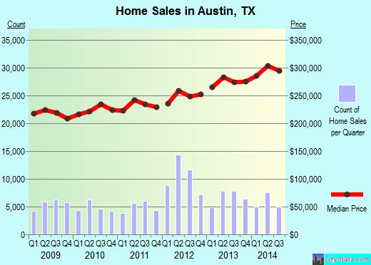
Recent home sales, price trends, and home value evaluator powered by Onboard Informatics
© 2024 Onboard Informatics. Information is deemed reliable but not guaranteed.
© 2024 Onboard Informatics. Information is deemed reliable but not guaranteed.
Some parts © 2024 Advameg, Inc.
Compilation, repackaging, or reproduction prohibited. Users are forewarned that it is incumbent upon them to verify information with the responsible state agency. Advameg, Inc. does not guarantee the data presented is up-to-date nor does it assume responsibility for updating it. Therefore any names, owners or addresses may have changed. Use of any information published here to contact the persons might be prohibited by the law.