Bridge Statistics for Abilene, Kansas (KS)
Condition, Traffic, Stress, Structural Evaluation, Project Costs
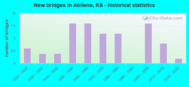
- New bridges - historical statistics
- 31920-1929
- 21930-1939
- 21940-1949
- 81950-1959
- 81960-1969
- 61970-1979
- 61980-1989
- 82000-2009
- 42010-2019
- 12020-2022
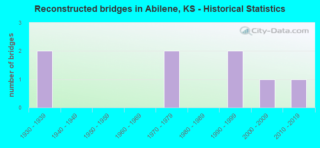
- Reconstructed bridges - Historical Statistics
- 21930-1939
- 01940-1949
- 01950-1959
- 01960-1969
- 21970-1979
- 01980-1989
- 21990-1999
- 12000-2009
- 12010-2019
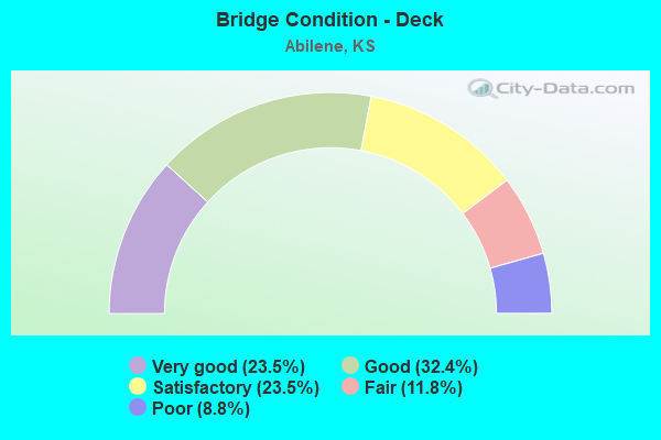
- Bridge Condition - Deck
- 23.5%Very good
- 32.4%Good
- 23.5%Satisfactory
- 11.8%Fair
- 8.8%Poor
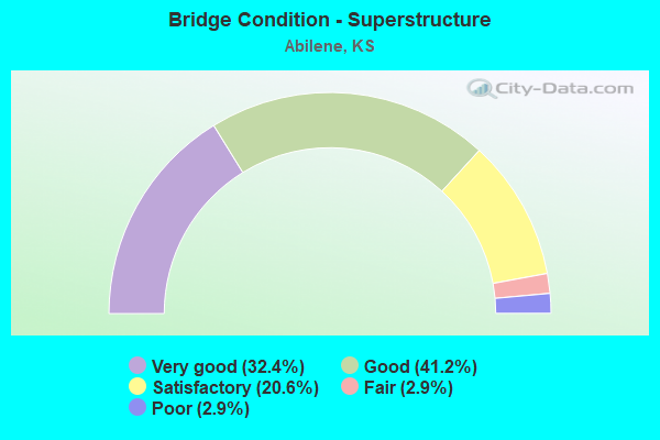
- Bridge Condition - Superstructure
- 32.4%Very good
- 41.2%Good
- 20.6%Satisfactory
- 2.9%Fair
- 2.9%Poor
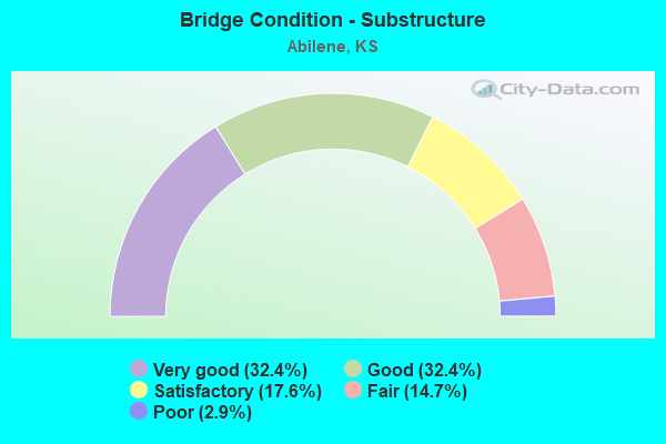
- Bridge Condition - Substructure
- 32.4%Very good
- 32.4%Good
- 17.6%Satisfactory
- 14.7%Fair
- 2.9%Poor
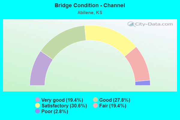
- Bridge Condition - Channel
- 19.4%Very good
- 27.8%Good
- 30.6%Satisfactory
- 19.4%Fair
- 2.8%Poor
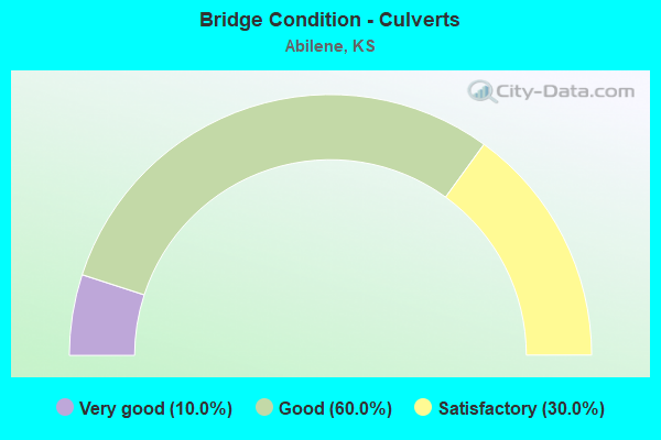
- Bridge Condition - Culverts
- 10.0%Very good
- 60.0%Good
- 30.0%Satisfactory
Find on map >> Show street view
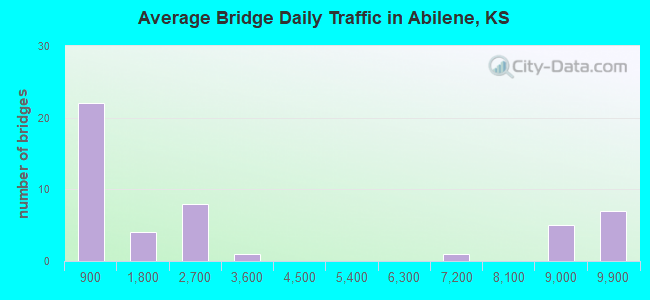
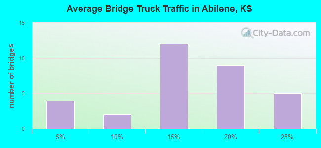
Structure Number: 999907000211021, Location: 8.1 MI E of SALINE COLN (Lat: 38.937500, Lng: -97.232500), Route carried "on" structure: Interstate 70, Year Built: 2005, Status: Open, Structure Length: 5.07m (16.63ft), Average Daily Traffic: 9,715 (year 2020), Truck Traffic: 19%, Average Future Daily Traffic: 13,880 (year 2041), Design Load: HL 93, Features Intersected: BNSF RAILWAY
Minimum Vertical Clearance: 30.47m (99.97ft), Kilometerpoint: 13.063, Lanes on structure: 2, Base Highway Network: Yes, Owner: State Highway Agency, Approaching Roadway Width: 12.2m (40.0ft), Material/Design: Steel continuous, Design/Construction: Stringer/Multi-beam, Number Of Spans In Main Unit: 3, Length of Maximum Span: 20.0m (65.6ft), Curb-To-Curb Width: 12.2m (40.0ft), Out-to-Out Width: 13.0m (42.7ft)
Condition: Deck: Very good, Superstructure: Very good, Substructure: Very good, Operating Rating: 44.7 metric tons, Method Used To Determine Operating Rating: Load and Resistance Factor Rating (LRFR) rating reported by rating factor(RF) method using HL-93 loadings, Inventory Rating: 33.0 metric tons, Method Used To Determine Inventory Rating: Load and Resistance Factor Rating (LRFR) rating reported by rating factor(RF) method using HL-93 loadings, Structural Evaluation: Equal to present desirable criteria, Deck Geometry: Better than present minimum criteria, Underclear: Better than present minimum criteria, Approach Roadway Alignment: Equal to present desirable criteria, Length Of Structure Improvement: 16.65m (54.63ft), Designated Inspection Frequency: Every 24 months, Inspection Date: October 2021, Wearing Surface/Protective System: Wearing Surface: Low Slump Concrete, Deck Protection: Epoxy Coated Reinforcing
Find on map >> Show street view
Structure Number: 999907000211031, Location: 7.72 MI E K221/I70 JCT (Lat: 38.937778, Lng: -97.230556), Route carried "on" structure: Interstate 70, Year Built: 2006, Status: Open, Structure Length: 7.32m (24.02ft), Average Daily Traffic: 9,715 (year 2020), Truck Traffic: 19%, Average Future Daily Traffic: 13,880 (year 2041), Design Load: HS 20, Features Intersected: MUD CREEK
Minimum Vertical Clearance: 30.47m (99.97ft), Kilometerpoint: 13.216, Lanes on structure: 2, Base Highway Network: Yes, Owner: State Highway Agency, Approaching Roadway Width: 12.2m (40.0ft), Material/Design: Prestressed concrete continuous, Design/Construction: Stringer/Multi-beam, Number Of Spans In Main Unit: 3, Length of Maximum Span: 25.5m (83.7ft), Curb-To-Curb Width: 12.2m (40.0ft), Out-to-Out Width: 12.8m (42.0ft)
Condition: Deck: Good, Superstructure: Very good, Substructure: Very good, Channel: Very good, Operating Rating: 52.8 metric tons, Method Used To Determine Operating Rating: Load and Resistance Factor Rating (LRFR) rating reported by rating factor(RF) method using HL-93 loadings, Inventory Rating: 23.3 metric tons, Method Used To Determine Inventory Rating: Load and Resistance Factor Rating (LRFR) rating reported by rating factor(RF) method using HL-93 loadings, Structural Evaluation: Somewhat better than minimum adequacy, Deck Geometry: Better than present minimum criteria, Waterway Adequacy: Equal to present desirable criteria, Approach Roadway Alignment: Equal to present desirable criteria, Length Of Structure Improvement: 24.03m (78.84ft), Designated Inspection Frequency: Every 24 months, Inspection Date: October 2021, Wearing Surface/Protective System: Wearing Surface: Low Slump Concrete, Deck Protection: Epoxy Coated Reinforcing
Find on map >> Show street view
Structure Number: 999907000211041, Location: 7.72 MI E K221/I70 JCT (Lat: 38.937500, Lng: -97.230556), Route carried "on" structure: Interstate 70, Year Built: 2005, Status: Open, Structure Length: 7.32m (24.02ft), Average Daily Traffic: 9,715 (year 2020), Truck Traffic: 19%, Average Future Daily Traffic: 13,880 (year 2041), Design Load: HS 20, Features Intersected: MUD CREEK
Minimum Vertical Clearance: 30.47m (99.97ft), Kilometerpoint: 13.216, Lanes on structure: 2, Base Highway Network: Yes, Owner: State Highway Agency, Approaching Roadway Width: 12.2m (40.0ft), Material/Design: Prestressed concrete continuous, Design/Construction: Stringer/Multi-beam, Number Of Spans In Main Unit: 3, Length of Maximum Span: 25.5m (83.7ft), Curb-To-Curb Width: 12.2m (40.0ft), Out-to-Out Width: 12.8m (42.0ft)
Condition: Deck: Good, Superstructure: Very good, Substructure: Very good, Channel: Very good, Operating Rating: 39.9 metric tons, Method Used To Determine Operating Rating: Load and Resistance Factor Rating (LRFR) rating reported by rating factor(RF) method using HL-93 loadings, Inventory Rating: 23.3 metric tons, Method Used To Determine Inventory Rating: Load and Resistance Factor Rating (LRFR) rating reported by rating factor(RF) method using HL-93 loadings, Structural Evaluation: Somewhat better than minimum adequacy, Deck Geometry: Better than present minimum criteria, Waterway Adequacy: Equal to present desirable criteria, Approach Roadway Alignment: Equal to present desirable criteria, Length Of Structure Improvement: 24.03m (78.84ft), Designated Inspection Frequency: Every 24 months, Inspection Date: October 2021, Wearing Surface/Protective System: Wearing Surface: Low Slump Concrete, Deck Protection: Epoxy Coated Reinforcing
Find on map >> Show street view
Structure Number: 999907000210061, Location: 7.6 MI E OF SALINE COLN (Lat: 38.937222, Lng: -97.241667), Route carried "under" structure: Interstate 70, Year Built: 1961, Structure Length: 0. m, Average Daily Traffic: 9,715 (year 2020), Truck Traffic: 19%, Features Intersected: I70 HWY, EB/WB, Facility Carried by Structure: LOCAL ROAD
Minimum Vertical Clearance: 5.09m (16.70ft), Kilometerpoint: 12.260, Lanes on structure: 2, Lanes under structure: 4, Material/Design: Concrete continuous, Design/Construction: Box Beam or Girders - Multiple, Length of Maximum Span: 20.7m (67.9ft)
Find on map >> Show street view
Structure Number: 999907000210111, Location: JCT K15/I70 WB (Lat: 38.940278, Lng: -97.213889), Route carried "under" structure: State highway 15, Year Built: 1959, Structure Length: 0. m, Average Daily Traffic: 9,060 (year 2020), Truck Traffic: 5%, Features Intersected: K15 HIGHWAY, Facility Carried by Structure: I70 HWY, WB
Minimum Vertical Clearance: 4.52m (14.83ft), Kilometerpoint: 37.118, Lanes on structure: 2, Lanes under structure: 4, Material/Design: Concrete continuous, Design/Construction: Slab, Length of Maximum Span: 13.7m (44.9ft)
Find on map >> Show street view
Structure Number: 999907000210121, Location: JCT K15/I70 SL (Lat: 38.940000, Lng: -97.213889), Route carried "under" structure: State highway 15, Year Built: 1959, Structure Length: 0. m, Average Daily Traffic: 9,060 (year 2020), Truck Traffic: 5%, Features Intersected: K15 HIGHWAY, Facility Carried by Structure: I70 HWY, EB
Minimum Vertical Clearance: 4.59m (15.06ft), Kilometerpoint: 37.089, Lanes on structure: 2, Lanes under structure: 4, Material/Design: Concrete continuous, Design/Construction: Slab, Length of Maximum Span: 13.7m (44.9ft)
Find on map >> Show street view
Structure Number: 999907000211001, Location: 6.60 MI E OF SALINE COLN (Lat: 38.935000, Lng: -97.260556), Route carried "under" structure: Interstate 70, Year Built: 2005, Structure Length: 0. m, Average Daily Traffic: 8,702 (year 2020), Truck Traffic: 21%, Features Intersected: I-70 HWY, WB-EB, Facility Carried by Structure: RS0189
Minimum Vertical Clearance: 5.38m (17.65ft), Kilometerpoint: 10.598, Lanes on structure: 2, Lanes under structure: 4, Material/Design: Steel continuous, Design/Construction: Stringer/Multi-beam, Length of Maximum Span: 32.0m (105.0ft)