Bridge Statistics for Carrollton, Texas (TX)
Condition, Traffic, Stress, Structural Evaluation, Project Costs
- National Bridge Inventory (NBI) Statistics
- 221Number of bridges
- 9,108ft / 2,776mTotal length
- $757,000Total costs
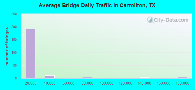
- 3,696,418Total average daily traffic
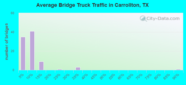
- 196,233Total average daily truck traffic
- National Bridge Inventory (NBI) Registered Bridges for Carrollton
- No street view available for this location
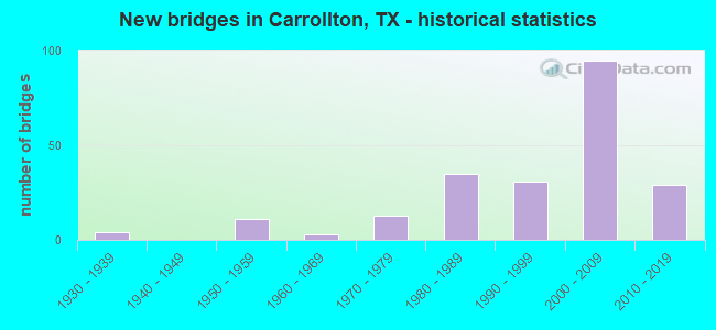
- New bridges - historical statistics
- 41930-1939
- 111950-1959
- 31960-1969
- 131970-1979
- 351980-1989
- 311990-1999
- 952000-2009
- 292010-2019
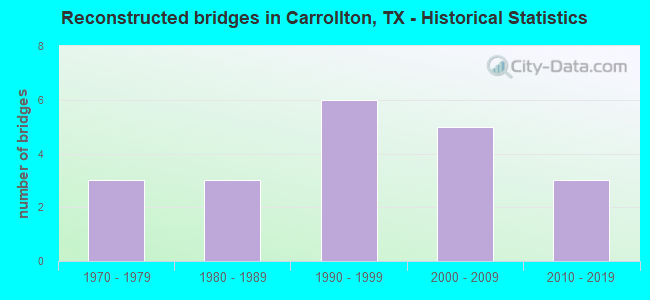
- Reconstructed bridges - Historical Statistics
- 31970-1979
- 31980-1989
- 61990-1999
- 52000-2009
- 32010-2019
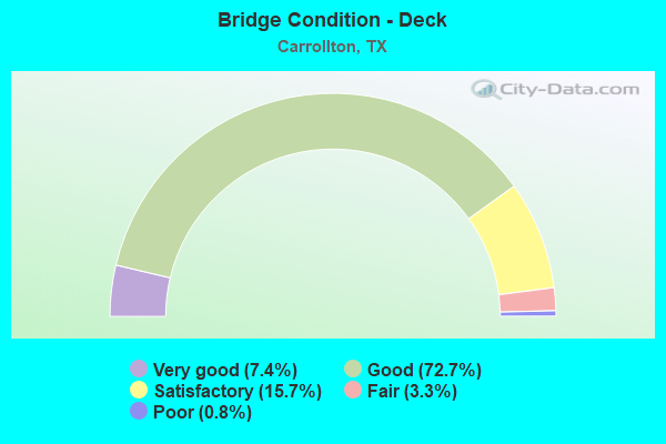
- Bridge Condition - Deck
- 7.4%Very good
- 72.7%Good
- 15.7%Satisfactory
- 3.3%Fair
- 0.8%Poor
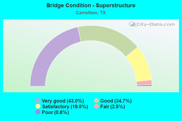
- Bridge Condition - Superstructure
- 43.0%Very good
- 34.7%Good
- 19.0%Satisfactory
- 2.5%Fair
- 0.8%Poor
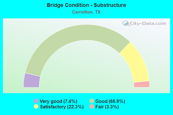
- Bridge Condition - Substructure
- 7.4%Very good
- 66.9%Good
- 22.3%Satisfactory
- 3.3%Fair
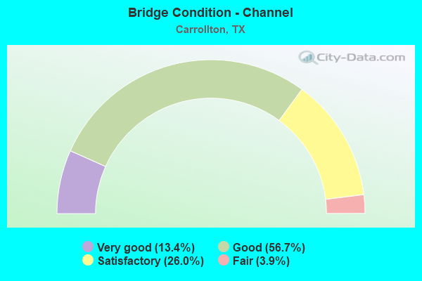
- Bridge Condition - Channel
- 13.4%Very good
- 56.7%Good
- 26.0%Satisfactory
- 3.9%Fair
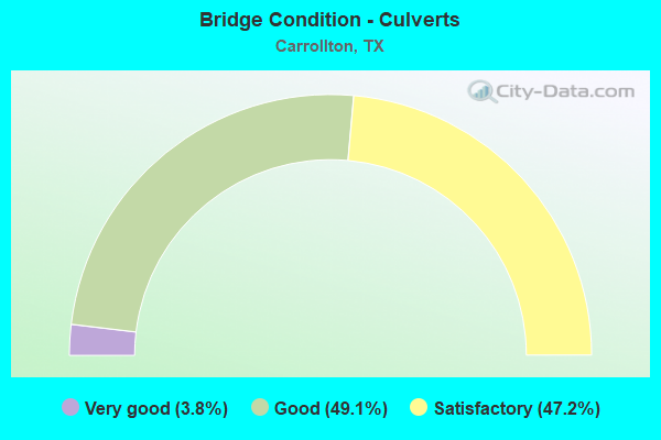
- Bridge Condition - Culverts
- 3.8%Very good
- 49.1%Good
- 47.2%Satisfactory
Find on map >> Show street view
Structure Number: 180570019603003, Location: 5.5 Mi N of IH 635 (Lat: 32.981086, Lng: -96.929086), Route carried "on" structure: Interstate 35, Year Built: 2003, Status: Open, Structure Length: 7.50m (24.61ft), Average Daily Traffic: 86,726 (year 2019), Truck Traffic: 8%, Average Future Daily Traffic: 100,000 (year 2035), Design Load: HS 20, Features Intersected: Furneaux Creek
Minimum Vertical Clearance: 30+ m (98+ ft), Kilometerpoint: 0.002, Lanes on structure: 4, Owner: State Highway Agency, Approaching Roadway Width: 18.3m (60.0ft), Material/Design: Prestressed concrete, Design/Construction: Stringer/Multi-beam, Number Of Spans In Main Unit: 3, Length of Maximum Span: 25.0m (82.0ft), Curb-To-Curb Width: 20.5m (67.3ft), Out-to-Out Width: 30.8m (101.0ft)
Condition: Deck: Good, Superstructure: Very good, Substructure: Good, Channel: Good, Operating Rating: 44.4 metric tons, Method Used To Determine Operating Rating: Assigned rating based on Load Factor Design (LFD) reported in metric tons, Inventory Rating: 32.7 metric tons, Method Used To Determine Inventory Rating: Assigned rating based on Load Factor Design (LFD) reported in metric tons, Structural Evaluation: Better than present minimum criteria, Deck Geometry: Equal to present minimum criteria, Waterway Adequacy: Superior to present desirable criteria, Approach Roadway Alignment: Equal to present desirable criteria, Designated Inspection Frequency: Every 24 months, Inspection Date: April 2020, Deck Structure Type: Concrete Precast Panels
Find on map >> Show street view
Structure Number: 180570019603018, Location: 5.5 Mi N of IH 635 (Lat: 32.980772, Lng: -96.929558), Route carried "on" structure: Interstate 35, Year Built: 2003, Status: Open, Structure Length: 7.50m (24.61ft), Average Daily Traffic: 74,762 (year 2019), Truck Traffic: 8%, Average Future Daily Traffic: 100,000 (year 2035), Design Load: HS 20, Features Intersected: Furneaux Creek
Minimum Vertical Clearance: 30+ m (98+ ft), Kilometerpoint: 0.002, Lanes on structure: 5, Owner: State Highway Agency, Approaching Roadway Width: 18.3m (60.0ft), Material/Design: Prestressed concrete, Design/Construction: Stringer/Multi-beam, Number Of Spans In Main Unit: 3, Length of Maximum Span: 25.0m (82.0ft), Curb-To-Curb Width: 22.4m (73.5ft), Out-to-Out Width: 31.4m (103.0ft)
Condition: Deck: Good, Superstructure: Very good, Substructure: Good, Channel: Good, Operating Rating: 44.4 metric tons, Method Used To Determine Operating Rating: Load Factor (LF), Inventory Rating: 32.7 metric tons, Method Used To Determine Inventory Rating: Load Factor (LF), Structural Evaluation: Better than present minimum criteria, Deck Geometry: Meets minimum limits, Waterway Adequacy: Superior to present desirable criteria, Approach Roadway Alignment: Equal to present desirable criteria, Designated Inspection Frequency: Every 24 months, Inspection Date: April 2020, Deck Structure Type: Concrete Precast Panels
Find on map >> Show street view
Structure Number: 180570019603019, Location: 2.1 Mi SE of SH 121 (Lat: 32.979208, Lng: -96.933386), Route carried "on" structure: Other road 190, Year Built: 2004, Status: Open, Structure Length: 145.82m (478.41ft), Average Daily Traffic: 10,000 (year 2016), Average Future Daily Traffic: 12,000 (year 2036), Design Load: HS 20, Features Intersected: IH 35E etc, Facility Carried by Structure: PGBT EB
Minimum Vertical Clearance: 7.80m (25.59ft), Kilometerpoint: 0.002, Lanes on structure: 3, Lanes under structure: 25, Toll: On toll road, Owner: Local Toll Authority, Approaching Roadway Width: 16.8m (55.1ft), Skew: 9 degrees, Material/Design: Steel, Design/Construction: Stringer/Multi-beam, Number Of Spans In Main Unit: 1, Number Of Approach Spans: 42, Length of Maximum Span: 52.1m (170.9ft), Curb-To-Curb Width: 20.6m (67.6ft), Out-to-Out Width: 21.3m (69.9ft)
Condition: Deck: Good, Superstructure: Good, Substructure: Satisfactory, Channel: Good, Operating Rating: 44.4 metric tons, Method Used To Determine Operating Rating: Load Factor (LF), Inventory Rating: 32.7 metric tons, Method Used To Determine Inventory Rating: Load Factor (LF), Structural Evaluation: Equal to present minimum criteria, Deck Geometry: Superior to present desirable criteria, Underclear: High priority of corrective action, Waterway Adequacy: Superior to present desirable criteria, Approach Roadway Alignment: Equal to present desirable criteria, Designated Inspection Frequency: Every 24 months, Inspection Date: April 2020, Deck Structure Type: Concrete Cast-file-Place
Find on map >> Show street view
Structure Number: 180570019603064, Location: 3.5 Mi NW of IH 635 (Lat: 32.956083, Lng: -96.911722), Route carried "on" structure: ServiceInterstate 35, Year Built: 1957, Year Reconstructed: 1976, Status: Open, Structure Length: 4.57m (14.99ft), Average Daily Traffic: 10,710 (year 2013), Truck Traffic: 7%, Average Future Daily Traffic: 14,990 (year 2033), Design Load: H 15, Features Intersected: Hutton Branch
Minimum Vertical Clearance: 30+ m (98+ ft), Kilometerpoint: 50.738, Lanes on structure: 2, Owner: State Highway Agency, Approaching Roadway Width: 8.5m (27.9ft), Material/Design: Concrete, Design/Construction: Slab, Number Of Spans In Main Unit: 6, Length of Maximum Span: 7.6m (24.9ft), Curb-To-Curb Width: 12.2m (40.0ft), Out-to-Out Width: 12.9m (42.3ft)
Condition: Deck: Satisfactory, Superstructure: Satisfactory, Substructure: Satisfactory, Channel: Very good, Operating Rating: 68.0 metric tons, Method Used To Determine Operating Rating: Load Factor (LF), Inventory Rating: 29.9 metric tons, Method Used To Determine Inventory Rating: Load Factor (LF), Structural Evaluation: Equal to present minimum criteria, Deck Geometry: Better than present minimum criteria, Waterway Adequacy: Better than present minimum criteria, Approach Roadway Alignment: Equal to present desirable criteria, Designated Inspection Frequency: Every 24 months, Inspection Date: November 2021, Deck Structure Type: Concrete Cast-file-Place
Find on map >> Show street view
Structure Number: 180570019603068, Location: 2.8 Mi NW of IH 635 (Lat: 32.946978, Lng: -96.905764), Route carried "on" structure: Interstate 35, Year Built: 1957, Year Reconstructed: 2014, Status: Open, Structure Length: 3.66m (12.01ft), Average Daily Traffic: 75,794 (year 2019), Truck Traffic: 7%, Average Future Daily Traffic: 111,480 (year 2033), Features Intersected: Crosby Rd (LP 310)
Minimum Vertical Clearance: 30+ m (98+ ft), Kilometerpoint: 49.614, Lanes on structure: 5, Lanes under structure: 4, Owner: State Highway Agency, Approaching Roadway Width: 18.3m (60.0ft), Material/Design: Steel continuous, Design/Construction: Stringer/Multi-beam, Number Of Spans In Main Unit: 1, Number Of Approach Spans: 2, Length of Maximum Span: 19.2m (63.0ft), Curb-To-Curb Width: 15.4m (50.5ft), Out-to-Out Width: 21.6m (70.9ft)
Condition: Deck: Good, Superstructure: Satisfactory, Substructure: Very good, Operating Rating: 44.4 metric tons, Method Used To Determine Operating Rating: Load Factor (LF), Inventory Rating: 32.7 metric tons, Method Used To Determine Inventory Rating: Load Factor (LF), Structural Evaluation: Equal to present minimum criteria, Deck Geometry: High priority of replacement, Underclear: Meets minimum limits, Approach Roadway Alignment: Equal to present desirable criteria, Designated Inspection Frequency: Every 24 months, Inspection Date: November 2021, Deck Structure Type: Concrete Cast-file-Place, Wearing Surface/Protective System: Wearing Surface: Bituminous
Find on map >> Show street view
Structure Number: 180570019603069, Location: 2.8 Mi NW of IH 635 (Lat: 32.947036, Lng: -96.906350), Route carried "on" structure: Interstate 35, Year Built: 1957, Year Reconstructed: 2014, Status: Open, Structure Length: 3.66m (12.01ft), Average Daily Traffic: 70,410 (year 2019), Truck Traffic: 7%, Average Future Daily Traffic: 111,480 (year 2033), Features Intersected: Crosby Rd (LP 310)
Minimum Vertical Clearance: 30+ m (98+ ft), Kilometerpoint: 49.614, Lanes on structure: 4, Lanes under structure: 4, Owner: State Highway Agency, Approaching Roadway Width: 18.3m (60.0ft), Material/Design: Steel continuous, Design/Construction: Stringer/Multi-beam, Number Of Spans In Main Unit: 1, Number Of Approach Spans: 2, Length of Maximum Span: 19.2m (63.0ft), Curb-To-Curb Width: 13.1m (43.0ft), Out-to-Out Width: 22.6m (74.1ft)
Condition: Deck: Good, Superstructure: Good, Substructure: Good, Operating Rating: 44.4 metric tons, Method Used To Determine Operating Rating: Load Factor (LF), Inventory Rating: 32.7 metric tons, Method Used To Determine Inventory Rating: Load Factor (LF), Structural Evaluation: Better than present minimum criteria, Deck Geometry: High priority of replacement, Underclear: Meets minimum limits, Approach Roadway Alignment: Equal to present desirable criteria, Designated Inspection Frequency: Every 24 months, Inspection Date: November 2021, Deck Structure Type: Concrete Cast-file-Place, Wearing Surface/Protective System: Wearing Surface: Bituminous
Find on map >> Show street view
Structure Number: 180570019603095, Location: 4.2 Mi NW of IH 635 (Lat: 32.963947, Lng: -96.917836), Route carried "on" structure: City street , Year Built: 2001, Status: Open, Structure Length: 13.69m (44.91ft), Average Daily Traffic: 8,800 (year 2013), Truck Traffic: 5%, Average Future Daily Traffic: 10,000 (year 2035), Design Load: HS 20, Features Intersected: IH 35E, Facility Carried by Structure: Luna Rd
Minimum Vertical Clearance: 30+ m (98+ ft), Kilometerpoint: 75.885, Lanes on structure: 6, Lanes under structure: 13, Owner: State Highway Agency, Approaching Roadway Width: 24.4m (80.1ft), Skew: 30 degrees, Material/Design: Steel continuous, Design/Construction: Stringer/Multi-beam, Number Of Spans In Main Unit: 2, Number Of Approach Spans: 2, Length of Maximum Span: 45.4m (149.0ft), Curb or Sidewalk Widths: Left: 1.8m (5.9ft), Right: 1.8m (5.9ft), Curb-To-Curb Width: 24.4m (80.1ft), Out-to-Out Width: 33.5m (109.9ft)
Condition: Deck: Good, Superstructure: Very good, Substructure: Satisfactory, Operating Rating: 54.4 metric tons, Method Used To Determine Operating Rating: Assigned rating based on Load Factor Design (LFD) reported in metric tons, Inventory Rating: 32.7 metric tons, Method Used To Determine Inventory Rating: Assigned rating based on Load Factor Design (LFD) reported in metric tons, Structural Evaluation: Equal to present minimum criteria, Deck Geometry: Somewhat better than minimum adequacy, Underclear: High priority of corrective action, Approach Roadway Alignment: Equal to present desirable criteria, Designated Inspection Frequency: Every 24 months, Inspection Date: November 2021, Deck Structure Type: Concrete Cast-file-Place
Find on map >> Show street view
Structure Number: 180570019603107, Location: 2.1 Mi SE of SH 121 (Lat: 32.979283, Lng: -96.933678), Route carried "on" structure: Other road 190, Year Built: 2004, Status: Open, Structure Length: 145.82m (478.41ft), Average Daily Traffic: 10,000 (year 2016), Average Future Daily Traffic: 12,000 (year 2036), Design Load: HS 20, Features Intersected: IH 35E etc, Facility Carried by Structure: PGBT WB
Minimum Vertical Clearance: 7.24m (23.75ft), Kilometerpoint: 0.002, Lanes on structure: 3, Lanes under structure: 25, Toll: On toll road, Owner: Local Toll Authority, Approaching Roadway Width: 20.4m (66.9ft), Skew: 9 degrees, Material/Design: Prestressed concrete, Design/Construction: Stringer/Multi-beam, Number Of Spans In Main Unit: 45, Length of Maximum Span: 38.4m (126.0ft), Curb-To-Curb Width: 20.6m (67.6ft), Out-to-Out Width: 21.3m (69.9ft)
Condition: Deck: Good, Superstructure: Good, Substructure: Good, Channel: Good, Operating Rating: 44.4 metric tons, Method Used To Determine Operating Rating: Load Factor (LF), Inventory Rating: 32.7 metric tons, Method Used To Determine Inventory Rating: Load Factor (LF), Structural Evaluation: Better than present minimum criteria, Deck Geometry: Superior to present desirable criteria, Underclear: High priority of corrective action, Waterway Adequacy: Superior to present desirable criteria, Approach Roadway Alignment: Equal to present desirable criteria, Designated Inspection Frequency: Every 24 months, Inspection Date: April 2020, Deck Structure Type: Concrete Precast Panels
Find on map >> Show street view
Structure Number: 180570019603188, Location: 2.6 Mi N of IH 635 (Lat: 32.945686, Lng: -96.905381), Route carried "on" structure: Interstate 35, Year Built: 1937, Year Reconstructed: 1976, Status: Open, Structure Length: 0.85m (2.79ft), Average Daily Traffic: 134,508 (year 2020), Truck Traffic: 7%, Average Future Daily Traffic: 222,960 (year 2033), Design Load: H 15, Features Intersected: Drainage Ditch
Minimum Vertical Clearance: 30+ m (98+ ft), Kilometerpoint: 49.317, Lanes on structure: 14, Owner: State Highway Agency, Approaching Roadway Width: 54.9m (180.1ft), Skew: 30 degrees, Material/Design: Concrete, Design/Construction: Culvert, Number Of Spans In Main Unit: 5, Length of Maximum Span: 1.5m (4.9ft)
Condition: Channel: Good, Culverts: Satisfactory, Operating Rating: 22.7 metric tons, Method Used To Determine Operating Rating: No rating analysis performed, Inventory Rating: 17.0 metric tons, Method Used To Determine Inventory Rating: No rating analysis performed, Structural Evaluation: Meets minimum limits, Waterway Adequacy: Superior to present desirable criteria, Approach Roadway Alignment: Equal to present desirable criteria, Designated Inspection Frequency: Every 24 months, Inspection Date: November 2021
Find on map >> Show street view
Structure Number: 180570019603189, Location: 4.2 Mi NW of IH 635 (Lat: 32.963914, Lng: -96.916772), Route carried "on" structure: Interstate 35, Year Built: 1937, Year Reconstructed: 1976, Status: Open, Structure Length: 0.82m (2.69ft), Average Daily Traffic: 134,508 (year 2020), Truck Traffic: 7%, Average Future Daily Traffic: 222,960 (year 2033), Design Load: H 15, Features Intersected: Drainage Ditch
Minimum Vertical Clearance: 30+ m (98+ ft), Kilometerpoint: 51.766, Lanes on structure: 12, Owner: State Highway Agency, Approaching Roadway Width: 53.6m (175.9ft), Skew: 39 degrees, Material/Design: Concrete, Design/Construction: Culvert, Number Of Spans In Main Unit: 4, Length of Maximum Span: 1.5m (4.9ft)
Condition: Channel: Good, Culverts: Good, Operating Rating: 22.7 metric tons, Method Used To Determine Operating Rating: No rating analysis performed, Inventory Rating: 17.0 metric tons, Method Used To Determine Inventory Rating: No rating analysis performed, Structural Evaluation: Meets minimum limits, Waterway Adequacy: Superior to present desirable criteria, Approach Roadway Alignment: Equal to present desirable criteria, Designated Inspection Frequency: Every 24 months, Inspection Date: November 2021
Find on map >> Show street view
Structure Number: 180570019603452, Location: IH 35E/SH 190 Interchange (Lat: 32.979942, Lng: -96.927803), Route carried "on" structure: Other road 35, Year Built: 2001, Status: Open, Structure Length: 38.31m (125.69ft), Average Daily Traffic: 10,000 (year 2011), Average Future Daily Traffic: 12,000 (year 2031), Design Load: HS 20, Features Intersected: IH35E NBFR&Trinity Mills
Minimum Vertical Clearance: 5.39m (17.68ft), Kilometerpoint: 0.002, Lanes on structure: 2, Lanes under structure: 6, Toll: On toll road, Owner: Local Toll Authority, Approaching Roadway Width: 10.7m (35.1ft), Skew: 9 degrees, Material/Design: Steel continuous, Design/Construction: Stringer/Multi-beam, Number Of Spans In Main Unit: 2, Number Of Approach Spans: 10, Length of Maximum Span: 53.3m (174.9ft), Curb-To-Curb Width: 10.7m (35.1ft), Out-to-Out Width: 11.6m (38.1ft)
Condition: Deck: Good, Superstructure: Good, Substructure: Fair, Operating Rating: 44.4 metric tons, Method Used To Determine Operating Rating: Assigned rating based on Load Factor Design (LFD) reported in metric tons, Inventory Rating: 32.7 metric tons, Method Used To Determine Inventory Rating: Assigned rating based on Load Factor Design (LFD) reported in metric tons, Structural Evaluation: Somewhat better than minimum adequacy, Deck Geometry: Meets minimum limits, Underclear: Meets minimum limits, Approach Roadway Alignment: Equal to present desirable criteria, Designated Inspection Frequency: Every 24 months, Inspection Date: May 2020, Deck Structure Type: Concrete Cast-file-Place
Find on map >> Show street view
Structure Number: 180570019603453, Location: IH 35E/SH 190 Interchange (Lat: 32.980475, Lng: -96.928386), Route carried "on" structure: Other road 35, Year Built: 2004, Status: Open, Structure Length: 58.43m (191.70ft), Average Daily Traffic: 10,000 (year 2011), Average Future Daily Traffic: 12,000 (year 2031), Design Load: HS 20, Features Intersected: PGBT ML
Minimum Vertical Clearance: 5.36m (17.59ft), Kilometerpoint: 0.002, Lanes on structure: 1, Lanes under structure: 17, Toll: On toll road, Owner: Local Toll Authority, Approaching Roadway Width: 7.6m (24.9ft), Material/Design: Steel continuous, Design/Construction: Stringer/Multi-beam, Number Of Spans In Main Unit: 4, Number Of Approach Spans: 10, Length of Maximum Span: 76.2m (250.0ft), Curb-To-Curb Width: 7.7m (25.3ft), Out-to-Out Width: 8.5m (27.9ft)
Condition: Deck: Good, Superstructure: Very good, Substructure: Good, Operating Rating: 44.4 metric tons, Method Used To Determine Operating Rating: Assigned rating based on Load Factor Design (LFD) reported in metric tons, Inventory Rating: 32.7 metric tons, Method Used To Determine Inventory Rating: Assigned rating based on Load Factor Design (LFD) reported in metric tons, Structural Evaluation: Better than present minimum criteria, Deck Geometry: High priority of replacement, Underclear: High priority of corrective action, Approach Roadway Alignment: Equal to present desirable criteria, Designated Inspection Frequency: Every 24 months, Inspection Date: May 2020, Deck Structure Type: Concrete Cast-file-Place
Find on map >> Show street view
Structure Number: 180570019603454, Location: IH 35E/SH 190 Interchange (Lat: 32.983389, Lng: -96.932328), Route carried "on" structure: Other road 35, Year Built: 2001, Status: Open, Structure Length: 104.76m (343.70ft), Average Daily Traffic: 10,000 (year 2014), Average Future Daily Traffic: 12,800 (year 2034), Design Load: HS 20, Features Intersected: PGBT ML & Connectors
Minimum Vertical Clearance: 5.64m (18.50ft), Kilometerpoint: 0.002, Lanes on structure: 2, Lanes under structure: 20, Toll: On toll road, Owner: Local Toll Authority, Approaching Roadway Width: 10.7m (35.1ft), Material/Design: Steel continuous, Design/Construction: Stringer/Multi-beam, Number Of Spans In Main Unit: 7, Number Of Approach Spans: 17, Length of Maximum Span: 76.2m (250.0ft), Curb-To-Curb Width: 10.7m (35.1ft), Out-to-Out Width: 11.6m (38.1ft)
Condition: Deck: Good, Superstructure: Very good, Substructure: Good, Operating Rating: 44.4 metric tons, Method Used To Determine Operating Rating: Assigned rating based on Load Factor Design (LFD) reported in metric tons, Inventory Rating: 32.7 metric tons, Method Used To Determine Inventory Rating: Assigned rating based on Load Factor Design (LFD) reported in metric tons, Structural Evaluation: Better than present minimum criteria, Deck Geometry: Meets minimum limits, Underclear: High priority of corrective action, Approach Roadway Alignment: Equal to present desirable criteria, Designated Inspection Frequency: Every 24 months, Inspection Date: May 2020, Deck Structure Type: Concrete Cast-file-Place
Find on map >> Show street view
Structure Number: 180570019603455, Location: IH 35E/SH 190 Interchange (Lat: 32.978939, Lng: -96.933928), Route carried "on" structure: Other road 35, Year Built: 2004, Status: Open, Structure Length: 58.89m (193.21ft), Average Daily Traffic: 10,000 (year 2011), Average Future Daily Traffic: 12,000 (year 2031), Design Load: HS 20, Features Intersected: IH 35E SBFR
Minimum Vertical Clearance: 30+ m (98+ ft), Kilometerpoint: 0.002, Lanes on structure: 2, Lanes under structure: 2, Toll: On toll road, Owner: Local Toll Authority, Approaching Roadway Width: 10.7m (35.1ft), Material/Design: Prestressed concrete, Design/Construction: Stringer/Multi-beam, Number Of Spans In Main Unit: 14, Number Of Approach Spans: 4, Length of Maximum Span: 38.1m (125.0ft), Curb-To-Curb Width: 10.7m (35.1ft), Out-to-Out Width: 11.6m (38.1ft)
Condition: Deck: Good, Superstructure: Good, Substructure: Good, Operating Rating: 44.4 metric tons, Method Used To Determine Operating Rating: Assigned rating based on Load Factor Design (LFD) reported in metric tons, Inventory Rating: 32.7 metric tons, Method Used To Determine Inventory Rating: Assigned rating based on Load Factor Design (LFD) reported in metric tons, Structural Evaluation: Better than present minimum criteria, Deck Geometry: Meets minimum limits, Underclear: Meets minimum limits, Approach Roadway Alignment: Equal to present desirable criteria, Designated Inspection Frequency: Every 24 months, Inspection Date: May 2020, Deck Structure Type: Concrete Precast Panels
Find on map >> Show street view
Structure Number: 180570019603456, Location: IH 35E/SH 190 Connectors (Lat: 32.983719, Lng: -96.926869), Route carried "on" structure: Other road 35, Year Built: 2001, Status: Open, Structure Length: 93.21m (305.81ft), Average Daily Traffic: 10,000 (year 2011), Average Future Daily Traffic: 12,800 (year 2031), Design Load: HS 20, Features Intersected: IH35E & PGBT Conns.
Minimum Vertical Clearance: 30+ m (98+ ft), Kilometerpoint: 0.002, Lanes on structure: 2, Lanes under structure: 21, Toll: On toll road, Owner: Local Toll Authority, Approaching Roadway Width: 10.7m (35.1ft), Material/Design: Steel continuous, Design/Construction: Stringer/Multi-beam, Number Of Spans In Main Unit: 6, Number Of Approach Spans: 17, Length of Maximum Span: 71.0m (232.9ft), Curb-To-Curb Width: 10.7m (35.1ft), Out-to-Out Width: 11.6m (38.1ft)
Condition: Deck: Good, Superstructure: Satisfactory, Substructure: Good, Operating Rating: 44.4 metric tons, Method Used To Determine Operating Rating: Assigned rating based on Load Factor Design (LFD) reported in metric tons, Inventory Rating: 32.7 metric tons, Method Used To Determine Inventory Rating: Assigned rating based on Load Factor Design (LFD) reported in metric tons, Structural Evaluation: Equal to present minimum criteria, Deck Geometry: Meets minimum limits, Underclear: High priority of corrective action, Approach Roadway Alignment: Equal to present desirable criteria, Designated Inspection Frequency: Every 24 months, Inspection Date: May 2020, Deck Structure Type: Concrete Cast-file-Place
Find on map >> Show street view
Structure Number: 180570019603457, Location: IH 35E/SH 190 Interchange (Lat: 32.983261, Lng: -96.929589), Route carried "on" structure: Other road 35, Year Built: 2001, Status: Open, Structure Length: 23.29m (76.41ft), Average Daily Traffic: 10,000 (year 2011), Average Future Daily Traffic: 12,800 (year 2031), Design Load: HS 20, Features Intersected: IH35E NBFR&Trinity Mills
Minimum Vertical Clearance: 10.21m (33.50ft), Kilometerpoint: 0.002, Lanes on structure: 2, Lanes under structure: 5, Toll: On toll road, Owner: Local Toll Authority, Approaching Roadway Width: 10.7m (35.1ft), Skew: 9 degrees, Material/Design: Steel continuous, Design/Construction: Stringer/Multi-beam, Number Of Spans In Main Unit: 2, Number Of Approach Spans: 4, Length of Maximum Span: 57.9m (190.0ft), Curb-To-Curb Width: 10.7m (35.1ft), Out-to-Out Width: 11.6m (38.1ft)
Condition: Deck: Good, Superstructure: Very good, Substructure: Good, Operating Rating: 44.4 metric tons, Method Used To Determine Operating Rating: Assigned rating based on Load Factor Design (LFD) reported in metric tons, Inventory Rating: 32.7 metric tons, Method Used To Determine Inventory Rating: Assigned rating based on Load Factor Design (LFD) reported in metric tons, Structural Evaluation: Better than present minimum criteria, Deck Geometry: Meets minimum limits, Underclear: Superior to present desirable criteria, Approach Roadway Alignment: Equal to present desirable criteria, Designated Inspection Frequency: Every 24 months, Inspection Date: May 2020, Deck Structure Type: Concrete Cast-file-Place
Find on map >> Show street view
Structure Number: 180570019603458, Location: IH 35E/SH 190 Interchange (Lat: 32.978211, Lng: -96.933303), Route carried "on" structure: Other road 35, Year Built: 2004, Status: Open, Structure Length: 106.31m (348.79ft), Average Daily Traffic: 10,000 (year 2011), Average Future Daily Traffic: 12,000 (year 2031), Design Load: HS 20, Features Intersected: IH 35E & PGBT Conns
Minimum Vertical Clearance: 30+ m (98+ ft), Kilometerpoint: 0.002, Lanes on structure: 2, Lanes under structure: 20, Toll: On toll road, Owner: Local Toll Authority, Approaching Roadway Width: 10.7m (35.1ft), Material/Design: Steel continuous, Design/Construction: Stringer/Multi-beam, Number Of Spans In Main Unit: 4, Number Of Approach Spans: 24, Length of Maximum Span: 69.2m (227.0ft), Curb-To-Curb Width: 10.7m (35.1ft), Out-to-Out Width: 11.6m (38.1ft)
Condition: Deck: Good, Superstructure: Good, Substructure: Satisfactory, Operating Rating: 44.4 metric tons, Method Used To Determine Operating Rating: Assigned rating based on Load Factor Design (LFD) reported in metric tons, Inventory Rating: 32.7 metric tons, Method Used To Determine Inventory Rating: Assigned rating based on Load Factor Design (LFD) reported in metric tons, Structural Evaluation: Equal to present minimum criteria, Deck Geometry: Meets minimum limits, Underclear: High priority of corrective action, Approach Roadway Alignment: Equal to present desirable criteria, Designated Inspection Frequency: Every 24 months, Inspection Date: May 2020, Deck Structure Type: Concrete Cast-file-Place
Find on map >> Show street view
Structure Number: 180570019603459, Location: IH 35E/SH 190 Interchange (Lat: 32.979550, Lng: -96.932697), Route carried "on" structure: Other road 35, Year Built: 2004, Status: Open, Structure Length: 31.30m (102.69ft), Average Daily Traffic: 10,000 (year 2011), Average Future Daily Traffic: 12,000 (year 2031), Design Load: HS 20, Features Intersected: IH 35E SBFR
Minimum Vertical Clearance: 30+ m (98+ ft), Kilometerpoint: 0.002, Lanes on structure: 1, Lanes under structure: 2, Toll: On toll road, Owner: Local Toll Authority, Approaching Roadway Width: 7.6m (24.9ft), Material/Design: Steel continuous, Design/Construction: Stringer/Multi-beam, Number Of Spans In Main Unit: 2, Number Of Approach Spans: 7, Length of Maximum Span: 53.6m (175.9ft), Curb-To-Curb Width: 7.7m (25.3ft), Out-to-Out Width: 8.5m (27.9ft)
Condition: Deck: Good, Superstructure: Very good, Substructure: Good, Operating Rating: 44.4 metric tons, Method Used To Determine Operating Rating: Assigned rating based on Load Factor Design (LFD) reported in metric tons, Inventory Rating: 32.7 metric tons, Method Used To Determine Inventory Rating: Assigned rating based on Load Factor Design (LFD) reported in metric tons, Structural Evaluation: Better than present minimum criteria, Deck Geometry: High priority of replacement, Underclear: Equal to present minimum criteria, Approach Roadway Alignment: Equal to present desirable criteria, Designated Inspection Frequency: Every 24 months, Inspection Date: May 2020, Deck Structure Type: Concrete Cast-file-Place
Find on map >> Show street view
Structure Number: 18057001960346, Location: IH 35E/SH 190 Interchange (Lat: 32.979933, Lng: -96.932683), Route carried "on" structure: Other road 35, Year Built: 2004, Status: Open, Structure Length: 6.22m (20.41ft), Average Daily Traffic: 1,000 (year 2011), Average Future Daily Traffic: 2,000 (year 2031), Design Load: HS 20, Features Intersected: Drainage Esmt / Furneaux, Facility Carried by Structure: SH 190 EB On Ramp
Minimum Vertical Clearance: 8.64m (28.35ft), Kilometerpoint: 0.002, Lanes on structure: 1, Toll: On toll road, Owner: Local Toll Authority, Approaching Roadway Width: 7.3m (24.0ft), Material/Design: Prestressed concrete, Design/Construction: Stringer/Multi-beam, Number Of Spans In Main Unit: 3, Length of Maximum Span: 20.7m (67.9ft), Curb-To-Curb Width: 7.1m (23.3ft), Out-to-Out Width: 7.9m (25.9ft)
Condition: Deck: Good, Superstructure: Very good, Substructure: Good, Operating Rating: 44.4 metric tons, Method Used To Determine Operating Rating: Assigned rating based on Load Factor Design (LFD) reported in metric tons, Inventory Rating: 32.7 metric tons, Method Used To Determine Inventory Rating: Assigned rating based on Load Factor Design (LFD) reported in metric tons, Structural Evaluation: Better than present minimum criteria, Deck Geometry: Meets minimum limits, Approach Roadway Alignment: Equal to present desirable criteria, Designated Inspection Frequency: Every 24 months, Inspection Date: May 2020, Deck Structure Type: Concrete Precast Panels
Find on map >> Show street view
Structure Number: 180570019603461, Location: 5.5 Mi N of IH 635 (Lat: 32.980436, Lng: -96.930283), Route carried "on" structure: ServiceInterstate 35, Year Built: 2003, Status: Open, Structure Length: 6.40m (21.00ft), Average Daily Traffic: 1,500 (year 2011), Truck Traffic: 8%, Average Future Daily Traffic: 3,000 (year 2031), Design Load: HS 20, Features Intersected: Furneaux Creek
Minimum Vertical Clearance: 30+ m (98+ ft), Kilometerpoint: 0.016, Lanes on structure: 2, Owner: State Highway Agency, Approaching Roadway Width: 8.5m (27.9ft), Material/Design: Prestressed concrete, Design/Construction: Stringer/Multi-beam, Number Of Spans In Main Unit: 3, Length of Maximum Span: 21.3m (69.9ft), Curb or Sidewalk Widths: Left: 0.0m, Right: 2.4m (7.9ft), Curb-To-Curb Width: 8.5m (27.9ft), Out-to-Out Width: 11.6m (38.1ft)
Condition: Deck: Good, Superstructure: Very good, Substructure: Good, Channel: Satisfactory, Operating Rating: 44.4 metric tons, Method Used To Determine Operating Rating: Assigned rating based on Load Factor Design (LFD) reported in metric tons, Inventory Rating: 32.7 metric tons, Method Used To Determine Inventory Rating: Assigned rating based on Load Factor Design (LFD) reported in metric tons, Structural Evaluation: Better than present minimum criteria, Deck Geometry: High priority of corrective action, Waterway Adequacy: Superior to present desirable criteria, Approach Roadway Alignment: Equal to present desirable criteria, Designated Inspection Frequency: Every 24 months, Inspection Date: April 2020, Deck Structure Type: Concrete Precast Panels
Find on map >> Show street view
Structure Number: 180570019603462, Location: 5.5 Mi N of IH 635 (Lat: 32.981347, Lng: -96.929033), Route carried "on" structure: ServiceInterstate 35, Year Built: 2003, Status: Open, Structure Length: 6.68m (21.92ft), Average Daily Traffic: 1,500 (year 2011), Truck Traffic: 8%, Average Future Daily Traffic: 3,000 (year 2031), Design Load: HS 20, Features Intersected: Furneaux Creek
Minimum Vertical Clearance: 30+ m (98+ ft), Kilometerpoint: 0.016, Lanes on structure: 2, Owner: State Highway Agency, Approaching Roadway Width: 8.5m (27.9ft), Skew: 1 degrees, Material/Design: Prestressed concrete, Design/Construction: Stringer/Multi-beam, Number Of Spans In Main Unit: 3, Length of Maximum Span: 22.3m (73.2ft), Curb-To-Curb Width: 8.3m (27.2ft), Out-to-Out Width: 9.1m (29.9ft)
Condition: Deck: Good, Superstructure: Good, Substructure: Good, Channel: Satisfactory, Operating Rating: 54.4 metric tons, Method Used To Determine Operating Rating: Assigned rating based on Load Factor Design (LFD) reported in metric tons, Inventory Rating: 32.7 metric tons, Method Used To Determine Inventory Rating: Assigned rating based on Load Factor Design (LFD) reported in metric tons, Structural Evaluation: Better than present minimum criteria, Deck Geometry: High priority of replacement, Waterway Adequacy: Superior to present desirable criteria, Approach Roadway Alignment: Equal to present desirable criteria, Designated Inspection Frequency: Every 24 months, Inspection Date: November 2021, Deck Structure Type: Concrete Cast-file-Place
Find on map >> Show street view
Structure Number: 180570019603467, Location: 4.5 Mi NW of IH 635 (Lat: 32.968397, Lng: -96.919742), Route carried "on" structure: Interstate 35, Year Built: 1957, Year Reconstructed: 2014, Status: Open, Structure Length: 3.66m (12.01ft), Average Daily Traffic: 148,569 (year 2020), Truck Traffic: 8%, Average Future Daily Traffic: 124,460 (year 2031), Features Intersected: Whitlock Lane
Minimum Vertical Clearance: 30+ m (98+ ft), Kilometerpoint: 52.291, Lanes on structure: 8, Lanes under structure: 5, Owner: State Highway Agency, Approaching Roadway Width: 17.7m (58.1ft), Skew: 10 degrees, Material/Design: Steel continuous, Design/Construction: Stringer/Multi-beam, Number Of Spans In Main Unit: 3, Length of Maximum Span: 13.7m (44.9ft), Curb-To-Curb Width: 21.6m (70.9ft), Out-to-Out Width: 43.1m (141.4ft)
Condition: Deck: Good, Superstructure: Good, Substructure: Good, Operating Rating: 44.4 metric tons, Method Used To Determine Operating Rating: Load Factor (LF), Inventory Rating: 32.7 metric tons, Method Used To Determine Inventory Rating: Load Factor (LF), Structural Evaluation: Better than present minimum criteria, Deck Geometry: High priority of replacement, Underclear: High priority of corrective action, Approach Roadway Alignment: Equal to present desirable criteria, Designated Inspection Frequency: Every 24 months, Inspection Date: November 2021, Deck Structure Type: Concrete Cast-file-Place
Find on map >> Show street view
Structure Number: 180570019603482, Location: 2.5 MI S. of GWB/I35E JCT (Lat: 32.950858, Lng: -96.909503), Route carried "on" structure: Ramp Interstate 35, Year Built: 2018, Status: Open, Structure Length: 11.80m (38.71ft), Average Daily Traffic: 14,841 (year 2017), Truck Traffic: 87%, Average Future Daily Traffic: 20,778 (year 2037), Design Load: HL 93, Features Intersected: Right of Way
Minimum Vertical Clearance: 30+ m (98+ ft), Kilometerpoint: 0.000, Lanes on structure: 1, Base Highway Network: Yes, Owner: State Highway Agency, Approaching Roadway Width: 7.9m (25.9ft), Material/Design: Prestressed concrete, Design/Construction: Stringer/Multi-beam, Number Of Spans In Main Unit: 3, Length of Maximum Span: 39.3m (128.9ft), Curb-To-Curb Width: 7.9m (25.9ft), Out-to-Out Width: 8.5m (27.9ft)
Condition: Deck: Good, Superstructure: Very good, Substructure: Very good, Operating Rating: 54.4 metric tons, Method Used To Determine Operating Rating: Assigned rating based on Load Factor Design (LFD) reported in metric tons, Inventory Rating: 32.7 metric tons, Method Used To Determine Inventory Rating: Assigned rating based on Load Factor Design (LFD) reported in metric tons, Structural Evaluation: Equal to present desirable criteria, Deck Geometry: Equal to present desirable criteria, Approach Roadway Alignment: Equal to present desirable criteria, Designated Inspection Frequency: Every 24 months, Inspection Date: November 2020, Deck Structure Type: Concrete Precast Panels, Wearing Surface/Protective System: Deck Protection: Epoxy Coated Reinforcing
Find on map >> Show street view
Structure Number: 180570019603483, Location: 2.5 MI S. of GWB/I35E JCT (Lat: 32.951864, Lng: -96.910264), Route carried "on" structure: ServiceInterstate 35, Year Built: 2018, Status: Open, Structure Length: 35.91m (117.81ft), Average Daily Traffic: 8,489 (year 2017), Truck Traffic: 32%, Average Future Daily Traffic: 11,885 (year 2037), Design Load: HL 93, Features Intersected: 4th Ave Main St RR
Minimum Vertical Clearance: 30+ m (98+ ft), Kilometerpoint: 0.000, Lanes on structure: 2, Lanes under structure: 4, Owner: State Highway Agency, Approaching Roadway Width: 7.3m (24.0ft), Skew: 9 degrees, Material/Design: Prestressed concrete, Design/Construction: Stringer/Multi-beam, Number Of Spans In Main Unit: 10, Length of Maximum Span: 39.6m (129.9ft), Curb-To-Curb Width: 7.3m (24.0ft), Out-to-Out Width: 9.4m (30.8ft)
Condition: Deck: Good, Superstructure: Very good, Substructure: Good, Operating Rating: 54.4 metric tons, Method Used To Determine Operating Rating: Assigned ratings based on Load and Resistance Factor Design (LRFD) reported in metric tons, Inventory Rating: 32.7 metric tons, Method Used To Determine Inventory Rating: Assigned ratings based on Load and Resistance Factor Design (LRFD) reported in metric tons, Structural Evaluation: Better than present minimum criteria, Deck Geometry: High priority of replacement, Underclear: Meets minimum limits, Approach Roadway Alignment: Equal to present desirable criteria, Designated Inspection Frequency: Every 24 months, Inspection Date: November 2020, Deck Structure Type: Concrete Precast Panels, Wearing Surface/Protective System: Deck Protection: Epoxy Coated Reinforcing
Find on map >> Show street view
Structure Number: 180570019603484, Location: 2.5 MI S. of GWB/I35E JCT (Lat: 32.952322, Lng: -96.909294), Route carried "on" structure: ServiceInterstate 35, Year Built: 2018, Status: Open, Structure Length: 27.22m (89.30ft), Average Daily Traffic: 8,489 (year 2017), Truck Traffic: 3%, Average Future Daily Traffic: 11,885 (year 2037), Design Load: HL 93, Features Intersected: 4th Ave Main St RR
Minimum Vertical Clearance: 30+ m (98+ ft), Kilometerpoint: 0.000, Lanes on structure: 3, Lanes under structure: 4, Owner: State Highway Agency, Approaching Roadway Width: 19.8m (65.0ft), Skew: 9 degrees, Material/Design: Prestressed concrete, Design/Construction: Stringer/Multi-beam, Number Of Spans In Main Unit: 9, Length of Maximum Span: 48.5m (159.1ft), Curb-To-Curb Width: 155.4m (509.8ft), Out-to-Out Width: 161.5m (529.9ft)
Condition: Deck: Good, Superstructure: Very good, Substructure: Good, Operating Rating: 54.4 metric tons, Method Used To Determine Operating Rating: Assigned ratings based on Load and Resistance Factor Design (LRFD) reported in metric tons, Inventory Rating: 32.7 metric tons, Method Used To Determine Inventory Rating: Assigned ratings based on Load and Resistance Factor Design (LRFD) reported in metric tons, Structural Evaluation: Better than present minimum criteria, Deck Geometry: Superior to present desirable criteria, Underclear: Superior to present desirable criteria, Approach Roadway Alignment: Equal to present desirable criteria, Designated Inspection Frequency: Every 24 months, Inspection Date: November 2020, Deck Structure Type: Concrete Precast Panels
Find on map >> Show street view
Structure Number: 180570019603485, Location: 2.5 MI S. of GWB/I35E JCT (Lat: 32.953997, Lng: -96.910472), Route carried "on" structure: ServiceInterstate 35, Year Built: 2018, Status: Open, Structure Length: 6.71m (22.01ft), Average Daily Traffic: 8,775 (year 2017), Truck Traffic: 32%, Average Future Daily Traffic: 12,290 (year 2037), Design Load: HL 93, Features Intersected: College Ave and DART RR
Minimum Vertical Clearance: 30+ m (98+ ft), Kilometerpoint: 0.000, Lanes on structure: 2, Lanes under structure: 2, Owner: State Highway Agency, Approaching Roadway Width: 8.8m (28.9ft), Skew: 9 degrees, Material/Design: Prestressed concrete, Design/Construction: Stringer/Multi-beam, Number Of Spans In Main Unit: 2, Length of Maximum Span: 40.8m (133.9ft), Curb-To-Curb Width: 8.8m (28.9ft), Out-to-Out Width: 9.4m (30.8ft)
Condition: Deck: Very good, Superstructure: Very good, Substructure: Very good, Operating Rating: 54.4 metric tons, Method Used To Determine Operating Rating: Assigned ratings based on Load and Resistance Factor Design (LRFD) reported in metric tons, Inventory Rating: 32.7 metric tons, Method Used To Determine Inventory Rating: Assigned ratings based on Load and Resistance Factor Design (LRFD) reported in metric tons, Structural Evaluation: Equal to present desirable criteria, Deck Geometry: High priority of corrective action, Underclear: High priority of corrective action, Approach Roadway Alignment: Better than present minimum criteria, Designated Inspection Frequency: Every 24 months, Inspection Date: November 2020, Deck Structure Type: Concrete Cast-file-Place, Wearing Surface/Protective System: Deck Protection: Epoxy Coated Reinforcing
Find on map >> Show street view
Structure Number: 180570019603486, Location: 2.5 MI S. of GWB/I35E JCT (Lat: 32.953656, Lng: -96.911483), Route carried "on" structure: ServiceInterstate 35, Year Built: 2018, Status: Open, Structure Length: 9.88m (32.41ft), Average Daily Traffic: 10,568 (year 2017), Truck Traffic: 32%, Average Future Daily Traffic: 14,800 (year 2037), Design Load: HL 93, Features Intersected: College Ave and RR
Minimum Vertical Clearance: 30+ m (98+ ft), Kilometerpoint: 0.000, Lanes on structure: 6, Lanes under structure: 2, Owner: State Highway Agency, Approaching Roadway Width: 22.3m (73.2ft), Material/Design: Prestressed concrete, Design/Construction: Stringer/Multi-beam, Number Of Spans In Main Unit: 3, Length of Maximum Span: 40.5m (132.9ft), Curb-To-Curb Width: 22.3m (73.2ft), Out-to-Out Width: 22.9m (75.1ft)
Condition: Deck: Good, Superstructure: Very good, Substructure: Very good, Operating Rating: 54.4 metric tons, Method Used To Determine Operating Rating: Assigned ratings based on Load and Resistance Factor Design (LRFD) reported in metric tons, Inventory Rating: 32.7 metric tons, Method Used To Determine Inventory Rating: Assigned ratings based on Load and Resistance Factor Design (LRFD) reported in metric tons, Structural Evaluation: Equal to present desirable criteria, Deck Geometry: Meets minimum limits, Underclear: High priority of corrective action, Approach Roadway Alignment: Better than present minimum criteria, Designated Inspection Frequency: Every 24 months, Inspection Date: November 2020, Deck Structure Type: Concrete Cast-file-Place, Wearing Surface/Protective System: Deck Protection: Epoxy Coated Reinforcing
Find on map >> Show street view
Structure Number: 1805700196035, Location: 3.0 MI NW OF IH 635 (Lat: 32.949767, Lng: -96.908158), Route carried "on" structure: Interstate 35, Year Built: 2018, Status: Open, Structure Length: 83.36m (273.49ft), Average Daily Traffic: 167,759 (year 2017), Truck Traffic: 7%, Average Future Daily Traffic: 200,000 (year 2040), Design Load: HL 93, Features Intersected: W BELT LINE BNSF RR etc
Minimum Vertical Clearance: 30+ m (98+ ft), Kilometerpoint: 0.000, Lanes on structure: 8, Lanes under structure: 16, Base Highway Network: Yes, Owner: State Highway Agency, Approaching Roadway Width: 38.4m (126.0ft), Skew: 39 degrees, Material/Design: Steel, Design/Construction: Stringer/Multi-beam, Number Of Spans In Main Unit: 1, Number Of Approach Spans: 25, Length of Maximum Span: 73.2m (240.2ft), Curb-To-Curb Width: 38.4m (126.0ft), Out-to-Out Width: 40.7m (133.5ft)
Condition: Deck: Good, Superstructure: Very good, Substructure: Good, Channel: Very good, Operating Rating: 54.4 metric tons, Method Used To Determine Operating Rating: Assigned ratings based on Load and Resistance Factor Design (LRFD) reported in metric tons, Inventory Rating: 32.7 metric tons, Method Used To Determine Inventory Rating: Assigned ratings based on Load and Resistance Factor Design (LRFD) reported in metric tons, Structural Evaluation: Better than present minimum criteria, Deck Geometry: Superior to present desirable criteria, Underclear: High priority of corrective action, Waterway Adequacy: Superior to present desirable criteria, Approach Roadway Alignment: Equal to present desirable criteria, Designated Inspection Frequency: Every 24 months, Inspection Date: May 2021, Deck Structure Type: Concrete Cast-file-Place, Wearing Surface/Protective System: Deck Protection: Epoxy Coated Reinforcing
Find on map >> Show street view
Structure Number: 180570019603501, Location: 3.5 Mi NW of IH 635 (Lat: 32.955800, Lng: -96.912586), Route carried "on" structure: ServiceInterstate 35, Year Built: 2015, Status: Open, Structure Length: 5.94m (19.49ft), Average Daily Traffic: 10,810 (year 2011), Truck Traffic: 3%, Average Future Daily Traffic: 15,130 (year 2031), Design Load: HL 93, Features Intersected: Hutton Branch
Minimum Vertical Clearance: 30+ m (98+ ft), Kilometerpoint: 50.738, Lanes on structure: 4, Owner: State Highway Agency, Approaching Roadway Width: 15.2m (49.9ft), Material/Design: Prestressed concrete, Design/Construction: Box Beam or Girders - Multiple, Number Of Spans In Main Unit: 3, Length of Maximum Span: 19.8m (65.0ft), Curb or Sidewalk Widths: Left: 0.0m, Right: 2.0m (6.6ft), Curb-To-Curb Width: 15.2m (49.9ft), Out-to-Out Width: 17.8m (58.4ft)
Condition: Deck: Very good, Superstructure: Very good, Substructure: Very good, Channel: Satisfactory, Operating Rating: 54.4 metric tons, Method Used To Determine Operating Rating: Assigned ratings based on Load and Resistance Factor Design (LRFD) reported in metric tons, Inventory Rating: 32.7 metric tons, Method Used To Determine Inventory Rating: Assigned ratings based on Load and Resistance Factor Design (LRFD) reported in metric tons, Structural Evaluation: Equal to present desirable criteria, Deck Geometry: High priority of corrective action, Waterway Adequacy: Superior to present desirable criteria, Approach Roadway Alignment: Equal to present desirable criteria, Designated Inspection Frequency: Every 24 months, Inspection Date: November 2021, Deck Structure Type: Concrete Cast-file-Place
Find on map >> Show street view
Structure Number: 180570019603508, Location: IH35E&BeltLine Rd Intchg (Lat: 32.953656, Lng: -96.909978), Route carried "on" structure: City street , Year Built: 2018, Status: Open, Structure Length: 30.45m (99.90ft), Average Daily Traffic: 12,606 (year 2017), Truck Traffic: 11%, Average Future Daily Traffic: 17,650 (year 2037), Design Load: HL 93, Features Intersected: BNSF RR, Facility Carried by Structure: Belt Line Road
Minimum Vertical Clearance: 5.76m (18.90ft), Kilometerpoint: 0.000, Lanes on structure: 8, Base Highway Network: Yes, Owner: State Highway Agency, Approaching Roadway Width: 25.3m (83.0ft), Skew: 29 degrees, Material/Design: Prestressed concrete, Design/Construction: Stringer/Multi-beam, Number Of Spans In Main Unit: 9, Number Of Approach Spans: 1, Length of Maximum Span: 36.0m (118.1ft), Curb or Sidewalk Widths: Left: 1.1m (3.6ft), Right: 1.1m (3.6ft), Curb-To-Curb Width: 25.3m (83.0ft), Out-to-Out Width: 37.2m (122.0ft)
Condition: Deck: Good, Superstructure: Very good, Substructure: Good, Operating Rating: 54.4 metric tons, Method Used To Determine Operating Rating: Assigned ratings based on Load and Resistance Factor Design (LRFD) reported in metric tons, Inventory Rating: 32.7 metric tons, Method Used To Determine Inventory Rating: Assigned ratings based on Load and Resistance Factor Design (LRFD) reported in metric tons, Structural Evaluation: Better than present minimum criteria, Deck Geometry: High priority of replacement, Underclear: Equal to present desirable criteria, Approach Roadway Alignment: Equal to present desirable criteria, Designated Inspection Frequency: Every 24 months, Inspection Date: November 2020, Deck Structure Type: Concrete Precast Panels
Find on map >> Show street view
Structure Number: 180570019603518, Location: 0.4 MI SE OF W BELT LINE (Lat: 32.948969, Lng: -96.907436), Route carried "on" structure: Interstate 35, Year Built: 2019, Status: Open, Structure Length: 2.74m (8.99ft), Average Daily Traffic: 167,388 (year 2019), Truck Traffic: 7%, Average Future Daily Traffic: 180,000 (year 2040), Design Load: HL 93, Features Intersected: DRAINAGE DITCH
Minimum Vertical Clearance: 30+ m (98+ ft), Kilometerpoint: 0.000, Lanes on structure: 5, Base Highway Network: Yes, Owner: State Highway Agency, Approaching Roadway Width: 27.4m (89.9ft), Skew: 33 degrees, Material/Design: Prestressed concrete, Design/Construction: Stringer/Multi-beam, Number Of Spans In Main Unit: 1, Length of Maximum Span: 27.4m (89.9ft), Curb-To-Curb Width: 27.3m (89.6ft), Out-to-Out Width: 29.5m (96.8ft)
Condition: Deck: Good, Superstructure: Very good, Substructure: Very good, Channel: Very good, Operating Rating: 54.4 metric tons, Method Used To Determine Operating Rating: Assigned ratings based on Load and Resistance Factor Design (LRFD) reported in metric tons, Inventory Rating: 32.7 metric tons, Method Used To Determine Inventory Rating: Assigned ratings based on Load and Resistance Factor Design (LRFD) reported in metric tons, Structural Evaluation: Equal to present desirable criteria, Deck Geometry: Superior to present desirable criteria, Waterway Adequacy: Superior to present desirable criteria, Approach Roadway Alignment: Equal to present desirable criteria, Designated Inspection Frequency: Every 24 months, Inspection Date: April 2021, Deck Structure Type: Concrete Cast-file-Place, Wearing Surface/Protective System: Deck Protection: Epoxy Coated Reinforcing
Find on map >> Show street view
Structure Number: 180570019603519, Location: 0.4 Mi SE OF W BELT LINE (Lat: 32.948914, Lng: -96.907742), Route carried "on" structure: Interstate 35, Year Built: 2019, Status: Open, Structure Length: 2.74m (8.99ft), Average Daily Traffic: 167,388 (year 2019), Truck Traffic: 7%, Average Future Daily Traffic: 1 (year 1900), Design Load: HL 93, Features Intersected: DRAINAGE DITCH
Minimum Vertical Clearance: 30+ m (98+ ft), Kilometerpoint: 0.000, Lanes on structure: 3, Base Highway Network: Yes, Owner: State Highway Agency, Approaching Roadway Width: 13.7m (44.9ft), Skew: 3 degrees, Material/Design: Prestressed concrete, Design/Construction: Stringer/Multi-beam, Number Of Spans In Main Unit: 1, Length of Maximum Span: 27.4m (89.9ft), Curb-To-Curb Width: 13.7m (44.9ft), Out-to-Out Width: 13.7m (44.9ft)
Condition: Deck: Good, Superstructure: Very good, Substructure: Very good, Channel: Very good, Operating Rating: 54.4 metric tons, Method Used To Determine Operating Rating: Assigned ratings based on Load and Resistance Factor Design (LRFD) reported in metric tons, Inventory Rating: 32.7 metric tons, Method Used To Determine Inventory Rating: Assigned ratings based on Load and Resistance Factor Design (LRFD) reported in metric tons, Structural Evaluation: Equal to present desirable criteria, Deck Geometry: High priority of corrective action, Waterway Adequacy: Superior to present desirable criteria, Approach Roadway Alignment: Equal to present desirable criteria, Designated Inspection Frequency: Every 24 months, Inspection Date: April 2021, Deck Structure Type: Concrete Cast-file-Place, Wearing Surface/Protective System: Deck Protection: Epoxy Coated Reinforcing
Find on map >> Show street view
Structure Number: 180570019603538, Location: 0.4 MI SE OF W BELT LINE (Lat: 32.948708, Lng: -96.907797), Route carried "on" structure: ServiceInterstate 35, Year Built: 2019, Status: Open, Structure Length: 2.13m (6.99ft), Average Daily Traffic: 33,000 (year 2019), Truck Traffic: 7%, Average Future Daily Traffic: 35,000 (year 2040), Design Load: HL 93, Features Intersected: DRAINAGE DITCH
Minimum Vertical Clearance: 30+ m (98+ ft), Kilometerpoint: 0.000, Lanes on structure: 2, Owner: State Highway Agency, Approaching Roadway Width: 8.5m (27.9ft), Skew: 5 degrees, Material/Design: Prestressed concrete, Design/Construction: Stringer/Multi-beam, Number Of Spans In Main Unit: 1, Length of Maximum Span: 21.3m (69.9ft), Curb-To-Curb Width: 8.5m (27.9ft), Out-to-Out Width: 9.1m (29.9ft)
Condition: Deck: Very good, Superstructure: Very good, Substructure: Good, Channel: Very good, Operating Rating: 54.4 metric tons, Method Used To Determine Operating Rating: Assigned ratings based on Load and Resistance Factor Design (LRFD) reported in metric tons, Inventory Rating: 32.7 metric tons, Method Used To Determine Inventory Rating: Assigned ratings based on Load and Resistance Factor Design (LRFD) reported in metric tons, Structural Evaluation: Better than present minimum criteria, Deck Geometry: High priority of corrective action, Waterway Adequacy: Superior to present desirable criteria, Approach Roadway Alignment: Equal to present desirable criteria, Designated Inspection Frequency: Every 24 months, Inspection Date: April 2021, Deck Structure Type: Concrete Cast-file-Place, Wearing Surface/Protective System: Deck Protection: Epoxy Coated Reinforcing
Find on map >> Show street view
Structure Number: 180570019603539, Location: 0.4 MI SE OF W BELT LINE (Lat: 32.949542, Lng: -96.907403), Route carried "on" structure: ServiceInterstate 35, Year Built: 2018, Status: Open, Structure Length: 0.87m (2.85ft), Average Daily Traffic: 3,300 (year 2019), Truck Traffic: 7%, Average Future Daily Traffic: 1 (year 1900), Design Load: HL 93, Features Intersected: DRAINAGE DITCH
Minimum Vertical Clearance: 30+ m (98+ ft), Kilometerpoint: 0.000, Lanes on structure: 3, Owner: State Highway Agency, Approaching Roadway Width: 11.6m (38.1ft), Skew: 9 degrees, Material/Design: Concrete, Design/Construction: Culvert, Number Of Spans In Main Unit: 3, Length of Maximum Span: 2.7m (8.9ft)
Condition: Channel: Good, Culverts: Good, Operating Rating: 44.4 metric tons, Method Used To Determine Operating Rating: Assigned ratings based on Load and Resistance Factor Design (LRFD) reported in metric tons, Inventory Rating: 32.7 metric tons, Method Used To Determine Inventory Rating: Assigned ratings based on Load and Resistance Factor Design (LRFD) reported in metric tons, Structural Evaluation: Better than present minimum criteria, Waterway Adequacy: Equal to present desirable criteria, Approach Roadway Alignment: Equal to present desirable criteria, Designated Inspection Frequency: Every 24 months, Inspection Date: April 2021
Find on map >> Show street view
Structure Number: 18057029640258, Location: 0.7 Mi N of IH 635 (Lat: 32.921036, Lng: -96.933242), Route carried "on" structure: Ramp Other road 190, Year Built: 2006, Status: Open, Structure Length: 67.06m (220.01ft), Average Daily Traffic: 10,000 (year 2011), Average Future Daily Traffic: 12,000 (year 2031), Design Load: HS 20, Features Intersected: Drain, Facility Carried by Structure: PGBT SB Off-Ramp
Minimum Vertical Clearance: 5.39m (17.68ft), Kilometerpoint: 7.240, Lanes on structure: 1, Toll: On toll road, Owner: Local Toll Authority, Approaching Roadway Width: 7.7m (25.3ft), Material/Design: Prestressed concrete, Design/Construction: Stringer/Multi-beam, Number Of Spans In Main Unit: 30, Length of Maximum Span: 22.9m (75.1ft), Curb-To-Curb Width: 7.7m (25.3ft), Out-to-Out Width: 8.5m (27.9ft)
Condition: Deck: Good, Superstructure: Very good, Substructure: Good, Channel: Good, Operating Rating: 54.4 metric tons, Method Used To Determine Operating Rating: Assigned rating based on Load Factor Design (LFD) reported in metric tons, Inventory Rating: 32.7 metric tons, Method Used To Determine Inventory Rating: Assigned rating based on Load Factor Design (LFD) reported in metric tons, Structural Evaluation: Better than present minimum criteria, Deck Geometry: Better than present minimum criteria, Waterway Adequacy: Superior to present desirable criteria, Approach Roadway Alignment: Equal to present minimum criteria, Designated Inspection Frequency: Every 24 months, Inspection Date: June 2020, Deck Structure Type: Concrete Precast Panels
Find on map >> Show street view
Structure Number: 180570296402581, Location: 1.3 Mi N of IH 635 (Lat: 32.923733, Lng: -96.931953), Route carried "on" structure: Other road 190, Year Built: 2006, Status: Open, Structure Length: 57.30m (187.99ft), Average Daily Traffic: 10,000 (year 2011), Average Future Daily Traffic: 12,000 (year 2031), Design Load: HS 20, Features Intersected: Cooks Branch, Facility Carried by Structure: PGBT SB
Minimum Vertical Clearance: 30+ m (98+ ft), Kilometerpoint: 20.297, Lanes on structure: 3, Toll: On toll road, Owner: Local Toll Authority, Approaching Roadway Width: 20.6m (67.6ft), Material/Design: Prestressed concrete, Design/Construction: Stringer/Multi-beam, Number Of Spans In Main Unit: 16, Length of Maximum Span: 36.6m (120.1ft), Curb-To-Curb Width: 20.5m (67.3ft), Out-to-Out Width: 21.3m (69.9ft)
Condition: Deck: Good, Superstructure: Satisfactory, Substructure: Good, Channel: Good, Operating Rating: 54.4 metric tons, Method Used To Determine Operating Rating: Assigned rating based on Load Factor Design (LFD) reported in metric tons, Inventory Rating: 32.7 metric tons, Method Used To Determine Inventory Rating: Assigned rating based on Load Factor Design (LFD) reported in metric tons, Structural Evaluation: Equal to present minimum criteria, Deck Geometry: Superior to present desirable criteria, Waterway Adequacy: Superior to present desirable criteria, Approach Roadway Alignment: Equal to present desirable criteria, Designated Inspection Frequency: Every 24 months, Inspection Date: June 2020, Deck Structure Type: Concrete Precast Panels
Find on map >> Show street view
Structure Number: 180570296402582, Location: 1.0 Mi N of IH 635 (Lat: 32.923667, Lng: -96.931650), Route carried "on" structure: Other road 190, Year Built: 2006, Status: Open, Structure Length: 123.14m (404.00ft), Average Daily Traffic: 10,000 (year 2011), Average Future Daily Traffic: 12,000 (year 2031), Design Load: HS 20, Features Intersected: Cooks Branch, Facility Carried by Structure: PGBT NB
Minimum Vertical Clearance: 30+ m (98+ ft), Kilometerpoint: 20.141, Lanes on structure: 3, Toll: On toll road, Owner: Local Toll Authority, Approaching Roadway Width: 20.6m (67.6ft), Material/Design: Prestressed concrete, Design/Construction: Stringer/Multi-beam, Number Of Spans In Main Unit: 34, Length of Maximum Span: 36.6m (120.1ft), Curb-To-Curb Width: 20.5m (67.3ft), Out-to-Out Width: 21.3m (69.9ft)
Condition: Deck: Good, Superstructure: Good, Substructure: Satisfactory, Channel: Good, Operating Rating: 54.4 metric tons, Method Used To Determine Operating Rating: Assigned rating based on Load Factor Design (LFD) reported in metric tons, Inventory Rating: 32.7 metric tons, Method Used To Determine Inventory Rating: Assigned rating based on Load Factor Design (LFD) reported in metric tons, Structural Evaluation: Equal to present minimum criteria, Deck Geometry: Superior to present desirable criteria, Waterway Adequacy: Superior to present desirable criteria, Approach Roadway Alignment: Equal to present desirable criteria, Designated Inspection Frequency: Every 24 months, Inspection Date: June 2020, Deck Structure Type: Concrete Precast Panels
Find on map >> Show street view
Structure Number: 180570296402584, Location: 1.9 Mi N of IH 635 (Lat: 32.935106, Lng: -96.929953), Route carried "on" structure: Other road 190, Year Built: 2006, Status: Open, Structure Length: 88.70m (291.01ft), Average Daily Traffic: 10,000 (year 2011), Average Future Daily Traffic: 12,000 (year 2031), Design Load: HS 20, Features Intersected: (Future) Valwood Pkwy, Facility Carried by Structure: PGBT NB
Minimum Vertical Clearance: 30+ m (98+ ft), Kilometerpoint: 33.846, Lanes on structure: 3, Toll: On toll road, Owner: Local Toll Authority, Approaching Roadway Width: 20.7m (67.9ft), Material/Design: Prestressed concrete, Design/Construction: Stringer/Multi-beam, Number Of Spans In Main Unit: 25, Length of Maximum Span: 36.6m (120.1ft), Curb-To-Curb Width: 20.5m (67.3ft), Out-to-Out Width: 21.3m (69.9ft)
Condition: Deck: Good, Superstructure: Good, Substructure: Good, Operating Rating: 54.4 metric tons, Method Used To Determine Operating Rating: Assigned rating based on Load Factor Design (LFD) reported in metric tons, Inventory Rating: 32.7 metric tons, Method Used To Determine Inventory Rating: Assigned rating based on Load Factor Design (LFD) reported in metric tons, Structural Evaluation: Better than present minimum criteria, Deck Geometry: Superior to present desirable criteria, Approach Roadway Alignment: Equal to present desirable criteria, Designated Inspection Frequency: Every 24 months, Inspection Date: June 2020, Deck Structure Type: Concrete Precast Panels
Find on map >> Show street view
Structure Number: 180570296402585, Location: 1.9 Mi N of IH 635 (Lat: 32.935119, Lng: -96.930261), Route carried "on" structure: Other road 190, Year Built: 2006, Status: Open, Structure Length: 74.68m (245.01ft), Average Daily Traffic: 10,000 (year 2011), Average Future Daily Traffic: 12,000 (year 2031), Design Load: HS 20, Features Intersected: (Future) Valwood Pkwy, Facility Carried by Structure: PGBT SB
Minimum Vertical Clearance: 30+ m (98+ ft), Kilometerpoint: 75.705, Lanes on structure: 3, Toll: On toll road, Owner: Local Toll Authority, Approaching Roadway Width: 20.6m (67.6ft), Material/Design: Prestressed concrete, Design/Construction: Stringer/Multi-beam, Number Of Spans In Main Unit: 21, Length of Maximum Span: 36.6m (120.1ft), Curb-To-Curb Width: 20.5m (67.3ft), Out-to-Out Width: 21.3m (69.9ft)
Condition: Deck: Good, Superstructure: Very good, Substructure: Good, Operating Rating: 54.4 metric tons, Method Used To Determine Operating Rating: Assigned rating based on Load Factor Design (LFD) reported in metric tons, Inventory Rating: 32.7 metric tons, Method Used To Determine Inventory Rating: Assigned rating based on Load Factor Design (LFD) reported in metric tons, Structural Evaluation: Better than present minimum criteria, Deck Geometry: Superior to present desirable criteria, Approach Roadway Alignment: Equal to present desirable criteria, Designated Inspection Frequency: Every 24 months, Inspection Date: June 2020, Deck Structure Type: Concrete Precast Panels
Find on map >> Show street view
Structure Number: 180570296402586, Location: 2.7 Mi N of IH 635 (Lat: 32.945894, Lng: -96.928519), Route carried "on" structure: Ramp Other road 190, Year Built: 2006, Status: Open, Structure Length: 14.33m (47.01ft), Average Daily Traffic: 10,000 (year 2011), Average Future Daily Traffic: 12,000 (year 2031), Design Load: HS 20, Features Intersected: Hutton Branch, Facility Carried by Structure: PGBT SB On-Ramp
Minimum Vertical Clearance: 30+ m (98+ ft), Kilometerpoint: 80.281, Lanes on structure: 1, Toll: On toll road, Owner: Local Toll Authority, Approaching Roadway Width: 7.9m (25.9ft), Skew: 2 degrees, Material/Design: Prestressed concrete, Design/Construction: Stringer/Multi-beam, Number Of Spans In Main Unit: 4, Length of Maximum Span: 35.7m (117.1ft), Curb-To-Curb Width: 7.7m (25.3ft), Out-to-Out Width: 8.5m (27.9ft)
Condition: Deck: Good, Superstructure: Very good, Substructure: Good, Channel: Good, Operating Rating: 54.4 metric tons, Method Used To Determine Operating Rating: Assigned rating based on Load Factor Design (LFD) reported in metric tons, Inventory Rating: 32.7 metric tons, Method Used To Determine Inventory Rating: Assigned rating based on Load Factor Design (LFD) reported in metric tons, Structural Evaluation: Better than present minimum criteria, Deck Geometry: Better than present minimum criteria, Waterway Adequacy: Superior to present desirable criteria, Approach Roadway Alignment: Equal to present desirable criteria, Designated Inspection Frequency: Every 24 months, Inspection Date: June 2020, Deck Structure Type: Concrete Precast Panels
Find on map >> Show street view
Structure Number: 180570296402587, Location: 2.7 Mi N of IH 635 (Lat: 32.945900, Lng: -96.927622), Route carried "on" structure: Ramp Other road 190, Year Built: 2006, Status: Open, Structure Length: 15.24m (50.00ft), Average Daily Traffic: 10,000 (year 2011), Average Future Daily Traffic: 12,000 (year 2031), Design Load: HS 20, Features Intersected: Hutton Branch, Facility Carried by Structure: PGBT NB Off-Ramp
Minimum Vertical Clearance: 30+ m (98+ ft), Kilometerpoint: 80.281, Lanes on structure: 1, Toll: On toll road, Owner: Local Toll Authority, Approaching Roadway Width: 7.9m (25.9ft), Skew: 3 degrees, Material/Design: Prestressed concrete, Design/Construction: Stringer/Multi-beam, Number Of Spans In Main Unit: 4, Length of Maximum Span: 38.1m (125.0ft), Curb-To-Curb Width: 7.7m (25.3ft), Out-to-Out Width: 8.5m (27.9ft)
Condition: Deck: Good, Superstructure: Very good, Substructure: Good, Channel: Good, Operating Rating: 54.4 metric tons, Method Used To Determine Operating Rating: Assigned rating based on Load Factor Design (LFD) reported in metric tons, Inventory Rating: 32.7 metric tons, Method Used To Determine Inventory Rating: Assigned rating based on Load Factor Design (LFD) reported in metric tons, Structural Evaluation: Better than present minimum criteria, Deck Geometry: Better than present minimum criteria, Waterway Adequacy: Superior to present desirable criteria, Approach Roadway Alignment: Equal to present desirable criteria, Designated Inspection Frequency: Every 24 months, Inspection Date: June 2020, Deck Structure Type: Concrete Precast Panels