Bridge Statistics for Carrollton, Texas (TX)
Condition, Traffic, Stress, Structural Evaluation, Project Costs
- National Bridge Inventory (NBI) Statistics
- 221Number of bridges
- 9,108ft / 2,776mTotal length
- $757,000Total costs
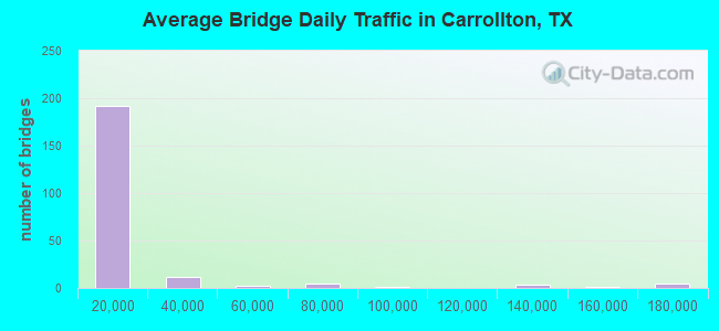
- 3,696,418Total average daily traffic
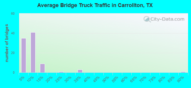
- 196,233Total average daily truck traffic
- National Bridge Inventory (NBI) Registered Bridges for Carrollton
- No street view available for this location
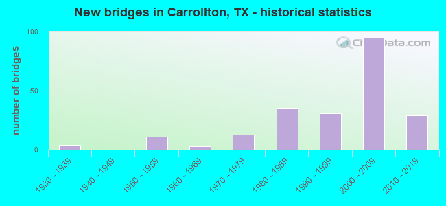
- New bridges - historical statistics
- 41930-1939
- 111950-1959
- 31960-1969
- 131970-1979
- 351980-1989
- 311990-1999
- 952000-2009
- 292010-2019
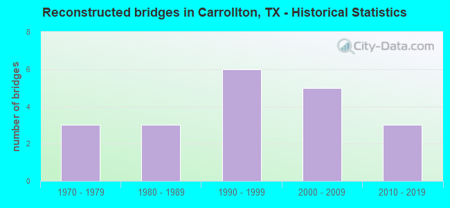
- Reconstructed bridges - Historical Statistics
- 31970-1979
- 31980-1989
- 61990-1999
- 52000-2009
- 32010-2019
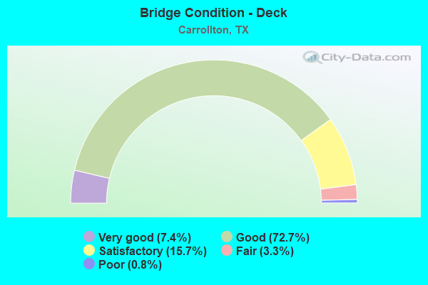
- Bridge Condition - Deck
- 7.4%Very good
- 72.7%Good
- 15.7%Satisfactory
- 3.3%Fair
- 0.8%Poor
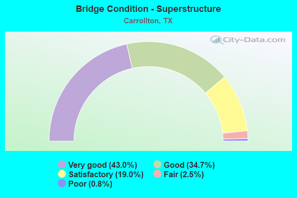
- Bridge Condition - Superstructure
- 43.0%Very good
- 34.7%Good
- 19.0%Satisfactory
- 2.5%Fair
- 0.8%Poor
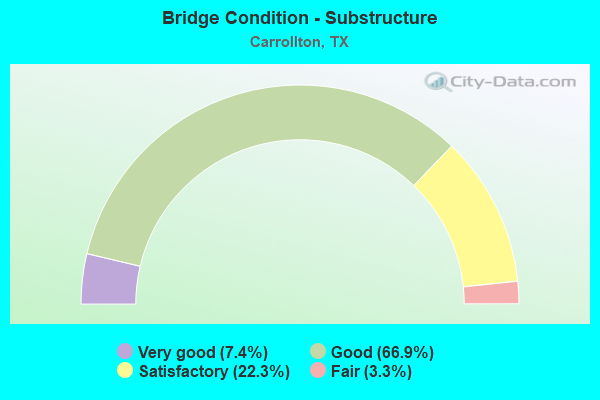
- Bridge Condition - Substructure
- 7.4%Very good
- 66.9%Good
- 22.3%Satisfactory
- 3.3%Fair
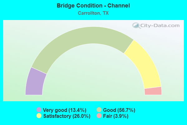
- Bridge Condition - Channel
- 13.4%Very good
- 56.7%Good
- 26.0%Satisfactory
- 3.9%Fair
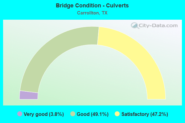
- Bridge Condition - Culverts
- 3.8%Very good
- 49.1%Good
- 47.2%Satisfactory
Find on map >> Show street view
Structure Number: 180570H01570004, Location: 0.1 MI S OF KELLER SPRING (Lat: 32.968653, Lng: -96.890169), Route carried "on" structure: City street , Year Built: 1930, Year Reconstructed: 1987, Status: Open, Structure Length: 1.31m (4.30ft), Average Daily Traffic: 36,930 (year 2013), Average Future Daily Traffic: 57,300 (year 2033), Features Intersected: HUTTON BRANCH, Facility Carried by Structure: JOSEY LANE
Minimum Vertical Clearance: 30+ m (98+ ft), Kilometerpoint: 3.460, Lanes on structure: 6, Owner: City or Municipal Highway Agency, Approaching Roadway Width: 20.1m (65.9ft), Skew: 29 degrees, Material/Design: Concrete, Design/Construction: Culvert, Number Of Spans In Main Unit: 4, Length of Maximum Span: 3.0m (9.8ft), Curb or Sidewalk Widths: Left: 2.0m (6.6ft), Right: 1.8m (5.9ft), Curb-To-Curb Width: 20.1m (65.9ft), Out-to-Out Width: 29.0m (95.1ft)
Condition: Channel: Good, Culverts: Satisfactory, Operating Rating: 32.7 metric tons, Method Used To Determine Operating Rating: Field evaluation and documented engineering judgment, Inventory Rating: 24.5 metric tons, Method Used To Determine Inventory Rating: Field evaluation and documented engineering judgment, Structural Evaluation: Equal to present minimum criteria, Deck Geometry: High priority of replacement, Waterway Adequacy: Somewhat better than minimum adequacy, Approach Roadway Alignment: Equal to present desirable criteria, Length Of Structure Improvement: 1.31m (4.30ft), Designated Inspection Frequency: Every 24 months, Inspection Date: April 2021, Bridge Improvement Cost: $6,000, Roadway Improvement Cost: $2,000, Total Project Cost: $8,000, Deck Structure Type: Concrete Cast-file-Place
Find on map >> Show street view
Structure Number: 180570H01590001, Location: 1.1 MI E OF JOSEY LN (Lat: 32.971250, Lng: -96.872508), Route carried "on" structure: City street , Year Built: 1990, Status: Open, Structure Length: 1.16m (3.81ft), Average Daily Traffic: 6,180 (year 2013), Average Future Daily Traffic: 8,531 (year 2033), Features Intersected: TRIB OF HUTTON BRANCH, Facility Carried by Structure: KELLER SPRINGS RD
Minimum Vertical Clearance: 30+ m (98+ ft), Kilometerpoint: 1.835, Lanes on structure: 6, Owner: City or Municipal Highway Agency, Approaching Roadway Width: 20.1m (65.9ft), Skew: 23 degrees, Material/Design: Concrete, Design/Construction: Culvert, Number Of Spans In Main Unit: 3, Length of Maximum Span: 3.0m (9.8ft), Curb or Sidewalk Widths: Left: 1.2m (3.9ft), Right: 0.0m
Condition: Channel: Fair, Culverts: Satisfactory, Operating Rating: 32.7 metric tons, Method Used To Determine Operating Rating: Field evaluation and documented engineering judgment, Inventory Rating: 24.5 metric tons, Method Used To Determine Inventory Rating: Field evaluation and documented engineering judgment, Structural Evaluation: Equal to present minimum criteria, Waterway Adequacy: Superior to present desirable criteria, Approach Roadway Alignment: Equal to present desirable criteria, Length Of Structure Improvement: 1.10m (3.61ft), Designated Inspection Frequency: Every 24 months, Inspection Date: Febuary 2021, Bridge Improvement Cost: $5,000, Roadway Improvement Cost: $1,000, Total Project Cost: $6,000
Find on map >> Show street view
Structure Number: 180570H01590002, Location: 0.25 MI E OF JOSEY LN (Lat: 32.971478, Lng: -96.886569), Route carried "on" structure: City street , Year Built: 1985, Status: Open, Structure Length: 1.89m (6.20ft), Average Daily Traffic: 16,686 (year 2019), Average Future Daily Traffic: 12,530 (year 2033), Design Load: HS 20, Features Intersected: HUTTON BRANCH, Facility Carried by Structure: KELLER SPRINGS RD
Minimum Vertical Clearance: 30+ m (98+ ft), Kilometerpoint: 1.891, Lanes on structure: 6, Owner: City or Municipal Highway Agency, Approaching Roadway Width: 20.1m (65.9ft), Skew: 24 degrees, Material/Design: Concrete, Design/Construction: Culvert, Number Of Spans In Main Unit: 4, Length of Maximum Span: 4.3m (14.1ft), Curb or Sidewalk Widths: Left: 1.2m (3.9ft), Right: 1.2m (3.9ft)
Condition: Channel: Good, Culverts: Satisfactory, Operating Rating: 39.9 metric tons, Method Used To Determine Operating Rating: Load Factor (LF), Inventory Rating: 23.6 metric tons, Method Used To Determine Inventory Rating: Load Factor (LF), Structural Evaluation: Somewhat better than minimum adequacy, Waterway Adequacy: Superior to present desirable criteria, Approach Roadway Alignment: Equal to present desirable criteria, Designated Inspection Frequency: Every 24 months, Inspection Date: Febuary 2021
Find on map >> Show street view
Structure Number: 180570H01590005, Location: 0.7 MI E OF OLD DENTON RD (Lat: 32.968217, Lng: -96.899703), Route carried "on" structure: City street , Year Built: 1986, Status: Open, Structure Length: 0.67m (2.20ft), Average Daily Traffic: 12,921 (year 2013), Average Future Daily Traffic: 20,100 (year 2033), Features Intersected: TRIB OF HUTTON BRANCH, Facility Carried by Structure: KELLER SPRINGS RD
Minimum Vertical Clearance: 30+ m (98+ ft), Kilometerpoint: 13.197, Lanes on structure: 8, Owner: City or Municipal Highway Agency, Approaching Roadway Width: 20.1m (65.9ft), Skew: 29 degrees, Material/Design: Concrete, Design/Construction: Culvert, Number Of Spans In Main Unit: 2, Length of Maximum Span: 3.0m (9.8ft), Curb or Sidewalk Widths: Left: 1.2m (3.9ft), Right: 1.2m (3.9ft)
Condition: Channel: Satisfactory, Culverts: Satisfactory, Operating Rating: 32.7 metric tons, Method Used To Determine Operating Rating: Field evaluation and documented engineering judgment, Inventory Rating: 24.5 metric tons, Method Used To Determine Inventory Rating: Field evaluation and documented engineering judgment, Structural Evaluation: Equal to present minimum criteria, Waterway Adequacy: Superior to present desirable criteria, Approach Roadway Alignment: Equal to present desirable criteria, Length Of Structure Improvement: 0.64m (2.10ft), Designated Inspection Frequency: Every 24 months, Inspection Date: Febuary 2021, Bridge Improvement Cost: $14,000, Roadway Improvement Cost: $4,000, Total Project Cost: $18,000
Find on map >> Show street view
Structure Number: 180570H01590006, Location: 0.2 MI W OF MIDWAY RD (Lat: 32.968872, Lng: -96.847142), Route carried "on" structure: City street , Year Built: 1976, Status: Open, Structure Length: 2.01m (6.59ft), Average Daily Traffic: 6,180 (year 2013), Average Future Daily Traffic: 8,531 (year 2033), Features Intersected: TRIB OF HUTTON BRANCH, Facility Carried by Structure: KELLER SPRINGS RD
Minimum Vertical Clearance: 30+ m (98+ ft), Kilometerpoint: 4.184, Lanes on structure: 4, Owner: City or Municipal Highway Agency, Approaching Roadway Width: 14.6m (47.9ft), Skew: 21 degrees, Material/Design: Concrete, Design/Construction: Culvert, Number Of Spans In Main Unit: 6, Length of Maximum Span: 3.0m (9.8ft), Curb or Sidewalk Widths: Left: 1.7m (5.6ft), Right: 1.5m (4.9ft), Curb-To-Curb Width: 14.6m (47.9ft), Out-to-Out Width: 30.5m (100.1ft)
Condition: Channel: Satisfactory, Culverts: Good, Operating Rating: 32.7 metric tons, Method Used To Determine Operating Rating: Field evaluation and documented engineering judgment, Inventory Rating: 24.5 metric tons, Method Used To Determine Inventory Rating: Field evaluation and documented engineering judgment, Structural Evaluation: Equal to present minimum criteria, Deck Geometry: High priority of replacement, Waterway Adequacy: Superior to present desirable criteria, Approach Roadway Alignment: Equal to present desirable criteria, Length Of Structure Improvement: 2.01m (6.59ft), Designated Inspection Frequency: Every 24 months, Inspection Date: Febuary 2021, Bridge Improvement Cost: $6,000, Roadway Improvement Cost: $2,000, Total Project Cost: $8,000, Deck Structure Type: Concrete Cast-file-Place, Wearing Surface/Protective System: Wearing Surface: Monolithic Concrete
Find on map >> Show street view
Structure Number: 180570H01590007, Location: 0.1 MI E OF MARSH LN (Lat: 32.971228, Lng: -96.852953), Route carried "on" structure: City street , Year Built: 1998, Status: Open, Structure Length: 1.71m (5.61ft), Average Daily Traffic: 6,180 (year 2013), Average Future Daily Traffic: 8,531 (year 2033), Features Intersected: TRIB OF HUTTON BRANCH, Facility Carried by Structure: KELLER SPRINGS RD
Minimum Vertical Clearance: 30+ m (98+ ft), Kilometerpoint: 3.380, Lanes on structure: 4, Owner: City or Municipal Highway Agency, Approaching Roadway Width: 14.3m (46.9ft), Skew: 21 degrees, Material/Design: Concrete, Design/Construction: Culvert, Number Of Spans In Main Unit: 5, Length of Maximum Span: 3.0m (9.8ft), Curb or Sidewalk Widths: Left: 2.5m (8.2ft), Right: 2.2m (7.2ft)
Condition: Channel: Good, Culverts: Good, Operating Rating: 32.7 metric tons, Method Used To Determine Operating Rating: Field evaluation and documented engineering judgment, Inventory Rating: 24.5 metric tons, Method Used To Determine Inventory Rating: Field evaluation and documented engineering judgment, Structural Evaluation: Equal to present minimum criteria, Waterway Adequacy: Equal to present minimum criteria, Approach Roadway Alignment: Equal to present desirable criteria, Length Of Structure Improvement: 1.71m (5.61ft), Designated Inspection Frequency: Every 24 months, Inspection Date: Febuary 2021, Bridge Improvement Cost: $5,000, Roadway Improvement Cost: $1,000, Total Project Cost: $6,000
Find on map >> Show street view
Structure Number: 180570H01595001, Location: 0.1 MI S OF TRINITY MILLS (Lat: 32.982872, Lng: -96.869139), Route carried "on" structure: City street , Year Built: 1976, Status: Open, Structure Length: 1.68m (5.51ft), Average Daily Traffic: 2,970 (year 2013), Average Future Daily Traffic: 4,000 (year 2033), Features Intersected: HUTTON BRANCH, Facility Carried by Structure: KELLY BLVD
Minimum Vertical Clearance: 30+ m (98+ ft), Kilometerpoint: 3.396, Lanes on structure: 5, Owner: City or Municipal Highway Agency, Approaching Roadway Width: 14.6m (47.9ft), Skew: 25 degrees, Material/Design: Concrete, Design/Construction: Culvert, Number Of Spans In Main Unit: 4, Length of Maximum Span: 2.4m (7.9ft), Curb or Sidewalk Widths: Left: 1.5m (4.9ft), Right: 1.5m (4.9ft)
Condition: Channel: Good, Culverts: Satisfactory, Operating Rating: 32.7 metric tons, Method Used To Determine Operating Rating: Field evaluation and documented engineering judgment, Inventory Rating: 24.5 metric tons, Method Used To Determine Inventory Rating: Field evaluation and documented engineering judgment, Structural Evaluation: Equal to present minimum criteria, Waterway Adequacy: Better than present minimum criteria, Approach Roadway Alignment: Equal to present desirable criteria, Designated Inspection Frequency: Every 24 months, Inspection Date: April 2021
Find on map >> Show street view
Structure Number: 180570H01595002, Location: 0.18 MI S KELLER SPRINGS (Lat: 32.968353, Lng: -96.877928), Route carried "on" structure: City street , Year Built: 1976, Year Reconstructed: 1986, Status: Open, Structure Length: 0.94m (3.08ft), Average Daily Traffic: 6,180 (year 2013), Average Future Daily Traffic: 10,000 (year 2033), Features Intersected: TRIB OF HUTTON BRANCH, Facility Carried by Structure: KELLY BLVD
Minimum Vertical Clearance: 30+ m (98+ ft), Kilometerpoint: 0.805, Lanes on structure: 4, Owner: City or Municipal Highway Agency, Approaching Roadway Width: 13.4m (44.0ft), Skew: 3 degrees, Material/Design: Concrete, Design/Construction: Culvert, Number Of Spans In Main Unit: 3, Length of Maximum Span: 2.4m (7.9ft), Curb or Sidewalk Widths: Left: 2.3m (7.5ft), Right: 1.6m (5.2ft), Curb-To-Curb Width: 13.4m (44.0ft), Out-to-Out Width: 17.8m (58.4ft)
Condition: Channel: Good, Culverts: Good, Operating Rating: 32.7 metric tons, Method Used To Determine Operating Rating: Field evaluation and documented engineering judgment, Inventory Rating: 24.5 metric tons, Method Used To Determine Inventory Rating: Field evaluation and documented engineering judgment, Structural Evaluation: Equal to present minimum criteria, Deck Geometry: High priority of replacement, Waterway Adequacy: Equal to present minimum criteria, Approach Roadway Alignment: Equal to present desirable criteria, Length Of Structure Improvement: 0.94m (3.08ft), Designated Inspection Frequency: Every 24 months, Inspection Date: Febuary 2021, Bridge Improvement Cost: $3,000, Roadway Improvement Cost: $1,000, Total Project Cost: $4,000, Deck Structure Type: Concrete Cast-file-Place, Wearing Surface/Protective System: Wearing Surface: Monolithic Concrete
Find on map >> Show street view
Structure Number: 180570H01595003, Location: 0.25 MI S KELLER SPRINGS (Lat: 32.967411, Lng: -96.877961), Route carried "on" structure: City street , Year Built: 1976, Year Reconstructed: 1986, Status: Open, Structure Length: 1.89m (6.20ft), Average Daily Traffic: 6,180 (year 2013), Average Future Daily Traffic: 10,000 (year 2033), Features Intersected: TRIB OF HUTTON BRANCH, Facility Carried by Structure: KELLY BLVD
Minimum Vertical Clearance: 30+ m (98+ ft), Kilometerpoint: 3.219, Lanes on structure: 4, Owner: City or Municipal Highway Agency, Approaching Roadway Width: 13.4m (44.0ft), Skew: 3 degrees, Material/Design: Concrete, Design/Construction: Culvert, Number Of Spans In Main Unit: 5, Length of Maximum Span: 3.0m (9.8ft), Curb or Sidewalk Widths: Left: 2.3m (7.5ft), Right: 1.8m (5.9ft), Curb-To-Curb Width: 13.5m (44.3ft), Out-to-Out Width: 18.1m (59.4ft)
Condition: Channel: Good, Culverts: Good, Operating Rating: 32.7 metric tons, Method Used To Determine Operating Rating: Field evaluation and documented engineering judgment, Inventory Rating: 24.5 metric tons, Method Used To Determine Inventory Rating: Field evaluation and documented engineering judgment, Structural Evaluation: Equal to present minimum criteria, Deck Geometry: High priority of replacement, Waterway Adequacy: High priority of corrective action, Approach Roadway Alignment: Equal to present desirable criteria, Length Of Structure Improvement: 1.89m (6.20ft), Designated Inspection Frequency: Every 24 months, Inspection Date: Febuary 2021, Bridge Improvement Cost: $5,000, Roadway Improvement Cost: $1,000, Total Project Cost: $6,000, Deck Structure Type: Concrete Cast-file-Place, Wearing Surface/Protective System: Wearing Surface: Monolithic Concrete
Find on map >> Show street view
Structure Number: 180570H01757003, Location: 0.45 MI N OF VALLEY VIEW (Lat: 32.923442, Lng: -96.925292), Route carried "on" structure: City street , Year Built: 1982, Status: Open, Structure Length: 15.36m (50.39ft), Average Daily Traffic: 24,616 (year 2014), Average Future Daily Traffic: 25,000 (year 2031), Features Intersected: COOKS BRANCH, Facility Carried by Structure: LUNA ROAD SB
Minimum Vertical Clearance: 30+ m (98+ ft), Kilometerpoint: 4.265, Lanes on structure: 3, Owner: City or Municipal Highway Agency, Approaching Roadway Width: 10.1m (33.1ft), Material/Design: Prestressed concrete, Design/Construction: Stringer/Multi-beam, Number Of Spans In Main Unit: 6, Length of Maximum Span: 25.6m (84.0ft), Curb-To-Curb Width: 11.9m (39.0ft), Out-to-Out Width: 12.4m (40.7ft)
Condition: Deck: Satisfactory, Superstructure: Good, Substructure: Satisfactory, Channel: Good, Operating Rating: 32.7 metric tons, Method Used To Determine Operating Rating: Field evaluation and documented engineering judgment, Inventory Rating: 24.5 metric tons, Method Used To Determine Inventory Rating: Field evaluation and documented engineering judgment, Structural Evaluation: Equal to present minimum criteria, Deck Geometry: High priority of corrective action, Waterway Adequacy: Superior to present desirable criteria, Approach Roadway Alignment: Equal to present minimum criteria, Length Of Structure Improvement: 15.24m (50.00ft), Designated Inspection Frequency: Every 24 months, Inspection Date: Febuary 2021, Bridge Improvement Cost: $39,000, Roadway Improvement Cost: $10,000, Total Project Cost: $49,000, Deck Structure Type: Concrete Cast-file-Place
Find on map >> Show street view
Structure Number: 180570H01757004, Location: 0.45 MI N OF VALLEY VIEW (Lat: 32.923444, Lng: -96.925147), Route carried "on" structure: City street , Year Built: 1982, Status: Open, Structure Length: 15.36m (50.39ft), Average Daily Traffic: 24,616 (year 2014), Average Future Daily Traffic: 30,000 (year 2033), Features Intersected: COOKS BRANCH, Facility Carried by Structure: LUNA RD NB
Minimum Vertical Clearance: 30+ m (98+ ft), Kilometerpoint: 4.265, Lanes on structure: 3, Owner: City or Municipal Highway Agency, Approaching Roadway Width: 10.1m (33.1ft), Material/Design: Prestressed concrete, Design/Construction: Stringer/Multi-beam, Number Of Spans In Main Unit: 6, Length of Maximum Span: 25.3m (83.0ft), Curb-To-Curb Width: 11.8m (38.7ft), Out-to-Out Width: 12.3m (40.4ft)
Condition: Deck: Satisfactory, Superstructure: Good, Substructure: Satisfactory, Channel: Satisfactory, Operating Rating: 32.7 metric tons, Method Used To Determine Operating Rating: Field evaluation and documented engineering judgment, Inventory Rating: 24.5 metric tons, Method Used To Determine Inventory Rating: Field evaluation and documented engineering judgment, Structural Evaluation: Equal to present minimum criteria, Deck Geometry: High priority of corrective action, Waterway Adequacy: Superior to present desirable criteria, Approach Roadway Alignment: Equal to present minimum criteria, Length Of Structure Improvement: 15.33m (50.30ft), Designated Inspection Frequency: Every 24 months, Inspection Date: Febuary 2021, Bridge Improvement Cost: $39,000, Roadway Improvement Cost: $10,000, Total Project Cost: $49,000, Deck Structure Type: Concrete Cast-file-Place
Find on map >> Show street view
Structure Number: 180570H01757006, Location: 0.3 MI S OF BELT LINE RD (Lat: 32.938242, Lng: -96.925219), Route carried "on" structure: City street , Year Built: 1982, Status: Open, Structure Length: 12.19m (39.99ft), Average Daily Traffic: 1,400 (year 2013), Average Future Daily Traffic: 5,000 (year 2033), Features Intersected: HUTTON BRANCH, Facility Carried by Structure: LUNA RD NB
Minimum Vertical Clearance: 30+ m (98+ ft), Kilometerpoint: 4.007, Lanes on structure: 3, Owner: City or Municipal Highway Agency, Approaching Roadway Width: 10.1m (33.1ft), Material/Design: Prestressed concrete, Design/Construction: Stringer/Multi-beam, Number Of Spans In Main Unit: 4, Length of Maximum Span: 30.5m (100.1ft), Curb-To-Curb Width: 11.9m (39.0ft), Out-to-Out Width: 12.3m (40.4ft)
Condition: Deck: Satisfactory, Superstructure: Good, Substructure: Good, Channel: Very good, Operating Rating: 32.7 metric tons, Method Used To Determine Operating Rating: Field evaluation and documented engineering judgment, Inventory Rating: 24.5 metric tons, Method Used To Determine Inventory Rating: Field evaluation and documented engineering judgment, Structural Evaluation: Equal to present minimum criteria, Deck Geometry: High priority of corrective action, Waterway Adequacy: Superior to present desirable criteria, Approach Roadway Alignment: Equal to present desirable criteria, Length Of Structure Improvement: 12.19m (39.99ft), Designated Inspection Frequency: Every 24 months, Inspection Date: Febuary 2021, Bridge Improvement Cost: $31,000, Roadway Improvement Cost: $8,000, Total Project Cost: $39,000, Deck Structure Type: Concrete Cast-file-Place
Find on map >> Show street view
Structure Number: 180570H0175701, Location: 0.3 MI S OF BELT LINE RD (Lat: 32.947519, Lng: -96.925169), Route carried "on" structure: City street , Year Built: 1986, Status: Open, Structure Length: 12.19m (39.99ft), Average Daily Traffic: 1,400 (year 2013), Average Future Daily Traffic: 5,000 (year 2033), Features Intersected: HUTTON BRANCH, Facility Carried by Structure: LUNA RD SB
Minimum Vertical Clearance: 30+ m (98+ ft), Kilometerpoint: 6.920, Lanes on structure: 3, Owner: City or Municipal Highway Agency, Approaching Roadway Width: 10.1m (33.1ft), Material/Design: Prestressed concrete, Design/Construction: Stringer/Multi-beam, Number Of Spans In Main Unit: 4, Length of Maximum Span: 30.5m (100.1ft), Curb-To-Curb Width: 11.9m (39.0ft), Out-to-Out Width: 12.3m (40.4ft)
Condition: Deck: Good, Superstructure: Good, Substructure: Satisfactory, Channel: Good, Operating Rating: 32.7 metric tons, Method Used To Determine Operating Rating: Field evaluation and documented engineering judgment, Inventory Rating: 24.5 metric tons, Method Used To Determine Inventory Rating: Field evaluation and documented engineering judgment, Structural Evaluation: Equal to present minimum criteria, Deck Geometry: High priority of corrective action, Waterway Adequacy: Superior to present desirable criteria, Approach Roadway Alignment: Equal to present desirable criteria, Length Of Structure Improvement: 12.19m (39.99ft), Designated Inspection Frequency: Every 24 months, Inspection Date: Febuary 2021, Bridge Improvement Cost: $31,000, Roadway Improvement Cost: $8,000, Total Project Cost: $39,000, Deck Structure Type: Concrete Cast-file-Place
Find on map >> Show street view
Structure Number: 180570H01757011, Location: 0.1 MI N OF VALWOOD PKWY (Lat: 32.938289, Lng: -96.925278), Route carried "on" structure: City street , Year Built: 1982, Status: Open, Structure Length: 1.83m (6.00ft), Average Daily Traffic: 5,725 (year 2013), Average Future Daily Traffic: 10,000 (year 2033), Design Load: HS 20, Features Intersected: TRIB OF HUTTON BRANCH, Facility Carried by Structure: LUNA RD
Minimum Vertical Clearance: 30+ m (98+ ft), Kilometerpoint: 7.564, Lanes on structure: 6, Owner: City or Municipal Highway Agency, Approaching Roadway Width: 20.1m (65.9ft), Skew: 23 degrees, Material/Design: Concrete, Design/Construction: Culvert, Number Of Spans In Main Unit: 5, Length of Maximum Span: 3.4m (11.2ft)
Condition: Channel: Good, Culverts: Satisfactory, Operating Rating: 39.9 metric tons, Method Used To Determine Operating Rating: Load Factor (LF), Inventory Rating: 23.6 metric tons, Method Used To Determine Inventory Rating: Load Factor (LF), Structural Evaluation: Somewhat better than minimum adequacy, Waterway Adequacy: Superior to present desirable criteria, Approach Roadway Alignment: Equal to present desirable criteria, Length Of Structure Improvement: 1.83m (6.00ft), Designated Inspection Frequency: Every 24 months, Inspection Date: Febuary 2021, Bridge Improvement Cost: $8,000, Roadway Improvement Cost: $2,000, Total Project Cost: $10,000
Find on map >> Show street view
Structure Number: 180570H01763001, Location: 50' N OF TRINITY MILLS EB (Lat: 32.982922, Lng: -96.925428), Route carried "on" structure: City street , Year Built: 2001, Status: Open, Structure Length: 0.70m (2.30ft), Average Daily Traffic: 5,000 (year 2013), Average Future Daily Traffic: 6,000 (year 2033), Features Intersected: SOUTH DRAINAGE DITCH, Facility Carried by Structure: MACARTHUR/BLANTON
Minimum Vertical Clearance: 5.28m (17.32ft), Kilometerpoint: 0.014, Lanes on structure: 3, Owner: City or Municipal Highway Agency, Approaching Roadway Width: 12.2m (40.0ft), Skew: 29 degrees, Material/Design: Concrete, Design/Construction: Culvert, Number Of Spans In Main Unit: 4, Length of Maximum Span: 1.5m (4.9ft), Curb or Sidewalk Widths: Left: 1.5m (4.9ft), Right: 1.5m (4.9ft)
Condition: Channel: Good, Culverts: Good, Operating Rating: 32.7 metric tons, Method Used To Determine Operating Rating: Field evaluation and documented engineering judgment, Inventory Rating: 24.5 metric tons, Method Used To Determine Inventory Rating: Field evaluation and documented engineering judgment, Structural Evaluation: Equal to present minimum criteria, Waterway Adequacy: Better than present minimum criteria, Approach Roadway Alignment: Equal to present desirable criteria, Designated Inspection Frequency: Every 24 months, Inspection Date: Febuary 2021
Find on map >> Show street view
Structure Number: 180570H01763002, Location: 50' S OF TRINITY MILLS WB (Lat: 32.983383, Lng: -96.925383), Route carried "on" structure: City street , Year Built: 2001, Status: Open, Structure Length: 0.70m (2.30ft), Average Daily Traffic: 5,000 (year 2013), Average Future Daily Traffic: 6,000 (year 2033), Features Intersected: NORTH DRAINAGE DITCH, Facility Carried by Structure: MACARTHUR/BLANTON
Minimum Vertical Clearance: 5.82m (19.09ft), Kilometerpoint: 0.014, Lanes on structure: 3, Owner: City or Municipal Highway Agency, Approaching Roadway Width: 12.2m (40.0ft), Skew: 29 degrees, Material/Design: Concrete, Design/Construction: Culvert, Number Of Spans In Main Unit: 4, Length of Maximum Span: 1.5m (4.9ft), Curb or Sidewalk Widths: Left: 1.5m (4.9ft), Right: 1.5m (4.9ft)
Condition: Channel: Fair, Culverts: Good, Operating Rating: 32.7 metric tons, Method Used To Determine Operating Rating: Field evaluation and documented engineering judgment, Inventory Rating: 24.5 metric tons, Method Used To Determine Inventory Rating: Field evaluation and documented engineering judgment, Structural Evaluation: Equal to present minimum criteria, Waterway Adequacy: Better than present minimum criteria, Approach Roadway Alignment: Equal to present desirable criteria, Designated Inspection Frequency: Every 24 months, Inspection Date: March 2021
Find on map >> Show street view
Structure Number: 180570H0179503, Location: 0.75 MI N OF BELT LINE RD (Lat: 32.964494, Lng: -96.853622), Route carried "on" structure: City street , Year Built: 1986, Status: Open, Structure Length: 3.84m (12.60ft), Average Daily Traffic: 5,625 (year 2013), Average Future Daily Traffic: 8,000 (year 2033), Features Intersected: TRIB OF HUTTON BRANCH, Facility Carried by Structure: MARSH LANE NB
Minimum Vertical Clearance: 30+ m (98+ ft), Kilometerpoint: 4.345, Lanes on structure: 3, Owner: City or Municipal Highway Agency, Approaching Roadway Width: 10.1m (33.1ft), Skew: 2 degrees, Material/Design: Concrete, Design/Construction: Stringer/Multi-beam, Number Of Spans In Main Unit: 3, Length of Maximum Span: 12.8m (42.0ft), Curb or Sidewalk Widths: Left: 0.0m, Right: 1.7m (5.6ft), Curb-To-Curb Width: 10.1m (33.1ft), Out-to-Out Width: 12.9m (42.3ft)
Condition: Deck: Satisfactory, Superstructure: Satisfactory, Substructure: Good, Channel: Satisfactory, Operating Rating: 32.7 metric tons, Method Used To Determine Operating Rating: Field evaluation and documented engineering judgment, Inventory Rating: 24.5 metric tons, Method Used To Determine Inventory Rating: Field evaluation and documented engineering judgment, Structural Evaluation: Equal to present minimum criteria, Deck Geometry: High priority of replacement, Waterway Adequacy: Superior to present desirable criteria, Approach Roadway Alignment: Equal to present desirable criteria, Length Of Structure Improvement: 3.84m (12.60ft), Designated Inspection Frequency: Every 24 months, Inspection Date: Febuary 2021, Bridge Improvement Cost: $8,000, Roadway Improvement Cost: $2,000, Total Project Cost: $10,000, Deck Structure Type: Concrete Cast-file-Place
Find on map >> Show street view
Structure Number: 180570H01795031, Location: 0.75 MI N OF BELT LINE RD (Lat: 32.964486, Lng: -96.853656), Route carried "on" structure: City street , Year Built: 1986, Status: Open, Structure Length: 3.84m (12.60ft), Average Daily Traffic: 5,625 (year 2013), Average Future Daily Traffic: 8,000 (year 2033), Features Intersected: TRIB OF HUTTON BRANCH, Facility Carried by Structure: MARSH LANE SB
Minimum Vertical Clearance: 30+ m (98+ ft), Kilometerpoint: 2.736, Lanes on structure: 3, Owner: City or Municipal Highway Agency, Approaching Roadway Width: 10.1m (33.1ft), Skew: 2 degrees, Material/Design: Concrete, Design/Construction: Stringer/Multi-beam, Number Of Spans In Main Unit: 3, Length of Maximum Span: 12.8m (42.0ft), Curb or Sidewalk Widths: Left: 1.7m (5.6ft), Right: 0.0m, Curb-To-Curb Width: 10.1m (33.1ft), Out-to-Out Width: 12.9m (42.3ft)
Condition: Deck: Satisfactory, Superstructure: Satisfactory, Substructure: Satisfactory, Channel: Good, Operating Rating: 32.7 metric tons, Method Used To Determine Operating Rating: Field evaluation and documented engineering judgment, Inventory Rating: 24.5 metric tons, Method Used To Determine Inventory Rating: Field evaluation and documented engineering judgment, Structural Evaluation: Equal to present minimum criteria, Deck Geometry: High priority of replacement, Waterway Adequacy: Superior to present desirable criteria, Approach Roadway Alignment: Equal to present desirable criteria, Length Of Structure Improvement: 3.84m (12.60ft), Designated Inspection Frequency: Every 24 months, Inspection Date: Febuary 2021, Bridge Improvement Cost: $8,000, Roadway Improvement Cost: $2,000, Total Project Cost: $10,000, Deck Structure Type: Concrete Cast-file-Place
Find on map >> Show street view
Structure Number: 180570H01948001, Location: 0.2 MI N OF VALWOOD PKWY (Lat: 32.942267, Lng: -96.907525), Route carried "on" structure: City street , Year Built: 1980, Status: Open, Structure Length: 1.80m (5.91ft), Average Daily Traffic: 1,740 (year 2013), Average Future Daily Traffic: 3,096 (year 2033), Features Intersected: TRIB OF HUTTON BRANCH, Facility Carried by Structure: MONETARY LN
Minimum Vertical Clearance: 30+ m (98+ ft), Kilometerpoint: 0.579, Lanes on structure: 2, Owner: City or Municipal Highway Agency, Approaching Roadway Width: 12.2m (40.0ft), Skew: 2 degrees, Material/Design: Concrete, Design/Construction: Culvert, Number Of Spans In Main Unit: 5, Length of Maximum Span: 3.4m (11.2ft), Curb-To-Curb Width: 12.2m (40.0ft), Out-to-Out Width: 18.3m (60.0ft)
Condition: Channel: Good, Culverts: Satisfactory, Operating Rating: 32.7 metric tons, Method Used To Determine Operating Rating: Field evaluation and documented engineering judgment, Inventory Rating: 24.5 metric tons, Method Used To Determine Inventory Rating: Field evaluation and documented engineering judgment, Structural Evaluation: Equal to present minimum criteria, Deck Geometry: Better than present minimum criteria, Waterway Adequacy: Superior to present desirable criteria, Approach Roadway Alignment: Equal to present desirable criteria, Designated Inspection Frequency: Every 24 months, Inspection Date: Febuary 2021, Deck Structure Type: Concrete Cast-file-Place, Wearing Surface/Protective System: Wearing Surface: Monolithic Concrete
Find on map >> Show street view
Structure Number: 180570H01985001, Location: 0.5 MI S OF BELT LINE RD (Lat: 32.946417, Lng: -96.883819), Route carried "on" structure: City street , Year Built: 1967, Status: Open, Structure Length: 0.76m (2.49ft), Average Daily Traffic: 5,275 (year 2013), Average Future Daily Traffic: 8,190 (year 2033), Design Load: HS 20, Features Intersected: COOKS BRANCH, Facility Carried by Structure: NIX RD
Minimum Vertical Clearance: 30+ m (98+ ft), Kilometerpoint: 0.805, Lanes on structure: 2, Owner: City or Municipal Highway Agency, Approaching Roadway Width: 11.0m (36.1ft), Skew: 4 degrees, Material/Design: Concrete, Design/Construction: Culvert, Number Of Spans In Main Unit: 2, Length of Maximum Span: 2.4m (7.9ft), Curb or Sidewalk Widths: Left: 1.5m (4.9ft), Right: 1.8m (5.9ft)
Condition: Channel: Satisfactory, Culverts: Good, Operating Rating: 39.9 metric tons, Method Used To Determine Operating Rating: Load Factor (LF), Inventory Rating: 23.6 metric tons, Method Used To Determine Inventory Rating: Load Factor (LF), Structural Evaluation: Somewhat better than minimum adequacy, Waterway Adequacy: Better than present minimum criteria, Approach Roadway Alignment: Equal to present desirable criteria, Designated Inspection Frequency: Every 24 months, Inspection Date: Febuary 2021
Find on map >> Show street view
Structure Number: 180570H02495001, Location: 0.5 MI E OF DENTON DR (Lat: 32.965086, Lng: -96.898817), Route carried "on" structure: City street , Year Built: 1957, Status: Posted for load, Structure Length: 3.66m (12.01ft), Average Daily Traffic: 4,800 (year 2013), Average Future Daily Traffic: 6,000 (year 2033), Features Intersected: HUTTON BRANCH, Facility Carried by Structure: RYAN ST
Minimum Vertical Clearance: 30+ m (98+ ft), Kilometerpoint: 0.772, Lanes on structure: 2, Owner: City or Municipal Highway Agency, Approaching Roadway Width: 11.3m (37.1ft), Material/Design: Concrete, Design/Construction: Stringer/Multi-beam, Number Of Spans In Main Unit: 3, Length of Maximum Span: 12.2m (40.0ft), Curb or Sidewalk Widths: Left: 0.5m (1.6ft), Right: 0.5m (1.6ft), Curb-To-Curb Width: 8.4m (27.6ft), Out-to-Out Width: 9.4m (30.8ft)
Condition: Deck: Fair, Superstructure: Satisfactory, Substructure: Fair, Channel: Good, Operating Rating: 47.2 metric tons, Method Used To Determine Operating Rating: Load Factor (LF), Inventory Rating: 28.1 metric tons, Method Used To Determine Inventory Rating: Load Factor (LF), Structural Evaluation: Somewhat better than minimum adequacy, Deck Geometry: High priority of corrective action, Waterway Adequacy: Better than present minimum criteria, Approach Roadway Alignment: Equal to present desirable criteria, Bridge Posting: Required (Relationship of Operating Rating to Maximum Legal Load: 0.1 - 9.9% below), Length Of Structure Improvement: 3.66m (12.01ft), Designated Inspection Frequency: Every 24 months, Inspection Date: March 2021, Bridge Improvement Cost: $7,000, Roadway Improvement Cost: $2,000, Total Project Cost: $9,000, Deck Structure Type: Concrete Cast-file-Place, Wearing Surface/Protective System: Wearing Surface: Bituminous
Find on map >> Show street view
Structure Number: 180570H02560001, Location: 0.35 MI S OF PGBT EB FR (Lat: 32.979700, Lng: -96.884161), Route carried "on" structure: City street , Year Built: 1991, Status: Open, Structure Length: 1.92m (6.30ft), Average Daily Traffic: 2,640 (year 2019), Truck Traffic: 3%, Average Future Daily Traffic: 3,400 (year 2039), Design Load: HS 20, Features Intersected: Hutton Branch, Facility Carried by Structure: Scott Mill Rd
Minimum Vertical Clearance: 30+ m (98+ ft), Kilometerpoint: 0.563, Lanes on structure: 4, Owner: City or Municipal Highway Agency, Approaching Roadway Width: 13.4m (44.0ft), Skew: 5 degrees, Material/Design: Concrete, Design/Construction: Culvert, Number Of Spans In Main Unit: 4, Length of Maximum Span: 2.4m (7.9ft), Curb or Sidewalk Widths: Left: 2.0m (6.6ft), Right: 1.9m (6.2ft), Curb-To-Curb Width: 13.4m (44.0ft), Out-to-Out Width: 18.3m (60.0ft)
Condition: Channel: Good, Culverts: Good, Operating Rating: 39.9 metric tons, Method Used To Determine Operating Rating: Load Factor (LF), Inventory Rating: 23.6 metric tons, Method Used To Determine Inventory Rating: Load Factor (LF), Structural Evaluation: Equal to present minimum criteria, Deck Geometry: High priority of replacement, Waterway Adequacy: Equal to present minimum criteria, Approach Roadway Alignment: Equal to present desirable criteria, Designated Inspection Frequency: Every 24 months, Inspection Date: October 2020, Deck Structure Type: Concrete Cast-file-Place, Wearing Surface/Protective System: Wearing Surface: Monolithic Concrete
Find on map >> Show street view
Structure Number: 180570H02870001, Location: 50 FT N OF BALLANTRAE DR (Lat: 32.969364, Lng: -96.852972), Route carried "on" structure: City street , Year Built: 1995, Status: Open, Structure Length: 0.88m (2.89ft), Average Daily Traffic: 100 (year 2013), Average Future Daily Traffic: 150 (year 2033), Features Intersected: TRIB OF HUTTON BRANCH, Facility Carried by Structure: TARPLEY APT DR
Minimum Vertical Clearance: 30+ m (98+ ft), Kilometerpoint: 0.016, Lanes on structure: 2, Owner: City or Municipal Highway Agency, Approaching Roadway Width: 7.0m (23.0ft), Material/Design: Concrete, Design/Construction: Culvert, Number Of Spans In Main Unit: 3, Length of Maximum Span: 2.7m (8.9ft)
Condition: Channel: Satisfactory, Culverts: Good, Operating Rating: 32.7 metric tons, Method Used To Determine Operating Rating: Field evaluation and documented engineering judgment, Inventory Rating: 24.5 metric tons, Method Used To Determine Inventory Rating: Field evaluation and documented engineering judgment, Structural Evaluation: Equal to present minimum criteria, Waterway Adequacy: Better than present minimum criteria, Approach Roadway Alignment: Equal to present desirable criteria, Designated Inspection Frequency: Every 24 months, Inspection Date: April 2021
Find on map >> Show street view
Structure Number: 180570H03000001, Location: 0.1 MI E OF KELLY BLVD (Lat: 32.985072, Lng: -96.867403), Route carried "on" structure: City street , Year Built: 2000, Status: Open, Structure Length: 1.83m (6.00ft), Average Daily Traffic: 4,000 (year 2013), Average Future Daily Traffic: 6,000 (year 2033), Features Intersected: HUTTON BRANCH, Facility Carried by Structure: TRINITY MILLS EB
Minimum Vertical Clearance: 30+ m (98+ ft), Kilometerpoint: 0.161, Lanes on structure: 3, Owner: City or Municipal Highway Agency, Approaching Roadway Width: 12.2m (40.0ft), Material/Design: Concrete, Design/Construction: Culvert, Number Of Spans In Main Unit: 5, Length of Maximum Span: 3.0m (9.8ft)
Condition: Channel: Good, Culverts: Good, Operating Rating: 32.7 metric tons, Method Used To Determine Operating Rating: Field evaluation and documented engineering judgment, Inventory Rating: 24.5 metric tons, Method Used To Determine Inventory Rating: Field evaluation and documented engineering judgment, Structural Evaluation: Equal to present minimum criteria, Waterway Adequacy: Equal to present minimum criteria, Approach Roadway Alignment: Equal to present desirable criteria, Designated Inspection Frequency: Every 24 months, Inspection Date: March 2021
Find on map >> Show street view
Structure Number: 180570H03115001, Location: 0.1 MI S OF KELLER SPRING (Lat: 32.970264, Lng: -96.876578), Route carried "on" structure: City street , Year Built: 1972, Status: Open, Structure Length: 0.79m (2.59ft), Average Daily Traffic: 815 (year 2013), Average Future Daily Traffic: 1,270 (year 2033), Design Load: HS 20, Features Intersected: TRIB OF HUTTON BRANCH, Facility Carried by Structure: VIA DEL NORTE DR
Minimum Vertical Clearance: 30+ m (98+ ft), Kilometerpoint: 0.080, Lanes on structure: 2, Owner: City or Municipal Highway Agency, Approaching Roadway Width: 7.9m (25.9ft), Material/Design: Concrete, Design/Construction: Culvert, Number Of Spans In Main Unit: 3, Length of Maximum Span: 2.4m (7.9ft), Curb or Sidewalk Widths: Left: 1.7m (5.6ft), Right: 1.7m (5.6ft), Curb-To-Curb Width: 7.9m (25.9ft), Out-to-Out Width: 11.7m (38.4ft)
Condition: Channel: Satisfactory, Culverts: Satisfactory, Operating Rating: 39.9 metric tons, Method Used To Determine Operating Rating: Load Factor (LF), Inventory Rating: 23.6 metric tons, Method Used To Determine Inventory Rating: Load Factor (LF), Structural Evaluation: Equal to present minimum criteria, Deck Geometry: Somewhat better than minimum adequacy, Waterway Adequacy: Better than present minimum criteria, Approach Roadway Alignment: Equal to present desirable criteria, Designated Inspection Frequency: Every 24 months, Inspection Date: March 2021, Deck Structure Type: Concrete Cast-file-Place, Wearing Surface/Protective System: Wearing Surface: Monolithic Concrete
Find on map >> Show street view
Structure Number: 180570LD8694001, Location: 0.15 MI S OF PGBT EB FR (Lat: 32.980347, Lng: -96.915411), Route carried "on" structure: City street , Year Built: 1978, Status: Open, Structure Length: 0.67m (2.20ft), Average Daily Traffic: 1,500 (year 2020), Truck Traffic: 20%, Average Future Daily Traffic: 1,950 (year 2040), Design Load: HS 20, Features Intersected: Draw, Facility Carried by Structure: Camp Ave
Minimum Vertical Clearance: 30+ m (98+ ft), Kilometerpoint: 0.241, Lanes on structure: 2, Owner: City or Municipal Highway Agency, Approaching Roadway Width: 12.2m (40.0ft), Material/Design: Concrete, Design/Construction: Culvert, Number Of Spans In Main Unit: 2, Length of Maximum Span: 3.0m (9.8ft), Curb-To-Curb Width: 12.0m (39.4ft), Out-to-Out Width: 18.3m (60.0ft)
Condition: Channel: Satisfactory, Culverts: Satisfactory, Operating Rating: 39.9 metric tons, Method Used To Determine Operating Rating: Load Factor (LF), Inventory Rating: 23.6 metric tons, Method Used To Determine Inventory Rating: Load Factor (LF), Structural Evaluation: Equal to present minimum criteria, Deck Geometry: Equal to present minimum criteria, Waterway Adequacy: Better than present minimum criteria, Approach Roadway Alignment: Equal to present desirable criteria, Designated Inspection Frequency: Every 24 months, Inspection Date: October 2020, Deck Structure Type: Concrete Cast-file-Place, Wearing Surface/Protective System: Wearing Surface: Monolithic Concrete
Find on map >> Show street view
Structure Number: 180570LD9036001, Location: 0.4 MI W of Dickerson Pkw (Lat: 32.987264, Lng: -96.927158), Route carried "on" structure: City street , Year Built: 1980, Status: Open, Structure Length: 0.67m (2.20ft), Average Daily Traffic: 231 (year 2019), Truck Traffic: 3%, Average Future Daily Traffic: 231 (year 2039), Features Intersected: Drain, Facility Carried by Structure: Halsey Way
Minimum Vertical Clearance: 30+ m (98+ ft), Kilometerpoint: 0.644, Lanes on structure: 2, Owner: City or Municipal Highway Agency, Approaching Roadway Width: 12.2m (40.0ft), Material/Design: Concrete, Design/Construction: Culvert, Number Of Spans In Main Unit: 2, Length of Maximum Span: 3.0m (9.8ft), Curb-To-Curb Width: 12.2m (40.0ft), Out-to-Out Width: 18.3m (60.0ft)
Condition: Channel: Good, Culverts: Good, Operating Rating: 32.7 metric tons, Method Used To Determine Operating Rating: Field evaluation and documented engineering judgment, Inventory Rating: 24.5 metric tons, Method Used To Determine Inventory Rating: Field evaluation and documented engineering judgment, Structural Evaluation: Equal to present minimum criteria, Deck Geometry: Superior to present desirable criteria, Waterway Adequacy: Equal to present desirable criteria, Approach Roadway Alignment: Equal to present desirable criteria, Designated Inspection Frequency: Every 24 months, Inspection Date: March 2021, Wearing Surface/Protective System: Wearing Surface: Monolithic Concrete
Find on map >> Show street view
Structure Number: 180570P00100003, Location: 0.2 MI N KELLER SP. RD. (Lat: 32.972308, Lng: -96.842878), Route carried "on" structure: City street , Year Built: 1965, Year Reconstructed: 2001, Status: Open, Structure Length: 0.94m (3.08ft), Average Daily Traffic: 33,530 (year 2015), Truck Traffic: 3%, Average Future Daily Traffic: 46,942 (year 2037), Features Intersected: HUTTON BRANCH, Facility Carried by Structure: MIDWAY ROAD
Minimum Vertical Clearance: 30+ m (98+ ft), Kilometerpoint: 3.669, Lanes on structure: 6, Owner: City or Municipal Highway Agency, Approaching Roadway Width: 20.1m (65.9ft), Skew: 9 degrees, Material/Design: Concrete, Design/Construction: Culvert, Number Of Spans In Main Unit: 3, Length of Maximum Span: 2.7m (8.9ft)
Condition: Channel: Good, Culverts: Satisfactory, Operating Rating: 32.7 metric tons, Method Used To Determine Operating Rating: Field evaluation and documented engineering judgment, Inventory Rating: 24.5 metric tons, Method Used To Determine Inventory Rating: Field evaluation and documented engineering judgment, Structural Evaluation: Equal to present minimum criteria, Waterway Adequacy: Superior to present desirable criteria, Approach Roadway Alignment: Equal to present desirable criteria, Length Of Structure Improvement: 0.94m (3.08ft), Designated Inspection Frequency: Every 24 months, Inspection Date: March 2021, Bridge Improvement Cost: $2,000, Roadway Improvement Cost: $1,000, Total Project Cost: $3,000
Find on map >> Show street view
Structure Number: 180610019602027, Location: 0.30 MI NW OF DALLAS C/L (Lat: 32.990983, Lng: -96.943547), Route carried "on" structure: Interstate 35, Year Built: 1939, Year Reconstructed: 2016, Status: Open, Structure Length: 9.75m (31.99ft), Average Daily Traffic: 74,860 (year 2019), Truck Traffic: 7%, Average Future Daily Traffic: 107,150 (year 2033), Design Load: HS 20, Features Intersected: ELM FK TRINITY RIV REL 2
Minimum Vertical Clearance: 30+ m (98+ ft), Kilometerpoint: 2.039, Lanes on structure: 3, Owner: State Highway Agency, Approaching Roadway Width: 13.7m (44.9ft), Material/Design: Steel, Design/Construction: Stringer/Multi-beam, Number Of Spans In Main Unit: 8, Length of Maximum Span: 12.2m (40.0ft), Curb-To-Curb Width: 13.8m (45.3ft), Out-to-Out Width: 25.1m (82.3ft)
Condition: Deck: Good, Superstructure: Satisfactory, Substructure: Satisfactory, Channel: Good, Operating Rating: 54.4 metric tons, Method Used To Determine Operating Rating: Assigned rating based on Load Factor Design (LFD) reported in metric tons, Inventory Rating: 32.7 metric tons, Method Used To Determine Inventory Rating: Assigned rating based on Load Factor Design (LFD) reported in metric tons, Structural Evaluation: Equal to present minimum criteria, Deck Geometry: Meets minimum limits, Waterway Adequacy: Equal to present minimum criteria, Approach Roadway Alignment: Equal to present desirable criteria, Designated Inspection Frequency: Every 24 months, Inspection Date: November 2021, Deck Structure Type: Concrete Cast-file-Place, Wearing Surface/Protective System: Wearing Surface: Bituminous
Find on map >> Show street view
Structure Number: 180610019602084, Location: 0.30 MI NW OF DALLAS C/L (Lat: 32.990828, Lng: -96.943686), Route carried "on" structure: Interstate 35, Year Built: 1957, Year Reconstructed: 2007, Status: Open, Structure Length: 9.24m (30.31ft), Average Daily Traffic: 70,035 (year 2019), Truck Traffic: 7%, Average Future Daily Traffic: 107,150 (year 2033), Design Load: HS 20, Features Intersected: ELM FK TRINITY RIV REL 2
Minimum Vertical Clearance: 30+ m (98+ ft), Kilometerpoint: 2.042, Lanes on structure: 5, Owner: State Highway Agency, Approaching Roadway Width: 21.9m (71.9ft), Material/Design: Concrete, Design/Construction: Stringer/Multi-beam, Number Of Spans In Main Unit: 10, Length of Maximum Span: 9.1m (29.9ft), Curb-To-Curb Width: 21.9m (71.9ft), Out-to-Out Width: 23.4m (76.8ft)
Condition: Deck: Good, Superstructure: Good, Substructure: Good, Channel: Satisfactory, Operating Rating: 68.0 metric tons, Method Used To Determine Operating Rating: Load Factor (LF), Inventory Rating: 40.8 metric tons, Method Used To Determine Inventory Rating: Load Factor (LF), Structural Evaluation: Better than present minimum criteria, Deck Geometry: Meets minimum limits, Waterway Adequacy: Equal to present minimum criteria, Approach Roadway Alignment: Equal to present desirable criteria, Designated Inspection Frequency: Every 24 months, Inspection Date: November 2021, Deck Structure Type: Concrete Cast-file-Place, Wearing Surface/Protective System: Wearing Surface: Bituminous, Deck Protection: Epoxy Coated Reinforcing
Find on map >> Show street view
Structure Number: 180610019602225, Location: 1.10 MI NW OF DALLAS C/L (Lat: 32.998283, Lng: -96.955183), Route carried "on" structure: ServiceOther road 35, Year Built: 1982, Status: Open, Structure Length: 12.19m (39.99ft), Average Daily Traffic: 14,460 (year 2013), Truck Traffic: 8%, Average Future Daily Traffic: 20,780 (year 2033), Design Load: HS 20, Features Intersected: TIMBER CREEK
Minimum Vertical Clearance: 30+ m (98+ ft), Kilometerpoint: 3.323, Lanes on structure: 2, Owner: State Highway Agency, Approaching Roadway Width: 9.8m (32.2ft), Skew: 1 degrees, Material/Design: Prestressed concrete, Design/Construction: Stringer/Multi-beam, Number Of Spans In Main Unit: 5, Length of Maximum Span: 24.4m (80.1ft), Curb-To-Curb Width: 10.3m (33.8ft), Out-to-Out Width: 11.1m (36.4ft)
Condition: Deck: Satisfactory, Superstructure: Satisfactory, Substructure: Good, Channel: Satisfactory, Operating Rating: 54.4 metric tons, Method Used To Determine Operating Rating: Assigned rating based on Load Factor Design (LFD) reported in metric tons, Inventory Rating: 32.7 metric tons, Method Used To Determine Inventory Rating: Assigned rating based on Load Factor Design (LFD) reported in metric tons, Structural Evaluation: Equal to present minimum criteria, Deck Geometry: Meets minimum limits, Waterway Adequacy: Superior to present desirable criteria, Approach Roadway Alignment: Equal to present desirable criteria, Designated Inspection Frequency: Every 24 months, Inspection Date: October 2021, Deck Structure Type: Concrete Cast-file-Place
Find on map >> Show street view
Structure Number: 180610019602226, Location: 0.65 MI NW OF DALLAS C/L (Lat: 32.993364, Lng: -96.948694), Route carried "on" structure: ServiceOther road 35, Year Built: 1982, Status: Open, Structure Length: 6.86m (22.51ft), Average Daily Traffic: 6,450 (year 2013), Truck Traffic: 7%, Average Future Daily Traffic: 9,030 (year 2033), Design Load: HS 20, Features Intersected: ELM FORK TRINITY RIVER
Minimum Vertical Clearance: 30+ m (98+ ft), Kilometerpoint: 2.607, Lanes on structure: 2, Owner: State Highway Agency, Approaching Roadway Width: 9.8m (32.2ft), Material/Design: Prestressed concrete, Design/Construction: Stringer/Multi-beam, Number Of Spans In Main Unit: 3, Length of Maximum Span: 22.9m (75.1ft), Curb-To-Curb Width: 10.6m (34.8ft), Out-to-Out Width: 11.2m (36.7ft)
Condition: Deck: Satisfactory, Superstructure: Good, Substructure: Satisfactory, Channel: Satisfactory, Operating Rating: 54.4 metric tons, Method Used To Determine Operating Rating: Assigned rating based on Load Factor Design (LFD) reported in metric tons, Inventory Rating: 32.7 metric tons, Method Used To Determine Inventory Rating: Assigned rating based on Load Factor Design (LFD) reported in metric tons, Structural Evaluation: Equal to present minimum criteria, Deck Geometry: Somewhat better than minimum adequacy, Waterway Adequacy: Better than present minimum criteria, Approach Roadway Alignment: Equal to present desirable criteria, Designated Inspection Frequency: Every 24 months, Inspection Date: October 2021, Deck Structure Type: Concrete Cast-file-Place
Find on map >> Show street view
Structure Number: 180610019602288, Location: 0.25 MI NW OF DALLAS C/L (Lat: 32.990261, Lng: -96.943406), Route carried "on" structure: Ramp County highway , Year Built: 1995, Status: Open, Structure Length: 59.28m (194.49ft), Average Daily Traffic: 5,000 (year 2014), Truck Traffic: 2%, Average Future Daily Traffic: 6,000 (year 2034), Design Load: HS 20, Features Intersected: IH 35E & ELM FK REL 2, Facility Carried by Structure: FRANKFORD RD CONN
Minimum Vertical Clearance: 30+ m (98+ ft), Kilometerpoint: 13.362, Lanes on structure: 2, Lanes under structure: 18, Owner: State Highway Agency, Approaching Roadway Width: 17.1m (56.1ft), Skew: 39 degrees, Material/Design: Prestressed concrete, Design/Construction: Stringer/Multi-beam, Number Of Spans In Main Unit: 2, Number Of Approach Spans: 27, Length of Maximum Span: 36.0m (118.1ft), Curb-To-Curb Width: 16.2m (53.1ft), Out-to-Out Width: 17.1m (56.1ft)
Condition: Deck: Good, Superstructure: Very good, Substructure: Good, Channel: Good, Operating Rating: 54.4 metric tons, Method Used To Determine Operating Rating: Assigned rating based on Load Factor Design (LFD) reported in metric tons, Inventory Rating: 32.7 metric tons, Method Used To Determine Inventory Rating: Assigned rating based on Load Factor Design (LFD) reported in metric tons, Structural Evaluation: Better than present minimum criteria, Deck Geometry: Superior to present desirable criteria, Underclear: High priority of corrective action, Waterway Adequacy: Superior to present desirable criteria, Approach Roadway Alignment: Equal to present desirable criteria, Designated Inspection Frequency: Every 24 months, Inspection Date: November 2021, Deck Structure Type: Concrete Cast-file-Place
Find on map >> Show street view
Structure Number: 180610019602303, Location: 0.30 MI NW OF DALLAS C/L (Lat: 32.991164, Lng: -96.942822), Route carried "on" structure: ServiceOther road 35, Year Built: 1995, Year Reconstructed: 2015, Status: Open, Structure Length: 9.75m (31.99ft), Average Daily Traffic: 10,740 (year 2013), Truck Traffic: 8%, Average Future Daily Traffic: 15,040 (year 2033), Design Load: HS 20, Features Intersected: ELM FK TRINITY RIV REL 2
Minimum Vertical Clearance: 30+ m (98+ ft), Kilometerpoint: 14.957, Lanes on structure: 5, Owner: State Highway Agency, Approaching Roadway Width: 23.2m (76.1ft), Material/Design: Prestressed concrete, Design/Construction: Stringer/Multi-beam, Number Of Spans In Main Unit: 5, Length of Maximum Span: 19.5m (64.0ft), Curb-To-Curb Width: 23.2m (76.1ft), Out-to-Out Width: 25.0m (82.0ft)
Condition: Deck: Good, Superstructure: Good, Substructure: Good, Channel: Very good, Operating Rating: 54.4 metric tons, Method Used To Determine Operating Rating: Assigned rating based on Load Factor Design (LFD) reported in metric tons, Inventory Rating: 32.7 metric tons, Method Used To Determine Inventory Rating: Assigned rating based on Load Factor Design (LFD) reported in metric tons, Structural Evaluation: Better than present minimum criteria, Deck Geometry: Better than present minimum criteria, Waterway Adequacy: Superior to present desirable criteria, Approach Roadway Alignment: Equal to present desirable criteria, Designated Inspection Frequency: Every 24 months, Inspection Date: November 2021, Deck Structure Type: Concrete Cast-file-Place, Wearing Surface/Protective System: Deck Protection: Epoxy Coated Reinforcing
Find on map >> Show street view
Structure Number: 180610019602304, Location: 0.30 MI NW OF DALLAS C/L (Lat: 32.990461, Lng: -96.943386), Route carried "on" structure: ServiceOther road 35, Year Built: 1995, Status: Open, Structure Length: 9.75m (31.99ft), Average Daily Traffic: 14,607 (year 2014), Truck Traffic: 5%, Average Future Daily Traffic: 6,000 (year 2034), Design Load: HS 20, Features Intersected: ELM FK TRINITY RIV REL 2
Minimum Vertical Clearance: 30+ m (98+ ft), Kilometerpoint: 3.850, Lanes on structure: 2, Owner: State Highway Agency, Approaching Roadway Width: 9.8m (32.2ft), Material/Design: Prestressed concrete, Design/Construction: Stringer/Multi-beam, Number Of Spans In Main Unit: 5, Length of Maximum Span: 19.5m (64.0ft), Curb-To-Curb Width: 9.8m (32.2ft), Out-to-Out Width: 10.4m (34.1ft)
Condition: Deck: Good, Superstructure: Very good, Substructure: Good, Channel: Good, Operating Rating: 54.4 metric tons, Method Used To Determine Operating Rating: Assigned rating based on Load Factor Design (LFD) reported in metric tons, Inventory Rating: 32.7 metric tons, Method Used To Determine Inventory Rating: Assigned rating based on Load Factor Design (LFD) reported in metric tons, Structural Evaluation: Better than present minimum criteria, Deck Geometry: Meets minimum limits, Waterway Adequacy: Superior to present desirable criteria, Approach Roadway Alignment: Equal to present desirable criteria, Designated Inspection Frequency: Every 24 months, Inspection Date: November 2021, Deck Structure Type: Concrete Cast-file-Place, Wearing Surface/Protective System: Deck Protection: Epoxy Coated Reinforcing
Find on map >> Show street view
Structure Number: 180610019602311, Location: 0.30 MI SE OF SH 121 (Lat: 32.996042, Lng: -96.951550), Route carried "on" structure: ServiceOther road 35, Year Built: 2006, Status: Open, Structure Length: 7.35m (24.11ft), Average Daily Traffic: 5,470 (year 2013), Truck Traffic: 7%, Average Future Daily Traffic: 7,660 (year 2033), Design Load: HS 20, Features Intersected: ELM FK TRINITY RIV REL 3
Minimum Vertical Clearance: 30+ m (98+ ft), Kilometerpoint: 3.018, Lanes on structure: 2, Owner: State Highway Agency, Approaching Roadway Width: 12.2m (40.0ft), Material/Design: Prestressed concrete, Design/Construction: Stringer/Multi-beam, Number Of Spans In Main Unit: 3, Length of Maximum Span: 25.9m (85.0ft), Curb-To-Curb Width: 11.5m (37.7ft), Out-to-Out Width: 12.2m (40.0ft)
Condition: Deck: Good, Superstructure: Very good, Substructure: Good, Channel: Satisfactory, Operating Rating: 54.4 metric tons, Method Used To Determine Operating Rating: Assigned rating based on Load Factor Design (LFD) reported in metric tons, Inventory Rating: 32.7 metric tons, Method Used To Determine Inventory Rating: Assigned rating based on Load Factor Design (LFD) reported in metric tons, Structural Evaluation: Better than present minimum criteria, Deck Geometry: Equal to present minimum criteria, Waterway Adequacy: Superior to present desirable criteria, Approach Roadway Alignment: Equal to present desirable criteria, Designated Inspection Frequency: Every 24 months, Inspection Date: October 2021, Deck Structure Type: Concrete Precast Panels
Find on map >> Show street view
Structure Number: 18061001960249, Location: 1.1 MI. SE. OF SH 121 (Lat: 32.990950, Lng: -96.943656), Route carried "on" structure: Ramp Interstate 35, Year Built: 2017, Status: Open, Structure Length: 9.69m (31.79ft), Average Daily Traffic: 57,800 (year 2010), Truck Traffic: 7%, Average Future Daily Traffic: 80,600 (year 2030), Design Load: HL 93, Features Intersected: ELM FORK OVERFLOW
Minimum Vertical Clearance: 0.00m, Kilometerpoint: 0.000, Lanes on structure: 3, Owner: State Highway Agency, Maintenance Responsibility: Private, Approaching Roadway Width: 14.6m (47.9ft), Material/Design: Prestressed concrete, Design/Construction: Stringer/Multi-beam, Number Of Spans In Main Unit: 4, Length of Maximum Span: 27.4m (89.9ft), Curb-To-Curb Width: 14.6m (47.9ft), Out-to-Out Width: 15.2m (49.9ft)
Condition: Deck: Good, Superstructure: Very good, Substructure: Very good, Channel: Very good, Operating Rating: 54.4 metric tons, Method Used To Determine Operating Rating: Assigned ratings based on Load and Resistance Factor Design (LRFD) reported in metric tons, Inventory Rating: 32.7 metric tons, Method Used To Determine Inventory Rating: Assigned ratings based on Load and Resistance Factor Design (LRFD) reported in metric tons, Structural Evaluation: Equal to present desirable criteria, Deck Geometry: High priority of corrective action, Waterway Adequacy: Superior to present desirable criteria, Approach Roadway Alignment: Equal to present desirable criteria, Designated Inspection Frequency: Every 24 months, Inspection Date: November 2021, Deck Structure Type: Concrete Precast Panels, Wearing Surface/Protective System: Deck Protection: Epoxy Coated Reinforcing
Find on map >> Show street view
Structure Number: 180610019602493, Location: 0.8 MI. SE. OF SH 121 (Lat: 32.994111, Lng: -96.948350), Route carried "on" structure: ServiceInterstate 35, Year Built: 2017, Status: Open, Structure Length: 11.89m (39.01ft), Average Daily Traffic: 17,700 (year 2010), Truck Traffic: 7%, Average Future Daily Traffic: 25,400 (year 2030), Design Load: HL 93, Features Intersected: ELM FORK
Minimum Vertical Clearance: 0.00m, Kilometerpoint: 0.000, Lanes on structure: 2, Owner: State Highway Agency, Maintenance Responsibility: Private, Approaching Roadway Width: 8.5m (27.9ft), Material/Design: Prestressed concrete, Design/Construction: Stringer/Multi-beam, Number Of Spans In Main Unit: 3, Number Of Approach Spans: 1, Length of Maximum Span: 32.0m (105.0ft), Curb-To-Curb Width: 8.5m (27.9ft), Out-to-Out Width: 9.1m (29.9ft)
Condition: Deck: Good, Superstructure: Very good, Substructure: Good, Channel: Good, Operating Rating: 54.4 metric tons, Method Used To Determine Operating Rating: Assigned ratings based on Load and Resistance Factor Design (LRFD) reported in metric tons, Inventory Rating: 32.7 metric tons, Method Used To Determine Inventory Rating: Assigned ratings based on Load and Resistance Factor Design (LRFD) reported in metric tons, Structural Evaluation: Better than present minimum criteria, Deck Geometry: High priority of corrective action, Waterway Adequacy: Superior to present desirable criteria, Approach Roadway Alignment: Equal to present desirable criteria, Designated Inspection Frequency: Every 24 months, Inspection Date: November 2021, Deck Structure Type: Concrete Precast Panels, Wearing Surface/Protective System: Deck Protection: Epoxy Coated Reinforcing
Find on map >> Show street view
Structure Number: 180610019603503, Location: 0.2 MI S. of GWB/I35E JCT (Lat: 32.978628, Lng: -96.926325), Route carried "on" structure: Ramp Interstate 35, Year Built: 2018, Status: Open, Structure Length: 16.67m (54.69ft), Average Daily Traffic: 7,095 (year 2017), Truck Traffic: 3%, Average Future Daily Traffic: 9,930 (year 2037), Design Load: HL 93, Features Intersected: IH 35E NB FR, Facility Carried by Structure: Dickerson SE Ramp
Minimum Vertical Clearance: 30+ m (98+ ft), Kilometerpoint: 0.000, Lanes on structure: 1, Lanes under structure: 2, Base Highway Network: Yes, Owner: State Highway Agency, Approaching Roadway Width: 7.9m (25.9ft), Skew: 9 degrees, Material/Design: Prestressed concrete, Design/Construction: Stringer/Multi-beam, Number Of Spans In Main Unit: 7, Number Of Approach Spans: 2, Length of Maximum Span: 21.9m (71.9ft), Curb-To-Curb Width: 7.9m (25.9ft), Out-to-Out Width: 8.5m (27.9ft)
Condition: Deck: Good, Superstructure: Very good, Substructure: Good, Operating Rating: 54.4 metric tons, Method Used To Determine Operating Rating: Assigned ratings based on Load and Resistance Factor Design (LRFD) reported in metric tons, Inventory Rating: 32.7 metric tons, Method Used To Determine Inventory Rating: Assigned ratings based on Load and Resistance Factor Design (LRFD) reported in metric tons, Structural Evaluation: Better than present minimum criteria, Deck Geometry: Equal to present desirable criteria, Underclear: Equal to present minimum criteria, Approach Roadway Alignment: Equal to present desirable criteria, Designated Inspection Frequency: Every 24 months, Inspection Date: November 2020, Deck Structure Type: Concrete Cast-file-Place, Wearing Surface/Protective System: Deck Protection: Epoxy Coated Reinforcing
Find on map >> Show street view
Structure Number: 180610019603504, Location: 0.2 MI S. of GWB/I35E JCT (Lat: 32.977897, Lng: -96.927367), Route carried "on" structure: Ramp Interstate 35, Year Built: 2018, Status: Open, Structure Length: 19.20m (62.99ft), Average Daily Traffic: 11,968 (year 2017), Average Future Daily Traffic: 16,760 (year 2037), Design Load: HL 93, Features Intersected: IH 35E R.O.W., Facility Carried by Structure: Dickerson SW Ramp
Minimum Vertical Clearance: 30+ m (98+ ft), Kilometerpoint: 0.000, Lanes on structure: 1, Base Highway Network: Yes, Owner: State Highway Agency, Approaching Roadway Width: 7.9m (25.9ft), Material/Design: Prestressed concrete, Design/Construction: Stringer/Multi-beam, Number Of Spans In Main Unit: 9, Length of Maximum Span: 21.9m (71.9ft), Curb-To-Curb Width: 7.8m (25.6ft), Out-to-Out Width: 8.5m (27.9ft)
Condition: Deck: Good, Superstructure: Very good, Substructure: Very good, Operating Rating: 54.4 metric tons, Method Used To Determine Operating Rating: Assigned ratings based on Load and Resistance Factor Design (LRFD) reported in metric tons, Inventory Rating: 32.7 metric tons, Method Used To Determine Inventory Rating: Assigned ratings based on Load and Resistance Factor Design (LRFD) reported in metric tons, Structural Evaluation: Equal to present desirable criteria, Deck Geometry: Better than present minimum criteria, Approach Roadway Alignment: Equal to present desirable criteria, Designated Inspection Frequency: Every 24 months, Inspection Date: November 2020, Deck Structure Type: Concrete Cast-file-Place, Wearing Surface/Protective System: Deck Protection: Epoxy Coated Reinforcing
Find on map >> Show street view
Structure Number: 180610019603505, Location: 0.2 MI S. of GWB/I35E JCT (Lat: 32.979394, Lng: -96.927042), Route carried "on" structure: Ramp Interstate 35, Year Built: 2018, Status: Open, Structure Length: 12.68m (41.60ft), Average Daily Traffic: 10,824 (year 2017), Average Future Daily Traffic: 15,150 (year 2037), Design Load: HL 93, Features Intersected: IH 35E NB FR, Facility Carried by Structure: Dickerson NE Ramp
Minimum Vertical Clearance: 30+ m (98+ ft), Kilometerpoint: 0.000, Lanes on structure: 1, Lanes under structure: 2, Base Highway Network: Yes, Owner: State Highway Agency, Approaching Roadway Width: 7.9m (25.9ft), Skew: 9 degrees, Material/Design: Prestressed concrete, Design/Construction: Stringer/Multi-beam, Number Of Spans In Main Unit: 6, Number Of Approach Spans: 1, Length of Maximum Span: 20.1m (65.9ft), Curb-To-Curb Width: 7.9m (25.9ft), Out-to-Out Width: 8.5m (27.9ft)
Condition: Deck: Good, Superstructure: Very good, Substructure: Good, Operating Rating: 54.4 metric tons, Method Used To Determine Operating Rating: Assigned ratings based on Load and Resistance Factor Design (LRFD) reported in metric tons, Inventory Rating: 32.7 metric tons, Method Used To Determine Inventory Rating: Assigned ratings based on Load and Resistance Factor Design (LRFD) reported in metric tons, Structural Evaluation: Better than present minimum criteria, Deck Geometry: Equal to present desirable criteria, Underclear: Equal to present minimum criteria, Approach Roadway Alignment: Equal to present desirable criteria, Designated Inspection Frequency: Every 24 months, Inspection Date: November 2020, Deck Structure Type: Concrete Cast-file-Place, Wearing Surface/Protective System: Deck Protection: Epoxy Coated Reinforcing