Bridge Statistics for Carrollton, Texas (TX)
Condition, Traffic, Stress, Structural Evaluation, Project Costs
- National Bridge Inventory (NBI) Statistics
- 221Number of bridges
- 9,108ft / 2,776mTotal length
- $757,000Total costs
- 3,696,418Total average daily traffic
- 196,233Total average daily truck traffic
- National Bridge Inventory (NBI) Registered Bridges for Carrollton
- No street view available for this location
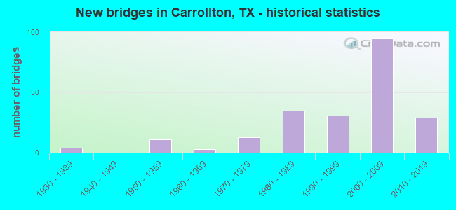
- New bridges - historical statistics
- 41930-1939
- 111950-1959
- 31960-1969
- 131970-1979
- 351980-1989
- 311990-1999
- 952000-2009
- 292010-2019
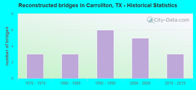
- Reconstructed bridges - Historical Statistics
- 31970-1979
- 31980-1989
- 61990-1999
- 52000-2009
- 32010-2019
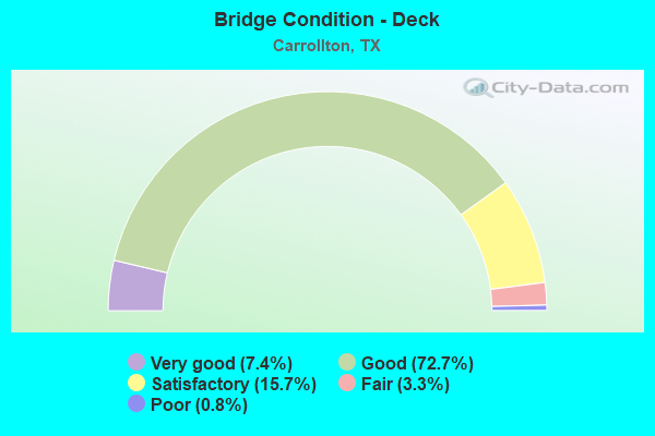
- Bridge Condition - Deck
- 7.4%Very good
- 72.7%Good
- 15.7%Satisfactory
- 3.3%Fair
- 0.8%Poor
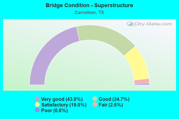
- Bridge Condition - Superstructure
- 43.0%Very good
- 34.7%Good
- 19.0%Satisfactory
- 2.5%Fair
- 0.8%Poor
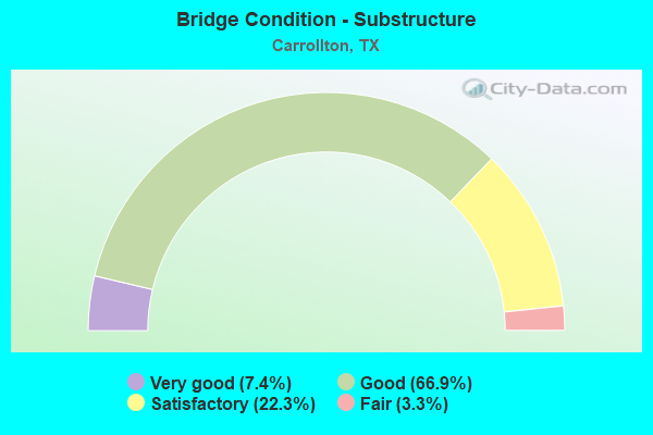
- Bridge Condition - Substructure
- 7.4%Very good
- 66.9%Good
- 22.3%Satisfactory
- 3.3%Fair
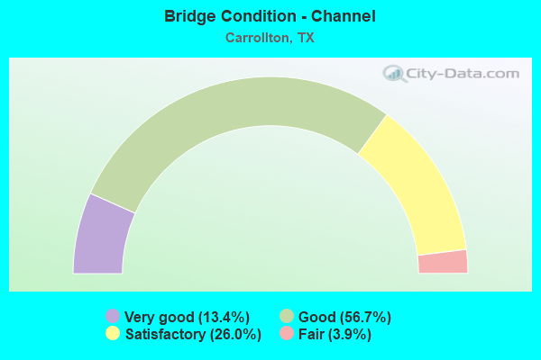
- Bridge Condition - Channel
- 13.4%Very good
- 56.7%Good
- 26.0%Satisfactory
- 3.9%Fair
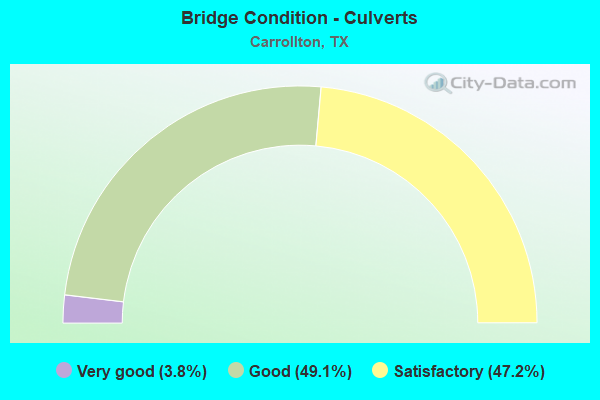
- Bridge Condition - Culverts
- 3.8%Very good
- 49.1%Good
- 47.2%Satisfactory
Find on map >> Show street view
Structure Number: 180610H01840001, Location: 0.60 MI S OF FRANKFORD RD (Lat: 32.990328, Lng: -96.902033), Route carried "on" structure: City street , Year Built: 1982, Status: Open, Structure Length: 4.75m (15.58ft), Average Daily Traffic: 6,067 (year 2013), Truck Traffic: 7%, Average Future Daily Traffic: 7,000 (year 2033), Design Load: HS 20, Features Intersected: FURNEAUX CREEK, Facility Carried by Structure: McCOY RD
Minimum Vertical Clearance: 30+ m (98+ ft), Kilometerpoint: 0.966, Lanes on structure: 2, Owner: City or Municipal Highway Agency, Approaching Roadway Width: 12.2m (40.0ft), Material/Design: Prestressed concrete, Design/Construction: Stringer/Multi-beam, Number Of Spans In Main Unit: 3, Length of Maximum Span: 18.3m (60.0ft), Curb or Sidewalk Widths: Left: 1.7m (5.6ft), Right: 1.7m (5.6ft), Curb-To-Curb Width: 12.2m (40.0ft), Out-to-Out Width: 16.1m (52.8ft)
Condition: Deck: Fair, Superstructure: Good, Substructure: Satisfactory, Channel: Satisfactory, Operating Rating: 54.4 metric tons, Method Used To Determine Operating Rating: Assigned rating based on Load Factor Design (LFD) reported in metric tons, Inventory Rating: 32.7 metric tons, Method Used To Determine Inventory Rating: Assigned rating based on Load Factor Design (LFD) reported in metric tons, Structural Evaluation: Equal to present minimum criteria, Deck Geometry: Somewhat better than minimum adequacy, Waterway Adequacy: Superior to present desirable criteria, Approach Roadway Alignment: Equal to present desirable criteria, Designated Inspection Frequency: Every 24 months, Inspection Date: November 2020, Deck Structure Type: Concrete Cast-file-Place, Wearing Surface/Protective System: Wearing Surface: Bituminous
Find on map >> Show street view
Structure Number: 180610H01855001, Location: 0.25 MI S OF HEBRON PKWY (Lat: 33.021664, Lng: -96.864428), Route carried "on" structure: City street , Year Built: 1986, Status: Open, Structure Length: 1.07m (3.51ft), Average Daily Traffic: 50 (year 2013), Truck Traffic: 4%, Average Future Daily Traffic: 300 (year 2033), Features Intersected: DRAW, Facility Carried by Structure: MEADOW LN
Minimum Vertical Clearance: 30+ m (98+ ft), Kilometerpoint: 0.402, Lanes on structure: 2, Owner: City or Municipal Highway Agency, Approaching Roadway Width: 7.9m (25.9ft), Material/Design: Concrete, Design/Construction: Culvert, Number Of Spans In Main Unit: 4, Length of Maximum Span: 2.4m (7.9ft), Curb-To-Curb Width: 7.9m (25.9ft), Out-to-Out Width: 15.3m (50.2ft)
Condition: Channel: Good, Culverts: Good, Operating Rating: 32.7 metric tons, Method Used To Determine Operating Rating: Field evaluation and documented engineering judgment, Inventory Rating: 24.5 metric tons, Method Used To Determine Inventory Rating: Field evaluation and documented engineering judgment, Structural Evaluation: Equal to present minimum criteria, Deck Geometry: Equal to present minimum criteria, Waterway Adequacy: Better than present minimum criteria, Approach Roadway Alignment: Equal to present desirable criteria, Designated Inspection Frequency: Every 24 months, Inspection Date: November 2020, Deck Structure Type: Concrete Cast-file-Place, Wearing Surface/Protective System: Wearing Surface: Bituminous
Find on map >> Show street view
Structure Number: 180610H02102001, Location: 3.15 MI S OF SH 121 (Lat: 33.006178, Lng: -96.909822), Route carried "on" structure: City street , Year Built: 1985, Status: Open, Structure Length: 6.52m (21.39ft), Average Daily Traffic: 11,500 (year 2013), Truck Traffic: 2%, Average Future Daily Traffic: 21,780 (year 2033), Design Load: HS 20, Features Intersected: DUDLEY BRANCH, Facility Carried by Structure: OLD DENTON RD NB
Minimum Vertical Clearance: 30+ m (98+ ft), Kilometerpoint: 4.624, Lanes on structure: 3, Owner: City or Municipal Highway Agency, Approaching Roadway Width: 10.1m (33.1ft), Skew: 3 degrees, Material/Design: Concrete, Design/Construction: Stringer/Multi-beam, Number Of Spans In Main Unit: 5, Length of Maximum Span: 13.1m (43.0ft), Curb or Sidewalk Widths: Left: 0.0m, Right: 1.2m (3.9ft), Curb-To-Curb Width: 11.3m (37.1ft), Out-to-Out Width: 13.6m (44.6ft)
Condition: Deck: Satisfactory, Superstructure: Satisfactory, Substructure: Satisfactory, Channel: Good, Operating Rating: 54.4 metric tons, Method Used To Determine Operating Rating: Load Factor (LF), Inventory Rating: 32.7 metric tons, Method Used To Determine Inventory Rating: Load Factor (LF), Structural Evaluation: Equal to present minimum criteria, Deck Geometry: High priority of replacement, Waterway Adequacy: Equal to present minimum criteria, Approach Roadway Alignment: Equal to present desirable criteria, Length Of Structure Improvement: 6.49m (21.29ft), Designated Inspection Frequency: Every 24 months, Inspection Date: November 2020, Bridge Improvement Cost: $16,000, Roadway Improvement Cost: $4,000, Total Project Cost: $20,000, Deck Structure Type: Concrete Cast-file-Place
Find on map >> Show street view
Structure Number: 180610H02102002, Location: 3.15 MI S OF SH 121 (Lat: 33.006031, Lng: -96.910011), Route carried "on" structure: City street , Year Built: 1985, Status: Open, Structure Length: 6.52m (21.39ft), Average Daily Traffic: 11,500 (year 2013), Truck Traffic: 2%, Average Future Daily Traffic: 21,780 (year 2033), Design Load: HS 20, Features Intersected: DUDLEY BRANCH, Facility Carried by Structure: OLD DENTON RD SB
Minimum Vertical Clearance: 30+ m (98+ ft), Kilometerpoint: 4.624, Lanes on structure: 3, Owner: City or Municipal Highway Agency, Approaching Roadway Width: 10.1m (33.1ft), Skew: 3 degrees, Material/Design: Concrete, Design/Construction: Stringer/Multi-beam, Number Of Spans In Main Unit: 5, Length of Maximum Span: 13.1m (43.0ft), Curb or Sidewalk Widths: Left: 1.2m (3.9ft), Right: 0.0m, Curb-To-Curb Width: 11.3m (37.1ft), Out-to-Out Width: 13.6m (44.6ft)
Condition: Deck: Satisfactory, Superstructure: Satisfactory, Substructure: Satisfactory, Channel: Good, Operating Rating: 54.4 metric tons, Method Used To Determine Operating Rating: Load Factor (LF), Inventory Rating: 32.7 metric tons, Method Used To Determine Inventory Rating: Load Factor (LF), Structural Evaluation: Equal to present minimum criteria, Deck Geometry: High priority of replacement, Waterway Adequacy: Equal to present minimum criteria, Approach Roadway Alignment: Equal to present desirable criteria, Length Of Structure Improvement: 6.49m (21.29ft), Designated Inspection Frequency: Every 24 months, Inspection Date: November 2020, Bridge Improvement Cost: $16,000, Roadway Improvement Cost: $4,000, Total Project Cost: $20,000, Deck Structure Type: Concrete Cast-file-Place
Find on map >> Show street view
Structure Number: 180610H02102003, Location: 4.35 MI S OF SH 121 (Lat: 32.989764, Lng: -96.909747), Route carried "on" structure: City street , Year Built: 1985, Status: Open, Structure Length: 8.72m (28.61ft), Average Daily Traffic: 13,500 (year 2014), Truck Traffic: 1%, Average Future Daily Traffic: 26,730 (year 2034), Design Load: HS 20, Features Intersected: FURNEAUX CREEK, Facility Carried by Structure: FM 2281 NB
Minimum Vertical Clearance: 30+ m (98+ ft), Kilometerpoint: 6.497, Lanes on structure: 3, Owner: City or Municipal Highway Agency, Approaching Roadway Width: 11.6m (38.1ft), Skew: 1 degrees, Material/Design: Concrete, Design/Construction: Stringer/Multi-beam, Number Of Spans In Main Unit: 7, Length of Maximum Span: 12.5m (41.0ft), Curb or Sidewalk Widths: Left: 0.0m, Right: 1.2m (3.9ft), Curb-To-Curb Width: 11.4m (37.4ft), Out-to-Out Width: 13.6m (44.6ft)
Condition: Deck: Good, Superstructure: Good, Substructure: Satisfactory, Channel: Satisfactory, Operating Rating: 54.4 metric tons, Method Used To Determine Operating Rating: Load Factor (LF), Inventory Rating: 32.7 metric tons, Method Used To Determine Inventory Rating: Load Factor (LF), Structural Evaluation: Equal to present minimum criteria, Deck Geometry: High priority of replacement, Waterway Adequacy: Equal to present minimum criteria, Approach Roadway Alignment: Equal to present desirable criteria, Length Of Structure Improvement: 8.69m (28.51ft), Designated Inspection Frequency: Every 24 months, Inspection Date: Febuary 2021, Bridge Improvement Cost: $22,000, Roadway Improvement Cost: $6,000, Total Project Cost: $28,000, Deck Structure Type: Concrete Cast-file-Place
Find on map >> Show street view
Structure Number: 180610H02102004, Location: 4.35 MI S OF SH 121 (Lat: 32.989722, Lng: -96.909944), Route carried "on" structure: City street , Year Built: 1985, Year Reconstructed: 2016, Status: Open, Structure Length: 8.72m (28.61ft), Average Daily Traffic: 13,500 (year 2014), Truck Traffic: 1%, Average Future Daily Traffic: 26,730 (year 2034), Design Load: HS 20, Features Intersected: FURNEAUX CREEK, Facility Carried by Structure: FM 2281 SB
Minimum Vertical Clearance: 30+ m (98+ ft), Kilometerpoint: 6.497, Lanes on structure: 3, Owner: City or Municipal Highway Agency, Approaching Roadway Width: 11.6m (38.1ft), Skew: 1 degrees, Material/Design: Concrete, Design/Construction: Stringer/Multi-beam, Number Of Spans In Main Unit: 7, Length of Maximum Span: 12.5m (41.0ft), Curb or Sidewalk Widths: Left: 3.0m (9.8ft), Right: 0.0m, Curb-To-Curb Width: 11.4m (37.4ft), Out-to-Out Width: 15.5m (50.9ft)
Condition: Deck: Good, Superstructure: Good, Substructure: Good, Channel: Satisfactory, Operating Rating: 54.4 metric tons, Method Used To Determine Operating Rating: Load Factor (LF), Inventory Rating: 32.7 metric tons, Method Used To Determine Inventory Rating: Load Factor (LF), Structural Evaluation: Better than present minimum criteria, Deck Geometry: High priority of replacement, Waterway Adequacy: Equal to present minimum criteria, Approach Roadway Alignment: Equal to present desirable criteria, Length Of Structure Improvement: 8.69m (28.51ft), Designated Inspection Frequency: Every 24 months, Inspection Date: Febuary 2021, Bridge Improvement Cost: $22,000, Roadway Improvement Cost: $6,000, Total Project Cost: $28,000, Deck Structure Type: Concrete Cast-file-Place
Find on map >> Show street view
Structure Number: 180610H02210001, Location: 0.25 MI E OF JOSEY LN (Lat: 33.006822, Lng: -96.882139), Route carried "on" structure: City street , Year Built: 1973, Status: Open, Structure Length: 2.44m (8.01ft), Average Daily Traffic: 4,770 (year 2013), Truck Traffic: 5%, Average Future Daily Traffic: 8,741 (year 2033), Design Load: HS 20, Features Intersected: FURNEAUX CREEK, Facility Carried by Structure: PETERS COLONY RD
Minimum Vertical Clearance: 30+ m (98+ ft), Kilometerpoint: 1.996, Lanes on structure: 2, Owner: City or Municipal Highway Agency, Approaching Roadway Width: 11.0m (36.1ft), Material/Design: Concrete, Design/Construction: Stringer/Multi-beam, Number Of Spans In Main Unit: 2, Length of Maximum Span: 12.2m (40.0ft), Curb or Sidewalk Widths: Left: 1.5m (4.9ft), Right: 1.5m (4.9ft), Curb-To-Curb Width: 11.0m (36.1ft), Out-to-Out Width: 14.6m (47.9ft)
Condition: Deck: Good, Superstructure: Good, Substructure: Good, Channel: Good, Operating Rating: 53.5 metric tons, Method Used To Determine Operating Rating: Load Factor (LF), Inventory Rating: 31.7 metric tons, Method Used To Determine Inventory Rating: Load Factor (LF), Structural Evaluation: Better than present minimum criteria, Deck Geometry: Somewhat better than minimum adequacy, Waterway Adequacy: Better than present minimum criteria, Approach Roadway Alignment: Equal to present desirable criteria, Designated Inspection Frequency: Every 24 months, Inspection Date: November 2020, Deck Structure Type: Concrete Cast-file-Place
Find on map >> Show street view
Structure Number: 180610H02257001, Location: 0.30 MI S OF HEBRON PKWY (Lat: 33.020408, Lng: -96.869736), Route carried "on" structure: City street , Year Built: 1984, Status: Open, Structure Length: 1.62m (5.31ft), Average Daily Traffic: 9,050 (year 2013), Average Future Daily Traffic: 14,028 (year 2033), Design Load: HS 20, Features Intersected: FURNEAUX CREEK TRIBUTARY, Facility Carried by Structure: PROVINCE DR
Minimum Vertical Clearance: 30+ m (98+ ft), Kilometerpoint: 0.483, Lanes on structure: 2, Owner: City or Municipal Highway Agency, Approaching Roadway Width: 12.2m (40.0ft), Material/Design: Concrete, Design/Construction: Culvert, Number Of Spans In Main Unit: 6, Length of Maximum Span: 2.4m (7.9ft), Curb or Sidewalk Widths: Left: 3.0m (9.8ft), Right: 2.7m (8.9ft), Curb-To-Curb Width: 18.0m (59.1ft), Out-to-Out Width: 18.4m (60.4ft)
Condition: Channel: Good, Culverts: Satisfactory, Operating Rating: 39.9 metric tons, Method Used To Determine Operating Rating: Load Factor (LF), Inventory Rating: 23.6 metric tons, Method Used To Determine Inventory Rating: Load Factor (LF), Structural Evaluation: Somewhat better than minimum adequacy, Deck Geometry: Superior to present desirable criteria, Waterway Adequacy: Better than present minimum criteria, Approach Roadway Alignment: Equal to present desirable criteria, Designated Inspection Frequency: Every 24 months, Inspection Date: November 2020, Deck Structure Type: Concrete Cast-file-Place, Wearing Surface/Protective System: Wearing Surface: Monolithic Concrete
Find on map >> Show street view
Structure Number: 180610H02450001, Location: 0.20 MI N OF FRANKFORD RD (Lat: 33.000119, Lng: -96.919817), Route carried "on" structure: City street , Year Built: 1986, Status: Open, Structure Length: 2.29m (7.51ft), Average Daily Traffic: 2,060 (year 2013), Average Future Daily Traffic: 3,392 (year 2033), Features Intersected: DUDLEY BRANCH, Facility Carried by Structure: ROSEMEADE PKWY
Minimum Vertical Clearance: 30+ m (98+ ft), Kilometerpoint: 0.322, Lanes on structure: 5, Owner: City or Municipal Highway Agency, Approaching Roadway Width: 14.6m (47.9ft), Skew: 20 degrees, Material/Design: Concrete, Design/Construction: Culvert, Number Of Spans In Main Unit: 7, Length of Maximum Span: 3.0m (9.8ft), Curb or Sidewalk Widths: Left: 1.4m (4.6ft), Right: 2.3m (7.5ft)
Condition: Channel: Satisfactory, Culverts: Satisfactory, Operating Rating: 32.7 metric tons, Method Used To Determine Operating Rating: Field evaluation and documented engineering judgment, Inventory Rating: 24.5 metric tons, Method Used To Determine Inventory Rating: Field evaluation and documented engineering judgment, Structural Evaluation: Equal to present minimum criteria, Waterway Adequacy: Superior to present desirable criteria, Approach Roadway Alignment: Equal to present desirable criteria, Designated Inspection Frequency: Every 24 months, Inspection Date: November 2020
Find on map >> Show street view
Structure Number: 180610H02450018, Location: 0.50 MI E OF JOSEY LN (Lat: 33.011650, Lng: -96.879325), Route carried "on" structure: City street , Year Built: 1985, Status: Open, Structure Length: 3.26m (10.70ft), Average Daily Traffic: 5,150 (year 2013), Average Future Daily Traffic: 8,480 (year 2033), Design Load: HS 20, Features Intersected: FURNEAUX CREEK, Facility Carried by Structure: ROSEMEADE PKWY
Minimum Vertical Clearance: 30+ m (98+ ft), Kilometerpoint: 2.575, Lanes on structure: 4, Owner: City or Municipal Highway Agency, Approaching Roadway Width: 14.6m (47.9ft), Skew: 20 degrees, Material/Design: Concrete, Design/Construction: Culvert, Number Of Spans In Main Unit: 10, Length of Maximum Span: 3.0m (9.8ft), Curb or Sidewalk Widths: Left: 1.5m (4.9ft), Right: 1.5m (4.9ft), Curb-To-Curb Width: 14.6m (47.9ft), Out-to-Out Width: 27.9m (91.5ft)
Condition: Channel: Good, Culverts: Satisfactory, Operating Rating: 39.9 metric tons, Method Used To Determine Operating Rating: Load Factor (LF), Inventory Rating: 23.6 metric tons, Method Used To Determine Inventory Rating: Load Factor (LF), Structural Evaluation: Somewhat better than minimum adequacy, Deck Geometry: High priority of replacement, Waterway Adequacy: Equal to present minimum criteria, Approach Roadway Alignment: Equal to present desirable criteria, Length Of Structure Improvement: 3.26m (10.70ft), Designated Inspection Frequency: Every 24 months, Inspection Date: November 2020, Bridge Improvement Cost: $10,000, Roadway Improvement Cost: $3,000, Total Project Cost: $13,000, Deck Structure Type: Concrete Cast-file-Place, Wearing Surface/Protective System: Wearing Surface: Monolithic Concrete
Find on map >> Show street view
Structure Number: 180610H02760001, Location: 0.01 MI S ROSEMEADE PKWY (Lat: 33.009925, Lng: -96.898414), Route carried "on" structure: City street , Year Built: 1978, Status: Open, Structure Length: 1.07m (3.51ft), Average Daily Traffic: 2,627 (year 2013), Average Future Daily Traffic: 4,814 (year 2033), Design Load: HS 20, Features Intersected: DUDLEY BRANCH TRIBUTARY, Facility Carried by Structure: STANDRIDGE DR
Minimum Vertical Clearance: 30+ m (98+ ft), Kilometerpoint: 0.563, Lanes on structure: 3, Owner: City or Municipal Highway Agency, Approaching Roadway Width: 12.2m (40.0ft), Material/Design: Concrete, Design/Construction: Culvert, Number Of Spans In Main Unit: 4, Length of Maximum Span: 2.4m (7.9ft), Curb or Sidewalk Widths: Left: 1.5m (4.9ft), Right: 1.5m (4.9ft), Curb-To-Curb Width: 12.2m (40.0ft), Out-to-Out Width: 19.5m (64.0ft)
Condition: Channel: Good, Culverts: Good, Operating Rating: 39.9 metric tons, Method Used To Determine Operating Rating: Load Factor (LF), Inventory Rating: 23.6 metric tons, Method Used To Determine Inventory Rating: Load Factor (LF), Structural Evaluation: Equal to present minimum criteria, Deck Geometry: Meets minimum limits, Waterway Adequacy: Equal to present minimum criteria, Approach Roadway Alignment: Equal to present desirable criteria, Designated Inspection Frequency: Every 24 months, Inspection Date: November 2020, Deck Structure Type: Concrete Cast-file-Place, Wearing Surface/Protective System: Wearing Surface: Monolithic Concrete
Find on map >> Show street view
Structure Number: 180570019603019, Location: 2.1 Mi SE of SH 121 (Lat: 32.979208, Lng: -96.933386), Route carried "under" structure: Other road 35, Year Built: 2004, Structure Length: 0. m, Average Daily Traffic: 10,000 (year 2016), Features Intersected: IH 35E etc, Facility Carried by Structure: PGBT EB
Minimum Vertical Clearance: 7.83m (25.69ft), Kilometerpoint: 0.002, Lanes on structure: 3, Lanes under structure: 25, Toll: On toll road, Material/Design: Steel, Design/Construction: Stringer/Multi-beam, Length of Maximum Span: 52.1m (170.9ft)
Find on map >> Show street view
Structure Number: 180570019603068, Location: 2.8 Mi NW of IH 635 (Lat: 32.946978, Lng: -96.905764), Route carried "under" structure: Business State highway 310, Year Built: 1957, Structure Length: 0. m, Average Daily Traffic: 10,400 (year 2013), Truck Traffic: 4%, Features Intersected: Crosby Rd (LP 310), Facility Carried by Structure: IH 35E NB
Minimum Vertical Clearance: 4.47m (14.67ft), Kilometerpoint: 18.950, Lanes on structure: 5, Lanes under structure: 4, Material/Design: Steel continuous, Design/Construction: Stringer/Multi-beam, Length of Maximum Span: 19.2m (63.0ft)
Find on map >> Show street view
Structure Number: 180570019603069, Location: 2.8 Mi NW of IH 635 (Lat: 32.947036, Lng: -96.906350), Route carried "under" structure: Business State highway 310, Year Built: 1957, Structure Length: 0. m, Average Daily Traffic: 10,400 (year 2013), Truck Traffic: 4%, Features Intersected: Crosby Rd (LP 310), Facility Carried by Structure: IH 35E SB
Minimum Vertical Clearance: 4.72m (15.49ft), Kilometerpoint: 18.998, Lanes on structure: 4, Lanes under structure: 4, Material/Design: Steel continuous, Design/Construction: Stringer/Multi-beam, Length of Maximum Span: 19.2m (63.0ft)
Find on map >> Show street view
Structure Number: 180570019603095, Location: 4.2 Mi NW of IH 635 (Lat: 32.963947, Lng: -96.917836), Route carried "under" structure: Interstate 35, Year Built: 2001, Structure Length: 0. m, Average Daily Traffic: 174,000 (year 2013), Truck Traffic: 7%, Features Intersected: IH 35E, Facility Carried by Structure: Luna Rd
Minimum Vertical Clearance: 7.09m (23.26ft), Kilometerpoint: 51.909, Lanes on structure: 6, Lanes under structure: 13, Material/Design: Steel continuous, Design/Construction: Stringer/Multi-beam, Length of Maximum Span: 45.4m (149.0ft)
Find on map >> Show street view
Structure Number: 180570019603107, Location: 2.1 Mi SE of SH 121 (Lat: 32.979283, Lng: -96.933678), Route carried "under" structure: Other road 35, Year Built: 2004, Structure Length: 0. m, Average Daily Traffic: 50,000 (year 2016), Features Intersected: IH 35E etc, Facility Carried by Structure: PGBT WB
Minimum Vertical Clearance: 7.24m (23.75ft), Kilometerpoint: 7.607, Lanes on structure: 3, Lanes under structure: 25, Toll: On toll road, Material/Design: Prestressed concrete, Design/Construction: Stringer/Multi-beam, Length of Maximum Span: 38.4m (126.0ft)
Find on map >> Show street view
Structure Number: 180570019603452, Location: IH 35E/SH 190 Interchange (Lat: 32.979942, Lng: -96.927803), Route carried "under" structure: ServiceState highway 190, Year Built: 2001, Structure Length: 0. m, Average Daily Traffic: 2,000 (year 2011), Features Intersected: IH35E NBFR&Trinity Mills, Facility Carried by Structure: IH35E NB/PGBT EB
Minimum Vertical Clearance: 6.12m (20.08ft), Kilometerpoint: 1.609, Lanes on structure: 2, Lanes under structure: 6, Material/Design: Steel continuous, Design/Construction: Stringer/Multi-beam, Length of Maximum Span: 53.3m (174.9ft)
Find on map >> Show street view
Structure Number: 180570019603453, Location: IH 35E/SH 190 Interchange (Lat: 32.980475, Lng: -96.928386), Route carried "under" structure: Interstate 190, Year Built: 2004, Structure Length: 0. m, Average Daily Traffic: 10,000 (year 2011), Truck Traffic: 2%, Features Intersected: SH 190 ML, Facility Carried by Structure: IH35E NB/PGBT WB
Minimum Vertical Clearance: 6.76m (22.18ft), Kilometerpoint: 0.002, Lanes on structure: 1, Lanes under structure: 17, Toll: On toll road, Material/Design: Steel continuous, Design/Construction: Stringer/Multi-beam, Length of Maximum Span: 76.2m (250.0ft)
Find on map >> Show street view
Structure Number: 180570019603454, Location: IH 35E/SH 190 Interchange (Lat: 32.983389, Lng: -96.932328), Route carried "under" structure: Interstate 190, Year Built: 2001, Structure Length: 0. m, Average Daily Traffic: 10,000 (year 2011), Truck Traffic: 2%, Features Intersected: SH 190 ML & Connectors, Facility Carried by Structure: IH35E SB/PGBT EB
Minimum Vertical Clearance: 6.12m (20.08ft), Kilometerpoint: 0.002, Lanes on structure: 2, Lanes under structure: 20, Toll: On toll road, Material/Design: Steel continuous, Design/Construction: Stringer/Multi-beam, Length of Maximum Span: 76.2m (250.0ft)
Find on map >> Show street view
Structure Number: 180570019603455, Location: IH 35E/SH 190 Interchange (Lat: 32.978939, Lng: -96.933928), Route carried "under" structure: ServiceInterstate 35, Year Built: 2004, Structure Length: 0. m, Average Daily Traffic: 5,000 (year 2011), Truck Traffic: 2%, Features Intersected: IH 35E SBFR
Minimum Vertical Clearance: 5.28m (17.32ft), Kilometerpoint: 0.002, Lanes on structure: 2, Lanes under structure: 2, Material/Design: Prestressed concrete, Design/Construction: Stringer/Multi-beam, Length of Maximum Span: 38.1m (125.0ft)
Find on map >> Show street view
Structure Number: 180570019603456, Location: IH 35E/SH 190 Connectors (Lat: 32.983719, Lng: -96.926869), Route carried "under" structure: Interstate 35, Year Built: 2001, Structure Length: 0. m, Average Daily Traffic: 10,000 (year 2011), Truck Traffic: 2%, Features Intersected: IH35E & SH190 Conns.
Minimum Vertical Clearance: 5.41m (17.75ft), Kilometerpoint: 0.002, Lanes on structure: 2, Lanes under structure: 21, Toll: On toll road, Material/Design: Steel continuous, Design/Construction: Stringer/Multi-beam, Length of Maximum Span: 71.0m (232.9ft)
Find on map >> Show street view
Structure Number: 180570019603457, Location: IH 35E/SH 190 Interchange (Lat: 32.983261, Lng: -96.929589), Route carried "under" structure: Ramp Interstate 35, Year Built: 2001, Structure Length: 0. m, Average Daily Traffic: 8,000 (year 2011), Truck Traffic: 2%, Features Intersected: IH35E NBFR&Trinity Mills
Minimum Vertical Clearance: 5.41m (17.75ft), Kilometerpoint: 0.002, Lanes on structure: 2, Lanes under structure: 5, Material/Design: Steel continuous, Design/Construction: Stringer/Multi-beam, Length of Maximum Span: 57.9m (190.0ft)
Find on map >> Show street view
Structure Number: 180570019603458, Location: IH 35E/SH 190 Interchange (Lat: 32.978211, Lng: -96.933303), Route carried "under" structure: Interstate 190, Year Built: 2004, Structure Length: 0. m, Average Daily Traffic: 5,000 (year 2011), Truck Traffic: 2%, Features Intersected: IH 35E & SH 190 Conns, Facility Carried by Structure: PGBT EB/IH35E NB
Minimum Vertical Clearance: 5.01m (16.44ft), Kilometerpoint: 0.002, Lanes on structure: 2, Lanes under structure: 20, Toll: On toll road, Material/Design: Steel continuous, Design/Construction: Stringer/Multi-beam, Length of Maximum Span: 69.2m (227.0ft)
Find on map >> Show street view
Structure Number: 180570019603459, Location: IH 35E/SH 190 Interchange (Lat: 32.979550, Lng: -96.932697), Route carried "under" structure: ServiceInterstate 35, Year Built: 2004, Structure Length: 0. m, Average Daily Traffic: 8,000 (year 2011), Truck Traffic: 1%, Features Intersected: IH 35E SBFR
Minimum Vertical Clearance: 15.04m (49.34ft), Kilometerpoint: 0.002, Lanes on structure: 1, Lanes under structure: 2, Material/Design: Steel continuous, Design/Construction: Stringer/Multi-beam, Length of Maximum Span: 53.6m (175.9ft)
Find on map >> Show street view
Structure Number: 180570019603467, Location: 4.5 Mi NW of IH 635 (Lat: 32.968397, Lng: -96.919742), Route carried "under" structure: Business City street 310, Year Built: 1957, Structure Length: 0. m, Average Daily Traffic: 19,600 (year 2013), Truck Traffic: 3%, Features Intersected: Whitlock Lane, Facility Carried by Structure: IH 35 E
Minimum Vertical Clearance: 4.80m (15.75ft), Kilometerpoint: 16.053, Lanes on structure: 8, Lanes under structure: 5, Material/Design: Steel continuous, Design/Construction: Stringer/Multi-beam, Length of Maximum Span: 13.7m (44.9ft)
Find on map >> Show street view
Structure Number: 180570019603483, Location: 2.5 MI S. of GWB/I35E JCT (Lat: 32.951864, Lng: -96.910264), Route carried "under" structure: ServiceCity street , Year Built: 2018, Structure Length: 0. m, Average Daily Traffic: 15,000 (year 2018), Truck Traffic: 10%, Features Intersected: IH 35E SB FR, Facility Carried by Structure: IH 35E SB FR
Minimum Vertical Clearance: 8.81m (28.90ft), Kilometerpoint: 0.000, Lanes on structure: 2, Lanes under structure: 4, Material/Design: Prestressed concrete, Design/Construction: Stringer/Multi-beam, Length of Maximum Span: 39.6m (129.9ft)
Find on map >> Show street view
Structure Number: 180570019603484, Location: 2.5 MI S. of GWB/I35E JCT (Lat: 32.952322, Lng: -96.909294), Route carried "under" structure: ServiceCity street , Year Built: 2018, Structure Length: 0. m, Average Daily Traffic: 15,000 (year 2018), Truck Traffic: 10%, Features Intersected: IH 35E NB FR, Facility Carried by Structure: IH 35E NB FR
Minimum Vertical Clearance: 6.55m (21.49ft), Kilometerpoint: 0.000, Lanes on structure: 3, Lanes under structure: 4, Material/Design: Prestressed concrete, Design/Construction: Stringer/Multi-beam, Length of Maximum Span: 48.5m (159.1ft)
Find on map >> Show street view
Structure Number: 180570019603485, Location: 2.5 MI S. of GWB/I35E JCT (Lat: 32.953997, Lng: -96.910472), Route carried "under" structure: City street , Year Built: 2018, Structure Length: 0. m, Average Daily Traffic: 15,000 (year 2018), Truck Traffic: 10%, Features Intersected: IH 35E NB FR, Facility Carried by Structure: IH 35E NB FR
Minimum Vertical Clearance: 7.04m (23.10ft), Kilometerpoint: 0.000, Lanes on structure: 2, Lanes under structure: 2, Material/Design: Prestressed concrete, Design/Construction: Stringer/Multi-beam, Length of Maximum Span: 40.8m (133.9ft)
Find on map >> Show street view
Structure Number: 180570019603486, Location: 2.5 MI S. of GWB/I35E JCT (Lat: 32.953656, Lng: -96.911483), Route carried "under" structure: ServiceCity street , Year Built: 2018, Structure Length: 0. m, Average Daily Traffic: 15,000 (year 2018), Truck Traffic: 10%, Features Intersected: IH 35E SB FR, Facility Carried by Structure: IH 35E SB FR
Minimum Vertical Clearance: 8.02m (26.31ft), Kilometerpoint: 0.000, Lanes on structure: 6, Lanes under structure: 2, Material/Design: Prestressed concrete, Design/Construction: Stringer/Multi-beam, Length of Maximum Span: 40.5m (132.9ft)
Find on map >> Show street view
Structure Number: 1805700196035, Location: 3.0 MI NW OF IH 635 (Lat: 32.949767, Lng: -96.908158), Route carried "under" structure: State highway , Year Built: 2018, Structure Length: 0. m, Average Daily Traffic: 11,500 (year 2017), Truck Traffic: 2%, Features Intersected: W BELT LINE BNSF RR etc, Facility Carried by Structure: IH 35E
Minimum Vertical Clearance: 5.85m (19.19ft), Kilometerpoint: 0.000, Lanes on structure: 8, Lanes under structure: 15, Material/Design: Steel, Design/Construction: Stringer/Multi-beam, Length of Maximum Span: 73.2m (240.2ft)
Structure Number: 180570296402588, Location: 3.0 Mi N of IH 635, Route carried "under" structure: City street , Year Built: 2006, Structure Length: 0. m, Average Daily Traffic: 10,000 (year 2011), Truck Traffic: 2%, Features Intersected: Belt Line Rd & Hutton Br, Facility Carried by Structure: PGBT SB
Minimum Vertical Clearance: 9.68m (31.76ft), Kilometerpoint: 3.851, Lanes on structure: 3, Lanes under structure: 9, Material/Design: Prestressed concrete, Design/Construction: Stringer/Multi-beam, Length of Maximum Span: 38.7m (127.0ft)
Minimum Vertical Clearance: 9.68m (31.76ft), Kilometerpoint: 3.851, Lanes on structure: 3, Lanes under structure: 9, Material/Design: Prestressed concrete, Design/Construction: Stringer/Multi-beam, Length of Maximum Span: 38.7m (127.0ft)
Structure Number: 180570296402589, Location: 3.0 Mi N of IH 635, Route carried "under" structure: City street , Year Built: 2006, Structure Length: 0. m, Average Daily Traffic: 10,000 (year 2011), Truck Traffic: 2%, Features Intersected: Belt Line Rd & Hutton Br, Facility Carried by Structure: PGBT NB
Minimum Vertical Clearance: 9.53m (31.27ft), Kilometerpoint: 4.028, Lanes on structure: 3, Lanes under structure: 9, Material/Design: Prestressed concrete, Design/Construction: Stringer/Multi-beam, Length of Maximum Span: 39.3m (128.9ft)
Minimum Vertical Clearance: 9.53m (31.27ft), Kilometerpoint: 4.028, Lanes on structure: 3, Lanes under structure: 9, Material/Design: Prestressed concrete, Design/Construction: Stringer/Multi-beam, Length of Maximum Span: 39.3m (128.9ft)
Structure Number: 180570296402592, Location: 1.0 Mi S of IH 35E, Route carried "under" structure: City street , Year Built: 2006, Structure Length: 0. m, Average Daily Traffic: 10,000 (year 2011), Truck Traffic: 2%, Features Intersected: Sandy Lake Rd, Facility Carried by Structure: PGBT NB
Minimum Vertical Clearance: 5.11m (16.77ft), Kilometerpoint: 32.882, Lanes on structure: 3, Lanes under structure: 9, Material/Design: Prestressed concrete, Design/Construction: Stringer/Multi-beam, Length of Maximum Span: 38.4m (126.0ft)
Minimum Vertical Clearance: 5.11m (16.77ft), Kilometerpoint: 32.882, Lanes on structure: 3, Lanes under structure: 9, Material/Design: Prestressed concrete, Design/Construction: Stringer/Multi-beam, Length of Maximum Span: 38.4m (126.0ft)
Structure Number: 180570296402593, Location: 1.0 Mi S of IH 35E, Route carried "under" structure: City street , Year Built: 2006, Structure Length: 0. m, Average Daily Traffic: 10,000 (year 2011), Truck Traffic: 2%, Features Intersected: Sandy Lake Rd, Facility Carried by Structure: PGBT SB
Minimum Vertical Clearance: 5.36m (17.59ft), Kilometerpoint: 67.592, Lanes on structure: 3, Lanes under structure: 9, Material/Design: Prestressed concrete, Design/Construction: Stringer/Multi-beam, Length of Maximum Span: 38.4m (126.0ft)
Minimum Vertical Clearance: 5.36m (17.59ft), Kilometerpoint: 67.592, Lanes on structure: 3, Lanes under structure: 9, Material/Design: Prestressed concrete, Design/Construction: Stringer/Multi-beam, Length of Maximum Span: 38.4m (126.0ft)
Structure Number: 180570296402594, Location: 0.8 Mi S of IH 35E, Route carried "under" structure: City street , Year Built: 2006, Structure Length: 0. m, Average Daily Traffic: 50 (year 2011), Features Intersected: DWU Access Rd, Facility Carried by Structure: PGBT NBFR
Minimum Vertical Clearance: 5.23m (17.16ft), Kilometerpoint: 18.559, Lanes on structure: 2, Lanes under structure: 1, Material/Design: Prestressed concrete, Design/Construction: Stringer/Multi-beam, Length of Maximum Span: 34.1m (111.9ft)
Minimum Vertical Clearance: 5.23m (17.16ft), Kilometerpoint: 18.559, Lanes on structure: 2, Lanes under structure: 1, Material/Design: Prestressed concrete, Design/Construction: Stringer/Multi-beam, Length of Maximum Span: 34.1m (111.9ft)
Structure Number: 180570296402595, Location: 0.8 Mi S of IH 35E, Route carried "under" structure: City street , Year Built: 2006, Structure Length: 0. m, Average Daily Traffic: 50 (year 2011), Features Intersected: DWU Access Rd, Facility Carried by Structure: PGBT NB On-Ramp
Minimum Vertical Clearance: 6.07m (19.91ft), Kilometerpoint: 18.633, Lanes on structure: 1, Lanes under structure: 1, Material/Design: Prestressed concrete, Design/Construction: Stringer/Multi-beam, Length of Maximum Span: 34.1m (111.9ft)
Minimum Vertical Clearance: 6.07m (19.91ft), Kilometerpoint: 18.633, Lanes on structure: 1, Lanes under structure: 1, Material/Design: Prestressed concrete, Design/Construction: Stringer/Multi-beam, Length of Maximum Span: 34.1m (111.9ft)
Structure Number: 180570296402596, Location: 0.8 Mi S of IH 35E, Route carried "under" structure: City street , Year Built: 2006, Structure Length: 0. m, Average Daily Traffic: 50 (year 2011), Features Intersected: DWU Access Rd, Facility Carried by Structure: PGBT NBML
Minimum Vertical Clearance: 5.94m (19.49ft), Kilometerpoint: 20.122, Lanes on structure: 3, Lanes under structure: 1, Material/Design: Prestressed concrete, Design/Construction: Stringer/Multi-beam, Length of Maximum Span: 34.1m (111.9ft)
Minimum Vertical Clearance: 5.94m (19.49ft), Kilometerpoint: 20.122, Lanes on structure: 3, Lanes under structure: 1, Material/Design: Prestressed concrete, Design/Construction: Stringer/Multi-beam, Length of Maximum Span: 34.1m (111.9ft)
Structure Number: 180570296402598, Location: 0.8 Mi S of IH 35E, Route carried "under" structure: City street , Year Built: 2006, Structure Length: 0. m, Average Daily Traffic: 50 (year 2011), Features Intersected: DWU Access Rd, Facility Carried by Structure: PGBT SBML
Minimum Vertical Clearance: 5.72m (18.77ft), Kilometerpoint: 21.778, Lanes on structure: 4, Lanes under structure: 1, Material/Design: Prestressed concrete, Design/Construction: Stringer/Multi-beam, Length of Maximum Span: 34.1m (111.9ft)
Minimum Vertical Clearance: 5.72m (18.77ft), Kilometerpoint: 21.778, Lanes on structure: 4, Lanes under structure: 1, Material/Design: Prestressed concrete, Design/Construction: Stringer/Multi-beam, Length of Maximum Span: 34.1m (111.9ft)
Structure Number: 180570296402599, Location: 0.8 Mi S of IH 35E, Route carried "under" structure: City street , Year Built: 2006, Structure Length: 0. m, Average Daily Traffic: 50 (year 2011), Features Intersected: DWU Access Rd, Facility Carried by Structure: PGBT SB Off-Ramp
Minimum Vertical Clearance: 4.93m (16.17ft), Kilometerpoint: 20.973, Lanes on structure: 1, Lanes under structure: 1, Material/Design: Prestressed concrete, Design/Construction: Stringer/Multi-beam, Length of Maximum Span: 34.1m (111.9ft)
Minimum Vertical Clearance: 4.93m (16.17ft), Kilometerpoint: 20.973, Lanes on structure: 1, Lanes under structure: 1, Material/Design: Prestressed concrete, Design/Construction: Stringer/Multi-beam, Length of Maximum Span: 34.1m (111.9ft)
Structure Number: 18057029640361, Location: 1.2 Mi E of IH 35E, Route carried "under" structure: Other road 190, Year Built: 2001, Structure Length: 0. m, Average Daily Traffic: 10,000 (year 2011), Features Intersected: SH 190, Facility Carried by Structure: Old Denton Rd NB
Minimum Vertical Clearance: 5.77m (18.93ft), Kilometerpoint: 22.598, Lanes on structure: 5, Lanes under structure: 8, Toll: On toll road, Material/Design: Prestressed concrete, Design/Construction: Stringer/Multi-beam, Length of Maximum Span: 25.6m (84.0ft)
Minimum Vertical Clearance: 5.77m (18.93ft), Kilometerpoint: 22.598, Lanes on structure: 5, Lanes under structure: 8, Toll: On toll road, Material/Design: Prestressed concrete, Design/Construction: Stringer/Multi-beam, Length of Maximum Span: 25.6m (84.0ft)
Structure Number: 180570296403611, Location: 1.9 Mi E of IH 35E, Route carried "under" structure: Other road 190, Year Built: 2001, Structure Length: 0. m, Average Daily Traffic: 10,000 (year 2011), Features Intersected: SH 190, Facility Carried by Structure: McCoy Rd
Minimum Vertical Clearance: 7.04m (23.10ft), Kilometerpoint: 28.202, Lanes on structure: 4, Lanes under structure: 8, Toll: On toll road, Material/Design: Prestressed concrete, Design/Construction: Stringer/Multi-beam, Length of Maximum Span: 38.4m (126.0ft)
Minimum Vertical Clearance: 7.04m (23.10ft), Kilometerpoint: 28.202, Lanes on structure: 4, Lanes under structure: 8, Toll: On toll road, Material/Design: Prestressed concrete, Design/Construction: Stringer/Multi-beam, Length of Maximum Span: 38.4m (126.0ft)
Structure Number: 180570296403612, Location: 1.1 Mi E of Old Denton Rd, Route carried "under" structure: Other road 190, Year Built: 2001, Structure Length: 0. m, Average Daily Traffic: 10,000 (year 2011), Features Intersected: SH 190, Facility Carried by Structure: Josey Ln NB
Minimum Vertical Clearance: 7.16m (23.49ft), Kilometerpoint: 15.244, Lanes on structure: 5, Lanes under structure: 8, Toll: On toll road, Material/Design: Prestressed concrete, Design/Construction: Stringer/Multi-beam, Length of Maximum Span: 26.5m (86.9ft)
Minimum Vertical Clearance: 7.16m (23.49ft), Kilometerpoint: 15.244, Lanes on structure: 5, Lanes under structure: 8, Toll: On toll road, Material/Design: Prestressed concrete, Design/Construction: Stringer/Multi-beam, Length of Maximum Span: 26.5m (86.9ft)
Structure Number: 180570296403613, Location: 0.4 Mi E of Josey Ln, Route carried "under" structure: Other road 190, Year Built: 2001, Structure Length: 0. m, Average Daily Traffic: 10,000 (year 2011), Features Intersected: SH 190, Facility Carried by Structure: Scott Mill Rd
Minimum Vertical Clearance: 5.51m (18.08ft), Kilometerpoint: 16.779, Lanes on structure: 4, Lanes under structure: 10, Toll: On toll road, Material/Design: Prestressed concrete, Design/Construction: Stringer/Multi-beam, Length of Maximum Span: 36.3m (119.1ft)
Minimum Vertical Clearance: 5.51m (18.08ft), Kilometerpoint: 16.779, Lanes on structure: 4, Lanes under structure: 10, Toll: On toll road, Material/Design: Prestressed concrete, Design/Construction: Stringer/Multi-beam, Length of Maximum Span: 36.3m (119.1ft)
Structure Number: 180570296403614, Location: 1.3 Mi E of Josey Ln, Route carried "under" structure: Other road 190, Year Built: 2001, Structure Length: 0. m, Average Daily Traffic: 10,000 (year 2011), Features Intersected: SH 190, Facility Carried by Structure: Kelly Blvd NB
Minimum Vertical Clearance: 7.19m (23.59ft), Kilometerpoint: 18.094, Lanes on structure: 5, Lanes under structure: 8, Toll: On toll road, Material/Design: Prestressed concrete, Design/Construction: Stringer/Multi-beam, Length of Maximum Span: 29.0m (95.1ft)
Minimum Vertical Clearance: 7.19m (23.59ft), Kilometerpoint: 18.094, Lanes on structure: 5, Lanes under structure: 8, Toll: On toll road, Material/Design: Prestressed concrete, Design/Construction: Stringer/Multi-beam, Length of Maximum Span: 29.0m (95.1ft)
Structure Number: 180570296403615, Location: 0.1 Mi E of Kelly Blvd, Route carried "under" structure: Other road 190, Year Built: 2001, Structure Length: 0. m, Average Daily Traffic: 10,000 (year 2011), Features Intersected: SH 190 & Hutton Branch, Facility Carried by Structure: Trinity Mills Conn
Minimum Vertical Clearance: 9.07m (29.76ft), Kilometerpoint: 19.542, Lanes on structure: 3, Lanes under structure: 6, Toll: On toll road, Material/Design: Steel continuous, Design/Construction: Stringer/Multi-beam, Length of Maximum Span: 42.4m (139.1ft)
Minimum Vertical Clearance: 9.07m (29.76ft), Kilometerpoint: 19.542, Lanes on structure: 3, Lanes under structure: 6, Toll: On toll road, Material/Design: Steel continuous, Design/Construction: Stringer/Multi-beam, Length of Maximum Span: 42.4m (139.1ft)
Structure Number: 180570296403616, Location: 1.1 Mi E of Old Denton Rd, Route carried "under" structure: Other road 190, Year Built: 2001, Structure Length: 0. m, Average Daily Traffic: 10,000 (year 2011), Features Intersected: SH 190, Facility Carried by Structure: Josey Ln SB
Minimum Vertical Clearance: 6.88m (22.57ft), Kilometerpoint: 23.717, Lanes on structure: 5, Lanes under structure: 6, Toll: On toll road, Material/Design: Prestressed concrete, Design/Construction: Stringer/Multi-beam, Length of Maximum Span: 26.5m (86.9ft)
Minimum Vertical Clearance: 6.88m (22.57ft), Kilometerpoint: 23.717, Lanes on structure: 5, Lanes under structure: 6, Toll: On toll road, Material/Design: Prestressed concrete, Design/Construction: Stringer/Multi-beam, Length of Maximum Span: 26.5m (86.9ft)
Structure Number: 180570296403617, Location: 1.2 Mi E of IH 35E, Route carried "under" structure: Other road 190, Year Built: 2001, Structure Length: 0. m, Average Daily Traffic: 10,000 (year 2011), Features Intersected: SH 190, Facility Carried by Structure: Old Denton Rd SB
Minimum Vertical Clearance: 6.15m (20.18ft), Kilometerpoint: 25.318, Lanes on structure: 5, Lanes under structure: 8, Toll: On toll road, Material/Design: Prestressed concrete, Design/Construction: Stringer/Multi-beam, Length of Maximum Span: 25.6m (84.0ft)
Minimum Vertical Clearance: 6.15m (20.18ft), Kilometerpoint: 25.318, Lanes on structure: 5, Lanes under structure: 8, Toll: On toll road, Material/Design: Prestressed concrete, Design/Construction: Stringer/Multi-beam, Length of Maximum Span: 25.6m (84.0ft)
Structure Number: 180570296403618, Location: 1.3 Mi E of Josey Rd, Route carried "under" structure: Other road 190, Year Built: 2001, Structure Length: 0. m, Average Daily Traffic: 10,000 (year 2011), Features Intersected: SH 190, Facility Carried by Structure: Kelly Blvd SB
Minimum Vertical Clearance: 6.93m (22.74ft), Kilometerpoint: 25.321, Lanes on structure: 4, Lanes under structure: 8, Toll: On toll road, Material/Design: Prestressed concrete, Design/Construction: Stringer/Multi-beam, Length of Maximum Span: 29.0m (95.1ft)
Minimum Vertical Clearance: 6.93m (22.74ft), Kilometerpoint: 25.321, Lanes on structure: 4, Lanes under structure: 8, Toll: On toll road, Material/Design: Prestressed concrete, Design/Construction: Stringer/Multi-beam, Length of Maximum Span: 29.0m (95.1ft)
Find on map >> Show street view
Structure Number: 180610019602288, Location: 0.25 MI NW OF DALLAS C/L (Lat: 32.990261, Lng: -96.943406), Route carried "under" structure: Interstate 35, Year Built: 1995, Structure Length: 0. m, Average Daily Traffic: 127,590 (year 2013), Truck Traffic: 8%, Features Intersected: IH 35E & ELM FK REL 2, Facility Carried by Structure: FRANKFORD RD CONN
Minimum Vertical Clearance: 5.84m (19.16ft), Kilometerpoint: 13.288, Material/Design: Prestressed concrete, Design/Construction: Stringer/Multi-beam, Length of Maximum Span: 36.0m (118.1ft)
Find on map >> Show street view
Structure Number: 180610019603503, Location: 0.2 MI S. of GWB/I35E JCT (Lat: 32.978628, Lng: -96.926325), Route carried "under" structure: ServiceInterstate 35, Year Built: 2018, Structure Length: 0. m, Average Daily Traffic: 8,660 (year 2019), Truck Traffic: 5%, Features Intersected: IH 35E NB FR, Facility Carried by Structure: Dickerson SE Ramp
Minimum Vertical Clearance: 6.12m (20.08ft), Kilometerpoint: 0.000, Lanes on structure: 1, Lanes under structure: 2, Material/Design: Prestressed concrete, Design/Construction: Stringer/Multi-beam, Length of Maximum Span: 21.9m (71.9ft)
Find on map >> Show street view
Structure Number: 180610019603505, Location: 0.2 MI S. of GWB/I35E JCT (Lat: 32.979394, Lng: -96.927042), Route carried "under" structure: ServiceInterstate 35, Year Built: 2018, Structure Length: 0. m, Average Daily Traffic: 8,660 (year 2019), Truck Traffic: 5%, Features Intersected: IH 35E NB FR, Facility Carried by Structure: Dickerson NE Ramp
Minimum Vertical Clearance: 5.84m (19.16ft), Kilometerpoint: 0.000, Lanes on structure: 1, Lanes under structure: 2, Material/Design: Prestressed concrete, Design/Construction: Stringer/Multi-beam, Length of Maximum Span: 20.1m (65.9ft)
Find on map >> Show street view
Structure Number: 180610019603507, Location: 0.2 MI S. of GWB/I35E JCT (Lat: 32.978636, Lng: -96.927144), Route carried "under" structure: Interstate 35, Year Built: 2018, Structure Length: 0. m, Average Daily Traffic: 161,000 (year 2019), Truck Traffic: 9%, Features Intersected: IH 35E and DCTA RR, Facility Carried by Structure: Dickerson Pkwy
Minimum Vertical Clearance: 6.37m (20.90ft), Kilometerpoint: 0.000, Lanes on structure: 4, Lanes under structure: 20, Material/Design: Prestressed concrete, Design/Construction: Stringer/Multi-beam, Length of Maximum Span: 40.2m (131.9ft)
Find on map >> Show street view
Structure Number: 180610354701013, Location: 1.20 MI NE OF IH 35E (Lat: 33.012100, Lng: -96.942800), Route carried "under" structure: City street , Year Built: 1999, Structure Length: 0. m, Average Daily Traffic: 3,000 (year 2008), Truck Traffic: 2%, Features Intersected: HUFFINES BLVD, Facility Carried by Structure: SH 121 NBML
Minimum Vertical Clearance: 5.56m (18.24ft), Kilometerpoint: 0.161, Material/Design: Prestressed concrete, Design/Construction: Stringer/Multi-beam, Length of Maximum Span: 35.1m (115.2ft)
Find on map >> Show street view
Structure Number: 180610354701014, Location: 1.20 MI NE OF IH 35E (Lat: 33.012300, Lng: -96.943000), Route carried "under" structure: City street , Year Built: 1999, Structure Length: 0. m, Average Daily Traffic: 3,000 (year 2008), Truck Traffic: 2%, Features Intersected: HUFFINES BLVD, Facility Carried by Structure: SH 121 SBML
Minimum Vertical Clearance: 5.46m (17.91ft), Kilometerpoint: 0.161, Material/Design: Prestressed concrete, Design/Construction: Stringer/Multi-beam, Length of Maximum Span: 35.1m (115.2ft)
Find on map >> Show street view
Structure Number: 180610354701029, Location: 4.75 MI NE OF IH 35E (Lat: 33.035600, Lng: -96.925400), Route carried "under" structure: Other road 121, Year Built: 2006, Structure Length: 0. m, Average Daily Traffic: 20,000 (year 2013), Truck Traffic: 6%, Features Intersected: SH 121, Facility Carried by Structure: CARROLLTON PKWY EB
Minimum Vertical Clearance: 5.26m (17.26ft), Kilometerpoint: 28.120, Toll: On toll road, Material/Design: Prestressed concrete, Design/Construction: Stringer/Multi-beam, Length of Maximum Span: 28.0m (91.9ft)
Find on map >> Show street view
Structure Number: 18061035470103, Location: 2.12 MI NE OF IH 35E (Lat: 33.022200, Lng: -96.934600), Route carried "under" structure: City street , Year Built: 2006, Structure Length: 0. m, Average Daily Traffic: 5,000 (year 2008), Truck Traffic: 2%, Features Intersected: HEBRON PARKWAY, Facility Carried by Structure: SRT NBML
Minimum Vertical Clearance: 5.08m (16.67ft), Kilometerpoint: 0.161, Material/Design: Prestressed concrete, Design/Construction: Stringer/Multi-beam, Length of Maximum Span: 38.1m (125.0ft)
Find on map >> Show street view
Structure Number: 180610354701031, Location: 2.12 MI NE OF IH 35E (Lat: 33.022200, Lng: -96.934600), Route carried "under" structure: City street , Year Built: 2006, Structure Length: 0. m, Average Daily Traffic: 5,000 (year 2008), Truck Traffic: 2%, Features Intersected: HEBRON PARKWAY, Facility Carried by Structure: SH 121 SBML
Minimum Vertical Clearance: 5.05m (16.57ft), Kilometerpoint: 0.161, Material/Design: Prestressed concrete, Design/Construction: Stringer/Multi-beam, Length of Maximum Span: 38.1m (125.0ft)
Find on map >> Show street view
Structure Number: 180610354701032, Location: 4.75 MI NE OF IH 35E (Lat: 33.036000, Lng: -96.925147), Route carried "under" structure: Other road 121, Year Built: 2006, Structure Length: 0. m, Average Daily Traffic: 20,000 (year 2013), Truck Traffic: 6%, Features Intersected: SH 121, Facility Carried by Structure: CARROLLTON PKWY WB
Minimum Vertical Clearance: 5.26m (17.26ft), Kilometerpoint: 28.120, Toll: On toll road, Material/Design: Prestressed concrete, Design/Construction: Stringer/Multi-beam, Length of Maximum Span: 28.0m (91.9ft)