Bridge Statistics for East Peoria, Illinois (IL)
Condition, Traffic, Stress, Structural Evaluation, Project Costs
- National Bridge Inventory (NBI) Statistics
- 111Number of bridges
- 1,686ft / 514mTotal length
- $7,384,000Total costs
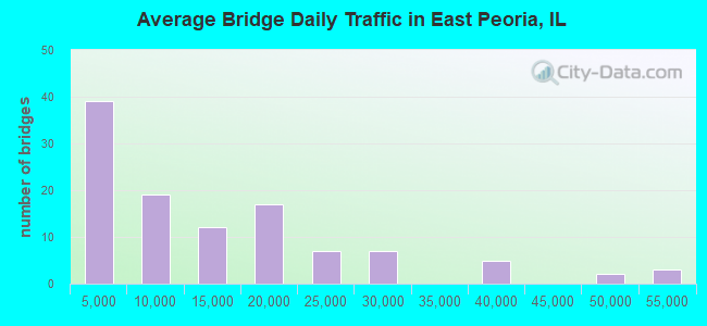
- 1,444,575Total average daily traffic
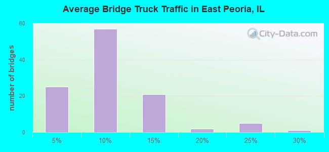
- 118,083Total average daily truck traffic
- National Bridge Inventory (NBI) Registered Bridges for East Peoria
- No street view available for this location
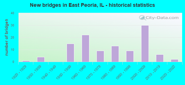
- New bridges - historical statistics
- 11920-1929
- 41930-1939
- 151950-1959
- 221960-1969
- 91970-1979
- 131980-1989
- 91990-1999
- 302000-2009
- 62010-2019
- 22020-2022
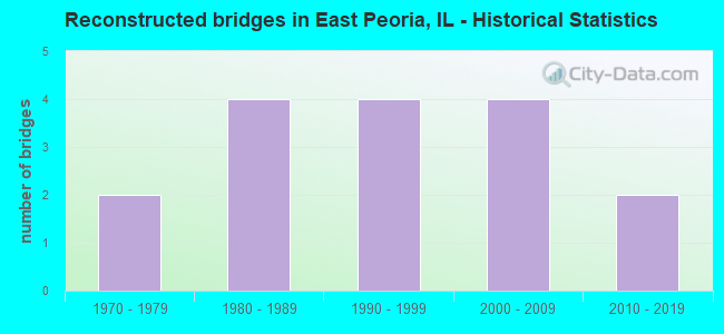
- Reconstructed bridges - Historical Statistics
- 21970-1979
- 41980-1989
- 41990-1999
- 42000-2009
- 22010-2019
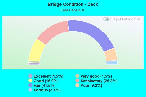
- Bridge Condition - Deck
- 1.5%Excellent
- 1.5%Very good
- 16.9%Good
- 26.2%Satisfactory
- 41.5%Fair
- 9.2%Poor
- 3.1%Serious
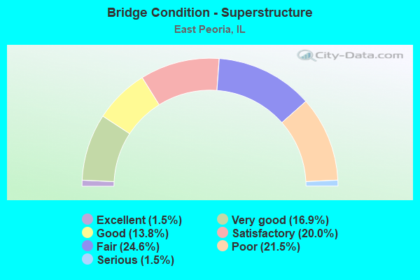
- Bridge Condition - Superstructure
- 1.5%Excellent
- 16.9%Very good
- 13.8%Good
- 20.0%Satisfactory
- 24.6%Fair
- 21.5%Poor
- 1.5%Serious
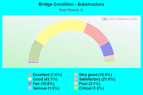
- Bridge Condition - Substructure
- 1.5%Excellent
- 16.9%Very good
- 43.1%Good
- 21.5%Satisfactory
- 10.8%Fair
- 3.1%Poor
- 1.5%Serious
- 1.5%Critical
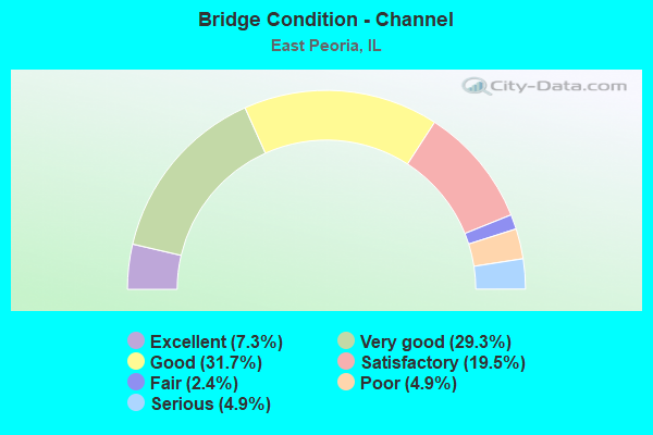
- Bridge Condition - Channel
- 7.3%Excellent
- 29.3%Very good
- 31.7%Good
- 19.5%Satisfactory
- 2.4%Fair
- 4.9%Poor
- 4.9%Serious
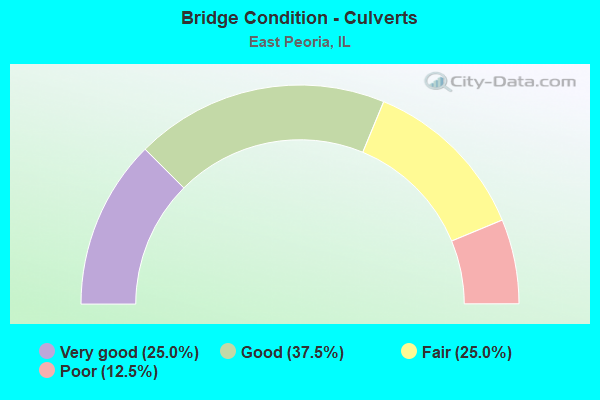
- Bridge Condition - Culverts
- 25.0%Very good
- 37.5%Good
- 25.0%Fair
- 12.5%Poor
Find on map >> Show street view
Structure Number: 900002, Location: 7/8 MI W OF ILL 116 (Lat: 40.678178, Lng: -89.579442), Route carried "on" structure: Interstate 74, Year Built: 1959, Year Reconstructed: 2006, Status: Open, Structure Length: 9.50m (31.17ft), Average Daily Traffic: 26,050 (year 2021), Truck Traffic: 7%, Average Future Daily Traffic: 32,143 (year 2032), Design Load: HS 20+Mod, Features Intersected: DIVERSION CHANNEL
Minimum Vertical Clearance: 30+ m (98+ ft), Kilometerpoint: 154.879, Lanes on structure: 3, Base Highway Network: Yes, Owner: State Highway Agency, Approaching Roadway Width: 20.7m (67.9ft), Skew: 4 degrees, Material/Design: Steel continuous, Design/Construction: Stringer/Multi-beam, Number Of Spans In Main Unit: 3, Length of Maximum Span: 43.6m (143.0ft), Curb-To-Curb Width: 18.6m (61.0ft), Out-to-Out Width: 20.3m (66.6ft)
Condition: Deck: Satisfactory, Superstructure: Satisfactory, Substructure: Good, Channel: Good, Operating Rating: 81.0 metric tons, Method Used To Determine Operating Rating: Load Factor (LF) rating reported by rating factor (RF) method using MS18 loading, Inventory Rating: 48.6 metric tons, Method Used To Determine Inventory Rating: Load Factor (LF) rating reported by rating factor (RF) method using MS18 loading, Structural Evaluation: Equal to present minimum criteria, Deck Geometry: Superior to present desirable criteria, Waterway Adequacy: Superior to present desirable criteria, Approach Roadway Alignment: Equal to present desirable criteria, Length Of Structure Improvement: 9.63m (31.59ft), Designated Inspection Frequency: Every 24 months, Inspection Date: April 2021, Bridge Improvement Cost: $869,000, Roadway Improvement Cost: $87,000, Total Project Cost: $1,304,000, Deck Structure Type: Concrete Cast-file-Place, Wearing Surface/Protective System: Deck Protection: Epoxy Coated Reinforcing
Find on map >> Show street view
Structure Number: 900003, Location: 7/8 MI W OF ILL 116 (Lat: 40.678000, Lng: -89.579328), Route carried "on" structure: Interstate 74, Year Built: 1959, Year Reconstructed: 2006, Status: Open, Structure Length: 9.50m (31.17ft), Average Daily Traffic: 26,050 (year 2021), Truck Traffic: 7%, Average Future Daily Traffic: 32,143 (year 2032), Design Load: HS 20+Mod, Features Intersected: DIVERSION CHANNEL
Minimum Vertical Clearance: 30+ m (98+ ft), Kilometerpoint: 154.895, Lanes on structure: 3, Base Highway Network: Yes, Owner: State Highway Agency, Approaching Roadway Width: 20.7m (67.9ft), Skew: 4 degrees, Material/Design: Steel continuous, Design/Construction: Stringer/Multi-beam, Number Of Spans In Main Unit: 3, Length of Maximum Span: 43.6m (143.0ft), Curb-To-Curb Width: 18.6m (61.0ft), Out-to-Out Width: 20.3m (66.6ft)
Condition: Deck: Satisfactory, Superstructure: Good, Substructure: Good, Channel: Good, Operating Rating: 86.5 metric tons, Method Used To Determine Operating Rating: Load Factor (LF) rating reported by rating factor (RF) method using MS18 loading, Inventory Rating: 51.8 metric tons, Method Used To Determine Inventory Rating: Load Factor (LF) rating reported by rating factor (RF) method using MS18 loading, Structural Evaluation: Better than present minimum criteria, Deck Geometry: Superior to present desirable criteria, Waterway Adequacy: Superior to present desirable criteria, Approach Roadway Alignment: Equal to present minimum criteria, Length Of Structure Improvement: 9.63m (31.59ft), Designated Inspection Frequency: Every 24 months, Inspection Date: April 2021, Bridge Improvement Cost: $869,000, Roadway Improvement Cost: $87,000, Total Project Cost: $1,304,000, Deck Structure Type: Concrete Cast-file-Place, Wearing Surface/Protective System: Deck Protection: Epoxy Coated Reinforcing
Find on map >> Show street view
Structure Number: 900008, Location: .5 MI E OF ILL 116 (Lat: 40.666478, Lng: -89.570994), Route carried "on" structure: Interstate 74, Year Built: 1959, Status: Open, Structure Length: 26.00m (85.30ft), Average Daily Traffic: 18,650 (year 2021), Truck Traffic: 10%, Average Future Daily Traffic: 22,683 (year 2032), Design Load: HS 20+Mod, Features Intersected: US 150,FARM CR&RRS
Minimum Vertical Clearance: 30+ m (98+ ft), Kilometerpoint: 156.376, Lanes on structure: 2, Lanes under structure: 2, Base Highway Network: Yes, Owner: State Highway Agency, Approaching Roadway Width: 11.0m (36.1ft), Skew: 3 degrees, Material/Design: Steel continuous, Design/Construction: Stringer/Multi-beam, Number Of Spans In Main Unit: 8, Number Of Approach Spans: 1, Length of Maximum Span: 46.9m (153.9ft), Curb-To-Curb Width: 9.0m (29.5ft), Out-to-Out Width: 11.0m (36.1ft)
Condition: Deck: Fair, Superstructure: Fair, Substructure: Satisfactory, Channel: Very good, Operating Rating: 82.6 metric tons, Method Used To Determine Operating Rating: Load Factor (LF) rating reported by rating factor (RF) method using MS18 loading, Inventory Rating: 49.6 metric tons, Method Used To Determine Inventory Rating: Load Factor (LF) rating reported by rating factor (RF) method using MS18 loading, Structural Evaluation: Somewhat better than minimum adequacy, Deck Geometry: Meets minimum limits, Underclear: Meets minimum limits, Waterway Adequacy: Superior to present desirable criteria, Approach Roadway Alignment: Equal to present minimum criteria, Designated Inspection Frequency: Every 24 months, Other Special Inspection Frequency: Every 24 months, Inspection Date: April 2020, Other Special Inspection Date: Febuary 2021, Deck Structure Type: Concrete Cast-file-Place, Wearing Surface/Protective System: Deck Protection: Epoxy Coated Reinforcing
Find on map >> Show street view
Structure Number: 900009, Location: .5 MI E OF ILL 116 (Lat: 40.666319, Lng: -89.570886), Route carried "on" structure: Interstate 74, Year Built: 1959, Year Reconstructed: 2006, Status: Open, Structure Length: 24.48m (80.31ft), Average Daily Traffic: 18,650 (year 2021), Truck Traffic: 10%, Average Future Daily Traffic: 22,683 (year 2032), Design Load: HS 20, Features Intersected: US150,FARM CR& RRS
Minimum Vertical Clearance: 30+ m (98+ ft), Kilometerpoint: 156.392, Lanes on structure: 3, Lanes under structure: 2, Base Highway Network: Yes, Owner: State Highway Agency, Approaching Roadway Width: 13.8m (45.3ft), Skew: 3 degrees, Material/Design: Steel continuous, Design/Construction: Stringer/Multi-beam, Number Of Spans In Main Unit: 8, Length of Maximum Span: 46.9m (153.9ft), Curb-To-Curb Width: 13.8m (45.3ft), Out-to-Out Width: 14.3m (46.9ft)
Condition: Deck: Fair, Superstructure: Fair, Substructure: Good, Channel: Good, Operating Rating: 70.3 metric tons, Method Used To Determine Operating Rating: Load Factor (LF) rating reported by rating factor (RF) method using MS18 loading, Inventory Rating: 42.1 metric tons, Method Used To Determine Inventory Rating: Load Factor (LF) rating reported by rating factor (RF) method using MS18 loading, Structural Evaluation: Somewhat better than minimum adequacy, Deck Geometry: Meets minimum limits, Underclear: Better than present minimum criteria, Waterway Adequacy: Superior to present desirable criteria, Approach Roadway Alignment: Equal to present minimum criteria, Designated Inspection Frequency: Every 24 months, Other Special Inspection Frequency: Every 24 months, Inspection Date: April 2021, Other Special Inspection Date: Febuary 2021, Deck Structure Type: Concrete Cast-file-Place, Wearing Surface/Protective System: Deck Protection: Epoxy Coated Reinforcing
Find on map >> Show street view
Structure Number: 900027, Location: E PEO-ILL8 & 116 (Lat: 40.671536, Lng: -89.580272), Route carried "on" structure: Other road , Year Built: 1930, Year Reconstructed: 2012, Status: Open, Structure Length: 3.34m (10.96ft), Average Daily Traffic: 6,200 (year 2018), Truck Traffic: 5%, Average Future Daily Traffic: 17,093 (year 2032), Design Load: HS 20, Features Intersected: FARM CREEK, Facility Carried by Structure: CAMP STREET-FAU671
Minimum Vertical Clearance: 30+ m (98+ ft), Kilometerpoint: 1.561, Lanes on structure: 2, Base Highway Network: Yes, Owner: City or Municipal Highway Agency, Approaching Roadway Width: 18.3m (60.0ft), Skew: 3 degrees, Material/Design: Steel, Design/Construction: Stringer/Multi-beam, Number Of Spans In Main Unit: 1, Length of Maximum Span: 31.6m (103.7ft), Curb-To-Curb Width: 19.5m (64.0ft), Out-to-Out Width: 20.5m (67.3ft)
Condition: Deck: Good, Superstructure: Very good, Substructure: Good, Channel: Very good, Operating Rating: 64.8 metric tons, Method Used To Determine Operating Rating: Load Factor (LF) rating reported by rating factor (RF) method using MS18 loading, Inventory Rating: 38.9 metric tons, Method Used To Determine Inventory Rating: Load Factor (LF) rating reported by rating factor (RF) method using MS18 loading, Structural Evaluation: Better than present minimum criteria, Deck Geometry: Superior to present desirable criteria, Waterway Adequacy: Equal to present desirable criteria, Approach Roadway Alignment: Equal to present desirable criteria, Designated Inspection Frequency: Every 24 months, Inspection Date: April 2020, Deck Structure Type: Concrete Cast-file-Place, Wearing Surface/Protective System: Deck Protection: Epoxy Coated Reinforcing
Find on map >> Show street view
Structure Number: 900031, Location: CEDAR ST EXTENSION (Lat: 40.672678, Lng: -89.594528), Route carried "on" structure: State highway 8, Year Built: 1966, Status: Open, Structure Length: 5.70m (18.70ft), Average Daily Traffic: 12,400 (year 2021), Truck Traffic: 5%, Average Future Daily Traffic: 11,825 (year 2032), Design Load: HS 20, Features Intersected: RICHLAND ST.
Minimum Vertical Clearance: 30+ m (98+ ft), Kilometerpoint: 55.537, Lanes on structure: 4, Lanes under structure: 2, Base Highway Network: Yes, Owner: State Highway Agency, Approaching Roadway Width: 22.6m (74.1ft), Skew: 34 degrees, Material/Design: Steel continuous, Design/Construction: Stringer/Multi-beam, Number Of Spans In Main Unit: 3, Length of Maximum Span: 24.4m (80.1ft), Curb-To-Curb Width: 18.6m (61.0ft), Out-to-Out Width: 21.1m (69.2ft)
Condition: Deck: Serious, Superstructure: Poor, Substructure: Fair, Operating Rating: 95.3 metric tons, Method Used To Determine Operating Rating: Load Factor (LF) rating reported by rating factor (RF) method using MS18 loading, Inventory Rating: 47.6 metric tons, Method Used To Determine Inventory Rating: Load Factor (LF) rating reported by rating factor (RF) method using MS18 loading, Structural Evaluation: Meets minimum limits, Deck Geometry: Equal to present minimum criteria, Underclear: Somewhat better than minimum adequacy, Approach Roadway Alignment: Equal to present minimum criteria, Designated Inspection Frequency: Every 12 months, Other Special Inspection Frequency: Every 6 months, Inspection Date: Febuary 2021, Other Special Inspection Date: August 2021, Deck Structure Type: Concrete Cast-file-Place, Wearing Surface/Protective System: Wearing Surface: Bituminous, Membrane: Built-up
Find on map >> Show street view
Structure Number: 900032, Location: CEDAR ST EXTENSION (Lat: 40.669350, Lng: -89.590511), Route carried "on" structure: State highway 8, Year Built: 1966, Status: Open, Structure Length: 5.39m (17.68ft), Average Daily Traffic: 9,100 (year 2021), Truck Traffic: 9%, Average Future Daily Traffic: 9,783 (year 2032), Design Load: HS 20, Features Intersected: EDMUND ST
Minimum Vertical Clearance: 30+ m (98+ ft), Kilometerpoint: 55.955, Lanes on structure: 4, Lanes under structure: 4, Base Highway Network: Yes, Owner: State Highway Agency, Approaching Roadway Width: 20.7m (67.9ft), Skew: 21 degrees, Material/Design: Steel, Design/Construction: Stringer/Multi-beam, Number Of Spans In Main Unit: 3, Length of Maximum Span: 27.7m (90.9ft), Curb-To-Curb Width: 18.4m (60.4ft), Out-to-Out Width: 20.1m (65.9ft)
Condition: Deck: Serious, Superstructure: Poor, Substructure: Poor, Operating Rating: 69.7 metric tons, Method Used To Determine Operating Rating: Load Factor (LF) rating reported by rating factor (RF) method using MS18 loading, Inventory Rating: 37.3 metric tons, Method Used To Determine Inventory Rating: Load Factor (LF) rating reported by rating factor (RF) method using MS18 loading, Structural Evaluation: Meets minimum limits, Deck Geometry: Somewhat better than minimum adequacy, Underclear: Meets minimum limits, Approach Roadway Alignment: Equal to present minimum criteria, Designated Inspection Frequency: Every 12 months, Other Special Inspection Frequency: Every 48 months, Inspection Date: November 2021, Other Special Inspection Date: November 2021, Deck Structure Type: Concrete Cast-file-Place, Wearing Surface/Protective System: Wearing Surface: Bituminous, Membrane: Built-up
Find on map >> Show street view
Structure Number: 900033, Location: CEDAR ST EXTENSION (Lat: 40.667236, Lng: -89.587911), Route carried "on" structure: State highway 8, Year Built: 1962, Status: Open, Structure Length: 5.43m (17.81ft), Average Daily Traffic: 11,800 (year 2021), Truck Traffic: 8%, Average Future Daily Traffic: 9,783 (year 2032), Design Load: HS 20, Features Intersected: CENTER STREET
Minimum Vertical Clearance: 30+ m (98+ ft), Kilometerpoint: 56.261, Lanes on structure: 4, Lanes under structure: 2, Base Highway Network: Yes, Owner: State Highway Agency, Approaching Roadway Width: 20.7m (67.9ft), Skew: 24 degrees, Material/Design: Steel continuous, Design/Construction: Stringer/Multi-beam, Number Of Spans In Main Unit: 3, Length of Maximum Span: 22.6m (74.1ft), Curb-To-Curb Width: 20.1m (65.9ft), Out-to-Out Width: 23.8m (78.1ft)
Condition: Deck: Poor, Superstructure: Poor, Substructure: Fair, Operating Rating: 71.6 metric tons, Method Used To Determine Operating Rating: Load Factor (LF) rating reported by rating factor (RF) method using MS18 loading, Inventory Rating: 37.6 metric tons, Method Used To Determine Inventory Rating: Load Factor (LF) rating reported by rating factor (RF) method using MS18 loading, Structural Evaluation: Meets minimum limits, Deck Geometry: Better than present minimum criteria, Underclear: Meets minimum limits, Approach Roadway Alignment: Equal to present minimum criteria, Designated Inspection Frequency: Every 12 months, Inspection Date: May 2021, Deck Structure Type: Concrete Cast-file-Place, Wearing Surface/Protective System: Wearing Surface: Bituminous, Membrane: Built-up
Find on map >> Show street view
Structure Number: 900034, Location: CEDAR ST EXTENSION (Lat: 40.665650, Lng: -89.585956), Route carried "on" structure: State highway 8, Year Built: 1966, Status: Open, Structure Length: 21.52m (70.60ft), Average Daily Traffic: 11,800 (year 2021), Truck Traffic: 8%, Average Future Daily Traffic: 14,620 (year 2032), Design Load: HS 20, Features Intersected: Tazewell & Peoria RR
Minimum Vertical Clearance: 30+ m (98+ ft), Kilometerpoint: 56.551, Lanes on structure: 4, Base Highway Network: Yes, Owner: State Highway Agency, Approaching Roadway Width: 20.7m (67.9ft), Skew: 20 degrees, Material/Design: Steel continuous, Design/Construction: Stringer/Multi-beam, Number Of Spans In Main Unit: 6, Length of Maximum Span: 65.2m (213.9ft), Curb or Sidewalk Widths: Left: 0.6m (2.0ft), Right: 0.6m (2.0ft), Curb-To-Curb Width: 16.5m (54.1ft), Out-to-Out Width: 19.3m (63.3ft)
Condition: Deck: Poor, Superstructure: Poor, Substructure: Critical, Operating Rating: 65.8 metric tons, Method Used To Determine Operating Rating: Load Factor (LF) rating reported by rating factor (RF) method using MS18 loading, Inventory Rating: 39.2 metric tons, Method Used To Determine Inventory Rating: Load Factor (LF) rating reported by rating factor (RF) method using MS18 loading, Structural Evaluation: High priority of replacement, Deck Geometry: Meets minimum limits, Underclear: Equal to present minimum criteria, Approach Roadway Alignment: Somewhat better than minimum adequacy, Designated Inspection Frequency: Every 12 months, Other Special Inspection Frequency: Every 6 months, Inspection Date: December 2020, Other Special Inspection Date: June 2021, Deck Structure Type: Concrete Cast-file-Place, Wearing Surface/Protective System: Wearing Surface: Bituminous, Membrane: Built-up
Find on map >> Show street view
Structure Number: 900035, Location: CEDAR ST EXT E PEO (Lat: 40.664156, Lng: -89.584072), Route carried "on" structure: State highway 8, Year Built: 1963, Status: Open, Structure Length: 4.82m (15.81ft), Average Daily Traffic: 11,800 (year 2021), Truck Traffic: 8%, Average Future Daily Traffic: 14,620 (year 2032), Design Load: HS 20, Features Intersected: US 24/ IL 29
Minimum Vertical Clearance: 30+ m (98+ ft), Kilometerpoint: 56.776, Lanes on structure: 4, Lanes under structure: 4, Base Highway Network: Yes, Owner: State Highway Agency, Approaching Roadway Width: 12.2m (40.0ft), Skew: 21 degrees, Material/Design: Steel, Design/Construction: Stringer/Multi-beam, Number Of Spans In Main Unit: 3, Length of Maximum Span: 23.5m (77.1ft), Curb or Sidewalk Widths: Left: 0.6m (2.0ft), Right: 0.6m (2.0ft), Curb-To-Curb Width: 12.9m (42.3ft), Out-to-Out Width: 14.7m (48.2ft)
Condition: Deck: Poor, Superstructure: Poor, Substructure: Serious, Operating Rating: 59.9 metric tons, Method Used To Determine Operating Rating: Load Factor (LF) rating reported by rating factor (RF) method using MS18 loading, Inventory Rating: 31.1 metric tons, Method Used To Determine Inventory Rating: Load Factor (LF) rating reported by rating factor (RF) method using MS18 loading, Structural Evaluation: High priority of corrective action, Deck Geometry: High priority of replacement, Approach Roadway Alignment: Equal to present minimum criteria, Length Of Structure Improvement: 5.79m (19.00ft), Designated Inspection Frequency: Every 12 months, Inspection Date: January 2021, Bridge Improvement Cost: $1,005,000, Roadway Improvement Cost: $101,000, Total Project Cost: $1,508,000, Deck Structure Type: Concrete Cast-file-Place, Wearing Surface/Protective System: Wearing Surface: Bituminous, Membrane: Built-up
Find on map >> Show street view
Structure Number: 900037, Location: MEADOWS AVE E. PEO. (Lat: 40.667656, Lng: -89.560964), Route carried "on" structure: US 150, Year Built: 1935, Year Reconstructed: 1985, Status: Open, Structure Length: 22.56m (74.02ft), Average Daily Traffic: 6,150 (year 2021), Truck Traffic: 3%, Average Future Daily Traffic: 7,095 (year 2032), Design Load: HS 20, Features Intersected: FARM CR TPW NYC RR
Minimum Vertical Clearance: 30+ m (98+ ft), Kilometerpoint: 153.817, Lanes on structure: 4, Lanes under structure: 2, Base Highway Network: Yes, Owner: State Highway Agency, Approaching Roadway Width: 16.5m (54.1ft), Skew: 3 degrees, Material/Design: Steel continuous, Design/Construction: Stringer/Multi-beam, Number Of Spans In Main Unit: 9, Length of Maximum Span: 50.9m (167.0ft), Curb or Sidewalk Widths: Left: 0.0m, Right: 1.8m (5.9ft), Curb-To-Curb Width: 17.6m (57.7ft), Out-to-Out Width: 20.2m (66.3ft)
Condition: Deck: Fair, Superstructure: Fair, Substructure: Fair, Channel: Very good, Operating Rating: 58.6 metric tons, Method Used To Determine Operating Rating: Load Factor (LF) rating reported by rating factor (RF) method using MS18 loading, Inventory Rating: 35.0 metric tons, Method Used To Determine Inventory Rating: Load Factor (LF) rating reported by rating factor (RF) method using MS18 loading, Structural Evaluation: Somewhat better than minimum adequacy, Deck Geometry: Somewhat better than minimum adequacy, Underclear: Superior to present desirable criteria, Waterway Adequacy: Superior to present desirable criteria, Approach Roadway Alignment: Equal to present minimum criteria, Designated Inspection Frequency: Every 24 months, Inspection Date: May 2020, Deck Structure Type: Concrete Cast-file-Place, Wearing Surface/Protective System: Deck Protection: Epoxy Coated Reinforcing
Find on map >> Show street view
Structure Number: 900044, Location: N CAMP ST, E PEORIA (Lat: 40.678386, Lng: -89.585175), Route carried "on" structure: Other road , Year Built: 1959, Year Reconstructed: 1993, Status: Open, Structure Length: 19.66m (64.50ft), Average Daily Traffic: 3,650 (year 2021), Truck Traffic: 8%, Average Future Daily Traffic: 6,558 (year 2032), Design Load: HS 20, Features Intersected: CAMP ST, Facility Carried by Structure: RIVERFRONT DR
Minimum Vertical Clearance: 30+ m (98+ ft), Kilometerpoint: 1.191, Lanes on structure: 4, Lanes under structure: 4, Base Highway Network: Yes, Owner: State Highway Agency, Approaching Roadway Width: 16.9m (55.4ft), Skew: 31 degrees, Material/Design: Steel, Design/Construction: Stringer/Multi-beam, Number Of Spans In Main Unit: 8, Length of Maximum Span: 32.3m (106.0ft), Curb-To-Curb Width: 19.3m (63.3ft), Out-to-Out Width: 21.2m (69.6ft)
Condition: Deck: Fair, Superstructure: Fair, Substructure: Satisfactory, Channel: Very good, Operating Rating: 53.8 metric tons, Method Used To Determine Operating Rating: Load Factor (LF) rating reported by rating factor (RF) method using MS18 loading, Inventory Rating: 32.4 metric tons, Method Used To Determine Inventory Rating: Load Factor (LF) rating reported by rating factor (RF) method using MS18 loading, Structural Evaluation: Somewhat better than minimum adequacy, Deck Geometry: Equal to present minimum criteria, Underclear: Equal to present minimum criteria, Waterway Adequacy: Superior to present desirable criteria, Approach Roadway Alignment: Equal to present minimum criteria, Designated Inspection Frequency: Every 24 months, Inspection Date: Febuary 2020, Deck Structure Type: Concrete Cast-file-Place, Wearing Surface/Protective System: Deck Protection: Epoxy Coated Reinforcing
Find on map >> Show street view
Structure Number: 900046, Location: .5 MI SW OF I-74 (Lat: 40.678392, Lng: -89.588975), Route carried "on" structure: Other road , Year Built: 1958, Status: Open, Structure Length: 5.06m (16.60ft), Average Daily Traffic: 4,200 (year 2021), Truck Traffic: 8%, Average Future Daily Traffic: 6,558 (year 2032), Design Load: HS 20, Features Intersected: WEST WASHINGTON ST, Facility Carried by Structure: RIVERFRONT DR
Minimum Vertical Clearance: 30+ m (98+ ft), Kilometerpoint: 0.901, Lanes on structure: 2, Lanes under structure: 3, Base Highway Network: Yes, Owner: State Highway Agency, Approaching Roadway Width: 17.5m (57.4ft), Skew: 31 degrees, Material/Design: Steel, Design/Construction: Stringer/Multi-beam, Number Of Spans In Main Unit: 3, Length of Maximum Span: 25.6m (84.0ft), Curb-To-Curb Width: 17.5m (57.4ft), Out-to-Out Width: 19.4m (63.6ft)
Condition: Deck: Fair, Superstructure: Fair, Substructure: Good, Operating Rating: 89.1 metric tons, Method Used To Determine Operating Rating: Load Factor (LF) rating reported by rating factor (RF) method using MS18 loading, Inventory Rating: 51.8 metric tons, Method Used To Determine Inventory Rating: Load Factor (LF) rating reported by rating factor (RF) method using MS18 loading, Structural Evaluation: Somewhat better than minimum adequacy, Deck Geometry: Superior to present desirable criteria, Underclear: High priority of corrective action, Approach Roadway Alignment: Equal to present minimum criteria, Designated Inspection Frequency: Every 24 months, Inspection Date: May 2020, Deck Structure Type: Concrete Cast-file-Place, Wearing Surface/Protective System: Deck Protection: Epoxy Coated Reinforcing
Find on map >> Show street view
Structure Number: 900047, Location: MAIN AND CAMP E.PEO. (Lat: 40.668233, Lng: -89.577558), Route carried "on" structure: US 24, Year Built: 1930, Year Reconstructed: 1984, Status: Open, Structure Length: 5.49m (18.01ft), Average Daily Traffic: 24,800 (year 2021), Truck Traffic: 4%, Average Future Daily Traffic: 31,928 (year 2032), Design Load: HS 20, Features Intersected: FARM CREEK, Facility Carried by Structure: ILL 8/116
Minimum Vertical Clearance: 30+ m (98+ ft), Kilometerpoint: 212.202, Lanes on structure: 6, Base Highway Network: Yes, Owner: State Highway Agency, Approaching Roadway Width: 22.6m (74.1ft), Skew: 1 degrees, Material/Design: Steel, Design/Construction: Stringer/Multi-beam, Number Of Spans In Main Unit: 3, Length of Maximum Span: 30.5m (100.1ft), Curb or Sidewalk Widths: Left: 1.5m (4.9ft), Right: 1.5m (4.9ft), Curb-To-Curb Width: 23.2m (76.1ft), Out-to-Out Width: 26.8m (87.9ft)
Condition: Deck: Fair, Superstructure: Fair, Substructure: Satisfactory, Channel: Excellent, Operating Rating: 53.5 metric tons, Method Used To Determine Operating Rating: Load Factor (LF) rating reported by rating factor (RF) method using MS18 loading, Inventory Rating: 31.8 metric tons, Method Used To Determine Inventory Rating: Load Factor (LF) rating reported by rating factor (RF) method using MS18 loading, Structural Evaluation: Somewhat better than minimum adequacy, Deck Geometry: Meets minimum limits, Waterway Adequacy: Superior to present desirable criteria, Approach Roadway Alignment: Equal to present minimum criteria, Designated Inspection Frequency: Every 24 months, Inspection Date: December 2019, Deck Structure Type: Concrete Cast-file-Place, Wearing Surface/Protective System: Deck Protection: Epoxy Coated Reinforcing
Find on map >> Show street view
Structure Number: 900066, Location: ON ILL116 NE FR US24 (Lat: 40.732736, Lng: -89.519097), Route carried "on" structure: State highway 116, Year Built: 1965, Year Reconstructed: 1987, Status: Open, Structure Length: 0.98m (3.22ft), Average Daily Traffic: 15,800 (year 2021), Truck Traffic: 3%, Average Future Daily Traffic: 11,126 (year 2032), Design Load: HS 20, Features Intersected: SPRING CREEK
Minimum Vertical Clearance: 30+ m (98+ ft), Kilometerpoint: 137.708, Lanes on structure: 2, Base Highway Network: Yes, Owner: State Highway Agency, Approaching Roadway Width: 10.4m (34.1ft), Material/Design: Concrete, Design/Construction: Slab, Number Of Spans In Main Unit: 1, Length of Maximum Span: 9.4m (30.8ft), Curb-To-Curb Width: 15.1m (49.5ft), Out-to-Out Width: 15.2m (49.9ft)
Condition: Deck: Poor, Superstructure: Poor, Substructure: Satisfactory, Channel: Poor, Operating Rating: 36.3 metric tons, Method Used To Determine Operating Rating: Load Factor (LF) rating reported by rating factor (RF) method using MS18 loading, Inventory Rating: 21.7 metric tons, Method Used To Determine Inventory Rating: Load Factor (LF) rating reported by rating factor (RF) method using MS18 loading, Structural Evaluation: Meets minimum limits, Deck Geometry: Superior to present desirable criteria, Waterway Adequacy: Equal to present desirable criteria, Approach Roadway Alignment: Equal to present desirable criteria, Designated Inspection Frequency: Every 12 months, Inspection Date: July 2021, Deck Structure Type: Concrete Cast-file-Place, Wearing Surface/Protective System: Wearing Surface: Bituminous, Membrane: Built-up
Find on map >> Show street view
Structure Number: 900067, Location: NEAR JCT ILL 116 26 (Lat: 40.732608, Lng: -89.519172), Route carried "on" structure: State highway 116, Year Built: 1928, Year Reconstructed: 1987, Status: Open, Structure Length: 1.01m (3.31ft), Average Daily Traffic: 15,800 (year 2021), Truck Traffic: 3%, Average Future Daily Traffic: 11,126 (year 2032), Design Load: H 20, Features Intersected: SPRING CREEK
Minimum Vertical Clearance: 30+ m (98+ ft), Kilometerpoint: 137.692, Lanes on structure: 2, Base Highway Network: Yes, Owner: State Highway Agency, Approaching Roadway Width: 10.4m (34.1ft), Skew: 20 degrees, Material/Design: Concrete, Design/Construction: Slab, Number Of Spans In Main Unit: 1, Length of Maximum Span: 9.4m (30.8ft), Curb-To-Curb Width: 23.8m (78.1ft), Out-to-Out Width: 24.0m (78.7ft)
Condition: Deck: Poor, Superstructure: Poor, Substructure: Fair, Channel: Serious, Operating Rating: 54.4 metric tons, Method Used To Determine Operating Rating: Load Factor (LF) rating reported by rating factor (RF) method using MS18 loading, Inventory Rating: 32.7 metric tons, Method Used To Determine Inventory Rating: Load Factor (LF) rating reported by rating factor (RF) method using MS18 loading, Structural Evaluation: Meets minimum limits, Deck Geometry: Superior to present desirable criteria, Waterway Adequacy: Equal to present desirable criteria, Approach Roadway Alignment: Equal to present desirable criteria, Designated Inspection Frequency: Every 12 months, Inspection Date: July 2021, Deck Structure Type: Concrete Cast-file-Place, Wearing Surface/Protective System: Wearing Surface: Bituminous, Membrane: Built-up
Find on map >> Show street view
Structure Number: 900069, Location: INTERCHANGE (Lat: 40.716928, Lng: -89.527672), Route carried "on" structure: Other road , Year Built: 1964, Year Reconstructed: 1998, Status: Open, Structure Length: 6.16m (20.21ft), Average Daily Traffic: 3,500 (year 2018), Truck Traffic: 5%, Average Future Daily Traffic: 4,085 (year 2032), Design Load: HS 20, Features Intersected: ILL 116, Facility Carried by Structure: RAMP FR ILL116 TO1
Minimum Vertical Clearance: 30+ m (98+ ft), Kilometerpoint: 0.531, Lanes on structure: 1, Lanes under structure: 4, Base Highway Network: Yes (Inventory Route: 20673040, Subroute: 10), Owner: State Highway Agency, Approaching Roadway Width: 9.8m (32.2ft), Material/Design: Steel continuous, Design/Construction: Stringer/Multi-beam, Number Of Spans In Main Unit: 4, Length of Maximum Span: 17.8m (58.4ft), Curb-To-Curb Width: 9.8m (32.2ft), Out-to-Out Width: 10.7m (35.1ft)
Condition: Deck: Satisfactory, Superstructure: Satisfactory, Substructure: Fair, Operating Rating: 89.1 metric tons, Method Used To Determine Operating Rating: Load Factor (LF) rating reported by rating factor (RF) method using MS18 loading, Inventory Rating: 76.1 metric tons, Method Used To Determine Inventory Rating: Load Factor (LF) rating reported by rating factor (RF) method using MS18 loading, Structural Evaluation: Somewhat better than minimum adequacy, Deck Geometry: Meets minimum limits, Underclear: High priority of corrective action, Approach Roadway Alignment: Equal to present minimum criteria, Length Of Structure Improvement: 6.16m (20.21ft), Designated Inspection Frequency: Every 24 months, Inspection Date: October 2020, Bridge Improvement Cost: $315,000, Roadway Improvement Cost: $32,000, Total Project Cost: $473,000, Deck Structure Type: Concrete Cast-file-Place, Wearing Surface/Protective System: Deck Protection: Epoxy Coated Reinforcing
Find on map >> Show street view
Structure Number: 900071, Location: INTERCHANGE 24&116 (Lat: 40.715128, Lng: -89.529317), Route carried "on" structure: US 24, Year Built: 1962, Year Reconstructed: 2019, Status: Open, Structure Length: 7.53m (24.70ft), Average Daily Traffic: 19,200 (year 2021), Truck Traffic: 5%, Average Future Daily Traffic: 14,781 (year 2032), Design Load: HS 20, Features Intersected: ILL 116
Minimum Vertical Clearance: 30+ m (98+ ft), Kilometerpoint: 218.994, Lanes on structure: 2, Lanes under structure: 4, Base Highway Network: Yes, Owner: State Highway Agency, Approaching Roadway Width: 14.6m (47.9ft), Skew: 1 degrees, Material/Design: Steel continuous, Design/Construction: Stringer/Multi-beam, Number Of Spans In Main Unit: 3, Number Of Approach Spans: 1, Length of Maximum Span: 23.2m (76.1ft), Curb-To-Curb Width: 14.6m (47.9ft), Out-to-Out Width: 15.6m (51.2ft)
Condition: Deck: Satisfactory, Superstructure: Poor, Substructure: Good, Operating Rating: 89.1 metric tons, Method Used To Determine Operating Rating: Load Factor (LF) rating reported by rating factor (RF) method using MS18 loading, Inventory Rating: 45.4 metric tons, Method Used To Determine Inventory Rating: Load Factor (LF) rating reported by rating factor (RF) method using MS18 loading, Structural Evaluation: Meets minimum limits, Deck Geometry: Superior to present desirable criteria, Underclear: Meets minimum limits, Approach Roadway Alignment: Equal to present minimum criteria, Length Of Structure Improvement: 11.31m (37.11ft), Designated Inspection Frequency: Every 12 months, Inspection Date: October 2021, Bridge Improvement Cost: $1,864,000, Roadway Improvement Cost: $187,000, Total Project Cost: $2,795,000, Deck Structure Type: Concrete Cast-file-Place, Wearing Surface/Protective System: Deck Protection: Epoxy Coated Reinforcing
Find on map >> Show street view
Structure Number: 900072, Location: INTERCHANGE RT24&116 (Lat: 40.715092, Lng: -89.529053), Route carried "on" structure: US 24, Year Built: 1962, Year Reconstructed: 2019, Status: Open, Structure Length: 7.53m (24.70ft), Average Daily Traffic: 19,200 (year 2021), Truck Traffic: 5%, Average Future Daily Traffic: 14,781 (year 2032), Design Load: HS 20, Features Intersected: ILL 116
Minimum Vertical Clearance: 30+ m (98+ ft), Kilometerpoint: 219.010, Lanes on structure: 2, Lanes under structure: 4, Base Highway Network: Yes, Owner: State Highway Agency, Approaching Roadway Width: 11.6m (38.1ft), Skew: 1 degrees, Material/Design: Steel continuous, Design/Construction: Stringer/Multi-beam, Number Of Spans In Main Unit: 3, Length of Maximum Span: 23.2m (76.1ft), Curb-To-Curb Width: 11.6m (38.1ft), Out-to-Out Width: 12.6m (41.3ft)
Condition: Deck: Satisfactory, Superstructure: Fair, Substructure: Good, Operating Rating: 87.5 metric tons, Method Used To Determine Operating Rating: Load Factor (LF) rating reported by rating factor (RF) method using MS18 loading, Inventory Rating: 43.4 metric tons, Method Used To Determine Inventory Rating: Load Factor (LF) rating reported by rating factor (RF) method using MS18 loading, Structural Evaluation: Somewhat better than minimum adequacy, Deck Geometry: Better than present minimum criteria, Underclear: Somewhat better than minimum adequacy, Approach Roadway Alignment: Equal to present minimum criteria, Designated Inspection Frequency: Every 24 months, Inspection Date: October 2021, Deck Structure Type: Concrete Cast-file-Place, Wearing Surface/Protective System: Deck Protection: Epoxy Coated Reinforcing
Find on map >> Show street view
Structure Number: 900073, Location: .75mi E McClugage Br (Lat: 40.714881, Lng: -89.526606), Route carried "on" structure: US 24, Year Built: 1961, Year Reconstructed: 1998, Status: Open, Structure Length: 3.35m (10.99ft), Average Daily Traffic: 19,200 (year 2021), Truck Traffic: 5%, Average Future Daily Traffic: 14,781 (year 2032), Design Load: HS 20, Features Intersected: RAMP FR ILL116 TO150
Minimum Vertical Clearance: 30+ m (98+ ft), Kilometerpoint: 219.251, Lanes on structure: 2, Lanes under structure: 1, Base Highway Network: Yes, Owner: State Highway Agency, Approaching Roadway Width: 11.6m (38.1ft), Material/Design: Steel continuous, Design/Construction: Stringer/Multi-beam, Number Of Spans In Main Unit: 3, Length of Maximum Span: 13.4m (44.0ft), Curb-To-Curb Width: 11.7m (38.4ft), Out-to-Out Width: 12.6m (41.3ft)
Condition: Deck: Satisfactory, Superstructure: Fair, Substructure: Fair, Operating Rating: 57.3 metric tons, Method Used To Determine Operating Rating: Load Factor (LF) rating reported by rating factor (RF) method using MS18 loading, Inventory Rating: 34.3 metric tons, Method Used To Determine Inventory Rating: Load Factor (LF) rating reported by rating factor (RF) method using MS18 loading, Structural Evaluation: Somewhat better than minimum adequacy, Deck Geometry: Better than present minimum criteria, Underclear: Meets minimum limits, Approach Roadway Alignment: Equal to present desirable criteria, Designated Inspection Frequency: Every 24 months, Inspection Date: October 2021, Deck Structure Type: Concrete Cast-file-Place, Wearing Surface/Protective System: Deck Protection: Epoxy Coated Reinforcing
Find on map >> Show street view
Structure Number: 900074, Location: .75mi E McClugage Br (Lat: 40.714869, Lng: -89.526311), Route carried "on" structure: US 24, Year Built: 1961, Year Reconstructed: 1998, Status: Open, Structure Length: 3.35m (10.99ft), Average Daily Traffic: 19,200 (year 2021), Truck Traffic: 5%, Average Future Daily Traffic: 14,781 (year 2032), Design Load: HS 20, Features Intersected: RAMP FR IL116 TO 150
Minimum Vertical Clearance: 30+ m (98+ ft), Kilometerpoint: 219.267, Lanes on structure: 2, Lanes under structure: 1, Base Highway Network: Yes, Owner: State Highway Agency, Approaching Roadway Width: 11.6m (38.1ft), Material/Design: Steel continuous, Design/Construction: Stringer/Multi-beam, Number Of Spans In Main Unit: 3, Length of Maximum Span: 12.5m (41.0ft), Curb-To-Curb Width: 11.7m (38.4ft), Out-to-Out Width: 12.6m (41.3ft)
Condition: Deck: Satisfactory, Superstructure: Fair, Substructure: Satisfactory, Operating Rating: 57.3 metric tons, Method Used To Determine Operating Rating: Load Factor (LF) rating reported by rating factor (RF) method using MS18 loading, Inventory Rating: 34.3 metric tons, Method Used To Determine Inventory Rating: Load Factor (LF) rating reported by rating factor (RF) method using MS18 loading, Structural Evaluation: Somewhat better than minimum adequacy, Deck Geometry: Better than present minimum criteria, Underclear: Somewhat better than minimum adequacy, Approach Roadway Alignment: Equal to present desirable criteria, Designated Inspection Frequency: Every 24 months, Inspection Date: October 2021, Deck Structure Type: Concrete Cast-file-Place, Wearing Surface/Protective System: Deck Protection: Epoxy Coated Reinforcing
Find on map >> Show street view
Structure Number: 900089, Location: JUST E ILL-116 INTER (Lat: 40.669447, Lng: -89.571669), Route carried "on" structure: Other road , Year Built: 1958, Year Reconstructed: 1997, Status: Open, Structure Length: 13.47m (44.19ft), Average Daily Traffic: 650 (year 2018), Truck Traffic: 11%, Average Future Daily Traffic: 860 (year 2032), Design Load: HS 20, Features Intersected: I-74, Facility Carried by Structure: FONDULAC DR
Minimum Vertical Clearance: 30+ m (98+ ft), Kilometerpoint: 2.961, Lanes on structure: 2, Lanes under structure: 6, Owner: State Highway Agency, Approaching Roadway Width: 11.0m (36.1ft), Material/Design: Steel continuous, Design/Construction: Truss - Deck, Number Of Spans In Main Unit: 3, Length of Maximum Span: 73.2m (240.2ft), Curb-To-Curb Width: 8.8m (28.9ft), Out-to-Out Width: 9.8m (32.2ft)
Condition: Deck: Fair, Superstructure: Poor, Substructure: Satisfactory, Operating Rating: 49.9 metric tons, Method Used To Determine Operating Rating: Load Factor (LF) rating reported by rating factor (RF) method using MS18 loading, Inventory Rating: 29.8 metric tons, Method Used To Determine Inventory Rating: Load Factor (LF) rating reported by rating factor (RF) method using MS18 loading, Structural Evaluation: Meets minimum limits, Deck Geometry: Somewhat better than minimum adequacy, Underclear: Better than present minimum criteria, Approach Roadway Alignment: Equal to present minimum criteria, Designated Inspection Frequency: Every 12 months, Critical Feature Inspection Frequency: Every 12 months, Inspection Date: September 2021, Critical Feature Inspection Date: September 2021, Deck Structure Type: Concrete Cast-file-Place, Wearing Surface/Protective System: Deck Protection: Epoxy Coated Reinforcing
Find on map >> Show street view
Structure Number: 900102, Location: 2 MI W OF MORTON (Lat: 40.633067, Lng: -89.522864), Route carried "on" structure: Interstate 474, Year Built: 1979, Status: Open, Structure Length: 10.76m (35.30ft), Average Daily Traffic: 7,900 (year 2021), Truck Traffic: 24%, Average Future Daily Traffic: 8,923 (year 2032), Design Load: HS 20+Mod, Features Intersected: EB I-74
Minimum Vertical Clearance: 30+ m (98+ ft), Kilometerpoint: 23.142, Lanes on structure: 2, Lanes under structure: 2, Base Highway Network: Yes, Owner: State Highway Agency, Approaching Roadway Width: 12.8m (42.0ft), Skew: 6 degrees, Material/Design: Steel continuous, Design/Construction: Stringer/Multi-beam, Number Of Spans In Main Unit: 3, Length of Maximum Span: 54.3m (178.1ft), Curb-To-Curb Width: 12.2m (40.0ft), Out-to-Out Width: 13.2m (43.3ft)
Condition: Deck: Fair, Superstructure: Poor, Substructure: Satisfactory, Operating Rating: 63.2 metric tons, Method Used To Determine Operating Rating: Load Factor (LF) rating reported by rating factor (RF) method using MS18 loading, Inventory Rating: 37.6 metric tons, Method Used To Determine Inventory Rating: Load Factor (LF) rating reported by rating factor (RF) method using MS18 loading, Structural Evaluation: Meets minimum limits, Deck Geometry: Better than present minimum criteria, Underclear: Better than present minimum criteria, Approach Roadway Alignment: Equal to present desirable criteria, Designated Inspection Frequency: Every 12 months, Inspection Date: September 2021, Deck Structure Type: Concrete Cast-file-Place, Wearing Surface/Protective System: Deck Protection: Epoxy Coated Reinforcing
Find on map >> Show street view
Structure Number: 900103, Location: NEAR CTR 10 GROVELND (Lat: 40.631964, Lng: -89.541175), Route carried "on" structure: Other road , Year Built: 1979, Year Reconstructed: 1983, Status: Open, Structure Length: 7.69m (25.23ft), Average Daily Traffic: 6,300 (year 2018), Truck Traffic: 5%, Average Future Daily Traffic: 5,913 (year 2032), Design Load: HS 20, Features Intersected: I-474, Facility Carried by Structure: FAU 6720 (PINECRES
Minimum Vertical Clearance: 30+ m (98+ ft), Kilometerpoint: 3.862, Lanes on structure: 4, Lanes under structure: 4, Base Highway Network: Yes, Owner: State Highway Agency, Approaching Roadway Width: 13.4m (44.0ft), Skew: 30 degrees, Material/Design: Prestressed concrete continuous, Design/Construction: Stringer/Multi-beam, Number Of Spans In Main Unit: 2, Number Of Approach Spans: 2, Length of Maximum Span: 29.9m (98.1ft), Curb-To-Curb Width: 17.9m (58.7ft), Out-to-Out Width: 18.6m (61.0ft)
Condition: Deck: Fair, Superstructure: Fair, Substructure: Satisfactory, Operating Rating: 65.8 metric tons, Method Used To Determine Operating Rating: Load Factor (LF) rating reported by rating factor (RF) method using MS18 loading, Inventory Rating: 36.9 metric tons, Method Used To Determine Inventory Rating: Load Factor (LF) rating reported by rating factor (RF) method using MS18 loading, Structural Evaluation: Somewhat better than minimum adequacy, Deck Geometry: Somewhat better than minimum adequacy, Underclear: Somewhat better than minimum adequacy, Approach Roadway Alignment: Equal to present minimum criteria, Designated Inspection Frequency: Every 24 months, Inspection Date: November 2021, Deck Structure Type: Concrete Cast-file-Place, Wearing Surface/Protective System: Deck Protection: Epoxy Coated Reinforcing
Find on map >> Show street view
Structure Number: 900104, Location: .3 MI N OF MULLER RD (Lat: 40.631233, Lng: -89.551036), Route carried "on" structure: Other road , Year Built: 1972, Status: Open, Structure Length: 7.69m (25.23ft), Average Daily Traffic: 5,350 (year 2018), Truck Traffic: 7%, Average Future Daily Traffic: 6,020 (year 2032), Design Load: HS 20, Features Intersected: I-474, Facility Carried by Structure: SPFLD RD FAU 6719
Minimum Vertical Clearance: 30+ m (98+ ft), Kilometerpoint: 4.764, Lanes on structure: 2, Lanes under structure: 4, Base Highway Network: Yes, Owner: State Highway Agency, Approaching Roadway Width: 12.2m (40.0ft), Skew: 1 degrees, Material/Design: Steel continuous, Design/Construction: Stringer/Multi-beam, Number Of Spans In Main Unit: 2, Number Of Approach Spans: 2, Length of Maximum Span: 27.4m (89.9ft), Curb or Sidewalk Widths: Left: 1.5m (4.9ft), Right: 1.5m (4.9ft), Curb-To-Curb Width: 12.8m (42.0ft), Out-to-Out Width: 16.2m (53.1ft)
Condition: Deck: Fair, Superstructure: Poor, Substructure: Good, Operating Rating: 65.8 metric tons, Method Used To Determine Operating Rating: Allowable Stress (AS) rating reported by rating factor (RF) method using MS18 loading, Inventory Rating: 41.5 metric tons, Method Used To Determine Inventory Rating: Allowable Stress (AS) rating reported by rating factor (RF) method using MS18 loading, Structural Evaluation: Meets minimum limits, Deck Geometry: Somewhat better than minimum adequacy, Underclear: Equal to present minimum criteria, Approach Roadway Alignment: Equal to present minimum criteria, Designated Inspection Frequency: Every 12 months, Inspection Date: May 2021, Deck Structure Type: Concrete Cast-file-Place, Wearing Surface/Protective System: Wearing Surface: Latex Concrete
Find on map >> Show street view
Structure Number: 900105, Location: 0.25 MI N MULLER RD (Lat: 40.630161, Lng: -89.569661), Route carried "on" structure: Other road , Year Built: 1972, Status: Open, Structure Length: 7.27m (23.85ft), Average Daily Traffic: 2,900 (year 2018), Truck Traffic: 2%, Average Future Daily Traffic: 3,010 (year 2032), Design Load: HS 20, Features Intersected: I-474, Facility Carried by Structure: COLE ST
Minimum Vertical Clearance: 30+ m (98+ ft), Kilometerpoint: 4.039, Lanes on structure: 2, Lanes under structure: 4, Owner: State Highway Agency, Approaching Roadway Width: 7.3m (24.0ft), Material/Design: Steel continuous, Design/Construction: Stringer/Multi-beam, Number Of Spans In Main Unit: 2, Number Of Approach Spans: 2, Length of Maximum Span: 26.8m (87.9ft), Curb-To-Curb Width: 13.0m (42.7ft), Out-to-Out Width: 13.9m (45.6ft)
Condition: Deck: Satisfactory, Superstructure: Poor, Substructure: Good, Operating Rating: 50.5 metric tons, Method Used To Determine Operating Rating: Load Factor (LF) rating reported by rating factor (RF) method using MS18 loading, Inventory Rating: 30.1 metric tons, Method Used To Determine Inventory Rating: Load Factor (LF) rating reported by rating factor (RF) method using MS18 loading, Structural Evaluation: Meets minimum limits, Deck Geometry: Equal to present minimum criteria, Underclear: Somewhat better than minimum adequacy, Approach Roadway Alignment: Equal to present desirable criteria, Designated Inspection Frequency: Every 12 months, Inspection Date: May 2021, Deck Structure Type: Concrete Cast-file-Place, Wearing Surface/Protective System: Wearing Surface: Latex Concrete
Find on map >> Show street view
Structure Number: 90011, Location: N JCT ILL 116 & 26 (Lat: 40.738117, Lng: -89.515969), Route carried "on" structure: State highway 116, Year Built: 1971, Status: Open, Structure Length: 4.82m (15.81ft), Average Daily Traffic: 14,900 (year 2021), Truck Traffic: 4%, Average Future Daily Traffic: 9,675 (year 2032), Design Load: HS 20, Features Intersected: TEN MILE CREEK
Minimum Vertical Clearance: 30+ m (98+ ft), Kilometerpoint: 138.368, Lanes on structure: 2, Base Highway Network: Yes, Owner: State Highway Agency, Approaching Roadway Width: 12.2m (40.0ft), Skew: 4 degrees, Material/Design: Steel continuous, Design/Construction: Stringer/Multi-beam, Number Of Spans In Main Unit: 3, Length of Maximum Span: 18.3m (60.0ft), Curb-To-Curb Width: 11.7m (38.4ft), Out-to-Out Width: 12.8m (42.0ft)
Condition: Deck: Fair, Superstructure: Fair, Substructure: Satisfactory, Channel: Good, Operating Rating: 50.5 metric tons, Method Used To Determine Operating Rating: Allowable Stress (AS) rating reported by rating factor (RF) method using MS18 loading, Inventory Rating: 34.3 metric tons, Method Used To Determine Inventory Rating: Allowable Stress (AS) rating reported by rating factor (RF) method using MS18 loading, Structural Evaluation: Somewhat better than minimum adequacy, Deck Geometry: Better than present minimum criteria, Waterway Adequacy: Equal to present desirable criteria, Approach Roadway Alignment: Equal to present desirable criteria, Designated Inspection Frequency: Every 24 months, Other Special Inspection Frequency: Every 12 months, Inspection Date: July 2021, Other Special Inspection Date: July 2021, Deck Structure Type: Concrete Cast-file-Place, Wearing Surface/Protective System: Wearing Surface: Latex Concrete
Find on map >> Show street view
Structure Number: 900116, Location: 1.5 MI W OF I-155 (Lat: 40.629400, Lng: -89.507825), Route carried "on" structure: Other road , Year Built: 1980, Status: Open, Structure Length: 7.86m (25.79ft), Average Daily Traffic: 1,850 (year 2018), Truck Traffic: 5%, Average Future Daily Traffic: 2,258 (year 2032), Design Load: HS 20, Features Intersected: I-74, Facility Carried by Structure: Pleasant Hill Road
Minimum Vertical Clearance: 30+ m (98+ ft), Kilometerpoint: 1.400, Lanes on structure: 2, Lanes under structure: 4, Owner: State Highway Agency, Approaching Roadway Width: 11.0m (36.1ft), Skew: 2 degrees, Material/Design: Steel continuous, Design/Construction: Stringer/Multi-beam, Number Of Spans In Main Unit: 2, Length of Maximum Span: 39.3m (128.9ft), Curb-To-Curb Width: 12.2m (40.0ft), Out-to-Out Width: 13.0m (42.7ft)
Condition: Deck: Fair, Superstructure: Fair, Substructure: Satisfactory, Operating Rating: 67.1 metric tons, Method Used To Determine Operating Rating: Load Factor (LF) rating reported by rating factor (RF) method using MS18 loading, Inventory Rating: 40.2 metric tons, Method Used To Determine Inventory Rating: Load Factor (LF) rating reported by rating factor (RF) method using MS18 loading, Structural Evaluation: Somewhat better than minimum adequacy, Deck Geometry: Better than present minimum criteria, Underclear: Meets minimum limits, Approach Roadway Alignment: Equal to present minimum criteria, Designated Inspection Frequency: Every 24 months, Inspection Date: Febuary 2020, Deck Structure Type: Concrete Cast-file-Place, Wearing Surface/Protective System: Deck Protection: Epoxy Coated Reinforcing
Find on map >> Show street view
Structure Number: 900117, Location: 1 MI W OF I-155 (Lat: 40.626675, Lng: -89.501419), Route carried "on" structure: Other road , Year Built: 1980, Status: Open, Structure Length: 12.74m (41.80ft), Average Daily Traffic: 4,100 (year 2018), Truck Traffic: 4%, Average Future Daily Traffic: 4,193 (year 2032), Design Load: HS 20, Features Intersected: I-74, Facility Carried by Structure: Muller Road
Minimum Vertical Clearance: 30+ m (98+ ft), Kilometerpoint: 5.745, Lanes on structure: 2, Lanes under structure: 4, Owner: State Highway Agency, Approaching Roadway Width: 11.0m (36.1ft), Skew: 5 degrees, Material/Design: Steel continuous, Design/Construction: Stringer/Multi-beam, Number Of Spans In Main Unit: 2, Number Of Approach Spans: 2, Length of Maximum Span: 52.7m (172.9ft), Curb-To-Curb Width: 12.2m (40.0ft), Out-to-Out Width: 13.2m (43.3ft)
Condition: Deck: Poor, Superstructure: Poor, Substructure: Poor, Operating Rating: 56.4 metric tons, Method Used To Determine Operating Rating: Load Factor (LF) rating reported by rating factor (RF) method using MS18 loading, Inventory Rating: 33.7 metric tons, Method Used To Determine Inventory Rating: Load Factor (LF) rating reported by rating factor (RF) method using MS18 loading, Structural Evaluation: Meets minimum limits, Deck Geometry: Equal to present minimum criteria, Underclear: Meets minimum limits, Approach Roadway Alignment: Equal to present minimum criteria, Designated Inspection Frequency: Every 12 months, Inspection Date: Febuary 2021, Deck Structure Type: Concrete Cast-file-Place, Wearing Surface/Protective System: Deck Protection: Epoxy Coated Reinforcing
Find on map >> Show street view
Structure Number: 900118, Location: 3 MI NW OF MORTON (Lat: 40.634122, Lng: -89.528544), Route carried "on" structure: Other road , Year Built: 1980, Status: Open, Structure Length: 11.89m (39.01ft), Average Daily Traffic: 500 (year 2018), Truck Traffic: 14%, Average Future Daily Traffic: 591 (year 2032), Design Load: HS 20, Features Intersected: WB I-474, Facility Carried by Structure: I-474 RP# 461
Minimum Vertical Clearance: 30+ m (98+ ft), Kilometerpoint: 0.821, Lanes on structure: 1, Lanes under structure: 2, Base Highway Network: Yes (Inventory Route: 10474040, Subroute: 10), Owner: State Highway Agency, Approaching Roadway Width: 10.4m (34.1ft), Skew: 2 degrees, Material/Design: Steel continuous, Design/Construction: Stringer/Multi-beam, Number Of Spans In Main Unit: 3, Length of Maximum Span: 56.1m (184.1ft), Curb-To-Curb Width: 9.1m (29.9ft), Out-to-Out Width: 10.1m (33.1ft)
Condition: Deck: Fair, Superstructure: Fair, Substructure: Satisfactory, Operating Rating: 90.1 metric tons, Method Used To Determine Operating Rating: Load Factor (LF) rating reported by rating factor (RF) method using MS18 loading, Inventory Rating: 53.8 metric tons, Method Used To Determine Inventory Rating: Load Factor (LF) rating reported by rating factor (RF) method using MS18 loading, Structural Evaluation: Somewhat better than minimum adequacy, Deck Geometry: Equal to present minimum criteria, Underclear: Equal to present desirable criteria, Approach Roadway Alignment: Equal to present desirable criteria, Designated Inspection Frequency: Every 24 months, Inspection Date: Febuary 2020, Deck Structure Type: Concrete Cast-file-Place, Wearing Surface/Protective System: Deck Protection: Epoxy Coated Reinforcing
Find on map >> Show street view
Structure Number: 900119, Location: 3.5 MI E OF E. PEO. (Lat: 40.636439, Lng: -89.524889), Route carried "on" structure: Other road , Year Built: 1980, Status: Open, Structure Length: 10.03m (32.91ft), Average Daily Traffic: 500 (year 2018), Truck Traffic: 14%, Average Future Daily Traffic: 591 (year 2032), Design Load: HS 20, Features Intersected: I-74, Facility Carried by Structure: I-474 RP# 461
Minimum Vertical Clearance: 30+ m (98+ ft), Kilometerpoint: 1.159, Lanes on structure: 1, Lanes under structure: 4, Base Highway Network: Yes (Inventory Route: 10474040, Subroute: 10), Owner: State Highway Agency, Approaching Roadway Width: 10.4m (34.1ft), Skew: 1 degrees, Material/Design: Steel continuous, Design/Construction: Stringer/Multi-beam, Number Of Spans In Main Unit: 3, Length of Maximum Span: 41.8m (137.1ft), Curb-To-Curb Width: 9.1m (29.9ft), Out-to-Out Width: 10.1m (33.1ft)
Condition: Deck: Fair, Superstructure: Poor, Substructure: Satisfactory, Operating Rating: 70.6 metric tons, Method Used To Determine Operating Rating: Load Factor (LF) rating reported by rating factor (RF) method using MS18 loading, Inventory Rating: 42.1 metric tons, Method Used To Determine Inventory Rating: Load Factor (LF) rating reported by rating factor (RF) method using MS18 loading, Structural Evaluation: Meets minimum limits, Deck Geometry: Equal to present minimum criteria, Underclear: Somewhat better than minimum adequacy, Approach Roadway Alignment: Equal to present desirable criteria, Designated Inspection Frequency: Every 12 months, Inspection Date: Febuary 2021, Deck Structure Type: Concrete Cast-file-Place, Wearing Surface/Protective System: Deck Protection: Epoxy Coated Reinforcing
Find on map >> Show street view
Structure Number: 90012, Location: 1600' S.CAMP ST. (Lat: 40.679650, Lng: -89.588997), Route carried "on" structure: Other road , Year Built: 1993, Status: Open, Structure Length: 6.41m (21.03ft), Average Daily Traffic: 4,200 (year 2021), Truck Traffic: 8%, Average Future Daily Traffic: 6,558 (year 2032), Design Load: HS 20, Features Intersected: FARM CREEK, Facility Carried by Structure: W.WASHINGTON ST
Minimum Vertical Clearance: 30+ m (98+ ft), Kilometerpoint: 0.708, Lanes on structure: 4, Base Highway Network: Yes, Owner: State Highway Agency, Approaching Roadway Width: 19.5m (64.0ft), Skew: 23 degrees, Material/Design: Steel continuous, Design/Construction: Stringer/Multi-beam, Number Of Spans In Main Unit: 3, Length of Maximum Span: 26.5m (86.9ft), Curb or Sidewalk Widths: Left: 0.0m, Right: 1.5m (4.9ft), Curb-To-Curb Width: 23.2m (76.1ft), Out-to-Out Width: 25.5m (83.7ft)
Condition: Deck: Satisfactory, Superstructure: Fair, Substructure: Good, Channel: Good, Operating Rating: 88.1 metric tons, Method Used To Determine Operating Rating: Load Factor (LF) rating reported by rating factor (RF) method using MS18 loading, Inventory Rating: 46.7 metric tons, Method Used To Determine Inventory Rating: Load Factor (LF) rating reported by rating factor (RF) method using MS18 loading, Structural Evaluation: Somewhat better than minimum adequacy, Deck Geometry: Superior to present desirable criteria, Waterway Adequacy: Equal to present desirable criteria, Approach Roadway Alignment: Equal to present minimum criteria, Designated Inspection Frequency: Every 24 months, Inspection Date: November 2021, Deck Structure Type: Concrete Cast-file-Place, Wearing Surface/Protective System: Deck Protection: Epoxy Coated Reinforcing
Find on map >> Show street view
Structure Number: 900124, Location: 0.5 MI E. GRANGE RD (Lat: 40.715014, Lng: -89.473272), Route carried "on" structure: Business US 24, Year Built: 1988, Status: Open, Structure Length: 7.53m (24.70ft), Average Daily Traffic: 3,075 (year 2021), Truck Traffic: 7%, Average Future Daily Traffic: 4,139 (year 2032), Design Load: HS 20, Features Intersected: US 24
Minimum Vertical Clearance: 30+ m (98+ ft), Kilometerpoint: 1.947, Lanes on structure: 1, Lanes under structure: 4, Base Highway Network: Yes, Owner: State Highway Agency, Approaching Roadway Width: 9.1m (29.9ft), Skew: 3 degrees, Material/Design: Steel continuous, Design/Construction: Stringer/Multi-beam, Number Of Spans In Main Unit: 2, Length of Maximum Span: 39.3m (128.9ft), Curb-To-Curb Width: 7.9m (25.9ft), Out-to-Out Width: 8.9m (29.2ft)
Condition: Deck: Satisfactory, Superstructure: Satisfactory, Substructure: Good, Operating Rating: 76.5 metric tons, Method Used To Determine Operating Rating: Load Factor (LF) rating reported by rating factor (RF) method using MS18 loading, Inventory Rating: 46.0 metric tons, Method Used To Determine Inventory Rating: Load Factor (LF) rating reported by rating factor (RF) method using MS18 loading, Structural Evaluation: Equal to present minimum criteria, Deck Geometry: High priority of corrective action, Underclear: Equal to present minimum criteria, Approach Roadway Alignment: Equal to present minimum criteria, Designated Inspection Frequency: Every 24 months, Inspection Date: Febuary 2020, Deck Structure Type: Concrete Cast-file-Place, Wearing Surface/Protective System: Deck Protection: Epoxy Coated Reinforcing
Find on map >> Show street view
Structure Number: 90014, Location: 0.06 MI SW OF IL 40 (Lat: 40.680217, Lng: -89.590769), Route carried "on" structure: City street , Year Built: 1993, Status: Open, Structure Length: 4.62m (15.16ft), Average Daily Traffic: 1,750 (year 2018), Truck Traffic: 14%, Average Future Daily Traffic: 4,246 (year 2032), Design Load: HS 20, Features Intersected: FARM CREEK, Facility Carried by Structure: CAT RIVER RD.
Minimum Vertical Clearance: 30+ m (98+ ft), Kilometerpoint: 0.113, Lanes on structure: 2, Owner: City or Municipal Highway Agency, Approaching Roadway Width: 9.1m (29.9ft), Material/Design: Steel continuous, Design/Construction: Stringer/Multi-beam, Number Of Spans In Main Unit: 3, Length of Maximum Span: 19.8m (65.0ft), Curb-To-Curb Width: 9.1m (29.9ft), Out-to-Out Width: 10.1m (33.1ft)
Condition: Deck: Good, Superstructure: Good, Substructure: Good, Channel: Very good, Operating Rating: 44.4 metric tons, Method Used To Determine Operating Rating: Load Factor (LF) rating reported by rating factor (RF) method using MS18 loading, Inventory Rating: 32.4 metric tons, Method Used To Determine Inventory Rating: Load Factor (LF) rating reported by rating factor (RF) method using MS18 loading, Structural Evaluation: Better than present minimum criteria, Deck Geometry: Somewhat better than minimum adequacy, Waterway Adequacy: Equal to present desirable criteria, Approach Roadway Alignment: Equal to present desirable criteria, Designated Inspection Frequency: Every 48 months, Inspection Date: May 2020, Deck Structure Type: Concrete Cast-file-Place, Wearing Surface/Protective System: Deck Protection: Epoxy Coated Reinforcing
Find on map >> Show street view
Structure Number: 900144, Location: ILL 8 E. PEORIA (Lat: 40.665367, Lng: -89.567056), Route carried "on" structure: Other road , Year Built: 1992, Status: Open, Structure Length: 6.04m (19.82ft), Average Daily Traffic: 8,250 (year 2018), Truck Traffic: 8%, Average Future Daily Traffic: 10,428 (year 2032), Design Load: HS 20, Features Intersected: FARM CREEK, Facility Carried by Structure: EAST WASHINGTON ST
Minimum Vertical Clearance: 30+ m (98+ ft), Kilometerpoint: 2.317, Lanes on structure: 4, Base Highway Network: Yes, Owner: State Highway Agency, Approaching Roadway Width: 18.3m (60.0ft), Skew: 2 degrees, Material/Design: Steel continuous, Design/Construction: Stringer/Multi-beam, Number Of Spans In Main Unit: 3, Length of Maximum Span: 24.4m (80.1ft), Curb or Sidewalk Widths: Left: 2.1m (6.9ft), Right: 2.1m (6.9ft), Curb-To-Curb Width: 19.5m (64.0ft), Out-to-Out Width: 24.4m (80.1ft)
Condition: Deck: Fair, Superstructure: Serious, Substructure: Good, Channel: Very good, Operating Rating: 70.6 metric tons, Method Used To Determine Operating Rating: Load Factor (LF) rating reported by rating factor (RF) method using MS18 loading, Inventory Rating: 37.6 metric tons, Method Used To Determine Inventory Rating: Load Factor (LF) rating reported by rating factor (RF) method using MS18 loading, Structural Evaluation: High priority of corrective action, Deck Geometry: Better than present minimum criteria, Waterway Adequacy: Superior to present desirable criteria, Approach Roadway Alignment: Equal to present minimum criteria, Designated Inspection Frequency: Every 12 months, Inspection Date: April 2021, Deck Structure Type: Concrete Cast-file-Place, Wearing Surface/Protective System: Deck Protection: Epoxy Coated Reinforcing
Find on map >> Show street view
Structure Number: 900148, Location: 3M E 150 & 8 E.PEO. (Lat: 40.650456, Lng: -89.514064), Route carried "on" structure: US 150, Year Built: 1992, Status: Open, Structure Length: 1.49m (4.89ft), Average Daily Traffic: 5,150 (year 2021), Truck Traffic: 6%, Average Future Daily Traffic: 6,235 (year 2032), Design Load: HS 20, Features Intersected: LITTLE FARM CREEK
Minimum Vertical Clearance: 30+ m (98+ ft), Kilometerpoint: 158.516, Lanes on structure: 2, Base Highway Network: Yes, Owner: State Highway Agency, Approaching Roadway Width: 12.2m (40.0ft), Material/Design: Steel continuous, Design/Construction: Stringer/Multi-beam, Number Of Spans In Main Unit: 1, Length of Maximum Span: 14.2m (46.6ft), Curb-To-Curb Width: 12.2m (40.0ft), Out-to-Out Width: 13.2m (43.3ft)
Condition: Deck: Fair, Superstructure: Satisfactory, Substructure: Very good, Channel: Good, Operating Rating: 80.0 metric tons, Method Used To Determine Operating Rating: Load Factor (LF) rating reported by rating factor (RF) method using MS18 loading, Inventory Rating: 48.6 metric tons, Method Used To Determine Inventory Rating: Load Factor (LF) rating reported by rating factor (RF) method using MS18 loading, Structural Evaluation: Equal to present minimum criteria, Deck Geometry: Somewhat better than minimum adequacy, Waterway Adequacy: Superior to present desirable criteria, Approach Roadway Alignment: Equal to present minimum criteria, Designated Inspection Frequency: Every 24 months, Inspection Date: Febuary 2021, Deck Structure Type: Concrete Cast-file-Place, Wearing Surface/Protective System: Deck Protection: Epoxy Coated Reinforcing
Find on map >> Show street view
Structure Number: 900152, Location: EAST PEORIA (Lat: 40.680217, Lng: -89.581383), Route carried "on" structure: State highway 40, Year Built: 2004, Status: Open, Structure Length: 7.13m (23.39ft), Average Daily Traffic: 2,600 (year 2021), Truck Traffic: 7%, Average Future Daily Traffic: 3,440 (year 2032), Design Load: HS 20, Features Intersected: I-74
Minimum Vertical Clearance: 30+ m (98+ ft), Kilometerpoint: 0.064, Lanes on structure: 1, Lanes under structure: 5, Base Highway Network: Yes, Owner: State Highway Agency, Approaching Roadway Width: 8.5m (27.9ft), Skew: 2 degrees, Material/Design: Prestressed concrete continuous, Design/Construction: Stringer/Multi-beam, Number Of Spans In Main Unit: 2, Number Of Approach Spans: 2, Length of Maximum Span: 28.8m (94.5ft), Curb-To-Curb Width: 7.9m (25.9ft), Out-to-Out Width: 8.9m (29.2ft)
Condition: Deck: Satisfactory, Superstructure: Satisfactory, Substructure: Good, Operating Rating: 89.1 metric tons, Method Used To Determine Operating Rating: Load Factor (LF) rating reported by rating factor (RF) method using MS18 loading, Inventory Rating: 61.6 metric tons, Method Used To Determine Inventory Rating: Load Factor (LF) rating reported by rating factor (RF) method using MS18 loading, Structural Evaluation: Equal to present minimum criteria, Deck Geometry: High priority of corrective action, Underclear: Meets minimum limits, Approach Roadway Alignment: Equal to present minimum criteria, Designated Inspection Frequency: Every 24 months, Inspection Date: October 2021, Deck Structure Type: Concrete Cast-file-Place, Wearing Surface/Protective System: Deck Protection: Epoxy Coated Reinforcing