Bridge Statistics for East Peoria, Illinois (IL)
Condition, Traffic, Stress, Structural Evaluation, Project Costs
- National Bridge Inventory (NBI) Statistics
- 111Number of bridges
- 1,686ft / 514mTotal length
- $7,384,000Total costs
- 1,444,575Total average daily traffic
- 118,083Total average daily truck traffic
- National Bridge Inventory (NBI) Registered Bridges for East Peoria
- No street view available for this location
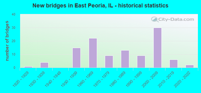
- New bridges - historical statistics
- 11920-1929
- 41930-1939
- 151950-1959
- 221960-1969
- 91970-1979
- 131980-1989
- 91990-1999
- 302000-2009
- 62010-2019
- 22020-2022
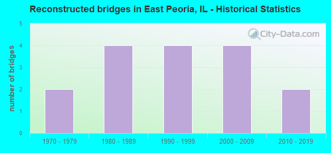
- Reconstructed bridges - Historical Statistics
- 21970-1979
- 41980-1989
- 41990-1999
- 42000-2009
- 22010-2019
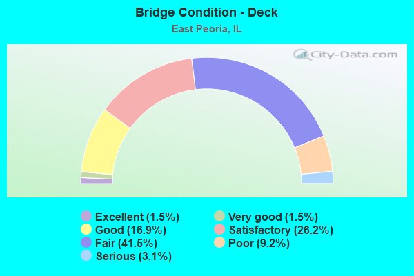
- Bridge Condition - Deck
- 1.5%Excellent
- 1.5%Very good
- 16.9%Good
- 26.2%Satisfactory
- 41.5%Fair
- 9.2%Poor
- 3.1%Serious
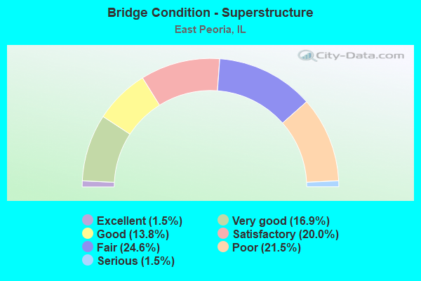
- Bridge Condition - Superstructure
- 1.5%Excellent
- 16.9%Very good
- 13.8%Good
- 20.0%Satisfactory
- 24.6%Fair
- 21.5%Poor
- 1.5%Serious
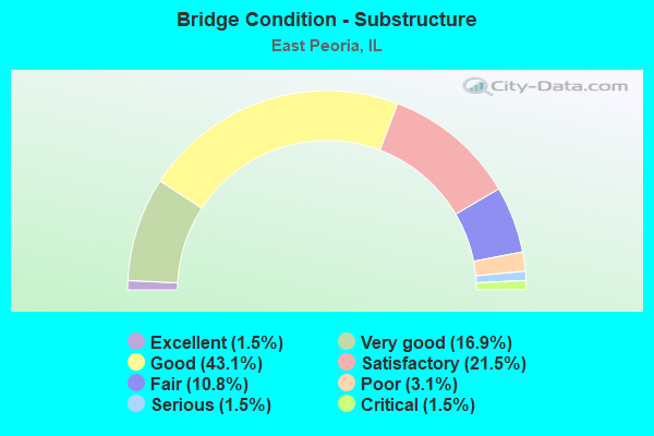
- Bridge Condition - Substructure
- 1.5%Excellent
- 16.9%Very good
- 43.1%Good
- 21.5%Satisfactory
- 10.8%Fair
- 3.1%Poor
- 1.5%Serious
- 1.5%Critical
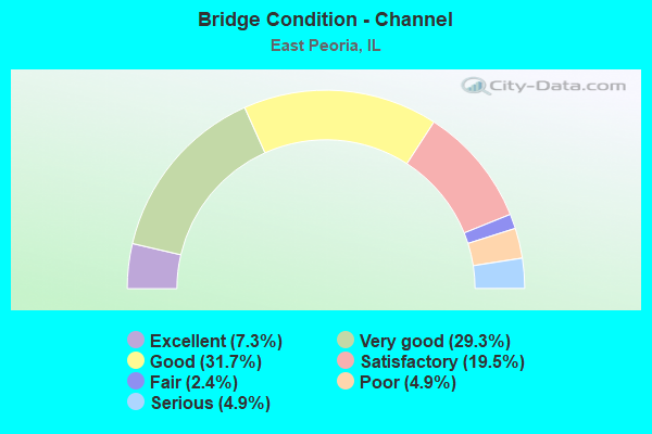
- Bridge Condition - Channel
- 7.3%Excellent
- 29.3%Very good
- 31.7%Good
- 19.5%Satisfactory
- 2.4%Fair
- 4.9%Poor
- 4.9%Serious
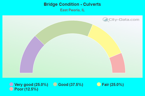
- Bridge Condition - Culverts
- 25.0%Very good
- 37.5%Good
- 25.0%Fair
- 12.5%Poor
Find on map >> Show street view
Structure Number: 900044, Location: N CAMP ST, E PEORIA (Lat: 40.678400, Lng: -89.585739), Route carried "under" structure: Other road , Year Built: 1959, Structure Length: 0. m, Average Daily Traffic: 13,200 (year 2018), Truck Traffic: 4%, Features Intersected: CAMP ST, Facility Carried by Structure: RIVERFRONT DR
Minimum Vertical Clearance: 6.60m (21.65ft), Kilometerpoint: 0.676, Lanes on structure: 4, Lanes under structure: 4, Material/Design: Steel, Design/Construction: Stringer/Multi-beam, Length of Maximum Span: 32.3m (106.0ft)
Find on map >> Show street view
Structure Number: 900046, Location: .5 MI SW OF I-74 (Lat: 40.678161, Lng: -89.588800), Route carried "under" structure: Other road , Year Built: 1958, Structure Length: 0. m, Average Daily Traffic: 9,650 (year 2018), Truck Traffic: 6%, Features Intersected: WEST WASHINGTON ST, Facility Carried by Structure: RIVERFRONT DR
Minimum Vertical Clearance: 4.60m (15.09ft), Kilometerpoint: 0.225, Lanes on structure: 2, Lanes under structure: 3, Material/Design: Steel, Design/Construction: Stringer/Multi-beam, Length of Maximum Span: 25.6m (84.0ft)
Find on map >> Show street view
Structure Number: 900069, Location: INTERCHANGE (Lat: 40.717111, Lng: -89.528197), Route carried "under" structure: State highway 116, Year Built: 1964, Structure Length: 0. m, Average Daily Traffic: 21,200 (year 2021), Truck Traffic: 4%, Features Intersected: ILL 116
Minimum Vertical Clearance: 5.11m (16.77ft), Kilometerpoint: 135.809, Lanes on structure: 1, Lanes under structure: 4, Material/Design: Steel continuous, Design/Construction: Stringer/Multi-beam, Length of Maximum Span: 17.8m (58.4ft)
Find on map >> Show street view
Structure Number: 900071, Location: INTERCHANGE 24&116 (Lat: 40.715128, Lng: -89.529317), Route carried "under" structure: US 24, Year Built: 1962, Structure Length: 0. m, Average Daily Traffic: 20,400 (year 2021), Truck Traffic: 8%, Features Intersected: ILL 116
Minimum Vertical Clearance: 5.77m (18.93ft), Kilometerpoint: 218.994, Lanes on structure: 2, Lanes under structure: 4, Material/Design: Steel continuous, Design/Construction: Stringer/Multi-beam, Length of Maximum Span: 23.2m (76.1ft)
Find on map >> Show street view
Structure Number: 900072, Location: INTERCHANGE RT24&116 (Lat: 40.715303, Lng: -89.529222), Route carried "under" structure: State highway 116, Year Built: 1962, Structure Length: 0. m, Average Daily Traffic: 21,200 (year 2021), Truck Traffic: 4%, Features Intersected: ILL 116, Facility Carried by Structure: WB US 24
Minimum Vertical Clearance: 5.77m (18.93ft), Kilometerpoint: 135.600, Lanes on structure: 2, Lanes under structure: 4, Material/Design: Steel continuous, Design/Construction: Stringer/Multi-beam, Length of Maximum Span: 23.2m (76.1ft)
Find on map >> Show street view
Structure Number: 900073, Location: .75mi E McClugage Br (Lat: 40.715050, Lng: -89.526281), Route carried "under" structure: Other road , Year Built: 1961, Structure Length: 0. m, Average Daily Traffic: 3,500 (year 2018), Truck Traffic: 5%, Features Intersected: RAMP FR ILL116 TO150, Facility Carried by Structure: EB US 24
Minimum Vertical Clearance: 4.47m (14.67ft), Kilometerpoint: 0.257, Lanes on structure: 2, Lanes under structure: 1, Material/Design: Steel continuous, Design/Construction: Stringer/Multi-beam, Length of Maximum Span: 13.4m (44.0ft)
Find on map >> Show street view
Structure Number: 900074, Location: .75mi E McClugage Br (Lat: 40.715178, Lng: -89.526314), Route carried "under" structure: Other road , Year Built: 1961, Structure Length: 0. m, Average Daily Traffic: 3,500 (year 2018), Truck Traffic: 5%, Features Intersected: RAMP FR IL116 TO 150, Facility Carried by Structure: WB US 24
Minimum Vertical Clearance: 4.78m (15.68ft), Kilometerpoint: 0.274, Lanes on structure: 2, Lanes under structure: 1, Material/Design: Steel continuous, Design/Construction: Stringer/Multi-beam, Length of Maximum Span: 12.5m (41.0ft)
Find on map >> Show street view
Structure Number: 900089, Location: JUST E ILL-116 INTER (Lat: 40.668717, Lng: -89.572603), Route carried "under" structure: Interstate 74, Year Built: 1958, Structure Length: 0. m, Average Daily Traffic: 37,300 (year 2021), Truck Traffic: 10%, Features Intersected: I-74, Facility Carried by Structure: FONDULAC DR
Minimum Vertical Clearance: 16.61m (54.49ft), Kilometerpoint: 156.150, Lanes on structure: 2, Lanes under structure: 6, Material/Design: Steel continuous, Design/Construction: Truss - Deck, Length of Maximum Span: 73.2m (240.2ft)
Find on map >> Show street view
Structure Number: 900102, Location: 2 MI W OF MORTON (Lat: 40.633964, Lng: -89.520881), Route carried "under" structure: Interstate 74, Year Built: 1979, Structure Length: 0. m, Average Daily Traffic: 35,100 (year 2021), Truck Traffic: 13%, Features Intersected: EB I-74
Minimum Vertical Clearance: 5.21m (17.09ft), Kilometerpoint: 162.185, Lanes on structure: 2, Lanes under structure: 2, Material/Design: Steel continuous, Design/Construction: Stringer/Multi-beam, Length of Maximum Span: 54.3m (178.1ft)
Find on map >> Show street view
Structure Number: 900103, Location: NEAR CTR 10 GROVELND (Lat: 40.631831, Lng: -89.541175), Route carried "under" structure: Interstate 474, Year Built: 1979, Structure Length: 0. m, Average Daily Traffic: 17,000 (year 2021), Truck Traffic: 22%, Features Intersected: I-474, Facility Carried by Structure: FAU 6720 (PINECRES
Minimum Vertical Clearance: 4.83m (15.85ft), Kilometerpoint: 21.532, Lanes on structure: 4, Lanes under structure: 4, Material/Design: Prestressed concrete continuous, Design/Construction: Stringer/Multi-beam, Length of Maximum Span: 29.9m (98.1ft)
Find on map >> Show street view
Structure Number: 900104, Location: .3 MI N OF MULLER RD (Lat: 40.631000, Lng: -89.550917), Route carried "under" structure: Interstate 474, Year Built: 1972, Structure Length: 0. m, Average Daily Traffic: 17,000 (year 2021), Truck Traffic: 22%, Features Intersected: I-474, Facility Carried by Structure: SPFLD RD FAU 6719
Minimum Vertical Clearance: 5.66m (18.57ft), Kilometerpoint: 20.680, Lanes on structure: 2, Lanes under structure: 4, Material/Design: Steel continuous, Design/Construction: Stringer/Multi-beam, Length of Maximum Span: 27.4m (89.9ft)
Find on map >> Show street view
Structure Number: 900105, Location: 0.25 MI N MULLER RD (Lat: 40.630161, Lng: -89.569661), Route carried "under" structure: Interstate 474, Year Built: 1972, Structure Length: 0. m, Average Daily Traffic: 17,000 (year 2021), Truck Traffic: 22%, Features Intersected: I-474, Facility Carried by Structure: COLE ST
Minimum Vertical Clearance: 5.21m (17.09ft), Kilometerpoint: 19.118, Lanes on structure: 2, Lanes under structure: 4, Material/Design: Steel continuous, Design/Construction: Stringer/Multi-beam, Length of Maximum Span: 26.8m (87.9ft)
Find on map >> Show street view
Structure Number: 900116, Location: 1.5 MI W OF I-155 (Lat: 40.629400, Lng: -89.507825), Route carried "under" structure: Interstate 74, Year Built: 1980, Structure Length: 0. m, Average Daily Traffic: 49,400 (year 2021), Truck Traffic: 14%, Features Intersected: I-74, Facility Carried by Structure: Pleasant Hill Road
Minimum Vertical Clearance: 4.98m (16.34ft), Kilometerpoint: 163.376, Lanes on structure: 2, Lanes under structure: 4, Material/Design: Steel continuous, Design/Construction: Stringer/Multi-beam, Length of Maximum Span: 39.3m (128.9ft)
Find on map >> Show street view
Structure Number: 900117, Location: 1 MI W OF I-155 (Lat: 40.626675, Lng: -89.501419), Route carried "under" structure: Interstate 74, Year Built: 1980, Structure Length: 0. m, Average Daily Traffic: 49,400 (year 2021), Truck Traffic: 14%, Features Intersected: I-74, Facility Carried by Structure: Muller Road
Minimum Vertical Clearance: 5.26m (17.26ft), Kilometerpoint: 164.004, Lanes on structure: 2, Lanes under structure: 4, Material/Design: Steel continuous, Design/Construction: Stringer/Multi-beam, Length of Maximum Span: 52.7m (172.9ft)
Find on map >> Show street view
Structure Number: 900118, Location: 3 MI NW OF MORTON (Lat: 40.632806, Lng: -89.529044), Route carried "under" structure: Interstate 474, Year Built: 1980, Structure Length: 0. m, Average Daily Traffic: 15,800 (year 2021), Truck Traffic: 24%, Features Intersected: WB I-474
Minimum Vertical Clearance: 5.36m (17.59ft), Kilometerpoint: 22.562, Lanes on structure: 1, Lanes under structure: 2, Material/Design: Steel continuous, Design/Construction: Stringer/Multi-beam, Length of Maximum Span: 56.1m (184.1ft)
Find on map >> Show street view
Structure Number: 900119, Location: 3.5 MI E OF E. PEO. (Lat: 40.636439, Lng: -89.524889), Route carried "under" structure: Interstate 74, Year Built: 1980, Structure Length: 0. m, Average Daily Traffic: 35,100 (year 2021), Truck Traffic: 13%, Features Intersected: I-74
Minimum Vertical Clearance: 5.03m (16.50ft), Kilometerpoint: 161.702, Lanes on structure: 1, Lanes under structure: 4, Material/Design: Steel continuous, Design/Construction: Stringer/Multi-beam, Length of Maximum Span: 41.8m (137.1ft)
Find on map >> Show street view
Structure Number: 900124, Location: 0.5 MI E. GRANGE RD (Lat: 40.716119, Lng: -89.471928), Route carried "under" structure: US 24, Year Built: 1988, Structure Length: 0. m, Average Daily Traffic: 13,900 (year 2021), Truck Traffic: 5%, Features Intersected: US 24
Minimum Vertical Clearance: 4.93m (16.17ft), Kilometerpoint: 223.870, Lanes on structure: 1, Lanes under structure: 4, Material/Design: Steel continuous, Design/Construction: Stringer/Multi-beam, Length of Maximum Span: 39.3m (128.9ft)
Find on map >> Show street view
Structure Number: 900152, Location: EAST PEORIA (Lat: 40.681406, Lng: -89.581136), Route carried "under" structure: Interstate 74, Year Built: 2004, Structure Length: 0. m, Average Daily Traffic: 52,800 (year 2021), Truck Traffic: 7%, Features Intersected: I-74, Facility Carried by Structure: FAP 404
Minimum Vertical Clearance: 5.61m (18.41ft), Kilometerpoint: 154.589, Lanes on structure: 1, Lanes under structure: 5, Material/Design: Prestressed concrete continuous, Design/Construction: Stringer/Multi-beam, Length of Maximum Span: 28.8m (94.5ft)
Find on map >> Show street view
Structure Number: 900153, Location: EAST PEORIA (Lat: 40.679306, Lng: -89.580072), Route carried "under" structure: Interstate 74, Year Built: 2004, Structure Length: 0. m, Average Daily Traffic: 52,100 (year 2021), Truck Traffic: 7%, Features Intersected: RMPS H-1,4 DIVR CHAN
Minimum Vertical Clearance: 4.90m (16.08ft), Kilometerpoint: 154.799, Lanes on structure: 2, Lanes under structure: 5, Material/Design: Steel continuous, Design/Construction: Stringer/Multi-beam, Length of Maximum Span: 71.7m (235.2ft)
Find on map >> Show street view
Structure Number: 900155, Location: 0.03 MI W OF US 116 (Lat: 40.670189, Lng: -89.574003), Route carried "under" structure: US 24, Year Built: 2005, Structure Length: 0. m, Average Daily Traffic: 25,000 (year 2021), Truck Traffic: 5%, Features Intersected: MAIN ST & RAMP 1.71, Facility Carried by Structure: 74EB TO EB CAMP ST
Minimum Vertical Clearance: 4.88m (16.01ft), Kilometerpoint: 212.572, Lanes on structure: 1, Lanes under structure: 8, Material/Design: Prestressed concrete continuous, Design/Construction: Stringer/Multi-beam, Length of Maximum Span: 42.1m (138.1ft)
Find on map >> Show street view
Structure Number: 900156, Location: 0.02 MI NE 74 (Lat: 40.670517, Lng: -89.573419), Route carried "under" structure: US 24, Year Built: 2006, Structure Length: 0. m, Average Daily Traffic: 24,500 (year 2021), Truck Traffic: 7%, Features Intersected: MAINST&WB74TONBSB116, Facility Carried by Structure: CAMP ST TO WB 74
Minimum Vertical Clearance: 5.23m (17.16ft), Kilometerpoint: 212.669, Lanes on structure: 1, Lanes under structure: 8, Material/Design: Steel continuous, Design/Construction: Stringer/Multi-beam, Length of Maximum Span: 57.5m (188.6ft)
Find on map >> Show street view
Structure Number: 900156, Location: 0.02 MI NE 74 (Lat: 40.669481, Lng: -89.572617), Route carried "under" structure: Other road , Year Built: 2006, Structure Length: 0. m, Average Daily Traffic: 4,200 (year 2018), Truck Traffic: 11%, Features Intersected: MAINST&WB74TONBSB116, Facility Carried by Structure: CAMP ST TO WB 74
Minimum Vertical Clearance: 5.36m (17.59ft), Kilometerpoint: 0.225, Lanes on structure: 1, Lanes under structure: 1, Material/Design: Steel continuous, Design/Construction: Stringer/Multi-beam, Length of Maximum Span: 57.5m (188.6ft)
Find on map >> Show street view
Structure Number: 900157, Location: .25 MI E JCT US 116 (Lat: 40.666383, Lng: -89.571817), Route carried "under" structure: US 150, Year Built: 2005, Structure Length: 0. m, Average Daily Traffic: 12,500 (year 2021), Truck Traffic: 3%, Features Intersected: WB US 150, Facility Carried by Structure: EXIT TO CAMP ST
Minimum Vertical Clearance: 4.45m (14.60ft), Kilometerpoint: 152.755, Lanes on structure: 1, Lanes under structure: 1, Material/Design: Steel, Design/Construction: Stringer/Multi-beam, Length of Maximum Span: 22.6m (74.1ft)
Find on map >> Show street view
Structure Number: 900159, Location: .25 MI W OF ILL 116 (Lat: 40.673292, Lng: -89.575617), Route carried "under" structure: City street , Year Built: 2006, Structure Length: 0. m, Average Daily Traffic: 275 (year 2018), Truck Traffic: 25%, Features Intersected: ALTORFER LA&TP&W RR, Facility Carried by Structure: WB I-74
Minimum Vertical Clearance: 6.93m (22.74ft), Kilometerpoint: 0.869, Lanes on structure: 3, Lanes under structure: 2, Material/Design: Prestressed concrete continuous, Design/Construction: Stringer/Multi-beam, Length of Maximum Span: 25.7m (84.3ft)
Find on map >> Show street view
Structure Number: 90016, Location: ILL 116 INTERCHANGE (Lat: 40.670308, Lng: -89.573786), Route carried "under" structure: US 24, Year Built: 2006, Structure Length: 0. m, Average Daily Traffic: 25,000 (year 2021), Truck Traffic: 5%, Features Intersected: ILL 116 (MAIN ST), Facility Carried by Structure: WB I-74
Minimum Vertical Clearance: 4.80m (15.75ft), Kilometerpoint: 212.621, Lanes on structure: 2, Lanes under structure: 8, Material/Design: Prestressed concrete, Design/Construction: Stringer/Multi-beam, Length of Maximum Span: 29.5m (96.8ft)
Find on map >> Show street view
Structure Number: 900161, Location: ILL 116 INTERCHANGE (Lat: 40.670228, Lng: -89.573936), Route carried "under" structure: US 24, Year Built: 2005, Structure Length: 0. m, Average Daily Traffic: 25,000 (year 2021), Truck Traffic: 5%, Features Intersected: ILL 116(MAIN ST), Facility Carried by Structure: EB I-74
Minimum Vertical Clearance: 4.80m (15.75ft), Kilometerpoint: 212.589, Lanes on structure: 4, Lanes under structure: 8, Material/Design: Prestressed concrete continuous, Design/Construction: Stringer/Multi-beam, Length of Maximum Span: 29.1m (95.5ft)
Find on map >> Show street view
Structure Number: 900162, Location: ILL 8 INTER,E PEORIA (Lat: 40.663875, Lng: -89.569097), Route carried "under" structure: Other road , Year Built: 2005, Structure Length: 0. m, Average Daily Traffic: 10,700 (year 2018), Truck Traffic: 3%, Features Intersected: E WASHINGTON, TAYLOR, Facility Carried by Structure: EB I-74,RP L-1
Minimum Vertical Clearance: 5.94m (19.49ft), Kilometerpoint: 2.092, Lanes on structure: 3, Lanes under structure: 6, Material/Design: Prestressed concrete continuous, Design/Construction: Stringer/Multi-beam, Length of Maximum Span: 34.8m (114.2ft)
Find on map >> Show street view
Structure Number: 900162, Location: ILL 8 INTER,E PEORIA (Lat: 40.663975, Lng: -89.569317), Route carried "under" structure: City street , Year Built: 2005, Structure Length: 0. m, Average Daily Traffic: 950 (year 2018), Truck Traffic: 7%, Features Intersected: E WASHINGTON, TAYLOR, Facility Carried by Structure: EB I-74,RP L-1
Minimum Vertical Clearance: 5.94m (19.49ft), Kilometerpoint: 0.740, Lanes on structure: 3, Lanes under structure: 2, Material/Design: Prestressed concrete continuous, Design/Construction: Stringer/Multi-beam, Length of Maximum Span: 34.8m (114.2ft)
Find on map >> Show street view
Structure Number: 900163, Location: ILL 8 INTER,E PEORIA (Lat: 40.664019, Lng: -89.568728), Route carried "under" structure: Other road , Year Built: 2006, Structure Length: 0. m, Average Daily Traffic: 10,700 (year 2018), Truck Traffic: 3%, Features Intersected: E WASHINGTON, TAYLOR, Facility Carried by Structure: WB I-74,RP L-4
Minimum Vertical Clearance: 5.94m (19.49ft), Kilometerpoint: 2.124, Lanes on structure: 3, Lanes under structure: 4, Material/Design: Prestressed concrete continuous, Design/Construction: Stringer/Multi-beam, Length of Maximum Span: 35.1m (115.2ft)
Find on map >> Show street view
Structure Number: 900163, Location: ILL 8 INTER,E PEORIA (Lat: 40.664025, Lng: -89.569200), Route carried "under" structure: City street , Year Built: 2006, Structure Length: 0. m, Average Daily Traffic: 950 (year 2018), Truck Traffic: 7%, Features Intersected: E WASHINGTON, TAYLOR, Facility Carried by Structure: WB I-74,RP L-4
Minimum Vertical Clearance: 5.94m (19.49ft), Kilometerpoint: 0.756, Lanes on structure: 3, Lanes under structure: 2, Material/Design: Prestressed concrete continuous, Design/Construction: Stringer/Multi-beam, Length of Maximum Span: 35.1m (115.2ft)
Find on map >> Show street view
Structure Number: 900181, Location: PINECREST DR. (Lat: 40.643100, Lng: -89.540553), Route carried "under" structure: Interstate 74, Year Built: 2021, Structure Length: 0. m, Average Daily Traffic: 35,100 (year 2021), Truck Traffic: 13%, Features Intersected: I-74, Facility Carried by Structure: PINECREST DR.
Minimum Vertical Clearance: 5.21m (17.09ft), Kilometerpoint: 160.206, Lanes on structure: 3, Lanes under structure: 4, Material/Design: Steel continuous, Design/Construction: Stringer/Multi-beam, Length of Maximum Span: 0.0m