Bridge Statistics for East Peoria, Illinois (IL)
Condition, Traffic, Stress, Structural Evaluation, Project Costs
- National Bridge Inventory (NBI) Statistics
- 111Number of bridges
- 1,686ft / 514mTotal length
- $7,384,000Total costs
- 1,444,575Total average daily traffic
- 118,083Total average daily truck traffic
- National Bridge Inventory (NBI) Registered Bridges for East Peoria
- No street view available for this location
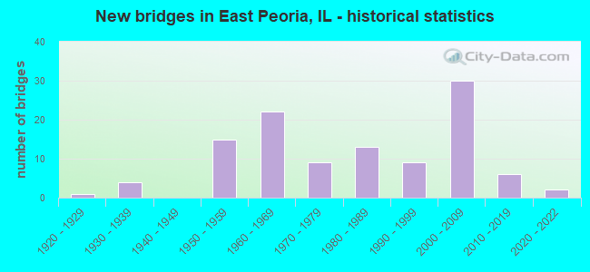
- New bridges - historical statistics
- 11920-1929
- 41930-1939
- 151950-1959
- 221960-1969
- 91970-1979
- 131980-1989
- 91990-1999
- 302000-2009
- 62010-2019
- 22020-2022
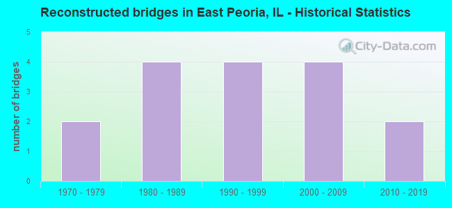
- Reconstructed bridges - Historical Statistics
- 21970-1979
- 41980-1989
- 41990-1999
- 42000-2009
- 22010-2019
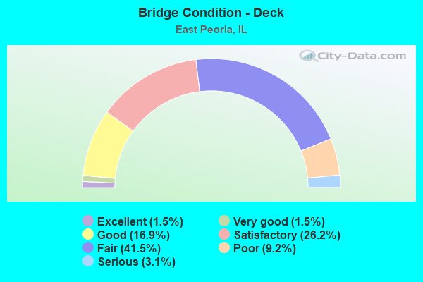
- Bridge Condition - Deck
- 1.5%Excellent
- 1.5%Very good
- 16.9%Good
- 26.2%Satisfactory
- 41.5%Fair
- 9.2%Poor
- 3.1%Serious
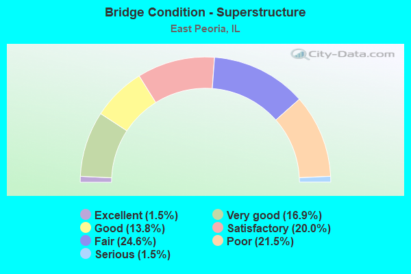
- Bridge Condition - Superstructure
- 1.5%Excellent
- 16.9%Very good
- 13.8%Good
- 20.0%Satisfactory
- 24.6%Fair
- 21.5%Poor
- 1.5%Serious
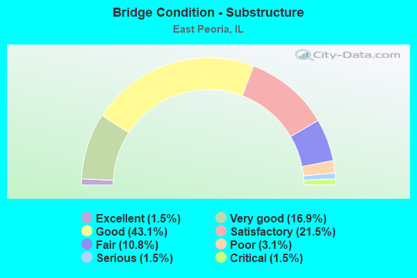
- Bridge Condition - Substructure
- 1.5%Excellent
- 16.9%Very good
- 43.1%Good
- 21.5%Satisfactory
- 10.8%Fair
- 3.1%Poor
- 1.5%Serious
- 1.5%Critical
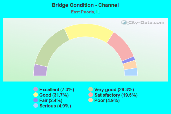
- Bridge Condition - Channel
- 7.3%Excellent
- 29.3%Very good
- 31.7%Good
- 19.5%Satisfactory
- 2.4%Fair
- 4.9%Poor
- 4.9%Serious
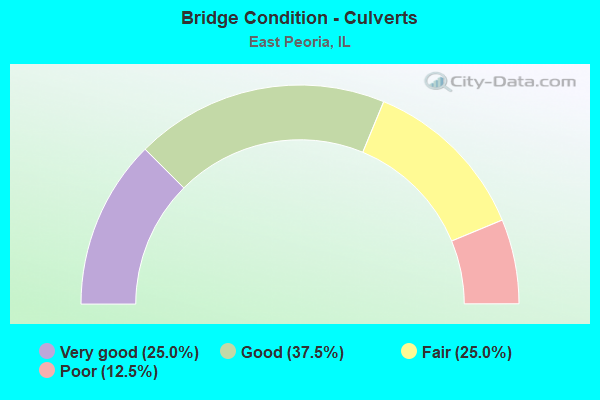
- Bridge Condition - Culverts
- 25.0%Very good
- 37.5%Good
- 25.0%Fair
- 12.5%Poor
Find on map >> Show street view
Structure Number: 900153, Location: EAST PEORIA (Lat: 40.679772, Lng: -89.580025), Route carried "on" structure: Other road , Year Built: 2004, Status: Open, Structure Length: 44.34m (145.47ft), Average Daily Traffic: 2,600 (year 2021), Truck Traffic: 13%, Average Future Daily Traffic: 4,408 (year 2032), Design Load: HS 20, Features Intersected: RMPS H-1,4 DIVR CHAN, Facility Carried by Structure: I74 RP 1.05(H-3)
Minimum Vertical Clearance: 30.40m (99.74ft), Kilometerpoint: 0.483, Lanes on structure: 2, Lanes under structure: 5, Base Highway Network: Yes (Inventory Route: 10074040, Subroute: 50), Owner: State Highway Agency, Approaching Roadway Width: 10.8m (35.4ft), Material/Design: Steel continuous, Design/Construction: Stringer/Multi-beam, Number Of Spans In Main Unit: 8, Length of Maximum Span: 71.7m (235.2ft), Curb-To-Curb Width: 10.8m (35.4ft), Out-to-Out Width: 11.9m (39.0ft)
Condition: Deck: Fair, Superstructure: Satisfactory, Substructure: Good, Channel: Good, Operating Rating: 73.2 metric tons, Method Used To Determine Operating Rating: Load Factor (LF) rating reported by rating factor (RF) method using MS18 loading, Inventory Rating: 44.1 metric tons, Method Used To Determine Inventory Rating: Load Factor (LF) rating reported by rating factor (RF) method using MS18 loading, Structural Evaluation: Equal to present minimum criteria, Deck Geometry: Meets minimum limits, Underclear: Better than present minimum criteria, Waterway Adequacy: Superior to present desirable criteria, Approach Roadway Alignment: Equal to present minimum criteria, Designated Inspection Frequency: Every 24 months, Inspection Date: April 2021, Deck Structure Type: Concrete Cast-file-Place, Wearing Surface/Protective System: Deck Protection: Epoxy Coated Reinforcing
Find on map >> Show street view
Structure Number: 900155, Location: 0.03 MI W OF US 116 (Lat: 40.670592, Lng: -89.574275), Route carried "on" structure: Other road , Year Built: 2005, Status: Open, Structure Length: 19.46m (63.85ft), Average Daily Traffic: 4,700 (year 2018), Truck Traffic: 5%, Average Future Daily Traffic: 4,408 (year 2032), Design Load: HS 20, Features Intersected: MAIN ST & RAMP 1.71, Facility Carried by Structure: 74EB TO EB CAMP ST
Minimum Vertical Clearance: 30+ m (98+ ft), Kilometerpoint: 0.241, Lanes on structure: 1, Lanes under structure: 8, Base Highway Network: Yes (Inventory Route: 10074040, Subroute: 70), Owner: State Highway Agency, Approaching Roadway Width: 10.3m (33.8ft), Material/Design: Prestressed concrete continuous, Design/Construction: Stringer/Multi-beam, Number Of Spans In Main Unit: 6, Length of Maximum Span: 42.1m (138.1ft), Curb-To-Curb Width: 7.9m (25.9ft), Out-to-Out Width: 8.9m (29.2ft)
Condition: Deck: Fair, Superstructure: Satisfactory, Substructure: Good, Operating Rating: 74.2 metric tons, Method Used To Determine Operating Rating: Load Factor (LF) rating reported by rating factor (RF) method using MS18 loading, Inventory Rating: 44.7 metric tons, Method Used To Determine Inventory Rating: Load Factor (LF) rating reported by rating factor (RF) method using MS18 loading, Structural Evaluation: Equal to present minimum criteria, Deck Geometry: High priority of corrective action, Underclear: Somewhat better than minimum adequacy, Approach Roadway Alignment: Equal to present desirable criteria, Designated Inspection Frequency: Every 24 months, Inspection Date: April 2020, Deck Structure Type: Concrete Cast-file-Place, Wearing Surface/Protective System: Deck Protection: Epoxy Coated Reinforcing
Find on map >> Show street view
Structure Number: 900156, Location: 0.02 MI NE 74 (Lat: 40.669814, Lng: -89.572911), Route carried "on" structure: Other road , Year Built: 2006, Status: Open, Structure Length: 21.03m (69.00ft), Average Daily Traffic: 5,200 (year 2018), Truck Traffic: 5%, Average Future Daily Traffic: 5,590 (year 2032), Design Load: HS 20, Features Intersected: MAINST&WB74TONBSB116, Facility Carried by Structure: CAMP ST TO WB 74
Minimum Vertical Clearance: 30+ m (98+ ft), Kilometerpoint: 0.595, Lanes on structure: 1, Lanes under structure: 9, Base Highway Network: Yes (Inventory Route: 10074040, Subroute: 40), Owner: State Highway Agency, Approaching Roadway Width: 7.9m (25.9ft), Material/Design: Steel continuous, Design/Construction: Stringer/Multi-beam, Number Of Spans In Main Unit: 5, Length of Maximum Span: 57.5m (188.6ft), Curb-To-Curb Width: 7.9m (25.9ft), Out-to-Out Width: 8.9m (29.2ft)
Condition: Deck: Satisfactory, Superstructure: Satisfactory, Substructure: Good, Operating Rating: 66.1 metric tons, Method Used To Determine Operating Rating: Load Factor (LF) rating reported by rating factor (RF) method using MS18 loading, Inventory Rating: 39.9 metric tons, Method Used To Determine Inventory Rating: Load Factor (LF) rating reported by rating factor (RF) method using MS18 loading, Structural Evaluation: Equal to present minimum criteria, Deck Geometry: High priority of corrective action, Underclear: High priority of corrective action, Approach Roadway Alignment: Equal to present minimum criteria, Designated Inspection Frequency: Every 24 months, Inspection Date: April 2021, Deck Structure Type: Concrete Cast-file-Place, Wearing Surface/Protective System: Deck Protection: Epoxy Coated Reinforcing
Find on map >> Show street view
Structure Number: 900157, Location: .25 MI E JCT US 116 (Lat: 40.666817, Lng: -89.572053), Route carried "on" structure: Other road , Year Built: 2005, Status: Open, Structure Length: 5.84m (19.16ft), Average Daily Traffic: 4,700 (year 2018), Truck Traffic: 5%, Average Future Daily Traffic: 4,408 (year 2032), Design Load: HS 20+Mod, Features Intersected: WB US 150, Facility Carried by Structure: EXIT TO CAMP ST
Minimum Vertical Clearance: 30+ m (98+ ft), Kilometerpoint: 0.708, Lanes on structure: 1, Lanes under structure: 1, Base Highway Network: Yes (Inventory Route: 10074040, Subroute: 70), Owner: State Highway Agency, Approaching Roadway Width: 8.5m (27.9ft), Skew: 4 degrees, Material/Design: Steel, Design/Construction: Stringer/Multi-beam, Number Of Spans In Main Unit: 3, Number Of Approach Spans: 2, Length of Maximum Span: 22.6m (74.1ft), Curb-To-Curb Width: 8.5m (27.9ft), Out-to-Out Width: 8.9m (29.2ft)
Condition: Deck: Fair, Superstructure: Satisfactory, Substructure: Satisfactory, Operating Rating: 70.3 metric tons, Method Used To Determine Operating Rating: Load Factor (LF) rating reported by rating factor (RF) method using MS18 loading, Inventory Rating: 43.7 metric tons, Method Used To Determine Inventory Rating: Load Factor (LF) rating reported by rating factor (RF) method using MS18 loading, Structural Evaluation: Equal to present minimum criteria, Deck Geometry: Meets minimum limits, Underclear: Equal to present minimum criteria, Approach Roadway Alignment: Equal to present minimum criteria, Designated Inspection Frequency: Every 24 months, Inspection Date: April 2020, Deck Structure Type: Concrete Cast-file-Place, Wearing Surface/Protective System: Deck Protection: Epoxy Coated Reinforcing
Find on map >> Show street view
Structure Number: 900158, Location: .25 MI W OF ILL 116 (Lat: 40.672242, Lng: -89.575225), Route carried "on" structure: Interstate 74, Year Built: 2005, Status: Open, Structure Length: 5.85m (19.19ft), Average Daily Traffic: 52,100 (year 2021), Truck Traffic: 7%, Average Future Daily Traffic: 64,285 (year 2032), Design Load: HS 20+Mod, Features Intersected: ALTORFER LA&TP&W RR
Minimum Vertical Clearance: 30+ m (98+ ft), Kilometerpoint: 155.539, Lanes on structure: 5, Base Highway Network: Yes, Owner: State Highway Agency, Approaching Roadway Width: 29.1m (95.5ft), Material/Design: Prestressed concrete continuous, Design/Construction: Stringer/Multi-beam, Number Of Spans In Main Unit: 3, Length of Maximum Span: 25.7m (84.3ft), Curb-To-Curb Width: 29.1m (95.5ft), Out-to-Out Width: 30.0m (98.4ft)
Condition: Deck: Satisfactory, Superstructure: Very good, Substructure: Good, Operating Rating: 85.5 metric tons, Method Used To Determine Operating Rating: Load Factor (LF) rating reported by rating factor (RF) method using MS18 loading, Inventory Rating: 53.1 metric tons, Method Used To Determine Inventory Rating: Load Factor (LF) rating reported by rating factor (RF) method using MS18 loading, Structural Evaluation: Better than present minimum criteria, Deck Geometry: Superior to present desirable criteria, Underclear: Better than present minimum criteria, Approach Roadway Alignment: Equal to present minimum criteria, Designated Inspection Frequency: Every 24 months, Inspection Date: April 2021, Deck Structure Type: Concrete Cast-file-Place, Wearing Surface/Protective System: Deck Protection: Epoxy Coated Reinforcing
Find on map >> Show street view
Structure Number: 900159, Location: .25 MI W OF ILL 116 (Lat: 40.672158, Lng: -89.575164), Route carried "on" structure: Interstate 74, Year Built: 2006, Status: Open, Structure Length: 5.85m (19.19ft), Average Daily Traffic: 26,050 (year 2021), Truck Traffic: 7%, Average Future Daily Traffic: 32,143 (year 2032), Design Load: HS 20+Mod, Features Intersected: ALTORFER LA&TP&W RR
Minimum Vertical Clearance: 30+ m (98+ ft), Kilometerpoint: 155.555, Lanes on structure: 3, Lanes under structure: 2, Base Highway Network: Yes, Owner: State Highway Agency, Approaching Roadway Width: 23.9m (78.4ft), Material/Design: Prestressed concrete continuous, Design/Construction: Stringer/Multi-beam, Number Of Spans In Main Unit: 3, Length of Maximum Span: 25.7m (84.3ft), Curb-To-Curb Width: 23.9m (78.4ft), Out-to-Out Width: 24.5m (80.4ft)
Condition: Deck: Satisfactory, Superstructure: Very good, Substructure: Good, Operating Rating: 77.4 metric tons, Method Used To Determine Operating Rating: Load Factor (LF) rating reported by rating factor (RF) method using MS18 loading, Inventory Rating: 48.3 metric tons, Method Used To Determine Inventory Rating: Load Factor (LF) rating reported by rating factor (RF) method using MS18 loading, Structural Evaluation: Better than present minimum criteria, Deck Geometry: Superior to present desirable criteria, Underclear: High priority of corrective action, Approach Roadway Alignment: Equal to present minimum criteria, Designated Inspection Frequency: Every 24 months, Inspection Date: April 2021, Deck Structure Type: Concrete Cast-file-Place, Wearing Surface/Protective System: Deck Protection: Epoxy Coated Reinforcing
Find on map >> Show street view
Structure Number: 90016, Location: ILL 116 INTERCHANGE (Lat: 40.670308, Lng: -89.573786), Route carried "on" structure: Interstate 74, Year Built: 2006, Status: Open, Structure Length: 5.90m (19.36ft), Average Daily Traffic: 18,650 (year 2021), Truck Traffic: 10%, Average Future Daily Traffic: 22,683 (year 2032), Design Load: HS 20, Features Intersected: ILL 116 (MAIN ST)
Minimum Vertical Clearance: 30+ m (98+ ft), Kilometerpoint: 155.909, Lanes on structure: 2, Lanes under structure: 8, Base Highway Network: Yes, Owner: State Highway Agency, Approaching Roadway Width: 12.4m (40.7ft), Material/Design: Prestressed concrete, Design/Construction: Stringer/Multi-beam, Number Of Spans In Main Unit: 2, Length of Maximum Span: 29.5m (96.8ft), Curb-To-Curb Width: 11.9m (39.0ft), Out-to-Out Width: 12.4m (40.7ft)
Condition: Deck: Fair, Superstructure: Good, Substructure: Very good, Operating Rating: 72.3 metric tons, Method Used To Determine Operating Rating: Load Factor (LF) rating reported by rating factor (RF) method using MS18 loading, Inventory Rating: 44.4 metric tons, Method Used To Determine Inventory Rating: Load Factor (LF) rating reported by rating factor (RF) method using MS18 loading, Structural Evaluation: Better than present minimum criteria, Deck Geometry: Equal to present minimum criteria, Underclear: High priority of corrective action, Approach Roadway Alignment: Equal to present desirable criteria, Designated Inspection Frequency: Every 24 months, Inspection Date: June 2021, Deck Structure Type: Concrete Cast-file-Place, Wearing Surface/Protective System: Deck Protection: Epoxy Coated Reinforcing
Find on map >> Show street view
Structure Number: 900161, Location: ILL 116 INTERCHANGE (Lat: 40.670200, Lng: -89.573708), Route carried "on" structure: Interstate 74, Year Built: 2005, Status: Open, Structure Length: 5.90m (19.36ft), Average Daily Traffic: 37,300 (year 2021), Truck Traffic: 10%, Average Future Daily Traffic: 45,365 (year 2032), Design Load: HS 20+Mod, Features Intersected: ILL 116(MAIN ST)
Minimum Vertical Clearance: 30+ m (98+ ft), Kilometerpoint: 155.925, Lanes on structure: 4, Lanes under structure: 8, Base Highway Network: Yes, Owner: State Highway Agency, Approaching Roadway Width: 16.9m (55.4ft), Material/Design: Prestressed concrete continuous, Design/Construction: Stringer/Multi-beam, Number Of Spans In Main Unit: 2, Length of Maximum Span: 29.1m (95.5ft), Curb-To-Curb Width: 16.9m (55.4ft), Out-to-Out Width: 19.6m (64.3ft)
Condition: Deck: Fair, Superstructure: Very good, Substructure: Very good, Operating Rating: 68.4 metric tons, Method Used To Determine Operating Rating: Load Factor (LF) rating reported by rating factor (RF) method using MS18 loading, Inventory Rating: 46.0 metric tons, Method Used To Determine Inventory Rating: Load Factor (LF) rating reported by rating factor (RF) method using MS18 loading, Structural Evaluation: Equal to present desirable criteria, Deck Geometry: High priority of replacement, Underclear: High priority of corrective action, Approach Roadway Alignment: Equal to present desirable criteria, Designated Inspection Frequency: Every 24 months, Inspection Date: April 2020, Deck Structure Type: Concrete Cast-file-Place, Wearing Surface/Protective System: Deck Protection: Epoxy Coated Reinforcing
Find on map >> Show street view
Structure Number: 900162, Location: ILL 8 INTER,E PEORIA (Lat: 40.663875, Lng: -89.569097), Route carried "on" structure: Interstate 74, Year Built: 2005, Status: Open, Structure Length: 6.40m (21.00ft), Average Daily Traffic: 19,150 (year 2021), Truck Traffic: 11%, Average Future Daily Traffic: 22,360 (year 2032), Design Load: HS 20+Mod, Features Intersected: E WASHINGTON, TAYLOR
Minimum Vertical Clearance: 30+ m (98+ ft), Kilometerpoint: 156.714, Lanes on structure: 3, Lanes under structure: 8, Base Highway Network: Yes, Owner: State Highway Agency, Approaching Roadway Width: 16.9m (55.4ft), Material/Design: Prestressed concrete continuous, Design/Construction: Stringer/Multi-beam, Number Of Spans In Main Unit: 2, Length of Maximum Span: 34.8m (114.2ft), Curb-To-Curb Width: 16.9m (55.4ft), Out-to-Out Width: 20.4m (66.9ft)
Condition: Deck: Fair, Superstructure: Satisfactory, Substructure: Good, Operating Rating: 64.5 metric tons, Method Used To Determine Operating Rating: Load Factor (LF) rating reported by rating factor (RF) method using MS18 loading, Inventory Rating: 40.5 metric tons, Method Used To Determine Inventory Rating: Load Factor (LF) rating reported by rating factor (RF) method using MS18 loading, Structural Evaluation: Equal to present minimum criteria, Deck Geometry: Equal to present minimum criteria, Underclear: High priority of corrective action, Approach Roadway Alignment: Equal to present minimum criteria, Designated Inspection Frequency: Every 24 months, Inspection Date: April 2021, Deck Structure Type: Concrete Cast-file-Place, Wearing Surface/Protective System: Deck Protection: Epoxy Coated Reinforcing
Find on map >> Show street view
Structure Number: 900163, Location: ILL 8 INTER,E PEORIA (Lat: 40.663772, Lng: -89.569031), Route carried "on" structure: Interstate 74, Year Built: 2006, Status: Open, Structure Length: 6.40m (21.00ft), Average Daily Traffic: 19,150 (year 2021), Truck Traffic: 11%, Average Future Daily Traffic: 22,360 (year 2032), Design Load: HS 20+Mod, Features Intersected: E WASHINGTON, TAYLOR
Minimum Vertical Clearance: 30+ m (98+ ft), Kilometerpoint: 156.730, Lanes on structure: 3, Lanes under structure: 6, Base Highway Network: Yes, Owner: State Highway Agency, Approaching Roadway Width: 14.8m (48.6ft), Material/Design: Prestressed concrete continuous, Design/Construction: Stringer/Multi-beam, Number Of Spans In Main Unit: 2, Length of Maximum Span: 35.1m (115.2ft), Curb-To-Curb Width: 14.8m (48.6ft), Out-to-Out Width: 15.3m (50.2ft)
Condition: Deck: Satisfactory, Superstructure: Good, Substructure: Good, Operating Rating: 60.6 metric tons, Method Used To Determine Operating Rating: Load Factor (LF) rating reported by rating factor (RF) method using MS18 loading, Inventory Rating: 38.2 metric tons, Method Used To Determine Inventory Rating: Load Factor (LF) rating reported by rating factor (RF) method using MS18 loading, Structural Evaluation: Better than present minimum criteria, Deck Geometry: Meets minimum limits, Underclear: High priority of corrective action, Approach Roadway Alignment: Equal to present minimum criteria, Designated Inspection Frequency: Every 24 months, Inspection Date: April 2021, Deck Structure Type: Concrete Cast-file-Place, Wearing Surface/Protective System: Deck Protection: Epoxy Coated Reinforcing
Find on map >> Show street view
Structure Number: 900164, Location: US 150 E PEORIA (Lat: 40.665283, Lng: -89.540997), Route carried "on" structure: US 150, Year Built: 1998, Status: Open, Structure Length: 2.31m (7.58ft), Average Daily Traffic: 6,150 (year 2021), Truck Traffic: 3%, Average Future Daily Traffic: 7,310 (year 2032), Design Load: HS 20, Features Intersected: LITTLE FARM CREEK, Facility Carried by Structure: MEADOWS AVE
Minimum Vertical Clearance: 30+ m (98+ ft), Kilometerpoint: 155.603, Lanes on structure: 4, Base Highway Network: Yes, Owner: State Highway Agency, Approaching Roadway Width: 18.0m (59.1ft), Skew: 2 degrees, Material/Design: Steel, Design/Construction: Stringer/Multi-beam, Number Of Spans In Main Unit: 1, Length of Maximum Span: 22.3m (73.2ft), Curb-To-Curb Width: 18.0m (59.1ft), Out-to-Out Width: 19.0m (62.3ft)
Condition: Deck: Satisfactory, Superstructure: Good, Substructure: Good, Channel: Good, Operating Rating: 72.9 metric tons, Method Used To Determine Operating Rating: Load Factor (LF) rating reported by rating factor (RF) method using MS18 loading, Inventory Rating: 43.7 metric tons, Method Used To Determine Inventory Rating: Load Factor (LF) rating reported by rating factor (RF) method using MS18 loading, Structural Evaluation: Better than present minimum criteria, Deck Geometry: Somewhat better than minimum adequacy, Waterway Adequacy: Superior to present desirable criteria, Approach Roadway Alignment: Equal to present minimum criteria, Designated Inspection Frequency: Every 48 months, Inspection Date: November 2020, Deck Structure Type: Concrete Cast-file-Place, Wearing Surface/Protective System: Deck Protection: Epoxy Coated Reinforcing
Find on map >> Show street view
Structure Number: 900171, Location: N OF ILL 116 (Lat: 40.735953, Lng: -89.521864), Route carried "on" structure: State highway 26, Year Built: 2004, Status: Open, Structure Length: 3.83m (12.57ft), Average Daily Traffic: 6,000 (year 2021), Truck Traffic: 9%, Average Future Daily Traffic: 8,009 (year 2032), Design Load: HS 20, Features Intersected: TEN MILE CREEK
Minimum Vertical Clearance: 30+ m (98+ ft), Kilometerpoint: 0.676, Lanes on structure: 2, Base Highway Network: Yes, Owner: State Highway Agency, Approaching Roadway Width: 12.2m (40.0ft), Material/Design: Steel continuous, Design/Construction: Stringer/Multi-beam, Number Of Spans In Main Unit: 3, Length of Maximum Span: 19.1m (62.7ft), Curb-To-Curb Width: 12.2m (40.0ft), Out-to-Out Width: 13.2m (43.3ft)
Condition: Deck: Fair, Superstructure: Fair, Substructure: Good, Channel: Satisfactory, Operating Rating: 85.2 metric tons, Method Used To Determine Operating Rating: Load Factor (LF) rating reported by rating factor (RF) method using MS18 loading, Inventory Rating: 51.2 metric tons, Method Used To Determine Inventory Rating: Load Factor (LF) rating reported by rating factor (RF) method using MS18 loading, Structural Evaluation: Somewhat better than minimum adequacy, Deck Geometry: Somewhat better than minimum adequacy, Waterway Adequacy: Equal to present desirable criteria, Approach Roadway Alignment: Equal to present desirable criteria, Designated Inspection Frequency: Every 24 months, Inspection Date: December 2020, Deck Structure Type: Concrete Cast-file-Place, Wearing Surface/Protective System: Deck Protection: Epoxy Coated Reinforcing
Find on map >> Show street view
Structure Number: 900173, Location: 2.5 MI W OF MORTON (Lat: 40.604603, Lng: -89.565422), Route carried "on" structure: State highway 98, Year Built: 2007, Status: Open, Structure Length: 2.68m (8.79ft), Average Daily Traffic: 3,400 (year 2021), Truck Traffic: 5%, Average Future Daily Traffic: 4,246 (year 2032), Design Load: HS 25 or greater, Features Intersected: LICK CREEK
Minimum Vertical Clearance: 30+ m (98+ ft), Kilometerpoint: 6.051, Lanes on structure: 2, Base Highway Network: Yes, Owner: State Highway Agency, Approaching Roadway Width: 11.0m (36.1ft), Material/Design: Prestressed concrete, Design/Construction: Stringer/Multi-beam, Number Of Spans In Main Unit: 1, Length of Maximum Span: 26.0m (85.3ft), Curb-To-Curb Width: 11.0m (36.1ft), Out-to-Out Width: 11.9m (39.0ft)
Condition: Deck: Good, Superstructure: Very good, Substructure: Good, Channel: Satisfactory, Operating Rating: 83.9 metric tons, Method Used To Determine Operating Rating: Load Factor (LF) rating reported by rating factor (RF) method using MS18 loading, Inventory Rating: 52.5 metric tons, Method Used To Determine Inventory Rating: Load Factor (LF) rating reported by rating factor (RF) method using MS18 loading, Structural Evaluation: Better than present minimum criteria, Deck Geometry: Somewhat better than minimum adequacy, Waterway Adequacy: Superior to present desirable criteria, Approach Roadway Alignment: Equal to present minimum criteria, Designated Inspection Frequency: Every 48 months, Inspection Date: September 2021, Deck Structure Type: Concrete Cast-file-Place, Wearing Surface/Protective System: Deck Protection: Epoxy Coated Reinforcing
Find on map >> Show street view
Structure Number: 900175, Location: MEADOWS AVE E. PEO. (Lat: 40.666100, Lng: -89.550961), Route carried "on" structure: US 150, Year Built: 2010, Status: Open, Structure Length: 2.13m (6.99ft), Average Daily Traffic: 8,350 (year 2021), Truck Traffic: 6%, Average Future Daily Traffic: 8,923 (year 2032), Design Load: HS 20, Features Intersected: LITTLE FARM CREEK
Minimum Vertical Clearance: 30+ m (98+ ft), Kilometerpoint: 154.750, Lanes on structure: 2, Base Highway Network: Yes, Owner: State Highway Agency, Approaching Roadway Width: 11.0m (36.1ft), Skew: 3 degrees, Material/Design: Concrete, Design/Construction: Slab, Number Of Spans In Main Unit: 1, Length of Maximum Span: 20.6m (67.6ft), Curb-To-Curb Width: 12.2m (40.0ft), Out-to-Out Width: 26.5m (86.9ft)
Condition: Deck: Satisfactory, Superstructure: Satisfactory, Substructure: Good, Channel: Good, Operating Rating: 89.1 metric tons, Method Used To Determine Operating Rating: Load Factor (LF) rating reported by rating factor (RF) method using MS18 loading, Inventory Rating: 65.8 metric tons, Method Used To Determine Inventory Rating: Load Factor (LF) rating reported by rating factor (RF) method using MS18 loading, Structural Evaluation: Equal to present minimum criteria, Deck Geometry: Somewhat better than minimum adequacy, Waterway Adequacy: Superior to present desirable criteria, Approach Roadway Alignment: Equal to present desirable criteria, Designated Inspection Frequency: Every 24 months, Inspection Date: December 2020, Deck Structure Type: Concrete Cast-file-Place, Wearing Surface/Protective System: Wearing Surface: Other, Deck Protection: Epoxy Coated Reinforcing
Find on map >> Show street view
Structure Number: 900176, Location: 1.7 MI E OF ILL 8 (Lat: 40.662789, Lng: -89.532161), Route carried "on" structure: US 150, Year Built: 2009, Status: Open, Structure Length: 1.92m (6.30ft), Average Daily Traffic: 5,900 (year 2021), Truck Traffic: 5%, Average Future Daily Traffic: 6,934 (year 2032), Design Load: HS 20, Features Intersected: LITTLE FARM CREEK
Minimum Vertical Clearance: 30+ m (98+ ft), Kilometerpoint: 156.408, Lanes on structure: 2, Base Highway Network: Yes, Owner: State Highway Agency, Approaching Roadway Width: 17.1m (56.1ft), Skew: 1 degrees, Material/Design: Prestressed concrete, Design/Construction: Stringer/Multi-beam, Number Of Spans In Main Unit: 1, Length of Maximum Span: 18.4m (60.4ft), Curb or Sidewalk Widths: Left: 0.0m, Right: 2.1m (6.9ft), Curb-To-Curb Width: 15.0m (49.2ft), Out-to-Out Width: 18.3m (60.0ft)
Condition: Deck: Fair, Superstructure: Very good, Substructure: Good, Channel: Good, Operating Rating: 80.4 metric tons, Method Used To Determine Operating Rating: Load Factor (LF) rating reported by rating factor (RF) method using MS18 loading, Inventory Rating: 48.3 metric tons, Method Used To Determine Inventory Rating: Load Factor (LF) rating reported by rating factor (RF) method using MS18 loading, Structural Evaluation: Better than present minimum criteria, Deck Geometry: Superior to present desirable criteria, Waterway Adequacy: Superior to present desirable criteria, Approach Roadway Alignment: Equal to present desirable criteria, Designated Inspection Frequency: Every 24 months, Inspection Date: December 2020, Deck Structure Type: Concrete Cast-file-Place, Wearing Surface/Protective System: Deck Protection: Epoxy Coated Reinforcing
Find on map >> Show street view
Structure Number: 900179, Location: N OF ILL 26 (Lat: 40.738244, Lng: -89.515894), Route carried "on" structure: State highway 116, Year Built: 2014, Status: Open, Structure Length: 5.57m (18.27ft), Average Daily Traffic: 14,900 (year 2021), Truck Traffic: 4%, Average Future Daily Traffic: 10,000 (year 2032), Design Load: HS 25 or greater, Features Intersected: TEN MILE CREEK
Minimum Vertical Clearance: 30+ m (98+ ft), Kilometerpoint: 138.384, Lanes on structure: 2, Base Highway Network: Yes, Owner: State Highway Agency, Approaching Roadway Width: 12.2m (40.0ft), Skew: 3 degrees, Material/Design: Steel continuous, Design/Construction: Stringer/Multi-beam, Number Of Spans In Main Unit: 2, Length of Maximum Span: 33.8m (110.9ft), Curb-To-Curb Width: 12.2m (40.0ft), Out-to-Out Width: 13.2m (43.3ft)
Condition: Deck: Fair, Superstructure: Good, Substructure: Very good, Channel: Very good, Operating Rating: 57.3 metric tons, Method Used To Determine Operating Rating: Load and Resistance Factor Rating (LRFR) rating reported by rating factor(RF) method using HL-93 loadings, Inventory Rating: 44.1 metric tons, Method Used To Determine Inventory Rating: Load and Resistance Factor Rating (LRFR) rating reported by rating factor(RF) method using HL-93 loadings, Structural Evaluation: Better than present minimum criteria, Deck Geometry: Better than present minimum criteria, Waterway Adequacy: Superior to present desirable criteria, Approach Roadway Alignment: Equal to present desirable criteria, Designated Inspection Frequency: Every 24 months, Inspection Date: Febuary 2021, Deck Structure Type: Concrete Cast-file-Place, Wearing Surface/Protective System: Deck Protection: Epoxy Coated Reinforcing
Find on map >> Show street view
Structure Number: 900181, Location: PINECREST DR. (Lat: 40.643283, Lng: -89.540497), Route carried "on" structure: Other road , Year Built: 2021, Status: Open, Structure Length: 6.53m (21.42ft), Average Daily Traffic: 5,100 (year 2018), Truck Traffic: 10%, Average Future Daily Traffic: 5,214 (year 2032), Design Load: HS 25 or greater, Features Intersected: I-74, Facility Carried by Structure: PINECREST DR.
Minimum Vertical Clearance: 30+ m (98+ ft), Kilometerpoint: 2.543, Lanes on structure: 3, Lanes under structure: 4, Base Highway Network: Yes, Owner: State Highway Agency, Approaching Roadway Width: 11.0m (36.1ft), Skew: 31 degrees, Material/Design: Steel continuous, Design/Construction: Stringer/Multi-beam, Number Of Spans In Main Unit: 2, Length of Maximum Span: 0.0m, Curb or Sidewalk Widths: Left: 0.0m, Right: 3.0m (9.8ft), Curb-To-Curb Width: 17.7m (58.1ft), Out-to-Out Width: 23.1m (75.8ft)
Condition: Deck: Excellent, Superstructure: Excellent, Substructure: Excellent, Operating Rating: 60.6 metric tons, Method Used To Determine Operating Rating: Load and Resistance Factor Rating (LRFR) rating reported by rating factor(RF) method using HL-93 loadings, Inventory Rating: 46.7 metric tons, Method Used To Determine Inventory Rating: Load and Resistance Factor Rating (LRFR) rating reported by rating factor(RF) method using HL-93 loadings, Structural Evaluation: Superior to present desirable criteria, Deck Geometry: Superior to present desirable criteria, Underclear: High priority of corrective action, Approach Roadway Alignment: Equal to present desirable criteria, Designated Inspection Frequency: Every 24 months, Inspection Date: September 2021, Deck Structure Type: Concrete Cast-file-Place, Wearing Surface/Protective System: Deck Protection: Epoxy Coated Reinforcing
Find on map >> Show street view
Structure Number: 902001, Location: SW-33-T26NR4W (Lat: 40.664650, Lng: -89.577428), Route carried "on" structure: Other road , Year Built: 1953, Status: Open, Structure Length: 0.67m (2.20ft), Average Daily Traffic: 5,175 (year 2018), Truck Traffic: 5%, Average Future Daily Traffic: 6,074 (year 2032), Design Load: HS 20, Features Intersected: COLE CREEK, Facility Carried by Structure: WASHINGTON ST
Minimum Vertical Clearance: 30+ m (98+ ft), Kilometerpoint: 1.320, Lanes on structure: 2, Base Highway Network: Yes, Owner: City or Municipal Highway Agency, Approaching Roadway Width: 12.2m (40.0ft), Skew: 4 degrees, Material/Design: Concrete, Design/Construction: Culvert, Number Of Spans In Main Unit: 1, Length of Maximum Span: 6.7m (22.0ft), Curb or Sidewalk Widths: Left: 2.8m (9.2ft), Right: 2.8m (9.2ft), Curb-To-Curb Width: 12.3m (40.4ft), Out-to-Out Width: 18.8m (61.7ft)
Condition: Channel: Very good, Culverts: Very good, Operating Rating: 53.8 metric tons, Method Used To Determine Operating Rating: Field evaluation and documented engineering judgment, Inventory Rating: 32.4 metric tons, Method Used To Determine Inventory Rating: Field evaluation and documented engineering judgment, Structural Evaluation: Equal to present desirable criteria, Deck Geometry: Somewhat better than minimum adequacy, Waterway Adequacy: Equal to present desirable criteria, Approach Roadway Alignment: Equal to present minimum criteria, Designated Inspection Frequency: Every 24 months, Inspection Date: April 2020
Find on map >> Show street view
Structure Number: 902006, Location: .1M S JCT US 150&116 (Lat: 40.713342, Lng: -89.530450), Route carried "on" structure: US 24, Year Built: 1964, Status: Open, Structure Length: 0.70m (2.30ft), Average Daily Traffic: 20,400 (year 2021), Truck Traffic: 8%, Average Future Daily Traffic: 26,660 (year 2032), Design Load: HS 20, Features Intersected: IL RIVER TRIBUTARY, Facility Carried by Structure: US 150 & ILL 116
Minimum Vertical Clearance: 30+ m (98+ ft), Kilometerpoint: 218.768, Lanes on structure: 4, Base Highway Network: Yes, Owner: State Highway Agency, Approaching Roadway Width: 20.7m (67.9ft), Skew: 12 degrees, Material/Design: Concrete continuous, Design/Construction: Culvert, Number Of Spans In Main Unit: 2, Length of Maximum Span: 3.4m (11.2ft)
Condition: Channel: Fair, Culverts: Poor, Operating Rating: 58.3 metric tons, Method Used To Determine Operating Rating: Load Factor (LF) rating reported by rating factor (RF) method using MS18 loading, Inventory Rating: 35.0 metric tons, Method Used To Determine Inventory Rating: Load Factor (LF) rating reported by rating factor (RF) method using MS18 loading, Structural Evaluation: Meets minimum limits, Waterway Adequacy: Superior to present desirable criteria, Approach Roadway Alignment: Equal to present desirable criteria, Designated Inspection Frequency: Every 12 months, Inspection Date: Febuary 2021
Find on map >> Show street view
Structure Number: 902013, Location: SW RAMP MCCLUGAGE (Lat: 40.713417, Lng: -89.531219), Route carried "on" structure: Other road , Year Built: 1993, Status: Open, Structure Length: 0.66m (2.17ft), Average Daily Traffic: 3,700 (year 2018), Truck Traffic: 6%, Average Future Daily Traffic: 4,031 (year 2032), Design Load: HS 20, Features Intersected: IL RIVER TRIB., Facility Carried by Structure: ILL 116 RP #2.64
Minimum Vertical Clearance: 30+ m (98+ ft), Kilometerpoint: 0.467, Lanes on structure: 1, Base Highway Network: Yes (Inventory Route: 20673040, Subroute: 40), Owner: State Highway Agency, Approaching Roadway Width: 9.8m (32.2ft), Skew: 4 degrees, Material/Design: Concrete, Design/Construction: Culvert, Number Of Spans In Main Unit: 2, Length of Maximum Span: 3.0m (9.8ft)
Condition: Channel: Satisfactory, Culverts: Good, Operating Rating: 57.3 metric tons, Method Used To Determine Operating Rating: Load Factor (LF) rating reported by rating factor (RF) method using MS18 loading, Inventory Rating: 34.7 metric tons, Method Used To Determine Inventory Rating: Load Factor (LF) rating reported by rating factor (RF) method using MS18 loading, Structural Evaluation: Better than present minimum criteria, Waterway Adequacy: Equal to present desirable criteria, Approach Roadway Alignment: Equal to present desirable criteria, Designated Inspection Frequency: Every 48 months, Inspection Date: December 2017
Find on map >> Show street view
Structure Number: 902016, Location: E OF CARVER LANE (Lat: 40.676950, Lng: -89.531286), Route carried "on" structure: State highway 8, Year Built: 2003, Status: Open, Structure Length: 0.81m (2.66ft), Average Daily Traffic: 14,700 (year 2021), Truck Traffic: 4%, Average Future Daily Traffic: 16,448 (year 2032), Design Load: HS 20, Features Intersected: BRANCH FARM CREEK
Minimum Vertical Clearance: 30+ m (98+ ft), Kilometerpoint: 61.781, Lanes on structure: 4, Base Highway Network: Yes, Owner: State Highway Agency, Approaching Roadway Width: 18.3m (60.0ft), Skew: 2 degrees, Material/Design: Concrete continuous, Design/Construction: Culvert, Number Of Spans In Main Unit: 2, Length of Maximum Span: 3.9m (12.8ft), Curb or Sidewalk Widths: Left: 2.1m (6.9ft), Right: 2.1m (6.9ft), Curb-To-Curb Width: 19.5m (64.0ft), Out-to-Out Width: 23.0m (75.5ft)
Condition: Channel: Very good, Culverts: Good, Operating Rating: 60.6 metric tons, Method Used To Determine Operating Rating: Load Factor (LF) rating reported by rating factor (RF) method using MS18 loading, Inventory Rating: 36.6 metric tons, Method Used To Determine Inventory Rating: Load Factor (LF) rating reported by rating factor (RF) method using MS18 loading, Structural Evaluation: Better than present minimum criteria, Deck Geometry: Better than present minimum criteria, Waterway Adequacy: Superior to present desirable criteria, Approach Roadway Alignment: Equal to present desirable criteria, Designated Inspection Frequency: Every 48 months, Inspection Date: October 2020
Find on map >> Show street view
Structure Number: 902017, Location: AT ARNOLD RD (Lat: 40.673617, Lng: -89.543636), Route carried "on" structure: State highway 8, Year Built: 1999, Status: Open, Structure Length: 0.72m (2.36ft), Average Daily Traffic: 20,200 (year 2021), Truck Traffic: 6%, Average Future Daily Traffic: 22,360 (year 2032), Design Load: HS 20, Features Intersected: DOLANS CREEK
Minimum Vertical Clearance: 30+ m (98+ ft), Kilometerpoint: 60.671, Lanes on structure: 4, Base Highway Network: Yes, Owner: State Highway Agency, Approaching Roadway Width: 18.0m (59.1ft), Skew: 22 degrees, Material/Design: Concrete, Design/Construction: Culvert, Number Of Spans In Main Unit: 2, Length of Maximum Span: 3.0m (9.8ft)
Condition: Channel: Satisfactory, Culverts: Fair, Operating Rating: 82.0 metric tons, Method Used To Determine Operating Rating: Load Factor (LF) rating reported by rating factor (RF) method using MS18 loading, Inventory Rating: 49.2 metric tons, Method Used To Determine Inventory Rating: Load Factor (LF) rating reported by rating factor (RF) method using MS18 loading, Structural Evaluation: Somewhat better than minimum adequacy, Waterway Adequacy: Equal to present desirable criteria, Approach Roadway Alignment: Equal to present desirable criteria, Designated Inspection Frequency: Every 24 months, Inspection Date: October 2021, Deck Structure Type: Concrete Precast Panels
Find on map >> Show street view
Structure Number: 903193, Location: NE-35-T26NR4W (Lat: 40.673756, Lng: -89.526331), Route carried "on" structure: Other road , Year Built: 1985, Status: Open, Structure Length: 1.34m (4.40ft), Average Daily Traffic: 3,550 (year 2018), Truck Traffic: 6%, Average Future Daily Traffic: 4,999 (year 2032), Design Load: HS 20, Features Intersected: BR OF FARM CREEK, Facility Carried by Structure: FARMDALE RD-FAU 67
Minimum Vertical Clearance: 30+ m (98+ ft), Kilometerpoint: 9.141, Lanes on structure: 2, Owner: City or Municipal Highway Agency, Approaching Roadway Width: 12.2m (40.0ft), Skew: 3 degrees, Material/Design: Prestressed concrete, Design/Construction: Box Beam or Girders - Multiple, Number Of Spans In Main Unit: 1, Length of Maximum Span: 12.6m (41.3ft), Curb-To-Curb Width: 12.2m (40.0ft), Out-to-Out Width: 12.2m (40.0ft)
Condition: Deck: Good, Superstructure: Satisfactory, Substructure: Satisfactory, Channel: Good, Operating Rating: 44.4 metric tons, Method Used To Determine Operating Rating: Assigned rating based on Load Factor Design (LFD) reported by rating factor (RF) using MS18 loading, Inventory Rating: 32.4 metric tons, Method Used To Determine Inventory Rating: Assigned rating based on Load Factor Design (LFD) reported by rating factor (RF) using MS18 loading, Structural Evaluation: Equal to present minimum criteria, Deck Geometry: Equal to present minimum criteria, Waterway Adequacy: Equal to present minimum criteria, Approach Roadway Alignment: Equal to present desirable criteria, Designated Inspection Frequency: Every 24 months, Inspection Date: June 2021, Deck Structure Type: Concrete Precast Panels, Wearing Surface/Protective System: Wearing Surface: Bituminous, Membrane: Built-up
Find on map >> Show street view
Structure Number: 903225, Location: N CTR-35-T26NR4W (Lat: 40.674950, Lng: -89.531886), Route carried "on" structure: Other road , Year Built: 1999, Status: Open, Structure Length: 0.84m (2.76ft), Average Daily Traffic: 3,550 (year 2018), Truck Traffic: 6%, Average Future Daily Traffic: 4,999 (year 2032), Design Load: HS 20, Features Intersected: BRANCH TO FARM CREEK, Facility Carried by Structure: FAU 6775-FARMDALE
Minimum Vertical Clearance: 30+ m (98+ ft), Kilometerpoint: 9.640, Lanes on structure: 2, Owner: City or Municipal Highway Agency, Approaching Roadway Width: 8.5m (27.9ft), Material/Design: Concrete, Design/Construction: Culvert, Number Of Spans In Main Unit: 3, Length of Maximum Span: 2.6m (8.5ft)
Condition: Channel: Good, Culverts: Very good, Operating Rating: 44.1 metric tons, Method Used To Determine Operating Rating: Assigned rating based on Load Factor Design (LFD) reported by rating factor (RF) using MS18 loading, Inventory Rating: 32.4 metric tons, Method Used To Determine Inventory Rating: Assigned rating based on Load Factor Design (LFD) reported by rating factor (RF) using MS18 loading, Structural Evaluation: Equal to present desirable criteria, Waterway Adequacy: Equal to present desirable criteria, Approach Roadway Alignment: Equal to present desirable criteria, Designated Inspection Frequency: Every 48 months, Inspection Date: March 2021, Wearing Surface/Protective System: Wearing Surface: Bituminous
Find on map >> Show street view
Structure Number: 903234, Location: E1/2-SEC36-T26NR4W (Lat: 40.667367, Lng: -89.504736), Route carried "on" structure: County highway , Year Built: 2005, Status: Open, Structure Length: 1.89m (6.20ft), Average Daily Traffic: 725 (year 2018), Truck Traffic: 4%, Average Future Daily Traffic: 806 (year 2032), Design Load: HS 20, Features Intersected: FARM CREEK, Facility Carried by Structure: TR 23(FARMDALE RD)
Minimum Vertical Clearance: 30+ m (98+ ft), Kilometerpoint: 0.241, Lanes on structure: 2, Owner: Town or Township Highway Agency, Approaching Roadway Width: 6.7m (22.0ft), Skew: 3 degrees, Material/Design: Prestressed concrete, Design/Construction: Box Beam or Girders - Multiple, Number Of Spans In Main Unit: 1, Length of Maximum Span: 18.0m (59.1ft), Curb-To-Curb Width: 8.5m (27.9ft), Out-to-Out Width: 8.5m (27.9ft)
Condition: Deck: Good, Superstructure: Good, Substructure: Very good, Channel: Good, Operating Rating: 44.1 metric tons, Method Used To Determine Operating Rating: Assigned rating based on Load Factor Design (LFD) reported by rating factor (RF) using MS18 loading, Inventory Rating: 32.4 metric tons, Method Used To Determine Inventory Rating: Assigned rating based on Load Factor Design (LFD) reported by rating factor (RF) using MS18 loading, Structural Evaluation: Better than present minimum criteria, Deck Geometry: Somewhat better than minimum adequacy, Waterway Adequacy: Better than present minimum criteria, Approach Roadway Alignment: Equal to present desirable criteria, Designated Inspection Frequency: Every 48 months, Inspection Date: December 2020, Deck Structure Type: Concrete Precast Panels
Find on map >> Show street view
Structure Number: 903244, Location: SE-36-T26NR4W (Lat: 40.664711, Lng: -89.508911), Route carried "on" structure: County highway , Year Built: 2012, Status: Open, Structure Length: 3.44m (11.29ft), Average Daily Traffic: 2,450 (year 2018), Truck Traffic: 5%, Average Future Daily Traffic: 2,450 (year 2034), Design Load: HS 25 or greater, Features Intersected: Farm Creek, Facility Carried by Structure: TR 156
Minimum Vertical Clearance: 30+ m (98+ ft), Kilometerpoint: 0.225, Lanes on structure: 2, Owner: Town or Township Highway Agency, Approaching Roadway Width: 12.2m (40.0ft), Material/Design: Steel continuous, Design/Construction: Stringer/Multi-beam, Number Of Spans In Main Unit: 3, Length of Maximum Span: 14.2m (46.6ft), Curb-To-Curb Width: 12.2m (40.0ft), Out-to-Out Width: 13.2m (43.3ft)
Condition: Deck: Good, Superstructure: Very good, Substructure: Very good, Channel: Satisfactory, Operating Rating: 42.1 metric tons, Method Used To Determine Operating Rating: Assigned ratings based on Load and Resistance Factor Design (LRFD) reported by rating factor (RF) using HL93 loadings, Inventory Rating: 32.4 metric tons, Method Used To Determine Inventory Rating: Assigned ratings based on Load and Resistance Factor Design (LRFD) reported by rating factor (RF) using HL93 loadings, Structural Evaluation: Equal to present desirable criteria, Deck Geometry: Equal to present minimum criteria, Waterway Adequacy: Equal to present desirable criteria, Approach Roadway Alignment: Equal to present desirable criteria, Designated Inspection Frequency: Every 48 months, Inspection Date: October 2018, Deck Structure Type: Concrete Cast-file-Place, Wearing Surface/Protective System: Deck Protection: Epoxy Coated Reinforcing
Find on map >> Show street view
Structure Number: 905023, Location: NE-5-T25NR4W (Lat: 40.655378, Lng: -89.575397), Route carried "on" structure: Other road , Year Built: 1954, Status: Open, Structure Length: 0.73m (2.40ft), Average Daily Traffic: 2,200 (year 2018), Truck Traffic: 5%, Average Future Daily Traffic: 2,473 (year 2032), Features Intersected: STREAM, Facility Carried by Structure: FAU 6699
Minimum Vertical Clearance: 30+ m (98+ ft), Kilometerpoint: 1.159, Lanes on structure: 2, Owner: Town or Township Highway Agency, Approaching Roadway Width: 7.0m (23.0ft), Skew: 4 degrees, Material/Design: Concrete, Design/Construction: Culvert, Number Of Spans In Main Unit: 2, Length of Maximum Span: 3.7m (12.1ft)
Condition: Channel: Poor, Culverts: Fair, Operating Rating: 40.5 metric tons, Method Used To Determine Operating Rating: Field evaluation and documented engineering judgment, Inventory Rating: 24.3 metric tons, Method Used To Determine Inventory Rating: Field evaluation and documented engineering judgment, Structural Evaluation: Somewhat better than minimum adequacy, Waterway Adequacy: Equal to present desirable criteria, Approach Roadway Alignment: Equal to present desirable criteria, Designated Inspection Frequency: Every 24 months, Inspection Date: January 2022, Wearing Surface/Protective System: Wearing Surface: Integral Concrete
Find on map >> Show street view
Structure Number: 906028, Location: N1/2-5-T25NR4W (Lat: 40.663117, Lng: -89.577019), Route carried "on" structure: City street , Year Built: 1953, Status: Open, Structure Length: 0.79m (2.59ft), Average Daily Traffic: 825 (year 2018), Truck Traffic: 8%, Average Future Daily Traffic: 1,881 (year 2032), Design Load: HS 15, Features Intersected: COLE CR, Facility Carried by Structure: STEWART ST
Minimum Vertical Clearance: 30+ m (98+ ft), Kilometerpoint: 0.064, Lanes on structure: 2, Owner: City or Municipal Highway Agency, Approaching Roadway Width: 7.9m (25.9ft), Material/Design: Concrete, Design/Construction: Slab, Number Of Spans In Main Unit: 1, Length of Maximum Span: 7.5m (24.6ft), Curb or Sidewalk Widths: Left: 1.5m (4.9ft), Right: 1.5m (4.9ft), Curb-To-Curb Width: 8.5m (27.9ft), Out-to-Out Width: 12.2m (40.0ft)
Condition: Deck: Good, Superstructure: Good, Substructure: Good, Channel: Very good, Operating Rating: 40.5 metric tons, Method Used To Determine Operating Rating: Field evaluation and documented engineering judgment, Inventory Rating: 24.3 metric tons, Method Used To Determine Inventory Rating: Field evaluation and documented engineering judgment, Structural Evaluation: Equal to present minimum criteria, Deck Geometry: Somewhat better than minimum adequacy, Waterway Adequacy: Equal to present minimum criteria, Approach Roadway Alignment: Better than present minimum criteria, Designated Inspection Frequency: Every 24 months, Inspection Date: June 2021, Deck Structure Type: Concrete Cast-file-Place, Wearing Surface/Protective System: Wearing Surface: Bituminous
Find on map >> Show street view
Structure Number: 906029, Location: SE-34-T26NR4W (Lat: 40.661281, Lng: -89.559475), Route carried "on" structure: City street , Year Built: 1980, Status: Open, Structure Length: 1.46m (4.79ft), Average Daily Traffic: 750 (year 2018), Truck Traffic: 15%, Average Future Daily Traffic: 1,183 (year 2032), Design Load: HS 20, Features Intersected: KERFOOT CREEK, Facility Carried by Structure: KERFOOT STREET
Minimum Vertical Clearance: 30+ m (98+ ft), Kilometerpoint: 0.048, Lanes on structure: 2, Owner: City or Municipal Highway Agency, Approaching Roadway Width: 7.9m (25.9ft), Skew: 3 degrees, Material/Design: Prestressed concrete, Design/Construction: Box Beam or Girders - Multiple, Number Of Spans In Main Unit: 1, Length of Maximum Span: 14.3m (46.9ft), Curb-To-Curb Width: 10.8m (35.4ft), Out-to-Out Width: 11.0m (36.1ft)
Condition: Deck: Fair, Superstructure: Fair, Substructure: Good, Channel: Satisfactory, Operating Rating: 44.4 metric tons, Method Used To Determine Operating Rating: Load Factor (LF) rating reported by rating factor (RF) method using MS18 loading, Inventory Rating: 32.4 metric tons, Method Used To Determine Inventory Rating: Load Factor (LF) rating reported by rating factor (RF) method using MS18 loading, Structural Evaluation: Somewhat better than minimum adequacy, Deck Geometry: Equal to present minimum criteria, Waterway Adequacy: Better than present minimum criteria, Approach Roadway Alignment: Equal to present minimum criteria, Designated Inspection Frequency: Every 24 months, Inspection Date: June 2021, Deck Structure Type: Concrete Precast Panels, Wearing Surface/Protective System: Wearing Surface: Bituminous, Membrane: Built-up
Find on map >> Show street view
Structure Number: 906031, Location: E-29-T26NR4W (Lat: 40.667936, Lng: -89.601081), Route carried "on" structure: City street , Year Built: 1960, Status: Open, Structure Length: 0.80m (2.62ft), Average Daily Traffic: 1,150 (year 2018), Truck Traffic: 7%, Average Future Daily Traffic: 806 (year 2032), Design Load: HS 15, Features Intersected: DRAINAGE DITCH, Facility Carried by Structure: SPENCER ST
Minimum Vertical Clearance: 30+ m (98+ ft), Kilometerpoint: 0.193, Lanes on structure: 2, Owner: City or Municipal Highway Agency, Approaching Roadway Width: 11.0m (36.1ft), Skew: 3 degrees, Material/Design: Concrete, Design/Construction: Culvert, Number Of Spans In Main Unit: 2, Length of Maximum Span: 3.7m (12.1ft), Curb or Sidewalk Widths: Left: 0.0m, Right: 1.5m (4.9ft), Curb-To-Curb Width: 10.7m (35.1ft), Out-to-Out Width: 12.9m (42.3ft)
Condition: Channel: Satisfactory, Culverts: Good, Operating Rating: 40.5 metric tons, Method Used To Determine Operating Rating: Field evaluation and documented engineering judgment, Inventory Rating: 24.3 metric tons, Method Used To Determine Inventory Rating: Field evaluation and documented engineering judgment, Structural Evaluation: Equal to present minimum criteria, Deck Geometry: Equal to present minimum criteria, Waterway Adequacy: Meets minimum limits, Approach Roadway Alignment: Better than present minimum criteria, Designated Inspection Frequency: Every 24 months, Inspection Date: June 2021, Deck Structure Type: Concrete Cast-file-Place, Wearing Surface/Protective System: Wearing Surface: Bituminous
Find on map >> Show street view
Structure Number: 906034, Location: S1/2-34-T26NR4W (Lat: 40.663811, Lng: -89.563200), Route carried "on" structure: Other road , Year Built: 1981, Status: Open, Structure Length: 4.54m (14.90ft), Average Daily Traffic: 5,150 (year 2018), Truck Traffic: 5%, Average Future Daily Traffic: 6,665 (year 2032), Design Load: HS 20, Features Intersected: KERFOOT CR, Facility Carried by Structure: VETERANS DRIVE
Minimum Vertical Clearance: 30+ m (98+ ft), Kilometerpoint: 0.370, Lanes on structure: 2, Owner: City or Municipal Highway Agency, Approaching Roadway Width: 13.4m (44.0ft), Skew: 2 degrees, Material/Design: Prestressed concrete, Design/Construction: Box Beam or Girders - Multiple, Number Of Spans In Main Unit: 3, Length of Maximum Span: 24.4m (80.1ft), Curb or Sidewalk Widths: Left: 0.0m, Right: 1.4m (4.6ft), Curb-To-Curb Width: 14.6m (47.9ft), Out-to-Out Width: 16.5m (54.1ft)
Condition: Deck: Fair, Superstructure: Satisfactory, Substructure: Fair, Channel: Satisfactory, Operating Rating: 62.9 metric tons, Method Used To Determine Operating Rating: Load Factor (LF) rating reported by rating factor (RF) method using MS18 loading, Inventory Rating: 32.1 metric tons, Method Used To Determine Inventory Rating: Load Factor (LF) rating reported by rating factor (RF) method using MS18 loading, Structural Evaluation: Somewhat better than minimum adequacy, Deck Geometry: Superior to present desirable criteria, Waterway Adequacy: Equal to present desirable criteria, Approach Roadway Alignment: Better than present minimum criteria, Designated Inspection Frequency: Every 24 months, Inspection Date: June 2021, Deck Structure Type: Concrete Precast Panels, Wearing Surface/Protective System: Wearing Surface: Bituminous, Membrane: Built-up
Find on map >> Show street view
Structure Number: 906035, Location: 0.10MI SE OF ILL 116 (Lat: 40.666786, Lng: -89.577883), Route carried "on" structure: Other road , Year Built: 1992, Status: Open, Structure Length: 1.20m (3.94ft), Average Daily Traffic: 2,700 (year 2018), Truck Traffic: 7%, Average Future Daily Traffic: 3,494 (year 2032), Design Load: HS 20, Features Intersected: COLE CREEK, Facility Carried by Structure: SPRINGFIELD RD-967
Minimum Vertical Clearance: 30+ m (98+ ft), Kilometerpoint: 0.113, Lanes on structure: 2, Base Highway Network: Yes, Owner: City or Municipal Highway Agency, Approaching Roadway Width: 9.1m (29.9ft), Skew: 1 degrees, Material/Design: Prestressed concrete, Design/Construction: Box Beam or Girders - Multiple, Number Of Spans In Main Unit: 1, Length of Maximum Span: 11.2m (36.7ft), Curb or Sidewalk Widths: Left: 1.6m (5.2ft), Right: 1.7m (5.6ft), Curb-To-Curb Width: 9.1m (29.9ft), Out-to-Out Width: 12.8m (42.0ft)
Condition: Deck: Good, Superstructure: Good, Substructure: Very good, Channel: Very good, Operating Rating: 44.4 metric tons, Method Used To Determine Operating Rating: Assigned rating based on Load Factor Design (LFD) reported by rating factor (RF) using MS18 loading, Inventory Rating: 32.4 metric tons, Method Used To Determine Inventory Rating: Assigned rating based on Load Factor Design (LFD) reported by rating factor (RF) using MS18 loading, Structural Evaluation: Better than present minimum criteria, Deck Geometry: Meets minimum limits, Waterway Adequacy: Superior to present desirable criteria, Approach Roadway Alignment: Equal to present desirable criteria, Designated Inspection Frequency: Every 48 months, Inspection Date: May 2020, Deck Structure Type: Concrete Precast Panels, Wearing Surface/Protective System: Wearing Surface: Bituminous
Find on map >> Show street view
Structure Number: 906037, Location: NE-4-T25NR4W (Lat: 40.660425, Lng: -89.555461), Route carried "on" structure: Other road , Year Built: 2006, Status: Open, Structure Length: 1.39m (4.56ft), Average Daily Traffic: 625 (year 2018), Truck Traffic: 12%, Average Future Daily Traffic: 806 (year 2032), Design Load: HS 20, Features Intersected: KERFOOT CREEK, Facility Carried by Structure: FAHEY HOLLOW RD
Minimum Vertical Clearance: 30+ m (98+ ft), Kilometerpoint: 0.048, Lanes on structure: 2, Owner: City or Municipal Highway Agency, Approaching Roadway Width: 7.3m (24.0ft), Skew: 1 degrees, Material/Design: Prestressed concrete, Design/Construction: Stringer/Multi-beam, Number Of Spans In Main Unit: 1, Length of Maximum Span: 13.1m (43.0ft), Curb or Sidewalk Widths: Left: 1.5m (4.9ft), Right: 0.0m, Curb-To-Curb Width: 9.3m (30.5ft), Out-to-Out Width: 11.6m (38.1ft)
Condition: Deck: Very good, Superstructure: Very good, Substructure: Very good, Channel: Serious, Operating Rating: 44.1 metric tons, Method Used To Determine Operating Rating: Assigned rating based on Load Factor Design (LFD) reported by rating factor (RF) using MS18 loading, Inventory Rating: 32.4 metric tons, Method Used To Determine Inventory Rating: Assigned rating based on Load Factor Design (LFD) reported by rating factor (RF) using MS18 loading, Structural Evaluation: Equal to present desirable criteria, Deck Geometry: Equal to present minimum criteria, Waterway Adequacy: Superior to present desirable criteria, Approach Roadway Alignment: Better than present minimum criteria, Designated Inspection Frequency: Every 48 months, Inspection Date: August 2021, Deck Structure Type: Concrete Cast-file-Place, Wearing Surface/Protective System: Deck Protection: Epoxy Coated Reinforcing
Find on map >> Show street view
Structure Number: 906086, Location: 0.3 Mi. SE of Ill 40 (Lat: 40.673997, Lng: -89.583131), Route carried "on" structure: Other road , Year Built: 2012, Status: Open, Structure Length: 4.63m (15.19ft), Average Daily Traffic: 5,050 (year 2018), Truck Traffic: 3%, Average Future Daily Traffic: 6,015 (year 2037), Design Load: HS 20+Mod, Features Intersected: FARM CREEK, Facility Carried by Structure: Heritage St
Minimum Vertical Clearance: 30+ m (98+ ft), Kilometerpoint: 0.290, Lanes on structure: 4, Base Highway Network: Yes, Owner: City or Municipal Highway Agency, Approaching Roadway Width: 17.1m (56.1ft), Material/Design: Steel continuous, Design/Construction: Stringer/Multi-beam, Number Of Spans In Main Unit: 3, Length of Maximum Span: 17.1m (56.1ft), Curb or Sidewalk Widths: Left: 4.6m (15.1ft), Right: 0.0m, Curb-To-Curb Width: 17.1m (56.1ft), Out-to-Out Width: 22.4m (73.5ft)
Condition: Deck: Good, Superstructure: Very good, Substructure: Very good, Channel: Very good, Operating Rating: 44.1 metric tons, Method Used To Determine Operating Rating: Assigned rating based on Load Factor Design (LFD) reported by rating factor (RF) using MS18 loading, Inventory Rating: 32.4 metric tons, Method Used To Determine Inventory Rating: Assigned rating based on Load Factor Design (LFD) reported by rating factor (RF) using MS18 loading, Structural Evaluation: Equal to present desirable criteria, Deck Geometry: Somewhat better than minimum adequacy, Waterway Adequacy: Equal to present desirable criteria, Approach Roadway Alignment: Equal to present desirable criteria, Designated Inspection Frequency: Every 48 months, Inspection Date: June 2019, Deck Structure Type: Concrete Cast-file-Place
Find on map >> Show street view
Structure Number: 906087, Location: SE-36-T26NR4W (Lat: 40.667900, Lng: -89.520728), Route carried "on" structure: Other road , Year Built: 2014, Status: Open, Structure Length: 3.12m (10.24ft), Average Daily Traffic: 1,550 (year 2018), Truck Traffic: 2%, Average Future Daily Traffic: 2,526 (year 2032), Design Load: HS 25 or greater, Features Intersected: FARM CREEK, Facility Carried by Structure: RIDGE RD- FAU6774
Minimum Vertical Clearance: 30+ m (98+ ft), Kilometerpoint: 1.320, Lanes on structure: 2, Owner: City or Municipal Highway Agency, Approaching Roadway Width: 7.9m (25.9ft), Material/Design: Concrete continuous, Design/Construction: Stringer/Multi-beam, Number Of Spans In Main Unit: 3, Length of Maximum Span: 12.2m (40.0ft), Curb-To-Curb Width: 10.0m (32.8ft), Out-to-Out Width: 10.9m (35.8ft)
Condition: Deck: Good, Superstructure: Very good, Substructure: Very good, Channel: Excellent, Operating Rating: 42.1 metric tons, Method Used To Determine Operating Rating: Assigned ratings based on Load and Resistance Factor Design (LRFD) reported by rating factor (RF) using HL93 loadings, Inventory Rating: 32.4 metric tons, Method Used To Determine Inventory Rating: Assigned ratings based on Load and Resistance Factor Design (LRFD) reported by rating factor (RF) using HL93 loadings, Structural Evaluation: Equal to present desirable criteria, Deck Geometry: Somewhat better than minimum adequacy, Waterway Adequacy: Superior to present desirable criteria, Approach Roadway Alignment: Equal to present desirable criteria, Designated Inspection Frequency: Every 48 months, Inspection Date: March 2021, Deck Structure Type: Concrete Cast-file-Place
Find on map >> Show street view
Structure Number: 90609, Location: 0.5 SW of Camp St (Lat: 40.670497, Lng: -89.580525), Route carried "on" structure: City street , Year Built: 2013, Status: Open, Structure Length: 6.86m (22.51ft), Average Daily Traffic: 6,600 (year 2018), Truck Traffic: 3%, Average Future Daily Traffic: 3,386 (year 2032), Design Load: HS 25 or greater, Features Intersected: Farm Creek, Facility Carried by Structure: Spinder-MS 2375
Minimum Vertical Clearance: 30+ m (98+ ft), Kilometerpoint: 0.354, Lanes on structure: 4, Owner: City or Municipal Highway Agency, Approaching Roadway Width: 18.0m (59.1ft), Skew: 2 degrees, Material/Design: Steel continuous, Design/Construction: Stringer/Multi-beam, Number Of Spans In Main Unit: 3, Length of Maximum Span: 26.2m (86.0ft), Curb or Sidewalk Widths: Left: 0.0m, Right: 3.2m (10.5ft), Curb-To-Curb Width: 13.9m (45.6ft), Out-to-Out Width: 18.0m (59.1ft)
Condition: Deck: Good, Superstructure: Very good, Substructure: Very good, Channel: Excellent, Operating Rating: 42.1 metric tons, Method Used To Determine Operating Rating: Assigned ratings based on Load and Resistance Factor Design (LRFD) reported by rating factor (RF) using HL93 loadings, Inventory Rating: 32.4 metric tons, Method Used To Determine Inventory Rating: Assigned ratings based on Load and Resistance Factor Design (LRFD) reported by rating factor (RF) using HL93 loadings, Structural Evaluation: Equal to present desirable criteria, Deck Geometry: High priority of replacement, Waterway Adequacy: Superior to present desirable criteria, Approach Roadway Alignment: Equal to present desirable criteria, Designated Inspection Frequency: Every 48 months, Inspection Date: March 2021, Deck Structure Type: Concrete Cast-file-Place, Wearing Surface/Protective System: Deck Protection: Epoxy Coated Reinforcing
Find on map >> Show street view
Structure Number: 900008, Location: .5 MI E OF ILL 116 (Lat: 40.666269, Lng: -89.570847), Route carried "under" structure: US 150, Year Built: 1959, Structure Length: 0. m, Average Daily Traffic: 18,600 (year 2021), Truck Traffic: 3%, Features Intersected: US 150,FARM CR&RRS, Facility Carried by Structure: EB I-74
Minimum Vertical Clearance: 4.80m (15.75ft), Kilometerpoint: 152.835, Lanes on structure: 2, Lanes under structure: 2, Material/Design: Steel continuous, Design/Construction: Stringer/Multi-beam, Length of Maximum Span: 46.9m (153.9ft)
Find on map >> Show street view
Structure Number: 900009, Location: .5 MI E OF ILL 116 (Lat: 40.666186, Lng: -89.569658), Route carried "under" structure: US 150, Year Built: 1959, Structure Length: 0. m, Average Daily Traffic: 18,600 (year 2021), Truck Traffic: 3%, Features Intersected: US150,FARM CR& RRS, Facility Carried by Structure: WB I-74
Minimum Vertical Clearance: 6.53m (21.42ft), Kilometerpoint: 152.948, Lanes on structure: 3, Lanes under structure: 2, Material/Design: Steel continuous, Design/Construction: Stringer/Multi-beam, Length of Maximum Span: 46.9m (153.9ft)
Find on map >> Show street view
Structure Number: 900031, Location: CEDAR ST EXTENSION (Lat: 40.672156, Lng: -89.593739), Route carried "under" structure: City street , Year Built: 1966, Structure Length: 0. m, Average Daily Traffic: 2,150 (year 2018), Truck Traffic: 2%, Features Intersected: RICHLAND ST., Facility Carried by Structure: IL 8/ IL 116
Minimum Vertical Clearance: 4.34m (14.24ft), Kilometerpoint: 0.097, Lanes on structure: 4, Lanes under structure: 2, Material/Design: Steel continuous, Design/Construction: Stringer/Multi-beam, Length of Maximum Span: 24.4m (80.1ft)
Find on map >> Show street view
Structure Number: 900032, Location: CEDAR ST EXTENSION (Lat: 40.669303, Lng: -89.590656), Route carried "under" structure: Other road , Year Built: 1966, Structure Length: 0. m, Average Daily Traffic: 4,300 (year 2018), Truck Traffic: 3%, Features Intersected: EDMUND ST, Facility Carried by Structure: IL 8/ IL 116
Minimum Vertical Clearance: 4.80m (15.75ft), Kilometerpoint: 0.016, Lanes on structure: 4, Lanes under structure: 4, Material/Design: Steel, Design/Construction: Stringer/Multi-beam, Length of Maximum Span: 27.7m (90.9ft)
Find on map >> Show street view
Structure Number: 900033, Location: CEDAR ST EXTENSION (Lat: 40.667367, Lng: -89.588069), Route carried "under" structure: City street , Year Built: 1962, Structure Length: 0. m, Average Daily Traffic: 1,350 (year 2018), Truck Traffic: 15%, Features Intersected: CENTER STREET, Facility Carried by Structure: IL 8/ IL 116
Minimum Vertical Clearance: 4.34m (14.24ft), Kilometerpoint: 0.402, Lanes on structure: 4, Lanes under structure: 2, Material/Design: Steel continuous, Design/Construction: Stringer/Multi-beam, Length of Maximum Span: 22.6m (74.1ft)
Find on map >> Show street view
Structure Number: 900035, Location: CEDAR ST EXT E PEO (Lat: 40.663861, Lng: -89.583750), Route carried "under" structure: US 24, Year Built: 1963, Structure Length: 0. m, Average Daily Traffic: 26,200 (year 2021), Truck Traffic: 4%, Features Intersected: US 24/ IL 29, Facility Carried by Structure: IL 8/ IL 116
Minimum Vertical Clearance: 30+ m (98+ ft), Kilometerpoint: 211.494, Lanes on structure: 4, Lanes under structure: 4, Material/Design: Steel, Design/Construction: Stringer/Multi-beam, Length of Maximum Span: 23.5m (77.1ft)
Find on map >> Show street view
Structure Number: 900037, Location: MEADOWS AVE E. PEO. (Lat: 40.667539, Lng: -89.560800), Route carried "under" structure: Other road , Year Built: 1935, Structure Length: 0. m, Average Daily Traffic: 325 (year 2018), Truck Traffic: 12%, Features Intersected: FARM CR TPW NYC RR, Facility Carried by Structure: US 150- MEADOWS AV
Minimum Vertical Clearance: 6.73m (22.08ft), Kilometerpoint: 0.370, Lanes on structure: 4, Lanes under structure: 2, Material/Design: Steel continuous, Design/Construction: Stringer/Multi-beam, Length of Maximum Span: 50.9m (167.0ft)