Bridge Statistics for Frankfort, Kentucky (KY)
Condition, Traffic, Stress, Structural Evaluation, Project Costs
- National Bridge Inventory (NBI) Statistics
- 100Number of bridges
- 1,460ft / 445mTotal length
- $25,071,000Total costs
- 891,338Total average daily traffic
- 139,218Total average daily truck traffic
- National Bridge Inventory (NBI) Registered Bridges for Frankfort
- No street view available for this location
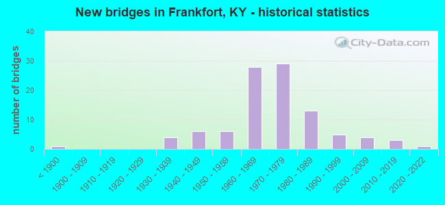
- New bridges - historical statistics
- 1Before 1900
- 41930-1939
- 61940-1949
- 61950-1959
- 281960-1969
- 291970-1979
- 131980-1989
- 51990-1999
- 42000-2009
- 32010-2019
- 12020-2022
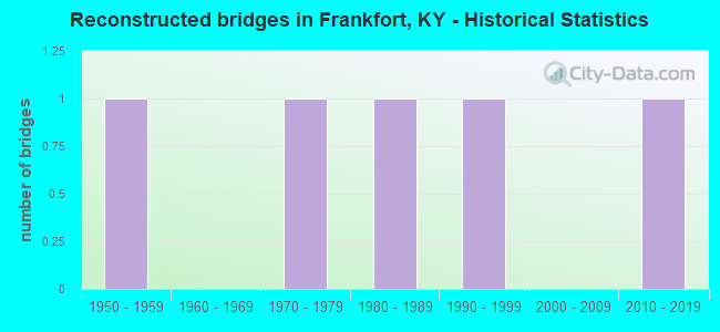
- Reconstructed bridges - Historical Statistics
- 11950-1959
- 01960-1969
- 11970-1979
- 11980-1989
- 11990-1999
- 02000-2009
- 12010-2019
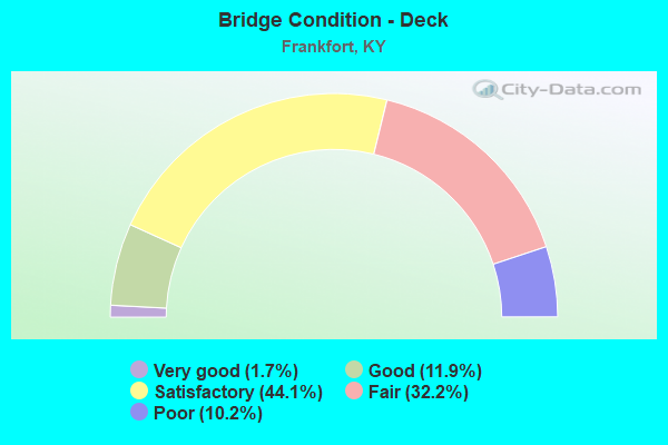
- Bridge Condition - Deck
- 1.7%Very good
- 11.9%Good
- 44.1%Satisfactory
- 32.2%Fair
- 10.2%Poor
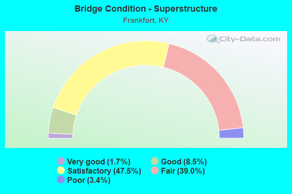
- Bridge Condition - Superstructure
- 1.7%Very good
- 8.5%Good
- 47.5%Satisfactory
- 39.0%Fair
- 3.4%Poor
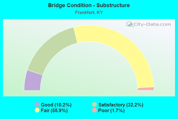
- Bridge Condition - Substructure
- 10.2%Good
- 32.2%Satisfactory
- 55.9%Fair
- 1.7%Poor
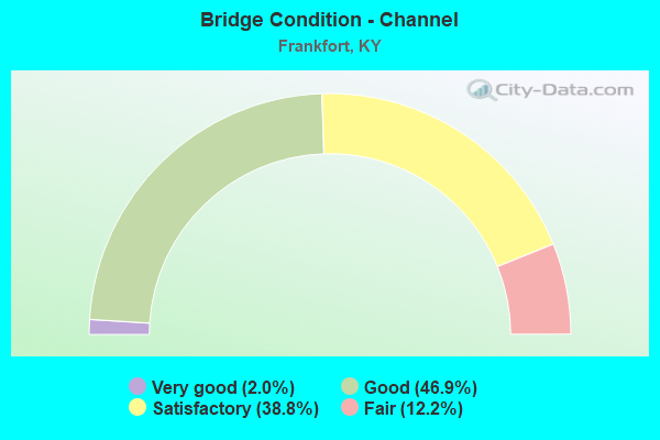
- Bridge Condition - Channel
- 2.0%Very good
- 46.9%Good
- 38.8%Satisfactory
- 12.2%Fair
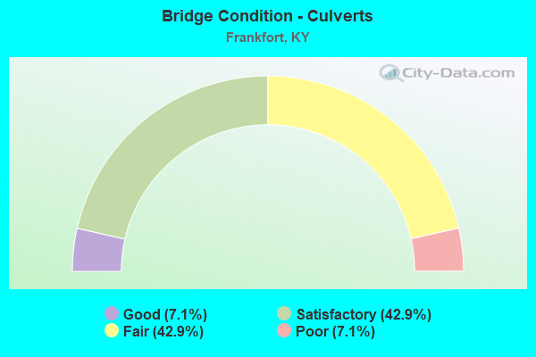
- Bridge Condition - Culverts
- 7.1%Good
- 42.9%Satisfactory
- 42.9%Fair
- 7.1%Poor
Find on map >> Show street view
Structure Number: 37B00006N, Location: 0.1 MI W OF KY 1689 (Lat: 38.215000, Lng: -84.798611), Route carried "on" structure: US 460, Year Built: 1934, Year Reconstructed: 1970, Status: Posted for load, Structure Length: 4.45m (14.60ft), Average Daily Traffic: 5,961 (year 2020), Truck Traffic: 8%, Average Future Daily Traffic: 5,543 (year 2040), Design Load: H 15, Features Intersected: S ELKHORN CREEK
Minimum Vertical Clearance: 30+ m (98+ ft), Kilometerpoint: 3.536, Lanes on structure: 2, Owner: State Highway Agency, Approaching Roadway Width: 7.3m (24.0ft), Material/Design: Concrete, Design/Construction: Tee Beam, Number Of Spans In Main Unit: 3, Length of Maximum Span: 14.6m (47.9ft), Curb or Sidewalk Widths: Left: 0.9m (3.0ft), Right: 0.0m, Curb-To-Curb Width: 7.2m (23.6ft), Out-to-Out Width: 9.1m (29.9ft)
Condition: Deck: Fair, Superstructure: Fair, Substructure: Fair, Channel: Good, Operating Rating: 47.3 metric tons, Method Used To Determine Operating Rating: Load Factor (LF), Inventory Rating: 28.3 metric tons, Method Used To Determine Inventory Rating: Load Factor (LF), Structural Evaluation: Somewhat better than minimum adequacy, Deck Geometry: High priority of replacement, Waterway Adequacy: Superior to present desirable criteria, Approach Roadway Alignment: Equal to present desirable criteria, Bridge Posting: Required (Relationship of Operating Rating to Maximum Legal Load: 20.0 - 29.9% below), Length Of Structure Improvement: 0.44m (1.44ft), Designated Inspection Frequency: Every 24 months, Inspection Date: July 2020, Bridge Improvement Cost: $536,000, Total Project Cost: $536,000, Deck Structure Type: Concrete Cast-file-Place, Wearing Surface/Protective System: Wearing Surface: Latex Concrete
Find on map >> Show street view
Structure Number: 37B00008N, Location: 500 FT E OF KY 676 (Lat: 38.187778, Lng: -84.821111), Route carried "on" structure: US 60, Year Built: 1960, Status: Open, Structure Length: 6.36m (20.87ft), Average Daily Traffic: 24,826 (year 2018), Truck Traffic: 7%, Average Future Daily Traffic: 23,336 (year 2038), Design Load: HS 20, Features Intersected: RJ CORMAN RAILROAD
Minimum Vertical Clearance: 30+ m (98+ ft), Kilometerpoint: 19.657, Lanes on structure: 4, Base Highway Network: Yes, Owner: State Highway Agency, Approaching Roadway Width: 28.7m (94.2ft), Skew: 5 degrees, Material/Design: Concrete continuous, Design/Construction: Tee Beam, Number Of Spans In Main Unit: 3, Length of Maximum Span: 24.4m (80.1ft), Curb or Sidewalk Widths: Left: 0.8m (2.6ft), Right: 0.8m (2.6ft), Curb-To-Curb Width: 28.7m (94.2ft), Out-to-Out Width: 30.9m (101.4ft)
Condition: Deck: Fair, Superstructure: Fair, Substructure: Fair, Operating Rating: 61.3 metric tons, Method Used To Determine Operating Rating: Load Factor (LF), Inventory Rating: 36.8 metric tons, Method Used To Determine Inventory Rating: Load Factor (LF), Structural Evaluation: Somewhat better than minimum adequacy, Deck Geometry: Superior to present desirable criteria, Underclear: Better than present minimum criteria, Approach Roadway Alignment: Equal to present desirable criteria, Designated Inspection Frequency: Every 24 months, Inspection Date: July 2020, Deck Structure Type: Concrete Cast-file-Place, Wearing Surface/Protective System: Wearing Surface: Latex Concrete
Find on map >> Show street view
Structure Number: 37B00009N, Location: 2 MI N OF WOODFORD CL (Lat: 38.186944, Lng: -84.802778), Route carried "on" structure: US 421, Year Built: 1949, Year Reconstructed: 2010, Status: Open, Structure Length: 0.74m (2.43ft), Average Daily Traffic: 14,631 (year 2019), Truck Traffic: 9%, Average Future Daily Traffic: 13,606 (year 2039), Design Load: H 20, Features Intersected: SLICKAWAY BRANCH
Minimum Vertical Clearance: 30+ m (98+ ft), Kilometerpoint: 3.195, Lanes on structure: 4, Owner: State Highway Agency, Approaching Roadway Width: 18.3m (60.0ft), Skew: 3 degrees, Material/Design: Concrete, Design/Construction: Culvert, Number Of Spans In Main Unit: 2, Length of Maximum Span: 3.5m (11.5ft)
Condition: Channel: Satisfactory, Culverts: Fair, Structural Evaluation: Somewhat better than minimum adequacy, Waterway Adequacy: Equal to present desirable criteria, Approach Roadway Alignment: Equal to present desirable criteria, Designated Inspection Frequency: Every 24 months, Inspection Date: July 2020
Find on map >> Show street view
Structure Number: 37B00010N, Location: 1.25 MI N OF WOODFORD CL (Lat: 38.184722, Lng: -84.790000), Route carried "on" structure: US 421, Year Built: 1949, Status: Open, Structure Length: 0.70m (2.30ft), Average Daily Traffic: 6,665 (year 2018), Truck Traffic: 9%, Average Future Daily Traffic: 6,198 (year 2038), Design Load: H 15, Features Intersected: HICKMAN BRANCH
Minimum Vertical Clearance: 30+ m (98+ ft), Kilometerpoint: 2.018, Lanes on structure: 2, Owner: State Highway Agency, Approaching Roadway Width: 8.8m (28.9ft), Skew: 3 degrees, Material/Design: Concrete, Design/Construction: Culvert, Number Of Spans In Main Unit: 1, Length of Maximum Span: 7.0m (23.0ft)
Condition: Channel: Good, Culverts: Satisfactory, Operating Rating: 99.8 metric tons, Method Used To Determine Operating Rating: Load Factor (LF), Inventory Rating: 99.8 metric tons, Method Used To Determine Inventory Rating: Load Factor (LF), Structural Evaluation: Equal to present minimum criteria, Waterway Adequacy: Equal to present desirable criteria, Approach Roadway Alignment: Equal to present desirable criteria, Designated Inspection Frequency: Every 24 months, Inspection Date: July 2020
Find on map >> Show street view
Structure Number: 37B00012N, Location: 1 MI N OF US 127 (Lat: 38.153333, Lng: -84.882222), Route carried "on" structure: State highway 420, Year Built: 1932, Status: Open, Structure Length: 0.64m (2.10ft), Average Daily Traffic: 3,181 (year 2020), Average Future Daily Traffic: 2,958 (year 2040), Design Load: H 15, Features Intersected: CEDAR RUN
Minimum Vertical Clearance: 30+ m (98+ ft), Kilometerpoint: 1.537, Lanes on structure: 2, Owner: State Highway Agency, Approaching Roadway Width: 7.6m (24.9ft), Material/Design: Concrete, Design/Construction: Culvert, Number Of Spans In Main Unit: 2, Length of Maximum Span: 3.0m (9.8ft)
Condition: Channel: Satisfactory, Culverts: Fair, Structural Evaluation: Somewhat better than minimum adequacy, Waterway Adequacy: Equal to present desirable criteria, Approach Roadway Alignment: Equal to present desirable criteria, Designated Inspection Frequency: Every 24 months, Inspection Date: July 2020
Find on map >> Show street view
Structure Number: 37B00014N, Location: 1.5 MI S OF KY 1262 (Lat: 38.268333, Lng: -84.814167), Route carried "on" structure: State highway 1900, Year Built: 1970, Status: Open, Structure Length: 7.85m (25.75ft), Average Daily Traffic: 671 (year 2020), Average Future Daily Traffic: 590 (year 2040), Design Load: H 20, Features Intersected: ELKHORN CREEK
Minimum Vertical Clearance: 30+ m (98+ ft), Kilometerpoint: 7.139, Lanes on structure: 2, Owner: State Highway Agency, Approaching Roadway Width: 6.1m (20.0ft), Skew: 1 degrees, Material/Design: Prestressed concrete continuous, Design/Construction: Stringer/Multi-beam, Number Of Spans In Main Unit: 3, Number Of Approach Spans: 1, Length of Maximum Span: 23.3m (76.4ft), Curb or Sidewalk Widths: Left: 0.2m (0.7ft), Right: 0.2m (0.7ft), Curb-To-Curb Width: 7.3m (24.0ft), Out-to-Out Width: 8.4m (27.6ft)
Condition: Deck: Fair, Superstructure: Fair, Substructure: Fair, Channel: Good, Operating Rating: 80.1 metric tons, Method Used To Determine Operating Rating: Load Factor (LF), Inventory Rating: 48.1 metric tons, Method Used To Determine Inventory Rating: Load Factor (LF), Structural Evaluation: Somewhat better than minimum adequacy, Deck Geometry: Meets minimum limits, Waterway Adequacy: Equal to present desirable criteria, Approach Roadway Alignment: Equal to present desirable criteria, Designated Inspection Frequency: Every 24 months, Inspection Date: July 2020, Deck Structure Type: Concrete Cast-file-Place, Wearing Surface/Protective System: Wearing Surface: Monolithic Concrete
Find on map >> Show street view
Structure Number: 37B00016N, Location: 0.95 MI E OF US 127 (Lat: 38.186389, Lng: -84.879722), Route carried "on" structure: US 60, Year Built: 1941, Year Reconstructed: 1985, Status: Open, Structure Length: 10.42m (34.19ft), Average Daily Traffic: 5,972 (year 2019), Truck Traffic: 7%, Average Future Daily Traffic: 5,553 (year 2039), Design Load: H 15, Features Intersected: LAFAYETTE DR
Minimum Vertical Clearance: 30+ m (98+ ft), Kilometerpoint: 11.735, Lanes on structure: 3, Lanes under structure: 2, Owner: State Highway Agency, Approaching Roadway Width: 10.7m (35.1ft), Skew: 5 degrees, Material/Design: Concrete, Design/Construction: Tee Beam, Number Of Spans In Main Unit: 8, Length of Maximum Span: 18.9m (62.0ft), Curb or Sidewalk Widths: Left: 0.2m (0.7ft), Right: 1.5m (4.9ft), Curb-To-Curb Width: 12.3m (40.4ft), Out-to-Out Width: 14.7m (48.2ft)
Condition: Deck: Satisfactory, Superstructure: Fair, Substructure: Fair, Operating Rating: 55.7 metric tons, Method Used To Determine Operating Rating: Load Factor (LF), Inventory Rating: 33.5 metric tons, Method Used To Determine Inventory Rating: Load Factor (LF), Structural Evaluation: Somewhat better than minimum adequacy, Deck Geometry: Meets minimum limits, Underclear: High priority of corrective action, Approach Roadway Alignment: Equal to present minimum criteria, Length Of Structure Improvement: 1.04m (3.41ft), Designated Inspection Frequency: Every 24 months, Inspection Date: July 2020, Bridge Improvement Cost: $2,052,000, Total Project Cost: $2,052,000, Deck Structure Type: Concrete Cast-file-Place, Wearing Surface/Protective System: Wearing Surface: Latex Concrete, Deck Protection: Epoxy Coated Reinforcing
Find on map >> Show street view
Structure Number: 37B00019N, Location: 0.85 MI E OF KY 1665 (Lat: 38.166389, Lng: -84.938056), Route carried "on" structure: US 60, Year Built: 1941, Status: Open, Structure Length: 1.13m (3.71ft), Average Daily Traffic: 5,727 (year 2020), Truck Traffic: 9%, Average Future Daily Traffic: 4,753 (year 2040), Design Load: H 15, Features Intersected: FK OF S BENSON CREEK
Minimum Vertical Clearance: 30+ m (98+ ft), Kilometerpoint: 6.058, Lanes on structure: 2, Base Highway Network: Yes, Owner: State Highway Agency, Approaching Roadway Width: 8.5m (27.9ft), Skew: 3 degrees, Material/Design: Concrete, Design/Construction: Culvert, Number Of Spans In Main Unit: 3, Length of Maximum Span: 3.5m (11.5ft)
Condition: Channel: Satisfactory, Culverts: Fair, Operating Rating: 82.0 metric tons, Method Used To Determine Operating Rating: Load Factor (LF), Inventory Rating: 49.2 metric tons, Method Used To Determine Inventory Rating: Load Factor (LF), Structural Evaluation: Somewhat better than minimum adequacy, Waterway Adequacy: Equal to present desirable criteria, Approach Roadway Alignment: Equal to present desirable criteria, Designated Inspection Frequency: Every 24 months, Inspection Date: July 2020
Find on map >> Show street view
Structure Number: 37B00029N, Location: 0.95 MI S OF US 60 (Lat: 38.173611, Lng: -84.825556), Route carried "on" structure: State highway 2821, Year Built: 1962, Status: Posted for load, Structure Length: 10.57m (34.68ft), Average Daily Traffic: 597 (year 2018), Average Future Daily Traffic: 519 (year 2038), Design Load: H 20, Features Intersected: I-64
Minimum Vertical Clearance: 30+ m (98+ ft), Kilometerpoint: 3.095, Lanes on structure: 2, Lanes under structure: 4, Owner: State Highway Agency, Approaching Roadway Width: 6.1m (20.0ft), Skew: 2 degrees, Material/Design: Concrete continuous, Design/Construction: Tee Beam, Number Of Spans In Main Unit: 6, Length of Maximum Span: 21.3m (69.9ft), Curb or Sidewalk Widths: Left: 0.9m (3.0ft), Right: 0.9m (3.0ft), Curb-To-Curb Width: 7.3m (24.0ft), Out-to-Out Width: 9.6m (31.5ft)
Condition: Deck: Fair, Superstructure: Satisfactory, Substructure: Fair, Operating Rating: 42.8 metric tons, Method Used To Determine Operating Rating: Load Factor (LF), Inventory Rating: 25.7 metric tons, Method Used To Determine Inventory Rating: Load Factor (LF), Structural Evaluation: Somewhat better than minimum adequacy, Deck Geometry: Meets minimum limits, Underclear: Somewhat better than minimum adequacy, Approach Roadway Alignment: Equal to present desirable criteria, Bridge Posting: Required (Relationship of Operating Rating to Maximum Legal Load: 30.0 - 39.9% below), Designated Inspection Frequency: Every 24 months, Inspection Date: August 2020, Deck Structure Type: Concrete Cast-file-Place, Wearing Surface/Protective System: Wearing Surface: Latex Concrete
Find on map >> Show street view
Structure Number: 37B00032N, Location: 250 FT E OF US 460 (Lat: 38.216667, Lng: -84.797500), Route carried "on" structure: State highway 1689, Year Built: 1955, Status: Posted for load, Structure Length: 8.08m (26.51ft), Average Daily Traffic: 1,613 (year 2018), Average Future Daily Traffic: 1,419 (year 2038), Design Load: H 20, Features Intersected: N ELKHORN CREEK
Minimum Vertical Clearance: 30+ m (98+ ft), Kilometerpoint: 0.077, Lanes on structure: 2, Owner: State Highway Agency, Approaching Roadway Width: 6.7m (22.0ft), Skew: 3 degrees, Material/Design: Concrete, Design/Construction: Tee Beam, Number Of Spans In Main Unit: 5, Length of Maximum Span: 15.2m (49.9ft), Curb or Sidewalk Widths: Left: 0.8m (2.6ft), Right: 0.8m (2.6ft), Curb-To-Curb Width: 7.9m (25.9ft), Out-to-Out Width: 10.2m (33.5ft)
Condition: Deck: Fair, Superstructure: Satisfactory, Substructure: Fair, Channel: Good, Operating Rating: 46.6 metric tons, Method Used To Determine Operating Rating: Load Factor (LF), Inventory Rating: 28.0 metric tons, Method Used To Determine Inventory Rating: Load Factor (LF), Structural Evaluation: Somewhat better than minimum adequacy, Deck Geometry: Meets minimum limits, Waterway Adequacy: Equal to present desirable criteria, Approach Roadway Alignment: Equal to present minimum criteria, Bridge Posting: Required (Relationship of Operating Rating to Maximum Legal Load: 20.0 - 29.9% below), Designated Inspection Frequency: Every 24 months, Inspection Date: July 2020, Deck Structure Type: Concrete Cast-file-Place, Wearing Surface/Protective System: Wearing Surface: Low Slump Concrete
Find on map >> Show street view
Structure Number: 37B00036N, Location: 0.40 MI S OF KY 1005 (Lat: 38.206667, Lng: -84.960278), Route carried "on" structure: State highway 1665, Year Built: 1951, Status: Posted for load, Structure Length: 5.79m (19.00ft), Average Daily Traffic: 333 (year 2019), Average Future Daily Traffic: 293 (year 2039), Design Load: H 15, Features Intersected: BENSON CREEK
Minimum Vertical Clearance: 30+ m (98+ ft), Kilometerpoint: 12.257, Lanes on structure: 2, Owner: State Highway Agency, Approaching Roadway Width: 5.5m (18.0ft), Material/Design: Concrete, Design/Construction: Tee Beam, Number Of Spans In Main Unit: 5, Length of Maximum Span: 10.7m (35.1ft), Curb or Sidewalk Widths: Left: 0.3m (1.0ft), Right: 0.3m (1.0ft), Curb-To-Curb Width: 5.8m (19.0ft), Out-to-Out Width: 7.0m (23.0ft)
Condition: Deck: Poor, Superstructure: Fair, Substructure: Fair, Channel: Satisfactory, Operating Rating: 34.1 metric tons, Method Used To Determine Operating Rating: Load Factor (LF), Inventory Rating: 20.5 metric tons, Method Used To Determine Inventory Rating: Load Factor (LF), Structural Evaluation: Somewhat better than minimum adequacy, Deck Geometry: High priority of corrective action, Waterway Adequacy: Equal to present desirable criteria, Approach Roadway Alignment: Equal to present desirable criteria, Bridge Posting: Required (Relationship of Operating Rating to Maximum Legal Load: > 39.9% below), Length Of Structure Improvement: 0.60m (1.97ft), Designated Inspection Frequency: Every 24 months, Inspection Date: July 2020, Bridge Improvement Cost: $544,000, Total Project Cost: $543,000, Deck Structure Type: Concrete Cast-file-Place, Wearing Surface/Protective System: Wearing Surface: Bituminous, Membrane: Preformed Fabric
Find on map >> Show street view
Structure Number: 37B00038N, Location: 350 FT N OF US 60 (Lat: 38.163056, Lng: -84.953056), Route carried "on" structure: State highway 1665, Year Built: 1966, Status: Posted for load, Structure Length: 2.56m (8.40ft), Average Daily Traffic: 562 (year 2018), Average Future Daily Traffic: 494 (year 2038), Design Load: H 20, Features Intersected: S BENSON CREEK
Minimum Vertical Clearance: 30+ m (98+ ft), Kilometerpoint: 6.371, Lanes on structure: 2, Owner: State Highway Agency, Approaching Roadway Width: 5.8m (19.0ft), Material/Design: Prestressed concrete, Design/Construction: Box Beam or Girders - Multiple, Number Of Spans In Main Unit: 2, Length of Maximum Span: 11.9m (39.0ft), Curb or Sidewalk Widths: Left: 0.1m (0.3ft), Right: 0.1m (0.3ft), Curb-To-Curb Width: 6.8m (22.3ft), Out-to-Out Width: 7.4m (24.3ft)
Condition: Deck: Fair, Superstructure: Poor, Substructure: Poor, Channel: Fair, Operating Rating: 33.7 metric tons, Method Used To Determine Operating Rating: Load Factor (LF), Inventory Rating: 20.2 metric tons, Method Used To Determine Inventory Rating: Load Factor (LF), Structural Evaluation: Meets minimum limits, Deck Geometry: Meets minimum limits, Waterway Adequacy: Equal to present desirable criteria, Approach Roadway Alignment: Equal to present minimum criteria, Bridge Posting: Required (Relationship of Operating Rating to Maximum Legal Load: > 39.9% below), Designated Inspection Frequency: Every 24 months, Inspection Date: July 2020, Deck Structure Type: Concrete Precast Panels, Wearing Surface/Protective System: Wearing Surface: Bituminous
Find on map >> Show street view
Structure Number: 37B00044N, Location: 2.3 MI N OF KY 1707 (Lat: 38.280000, Lng: -84.823056), Route carried "on" structure: State highway 1262, Year Built: 1950, Status: Posted for load, Structure Length: 0.74m (2.43ft), Average Daily Traffic: 447 (year 2018), Average Future Daily Traffic: 393 (year 2038), Design Load: HS 20, Features Intersected: JOHN BRANCH
Minimum Vertical Clearance: 30+ m (98+ ft), Kilometerpoint: 17.869, Lanes on structure: 2, Owner: State Highway Agency, Approaching Roadway Width: 6.3m (20.7ft), Skew: 3 degrees, Material/Design: Concrete, Design/Construction: Culvert, Number Of Spans In Main Unit: 2, Length of Maximum Span: 3.5m (11.5ft), Curb-To-Curb Width: 6.3m (20.7ft), Out-to-Out Width: 7.4m (24.3ft)
Condition: Channel: Good, Culverts: Satisfactory, Operating Rating: 20.0 metric tons, Method Used To Determine Operating Rating: Field evaluation and documented engineering judgment, Inventory Rating: 20.0 metric tons, Method Used To Determine Inventory Rating: Field evaluation and documented engineering judgment, Structural Evaluation: Somewhat better than minimum adequacy, Deck Geometry: High priority of corrective action, Waterway Adequacy: Better than present minimum criteria, Approach Roadway Alignment: Equal to present minimum criteria, Bridge Posting: Required (Relationship of Operating Rating to Maximum Legal Load: > 39.9% below), Designated Inspection Frequency: Every 24 months, Inspection Date: July 2020
Find on map >> Show street view
Structure Number: 37B00051L, Location: 0.7 MI E OF US 127 NTRCH (Lat: 38.158889, Lng: -84.881111), Route carried "on" structure: Interstate 64, Year Built: 1962, Status: Open, Structure Length: 16.03m (52.59ft), Average Daily Traffic: 20,362 (year 2020), Truck Traffic: 23%, Average Future Daily Traffic: 24,842 (year 2040), Design Load: HS 20, Features Intersected: KY 420 & CEDAR RUN
Minimum Vertical Clearance: 30+ m (98+ ft), Kilometerpoint: 86.526, Lanes on structure: 2, Lanes under structure: 2, Base Highway Network: Yes, Owner: State Highway Agency, Approaching Roadway Width: 8.8m (28.9ft), Material/Design: Steel continuous, Design/Construction: Stringer/Multi-beam, Number Of Spans In Main Unit: 3, Number Of Approach Spans: 2, Length of Maximum Span: 51.2m (168.0ft), Curb-To-Curb Width: 9.1m (29.9ft), Out-to-Out Width: 10.4m (34.1ft)
Condition: Deck: Fair, Superstructure: Fair, Substructure: Fair, Channel: Good, Operating Rating: 57.4 metric tons, Method Used To Determine Operating Rating: Load Factor (LF), Inventory Rating: 34.5 metric tons, Method Used To Determine Inventory Rating: Load Factor (LF), Structural Evaluation: Somewhat better than minimum adequacy, Deck Geometry: Meets minimum limits, Underclear: Meets minimum limits, Waterway Adequacy: Superior to present desirable criteria, Approach Roadway Alignment: Equal to present desirable criteria, Length Of Structure Improvement: 1.60m (5.25ft), Designated Inspection Frequency: Every 24 months, Inspection Date: August 2020, Bridge Improvement Cost: $2,998,000, Total Project Cost: $2,998,000, Deck Structure Type: Concrete Cast-file-Place, Wearing Surface/Protective System: Wearing Surface: Latex Concrete
Find on map >> Show street view
Structure Number: 37B00051R, Location: 0.7 MI E OF US 127 NTRCH (Lat: 38.157222, Lng: -84.881111), Route carried "on" structure: Interstate 64, Year Built: 1962, Status: Open, Structure Length: 12.50m (41.01ft), Average Daily Traffic: 20,362 (year 2020), Truck Traffic: 23%, Average Future Daily Traffic: 24,842 (year 2040), Design Load: HS 20, Features Intersected: KY 420 & CEDAR RUN
Minimum Vertical Clearance: 30+ m (98+ ft), Kilometerpoint: 86.615, Lanes on structure: 2, Lanes under structure: 2, Base Highway Network: Yes, Owner: State Highway Agency, Approaching Roadway Width: 8.8m (28.9ft), Material/Design: Steel continuous, Design/Construction: Stringer/Multi-beam, Number Of Spans In Main Unit: 3, Length of Maximum Span: 51.2m (168.0ft), Curb-To-Curb Width: 9.1m (29.9ft), Out-to-Out Width: 10.4m (34.1ft)
Condition: Deck: Fair, Superstructure: Fair, Substructure: Fair, Channel: Good, Operating Rating: 66.1 metric tons, Method Used To Determine Operating Rating: Load Factor (LF), Inventory Rating: 39.6 metric tons, Method Used To Determine Inventory Rating: Load Factor (LF), Structural Evaluation: Somewhat better than minimum adequacy, Deck Geometry: Meets minimum limits, Underclear: Meets minimum limits, Waterway Adequacy: Superior to present desirable criteria, Approach Roadway Alignment: Equal to present desirable criteria, Designated Inspection Frequency: Every 24 months, Inspection Date: August 2020, Deck Structure Type: Concrete Cast-file-Place, Wearing Surface/Protective System: Wearing Surface: Latex Concrete
Find on map >> Show street view
Structure Number: 37B00052L, Location: 2.3 MI E OF US 127 NTRCH (Lat: 38.161944, Lng: -84.851944), Route carried "on" structure: Interstate 64, Year Built: 1963, Status: Posted for load, Structure Length: 23.60m (77.43ft), Average Daily Traffic: 20,362 (year 2020), Truck Traffic: 23%, Average Future Daily Traffic: 24,842 (year 2040), Design Load: H 20, Features Intersected: KENTUCKY RIVER
Minimum Vertical Clearance: 30+ m (98+ ft), Kilometerpoint: 89.162, Lanes on structure: 2, Lanes under structure: 2, Base Highway Network: Yes, Owner: State Highway Agency, Approaching Roadway Width: 9.1m (29.9ft), Navigation Control: Yes ( Vertical Clearance: 34.7m (113.8ft), Horizontal Clearance: 93.0m (305.1ft)), Material/Design: Steel continuous, Design/Construction: Girder and Floorbeam System, Number Of Spans In Main Unit: 3, Length of Maximum Span: 96.0m (315.0ft), Curb-To-Curb Width: 9.1m (29.9ft), Out-to-Out Width: 10.5m (34.4ft)
Condition: Deck: Poor, Superstructure: Fair, Substructure: Fair, Channel: Good, Operating Rating: 39.1 metric tons, Method Used To Determine Operating Rating: Load Factor (LF), Inventory Rating: 23.5 metric tons, Method Used To Determine Inventory Rating: Load Factor (LF), Structural Evaluation: Somewhat better than minimum adequacy, Deck Geometry: Meets minimum limits, Underclear: High priority of corrective action, Waterway Adequacy: Superior to present desirable criteria, Approach Roadway Alignment: Equal to present desirable criteria, Bridge Posting: Required (Relationship of Operating Rating to Maximum Legal Load: 20.0 - 29.9% below), Length Of Structure Improvement: 2.36m (7.74ft), Designated Inspection Frequency: Every 24 months, Critical Feature Inspection Frequency: Every 24 months, Inspection Date: October 2021, Critical Feature Inspection Date: October 2021, Bridge Improvement Cost: $3,676,000, Total Project Cost: $3,676,000, Deck Structure Type: Concrete Cast-file-Place, Wearing Surface/Protective System: Wearing Surface: Bituminous
Find on map >> Show street view
Structure Number: 37B00052R, Location: 2.3 MI E OF US 127 NTRCH (Lat: 38.160833, Lng: -84.851667), Route carried "on" structure: Interstate 64, Year Built: 1963, Status: Posted for load, Structure Length: 23.60m (77.43ft), Average Daily Traffic: 20,362 (year 2020), Truck Traffic: 23%, Average Future Daily Traffic: 24,842 (year 2040), Design Load: H 20, Features Intersected: KENTUCKY RIVER
Minimum Vertical Clearance: 30+ m (98+ ft), Kilometerpoint: 89.259, Lanes on structure: 2, Lanes under structure: 2, Base Highway Network: Yes, Owner: State Highway Agency, Approaching Roadway Width: 9.1m (29.9ft), Navigation Control: Yes ( Vertical Clearance: 34.7m (113.8ft), Horizontal Clearance: 93.0m (305.1ft)), Material/Design: Steel continuous, Design/Construction: Girder and Floorbeam System, Number Of Spans In Main Unit: 3, Length of Maximum Span: 96.0m (315.0ft), Curb-To-Curb Width: 9.1m (29.9ft), Out-to-Out Width: 10.5m (34.4ft)
Condition: Deck: Poor, Superstructure: Fair, Substructure: Fair, Channel: Good, Operating Rating: 39.1 metric tons, Method Used To Determine Operating Rating: Load Factor (LF), Inventory Rating: 23.5 metric tons, Method Used To Determine Inventory Rating: Load Factor (LF), Structural Evaluation: Somewhat better than minimum adequacy, Deck Geometry: Meets minimum limits, Underclear: High priority of corrective action, Waterway Adequacy: Superior to present desirable criteria, Approach Roadway Alignment: Equal to present desirable criteria, Bridge Posting: Required (Relationship of Operating Rating to Maximum Legal Load: 20.0 - 29.9% below), Length Of Structure Improvement: 2.36m (7.74ft), Designated Inspection Frequency: Every 24 months, Critical Feature Inspection Frequency: Every 24 months, Inspection Date: October 2021, Critical Feature Inspection Date: October 2021, Bridge Improvement Cost: $3,676,000, Total Project Cost: $3,676,000, Deck Structure Type: Concrete Cast-file-Place, Wearing Surface/Protective System: Wearing Surface: Bituminous
Find on map >> Show street view
Structure Number: 37B00053L, Location: 1.5 MI W OF WOODFORD CL (Lat: 38.173889, Lng: -84.811667), Route carried "on" structure: Interstate 64, Year Built: 1972, Status: Open, Structure Length: 9.14m (29.99ft), Average Daily Traffic: 20,362 (year 2020), Truck Traffic: 23%, Average Future Daily Traffic: 24,842 (year 2040), Design Load: HS 20, Features Intersected: US 60
Minimum Vertical Clearance: 30+ m (98+ ft), Kilometerpoint: 93.130, Lanes on structure: 2, Lanes under structure: 4, Base Highway Network: Yes, Owner: State Highway Agency, Approaching Roadway Width: 12.2m (40.0ft), Skew: 1 degrees, Material/Design: Steel continuous, Design/Construction: Stringer/Multi-beam, Number Of Spans In Main Unit: 3, Length of Maximum Span: 42.4m (139.1ft), Curb or Sidewalk Widths: Left: 0.2m (0.7ft), Right: 0.2m (0.7ft), Curb-To-Curb Width: 12.0m (39.4ft), Out-to-Out Width: 13.0m (42.7ft)
Condition: Deck: Fair, Superstructure: Fair, Substructure: Satisfactory, Operating Rating: 65.1 metric tons, Method Used To Determine Operating Rating: Load Factor (LF), Inventory Rating: 39.1 metric tons, Method Used To Determine Inventory Rating: Load Factor (LF), Structural Evaluation: Somewhat better than minimum adequacy, Deck Geometry: Equal to present minimum criteria, Underclear: Superior to present desirable criteria, Approach Roadway Alignment: Equal to present desirable criteria, Designated Inspection Frequency: Every 24 months, Inspection Date: August 2020, Deck Structure Type: Concrete Cast-file-Place, Wearing Surface/Protective System: Wearing Surface: Monolithic Concrete
Find on map >> Show street view
Structure Number: 37B00053R, Location: 1.5 MI W OF WOODFORD CL (Lat: 38.173611, Lng: -84.811389), Route carried "on" structure: Interstate 64, Year Built: 1972, Status: Open, Structure Length: 9.14m (29.99ft), Average Daily Traffic: 12,076 (year 2020), Truck Traffic: 31%, Average Future Daily Traffic: 14,733 (year 2040), Design Load: HS 20, Features Intersected: US 60
Minimum Vertical Clearance: 30+ m (98+ ft), Kilometerpoint: 93.194, Lanes on structure: 2, Lanes under structure: 4, Base Highway Network: Yes, Owner: State Highway Agency, Approaching Roadway Width: 12.2m (40.0ft), Skew: 1 degrees, Material/Design: Steel continuous, Design/Construction: Stringer/Multi-beam, Number Of Spans In Main Unit: 3, Length of Maximum Span: 42.4m (139.1ft), Curb or Sidewalk Widths: Left: 0.2m (0.7ft), Right: 0.2m (0.7ft), Curb-To-Curb Width: 12.0m (39.4ft), Out-to-Out Width: 13.0m (42.7ft)
Condition: Deck: Fair, Superstructure: Fair, Substructure: Satisfactory, Operating Rating: 65.1 metric tons, Method Used To Determine Operating Rating: Load Factor (LF), Inventory Rating: 39.1 metric tons, Method Used To Determine Inventory Rating: Load Factor (LF), Structural Evaluation: Somewhat better than minimum adequacy, Deck Geometry: Equal to present minimum criteria, Underclear: Better than present minimum criteria, Approach Roadway Alignment: Equal to present desirable criteria, Designated Inspection Frequency: Every 24 months, Inspection Date: August 2020, Deck Structure Type: Concrete Cast-file-Place, Wearing Surface/Protective System: Wearing Surface: Monolithic Concrete
Find on map >> Show street view
Structure Number: 37B00056L, Location: 2.0 MI E OF KY 151 NTRCH (Lat: 38.151389, Lng: -84.953611), Route carried "on" structure: Interstate 64, Year Built: 1960, Status: Open, Structure Length: 4.75m (15.58ft), Average Daily Traffic: 17,053 (year 2020), Truck Traffic: 21%, Average Future Daily Traffic: 20,805 (year 2040), Design Load: HS 20, Features Intersected: KY 1665 (EVERGREEN RD)
Minimum Vertical Clearance: 30+ m (98+ ft), Kilometerpoint: 80.092, Lanes on structure: 2, Lanes under structure: 2, Base Highway Network: Yes, Owner: State Highway Agency, Approaching Roadway Width: 9.1m (29.9ft), Skew: 1 degrees, Material/Design: Concrete, Design/Construction: Tee Beam, Number Of Spans In Main Unit: 3, Length of Maximum Span: 17.1m (56.1ft), Curb-To-Curb Width: 9.1m (29.9ft), Out-to-Out Width: 11.5m (37.7ft)
Condition: Deck: Fair, Superstructure: Satisfactory, Substructure: Fair, Operating Rating: 86.3 metric tons, Method Used To Determine Operating Rating: Load Factor (LF), Inventory Rating: 51.7 metric tons, Method Used To Determine Inventory Rating: Load Factor (LF), Structural Evaluation: Somewhat better than minimum adequacy, Deck Geometry: High priority of replacement, Underclear: Equal to present minimum criteria, Approach Roadway Alignment: Equal to present desirable criteria, Length Of Structure Improvement: 0.48m (1.57ft), Designated Inspection Frequency: Every 24 months, Inspection Date: August 2020, Bridge Improvement Cost: $741,000, Total Project Cost: $741,000, Deck Structure Type: Concrete Cast-file-Place, Wearing Surface/Protective System: Wearing Surface: Latex Concrete
Find on map >> Show street view
Structure Number: 37B00056R, Location: 2.0 MI E OF KY 151 NTRCH (Lat: 38.151111, Lng: -84.953611), Route carried "on" structure: Interstate 64, Year Built: 1960, Status: Open, Structure Length: 4.75m (15.58ft), Average Daily Traffic: 17,053 (year 2020), Truck Traffic: 21%, Average Future Daily Traffic: 20,805 (year 2040), Design Load: HS 20, Features Intersected: KY 1665 (EVERGREEN RD)
Minimum Vertical Clearance: 30+ m (98+ ft), Kilometerpoint: 80.149, Lanes on structure: 2, Lanes under structure: 2, Base Highway Network: Yes, Owner: State Highway Agency, Approaching Roadway Width: 9.1m (29.9ft), Skew: 1 degrees, Material/Design: Concrete, Design/Construction: Tee Beam, Number Of Spans In Main Unit: 3, Length of Maximum Span: 17.1m (56.1ft), Curb-To-Curb Width: 9.1m (29.9ft), Out-to-Out Width: 11.5m (37.7ft)
Condition: Deck: Satisfactory, Superstructure: Satisfactory, Substructure: Fair, Operating Rating: 86.3 metric tons, Method Used To Determine Operating Rating: Load Factor (LF), Inventory Rating: 51.7 metric tons, Method Used To Determine Inventory Rating: Load Factor (LF), Structural Evaluation: Somewhat better than minimum adequacy, Deck Geometry: High priority of replacement, Underclear: Better than present minimum criteria, Approach Roadway Alignment: Equal to present desirable criteria, Length Of Structure Improvement: 0.48m (1.57ft), Designated Inspection Frequency: Every 24 months, Inspection Date: August 2020, Bridge Improvement Cost: $741,000, Total Project Cost: $741,000, Deck Structure Type: Concrete Cast-file-Place, Wearing Surface/Protective System: Wearing Surface: Latex Concrete
Find on map >> Show street view
Structure Number: 37B00057L, Location: 1.6 MI W OF US 127 NTRCH (Lat: 38.156667, Lng: -84.922500), Route carried "on" structure: Interstate 64, Year Built: 1960, Status: Open, Structure Length: 4.85m (15.91ft), Average Daily Traffic: 17,053 (year 2020), Truck Traffic: 21%, Average Future Daily Traffic: 20,805 (year 2040), Design Load: HS 20, Features Intersected: KY 2817
Minimum Vertical Clearance: 30+ m (98+ ft), Kilometerpoint: 82.907, Lanes on structure: 2, Lanes under structure: 2, Base Highway Network: Yes, Owner: State Highway Agency, Approaching Roadway Width: 11.0m (36.1ft), Skew: 1 degrees, Material/Design: Concrete, Design/Construction: Tee Beam, Number Of Spans In Main Unit: 3, Length of Maximum Span: 16.2m (53.1ft), Curb-To-Curb Width: 9.1m (29.9ft), Out-to-Out Width: 11.5m (37.7ft)
Condition: Deck: Poor, Superstructure: Fair, Substructure: Fair, Operating Rating: 84.7 metric tons, Method Used To Determine Operating Rating: Load Factor (LF), Inventory Rating: 50.9 metric tons, Method Used To Determine Inventory Rating: Load Factor (LF), Structural Evaluation: Somewhat better than minimum adequacy, Deck Geometry: High priority of replacement, Underclear: Equal to present minimum criteria, Approach Roadway Alignment: Equal to present desirable criteria, Length Of Structure Improvement: 0.48m (1.57ft), Designated Inspection Frequency: Every 24 months, Inspection Date: August 2020, Bridge Improvement Cost: $755,000, Total Project Cost: $755,000, Deck Structure Type: Concrete Cast-file-Place, Wearing Surface/Protective System: Wearing Surface: Latex Concrete
Find on map >> Show street view
Structure Number: 37B00057R, Location: 1.6 MI W OF US 127 NTRCH (Lat: 38.156389, Lng: -84.922500), Route carried "on" structure: Interstate 64, Year Built: 1960, Status: Open, Structure Length: 4.85m (15.91ft), Average Daily Traffic: 17,053 (year 2020), Truck Traffic: 21%, Average Future Daily Traffic: 20,805 (year 2040), Design Load: HS 20, Features Intersected: KY 2817
Minimum Vertical Clearance: 30+ m (98+ ft), Kilometerpoint: 82.965, Lanes on structure: 2, Lanes under structure: 2, Base Highway Network: Yes, Owner: State Highway Agency, Approaching Roadway Width: 11.0m (36.1ft), Skew: 1 degrees, Material/Design: Concrete, Design/Construction: Tee Beam, Number Of Spans In Main Unit: 3, Length of Maximum Span: 16.2m (53.1ft), Curb-To-Curb Width: 9.1m (29.9ft), Out-to-Out Width: 11.5m (37.7ft)
Condition: Deck: Poor, Superstructure: Fair, Substructure: Fair, Operating Rating: 84.7 metric tons, Method Used To Determine Operating Rating: Load Factor (LF), Inventory Rating: 50.9 metric tons, Method Used To Determine Inventory Rating: Load Factor (LF), Structural Evaluation: Somewhat better than minimum adequacy, Deck Geometry: High priority of replacement, Underclear: Better than present minimum criteria, Approach Roadway Alignment: Equal to present desirable criteria, Length Of Structure Improvement: 0.48m (1.57ft), Designated Inspection Frequency: Every 24 months, Inspection Date: August 2020, Bridge Improvement Cost: $755,000, Total Project Cost: $755,000, Deck Structure Type: Concrete Cast-file-Place, Wearing Surface/Protective System: Wearing Surface: Latex Concrete
Find on map >> Show street view
Structure Number: 37B00058L, Location: 1.8 MI E OF US 127 NTRCH (Lat: 38.160000, Lng: -84.859722), Route carried "on" structure: Interstate 64, Year Built: 1962, Status: Open, Structure Length: 1.62m (5.31ft), Average Daily Traffic: 20,362 (year 2020), Truck Traffic: 23%, Average Future Daily Traffic: 24,842 (year 2040), Design Load: HS 20, Features Intersected: KY 1263
Minimum Vertical Clearance: 30+ m (98+ ft), Kilometerpoint: 88.483, Lanes on structure: 2, Lanes under structure: 2, Base Highway Network: Yes, Owner: State Highway Agency, Approaching Roadway Width: 12.2m (40.0ft), Skew: 3 degrees, Material/Design: Concrete, Design/Construction: Tee Beam, Number Of Spans In Main Unit: 1, Length of Maximum Span: 15.2m (49.9ft), Curb-To-Curb Width: 12.2m (40.0ft), Out-to-Out Width: 13.2m (43.3ft)
Condition: Deck: Satisfactory, Superstructure: Fair, Substructure: Fair, Operating Rating: 82.6 metric tons, Method Used To Determine Operating Rating: Load Factor (LF), Inventory Rating: 49.6 metric tons, Method Used To Determine Inventory Rating: Load Factor (LF), Structural Evaluation: Somewhat better than minimum adequacy, Deck Geometry: Better than present minimum criteria, Underclear: Meets minimum limits, Approach Roadway Alignment: Equal to present desirable criteria, Designated Inspection Frequency: Every 24 months, Inspection Date: August 2020, Deck Structure Type: Concrete Cast-file-Place, Wearing Surface/Protective System: Wearing Surface: Bituminous, Membrane: Other
Find on map >> Show street view
Structure Number: 37B00058R, Location: 1.8 MI E OF US 127 NTRCH (Lat: 38.158333, Lng: -84.860278), Route carried "on" structure: Interstate 64, Year Built: 1962, Status: Open, Structure Length: 3.63m (11.91ft), Average Daily Traffic: 20,362 (year 2020), Truck Traffic: 23%, Average Future Daily Traffic: 24,842 (year 2040), Design Load: HS 20, Features Intersected: KY 1263
Minimum Vertical Clearance: 30+ m (98+ ft), Kilometerpoint: 88.443, Lanes on structure: 2, Lanes under structure: 2, Base Highway Network: Yes, Owner: State Highway Agency, Approaching Roadway Width: 12.2m (40.0ft), Material/Design: Concrete, Design/Construction: Tee Beam, Number Of Spans In Main Unit: 3, Length of Maximum Span: 15.2m (49.9ft), Curb-To-Curb Width: 12.2m (40.0ft), Out-to-Out Width: 13.2m (43.3ft)
Condition: Deck: Fair, Superstructure: Satisfactory, Substructure: Fair, Operating Rating: 62.9 metric tons, Method Used To Determine Operating Rating: Load Factor (LF), Inventory Rating: 37.7 metric tons, Method Used To Determine Inventory Rating: Load Factor (LF), Structural Evaluation: Somewhat better than minimum adequacy, Deck Geometry: Better than present minimum criteria, Underclear: Better than present minimum criteria, Approach Roadway Alignment: Equal to present desirable criteria, Designated Inspection Frequency: Every 24 months, Inspection Date: August 2020, Deck Structure Type: Concrete Cast-file-Place, Wearing Surface/Protective System: Wearing Surface: Bituminous, Membrane: Other
Find on map >> Show street view
Structure Number: 37B00060L, Location: 1.4 MI E OF KY 151 NTRCH (Lat: 38.149444, Lng: -84.965278), Route carried "on" structure: Interstate 64, Year Built: 1960, Status: Open, Structure Length: 6.50m (21.33ft), Average Daily Traffic: 17,053 (year 2020), Truck Traffic: 21%, Average Future Daily Traffic: 20,805 (year 2040), Design Load: HS 20, Features Intersected: S BENSON CREEK
Minimum Vertical Clearance: 30+ m (98+ ft), Kilometerpoint: 79.033, Lanes on structure: 2, Base Highway Network: Yes, Owner: State Highway Agency, Approaching Roadway Width: 9.1m (29.9ft), Material/Design: Concrete continuous, Design/Construction: Tee Beam, Number Of Spans In Main Unit: 3, Length of Maximum Span: 26.2m (86.0ft), Curb-To-Curb Width: 9.1m (29.9ft), Out-to-Out Width: 11.5m (37.7ft)
Condition: Deck: Fair, Superstructure: Satisfactory, Substructure: Fair, Channel: Satisfactory, Operating Rating: 70.8 metric tons, Method Used To Determine Operating Rating: Load Factor (LF), Inventory Rating: 42.5 metric tons, Method Used To Determine Inventory Rating: Load Factor (LF), Structural Evaluation: Somewhat better than minimum adequacy, Deck Geometry: Meets minimum limits, Waterway Adequacy: Superior to present desirable criteria, Approach Roadway Alignment: Equal to present desirable criteria, Designated Inspection Frequency: Every 24 months, Inspection Date: August 2020, Deck Structure Type: Concrete Cast-file-Place, Wearing Surface/Protective System: Wearing Surface: Latex Concrete
Find on map >> Show street view
Structure Number: 37B00060R, Location: 1.4 M E OF KY 151 NTRCH (Lat: 38.148889, Lng: -84.965278), Route carried "on" structure: Interstate 64, Year Built: 1960, Status: Open, Structure Length: 6.50m (21.33ft), Average Daily Traffic: 17,053 (year 2020), Truck Traffic: 21%, Average Future Daily Traffic: 20,805 (year 2040), Design Load: HS 20, Features Intersected: S BENSON CREEK
Minimum Vertical Clearance: 30+ m (98+ ft), Kilometerpoint: 79.094, Lanes on structure: 2, Base Highway Network: Yes, Owner: State Highway Agency, Approaching Roadway Width: 9.1m (29.9ft), Material/Design: Concrete continuous, Design/Construction: Tee Beam, Number Of Spans In Main Unit: 3, Length of Maximum Span: 26.2m (86.0ft), Curb-To-Curb Width: 9.1m (29.9ft), Out-to-Out Width: 11.5m (37.7ft)
Condition: Deck: Fair, Superstructure: Satisfactory, Substructure: Fair, Channel: Good, Operating Rating: 70.8 metric tons, Method Used To Determine Operating Rating: Load Factor (LF), Inventory Rating: 42.5 metric tons, Method Used To Determine Inventory Rating: Load Factor (LF), Structural Evaluation: Somewhat better than minimum adequacy, Deck Geometry: Meets minimum limits, Waterway Adequacy: Superior to present desirable criteria, Approach Roadway Alignment: Equal to present desirable criteria, Designated Inspection Frequency: Every 24 months, Inspection Date: August 2020, Deck Structure Type: Concrete Cast-file-Place, Wearing Surface/Protective System: Wearing Surface: Latex Concrete
Find on map >> Show street view
Structure Number: 37B00061N, Location: 1.6 MI W OF US 127 NTRCH (Lat: 38.156389, Lng: -84.923056), Route carried "on" structure: Interstate 64, Year Built: 1960, Status: Open, Structure Length: 1.07m (3.51ft), Average Daily Traffic: 34,106 (year 2020), Truck Traffic: 21%, Average Future Daily Traffic: 41,609 (year 2040), Design Load: HS 20, Features Intersected: TRIB TO S BENSON CREEK
Minimum Vertical Clearance: 30+ m (98+ ft), Kilometerpoint: 82.909, Lanes on structure: 4, Base Highway Network: Yes, Owner: State Highway Agency, Approaching Roadway Width: 15.8m (51.8ft), Skew: 14 degrees, Material/Design: Concrete, Design/Construction: Culvert, Number Of Spans In Main Unit: 2, Length of Maximum Span: 5.2m (17.1ft)
Condition: Channel: Satisfactory, Culverts: Satisfactory, Operating Rating: 99.8 metric tons, Method Used To Determine Operating Rating: Load Factor (LF), Inventory Rating: 77.7 metric tons, Method Used To Determine Inventory Rating: Load Factor (LF), Structural Evaluation: Equal to present minimum criteria, Waterway Adequacy: Equal to present desirable criteria, Approach Roadway Alignment: Equal to present desirable criteria, Designated Inspection Frequency: Every 24 months, Inspection Date: August 2020
Find on map >> Show street view
Structure Number: 37B00062N, Location: 1.15 MI E OF US 60 NTRCH (Lat: 38.173333, Lng: -84.786944), Route carried "on" structure: Interstate 64, Year Built: 1972, Status: Open, Structure Length: 0.66m (2.17ft), Average Daily Traffic: 24,152 (year 2020), Truck Traffic: 31%, Average Future Daily Traffic: 29,465 (year 2040), Design Load: HS 20, Features Intersected: HICKMAN CREEK
Minimum Vertical Clearance: 30+ m (98+ ft), Kilometerpoint: 95.347, Lanes on structure: 4, Base Highway Network: Yes, Owner: State Highway Agency, Approaching Roadway Width: 24.4m (80.1ft), Skew: 12 degrees, Material/Design: Concrete, Design/Construction: Culvert, Number Of Spans In Main Unit: 1, Length of Maximum Span: 6.6m (21.7ft)
Condition: Channel: Good, Culverts: Fair, Operating Rating: 99.8 metric tons, Method Used To Determine Operating Rating: Load Factor (LF), Inventory Rating: 99.8 metric tons, Method Used To Determine Inventory Rating: Load Factor (LF), Structural Evaluation: Somewhat better than minimum adequacy, Waterway Adequacy: Equal to present desirable criteria, Approach Roadway Alignment: Equal to present desirable criteria, Designated Inspection Frequency: Every 24 months, Inspection Date: August 2020
Find on map >> Show street view
Structure Number: 37B00063N, Location: 300 FT E OF E 2ND ST (Lat: 38.196389, Lng: -84.874167), Route carried "on" structure: US 60, Year Built: 1938, Status: Posted for load, Structure Length: 21.49m (70.51ft), Average Daily Traffic: 7,414 (year 2020), Truck Traffic: 7%, Average Future Daily Traffic: 6,895 (year 2040), Design Load: H 20, Features Intersected: KENTUCKY RIVER
Minimum Vertical Clearance: 30+ m (98+ ft), Kilometerpoint: 13.641, Lanes on structure: 3, Owner: State Highway Agency, Approaching Roadway Width: 20.4m (66.9ft), Navigation Control: Yes ( Vertical Clearance: 13.7m (44.9ft), Horizontal Clearance: 53.3m (174.9ft)), Material/Design: Steel continuous, Design/Construction: Stringer/Multi-beam, Number Of Spans In Main Unit: 6, Number Of Approach Spans: 1, Length of Maximum Span: 61.0m (200.1ft), Curb or Sidewalk Widths: Left: 1.8m (5.9ft), Right: 1.8m (5.9ft), Curb-To-Curb Width: 9.1m (29.9ft), Out-to-Out Width: 13.7m (44.9ft)
Condition: Deck: Fair, Superstructure: Fair, Substructure: Fair, Channel: Good, Operating Rating: 56.5 metric tons, Method Used To Determine Operating Rating: Load Factor (LF), Inventory Rating: 33.9 metric tons, Method Used To Determine Inventory Rating: Load Factor (LF), Structural Evaluation: Somewhat better than minimum adequacy, Deck Geometry: High priority of replacement, Waterway Adequacy: Equal to present desirable criteria, Approach Roadway Alignment: Equal to present minimum criteria, Bridge Posting: Required (Relationship of Operating Rating to Maximum Legal Load: > 39.9% below), Length Of Structure Improvement: 2.15m (7.05ft), Designated Inspection Frequency: Every 24 months, Underwater Inspection Frequency: Every 60 months, Inspection Date: July 2020, Underwater Inspection Date: July 2018, Bridge Improvement Cost: $3,966,000, Total Project Cost: $3,965,000, Deck Structure Type: Concrete Cast-file-Place, Wearing Surface/Protective System: Wearing Surface: Latex Concrete
Find on map >> Show street view
Structure Number: 37B00064N, Location: 0.25 MI S OF US 127 (Lat: 38.203333, Lng: -84.882778), Route carried "on" structure: State highway 1211, Year Built: 1957, Status: Open, Structure Length: 8.68m (28.48ft), Average Daily Traffic: 1,625 (year 2020), Truck Traffic: 7%, Average Future Daily Traffic: 1,511 (year 2040), Design Load: HS 20, Features Intersected: BENSON CREEK
Minimum Vertical Clearance: 30+ m (98+ ft), Kilometerpoint: 1.053, Lanes on structure: 2, Owner: State Highway Agency, Approaching Roadway Width: 7.3m (24.0ft), Material/Design: Concrete continuous, Design/Construction: Tee Beam, Number Of Spans In Main Unit: 3, Length of Maximum Span: 33.5m (109.9ft), Curb or Sidewalk Widths: Left: 0.4m (1.3ft), Right: 1.4m (4.6ft), Curb-To-Curb Width: 9.1m (29.9ft), Out-to-Out Width: 11.9m (39.0ft)
Condition: Deck: Satisfactory, Superstructure: Fair, Substructure: Satisfactory, Channel: Satisfactory, Operating Rating: 56.1 metric tons, Method Used To Determine Operating Rating: Load Factor (LF), Inventory Rating: 33.7 metric tons, Method Used To Determine Inventory Rating: Load Factor (LF), Structural Evaluation: Somewhat better than minimum adequacy, Deck Geometry: Somewhat better than minimum adequacy, Waterway Adequacy: Better than present minimum criteria, Approach Roadway Alignment: Equal to present minimum criteria, Designated Inspection Frequency: Every 24 months, Inspection Date: July 2020, Deck Structure Type: Concrete Cast-file-Place, Wearing Surface/Protective System: Wearing Surface: Low Slump Concrete
Find on map >> Show street view
Structure Number: 37B00065N, Location: 300 FT E OF US 60 (Lat: 38.196667, Lng: -84.878889), Route carried "on" structure: Business US 60, Year Built: 1894, Year Reconstructed: 1950, Status: Posted for load, Structure Length: 12.51m (41.04ft), Average Daily Traffic: 3,273 (year 2020), Average Future Daily Traffic: 3,043 (year 2040), Features Intersected: KENTUCKY RIVER
Minimum Vertical Clearance: 6.10m (20.01ft), Kilometerpoint: 0.060, Lanes on structure: 2, Owner: State Highway Agency, Approaching Roadway Width: 8.5m (27.9ft), Material/Design: Steel, Design/Construction: Truss - Thru, Number Of Spans In Main Unit: 1, Length of Maximum Span: 123.7m (405.8ft), Curb or Sidewalk Widths: Left: 2.1m (6.9ft), Right: 2.1m (6.9ft), Curb-To-Curb Width: 7.2m (23.6ft), Out-to-Out Width: 7.3m (24.0ft)
Condition: Deck: Poor, Superstructure: Poor, Substructure: Fair, Channel: Satisfactory, Operating Rating: 15.3 metric tons, Method Used To Determine Operating Rating: Load Factor (LF), Inventory Rating: 13.2 metric tons, Method Used To Determine Inventory Rating: Load Factor (LF), Structural Evaluation: Meets minimum limits, Deck Geometry: High priority of replacement, Waterway Adequacy: Superior to present desirable criteria, Approach Roadway Alignment: Equal to present desirable criteria, Bridge Posting: Required (Relationship of Operating Rating to Maximum Legal Load: > 39.9% below), Length Of Structure Improvement: 1.24m (4.07ft), Designated Inspection Frequency: Every 12 months, Critical Feature Inspection Frequency: Every 24 months, Inspection Date: August 2021, Critical Feature Inspection Date: August 2020, Bridge Improvement Cost: $1,534,000, Roadway Improvement Cost: $400,000, Total Project Cost: $1,933,000, Deck Structure Type: Open Grating, Wearing Surface/Protective System: Wearing Surface: Other
Find on map >> Show street view
Structure Number: 37B00067N, Location: 1.5 MI N OF US 460 (Lat: 38.216389, Lng: -84.853056), Route carried "on" structure: US 127, Year Built: 1974, Status: Open, Structure Length: 6.15m (20.18ft), Average Daily Traffic: 14,530 (year 2019), Truck Traffic: 13%, Average Future Daily Traffic: 13,658 (year 2039), Design Load: HS 20+Mod, Features Intersected: US 127
Minimum Vertical Clearance: 30+ m (98+ ft), Kilometerpoint: 17.502, Lanes on structure: 4, Lanes under structure: 4, Base Highway Network: Yes, Owner: State Highway Agency, Approaching Roadway Width: 24.2m (79.4ft), Skew: 30 degrees, Material/Design: Prestressed concrete continuous, Design/Construction: Stringer/Multi-beam, Number Of Spans In Main Unit: 3, Length of Maximum Span: 30.8m (101.0ft), Curb-To-Curb Width: 24.2m (79.4ft), Out-to-Out Width: 26.5m (86.9ft)
Condition: Deck: Fair, Superstructure: Satisfactory, Substructure: Satisfactory, Operating Rating: 99.8 metric tons, Method Used To Determine Operating Rating: Load Factor (LF), Inventory Rating: 61.1 metric tons, Method Used To Determine Inventory Rating: Load Factor (LF), Structural Evaluation: Equal to present minimum criteria, Deck Geometry: Superior to present desirable criteria, Underclear: Equal to present minimum criteria, Approach Roadway Alignment: Equal to present desirable criteria, Length Of Structure Improvement: 0.62m (2.03ft), Designated Inspection Frequency: Every 24 months, Inspection Date: July 2020, Bridge Improvement Cost: $2,197,000, Total Project Cost: $2,196,000, Deck Structure Type: Concrete Cast-file-Place, Wearing Surface/Protective System: Wearing Surface: Monolithic Concrete
Find on map >> Show street view
Structure Number: 37B00072N, Location: 140 FT E OF KY 420 (Lat: 38.169167, Lng: -84.878333), Route carried "on" structure: State highway 676, Year Built: 1977, Status: Open, Structure Length: 0.98m (3.22ft), Average Daily Traffic: 5,916 (year 2020), Truck Traffic: 4%, Average Future Daily Traffic: 5,561 (year 2040), Design Load: HS 20, Features Intersected: CEDAR RUN
Minimum Vertical Clearance: 30+ m (98+ ft), Kilometerpoint: 2.152, Lanes on structure: 4, Base Highway Network: Yes, Owner: State Highway Agency, Approaching Roadway Width: 24.4m (80.1ft), Skew: 21 degrees, Material/Design: Concrete, Design/Construction: Culvert, Number Of Spans In Main Unit: 2, Length of Maximum Span: 4.7m (15.4ft)
Condition: Channel: Satisfactory, Culverts: Fair, Structural Evaluation: Somewhat better than minimum adequacy, Waterway Adequacy: Equal to present desirable criteria, Approach Roadway Alignment: Equal to present desirable criteria, Designated Inspection Frequency: Every 24 months, Inspection Date: July 2020
Find on map >> Show street view
Structure Number: 37B00073N, Location: 300 FT N OF KY 676 (Lat: 38.171169, Lng: -84.876583), Route carried "on" structure: State highway 420, Year Built: 1977, Status: Open, Structure Length: 1.41m (4.63ft), Average Daily Traffic: 4,224 (year 2018), Truck Traffic: 5%, Average Future Daily Traffic: 3,928 (year 2038), Design Load: HS 20, Features Intersected: CEDAR RUN
Minimum Vertical Clearance: 30+ m (98+ ft), Kilometerpoint: 3.557, Lanes on structure: 3, Owner: State Highway Agency, Approaching Roadway Width: 17.1m (56.1ft), Skew: 24 degrees, Material/Design: Concrete, Design/Construction: Culvert, Number Of Spans In Main Unit: 2, Length of Maximum Span: 6.8m (22.3ft)
Condition: Channel: Satisfactory, Culverts: Poor, Operating Rating: 99.8 metric tons, Method Used To Determine Operating Rating: Load Factor (LF), Inventory Rating: 99.8 metric tons, Method Used To Determine Inventory Rating: Load Factor (LF), Structural Evaluation: Meets minimum limits, Waterway Adequacy: Equal to present desirable criteria, Approach Roadway Alignment: Equal to present desirable criteria, Designated Inspection Frequency: Every 24 months, Inspection Date: July 2020
Find on map >> Show street view
Structure Number: 37B00074N, Location: 500 FT E OF KY 420 (Lat: 38.171389, Lng: -84.874722), Route carried "on" structure: State highway 676, Year Built: 1979, Status: Posted for load, Structure Length: 25.59m (83.96ft), Average Daily Traffic: 15,738 (year 2018), Truck Traffic: 4%, Average Future Daily Traffic: 14,793 (year 2038), Design Load: HS 20, Features Intersected: KENTUCKY RIVER & KY 1263
Minimum Vertical Clearance: 30+ m (98+ ft), Kilometerpoint: 2.557, Lanes on structure: 4, Lanes under structure: 2, Base Highway Network: Yes, Owner: State Highway Agency, Approaching Roadway Width: 24.4m (80.1ft), Skew: 31 degrees, Navigation Control: Yes ( Vertical Clearance: 16.7m (54.8ft), Horizontal Clearance: 91.8m (301.2ft)), Material/Design: Prestressed concrete continuous, Design/Construction: Segmental Box Girder, Number Of Spans In Main Unit: 3, Number Of Approach Spans: 2, Length of Maximum Span: 98.5m (323.2ft), Curb-To-Curb Width: 24.4m (80.1ft), Out-to-Out Width: 26.3m (86.3ft)
Condition: Deck: Satisfactory, Superstructure: Fair, Substructure: Fair, Channel: Good, Operating Rating: 16.5 metric tons, Method Used To Determine Operating Rating: Load and Resistance Factor Rating (LRFR) rating reported by rating factor(RF) method using HL-93 loadings, Inventory Rating: 7.8 metric tons, Method Used To Determine Inventory Rating: Load and Resistance Factor Rating (LRFR) rating reported by rating factor(RF) method using HL-93 loadings, Structural Evaluation: High priority of corrective action, Deck Geometry: Superior to present desirable criteria, Underclear: High priority of corrective action, Waterway Adequacy: Superior to present desirable criteria, Approach Roadway Alignment: Equal to present desirable criteria, Bridge Posting: Required (Relationship of Operating Rating to Maximum Legal Load: > 39.9% below), Designated Inspection Frequency: Every 12 months, Underwater Inspection Frequency: Every 60 months, Inspection Date: July 2021, Underwater Inspection Date: July 2018, Deck Structure Type: Concrete Precast Panels, Wearing Surface/Protective System: Wearing Surface: Low Slump Concrete, Membrane: Other
Find on map >> Show street view
Structure Number: 37B00075N, Location: 0.50 MI E OF KY 420 (Lat: 38.175556, Lng: -84.870000), Route carried "on" structure: State highway 676, Year Built: 1978, Status: Open, Structure Length: 8.63m (28.31ft), Average Daily Traffic: 15,738 (year 2018), Truck Traffic: 4%, Average Future Daily Traffic: 14,793 (year 2038), Design Load: HS 20, Features Intersected: MOUNTAIN BIKE PATH
Minimum Vertical Clearance: 30+ m (98+ ft), Kilometerpoint: 3.183, Lanes on structure: 4, Base Highway Network: Yes, Owner: State Highway Agency, Approaching Roadway Width: 24.4m (80.1ft), Skew: 34 degrees, Material/Design: Prestressed concrete continuous, Design/Construction: Box Beam or Girders - Single/Spread, Number Of Spans In Main Unit: 3, Length of Maximum Span: 30.5m (100.1ft), Curb-To-Curb Width: 24.4m (80.1ft), Out-to-Out Width: 26.3m (86.3ft)
Condition: Deck: Satisfactory, Superstructure: Fair, Substructure: Satisfactory, Operating Rating: 99.8 metric tons, Method Used To Determine Operating Rating: Load Factor (LF), Inventory Rating: 66.4 metric tons, Method Used To Determine Inventory Rating: Load Factor (LF), Structural Evaluation: Somewhat better than minimum adequacy, Deck Geometry: Superior to present desirable criteria, Approach Roadway Alignment: Equal to present desirable criteria, Designated Inspection Frequency: Every 24 months, Inspection Date: July 2020, Deck Structure Type: Concrete Cast-file-Place, Wearing Surface/Protective System: Wearing Surface: Monolithic Concrete, Deck Protection: Epoxy Coated Reinforcing
Find on map >> Show street view
Structure Number: 37B00076N, Location: 0.30 MI N OF KY 676 (Lat: 38.192778, Lng: -84.858056), Route carried "on" structure: State highway 1659, Year Built: 1978, Status: Open, Structure Length: 7.40m (24.28ft), Average Daily Traffic: 14,510 (year 2019), Truck Traffic: 3%, Average Future Daily Traffic: 13,494 (year 2039), Design Load: HS 20, Features Intersected: RJ CORMAN RAILROAD
Minimum Vertical Clearance: 30+ m (98+ ft), Kilometerpoint: 5.935, Lanes on structure: 4, Owner: State Highway Agency, Approaching Roadway Width: 21.9m (71.9ft), Skew: 23 degrees, Material/Design: Prestressed concrete continuous, Design/Construction: Stringer/Multi-beam, Number Of Spans In Main Unit: 3, Length of Maximum Span: 27.1m (88.9ft), Curb-To-Curb Width: 26.8m (87.9ft), Out-to-Out Width: 27.8m (91.2ft)
Condition: Deck: Satisfactory, Superstructure: Satisfactory, Substructure: Satisfactory, Operating Rating: 99.8 metric tons, Method Used To Determine Operating Rating: Load Factor (LF), Inventory Rating: 67.8 metric tons, Method Used To Determine Inventory Rating: Load Factor (LF), Structural Evaluation: Equal to present minimum criteria, Deck Geometry: Superior to present desirable criteria, Underclear: Superior to present desirable criteria, Approach Roadway Alignment: Equal to present desirable criteria, Designated Inspection Frequency: Every 24 months, Inspection Date: July 2020, Deck Structure Type: Concrete Cast-file-Place, Wearing Surface/Protective System: Wearing Surface: Monolithic Concrete, Deck Protection: Epoxy Coated Reinforcing
Find on map >> Show street view
Structure Number: 37B00077N, Location: 0.3 MI W OF US 60 (Lat: 38.187222, Lng: -84.828333), Route carried "on" structure: State highway 676, Year Built: 1978, Status: Open, Structure Length: 8.32m (27.30ft), Average Daily Traffic: 18,179 (year 2019), Truck Traffic: 4%, Average Future Daily Traffic: 17,088 (year 2039), Design Load: HS 20, Features Intersected: RJ CORMAN RAILROAD
Minimum Vertical Clearance: 30+ m (98+ ft), Kilometerpoint: 7.916, Lanes on structure: 4, Base Highway Network: Yes, Owner: State Highway Agency, Approaching Roadway Width: 24.4m (80.1ft), Skew: 35 degrees, Material/Design: Prestressed concrete continuous, Design/Construction: Box Beam or Girders - Single/Spread, Number Of Spans In Main Unit: 3, Length of Maximum Span: 29.7m (97.4ft), Curb-To-Curb Width: 24.4m (80.1ft), Out-to-Out Width: 26.3m (86.3ft)
Condition: Deck: Satisfactory, Superstructure: Satisfactory, Substructure: Satisfactory, Operating Rating: 99.8 metric tons, Method Used To Determine Operating Rating: Load Factor (LF), Inventory Rating: 99.7 metric tons, Method Used To Determine Inventory Rating: Load Factor (LF), Structural Evaluation: Equal to present minimum criteria, Deck Geometry: Superior to present desirable criteria, Underclear: Meets minimum limits, Approach Roadway Alignment: Equal to present desirable criteria, Designated Inspection Frequency: Every 24 months, Inspection Date: July 2020, Deck Structure Type: Concrete Cast-file-Place, Wearing Surface/Protective System: Wearing Surface: Monolithic Concrete, Deck Protection: Epoxy Coated Reinforcing
Find on map >> Show street view
Structure Number: 37B00078N, Location: 1.2 MI W OF I-64 NTRCH (Lat: 38.188889, Lng: -84.821944), Route carried "on" structure: US 60, Year Built: 1978, Status: Open, Structure Length: 3.29m (10.79ft), Average Daily Traffic: 24,826 (year 2018), Truck Traffic: 7%, Average Future Daily Traffic: 23,336 (year 2038), Design Load: HS 20, Features Intersected: KY 676 (E-W CONN)
Minimum Vertical Clearance: 30+ m (98+ ft), Kilometerpoint: 19.504, Lanes on structure: 4, Lanes under structure: 3, Base Highway Network: Yes, Owner: State Highway Agency, Approaching Roadway Width: 25.9m (85.0ft), Skew: 2 degrees, Material/Design: Steel, Design/Construction: Stringer/Multi-beam, Number Of Spans In Main Unit: 1, Length of Maximum Span: 31.2m (102.4ft), Curb-To-Curb Width: 35.4m (116.1ft), Out-to-Out Width: 36.4m (119.4ft)
Condition: Deck: Satisfactory, Superstructure: Satisfactory, Substructure: Satisfactory, Operating Rating: 63.0 metric tons, Method Used To Determine Operating Rating: Load Factor (LF), Inventory Rating: 37.8 metric tons, Method Used To Determine Inventory Rating: Load Factor (LF), Structural Evaluation: Equal to present minimum criteria, Deck Geometry: Superior to present desirable criteria, Underclear: Equal to present minimum criteria, Approach Roadway Alignment: Equal to present desirable criteria, Designated Inspection Frequency: Every 24 months, Critical Feature Inspection Frequency: Every 24 months, Inspection Date: July 2020, Critical Feature Inspection Date: July 2020, Deck Structure Type: Concrete Cast-file-Place, Wearing Surface/Protective System: Wearing Surface: Monolithic Concrete, Deck Protection: Epoxy Coated Reinforcing
Find on map >> Show street view
Structure Number: 37B00081N, Location: 1.4 MI E OF KY 1665 (Lat: 38.207778, Lng: -84.936944), Route carried "on" structure: State highway 1005, Year Built: 1982, Status: Open, Structure Length: 7.78m (25.52ft), Average Daily Traffic: 808 (year 2019), Average Future Daily Traffic: 711 (year 2039), Design Load: HS 20, Features Intersected: BENSON CREEK
Minimum Vertical Clearance: 30+ m (98+ ft), Kilometerpoint: 7.512, Lanes on structure: 2, Owner: State Highway Agency, Approaching Roadway Width: 7.3m (24.0ft), Skew: 1 degrees, Material/Design: Prestressed concrete continuous, Design/Construction: Stringer/Multi-beam, Number Of Spans In Main Unit: 3, Length of Maximum Span: 27.4m (89.9ft), Curb-To-Curb Width: 11.0m (36.1ft), Out-to-Out Width: 12.0m (39.4ft)
Condition: Deck: Satisfactory, Superstructure: Satisfactory, Substructure: Satisfactory, Channel: Good, Operating Rating: 71.8 metric tons, Method Used To Determine Operating Rating: Load Factor (LF), Inventory Rating: 43.0 metric tons, Method Used To Determine Inventory Rating: Load Factor (LF), Structural Evaluation: Equal to present minimum criteria, Deck Geometry: Better than present minimum criteria, Waterway Adequacy: Equal to present desirable criteria, Approach Roadway Alignment: Equal to present minimum criteria, Designated Inspection Frequency: Every 24 months, Inspection Date: July 2020, Deck Structure Type: Concrete Cast-file-Place, Wearing Surface/Protective System: Wearing Surface: Monolithic Concrete, Deck Protection: Epoxy Coated Reinforcing