Bridge Statistics for Frankfort, Kentucky (KY)
Condition, Traffic, Stress, Structural Evaluation, Project Costs
- National Bridge Inventory (NBI) Statistics
- 100Number of bridges
- 1,460ft / 445mTotal length
- $25,071,000Total costs
- 891,338Total average daily traffic
- 139,218Total average daily truck traffic
- National Bridge Inventory (NBI) Registered Bridges for Frankfort
- No street view available for this location
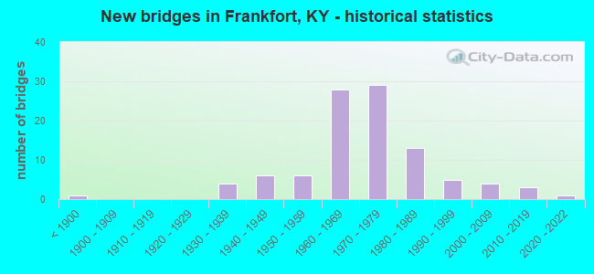
- New bridges - historical statistics
- 1Before 1900
- 41930-1939
- 61940-1949
- 61950-1959
- 281960-1969
- 291970-1979
- 131980-1989
- 51990-1999
- 42000-2009
- 32010-2019
- 12020-2022
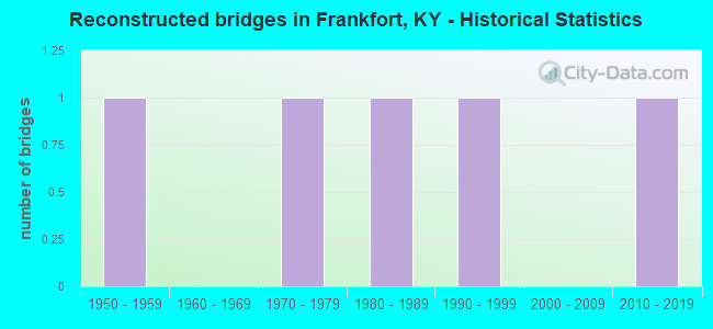
- Reconstructed bridges - Historical Statistics
- 11950-1959
- 01960-1969
- 11970-1979
- 11980-1989
- 11990-1999
- 02000-2009
- 12010-2019
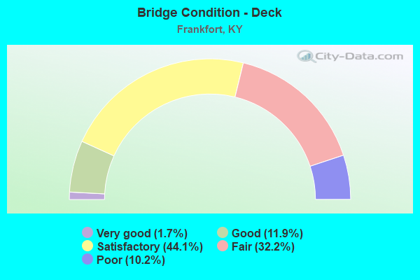
- Bridge Condition - Deck
- 1.7%Very good
- 11.9%Good
- 44.1%Satisfactory
- 32.2%Fair
- 10.2%Poor
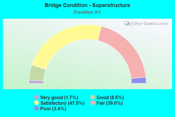
- Bridge Condition - Superstructure
- 1.7%Very good
- 8.5%Good
- 47.5%Satisfactory
- 39.0%Fair
- 3.4%Poor
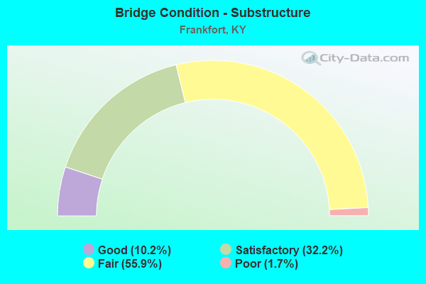
- Bridge Condition - Substructure
- 10.2%Good
- 32.2%Satisfactory
- 55.9%Fair
- 1.7%Poor
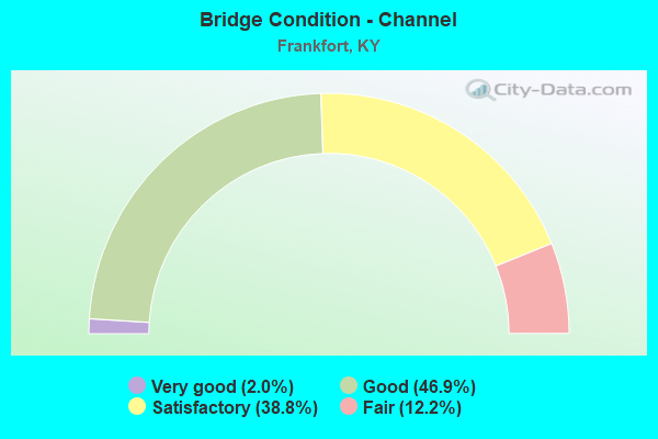
- Bridge Condition - Channel
- 2.0%Very good
- 46.9%Good
- 38.8%Satisfactory
- 12.2%Fair
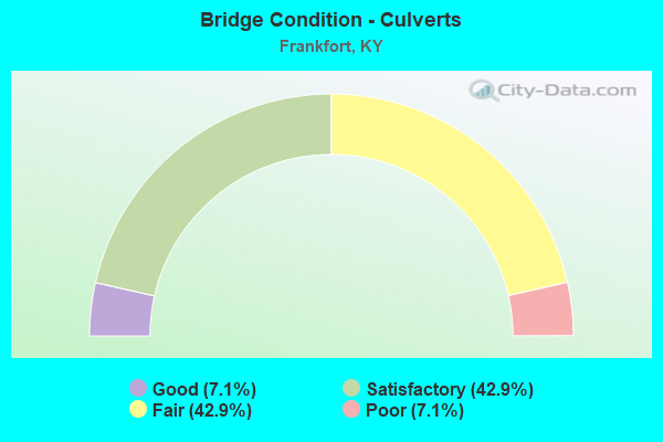
- Bridge Condition - Culverts
- 7.1%Good
- 42.9%Satisfactory
- 42.9%Fair
- 7.1%Poor
Find on map >> Show street view
Structure Number: 37B00084N, Location: 1.7 MI N OF KY 1570 (Lat: 38.242778, Lng: -84.920833), Route carried "on" structure: US 421, Year Built: 1984, Status: Open, Structure Length: 0.77m (2.53ft), Average Daily Traffic: 1,969 (year 2018), Truck Traffic: 11%, Average Future Daily Traffic: 1,634 (year 2038), Design Load: HS 20, Features Intersected: TUCKER CREEK
Minimum Vertical Clearance: 30+ m (98+ ft), Kilometerpoint: 13.580, Lanes on structure: 2, Base Highway Network: Yes, Owner: State Highway Agency, Approaching Roadway Width: 7.5m (24.6ft), Skew: 1 degrees, Material/Design: Concrete, Design/Construction: Culvert, Number Of Spans In Main Unit: 2, Length of Maximum Span: 3.7m (12.1ft)
Condition: Channel: Satisfactory, Culverts: Satisfactory, Operating Rating: 74.8 metric tons, Method Used To Determine Operating Rating: Load Factor (LF), Inventory Rating: 44.7 metric tons, Method Used To Determine Inventory Rating: Load Factor (LF), Structural Evaluation: Equal to present minimum criteria, Waterway Adequacy: Equal to present desirable criteria, Approach Roadway Alignment: Equal to present desirable criteria, Designated Inspection Frequency: Every 24 months, Inspection Date: July 2020
Find on map >> Show street view
Structure Number: 37B00085N, Location: 1.85 MI N OF KY 1570 (Lat: 38.245278, Lng: -84.921389), Route carried "on" structure: US 421, Year Built: 1984, Status: Posted for load, Structure Length: 3.51m (11.52ft), Average Daily Traffic: 1,969 (year 2018), Truck Traffic: 11%, Average Future Daily Traffic: 1,634 (year 2038), Design Load: HS 20, Features Intersected: STONEY CREEK
Minimum Vertical Clearance: 30+ m (98+ ft), Kilometerpoint: 13.852, Lanes on structure: 2, Base Highway Network: Yes, Owner: State Highway Agency, Approaching Roadway Width: 7.6m (24.9ft), Skew: 5 degrees, Material/Design: Concrete, Design/Construction: Culvert, Number Of Spans In Main Unit: 4, Length of Maximum Span: 8.4m (27.6ft)
Condition: Channel: Fair, Culverts: Fair, Operating Rating: 39.0 metric tons, Method Used To Determine Operating Rating: Field evaluation and documented engineering judgment, Inventory Rating: 18.1 metric tons, Method Used To Determine Inventory Rating: Field evaluation and documented engineering judgment, Structural Evaluation: Somewhat better than minimum adequacy, Waterway Adequacy: Better than present minimum criteria, Approach Roadway Alignment: Equal to present desirable criteria, Bridge Posting: Required (Relationship of Operating Rating to Maximum Legal Load: > 39.9% below), Designated Inspection Frequency: Every 24 months, Inspection Date: July 2020
Find on map >> Show street view
Structure Number: 37B00089N, Location: 0.2 MI S OF HOLMES ST (Lat: 38.216944, Lng: -84.855833), Route carried "on" structure: US 127, Year Built: 1976, Status: Open, Structure Length: 1.26m (4.13ft), Average Daily Traffic: 14,530 (year 2019), Truck Traffic: 13%, Average Future Daily Traffic: 13,658 (year 2039), Design Load: HS 20+Mod, Features Intersected: OLD RAILROAD TUNNEL
Minimum Vertical Clearance: 30+ m (98+ ft), Kilometerpoint: 17.222, Lanes on structure: 4, Base Highway Network: Yes, Owner: State Highway Agency, Approaching Roadway Width: 20.4m (66.9ft), Skew: 35 degrees, Material/Design: Steel, Design/Construction: Culvert, Number Of Spans In Main Unit: 1, Length of Maximum Span: 12.6m (41.3ft)
Condition: Culverts: Satisfactory, Operating Rating: 97.2 metric tons, Method Used To Determine Operating Rating: Load and Resistance Factor Rating (LRFR) rating reported by rating factor(RF) method using HL-93 loadings, Inventory Rating: 97.2 metric tons, Method Used To Determine Inventory Rating: Load and Resistance Factor Rating (LRFR) rating reported by rating factor(RF) method using HL-93 loadings, Structural Evaluation: Equal to present minimum criteria, Approach Roadway Alignment: Equal to present desirable criteria, Designated Inspection Frequency: Every 24 months, Inspection Date: August 2020
Find on map >> Show street view
Structure Number: 37B00090N, Location: 1.0 MI N OF US 60 (Lat: 38.195000, Lng: -84.894722), Route carried "on" structure: US 127, Year Built: 1989, Status: Open, Structure Length: 2.09m (6.86ft), Average Daily Traffic: 13,067 (year 2019), Truck Traffic: 13%, Average Future Daily Traffic: 12,282 (year 2039), Design Load: HS 20, Features Intersected: KY 3505 (DEVILS HOLLOW)
Minimum Vertical Clearance: 30+ m (98+ ft), Kilometerpoint: 11.439, Lanes on structure: 4, Lanes under structure: 2, Base Highway Network: Yes, Owner: State Highway Agency, Approaching Roadway Width: 22.2m (72.8ft), Skew: 22 degrees, Material/Design: Prestressed concrete, Design/Construction: Box Beam or Girders - Single/Spread, Number Of Spans In Main Unit: 1, Length of Maximum Span: 20.3m (66.6ft), Curb-To-Curb Width: 26.9m (88.3ft), Out-to-Out Width: 27.9m (91.5ft)
Condition: Deck: Satisfactory, Superstructure: Satisfactory, Substructure: Satisfactory, Operating Rating: 90.9 metric tons, Method Used To Determine Operating Rating: Load Factor (LF), Inventory Rating: 54.5 metric tons, Method Used To Determine Inventory Rating: Load Factor (LF), Structural Evaluation: Equal to present minimum criteria, Deck Geometry: Superior to present desirable criteria, Underclear: Meets minimum limits, Approach Roadway Alignment: Equal to present desirable criteria, Designated Inspection Frequency: Every 24 months, Inspection Date: August 2020, Deck Structure Type: Concrete Cast-file-Place, Wearing Surface/Protective System: Wearing Surface: Monolithic Concrete, Deck Protection: Epoxy Coated Reinforcing
Find on map >> Show street view
Structure Number: 37B00091N, Location: 0.35 MI S OF KY 1211 (Lat: 38.208611, Lng: -84.890000), Route carried "on" structure: US 127, Year Built: 1989, Status: Open, Structure Length: 10.35m (33.96ft), Average Daily Traffic: 13,277 (year 2018), Truck Traffic: 13%, Average Future Daily Traffic: 12,480 (year 2038), Design Load: HS 20, Features Intersected: RJC RR, BENSON VALLEY RD
Minimum Vertical Clearance: 30+ m (98+ ft), Kilometerpoint: 13.192, Lanes on structure: 4, Lanes under structure: 2, Base Highway Network: Yes, Owner: State Highway Agency, Approaching Roadway Width: 25.3m (83.0ft), Skew: 34 degrees, Material/Design: Prestressed concrete continuous, Design/Construction: Stringer/Multi-beam, Number Of Spans In Main Unit: 4, Length of Maximum Span: 27.1m (88.9ft), Curb-To-Curb Width: 24.5m (80.4ft), Out-to-Out Width: 26.3m (86.3ft)
Condition: Deck: Satisfactory, Superstructure: Satisfactory, Substructure: Fair, Operating Rating: 71.0 metric tons, Method Used To Determine Operating Rating: Load Factor (LF), Inventory Rating: 42.6 metric tons, Method Used To Determine Inventory Rating: Load Factor (LF), Structural Evaluation: Somewhat better than minimum adequacy, Deck Geometry: Superior to present desirable criteria, Underclear: High priority of corrective action, Approach Roadway Alignment: Equal to present desirable criteria, Designated Inspection Frequency: Every 24 months, Inspection Date: August 2020, Deck Structure Type: Concrete Cast-file-Place, Wearing Surface/Protective System: Wearing Surface: Monolithic Concrete, Deck Protection: Epoxy Coated Reinforcing
Find on map >> Show street view
Structure Number: 37B00092N, Location: 0.1 MI S OF US 421 (Lat: 38.206944, Lng: -84.885833), Route carried "on" structure: US 127, Year Built: 1989, Status: Open, Structure Length: 13.33m (43.73ft), Average Daily Traffic: 13,277 (year 2018), Truck Traffic: 13%, Average Future Daily Traffic: 12,480 (year 2038), Design Load: HS 20, Features Intersected: BENSON CREEK
Minimum Vertical Clearance: 30+ m (98+ ft), Kilometerpoint: 13.591, Lanes on structure: 4, Base Highway Network: Yes, Owner: State Highway Agency, Approaching Roadway Width: 21.9m (71.9ft), Skew: 34 degrees, Material/Design: Steel continuous, Design/Construction: Stringer/Multi-beam, Number Of Spans In Main Unit: 3, Length of Maximum Span: 54.9m (180.1ft), Curb-To-Curb Width: 21.9m (71.9ft), Out-to-Out Width: 27.8m (91.2ft)
Condition: Deck: Satisfactory, Superstructure: Good, Substructure: Satisfactory, Channel: Good, Operating Rating: 58.7 metric tons, Method Used To Determine Operating Rating: Load Factor (LF), Inventory Rating: 35.2 metric tons, Method Used To Determine Inventory Rating: Load Factor (LF), Structural Evaluation: Equal to present minimum criteria, Deck Geometry: Superior to present desirable criteria, Waterway Adequacy: Equal to present desirable criteria, Approach Roadway Alignment: Equal to present desirable criteria, Designated Inspection Frequency: Every 24 months, Inspection Date: August 2020, Deck Structure Type: Concrete Cast-file-Place, Wearing Surface/Protective System: Wearing Surface: Monolithic Concrete, Deck Protection: Epoxy Coated Reinforcing
Find on map >> Show street view
Structure Number: 37B00093R, Location: 0.2 MI N OF KY 1211 (Lat: 38.203333, Lng: -84.880833), Route carried "on" structure: US 127, Year Built: 1989, Status: Open, Structure Length: 23.33m (76.54ft), Average Daily Traffic: 3,490 (year 2020), Truck Traffic: 13%, Average Future Daily Traffic: 3,281 (year 2040), Design Load: HS 20, Features Intersected: KENTUCKY RIVER
Minimum Vertical Clearance: 30+ m (98+ ft), Kilometerpoint: 14.185, Lanes on structure: 2, Base Highway Network: Yes, Owner: State Highway Agency, Approaching Roadway Width: 9.8m (32.2ft), Navigation Control: Yes ( Vertical Clearance: 16.5m (54.1ft), Horizontal Clearance: 83.2m (273.0ft)), Material/Design: Steel continuous, Design/Construction: Stringer/Multi-beam, Number Of Spans In Main Unit: 3, Number Of Approach Spans: 1, Length of Maximum Span: 88.4m (290.0ft), Curb-To-Curb Width: 9.8m (32.2ft), Out-to-Out Width: 10.5m (34.4ft)
Condition: Deck: Satisfactory, Superstructure: Satisfactory, Substructure: Satisfactory, Channel: Good, Operating Rating: 57.7 metric tons, Method Used To Determine Operating Rating: Load Factor (LF), Inventory Rating: 34.6 metric tons, Method Used To Determine Inventory Rating: Load Factor (LF), Structural Evaluation: Equal to present minimum criteria, Deck Geometry: Meets minimum limits, Waterway Adequacy: Equal to present desirable criteria, Approach Roadway Alignment: Equal to present minimum criteria, Designated Inspection Frequency: Every 24 months, Underwater Inspection Frequency: Every 60 months, Inspection Date: August 2020, Underwater Inspection Date: July 2018, Deck Structure Type: Concrete Cast-file-Place, Wearing Surface/Protective System: Wearing Surface: Monolithic Concrete, Deck Protection: Epoxy Coated Reinforcing
Find on map >> Show street view
Structure Number: 37B00094L, Location: 0.2 MI N OF KY 1211 (Lat: 38.204444, Lng: -84.880278), Route carried "on" structure: US 127, Year Built: 1989, Status: Open, Structure Length: 23.33m (76.54ft), Average Daily Traffic: 3,490 (year 2020), Truck Traffic: 13%, Average Future Daily Traffic: 3,281 (year 2040), Design Load: HS 20, Features Intersected: KENTUCKY RIVER
Minimum Vertical Clearance: 30+ m (98+ ft), Kilometerpoint: 14.296, Lanes on structure: 2, Base Highway Network: Yes, Owner: State Highway Agency, Approaching Roadway Width: 9.8m (32.2ft), Navigation Control: Yes ( Vertical Clearance: 16.5m (54.1ft), Horizontal Clearance: 83.2m (273.0ft)), Material/Design: Steel continuous, Design/Construction: Stringer/Multi-beam, Number Of Spans In Main Unit: 3, Number Of Approach Spans: 1, Length of Maximum Span: 88.4m (290.0ft), Curb or Sidewalk Widths: Left: 1.7m (5.6ft), Right: 0.0m, Curb-To-Curb Width: 9.8m (32.2ft), Out-to-Out Width: 12.5m (41.0ft)
Condition: Deck: Satisfactory, Superstructure: Satisfactory, Substructure: Good, Channel: Good, Operating Rating: 52.1 metric tons, Method Used To Determine Operating Rating: Load Factor (LF), Inventory Rating: 31.2 metric tons, Method Used To Determine Inventory Rating: Load Factor (LF), Structural Evaluation: Equal to present minimum criteria, Deck Geometry: Meets minimum limits, Waterway Adequacy: Equal to present desirable criteria, Approach Roadway Alignment: Equal to present minimum criteria, Designated Inspection Frequency: Every 24 months, Underwater Inspection Frequency: Every 60 months, Inspection Date: August 2020, Underwater Inspection Date: July 2018, Deck Structure Type: Concrete Cast-file-Place, Wearing Surface/Protective System: Wearing Surface: Monolithic Concrete, Deck Protection: Epoxy Coated Reinforcing
Find on map >> Show street view
Structure Number: 37B00096N, Location: 0.7 MI N OF KY 420 (Lat: 38.158333, Lng: -84.893611), Route carried "on" structure: US 127, Year Built: 1992, Status: Open, Structure Length: 8.44m (27.69ft), Average Daily Traffic: 21,100 (year 2009), Truck Traffic: 12%, Average Future Daily Traffic: 19,834 (year 2029), Design Load: HS 25 or greater, Features Intersected: I-64
Minimum Vertical Clearance: 30+ m (98+ ft), Kilometerpoint: 7.137, Lanes on structure: 6, Lanes under structure: 6, Base Highway Network: Yes, Owner: State Highway Agency, Approaching Roadway Width: 28.0m (91.9ft), Skew: 30 degrees, Material/Design: Prestressed concrete continuous, Design/Construction: Stringer/Multi-beam, Number Of Spans In Main Unit: 4, Length of Maximum Span: 27.9m (91.5ft), Curb-To-Curb Width: 28.0m (91.9ft), Out-to-Out Width: 33.9m (111.2ft)
Condition: Deck: Satisfactory, Superstructure: Satisfactory, Substructure: Satisfactory, Operating Rating: 99.8 metric tons, Method Used To Determine Operating Rating: Load Factor (LF), Inventory Rating: 63.2 metric tons, Method Used To Determine Inventory Rating: Load Factor (LF), Structural Evaluation: Equal to present minimum criteria, Deck Geometry: Superior to present desirable criteria, Underclear: Equal to present minimum criteria, Approach Roadway Alignment: Equal to present desirable criteria, Designated Inspection Frequency: Every 24 months, Inspection Date: August 2020, Deck Structure Type: Concrete Cast-file-Place, Wearing Surface/Protective System: Wearing Surface: Monolithic Concrete, Deck Protection: Epoxy Coated Reinforcing
Find on map >> Show street view
Structure Number: 37B00097N, Location: 0.2 MI W OF KY 1665 (Lat: 38.161944, Lng: -84.955833), Route carried "on" structure: US 60, Year Built: 1991, Status: Open, Structure Length: 5.87m (19.26ft), Average Daily Traffic: 5,250 (year 2018), Truck Traffic: 9%, Average Future Daily Traffic: 4,357 (year 2038), Design Load: HS 25 or greater, Features Intersected: S BENSON CREEK
Minimum Vertical Clearance: 30+ m (98+ ft), Kilometerpoint: 4.418, Lanes on structure: 2, Base Highway Network: Yes, Owner: State Highway Agency, Approaching Roadway Width: 11.0m (36.1ft), Material/Design: Prestressed concrete continuous, Design/Construction: Stringer/Multi-beam, Number Of Spans In Main Unit: 5, Length of Maximum Span: 11.6m (38.1ft), Curb-To-Curb Width: 12.2m (40.0ft), Out-to-Out Width: 13.2m (43.3ft)
Condition: Deck: Satisfactory, Superstructure: Satisfactory, Substructure: Fair, Channel: Good, Operating Rating: 76.3 metric tons, Method Used To Determine Operating Rating: Load Factor (LF), Inventory Rating: 45.8 metric tons, Method Used To Determine Inventory Rating: Load Factor (LF), Structural Evaluation: Somewhat better than minimum adequacy, Deck Geometry: Somewhat better than minimum adequacy, Waterway Adequacy: Equal to present desirable criteria, Approach Roadway Alignment: Equal to present desirable criteria, Designated Inspection Frequency: Every 24 months, Inspection Date: August 2020, Deck Structure Type: Concrete Cast-file-Place, Wearing Surface/Protective System: Wearing Surface: Monolithic Concrete, Deck Protection: Epoxy Coated Reinforcing
Find on map >> Show street view
Structure Number: 37B00104N, Location: 0.1 MI S OF US 421 (Lat: 38.247778, Lng: -84.928611), Route carried "on" structure: State highway 1665, Year Built: 2009, Status: Open, Structure Length: 1.77m (5.81ft), Average Daily Traffic: 155 (year 2018), Average Future Daily Traffic: 136 (year 2038), Features Intersected: STONEY CREEK
Minimum Vertical Clearance: 30+ m (98+ ft), Kilometerpoint: 19.002, Lanes on structure: 2, Owner: State Highway Agency, Approaching Roadway Width: 5.5m (18.0ft), Skew: 3 degrees, Material/Design: Prestressed concrete, Design/Construction: Box Beam or Girders - Single/Spread, Number Of Spans In Main Unit: 1, Length of Maximum Span: 17.2m (56.4ft), Curb-To-Curb Width: 6.1m (20.0ft), Out-to-Out Width: 6.6m (21.7ft)
Condition: Deck: Good, Superstructure: Very good, Substructure: Good, Channel: Satisfactory, Operating Rating: 84.3 metric tons, Method Used To Determine Operating Rating: Load and Resistance Factor (LRFR), Inventory Rating: 65.0 metric tons, Method Used To Determine Inventory Rating: Load and Resistance Factor (LRFR), Structural Evaluation: Better than present minimum criteria, Deck Geometry: Meets minimum limits, Waterway Adequacy: Better than present minimum criteria, Approach Roadway Alignment: Equal to present minimum criteria, Designated Inspection Frequency: Every 24 months, Inspection Date: July 2020, Deck Structure Type: Concrete Cast-file-Place, Wearing Surface/Protective System: Wearing Surface: Monolithic Concrete, Deck Protection: Epoxy Coated Reinforcing
Find on map >> Show street view
Structure Number: 37B00110N, Location: 0.2 MI S OF KY 676 (Lat: 38.166667, Lng: -84.878056), Route carried "on" structure: State highway 420, Year Built: 2020, Status: Open, Structure Length: 1.34m (4.40ft), Average Daily Traffic: 3,181 (year 2020), Average Future Daily Traffic: 2,958 (year 2040), Design Load: Greater than HL93, Features Intersected: CEDAR RUN
Minimum Vertical Clearance: 30+ m (98+ ft), Kilometerpoint: 3.141, Lanes on structure: 2, Owner: State Highway Agency, Approaching Roadway Width: 7.6m (24.9ft), Skew: 4 degrees, Material/Design: Concrete, Design/Construction: Culvert, Number Of Spans In Main Unit: 2, Length of Maximum Span: 6.5m (21.3ft)
Condition: Channel: Very good, Culverts: Good, Operating Rating: 52.8 metric tons, Method Used To Determine Operating Rating: Load and Resistance Factor Rating (LRFR) rating reported by rating factor(RF) method using HL-93 loadings, Inventory Rating: 52.5 metric tons, Method Used To Determine Inventory Rating: Load and Resistance Factor Rating (LRFR) rating reported by rating factor(RF) method using HL-93 loadings, Structural Evaluation: Better than present minimum criteria, Waterway Adequacy: Equal to present desirable criteria, Approach Roadway Alignment: Equal to present desirable criteria, Designated Inspection Frequency: Every 24 months, Inspection Date: September 2020
Find on map >> Show street view
Structure Number: 37C00001N, Location: 0.85 MI E OF KY 1262 (Lat: 38.291667, Lng: -84.788056), Route carried "on" structure: County highway 1014, Year Built: 1979, Status: Open, Structure Length: 1.01m (3.31ft), Average Daily Traffic: 69 (year 2006), Average Future Daily Traffic: 2,026 (year 2026), Design Load: HS 20, Features Intersected: TRIB SULPHUR LICK CREEK, Facility Carried by Structure: SULPHUR LICK RD
Minimum Vertical Clearance: 30+ m (98+ ft), Kilometerpoint: 1.382, Lanes on structure: 2, Owner: County Highway Agency, Approaching Roadway Width: 6.4m (21.0ft), Skew: 1 degrees, Material/Design: Prestressed concrete, Design/Construction: Box Beam or Girders - Multiple, Number Of Spans In Main Unit: 1, Length of Maximum Span: 9.8m (32.2ft), Curb-To-Curb Width: 6.1m (20.0ft), Out-to-Out Width: 6.4m (21.0ft)
Condition: Deck: Good, Superstructure: Satisfactory, Substructure: Satisfactory, Channel: Satisfactory, Operating Rating: 85.1 metric tons, Method Used To Determine Operating Rating: Load Factor (LF), Inventory Rating: 51.1 metric tons, Method Used To Determine Inventory Rating: Load Factor (LF), Structural Evaluation: Equal to present minimum criteria, Deck Geometry: Somewhat better than minimum adequacy, Waterway Adequacy: Superior to present desirable criteria, Approach Roadway Alignment: Equal to present desirable criteria, Designated Inspection Frequency: Every 24 months, Inspection Date: May 2020, Deck Structure Type: Concrete Precast Panels, Wearing Surface/Protective System: Wearing Surface: Bituminous
Find on map >> Show street view
Structure Number: 37C00008N, Location: 0.8 MI E OF KY 151 (Lat: 38.129444, Lng: -84.964167), Route carried "on" structure: County highway 1223, Year Built: 1975, Status: Open, Structure Length: 2.07m (6.79ft), Average Daily Traffic: 137 (year 2006), Average Future Daily Traffic: 2,026 (year 2026), Design Load: HS 20, Features Intersected: S BENSON CREEK, Facility Carried by Structure: S BENSON RD
Minimum Vertical Clearance: 30+ m (98+ ft), Kilometerpoint: 2.391, Lanes on structure: 2, Owner: County Highway Agency, Approaching Roadway Width: 5.8m (19.0ft), Material/Design: Prestressed concrete, Design/Construction: Box Beam or Girders - Multiple, Number Of Spans In Main Unit: 1, Length of Maximum Span: 19.8m (65.0ft), Curb-To-Curb Width: 7.0m (23.0ft), Out-to-Out Width: 7.3m (24.0ft)
Condition: Deck: Satisfactory, Superstructure: Satisfactory, Substructure: Satisfactory, Channel: Satisfactory, Operating Rating: 74.8 metric tons, Method Used To Determine Operating Rating: Load Factor (LF), Inventory Rating: 44.9 metric tons, Method Used To Determine Inventory Rating: Load Factor (LF), Structural Evaluation: Equal to present minimum criteria, Deck Geometry: Meets minimum limits, Waterway Adequacy: Superior to present desirable criteria, Approach Roadway Alignment: Equal to present minimum criteria, Designated Inspection Frequency: Every 24 months, Inspection Date: May 2020, Deck Structure Type: Concrete Precast Panels, Wearing Surface/Protective System: Wearing Surface: Monolithic Concrete
Find on map >> Show street view
Structure Number: 37C00011N, Location: 230 FT W OF KY 1665 (Lat: 38.160000, Lng: -84.953889), Route carried "on" structure: County highway 1231, Year Built: 1945, Status: Posted for load, Structure Length: 1.37m (4.49ft), Average Daily Traffic: 275 (year 2006), Average Future Daily Traffic: 346 (year 2026), Features Intersected: S BENSON CREEK, Facility Carried by Structure: BRIDGEPORT RD
Minimum Vertical Clearance: 30+ m (98+ ft), Kilometerpoint: 1.360, Lanes on structure: 2, Owner: County Highway Agency, Approaching Roadway Width: 5.8m (19.0ft), Material/Design: Concrete, Design/Construction: Slab, Number Of Spans In Main Unit: 2, Length of Maximum Span: 6.4m (21.0ft), Curb or Sidewalk Widths: Left: 0.2m (0.7ft), Right: 0.8m (2.6ft), Curb-To-Curb Width: 8.4m (27.6ft), Out-to-Out Width: 10.1m (33.1ft)
Condition: Deck: Fair, Superstructure: Fair, Substructure: Fair, Channel: Satisfactory, Operating Rating: 16.3 metric tons, Method Used To Determine Operating Rating: Field evaluation and documented engineering judgment, Inventory Rating: 16.3 metric tons, Method Used To Determine Inventory Rating: Field evaluation and documented engineering judgment, Structural Evaluation: Somewhat better than minimum adequacy, Deck Geometry: Somewhat better than minimum adequacy, Waterway Adequacy: Superior to present desirable criteria, Approach Roadway Alignment: Equal to present desirable criteria, Bridge Posting: Required (Relationship of Operating Rating to Maximum Legal Load: > 39.9% below), Designated Inspection Frequency: Every 24 months, Inspection Date: May 2020, Deck Structure Type: Concrete Cast-file-Place, Wearing Surface/Protective System: Wearing Surface: Bituminous
Find on map >> Show street view
Structure Number: 37C00015N, Location: 1.15 MI E OF KY 1665 (Lat: 38.184167, Lng: -84.941111), Route carried "on" structure: County highway 1237, Year Built: 1959, Status: Posted for load, Structure Length: 4.85m (15.91ft), Average Daily Traffic: 103 (year 2006), Average Future Daily Traffic: 130 (year 2026), Features Intersected: S BENSON CREEK, Facility Carried by Structure: PEA RIDGE RD
Minimum Vertical Clearance: 30+ m (98+ ft), Kilometerpoint: 1.817, Lanes on structure: 2, Owner: County Highway Agency, Approaching Roadway Width: 5.5m (18.0ft), Skew: 3 degrees, Material/Design: Concrete, Design/Construction: Tee Beam, Number Of Spans In Main Unit: 3, Length of Maximum Span: 16.2m (53.1ft), Curb or Sidewalk Widths: Left: 0.3m (1.0ft), Right: 0.3m (1.0ft), Curb-To-Curb Width: 7.3m (24.0ft), Out-to-Out Width: 8.6m (28.2ft)
Condition: Deck: Satisfactory, Superstructure: Fair, Substructure: Fair, Channel: Good, Operating Rating: 16.3 metric tons, Method Used To Determine Operating Rating: Field evaluation and documented engineering judgment, Inventory Rating: 16.3 metric tons, Method Used To Determine Inventory Rating: Field evaluation and documented engineering judgment, Structural Evaluation: Somewhat better than minimum adequacy, Deck Geometry: Somewhat better than minimum adequacy, Waterway Adequacy: Superior to present desirable criteria, Approach Roadway Alignment: Equal to present desirable criteria, Bridge Posting: Required (Relationship of Operating Rating to Maximum Legal Load: > 39.9% below), Designated Inspection Frequency: Every 24 months, Inspection Date: May 2020, Deck Structure Type: Concrete Cast-file-Place, Wearing Surface/Protective System: Wearing Surface: Bituminous
Find on map >> Show street view
Structure Number: 37C00022N, Location: 1.45 MI N OF US 421 (Lat: 38.247500, Lng: -84.913056), Route carried "on" structure: County highway 1314, Year Built: 1974, Status: Open, Structure Length: 2.53m (8.30ft), Average Daily Traffic: 103 (year 2006), Average Future Daily Traffic: 2,026 (year 2026), Design Load: HS 20, Features Intersected: STONY CREEK, Facility Carried by Structure: HARVIELAND RD
Minimum Vertical Clearance: 30+ m (98+ ft), Kilometerpoint: 3.811, Lanes on structure: 2, Owner: County Highway Agency, Approaching Roadway Width: 6.6m (21.7ft), Skew: 4 degrees, Material/Design: Prestressed concrete, Design/Construction: Box Beam or Girders - Multiple, Number Of Spans In Main Unit: 1, Length of Maximum Span: 24.4m (80.1ft), Curb-To-Curb Width: 6.9m (22.6ft), Out-to-Out Width: 7.3m (24.0ft)
Condition: Deck: Fair, Superstructure: Fair, Substructure: Fair, Channel: Fair, Operating Rating: 76.7 metric tons, Method Used To Determine Operating Rating: Load Factor (LF), Inventory Rating: 46.1 metric tons, Method Used To Determine Inventory Rating: Load Factor (LF), Structural Evaluation: Somewhat better than minimum adequacy, Deck Geometry: Meets minimum limits, Waterway Adequacy: Meets minimum limits, Approach Roadway Alignment: Equal to present minimum criteria, Designated Inspection Frequency: Every 24 months, Inspection Date: May 2020, Deck Structure Type: Concrete Precast Panels, Wearing Surface/Protective System: Wearing Surface: Bituminous, Membrane: Preformed Fabric
Find on map >> Show street view
Structure Number: 37C00027N, Location: 0.75 MI S OF US 421 (Lat: 38.176667, Lng: -84.799722), Route carried "on" structure: County highway 1117, Year Built: 1978, Status: Open, Structure Length: 2.01m (6.59ft), Average Daily Traffic: 2,567 (year 2019), Average Future Daily Traffic: 2,387 (year 2039), Design Load: HS 20, Features Intersected: RJ CORMAN RAILROAD, Facility Carried by Structure: CHENAULT RD
Minimum Vertical Clearance: 30+ m (98+ ft), Kilometerpoint: 1.481, Lanes on structure: 2, Owner: County Highway Agency, Approaching Roadway Width: 7.3m (24.0ft), Skew: 3 degrees, Material/Design: Prestressed concrete, Design/Construction: Box Beam or Girders - Multiple, Number Of Spans In Main Unit: 1, Length of Maximum Span: 19.4m (63.6ft), Curb or Sidewalk Widths: Left: 0.1m (0.3ft), Right: 0.1m (0.3ft), Curb-To-Curb Width: 7.8m (25.6ft), Out-to-Out Width: 8.2m (26.9ft)
Condition: Deck: Satisfactory, Superstructure: Satisfactory, Substructure: Fair, Operating Rating: 85.5 metric tons, Method Used To Determine Operating Rating: Load Factor (LF), Inventory Rating: 51.3 metric tons, Method Used To Determine Inventory Rating: Load Factor (LF), Structural Evaluation: Somewhat better than minimum adequacy, Deck Geometry: High priority of replacement, Underclear: Meets minimum limits, Approach Roadway Alignment: Equal to present desirable criteria, Designated Inspection Frequency: Every 24 months, Inspection Date: May 2020, Deck Structure Type: Concrete Precast Panels, Wearing Surface/Protective System: Wearing Surface: Bituminous
Find on map >> Show street view
Structure Number: 37C00033N, Location: 0.6 MI S OF US 421 (Lat: 38.208889, Lng: -84.846111), Route carried "on" structure: City street 1002, Year Built: 1975, Status: Posted for load, Structure Length: 2.07m (6.79ft), Average Daily Traffic: 3,389 (year 2020), Average Future Daily Traffic: 3,151 (year 2040), Design Load: HS 20, Features Intersected: OLD F&C RAILROAD, Facility Carried by Structure: SCHENKEL LN
Minimum Vertical Clearance: 30+ m (98+ ft), Kilometerpoint: 3.040, Lanes on structure: 2, Owner: City or Municipal Highway Agency, Approaching Roadway Width: 6.8m (22.3ft), Skew: 1 degrees, Material/Design: Prestressed concrete, Design/Construction: Box Beam or Girders - Multiple, Number Of Spans In Main Unit: 1, Length of Maximum Span: 20.7m (67.9ft), Curb or Sidewalk Widths: Left: 0.1m (0.3ft), Right: 0.1m (0.3ft), Curb-To-Curb Width: 7.0m (23.0ft), Out-to-Out Width: 7.4m (24.3ft)
Condition: Deck: Satisfactory, Superstructure: Fair, Substructure: Fair, Operating Rating: 74.1 metric tons, Method Used To Determine Operating Rating: Load Factor (LF), Inventory Rating: 44.5 metric tons, Method Used To Determine Inventory Rating: Load Factor (LF), Structural Evaluation: Somewhat better than minimum adequacy, Deck Geometry: High priority of replacement, Approach Roadway Alignment: Equal to present desirable criteria, Designated Inspection Frequency: Every 24 months, Inspection Date: May 2020, Deck Structure Type: Concrete Precast Panels, Wearing Surface/Protective System: Wearing Surface: Bituminous
Find on map >> Show street view
Structure Number: 37C00035N, Location: 0.3 MI N OF KY 2820 (Lat: 38.110000, Lng: -84.932222), Route carried "on" structure: Alternate County highway 1220, Year Built: 1976, Status: Posted for load, Structure Length: 1.55m (5.09ft), Average Daily Traffic: 249 (year 2006), Average Future Daily Traffic: 313 (year 2026), Design Load: H 20, Features Intersected: TRIB TO S BENSON CREEK, Facility Carried by Structure: FARMERS LN
Minimum Vertical Clearance: 30+ m (98+ ft), Kilometerpoint: 0.433, Lanes on structure: 2, Owner: County Highway Agency, Approaching Roadway Width: 6.7m (22.0ft), Material/Design: Prestressed concrete, Design/Construction: Box Beam or Girders - Multiple, Number Of Spans In Main Unit: 1, Length of Maximum Span: 15.5m (50.9ft), Curb or Sidewalk Widths: Left: 0.1m (0.3ft), Right: 0.1m (0.3ft), Curb-To-Curb Width: 7.0m (23.0ft), Out-to-Out Width: 7.4m (24.3ft)
Condition: Deck: Satisfactory, Superstructure: Fair, Substructure: Satisfactory, Channel: Fair, Operating Rating: 23.6 metric tons, Method Used To Determine Operating Rating: Load Factor (LF), Inventory Rating: 14.2 metric tons, Method Used To Determine Inventory Rating: Load Factor (LF), Structural Evaluation: Meets minimum limits, Deck Geometry: Meets minimum limits, Waterway Adequacy: Better than present minimum criteria, Approach Roadway Alignment: Equal to present desirable criteria, Bridge Posting: Required (Relationship of Operating Rating to Maximum Legal Load: > 39.9% below), Designated Inspection Frequency: Every 24 months, Inspection Date: May 2020, Deck Structure Type: Concrete Precast Panels, Wearing Surface/Protective System: Wearing Surface: Bituminous
Find on map >> Show street view
Structure Number: 37C00040N, Location: 0.25 MI E OF MILLS LN (Lat: 38.112222, Lng: -84.899722), Route carried "on" structure: Alternate County highway 1241, Year Built: 1993, Status: Posted for load, Structure Length: 0.73m (2.40ft), Average Daily Traffic: 58 (year 2006), Average Future Daily Traffic: 73 (year 2026), Features Intersected: BOONE BRANCH, Facility Carried by Structure: DOVE CREEK RD
Minimum Vertical Clearance: 30+ m (98+ ft), Kilometerpoint: 0.401, Lanes on structure: 2, Owner: County Highway Agency, Approaching Roadway Width: 6.7m (22.0ft), Material/Design: Wood or Timber, Design/Construction: Slab, Number Of Spans In Main Unit: 1, Length of Maximum Span: 6.7m (22.0ft), Curb or Sidewalk Widths: Left: 0.1m (0.3ft), Right: 0.1m (0.3ft), Curb-To-Curb Width: 7.4m (24.3ft), Out-to-Out Width: 7.8m (25.6ft)
Condition: Deck: Good, Superstructure: Satisfactory, Substructure: Fair, Channel: Good, Operating Rating: 51.8 metric tons, Method Used To Determine Operating Rating: Allowable Stress (AS), Inventory Rating: 36.1 metric tons, Method Used To Determine Inventory Rating: Allowable Stress (AS), Structural Evaluation: Somewhat better than minimum adequacy, Deck Geometry: Equal to present minimum criteria, Waterway Adequacy: Superior to present desirable criteria, Approach Roadway Alignment: Equal to present desirable criteria, Bridge Posting: Required (Relationship of Operating Rating to Maximum Legal Load: > 39.9% below), Designated Inspection Frequency: Every 24 months, Inspection Date: May 2020, Deck Structure Type: Wood or Timber, Wearing Surface/Protective System: Wearing Surface: Bituminous, Deck Protection: Other
Find on map >> Show street view
Structure Number: 37C00043N, Location: 150 FT E OF HARVIELAND RD (Lat: 38.247500, Lng: -84.910278), Route carried "on" structure: County highway 1315, Year Built: 1998, Status: Open, Structure Length: 1.10m (3.61ft), Average Daily Traffic: 27 (year 2006), Average Future Daily Traffic: 34 (year 2026), Design Load: HS 25 or greater, Features Intersected: DAVIS BRANCH, Facility Carried by Structure: STONEY CREEK RD
Minimum Vertical Clearance: 30+ m (98+ ft), Kilometerpoint: 0.045, Lanes on structure: 2, Owner: County Highway Agency, Approaching Roadway Width: 6.1m (20.0ft), Skew: 3 degrees, Material/Design: Prestressed concrete, Design/Construction: Box Beam or Girders - Multiple, Number Of Spans In Main Unit: 1, Length of Maximum Span: 11.0m (36.1ft), Curb-To-Curb Width: 6.9m (22.6ft), Out-to-Out Width: 7.4m (24.3ft)
Condition: Deck: Satisfactory, Superstructure: Satisfactory, Substructure: Fair, Channel: Satisfactory, Operating Rating: 79.2 metric tons, Method Used To Determine Operating Rating: Load Factor (LF), Inventory Rating: 47.5 metric tons, Method Used To Determine Inventory Rating: Load Factor (LF), Structural Evaluation: Somewhat better than minimum adequacy, Deck Geometry: Somewhat better than minimum adequacy, Waterway Adequacy: Meets minimum limits, Approach Roadway Alignment: Meets minimum limits, Designated Inspection Frequency: Every 24 months, Inspection Date: May 2020, Deck Structure Type: Concrete Precast Panels, Wearing Surface/Protective System: Wearing Surface: Monolithic Concrete, Deck Protection: Epoxy Coated Reinforcing
Find on map >> Show street view
Structure Number: 37C00046N, Location: 0.8 MI E OF HARVIELAND RD (Lat: 38.249722, Lng: -84.898333), Route carried "on" structure: County highway 1315, Year Built: 2005, Status: Open, Structure Length: 2.38m (7.81ft), Average Daily Traffic: 34 (year 2006), Average Future Daily Traffic: 43 (year 2026), Design Load: HS 25 or greater, Features Intersected: STONEY CREEK, Facility Carried by Structure: STONEY CREEK RD
Minimum Vertical Clearance: 30+ m (98+ ft), Kilometerpoint: 1.238, Lanes on structure: 2, Owner: County Highway Agency, Approaching Roadway Width: 6.1m (20.0ft), Skew: 3 degrees, Material/Design: Prestressed concrete, Design/Construction: Box Beam or Girders - Multiple, Number Of Spans In Main Unit: 1, Length of Maximum Span: 23.8m (78.1ft), Curb-To-Curb Width: 5.7m (18.7ft), Out-to-Out Width: 6.1m (20.0ft)
Condition: Deck: Satisfactory, Superstructure: Satisfactory, Substructure: Fair, Channel: Satisfactory, Operating Rating: 99.8 metric tons, Method Used To Determine Operating Rating: Load Factor (LF), Inventory Rating: 63.0 metric tons, Method Used To Determine Inventory Rating: Load Factor (LF), Structural Evaluation: Somewhat better than minimum adequacy, Deck Geometry: Meets minimum limits, Waterway Adequacy: Equal to present minimum criteria, Approach Roadway Alignment: Equal to present minimum criteria, Length Of Structure Improvement: 0.18m (0.59ft), Designated Inspection Frequency: Every 24 months, Inspection Date: May 2020, Bridge Improvement Cost: $94,000, Total Project Cost: $93,000, Deck Structure Type: Concrete Precast Panels, Wearing Surface/Protective System: Wearing Surface: Bituminous, Membrane: Preformed Fabric, Deck Protection: Epoxy Coated Reinforcing
Find on map >> Show street view
Structure Number: 37C00047N, Location: AT STONEY CREEK RD (Lat: 38.249167, Lng: -84.890000), Route carried "on" structure: County highway 1316, Year Built: 2003, Status: Open, Structure Length: 2.38m (7.81ft), Average Daily Traffic: 26 (year 2006), Average Future Daily Traffic: 2,026 (year 2026), Design Load: HS 25 or greater, Features Intersected: STONEY CREEK, Facility Carried by Structure: N STONEY CREEK RD
Minimum Vertical Clearance: 30+ m (98+ ft), Kilometerpoint: 0.027, Lanes on structure: 2, Owner: County Highway Agency, Approaching Roadway Width: 3.7m (12.1ft), Skew: 1 degrees, Material/Design: Prestressed concrete, Design/Construction: Box Beam or Girders - Multiple, Number Of Spans In Main Unit: 1, Length of Maximum Span: 23.8m (78.1ft), Curb-To-Curb Width: 5.7m (18.7ft), Out-to-Out Width: 6.1m (20.0ft)
Condition: Deck: Satisfactory, Superstructure: Satisfactory, Substructure: Fair, Channel: Fair, Operating Rating: 99.8 metric tons, Method Used To Determine Operating Rating: Load Factor (LF), Inventory Rating: 65.6 metric tons, Method Used To Determine Inventory Rating: Load Factor (LF), Structural Evaluation: Somewhat better than minimum adequacy, Deck Geometry: Meets minimum limits, Waterway Adequacy: Equal to present minimum criteria, Approach Roadway Alignment: Equal to present desirable criteria, Length Of Structure Improvement: 0.18m (0.59ft), Designated Inspection Frequency: Every 24 months, Inspection Date: May 2020, Bridge Improvement Cost: $234,000, Roadway Improvement Cost: $6,000, Total Project Cost: $240,000, Deck Structure Type: Concrete Precast Panels, Wearing Surface/Protective System: Wearing Surface: Bituminous, Membrane: Preformed Fabric, Deck Protection: Epoxy Coated Reinforcing
Find on map >> Show street view
Structure Number: 37C00055N, Location: 0.2 MI W OF KY 1665 (Lat: 38.142222, Lng: -84.953889), Route carried "on" structure: County highway 1044, Year Built: 2005, Status: Open, Structure Length: 2.13m (6.99ft), Average Daily Traffic: 270 (year 2015), Average Future Daily Traffic: 329 (year 2035), Design Load: HS 25 or greater, Features Intersected: S BENSON CREEK, Facility Carried by Structure: DENISON WAY
Minimum Vertical Clearance: 30+ m (98+ ft), Kilometerpoint: 0.327, Lanes on structure: 2, Owner: County Highway Agency, Approaching Roadway Width: 7.0m (23.0ft), Material/Design: Prestressed concrete, Design/Construction: Box Beam or Girders - Multiple, Number Of Spans In Main Unit: 1, Length of Maximum Span: 20.4m (66.9ft), Curb-To-Curb Width: 6.9m (22.6ft), Out-to-Out Width: 7.3m (24.0ft)
Condition: Deck: Good, Superstructure: Good, Substructure: Good, Channel: Good, Operating Rating: 86.7 metric tons, Method Used To Determine Operating Rating: Load Factor (LF), Inventory Rating: 52.1 metric tons, Method Used To Determine Inventory Rating: Load Factor (LF), Structural Evaluation: Better than present minimum criteria, Deck Geometry: Meets minimum limits, Waterway Adequacy: Equal to present desirable criteria, Approach Roadway Alignment: Equal to present desirable criteria, Designated Inspection Frequency: Every 24 months, Inspection Date: May 2020, Deck Structure Type: Concrete Precast Panels, Wearing Surface/Protective System: Wearing Surface: Monolithic Concrete, Deck Protection: Epoxy Coated Reinforcing
Find on map >> Show street view
Structure Number: 37C00056N, Location: 1.8 MI S OF KY 12 (Lat: 38.253606, Lng: -84.912842), Route carried "on" structure: County highway 1314, Year Built: 2017, Status: Open, Structure Length: 1.82m (5.97ft), Average Daily Traffic: 206 (year 2017), Average Future Daily Traffic: 2,037 (year 2037), Design Load: Greater than HL93, Features Intersected: DAVIS BRANCH, Facility Carried by Structure: HARVIELAND RD
Minimum Vertical Clearance: 30+ m (98+ ft), Kilometerpoint: 2.853, Lanes on structure: 2, Owner: County Highway Agency, Approaching Roadway Width: 6.7m (22.0ft), Skew: 3 degrees, Material/Design: Prestressed concrete, Design/Construction: Box Beam or Girders - Multiple, Number Of Spans In Main Unit: 1, Length of Maximum Span: 16.0m (52.5ft), Curb-To-Curb Width: 6.9m (22.6ft), Out-to-Out Width: 7.3m (24.0ft)
Condition: Deck: Very good, Superstructure: Good, Substructure: Good, Channel: Good, Operating Rating: 81.0 metric tons, Method Used To Determine Operating Rating: Load and Resistance Factor Rating (LRFR) rating reported by rating factor(RF) method using HL-93 loadings, Inventory Rating: 62.5 metric tons, Method Used To Determine Inventory Rating: Load and Resistance Factor Rating (LRFR) rating reported by rating factor(RF) method using HL-93 loadings, Structural Evaluation: Better than present minimum criteria, Deck Geometry: Meets minimum limits, Waterway Adequacy: Better than present minimum criteria, Approach Roadway Alignment: Equal to present desirable criteria, Designated Inspection Frequency: Every 24 months, Inspection Date: May 2020, Deck Structure Type: Concrete Precast Panels, Wearing Surface/Protective System: Wearing Surface: Bituminous, Membrane: Preformed Fabric, Deck Protection: Epoxy Coated Reinforcing
Find on map >> Show street view
Structure Number: 120B00012N, Location: .90 MI S OF JCT KY 1681 (Lat: 38.128611, Lng: -84.823056), Route carried "on" structure: State highway 1659, Year Built: 1951, Status: Posted for load, Structure Length: 2.32m (7.61ft), Average Daily Traffic: 807 (year 2019), Average Future Daily Traffic: 710 (year 2039), Design Load: H 15, Features Intersected: GLENNS CREEK
Minimum Vertical Clearance: 30+ m (98+ ft), Kilometerpoint: 14.378, Lanes on structure: 2, Owner: State Highway Agency, Approaching Roadway Width: 5.8m (19.0ft), Skew: 3 degrees, Material/Design: Concrete, Design/Construction: Tee Beam, Number Of Spans In Main Unit: 2, Length of Maximum Span: 10.4m (34.1ft), Curb or Sidewalk Widths: Left: 0.3m (1.0ft), Right: 0.3m (1.0ft), Curb-To-Curb Width: 5.8m (19.0ft), Out-to-Out Width: 8.0m (26.2ft)
Condition: Deck: Fair, Superstructure: Satisfactory, Substructure: Satisfactory, Channel: Satisfactory, Operating Rating: 43.6 metric tons, Method Used To Determine Operating Rating: Load Factor (LF), Inventory Rating: 26.1 metric tons, Method Used To Determine Inventory Rating: Load Factor (LF), Structural Evaluation: Equal to present minimum criteria, Deck Geometry: High priority of replacement, Waterway Adequacy: Better than present minimum criteria, Approach Roadway Alignment: Equal to present minimum criteria, Bridge Posting: Required (Relationship of Operating Rating to Maximum Legal Load: 30.0 - 39.9% below), Designated Inspection Frequency: Every 24 months, Inspection Date: November 2020, Deck Structure Type: Concrete Cast-file-Place, Wearing Surface/Protective System: Wearing Surface: Bituminous
Find on map >> Show street view
Structure Number: 120B00013N, Location: 5FT S OF JCT KY 1681 (Lat: 38.140278, Lng: -84.825000), Route carried "on" structure: State highway 1659, Year Built: 1961, Year Reconstructed: 1997, Status: Posted for load, Structure Length: 0.73m (2.40ft), Average Daily Traffic: 807 (year 2019), Average Future Daily Traffic: 710 (year 2039), Design Load: H 20, Features Intersected: BRANCH OF GLENN CREEK
Minimum Vertical Clearance: 30+ m (98+ ft), Kilometerpoint: 15.841, Lanes on structure: 2, Owner: State Highway Agency, Approaching Roadway Width: 5.5m (18.0ft), Material/Design: Prestressed concrete, Design/Construction: Box Beam or Girders - Multiple, Number Of Spans In Main Unit: 1, Length of Maximum Span: 6.5m (21.3ft), Curb or Sidewalk Widths: Left: 0.2m (0.7ft), Right: 0.2m (0.7ft), Curb-To-Curb Width: 9.5m (31.2ft), Out-to-Out Width: 10.1m (33.1ft)
Condition: Deck: Good, Superstructure: Satisfactory, Substructure: Satisfactory, Channel: Fair, Operating Rating: 62.1 metric tons, Method Used To Determine Operating Rating: Load Factor (LF), Inventory Rating: 37.3 metric tons, Method Used To Determine Inventory Rating: Load Factor (LF), Structural Evaluation: Equal to present minimum criteria, Deck Geometry: Equal to present minimum criteria, Waterway Adequacy: Better than present minimum criteria, Approach Roadway Alignment: Somewhat better than minimum adequacy, Bridge Posting: Required (Relationship of Operating Rating to Maximum Legal Load: 10.0 - 19.9% below), Designated Inspection Frequency: Every 24 months, Inspection Date: November 2020, Deck Structure Type: Concrete Precast Panels, Wearing Surface/Protective System: Wearing Surface: Bituminous, Membrane: Preformed Fabric
Find on map >> Show street view
Structure Number: 120B00020N, Location: 500FT E. OF FRANKLIN C.L. (Lat: 38.172778, Lng: -84.781389), Route carried "on" structure: County highway 1303, Year Built: 1972, Status: Open, Structure Length: 8.60m (28.22ft), Average Daily Traffic: 301 (year 2014), Average Future Daily Traffic: 2,034 (year 2034), Design Load: H 20, Features Intersected: I 64, Facility Carried by Structure: DUCKERS RD
Minimum Vertical Clearance: 30+ m (98+ ft), Kilometerpoint: 0.972, Lanes on structure: 2, Lanes under structure: 4, Owner: State Highway Agency, Approaching Roadway Width: 5.8m (19.0ft), Material/Design: Concrete continuous, Design/Construction: Tee Beam, Number Of Spans In Main Unit: 4, Length of Maximum Span: 27.1m (88.9ft), Curb or Sidewalk Widths: Left: 0.2m (0.7ft), Right: 0.2m (0.7ft), Curb-To-Curb Width: 8.5m (27.9ft), Out-to-Out Width: 9.4m (30.8ft)
Condition: Deck: Satisfactory, Superstructure: Satisfactory, Substructure: Good, Operating Rating: 56.4 metric tons, Method Used To Determine Operating Rating: Load Factor (LF), Inventory Rating: 33.8 metric tons, Method Used To Determine Inventory Rating: Load Factor (LF), Structural Evaluation: Equal to present minimum criteria, Deck Geometry: Equal to present minimum criteria, Underclear: Somewhat better than minimum adequacy, Approach Roadway Alignment: Better than present minimum criteria, Designated Inspection Frequency: Every 24 months, Inspection Date: November 2020, Deck Structure Type: Concrete Cast-file-Place, Wearing Surface/Protective System: Wearing Surface: Monolithic Concrete
Find on map >> Show street view
Structure Number: 120B00034N, Location: 1.5 MI W OF JCT KY 1685 (Lat: 38.155278, Lng: -84.771667), Route carried "on" structure: State highway 1681, Year Built: 1984, Status: Open, Structure Length: 1.37m (4.49ft), Average Daily Traffic: 689 (year 2018), Truck Traffic: 5%, Average Future Daily Traffic: 606 (year 2038), Design Load: HS 20, Features Intersected: CSX RAILROAD
Minimum Vertical Clearance: 30+ m (98+ ft), Kilometerpoint: 5.713, Lanes on structure: 2, Owner: State Highway Agency, Approaching Roadway Width: 7.3m (24.0ft), Skew: 2 degrees, Material/Design: Prestressed concrete, Design/Construction: Stringer/Multi-beam, Number Of Spans In Main Unit: 1, Length of Maximum Span: 13.4m (44.0ft), Curb-To-Curb Width: 8.2m (26.9ft), Out-to-Out Width: 9.1m (29.9ft)
Condition: Deck: Good, Superstructure: Good, Substructure: Satisfactory, Operating Rating: 85.5 metric tons, Method Used To Determine Operating Rating: Load Factor (LF), Inventory Rating: 51.3 metric tons, Method Used To Determine Inventory Rating: Load Factor (LF), Structural Evaluation: Equal to present minimum criteria, Deck Geometry: Somewhat better than minimum adequacy, Underclear: Meets minimum limits, Approach Roadway Alignment: Meets minimum limits, Length Of Structure Improvement: 0.14m (0.46ft), Designated Inspection Frequency: Every 24 months, Inspection Date: November 2020, Bridge Improvement Cost: $171,000, Total Project Cost: $171,000, Deck Structure Type: Concrete Cast-file-Place, Wearing Surface/Protective System: Wearing Surface: Monolithic Concrete, Deck Protection: Epoxy Coated Reinforcing
Find on map >> Show street view
Structure Number: 120C00026N, Location: .1 MI N OF JCT KY 1681 (Lat: 38.168333, Lng: -84.783333), Route carried "on" structure: County highway 1303, Year Built: 1984, Status: Open, Structure Length: 0.69m (2.26ft), Average Daily Traffic: 396 (year 2014), Average Future Daily Traffic: 2,034 (year 2034), Features Intersected: BRANCH OF ELKHORN CREEK, Facility Carried by Structure: DUCKERS RD
Minimum Vertical Clearance: 30+ m (98+ ft), Kilometerpoint: 0.459, Lanes on structure: 1, Owner: County Highway Agency, Approaching Roadway Width: 6.4m (21.0ft), Skew: 1 degrees, Material/Design: Steel, Design/Construction: Culvert, Number Of Spans In Main Unit: 3, Length of Maximum Span: 2.0m (6.6ft)
Condition: Channel: Satisfactory, Culverts: Satisfactory, Operating Rating: 97.2 metric tons, Method Used To Determine Operating Rating: Load and Resistance Factor Rating (LRFR) rating reported by rating factor(RF) method using HL-93 loadings, Inventory Rating: 97.2 metric tons, Method Used To Determine Inventory Rating: Load and Resistance Factor Rating (LRFR) rating reported by rating factor(RF) method using HL-93 loadings, Structural Evaluation: Equal to present minimum criteria, Waterway Adequacy: Equal to present desirable criteria, Approach Roadway Alignment: Equal to present minimum criteria, Designated Inspection Frequency: Every 24 months, Inspection Date: December 2020
Find on map >> Show street view
Structure Number: 120C00038N, Location: W JCT KY 1659 (Lat: 38.135556, Lng: -84.821944), Route carried "on" structure: County highway 1310, Year Built: 2014, Status: Open, Structure Length: 2.44m (8.01ft), Average Daily Traffic: 33 (year 2014), Average Future Daily Traffic: 33 (year 2034), Features Intersected: GLENS CREEK, Facility Carried by Structure: MILLVILLE BRIDGE R
Minimum Vertical Clearance: 30+ m (98+ ft), Kilometerpoint: 0.018, Lanes on structure: 1, Owner: County Highway Agency, Approaching Roadway Width: 4.4m (14.4ft), Material/Design: Steel, Design/Construction: Stringer/Multi-beam, Number Of Spans In Main Unit: 2, Length of Maximum Span: 11.3m (37.1ft), Curb-To-Curb Width: 4.4m (14.4ft), Out-to-Out Width: 4.9m (16.1ft)
Condition: Deck: Good, Superstructure: Good, Substructure: Good, Channel: Good, Operating Rating: 67.8 metric tons, Method Used To Determine Operating Rating: Load Factor (LF), Inventory Rating: 40.6 metric tons, Method Used To Determine Inventory Rating: Load Factor (LF), Structural Evaluation: Better than present minimum criteria, Deck Geometry: Equal to present minimum criteria, Waterway Adequacy: Equal to present desirable criteria, Approach Roadway Alignment: Meets minimum limits, Designated Inspection Frequency: Every 24 months, Inspection Date: December 2020, Deck Structure Type: Open Grating, Wearing Surface/Protective System: Wearing Surface: Other
Find on map >> Show street view
Structure Number: 37B00016N, Location: 0.95 MI E OF US 127 (Lat: 38.186389, Lng: -84.879722), Route carried "under" structure: State highway 2271, Year Built: 1941, Structure Length: 0. m, Average Daily Traffic: 3,834 (year 2018), Truck Traffic: 7%, Features Intersected: LAFAYETTE DR, Facility Carried by Structure: US 60
Minimum Vertical Clearance: 7.52m (24.67ft), Kilometerpoint: 0.243, Lanes on structure: 3, Lanes under structure: 2, Material/Design: Concrete, Design/Construction: Tee Beam, Length of Maximum Span: 18.9m (62.0ft)
Find on map >> Show street view
Structure Number: 37B00029N, Location: 0.95 MI S OF US 60 (Lat: 38.173611, Lng: -84.825556), Route carried "under" structure: Interstate 64, Year Built: 1962, Structure Length: 0. m, Average Daily Traffic: 40,724 (year 2020), Truck Traffic: 23%, Features Intersected: I-64, Facility Carried by Structure: KY 2821
Minimum Vertical Clearance: 4.83m (15.85ft), Kilometerpoint: 91.947, Lanes on structure: 2, Lanes under structure: 4, Material/Design: Concrete continuous, Design/Construction: Tee Beam, Length of Maximum Span: 21.3m (69.9ft)
Find on map >> Show street view
Structure Number: 37B00051L, Location: 0.7 MI E OF US 127 NTRCH (Lat: 38.158889, Lng: -84.881111), Route carried "under" structure: State highway 420, Year Built: 1962, Structure Length: 0. m, Average Daily Traffic: 3,181 (year 2020), Features Intersected: KY 420 & CEDAR RUN, Facility Carried by Structure: I-64 WB
Minimum Vertical Clearance: 30+ m (98+ ft), Kilometerpoint: 2.165, Lanes on structure: 2, Lanes under structure: 2, Material/Design: Steel continuous, Design/Construction: Stringer/Multi-beam, Length of Maximum Span: 51.2m (168.0ft)
Find on map >> Show street view
Structure Number: 37B00051R, Location: 0.7 MI E OF US 127 NTRCH (Lat: 38.157222, Lng: -84.881111), Route carried "under" structure: State highway 420, Year Built: 1962, Structure Length: 0. m, Average Daily Traffic: 3,181 (year 2020), Features Intersected: KY 420 & CEDAR RUN, Facility Carried by Structure: I-64 EB
Minimum Vertical Clearance: 25.15m (82.51ft), Kilometerpoint: 1.975, Lanes on structure: 2, Lanes under structure: 2, Material/Design: Steel continuous, Design/Construction: Stringer/Multi-beam, Length of Maximum Span: 51.2m (168.0ft)
Find on map >> Show street view
Structure Number: 37B00052L, Location: 2.3 MI E OF US 127 NTRCH (Lat: 38.161944, Lng: -84.851944), Route carried "under" structure: State highway 1659, Year Built: 1963, Structure Length: 0. m, Average Daily Traffic: 359 (year 2020), Features Intersected: KENTUCKY RIVER, Facility Carried by Structure: I-64 WB
Minimum Vertical Clearance: 30+ m (98+ ft), Kilometerpoint: 2.045, Lanes on structure: 2, Lanes under structure: 2, Material/Design: Steel continuous, Design/Construction: Girder and Floorbeam System, Length of Maximum Span: 96.0m (315.0ft)
Find on map >> Show street view
Structure Number: 37B00052R, Location: 2.3 MI E OF US 127 NTRCH (Lat: 38.160833, Lng: -84.851667), Route carried "under" structure: State highway 1659, Year Built: 1963, Structure Length: 0. m, Average Daily Traffic: 359 (year 2020), Features Intersected: KENTUCKY RIVER, Facility Carried by Structure: I-64 EB
Minimum Vertical Clearance: 24.82m (81.43ft), Kilometerpoint: 1.930, Lanes on structure: 2, Lanes under structure: 2, Material/Design: Steel continuous, Design/Construction: Girder and Floorbeam System, Length of Maximum Span: 96.0m (315.0ft)
Find on map >> Show street view
Structure Number: 37B00053L, Location: 1.5 MI W OF WOODFORD CL (Lat: 38.173889, Lng: -84.811667), Route carried "under" structure: US 60, Year Built: 1972, Structure Length: 0. m, Average Daily Traffic: 28,107 (year 2019), Truck Traffic: 7%, Features Intersected: US 60, Facility Carried by Structure: I-64 WB
Minimum Vertical Clearance: 5.05m (16.57ft), Kilometerpoint: 21.420, Lanes on structure: 2, Lanes under structure: 4, Material/Design: Steel continuous, Design/Construction: Stringer/Multi-beam, Length of Maximum Span: 42.4m (139.1ft)
Find on map >> Show street view
Structure Number: 37B00053R, Location: 1.5 MI W OF WOODFORD CL (Lat: 38.173611, Lng: -84.811389), Route carried "under" structure: US 60, Year Built: 1972, Structure Length: 0. m, Average Daily Traffic: 28,107 (year 2019), Truck Traffic: 7%, Features Intersected: US 60, Facility Carried by Structure: I-64 EB
Minimum Vertical Clearance: 4.93m (16.17ft), Kilometerpoint: 21.448, Lanes on structure: 2, Lanes under structure: 4, Material/Design: Steel continuous, Design/Construction: Stringer/Multi-beam, Length of Maximum Span: 42.4m (139.1ft)
Find on map >> Show street view
Structure Number: 37B00054N, Location: 1.25 MI E OF US 60 NTRCH (Lat: 38.173333, Lng: -84.788889), Route carried "under" structure: Interstate 64, Year Built: 1970, Structure Length: 0. m, Average Daily Traffic: 24,152 (year 2020), Truck Traffic: 31%, Features Intersected: I-64, Facility Carried by Structure: RJ CORMAN RAILROAD
Minimum Vertical Clearance: 5.05m (16.57ft), Kilometerpoint: 95.162, Lanes under structure: 4, Material/Design: Steel, Design/Construction: Stringer/Multi-beam, Length of Maximum Span: 32.3m (106.0ft)
Find on map >> Show street view
Structure Number: 37B00056L, Location: 2.0 MI E OF KY 151 NTRCH (Lat: 38.151389, Lng: -84.953611), Route carried "under" structure: State highway 1665, Year Built: 1960, Structure Length: 0. m, Average Daily Traffic: 826 (year 2020), Features Intersected: KY 1665 (EVERGREEN RD), Facility Carried by Structure: I-64 WB
Minimum Vertical Clearance: 4.55m (14.93ft), Kilometerpoint: 5.036, Lanes on structure: 2, Lanes under structure: 2, Material/Design: Concrete, Design/Construction: Tee Beam, Length of Maximum Span: 17.1m (56.1ft)
Find on map >> Show street view
Structure Number: 37B00056R, Location: 2.0 MI E OF KY 151 NTRCH (Lat: 38.151111, Lng: -84.953611), Route carried "under" structure: State highway 1665, Year Built: 1960, Structure Length: 0. m, Average Daily Traffic: 826 (year 2020), Features Intersected: KY 1665 (EVERGREEN RD), Facility Carried by Structure: I-64 EB
Minimum Vertical Clearance: 4.90m (16.08ft), Kilometerpoint: 5.008, Lanes on structure: 2, Lanes under structure: 2, Material/Design: Concrete, Design/Construction: Tee Beam, Length of Maximum Span: 17.1m (56.1ft)
Find on map >> Show street view
Structure Number: 37B00057L, Location: 1.6 MI W OF US 127 NTRCH (Lat: 38.156667, Lng: -84.922500), Route carried "under" structure: State highway 2817, Year Built: 1960, Structure Length: 0. m, Average Daily Traffic: 2,532 (year 2020), Features Intersected: KY 2817, Facility Carried by Structure: I-64 WB
Minimum Vertical Clearance: 5.05m (16.57ft), Kilometerpoint: 2.805, Lanes on structure: 2, Lanes under structure: 2, Material/Design: Concrete, Design/Construction: Tee Beam, Length of Maximum Span: 16.2m (53.1ft)
Find on map >> Show street view
Structure Number: 37B00057R, Location: 1.6 MI W OF US 127 NTRCH (Lat: 38.156389, Lng: -84.922500), Route carried "under" structure: State highway 2817, Year Built: 1960, Structure Length: 0. m, Average Daily Traffic: 2,532 (year 2020), Features Intersected: KY 2817, Facility Carried by Structure: I-64 EB
Minimum Vertical Clearance: 5.11m (16.77ft), Kilometerpoint: 2.779, Lanes on structure: 2, Lanes under structure: 2, Material/Design: Concrete, Design/Construction: Tee Beam, Length of Maximum Span: 16.2m (53.1ft)
Find on map >> Show street view
Structure Number: 37B00058L, Location: 1.8 MI E OF US 127 NTRCH (Lat: 38.160000, Lng: -84.859722), Route carried "under" structure: State highway 1263, Year Built: 1962, Structure Length: 0. m, Average Daily Traffic: 375 (year 2018), Features Intersected: KY 1263, Facility Carried by Structure: I-64 WB
Minimum Vertical Clearance: 5.77m (18.93ft), Kilometerpoint: 2.583, Lanes on structure: 2, Lanes under structure: 2, Material/Design: Concrete, Design/Construction: Tee Beam, Length of Maximum Span: 15.2m (49.9ft)
Find on map >> Show street view
Structure Number: 37B00058R, Location: 1.8 MI E OF US 127 NTRCH (Lat: 38.158333, Lng: -84.860278), Route carried "under" structure: State highway 1263, Year Built: 1962, Structure Length: 0. m, Average Daily Traffic: 375 (year 2018), Features Intersected: KY 1263, Facility Carried by Structure: I-64 EB
Minimum Vertical Clearance: 5.84m (19.16ft), Kilometerpoint: 2.374, Lanes on structure: 2, Lanes under structure: 2, Material/Design: Concrete, Design/Construction: Tee Beam, Length of Maximum Span: 15.2m (49.9ft)
Find on map >> Show street view
Structure Number: 37B00067N, Location: 1.5 MI N OF US 460 (Lat: 38.216389, Lng: -84.853056), Route carried "under" structure: US 127, Year Built: 1974, Structure Length: 0. m, Average Daily Traffic: 8,149 (year 2018), Truck Traffic: 10%, Features Intersected: US 127
Minimum Vertical Clearance: 5.51m (18.08ft), Kilometerpoint: 17.518, Lanes on structure: 4, Lanes under structure: 4, Material/Design: Prestressed concrete continuous, Design/Construction: Stringer/Multi-beam, Length of Maximum Span: 30.8m (101.0ft)
Find on map >> Show street view
Structure Number: 37B00070N, Location: 0.2 MI N OF US 60 (Lat: 38.208889, Lng: -84.836944), Route carried "under" structure: US 421, Year Built: 1977, Structure Length: 0. m, Average Daily Traffic: 8,244 (year 2020), Truck Traffic: 7%, Features Intersected: US 421, Facility Carried by Structure: PEDESTRIAN BRIDGE
Minimum Vertical Clearance: 5.23m (17.16ft), Kilometerpoint: 5.292, Lanes under structure: 4, Material/Design: Prestressed concrete, Design/Construction: Stringer/Multi-beam, Length of Maximum Span: 25.3m (83.0ft)
Find on map >> Show street view
Structure Number: 37B00074N, Location: 500 FT E OF KY 420 (Lat: 38.171389, Lng: -84.874722), Route carried "under" structure: State highway 1263, Year Built: 1979, Structure Length: 0. m, Average Daily Traffic: 375 (year 2018), Features Intersected: KENTUCKY RIVER & KY 1263, Facility Carried by Structure: KY 676 (E-W CONN)
Minimum Vertical Clearance: 6.86m (22.51ft), Kilometerpoint: 5.499, Lanes on structure: 4, Lanes under structure: 2, Material/Design: Prestressed concrete continuous, Design/Construction: Segmental Box Girder, Length of Maximum Span: 98.5m (323.2ft)
Find on map >> Show street view
Structure Number: 37B00078N, Location: 1.2 MI W OF I-64 NTRCH (Lat: 38.188889, Lng: -84.821944), Route carried "under" structure: State highway 676, Year Built: 1978, Structure Length: 0. m, Average Daily Traffic: 18,179 (year 2019), Truck Traffic: 4%, Features Intersected: KY 676 (E-W CONN), Facility Carried by Structure: US 60
Minimum Vertical Clearance: 5.44m (17.85ft), Kilometerpoint: 8.507, Lanes on structure: 4, Lanes under structure: 3, Material/Design: Steel, Design/Construction: Stringer/Multi-beam, Length of Maximum Span: 31.2m (102.4ft)