Bridge Statistics for Frankfort, Kentucky (KY)
Condition, Traffic, Stress, Structural Evaluation, Project Costs
- National Bridge Inventory (NBI) Statistics
- 100Number of bridges
- 1,460ft / 445mTotal length
- $25,071,000Total costs
- 891,338Total average daily traffic
- 139,218Total average daily truck traffic
- National Bridge Inventory (NBI) Registered Bridges for Frankfort
- No street view available for this location
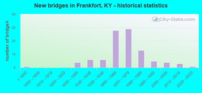
- New bridges - historical statistics
- 1Before 1900
- 41930-1939
- 61940-1949
- 61950-1959
- 281960-1969
- 291970-1979
- 131980-1989
- 51990-1999
- 42000-2009
- 32010-2019
- 12020-2022
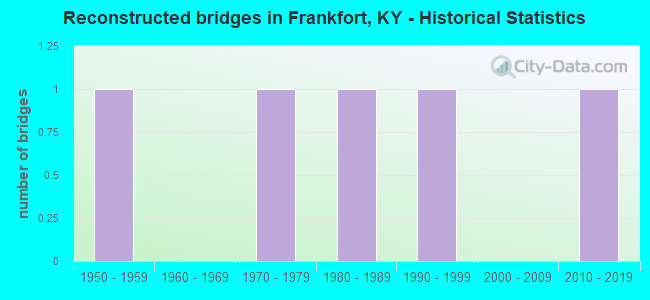
- Reconstructed bridges - Historical Statistics
- 11950-1959
- 01960-1969
- 11970-1979
- 11980-1989
- 11990-1999
- 02000-2009
- 12010-2019
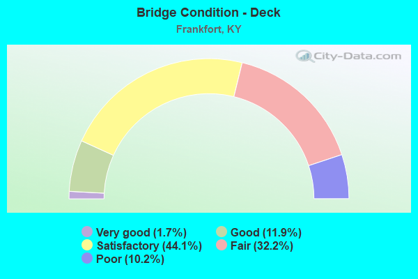
- Bridge Condition - Deck
- 1.7%Very good
- 11.9%Good
- 44.1%Satisfactory
- 32.2%Fair
- 10.2%Poor
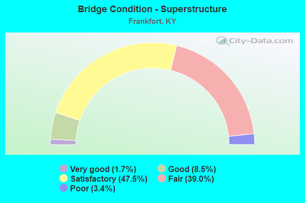
- Bridge Condition - Superstructure
- 1.7%Very good
- 8.5%Good
- 47.5%Satisfactory
- 39.0%Fair
- 3.4%Poor
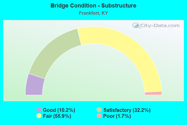
- Bridge Condition - Substructure
- 10.2%Good
- 32.2%Satisfactory
- 55.9%Fair
- 1.7%Poor
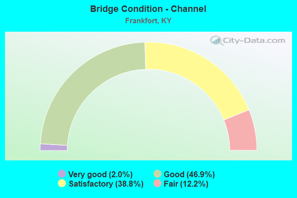
- Bridge Condition - Channel
- 2.0%Very good
- 46.9%Good
- 38.8%Satisfactory
- 12.2%Fair
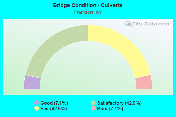
- Bridge Condition - Culverts
- 7.1%Good
- 42.9%Satisfactory
- 42.9%Fair
- 7.1%Poor
Find on map >> Show street view
Structure Number: 37B00090N, Location: 1.0 MI N OF US 60 (Lat: 38.195000, Lng: -84.894722), Route carried "under" structure: State highway 3505, Year Built: 1989, Structure Length: 0. m, Average Daily Traffic: 645 (year 2020), Truck Traffic: 18%, Features Intersected: KY 3505 (DEVILS HOLLOW), Facility Carried by Structure: US 127
Minimum Vertical Clearance: 4.78m (15.68ft), Kilometerpoint: 0.111, Lanes on structure: 4, Lanes under structure: 2, Material/Design: Prestressed concrete, Design/Construction: Box Beam or Girders - Single/Spread, Length of Maximum Span: 20.3m (66.6ft)
Find on map >> Show street view
Structure Number: 37B00091N, Location: 0.35 MI S OF KY 1211 (Lat: 38.208611, Lng: -84.890000), Route carried "under" structure: County highway 1300, Year Built: 1989, Structure Length: 0. m, Average Daily Traffic: 648 (year 2006), Features Intersected: RJC RR, BENSON VALLEY RD, Facility Carried by Structure: US 127
Minimum Vertical Clearance: 5.08m (16.67ft), Kilometerpoint: 0.912, Lanes on structure: 4, Lanes under structure: 2, Material/Design: Prestressed concrete continuous, Design/Construction: Stringer/Multi-beam, Length of Maximum Span: 27.1m (88.9ft)
Find on map >> Show street view
Structure Number: 37B00095N, Location: 125 FT N OF KY 420 (Lat: 38.203611, Lng: -84.878056), Route carried "under" structure: US 127, Year Built: 1989, Structure Length: 0. m, Average Daily Traffic: 14,530 (year 2019), Truck Traffic: 13%, Features Intersected: US 127, Facility Carried by Structure: PEDESTRIAN BRIDGE
Minimum Vertical Clearance: 5.05m (16.57ft), Kilometerpoint: 14.568, Lanes under structure: 5, Material/Design: Prestressed concrete, Design/Construction: Stringer/Multi-beam, Length of Maximum Span: 30.5m (100.1ft)
Find on map >> Show street view
Structure Number: 37B00096N, Location: 0.7 MI N OF KY 420 (Lat: 38.158333, Lng: -84.893611), Route carried "under" structure: Interstate 64, Year Built: 1992, Structure Length: 0. m, Average Daily Traffic: 40,724 (year 2020), Truck Traffic: 23%, Features Intersected: I-64, Facility Carried by Structure: US 127
Minimum Vertical Clearance: 5.44m (17.85ft), Kilometerpoint: 85.517, Lanes on structure: 6, Lanes under structure: 6, Material/Design: Prestressed concrete continuous, Design/Construction: Stringer/Multi-beam, Length of Maximum Span: 27.9m (91.5ft)
Find on map >> Show street view
Structure Number: 37R00600N, Location: 480 FT S OF US 127 (Lat: 38.200833, Lng: -84.880000), Route carried "under" structure: City street 1370, Year Built: 1930, Structure Length: 0. m, Average Daily Traffic: 3,247 (year 2018), Features Intersected: WILKINSON ST, Facility Carried by Structure: RJ CORMAN RAILROAD
Minimum Vertical Clearance: 3.30m (10.83ft), Kilometerpoint: 0.010, Lanes under structure: 2, Material/Design: Steel, Design/Construction: Girder and Floorbeam System, Length of Maximum Span: 13.7m (44.9ft)
Find on map >> Show street view
Structure Number: 37X00001N, Location: 1.1 MI N OF KY 676 (Lat: 38.185278, Lng: -84.873611), Route carried "under" structure: State highway 420, Year Built: 1977, Structure Length: 0. m, Average Daily Traffic: 4,224 (year 2018), Truck Traffic: 5%, Features Intersected: KY 420, Facility Carried by Structure: CAP PARKING GARAGE
Minimum Vertical Clearance: 6.73m (22.08ft), Kilometerpoint: 5.206, Lanes under structure: 2, Material/Design: Concrete, Design/Construction: Channel Beam, Length of Maximum Span: 8.4m (27.6ft)
Find on map >> Show street view
Structure Number: 37X00002N, Location: 0.25 MI E OF KY 1659 (Lat: 38.200278, Lng: -84.855278), Route carried "under" structure: US 60, Year Built: 2018, Structure Length: 0. m, Average Daily Traffic: 10,297 (year 2020), Truck Traffic: 7%, Features Intersected: US 60, Facility Carried by Structure: PEDESTRIAN BRIDGE
Minimum Vertical Clearance: 6.76m (22.18ft), Kilometerpoint: 15.456, Lanes under structure: 4, Material/Design: Prestressed concrete, Design/Construction: Box Beam or Girders - Single/Spread, Length of Maximum Span: 33.2m (108.9ft)
Find on map >> Show street view
Structure Number: 120B00020N, Location: 500FT E. OF FRANKLIN C.L. (Lat: 38.172778, Lng: -84.781389), Route carried "under" structure: Interstate 64, Year Built: 1972, Structure Length: 0. m, Average Daily Traffic: 24,152 (year 2020), Truck Traffic: 31%, Features Intersected: I 64, Facility Carried by Structure: DUCKERS RD
Minimum Vertical Clearance: 5.39m (17.68ft), Kilometerpoint: 95.832, Lanes on structure: 2, Lanes under structure: 4, Material/Design: Concrete continuous, Design/Construction: Tee Beam, Length of Maximum Span: 27.1m (88.9ft)