Bridge Statistics for Mesa, Arizona (AZ)
Condition, Traffic, Stress, Structural Evaluation, Project Costs
- National Bridge Inventory (NBI) Statistics
- 358Number of bridges
- 5,266ft / 1,605mTotal length
- $156,000Total costs
- 16,469,060Total average daily traffic
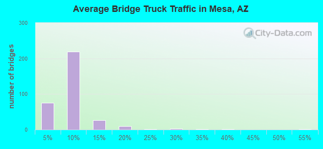
- 1,063,193Total average daily truck traffic
- National Bridge Inventory (NBI) Registered Bridges for Mesa
- No street view available for this location
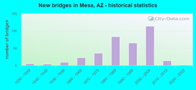
- New bridges - historical statistics
- 11920-1929
- 51930-1939
- 41940-1949
- 101950-1959
- 231960-1969
- 361970-1979
- 841980-1989
- 651990-1999
- 1142000-2009
- 142010-2019
- 22020-2022
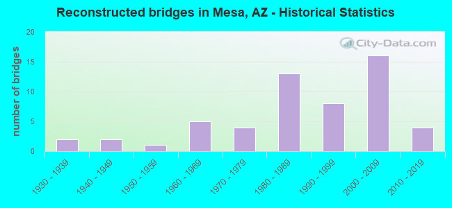
- Reconstructed bridges - Historical Statistics
- 21930-1939
- 21940-1949
- 11950-1959
- 51960-1969
- 41970-1979
- 131980-1989
- 81990-1999
- 162000-2009
- 42010-2019
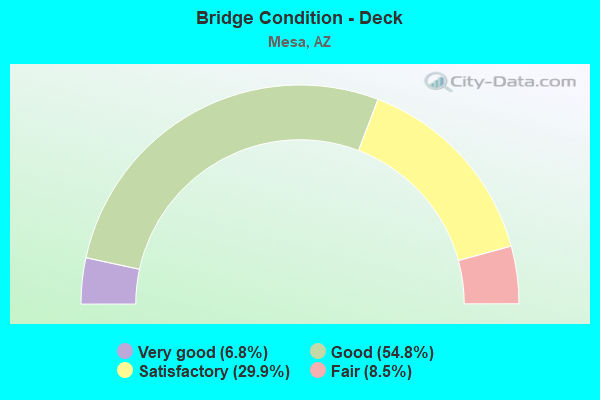
- Bridge Condition - Deck
- 6.8%Very good
- 54.8%Good
- 29.9%Satisfactory
- 8.5%Fair
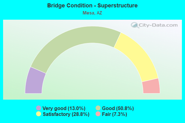
- Bridge Condition - Superstructure
- 13.0%Very good
- 50.8%Good
- 28.8%Satisfactory
- 7.3%Fair
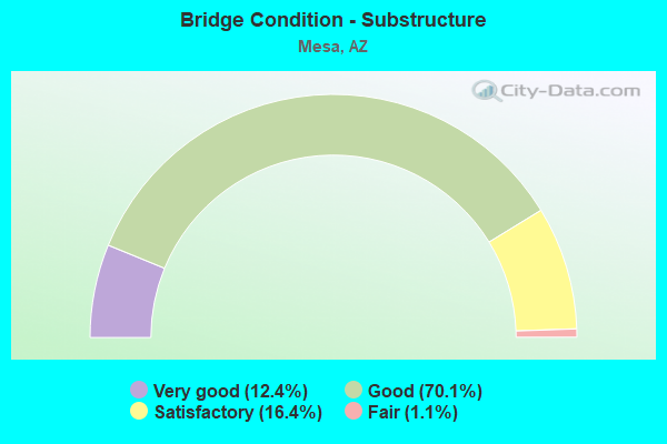
- Bridge Condition - Substructure
- 12.4%Very good
- 70.1%Good
- 16.4%Satisfactory
- 1.1%Fair
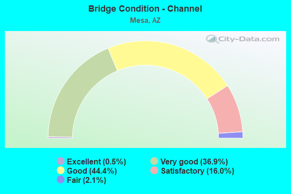
- Bridge Condition - Channel
- 0.5%Excellent
- 36.9%Very good
- 44.4%Good
- 16.0%Satisfactory
- 2.1%Fair
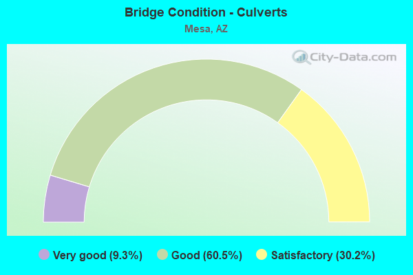
- Bridge Condition - Culverts
- 9.3%Very good
- 60.5%Good
- 30.2%Satisfactory
Find on map >> Show street view
Structure Number: 2704, Location: Approx. 13 mi. E of SR101 (Lat: 33.474889, Lng: -111.688000), Route carried "on" structure: State highway 202, Year Built: 2005, Status: Open, Structure Length: 5.49m (18.01ft), Average Daily Traffic: 72,498 (year 2018), Truck Traffic: 7%, Average Future Daily Traffic: 72,508 (year 2038), Design Load: HS 20, Features Intersected: Power Road
Minimum Vertical Clearance: 30+ m (98+ ft), Kilometerpoint: 37.015, Lanes on structure: 8, Lanes under structure: 4, Owner: State Highway Agency, Approaching Roadway Width: 44.6m (146.3ft), Skew: 36 degrees, Material/Design: Prestressed concrete, Design/Construction: Box Beam or Girders - Single/Spread, Number Of Spans In Main Unit: 1, Length of Maximum Span: 51.8m (169.9ft), Curb-To-Curb Width: 44.6m (146.3ft), Out-to-Out Width: 45.9m (150.6ft)
Condition: Deck: Good, Superstructure: Satisfactory, Substructure: Good, Operating Rating: 82.6 metric tons, Method Used To Determine Operating Rating: Load Factor (LF), Inventory Rating: 49.9 metric tons, Method Used To Determine Inventory Rating: Load Factor (LF), Structural Evaluation: Equal to present minimum criteria, Deck Geometry: Superior to present desirable criteria, Underclear: Equal to present minimum criteria, Approach Roadway Alignment: Equal to present desirable criteria, Designated Inspection Frequency: Every 24 months, Inspection Date: January 2022, Deck Structure Type: Concrete Cast-file-Place, Wearing Surface/Protective System: Wearing Surface: Bituminous
Find on map >> Show street view
Structure Number: 271, Location: 2.5mi E Power/Elliot Rd (Lat: 33.350111, Lng: -111.643944), Route carried "on" structure: State highway 202, Year Built: 2004, Status: Open, Structure Length: 6.58m (21.59ft), Average Daily Traffic: 88,846 (year 2018), Truck Traffic: 7%, Average Future Daily Traffic: 88,856 (year 2040), Design Load: HS 20, Features Intersected: Elliot Road
Minimum Vertical Clearance: 30+ m (98+ ft), Kilometerpoint: 53.221, Lanes on structure: 8, Lanes under structure: 9, Owner: State Highway Agency, Approaching Roadway Width: 53.6m (175.9ft), Skew: 30 degrees, Material/Design: Prestressed concrete continuous, Design/Construction: Stringer/Multi-beam, Number Of Spans In Main Unit: 2, Length of Maximum Span: 32.0m (105.0ft), Curb-To-Curb Width: 53.5m (175.5ft), Out-to-Out Width: 55.4m (181.8ft)
Condition: Deck: Good, Superstructure: Good, Substructure: Good, Operating Rating: 78.9 metric tons, Method Used To Determine Operating Rating: Load Factor (LF), Inventory Rating: 33.6 metric tons, Method Used To Determine Inventory Rating: Load Factor (LF), Structural Evaluation: Better than present minimum criteria, Deck Geometry: Superior to present desirable criteria, Approach Roadway Alignment: Better than present minimum criteria, Designated Inspection Frequency: Every 24 months, Inspection Date: Febuary 2020, Deck Structure Type: Concrete Cast-file-Place, Wearing Surface/Protective System: Wearing Surface: Bituminous
Find on map >> Show street view
Structure Number: 2712, Location: 1.25mi E Sosman+Guadalupe (Lat: 33.364639, Lng: -111.644056), Route carried "on" structure: City street , Year Built: 2004, Status: Open, Structure Length: 7.99m (26.21ft), Average Daily Traffic: 24,200 (year 2016), Truck Traffic: 10%, Average Future Daily Traffic: 24,210 (year 2040), Design Load: HS 20, Features Intersected: SR 202(Santan Fwy), Facility Carried by Structure: Guadalupe Road
Minimum Vertical Clearance: 30+ m (98+ ft), Kilometerpoint: 0.000, Lanes on structure: 10, Lanes under structure: 9, Owner: State Highway Agency, Approaching Roadway Width: 37.2m (122.0ft), Skew: 20 degrees, Material/Design: Prestressed concrete continuous, Design/Construction: Box Beam or Girders - Multiple, Number Of Spans In Main Unit: 2, Length of Maximum Span: 39.0m (128.0ft), Curb or Sidewalk Widths: Left: 1.7m (5.6ft), Right: 1.7m (5.6ft), Curb-To-Curb Width: 37.8m (124.0ft), Out-to-Out Width: 41.9m (137.5ft)
Condition: Deck: Good, Superstructure: Good, Substructure: Good, Operating Rating: 83.5 metric tons, Method Used To Determine Operating Rating: Load Factor (LF), Inventory Rating: 49.9 metric tons, Method Used To Determine Inventory Rating: Load Factor (LF), Structural Evaluation: Better than present minimum criteria, Deck Geometry: Somewhat better than minimum adequacy, Underclear: Equal to present minimum criteria, Approach Roadway Alignment: Equal to present desirable criteria, Designated Inspection Frequency: Every 24 months, Inspection Date: Febuary 2020, Deck Structure Type: Concrete Cast-file-Place, Wearing Surface/Protective System: Wearing Surface: Monolithic Concrete
Find on map >> Show street view
Structure Number: 2732, Location: 202L over Baseline Rd (Lat: 33.378928, Lng: -111.648822), Route carried "on" structure: State highway 202, Year Built: 2004, Status: Open, Structure Length: 5.67m (18.60ft), Average Daily Traffic: 82,707 (year 2020), Truck Traffic: 7%, Average Future Daily Traffic: 82,717 (year 2040), Design Load: HS 20, Features Intersected: Baseline Road TI OP SB
Minimum Vertical Clearance: 30+ m (98+ ft), Kilometerpoint: 49.938, Lanes on structure: 7, Lanes under structure: 6, Owner: State Highway Agency, Approaching Roadway Width: 43.9m (144.0ft), Material/Design: Prestressed concrete continuous, Design/Construction: Box Beam or Girders - Single/Spread, Number Of Spans In Main Unit: 2, Length of Maximum Span: 30.5m (100.1ft), Curb-To-Curb Width: 43.9m (144.0ft), Out-to-Out Width: 45.2m (148.3ft)
Condition: Deck: Good, Superstructure: Good, Substructure: Good, Operating Rating: 74.4 metric tons, Method Used To Determine Operating Rating: Load Factor (LF), Inventory Rating: 40.8 metric tons, Method Used To Determine Inventory Rating: Load Factor (LF), Structural Evaluation: Better than present minimum criteria, Deck Geometry: Superior to present desirable criteria, Underclear: Equal to present minimum criteria, Approach Roadway Alignment: Equal to present desirable criteria, Designated Inspection Frequency: Every 24 months, Inspection Date: November 2021, Deck Structure Type: Concrete Cast-file-Place, Wearing Surface/Protective System: Wearing Surface: Bituminous
Find on map >> Show street view
Structure Number: 2743, Location: Junction L202/US60 (Lat: 33.386642, Lng: -111.647817), Route carried "on" structure: State highway 202, Year Built: 2006, Status: Open, Structure Length: 10.33m (33.89ft), Average Daily Traffic: 11,791 (year 2020), Truck Traffic: 7%, Average Future Daily Traffic: 11,801 (year 2040), Design Load: HS 20, Features Intersected: US 60
Minimum Vertical Clearance: 30+ m (98+ ft), Kilometerpoint: 49.085, Lanes on structure: 3, Lanes under structure: 9, Owner: State Highway Agency, Approaching Roadway Width: 21.9m (71.9ft), Material/Design: Prestressed concrete continuous, Design/Construction: Box Beam or Girders - Single/Spread, Number Of Spans In Main Unit: 2, Length of Maximum Span: 54.3m (178.1ft), Curb-To-Curb Width: 21.9m (71.9ft), Out-to-Out Width: 22.9m (75.1ft)
Condition: Deck: Good, Superstructure: Good, Substructure: Good, Operating Rating: 89.8 metric tons, Method Used To Determine Operating Rating: Load Factor (LF), Inventory Rating: 89.8 metric tons, Method Used To Determine Inventory Rating: Load Factor (LF), Structural Evaluation: Better than present minimum criteria, Deck Geometry: Superior to present desirable criteria, Underclear: High priority of corrective action, Approach Roadway Alignment: Equal to present desirable criteria, Designated Inspection Frequency: Every 24 months, Inspection Date: December 2021, Deck Structure Type: Concrete Cast-file-Place, Wearing Surface/Protective System: Wearing Surface: Bituminous
Find on map >> Show street view
Structure Number: 2744, Location: Junction L202/US60 (Lat: 33.386672, Lng: -111.648283), Route carried "on" structure: State highway 202, Year Built: 2006, Status: Open, Structure Length: 10.97m (35.99ft), Average Daily Traffic: 12,491 (year 2020), Truck Traffic: 7%, Average Future Daily Traffic: 12,501 (year 2040), Design Load: HS 20, Features Intersected: US 60
Minimum Vertical Clearance: 5.33m (17.49ft), Kilometerpoint: 49.117, Lanes on structure: 3, Lanes under structure: 9, Owner: State Highway Agency, Approaching Roadway Width: 21.9m (71.9ft), Material/Design: Prestressed concrete continuous, Design/Construction: Box Beam or Girders - Single/Spread, Number Of Spans In Main Unit: 2, Length of Maximum Span: 59.1m (193.9ft), Curb-To-Curb Width: 21.9m (71.9ft), Out-to-Out Width: 22.9m (75.1ft)
Condition: Deck: Good, Superstructure: Good, Substructure: Good, Operating Rating: 56.2 metric tons, Method Used To Determine Operating Rating: Load Factor (LF), Inventory Rating: 33.6 metric tons, Method Used To Determine Inventory Rating: Load Factor (LF), Structural Evaluation: Better than present minimum criteria, Deck Geometry: Superior to present desirable criteria, Underclear: Equal to present minimum criteria, Approach Roadway Alignment: Equal to present desirable criteria, Designated Inspection Frequency: Every 24 months, Inspection Date: December 2021, Deck Structure Type: Concrete Cast-file-Place, Wearing Surface/Protective System: Wearing Surface: Bituminous
Find on map >> Show street view
Structure Number: 2745, Location: 1.25mi Eof SosmanRd &US60 (Lat: 33.387164, Lng: -111.648539), Route carried "on" structure: Ramp State highway 60, Year Built: 2004, Status: Open, Structure Length: 69.46m (227.89ft), Average Daily Traffic: 10,909 (year 2020), Truck Traffic: 4%, Average Future Daily Traffic: 10,919 (year 2040), Design Load: HS 20, Features Intersected: US60 202L Ramp E-N
Minimum Vertical Clearance: 5.15m (16.90ft), Kilometerpoint: 306.709, Lanes on structure: 2, Lanes under structure: 14, Owner: State Highway Agency, Approaching Roadway Width: 12.2m (40.0ft), Material/Design: Prestressed concrete continuous, Design/Construction: Box Beam or Girders - Single/Spread, Number Of Spans In Main Unit: 15, Length of Maximum Span: 64.9m (212.9ft), Curb-To-Curb Width: 12.2m (40.0ft), Out-to-Out Width: 13.2m (43.3ft)
Condition: Deck: Very good, Superstructure: Good, Substructure: Good, Operating Rating: 89.8 metric tons, Method Used To Determine Operating Rating: Load Factor (LF), Inventory Rating: 54.4 metric tons, Method Used To Determine Inventory Rating: Load Factor (LF), Structural Evaluation: Better than present minimum criteria, Deck Geometry: Superior to present desirable criteria, Underclear: Somewhat better than minimum adequacy, Approach Roadway Alignment: Equal to present desirable criteria, Designated Inspection Frequency: Every 24 months, Inspection Date: December 2021, Deck Structure Type: Concrete Cast-file-Place, Wearing Surface/Protective System: Wearing Surface: Bituminous
Find on map >> Show street view
Structure Number: 2746, Location: 1.25mi Eof SosmanRd &US60 (Lat: 33.386125, Lng: -111.647511), Route carried "on" structure: Ramp US 60, Year Built: 2006, Status: Open, Structure Length: 52.30m (171.59ft), Average Daily Traffic: 6,002 (year 2020), Truck Traffic: 4%, Average Future Daily Traffic: 6,012 (year 2040), Design Load: HS 20, Features Intersected: US60,202L, Ramp E-S
Minimum Vertical Clearance: 5.25m (17.22ft), Kilometerpoint: 306.854, Lanes on structure: 2, Lanes under structure: 17, Owner: State Highway Agency, Approaching Roadway Width: 12.2m (40.0ft), Material/Design: Prestressed concrete continuous, Design/Construction: Box Beam or Girders - Single/Spread, Number Of Spans In Main Unit: 8, Length of Maximum Span: 74.1m (243.1ft), Curb-To-Curb Width: 12.2m (40.0ft), Out-to-Out Width: 13.2m (43.3ft)
Condition: Deck: Good, Superstructure: Good, Substructure: Good, Operating Rating: 75.3 metric tons, Method Used To Determine Operating Rating: Load Factor (LF), Inventory Rating: 41.7 metric tons, Method Used To Determine Inventory Rating: Load Factor (LF), Structural Evaluation: Better than present minimum criteria, Deck Geometry: Superior to present desirable criteria, Underclear: Equal to present minimum criteria, Approach Roadway Alignment: Equal to present desirable criteria, Designated Inspection Frequency: Every 24 months, Inspection Date: December 2021, Deck Structure Type: Concrete Cast-file-Place, Wearing Surface/Protective System: Wearing Surface: Bituminous
Find on map >> Show street view
Structure Number: 2747, Location: 1.25mi Eof SosmanRd &US60 (Lat: 33.383100, Lng: -111.647400), Route carried "on" structure: Ramp State highway 202, Year Built: 2004, Status: Open, Structure Length: 75.22m (246.78ft), Average Daily Traffic: 22,041 (year 2020), Truck Traffic: 10%, Average Future Daily Traffic: 22,051 (year 2040), Design Load: HS 20, Features Intersected: US60 & 202L Ramp W-S, Facility Carried by Structure: US 60
Minimum Vertical Clearance: 30+ m (98+ ft), Kilometerpoint: 49.938, Lanes on structure: 2, Lanes under structure: 9, Owner: State Highway Agency, Approaching Roadway Width: 12.2m (40.0ft), Material/Design: Prestressed concrete continuous, Design/Construction: Box Beam or Girders - Single/Spread, Number Of Spans In Main Unit: 12, Length of Maximum Span: 68.6m (225.1ft), Curb-To-Curb Width: 12.3m (40.4ft), Out-to-Out Width: 13.2m (43.3ft)
Condition: Deck: Good, Superstructure: Satisfactory, Substructure: Good, Operating Rating: 89.8 metric tons, Method Used To Determine Operating Rating: Load Factor (LF), Inventory Rating: 60.8 metric tons, Method Used To Determine Inventory Rating: Load Factor (LF), Structural Evaluation: Equal to present minimum criteria, Deck Geometry: Superior to present desirable criteria, Underclear: High priority of corrective action, Approach Roadway Alignment: Equal to present minimum criteria, Designated Inspection Frequency: Every 24 months, Inspection Date: December 2021, Deck Structure Type: Concrete Cast-file-Place, Wearing Surface/Protective System: Wearing Surface: Bituminous
Find on map >> Show street view
Structure Number: 2748, Location: 1.25mi Eof SosmanRd &US60 (Lat: 33.391100, Lng: -111.648600), Route carried "on" structure: State highway 202, Year Built: 2004, Status: Open, Structure Length: 77.63m (254.69ft), Average Daily Traffic: 9,302 (year 2018), Truck Traffic: 3%, Average Future Daily Traffic: 9,312 (year 2038), Design Load: HS 20, Features Intersected: Ramp S-W, 202, Ramp E-N
Minimum Vertical Clearance: 30+ m (98+ ft), Kilometerpoint: 49.165, Lanes on structure: 1, Lanes under structure: 10, Owner: State Highway Agency, Approaching Roadway Width: 8.5m (27.9ft), Material/Design: Prestressed concrete continuous, Design/Construction: Box Beam or Girders - Single/Spread, Number Of Spans In Main Unit: 16, Length of Maximum Span: 64.0m (210.0ft), Curb-To-Curb Width: 8.5m (27.9ft), Out-to-Out Width: 9.5m (31.2ft)
Condition: Deck: Good, Superstructure: Good, Substructure: Good, Operating Rating: 67.1 metric tons, Method Used To Determine Operating Rating: Load Factor (LF), Inventory Rating: 39.9 metric tons, Method Used To Determine Inventory Rating: Load Factor (LF), Structural Evaluation: Better than present minimum criteria, Deck Geometry: Meets minimum limits, Underclear: Equal to present minimum criteria, Approach Roadway Alignment: Equal to present desirable criteria, Designated Inspection Frequency: Every 24 months, Inspection Date: December 2021, Deck Structure Type: Concrete Cast-file-Place, Wearing Surface/Protective System: Wearing Surface: Bituminous
Find on map >> Show street view
Structure Number: 2753, Location: Jct Santan/Warner (Lat: 33.335861, Lng: -111.646528), Route carried "on" structure: State highway 202, Year Built: 2006, Status: Open, Structure Length: 6.58m (21.59ft), Average Daily Traffic: 39,486 (year 2018), Truck Traffic: 7%, Average Future Daily Traffic: 39,496 (year 2040), Design Load: HS 20, Features Intersected: Warner Road
Minimum Vertical Clearance: 30+ m (98+ ft), Kilometerpoint: 54.879, Lanes on structure: 3, Lanes under structure: 5, Owner: State Highway Agency, Approaching Roadway Width: 28.7m (94.2ft), Skew: 3 degrees, Material/Design: Prestressed concrete continuous, Design/Construction: Box Beam or Girders - Single/Spread, Number Of Spans In Main Unit: 2, Length of Maximum Span: 32.0m (105.0ft), Curb-To-Curb Width: 28.7m (94.2ft), Out-to-Out Width: 29.6m (97.1ft)
Condition: Deck: Good, Superstructure: Good, Substructure: Good, Operating Rating: 68.9 metric tons, Method Used To Determine Operating Rating: Load Factor (LF), Inventory Rating: 39.9 metric tons, Method Used To Determine Inventory Rating: Load Factor (LF), Structural Evaluation: Better than present minimum criteria, Deck Geometry: Superior to present desirable criteria, Underclear: Superior to present desirable criteria, Approach Roadway Alignment: Equal to present desirable criteria, Designated Inspection Frequency: Every 24 months, Inspection Date: Febuary 2020, Deck Structure Type: Concrete Cast-file-Place, Wearing Surface/Protective System: Wearing Surface: Bituminous
Find on map >> Show street view
Structure Number: 2754, Location: Jct Hawes/Santan (Lat: 33.331167, Lng: -111.652917), Route carried "on" structure: State highway 202, Year Built: 2006, Status: Open, Structure Length: 6.52m (21.39ft), Average Daily Traffic: 78,972 (year 2018), Truck Traffic: 7%, Average Future Daily Traffic: 78,982 (year 2040), Design Load: HS 20, Features Intersected: Hawes Road
Minimum Vertical Clearance: 30+ m (98+ ft), Kilometerpoint: 55.796, Lanes on structure: 6, Lanes under structure: 4, Owner: State Highway Agency, Approaching Roadway Width: 46.3m (151.9ft), Skew: 32 degrees, Material/Design: Prestressed concrete continuous, Design/Construction: Box Beam or Girders - Multiple, Number Of Spans In Main Unit: 2, Length of Maximum Span: 32.0m (105.0ft), Curb-To-Curb Width: 46.3m (151.9ft), Out-to-Out Width: 48.2m (158.1ft)
Condition: Deck: Very good, Superstructure: Good, Substructure: Very good, Operating Rating: 89.8 metric tons, Method Used To Determine Operating Rating: Load Factor (LF), Inventory Rating: 60.8 metric tons, Method Used To Determine Inventory Rating: Load Factor (LF), Structural Evaluation: Better than present minimum criteria, Deck Geometry: Superior to present desirable criteria, Underclear: Superior to present desirable criteria, Approach Roadway Alignment: Better than present minimum criteria, Designated Inspection Frequency: Every 24 months, Inspection Date: Febuary 2020, Deck Structure Type: Concrete Cast-file-Place, Wearing Surface/Protective System: Wearing Surface: Bituminous
Find on map >> Show street view
Structure Number: 2756, Location: Jct Sossaman/Santan (Lat: 33.328194, Lng: -111.670250), Route carried "on" structure: State highway 202, Year Built: 2005, Status: Open, Structure Length: 3.78m (12.40ft), Average Daily Traffic: 61,337 (year 2018), Truck Traffic: 7%, Average Future Daily Traffic: 61,347 (year 2040), Design Load: HS 20, Features Intersected: Sossaman Road
Minimum Vertical Clearance: 30+ m (98+ ft), Kilometerpoint: 57.640, Lanes on structure: 8, Owner: State Highway Agency, Approaching Roadway Width: 58.5m (191.9ft), Skew: 30 degrees, Material/Design: Prestressed concrete, Design/Construction: Box Beam or Girders - Multiple, Number Of Spans In Main Unit: 1, Length of Maximum Span: 36.3m (119.1ft), Curb-To-Curb Width: 58.5m (191.9ft), Out-to-Out Width: 60.4m (198.2ft)
Condition: Deck: Good, Superstructure: Very good, Substructure: Good, Operating Rating: 79.8 metric tons, Method Used To Determine Operating Rating: Load Factor (LF), Inventory Rating: 47.2 metric tons, Method Used To Determine Inventory Rating: Load Factor (LF), Structural Evaluation: Better than present minimum criteria, Deck Geometry: Superior to present desirable criteria, Approach Roadway Alignment: Equal to present desirable criteria, Designated Inspection Frequency: Every 24 months, Inspection Date: Febuary 2020, Deck Structure Type: Concrete Cast-file-Place, Wearing Surface/Protective System: Wearing Surface: Bituminous
Find on map >> Show street view
Structure Number: 2758, Location: 202L 2 mi E Higley+PowerR (Lat: 33.328472, Lng: -111.687083), Route carried "on" structure: State highway 202, Year Built: 2004, Status: Open, Structure Length: 6.52m (21.39ft), Average Daily Traffic: 56,464 (year 2018), Truck Traffic: 9%, Average Future Daily Traffic: 56,474 (year 2040), Design Load: HS 20, Features Intersected: Power Road
Minimum Vertical Clearance: 30+ m (98+ ft), Kilometerpoint: 58.982, Lanes on structure: 6, Lanes under structure: 8, Owner: State Highway Agency, Approaching Roadway Width: 42.7m (140.1ft), Skew: 30 degrees, Material/Design: Prestressed concrete continuous, Design/Construction: Box Beam or Girders - Multiple, Number Of Spans In Main Unit: 2, Length of Maximum Span: 32.0m (105.0ft), Curb-To-Curb Width: 42.7m (140.1ft), Out-to-Out Width: 44.5m (146.0ft)
Condition: Deck: Good, Superstructure: Good, Substructure: Good, Operating Rating: 66.2 metric tons, Method Used To Determine Operating Rating: Load Factor (LF), Inventory Rating: 39.9 metric tons, Method Used To Determine Inventory Rating: Load Factor (LF), Structural Evaluation: Better than present minimum criteria, Deck Geometry: Superior to present desirable criteria, Underclear: Better than present minimum criteria, Approach Roadway Alignment: Equal to present desirable criteria, Designated Inspection Frequency: Every 24 months, Inspection Date: Febuary 2020, Deck Structure Type: Concrete Cast-file-Place, Wearing Surface/Protective System: Wearing Surface: Bituminous
Find on map >> Show street view
Structure Number: 276, Location: Just E of Power Rd/Santan (Lat: 33.328250, Lng: -111.682556), Route carried "on" structure: State highway 202, Year Built: 2006, Status: Open, Structure Length: 12.07m (39.60ft), Average Daily Traffic: 32,500 (year 2018), Truck Traffic: 7%, Average Future Daily Traffic: 32,510 (year 2040), Design Load: HS 20, Features Intersected: EMF & Roosevelt Canal
Minimum Vertical Clearance: 30+ m (98+ ft), Kilometerpoint: 58.600, Lanes on structure: 3, Owner: State Highway Agency, Approaching Roadway Width: 21.3m (69.9ft), Material/Design: Prestressed concrete continuous, Design/Construction: Stringer/Multi-beam, Number Of Spans In Main Unit: 4, Length of Maximum Span: 29.9m (98.1ft), Curb-To-Curb Width: 21.3m (69.9ft), Out-to-Out Width: 22.3m (73.2ft)
Condition: Deck: Good, Superstructure: Good, Substructure: Good, Channel: Very good, Operating Rating: 89.8 metric tons, Method Used To Determine Operating Rating: Load Factor (LF), Inventory Rating: 37.2 metric tons, Method Used To Determine Inventory Rating: Load Factor (LF), Structural Evaluation: Better than present minimum criteria, Deck Geometry: Superior to present desirable criteria, Waterway Adequacy: Equal to present desirable criteria, Approach Roadway Alignment: Equal to present desirable criteria, Designated Inspection Frequency: Every 24 months, Inspection Date: Febuary 2020, Deck Structure Type: Concrete Cast-file-Place, Wearing Surface/Protective System: Wearing Surface: Bituminous
Find on map >> Show street view
Structure Number: 2762, Location: Just E of Power Rd/Santan (Lat: 33.328700, Lng: -111.682700), Route carried "on" structure: Ramp State highway 202, Year Built: 2006, Status: Open, Structure Length: 12.07m (39.60ft), Average Daily Traffic: 6,000 (year 2020), Truck Traffic: 7%, Average Future Daily Traffic: 6,010 (year 2040), Design Load: HS 20, Features Intersected: EMF & Roosevelt Canal
Minimum Vertical Clearance: 30+ m (98+ ft), Kilometerpoint: 58.580, Lanes on structure: 1, Owner: State Highway Agency, Approaching Roadway Width: 9.8m (32.2ft), Material/Design: Prestressed concrete continuous, Design/Construction: Stringer/Multi-beam, Number Of Spans In Main Unit: 4, Length of Maximum Span: 29.9m (98.1ft), Curb-To-Curb Width: 9.8m (32.2ft), Out-to-Out Width: 10.6m (34.8ft)
Condition: Deck: Good, Superstructure: Very good, Substructure: Good, Channel: Very good, Operating Rating: 89.8 metric tons, Method Used To Determine Operating Rating: Load Factor (LF), Inventory Rating: 38.1 metric tons, Method Used To Determine Inventory Rating: Load Factor (LF), Structural Evaluation: Better than present minimum criteria, Deck Geometry: Superior to present desirable criteria, Waterway Adequacy: Equal to present desirable criteria, Approach Roadway Alignment: Equal to present desirable criteria, Designated Inspection Frequency: Every 24 months, Inspection Date: Febuary 2020, Deck Structure Type: Concrete Cast-file-Place, Wearing Surface/Protective System: Wearing Surface: Bituminous
Find on map >> Show street view
Structure Number: 2763, Location: Just E of Power Rd/Santan (Lat: 33.328000, Lng: -111.682700), Route carried "on" structure: Ramp State highway 202, Year Built: 2006, Status: Open, Structure Length: 12.07m (39.60ft), Average Daily Traffic: 6,000 (year 2020), Truck Traffic: 7%, Average Future Daily Traffic: 6,010 (year 2040), Design Load: HS 20, Features Intersected: EMF & Roosevelt Canal
Minimum Vertical Clearance: 30+ m (98+ ft), Kilometerpoint: 58.580, Lanes on structure: 1, Owner: State Highway Agency, Approaching Roadway Width: 9.8m (32.2ft), Material/Design: Prestressed concrete continuous, Design/Construction: Stringer/Multi-beam, Number Of Spans In Main Unit: 4, Length of Maximum Span: 29.9m (98.1ft), Curb-To-Curb Width: 9.8m (32.2ft), Out-to-Out Width: 10.6m (34.8ft)
Condition: Deck: Good, Superstructure: Very good, Substructure: Satisfactory, Channel: Very good, Operating Rating: 89.8 metric tons, Method Used To Determine Operating Rating: Load Factor (LF), Inventory Rating: 38.1 metric tons, Method Used To Determine Inventory Rating: Load Factor (LF), Structural Evaluation: Equal to present minimum criteria, Deck Geometry: Superior to present desirable criteria, Waterway Adequacy: Equal to present desirable criteria, Approach Roadway Alignment: Equal to present desirable criteria, Designated Inspection Frequency: Every 24 months, Inspection Date: Febuary 2020, Deck Structure Type: Concrete Cast-file-Place, Wearing Surface/Protective System: Wearing Surface: Bituminous
Find on map >> Show street view
Structure Number: 2794, Location: 202L/US60 (Lat: 33.387197, Lng: -111.635378), Route carried "on" structure: Ramp City street , Year Built: 2006, Status: Open, Structure Length: 14.97m (49.11ft), Average Daily Traffic: 5,667 (year 2018), Truck Traffic: 3%, Average Future Daily Traffic: 5,677 (year 2038), Design Load: HS 20, Features Intersected: US 60, Facility Carried by Structure: Ellsworth Road
Minimum Vertical Clearance: 30+ m (98+ ft), Kilometerpoint: 0.000, Lanes on structure: 2, Lanes under structure: 2, Owner: State Highway Agency, Approaching Roadway Width: 9.8m (32.2ft), Material/Design: Prestressed concrete continuous, Design/Construction: Box Beam or Girders - Single/Spread, Number Of Spans In Main Unit: 3, Length of Maximum Span: 63.1m (207.0ft), Curb-To-Curb Width: 9.8m (32.2ft), Out-to-Out Width: 10.7m (35.1ft)
Condition: Deck: Very good, Superstructure: Good, Substructure: Good, Operating Rating: 84.4 metric tons, Method Used To Determine Operating Rating: Load Factor (LF), Inventory Rating: 50.8 metric tons, Method Used To Determine Inventory Rating: Load Factor (LF), Structural Evaluation: Better than present minimum criteria, Deck Geometry: Equal to present minimum criteria, Underclear: Somewhat better than minimum adequacy, Approach Roadway Alignment: Equal to present desirable criteria, Designated Inspection Frequency: Every 24 months, Inspection Date: December 2021, Deck Structure Type: Concrete Cast-file-Place, Wearing Surface/Protective System: Wearing Surface: Bituminous
Find on map >> Show street view
Structure Number: 2809, Location: Gilbert Rd & US 60 (Lat: 33.386000, Lng: -111.788100), Route carried "on" structure: , Year Built: 2004, Status: Open, Structure Length: 7.38m (24.21ft), Design Load: Pedestrian, Features Intersected: US 60, Facility Carried by Structure: Gilbrt Rd Ped Path
Minimum Vertical Clearance: 3.96m (12.99ft), Kilometerpoint: 0.000, Lanes under structure: 12, Owner: State Highway Agency, Material/Design: Prestressed concrete continuous, Design/Construction: Box Beam or Girders - Single/Spread, Number Of Spans In Main Unit: 2, Length of Maximum Span: 36.0m (118.1ft), Out-to-Out Width: 3.0m (9.8ft)
Condition: Deck: Good, Superstructure: Good, Substructure: Good, Structural Evaluation: Better than present minimum criteria, Underclear: Equal to present minimum criteria, Designated Inspection Frequency: Every 24 months, Inspection Date: October 2021, Deck Structure Type: Concrete Cast-file-Place, Wearing Surface/Protective System: Wearing Surface: Monolithic Concrete
Find on map >> Show street view
Structure Number: 281, Location: Gilbert Rd & US 60 Intsn (Lat: 33.386000, Lng: -111.788700), Route carried "on" structure: , Year Built: 2004, Status: Open, Structure Length: 7.38m (24.21ft), Design Load: Pedestrian, Features Intersected: US 60, Facility Carried by Structure: Pedestrian OP
Minimum Vertical Clearance: 3.96m (12.99ft), Kilometerpoint: 0.000, Lanes under structure: 12, Owner: State Highway Agency, Material/Design: Prestressed concrete continuous, Design/Construction: Box Beam or Girders - Single/Spread, Number Of Spans In Main Unit: 2, Length of Maximum Span: 36.3m (119.1ft), Out-to-Out Width: 3.0m (9.8ft)
Condition: Deck: Good, Superstructure: Good, Substructure: Good, Structural Evaluation: Better than present minimum criteria, Underclear: Somewhat better than minimum adequacy, Designated Inspection Frequency: Every 24 months, Inspection Date: October 2021, Deck Structure Type: Concrete Cast-file-Place, Wearing Surface/Protective System: Wearing Surface: Monolithic Concrete
Find on map >> Show street view
Structure Number: 2825, Location: Power Rd/L 202 (Lat: 33.471361, Lng: -111.682806), Route carried "on" structure: State highway 202, Year Built: 2008, Status: Open, Structure Length: 31.58m (103.61ft), Average Daily Traffic: 38,991 (year 2018), Truck Traffic: 9%, Average Future Daily Traffic: 39,001 (year 2040), Design Load: HS 20, Features Intersected: CAP Canal
Minimum Vertical Clearance: 7.62m (25.00ft), Kilometerpoint: 37.353, Lanes on structure: 4, Lanes under structure: 6, Owner: State Highway Agency, Approaching Roadway Width: 25.0m (82.0ft), Material/Design: Prestressed concrete continuous, Design/Construction: Stringer/Multi-beam, Number Of Spans In Main Unit: 9, Length of Maximum Span: 43.3m (142.1ft), Curb-To-Curb Width: 25.0m (82.0ft), Out-to-Out Width: 26.2m (86.0ft)
Condition: Deck: Good, Superstructure: Very good, Substructure: Good, Channel: Very good, Operating Rating: 80.7 metric tons, Method Used To Determine Operating Rating: Load Factor (LF), Inventory Rating: 32.7 metric tons, Method Used To Determine Inventory Rating: Load Factor (LF), Structural Evaluation: Better than present minimum criteria, Deck Geometry: Superior to present desirable criteria, Underclear: High priority of corrective action, Waterway Adequacy: Equal to present desirable criteria, Approach Roadway Alignment: Better than present minimum criteria, Designated Inspection Frequency: Every 24 months, Inspection Date: January 2022, Deck Structure Type: Concrete Cast-file-Place, Wearing Surface/Protective System: Wearing Surface: Bituminous
Find on map >> Show street view
Structure Number: 2829, Location: McKellips Road/L202-Mesa (Lat: 33.451444, Lng: -111.669833), Route carried "on" structure: City street , Year Built: 2008, Status: Open, Structure Length: 9.11m (29.89ft), Average Daily Traffic: 13,700 (year 2016), Truck Traffic: 5%, Average Future Daily Traffic: 13,710 (year 2040), Design Load: HS 20, Features Intersected: SR 202L, Facility Carried by Structure: McKellips Road
Minimum Vertical Clearance: 30+ m (98+ ft), Kilometerpoint: 0.000, Lanes on structure: 4, Lanes under structure: 8, Owner: State Highway Agency, Approaching Roadway Width: 19.5m (64.0ft), Skew: 24 degrees, Material/Design: Prestressed concrete continuous, Design/Construction: Box Beam or Girders - Single/Spread, Number Of Spans In Main Unit: 2, Length of Maximum Span: 44.2m (145.0ft), Curb or Sidewalk Widths: Left: 3.7m (12.1ft), Right: 3.7m (12.1ft), Curb-To-Curb Width: 19.5m (64.0ft), Out-to-Out Width: 27.4m (89.9ft)
Condition: Deck: Good, Superstructure: Good, Substructure: Very good, Operating Rating: 89.8 metric tons, Method Used To Determine Operating Rating: Load Factor (LF), Inventory Rating: 60.8 metric tons, Method Used To Determine Inventory Rating: Load Factor (LF), Structural Evaluation: Better than present minimum criteria, Deck Geometry: Better than present minimum criteria, Underclear: Equal to present minimum criteria, Approach Roadway Alignment: Equal to present desirable criteria, Designated Inspection Frequency: Every 24 months, Inspection Date: Febuary 2020, Deck Structure Type: Concrete Cast-file-Place, Wearing Surface/Protective System: Wearing Surface: Monolithic Concrete
Find on map >> Show street view
Structure Number: 283, Location: Brown Road/L202 - Mesa (Lat: 33.436889, Lng: -111.650611), Route carried "on" structure: City street , Year Built: 2008, Status: Open, Structure Length: 12.28m (40.29ft), Average Daily Traffic: 12,900 (year 2016), Truck Traffic: 5%, Average Future Daily Traffic: 12,910 (year 2040), Design Load: HS 20, Features Intersected: SR 202L, Facility Carried by Structure: Brown Road
Minimum Vertical Clearance: 30+ m (98+ ft), Kilometerpoint: 0.000, Lanes on structure: 4, Lanes under structure: 8, Owner: State Highway Agency, Approaching Roadway Width: 19.5m (64.0ft), Skew: 25 degrees, Material/Design: Prestressed concrete continuous, Design/Construction: Box Beam or Girders - Single/Spread, Number Of Spans In Main Unit: 2, Length of Maximum Span: 60.4m (198.2ft), Curb or Sidewalk Widths: Left: 3.7m (12.1ft), Right: 3.7m (12.1ft), Curb-To-Curb Width: 19.5m (64.0ft), Out-to-Out Width: 27.4m (89.9ft)
Condition: Deck: Good, Superstructure: Very good, Substructure: Good, Operating Rating: 89.8 metric tons, Method Used To Determine Operating Rating: Load Factor (LF), Inventory Rating: 36.3 metric tons, Method Used To Determine Inventory Rating: Load Factor (LF), Structural Evaluation: Better than present minimum criteria, Deck Geometry: Better than present minimum criteria, Underclear: Equal to present minimum criteria, Approach Roadway Alignment: Equal to present desirable criteria, Designated Inspection Frequency: Every 24 months, Inspection Date: Febuary 2020, Deck Structure Type: Concrete Cast-file-Place, Wearing Surface/Protective System: Wearing Surface: Monolithic Concrete
Find on map >> Show street view
Structure Number: 2842, Location: L202/Universty Drive-Mesa (Lat: 33.423750, Lng: -111.636111), Route carried "on" structure: City street , Year Built: 2008, Status: Open, Structure Length: 6.80m (22.31ft), Average Daily Traffic: 24,800 (year 2016), Truck Traffic: 5%, Average Future Daily Traffic: 24,810 (year 2040), Design Load: HS 20, Features Intersected: SR 202L, Facility Carried by Structure: University Drive
Minimum Vertical Clearance: 30+ m (98+ ft), Kilometerpoint: 0.000, Lanes on structure: 10, Lanes under structure: 10, Owner: State Highway Agency, Approaching Roadway Width: 38.4m (126.0ft), Skew: 20 degrees, Material/Design: Prestressed concrete continuous, Design/Construction: Box Beam or Girders - Multiple, Number Of Spans In Main Unit: 2, Length of Maximum Span: 34.1m (111.9ft), Curb or Sidewalk Widths: Left: 2.4m (7.9ft), Right: 2.4m (7.9ft), Curb-To-Curb Width: 38.4m (126.0ft), Out-to-Out Width: 43.9m (144.0ft)
Condition: Deck: Good, Superstructure: Very good, Substructure: Very good, Operating Rating: 59.9 metric tons, Method Used To Determine Operating Rating: Load Factor (LF), Inventory Rating: 32.7 metric tons, Method Used To Determine Inventory Rating: Load Factor (LF), Structural Evaluation: Equal to present desirable criteria, Deck Geometry: Somewhat better than minimum adequacy, Underclear: Equal to present minimum criteria, Approach Roadway Alignment: Equal to present desirable criteria, Designated Inspection Frequency: Every 24 months, Inspection Date: Febuary 2020, Deck Structure Type: Concrete Cast-file-Place, Wearing Surface/Protective System: Wearing Surface: Monolithic Concrete
Find on map >> Show street view
Structure Number: 2843, Location: L202/Apache Trail - Mesa (Lat: 33.415278, Lng: -111.636944), Route carried "on" structure: City street , Year Built: 2008, Status: Open, Structure Length: 8.02m (26.31ft), Average Daily Traffic: 20,000 (year 2016), Truck Traffic: 5%, Average Future Daily Traffic: 20,010 (year 2040), Design Load: HS 20, Features Intersected: SR 202L, Facility Carried by Structure: Apache Trail
Minimum Vertical Clearance: 30+ m (98+ ft), Kilometerpoint: 0.000, Lanes on structure: 9, Lanes under structure: 9, Owner: State Highway Agency, Approaching Roadway Width: 35.1m (115.2ft), Skew: 22 degrees, Material/Design: Prestressed concrete continuous, Design/Construction: Box Beam or Girders - Multiple, Number Of Spans In Main Unit: 2, Length of Maximum Span: 39.9m (130.9ft), Curb or Sidewalk Widths: Left: 1.7m (5.6ft), Right: 1.7m (5.6ft), Curb-To-Curb Width: 35.1m (115.2ft), Out-to-Out Width: 39.1m (128.3ft)
Condition: Deck: Good, Superstructure: Good, Substructure: Very good, Operating Rating: 70.8 metric tons, Method Used To Determine Operating Rating: Load Factor (LF), Inventory Rating: 32.7 metric tons, Method Used To Determine Inventory Rating: Load Factor (LF), Structural Evaluation: Better than present minimum criteria, Deck Geometry: Somewhat better than minimum adequacy, Underclear: Equal to present minimum criteria, Approach Roadway Alignment: Equal to present desirable criteria, Designated Inspection Frequency: Every 24 months, Inspection Date: Febuary 2020, Deck Structure Type: Concrete Cast-file-Place, Wearing Surface/Protective System: Wearing Surface: Monolithic Concrete
Find on map >> Show street view
Structure Number: 2844, Location: Jct Broadway Rd East/L202 (Lat: 33.407833, Lng: -111.640278), Route carried "on" structure: City street , Year Built: 2007, Status: Open, Structure Length: 7.13m (23.39ft), Average Daily Traffic: 15,000 (year 2016), Truck Traffic: 3%, Average Future Daily Traffic: 15,010 (year 2040), Design Load: HS 20, Features Intersected: SR 202L, Facility Carried by Structure: Broadway Road
Minimum Vertical Clearance: 6.10m (20.01ft), Kilometerpoint: 0.000, Lanes on structure: 10, Lanes under structure: 10, Owner: State Highway Agency, Approaching Roadway Width: 37.2m (122.0ft), Skew: 20 degrees, Material/Design: Prestressed concrete continuous, Design/Construction: Box Beam or Girders - Multiple, Number Of Spans In Main Unit: 2, Length of Maximum Span: 37.5m (123.0ft), Curb or Sidewalk Widths: Left: 2.4m (7.9ft), Right: 2.4m (7.9ft), Curb-To-Curb Width: 37.2m (122.0ft), Out-to-Out Width: 43.9m (144.0ft)
Condition: Deck: Very good, Superstructure: Very good, Substructure: Good, Operating Rating: 89.8 metric tons, Method Used To Determine Operating Rating: Load Factor (LF), Inventory Rating: 42.6 metric tons, Method Used To Determine Inventory Rating: Load Factor (LF), Structural Evaluation: Better than present minimum criteria, Deck Geometry: Somewhat better than minimum adequacy, Underclear: Better than present minimum criteria, Approach Roadway Alignment: Equal to present desirable criteria, Designated Inspection Frequency: Every 24 months, Inspection Date: Febuary 2020, Deck Structure Type: Concrete Cast-file-Place, Wearing Surface/Protective System: Wearing Surface: Monolithic Concrete
Find on map >> Show street view
Structure Number: 2887, Location: 0.28 mi W of Alma School (Lat: 33.435300, Lng: -111.880300), Route carried "on" structure: State highway 202, Year Built: 1998, Status: Open, Structure Length: 1.86m (6.10ft), Average Daily Traffic: 150,477 (year 2017), Truck Traffic: 7%, Average Future Daily Traffic: 175,000 (year 2037), Design Load: HS 20, Features Intersected: Equipment Pass
Minimum Vertical Clearance: 30+ m (98+ ft), Kilometerpoint: 18.862, Lanes on structure: 12, Lanes under structure: 12, Owner: State Highway Agency, Approaching Roadway Width: 50.6m (166.0ft), Skew: 34 degrees, Material/Design: Concrete, Design/Construction: Frame, Number Of Spans In Main Unit: 1, Length of Maximum Span: 16.5m (54.1ft), Curb-To-Curb Width: 50.6m (166.0ft), Out-to-Out Width: 58.8m (192.9ft)
Condition: Deck: Satisfactory, Superstructure: Satisfactory, Substructure: Satisfactory, Operating Rating: 89.8 metric tons, Method Used To Determine Operating Rating: Load Factor (LF), Inventory Rating: 82.6 metric tons, Method Used To Determine Inventory Rating: Load Factor (LF), Structural Evaluation: Equal to present minimum criteria, Deck Geometry: Better than present minimum criteria, Approach Roadway Alignment: Equal to present desirable criteria, Designated Inspection Frequency: Every 24 months, Inspection Date: August 2020, Deck Structure Type: Concrete Cast-file-Place, Wearing Surface/Protective System: Wearing Surface: Bituminous
Find on map >> Show street view
Structure Number: 2997, Location: 3.66 mi S of US60 (Lat: 33.336100, Lng: -111.646700), Route carried "on" structure: Ramp State highway 202, Year Built: 2014, Status: Open, Structure Length: 98.91m (324.51ft), Average Daily Traffic: 5,000 (year 2020), Truck Traffic: 5%, Average Future Daily Traffic: 5,010 (year 2040), Design Load: HL 93, Features Intersected: Santan Frwy, Facility Carried by Structure: Ramp W-S Flyover
Minimum Vertical Clearance: 30+ m (98+ ft), Kilometerpoint: 54.975, Lanes on structure: 2, Lanes under structure: 15, Owner: State Highway Agency, Approaching Roadway Width: 12.2m (40.0ft), Material/Design: Prestressed concrete continuous, Design/Construction: Box Beam or Girders - Single/Spread, Number Of Spans In Main Unit: 21, Length of Maximum Span: 56.1m (184.1ft), Curb-To-Curb Width: 12.2m (40.0ft), Out-to-Out Width: 13.2m (43.3ft)
Condition: Deck: Good, Superstructure: Good, Substructure: Very good, Channel: Very good, Operating Rating: 75.3 metric tons, Method Used To Determine Operating Rating: Load Factor (LF), Inventory Rating: 45.4 metric tons, Method Used To Determine Inventory Rating: Load Factor (LF), Structural Evaluation: Better than present minimum criteria, Deck Geometry: Superior to present desirable criteria, Underclear: High priority of corrective action, Waterway Adequacy: Equal to present desirable criteria, Approach Roadway Alignment: Equal to present desirable criteria, Designated Inspection Frequency: Every 24 months, Inspection Date: August 2020, Deck Structure Type: Concrete Cast-file-Place, Wearing Surface/Protective System: Wearing Surface: Monolithic Concrete
Find on map >> Show street view
Structure Number: 4111, Location: 1.5 mi W of Ellsworth Rd (Lat: 33.415100, Lng: -111.660200), Route carried "on" structure: Alternate US 60, Year Built: 1930, Year Reconstructed: 1942, Status: Open, Structure Length: 0.73m (2.40ft), Average Daily Traffic: 7,000 (year 2014), Truck Traffic: 3%, Average Future Daily Traffic: 7,010 (year 2040), Design Load: HS 20, Features Intersected: Wash, Facility Carried by Structure: Apache Trl-Old US
Minimum Vertical Clearance: 30+ m (98+ ft), Kilometerpoint: 304.939, Lanes on structure: 3, Owner: State Highway Agency, Approaching Roadway Width: 11.0m (36.1ft), Skew: 3 degrees, Material/Design: Concrete continuous, Design/Construction: Culvert, Number Of Spans In Main Unit: 2, Length of Maximum Span: 3.0m (9.8ft), Curb or Sidewalk Widths: Left: 0.3m (1.0ft), Right: 0.3m (1.0ft), Curb-To-Curb Width: 12.2m (40.0ft), Out-to-Out Width: 14.6m (47.9ft)
Condition: Channel: Satisfactory, Culverts: Satisfactory, Operating Rating: 52.6 metric tons, Method Used To Determine Operating Rating: Load Factor (LF), Inventory Rating: 32.7 metric tons, Method Used To Determine Inventory Rating: Load Factor (LF), Structural Evaluation: Equal to present minimum criteria, Deck Geometry: Meets minimum limits, Waterway Adequacy: Somewhat better than minimum adequacy, Approach Roadway Alignment: Equal to present desirable criteria, Length Of Structure Improvement: 1.46m (4.79ft), Designated Inspection Frequency: Every 48 months, Inspection Date: January 2020, Total Project Cost: $1,000 ( Estimate for 2020), Deck Structure Type: Concrete Cast-file-Place, Wearing Surface/Protective System: Wearing Surface: Bituminous
Find on map >> Show street view
Structure Number: 4112, Location: 1.5 mi W of Ellsworth Rd (Lat: 33.415400, Lng: -111.659100), Route carried "on" structure: Alternate US 60, Year Built: 1961, Status: Open, Structure Length: 0.88m (2.89ft), Average Daily Traffic: 7,000 (year 2014), Truck Traffic: 3%, Average Future Daily Traffic: 7,010 (year 2040), Design Load: HS 20, Features Intersected: Wash, Facility Carried by Structure: Apache Trl-Old US
Minimum Vertical Clearance: 30+ m (98+ ft), Kilometerpoint: 304.939, Lanes on structure: 3, Owner: State Highway Agency, Approaching Roadway Width: 12.2m (40.0ft), Skew: 4 degrees, Material/Design: Concrete continuous, Design/Construction: Culvert, Number Of Spans In Main Unit: 2, Length of Maximum Span: 3.0m (9.8ft), Curb or Sidewalk Widths: Left: 0.3m (1.0ft), Right: 0.3m (1.0ft), Curb-To-Curb Width: 15.7m (51.5ft), Out-to-Out Width: 16.3m (53.5ft)
Condition: Channel: Satisfactory, Culverts: Satisfactory, Operating Rating: 52.6 metric tons, Method Used To Determine Operating Rating: Load Factor (LF), Inventory Rating: 32.7 metric tons, Method Used To Determine Inventory Rating: Load Factor (LF), Structural Evaluation: Equal to present minimum criteria, Deck Geometry: Better than present minimum criteria, Waterway Adequacy: Somewhat better than minimum adequacy, Approach Roadway Alignment: Equal to present desirable criteria, Designated Inspection Frequency: Every 48 months, Inspection Date: January 2020, Deck Structure Type: Concrete Cast-file-Place, Wearing Surface/Protective System: Wearing Surface: Bituminous
Find on map >> Show street view
Structure Number: 4115, Location: 4.0 mi W Jct SR 88 (Lat: 33.415100, Lng: -111.611900), Route carried "on" structure: Alternate State highway 60, Year Built: 1930, Year Reconstructed: 1942, Status: Open, Structure Length: 0.70m (2.30ft), Average Daily Traffic: 94,421 (year 2020), Truck Traffic: 3%, Average Future Daily Traffic: 94,431 (year 2040), Design Load: H 15, Features Intersected: Wash, Facility Carried by Structure: Apache Trail
Minimum Vertical Clearance: 30+ m (98+ ft), Kilometerpoint: 308.860, Lanes on structure: 3, Owner: State Highway Agency, Approaching Roadway Width: 11.6m (38.1ft), Material/Design: Concrete continuous, Design/Construction: Culvert, Number Of Spans In Main Unit: 2, Length of Maximum Span: 3.0m (9.8ft), Curb-To-Curb Width: 12.2m (40.0ft), Out-to-Out Width: 12.6m (41.3ft)
Condition: Channel: Satisfactory, Culverts: Satisfactory, Operating Rating: 52.6 metric tons, Method Used To Determine Operating Rating: Load Factor (LF), Inventory Rating: 32.7 metric tons, Method Used To Determine Inventory Rating: Load Factor (LF), Structural Evaluation: Equal to present minimum criteria, Deck Geometry: Meets minimum limits, Waterway Adequacy: Equal to present minimum criteria, Approach Roadway Alignment: Equal to present desirable criteria, Designated Inspection Frequency: Every 48 months, Inspection Date: January 2022, Deck Structure Type: Concrete Cast-file-Place, Wearing Surface/Protective System: Wearing Surface: Bituminous
Find on map >> Show street view
Structure Number: 4116, Location: 4.0 mi W Jct SR 88 (Lat: 33.415400, Lng: -111.611600), Route carried "on" structure: Alternate State highway 60, Year Built: 1961, Status: Open, Structure Length: 0.98m (3.22ft), Average Daily Traffic: 94,421 (year 2020), Truck Traffic: 3%, Average Future Daily Traffic: 94,431 (year 2040), Design Load: HS 20, Features Intersected: Wash, Facility Carried by Structure: Apache Trail
Minimum Vertical Clearance: 30+ m (98+ ft), Kilometerpoint: 308.860, Lanes on structure: 3, Owner: State Highway Agency, Approaching Roadway Width: 11.6m (38.1ft), Skew: 4 degrees, Material/Design: Concrete continuous, Design/Construction: Culvert, Number Of Spans In Main Unit: 2, Length of Maximum Span: 3.0m (9.8ft), Curb-To-Curb Width: 14.6m (47.9ft), Out-to-Out Width: 15.5m (50.9ft)
Condition: Channel: Satisfactory, Culverts: Satisfactory, Operating Rating: 52.6 metric tons, Method Used To Determine Operating Rating: Load Factor (LF), Inventory Rating: 32.7 metric tons, Method Used To Determine Inventory Rating: Load Factor (LF), Structural Evaluation: Equal to present minimum criteria, Deck Geometry: Somewhat better than minimum adequacy, Waterway Adequacy: Equal to present minimum criteria, Approach Roadway Alignment: Equal to present desirable criteria, Designated Inspection Frequency: Every 48 months, Inspection Date: January 2022, Deck Structure Type: Concrete Cast-file-Place, Wearing Surface/Protective System: Wearing Surface: Bituminous
Find on map >> Show street view
Structure Number: 4119, Location: 3.0 mi W Jct SR 88 (Lat: 33.415000, Lng: -111.601500), Route carried "on" structure: Alternate State highway 60, Year Built: 1930, Year Reconstructed: 1986, Status: Open, Structure Length: 0.73m (2.40ft), Average Daily Traffic: 94,421 (year 2020), Truck Traffic: 3%, Average Future Daily Traffic: 94,431 (year 2040), Design Load: HS 20, Features Intersected: Wash, Facility Carried by Structure: Apache Trail
Minimum Vertical Clearance: 12.19m (39.99ft), Kilometerpoint: 310.298, Lanes on structure: 3, Owner: State Highway Agency, Approaching Roadway Width: 11.6m (38.1ft), Skew: 3 degrees, Material/Design: Concrete continuous, Design/Construction: Culvert, Number Of Spans In Main Unit: 2, Length of Maximum Span: 3.0m (9.8ft), Curb-To-Curb Width: 16.8m (55.1ft), Out-to-Out Width: 29.9m (98.1ft)
Condition: Channel: Satisfactory, Culverts: Satisfactory, Operating Rating: 52.6 metric tons, Method Used To Determine Operating Rating: Load Factor (LF), Inventory Rating: 32.7 metric tons, Method Used To Determine Inventory Rating: Load Factor (LF), Structural Evaluation: Equal to present minimum criteria, Deck Geometry: Superior to present desirable criteria, Waterway Adequacy: Better than present minimum criteria, Approach Roadway Alignment: Better than present minimum criteria, Designated Inspection Frequency: Every 48 months, Inspection Date: January 2022, Deck Structure Type: Concrete Cast-file-Place, Wearing Surface/Protective System: Wearing Surface: Bituminous
Find on map >> Show street view
Structure Number: 412, Location: 3.0 mi W Jct SR 88 (Lat: 33.415400, Lng: -111.601300), Route carried "on" structure: Alternate State highway 60, Year Built: 1961, Status: Open, Structure Length: 0.73m (2.40ft), Average Daily Traffic: 94,421 (year 2020), Truck Traffic: 3%, Average Future Daily Traffic: 94,431 (year 2040), Design Load: HS 20, Features Intersected: Wash, Facility Carried by Structure: Apache Trail
Minimum Vertical Clearance: 30+ m (98+ ft), Kilometerpoint: 310.420, Lanes on structure: 3, Owner: State Highway Agency, Approaching Roadway Width: 11.6m (38.1ft), Skew: 3 degrees, Material/Design: Concrete continuous, Design/Construction: Culvert, Number Of Spans In Main Unit: 2, Length of Maximum Span: 3.0m (9.8ft), Curb-To-Curb Width: 15.0m (49.2ft), Out-to-Out Width: 15.6m (51.2ft)
Condition: Channel: Satisfactory, Culverts: Satisfactory, Operating Rating: 52.6 metric tons, Method Used To Determine Operating Rating: Load Factor (LF), Inventory Rating: 32.7 metric tons, Method Used To Determine Inventory Rating: Allowable Stress (AS), Structural Evaluation: Equal to present minimum criteria, Deck Geometry: Equal to present minimum criteria, Waterway Adequacy: Better than present minimum criteria, Approach Roadway Alignment: Better than present minimum criteria, Designated Inspection Frequency: Every 48 months, Inspection Date: January 2022, Deck Structure Type: Concrete Cast-file-Place, Wearing Surface/Protective System: Wearing Surface: Bituminous
Find on map >> Show street view
Structure Number: 6642, Location: 0.1 mi N US 60 (Lat: 33.385800, Lng: -111.874700), Route carried "on" structure: US 60, Year Built: 1977, Status: Open, Structure Length: 0.98m (3.22ft), Average Daily Traffic: 34,500 (year 2016), Truck Traffic: 3%, Average Future Daily Traffic: 34,510 (year 2036), Design Load: HS 20, Features Intersected: Drainage Channel, Facility Carried by Structure: Dobson Road
Minimum Vertical Clearance: 5.49m (18.01ft), Kilometerpoint: 285.690, Lanes on structure: 9, Owner: State Highway Agency, Approaching Roadway Width: 26.8m (87.9ft), Skew: 20 degrees, Material/Design: Concrete continuous, Design/Construction: Culvert, Number Of Spans In Main Unit: 3, Length of Maximum Span: 3.0m (9.8ft)
Condition: Channel: Very good, Culverts: Good, Operating Rating: 89.8 metric tons, Method Used To Determine Operating Rating: Load Factor (LF), Inventory Rating: 89.8 metric tons, Method Used To Determine Inventory Rating: Load Factor (LF), Structural Evaluation: Better than present minimum criteria, Waterway Adequacy: Equal to present desirable criteria, Approach Roadway Alignment: Equal to present desirable criteria, Length Of Structure Improvement: 1.74m (5.71ft), Designated Inspection Frequency: Every 48 months, Inspection Date: January 2022, Bridge Improvement Cost: $1,000, Roadway Improvement Cost: $1,000, Total Project Cost: $2,000 ( Estimate for 2014)
Find on map >> Show street view
Structure Number: 6687, Location: 0.1 mi N US 60 (Lat: 33.386500, Lng: -111.863800), Route carried "on" structure: US 60, Year Built: 1978, Status: Open, Structure Length: 0.98m (3.22ft), Average Daily Traffic: 4,800 (year 2016), Truck Traffic: 1%, Average Future Daily Traffic: 4,810 (year 2036), Design Load: HS 20, Features Intersected: Drainage Channel, Facility Carried by Structure: Longmore St
Minimum Vertical Clearance: 30+ m (98+ ft), Kilometerpoint: 286.580, Lanes on structure: 4, Owner: State Highway Agency, Approaching Roadway Width: 19.5m (64.0ft), Material/Design: Concrete continuous, Design/Construction: Culvert, Number Of Spans In Main Unit: 3, Length of Maximum Span: 3.0m (9.8ft)
Condition: Channel: Good, Culverts: Good, Operating Rating: 89.8 metric tons, Method Used To Determine Operating Rating: Load Factor (LF), Inventory Rating: 89.8 metric tons, Method Used To Determine Inventory Rating: Load Factor (LF), Structural Evaluation: Better than present minimum criteria, Waterway Adequacy: Better than present minimum criteria, Approach Roadway Alignment: Equal to present desirable criteria, Designated Inspection Frequency: Every 48 months, Inspection Date: January 2022
Find on map >> Show street view
Structure Number: 6688, Location: 0.1 mi N US 60 (Lat: 33.386800, Lng: -111.857400), Route carried "on" structure: US 60, Year Built: 1978, Status: Open, Structure Length: 0.98m (3.22ft), Average Daily Traffic: 39,800 (year 2017), Truck Traffic: 3%, Average Future Daily Traffic: 39,810 (year 2037), Design Load: HS 20, Features Intersected: Drainage Channel, Facility Carried by Structure: Alma School Road
Minimum Vertical Clearance: 30+ m (98+ ft), Kilometerpoint: 287.220, Lanes on structure: 10, Owner: State Highway Agency, Approaching Roadway Width: 30.5m (100.1ft), Skew: 20 degrees, Material/Design: Concrete continuous, Design/Construction: Culvert, Number Of Spans In Main Unit: 3, Length of Maximum Span: 3.0m (9.8ft)
Condition: Channel: Good, Culverts: Good, Operating Rating: 89.8 metric tons, Method Used To Determine Operating Rating: Load Factor (LF), Inventory Rating: 89.8 metric tons, Method Used To Determine Inventory Rating: Load Factor (LF), Structural Evaluation: Better than present minimum criteria, Waterway Adequacy: Equal to present desirable criteria, Approach Roadway Alignment: Equal to present desirable criteria, Length Of Structure Improvement: 1.74m (5.71ft), Designated Inspection Frequency: Every 48 months, Inspection Date: January 2022, Bridge Improvement Cost: $1,000, Roadway Improvement Cost: $1,000, Total Project Cost: $2,000 ( Estimate for 2014)
Find on map >> Show street view
Structure Number: 6689, Location: 0.1 mi No of US 60 (Lat: 33.386500, Lng: -111.848700), Route carried "on" structure: US 60, Year Built: 1978, Status: Open, Structure Length: 0.98m (3.22ft), Average Daily Traffic: 11,400 (year 2017), Truck Traffic: 1%, Average Future Daily Traffic: 11,410 (year 2037), Design Load: HS 20, Features Intersected: Drainage Channel, Facility Carried by Structure: Extension Road
Minimum Vertical Clearance: 30+ m (98+ ft), Kilometerpoint: 288.030, Lanes on structure: 4, Owner: State Highway Agency, Approaching Roadway Width: 19.5m (64.0ft), Material/Design: Concrete continuous, Design/Construction: Culvert, Number Of Spans In Main Unit: 3, Length of Maximum Span: 3.0m (9.8ft)
Condition: Channel: Good, Culverts: Good, Operating Rating: 89.8 metric tons, Method Used To Determine Operating Rating: Load Factor (LF), Inventory Rating: 89.8 metric tons, Method Used To Determine Inventory Rating: Load Factor (LF), Structural Evaluation: Better than present minimum criteria, Waterway Adequacy: Equal to present desirable criteria, Approach Roadway Alignment: Equal to present desirable criteria, Designated Inspection Frequency: Every 48 months, Inspection Date: January 2022
Find on map >> Show street view
Structure Number: 669, Location: N side at Jct US 60 (Lat: 33.387000, Lng: -111.840078), Route carried "on" structure: State highway 87, Year Built: 1978, Status: Open, Structure Length: 0.98m (3.22ft), Average Daily Traffic: 29,815 (year 2017), Truck Traffic: 9%, Average Future Daily Traffic: 29,825 (year 2039), Design Load: HS 20, Features Intersected: North Drainage
Minimum Vertical Clearance: 30+ m (98+ ft), Kilometerpoint: 278.079, Lanes on structure: 9, Owner: State Highway Agency, Approaching Roadway Width: 26.8m (87.9ft), Skew: 20 degrees, Material/Design: Concrete continuous, Design/Construction: Culvert, Number Of Spans In Main Unit: 3, Length of Maximum Span: 3.0m (9.8ft), Curb or Sidewalk Widths: Left: 1.5m (4.9ft), Right: 1.5m (4.9ft)
Condition: Channel: Good, Culverts: Good, Operating Rating: 89.8 metric tons, Method Used To Determine Operating Rating: Load Factor (LF), Inventory Rating: 89.8 metric tons, Method Used To Determine Inventory Rating: Load Factor (LF), Structural Evaluation: Better than present minimum criteria, Waterway Adequacy: Equal to present desirable criteria, Approach Roadway Alignment: Equal to present desirable criteria, Length Of Structure Improvement: 1.74m (5.71ft), Designated Inspection Frequency: Every 48 months, Inspection Date: May 2019, Bridge Improvement Cost: $1,000, Roadway Improvement Cost: $1,000, Total Project Cost: $2,000 ( Estimate for 2019)
Find on map >> Show street view
Structure Number: 6721, Location: 8.40 mi E Jct I 10 (Lat: 33.387100, Lng: -111.822900), Route carried "on" structure: ServiceUS 60, Year Built: 1980, Status: Open, Structure Length: 1.34m (4.40ft), Average Daily Traffic: 35,400 (year 2017), Truck Traffic: 3%, Average Future Daily Traffic: 35,410 (year 2037), Design Load: HS 20, Features Intersected: Drainage Channel, Facility Carried by Structure: Mesa Drive
Minimum Vertical Clearance: 5.49m (18.01ft), Kilometerpoint: 290.440, Lanes on structure: 9, Owner: State Highway Agency, Approaching Roadway Width: 29.3m (96.1ft), Skew: 20 degrees, Material/Design: Concrete continuous, Design/Construction: Culvert, Number Of Spans In Main Unit: 4, Length of Maximum Span: 3.0m (9.8ft)
Condition: Channel: Good, Culverts: Good, Operating Rating: 89.8 metric tons, Method Used To Determine Operating Rating: Load Factor (LF), Inventory Rating: 81.6 metric tons, Method Used To Determine Inventory Rating: Load Factor (LF), Structural Evaluation: Better than present minimum criteria, Waterway Adequacy: Equal to present desirable criteria, Approach Roadway Alignment: Equal to present desirable criteria, Length Of Structure Improvement: 2.10m (6.89ft), Designated Inspection Frequency: Every 48 months, Inspection Date: January 2022, Bridge Improvement Cost: $1,000, Roadway Improvement Cost: $1,000, Total Project Cost: $2,000 ( Estimate for 2014)
Find on map >> Show street view
Structure Number: 6722, Location: 0.1 mi N of US 60 (Lat: 33.386700, Lng: -111.814200), Route carried "on" structure: ServiceUS 60, Year Built: 1980, Status: Open, Structure Length: 1.31m (4.30ft), Average Daily Traffic: 225,171 (year 2020), Truck Traffic: 3%, Average Future Daily Traffic: 225,181 (year 2030), Design Load: HS 20, Features Intersected: Drainage Channel, Facility Carried by Structure: Horne Street
Minimum Vertical Clearance: 30+ m (98+ ft), Kilometerpoint: 291.250, Lanes on structure: 2, Owner: State Highway Agency, Approaching Roadway Width: 19.5m (64.0ft), Material/Design: Concrete continuous, Design/Construction: Culvert, Number Of Spans In Main Unit: 4, Length of Maximum Span: 3.0m (9.8ft)
Condition: Channel: Good, Culverts: Good, Operating Rating: 89.8 metric tons, Method Used To Determine Operating Rating: Load Factor (LF), Inventory Rating: 89.8 metric tons, Method Used To Determine Inventory Rating: Load Factor (LF), Structural Evaluation: Better than present minimum criteria, Waterway Adequacy: Better than present minimum criteria, Approach Roadway Alignment: Equal to present desirable criteria, Designated Inspection Frequency: Every 48 months, Inspection Date: January 2022
Find on map >> Show street view
Structure Number: 6723, Location: 9.40 mi E Jct I 10 (Lat: 33.387200, Lng: -111.805500), Route carried "on" structure: ServiceUS 60, Year Built: 1980, Status: Open, Structure Length: 0.98m (3.22ft), Average Daily Traffic: 225,171 (year 2020), Truck Traffic: 3%, Average Future Daily Traffic: 225,181 (year 2040), Design Load: HS 20, Features Intersected: Drainage Channel, Facility Carried by Structure: Stapley Drive
Minimum Vertical Clearance: 5.49m (18.01ft), Kilometerpoint: 292.050, Lanes on structure: 9, Owner: State Highway Agency, Approaching Roadway Width: 38.4m (126.0ft), Skew: 20 degrees, Material/Design: Concrete continuous, Design/Construction: Culvert, Number Of Spans In Main Unit: 3, Length of Maximum Span: 3.0m (9.8ft), Curb or Sidewalk Widths: Left: 1.5m (4.9ft), Right: 1.5m (4.9ft)
Condition: Channel: Good, Culverts: Good, Operating Rating: 89.8 metric tons, Method Used To Determine Operating Rating: Load Factor (LF), Inventory Rating: 89.8 metric tons, Method Used To Determine Inventory Rating: Load Factor (LF), Structural Evaluation: Better than present minimum criteria, Waterway Adequacy: Equal to present desirable criteria, Approach Roadway Alignment: Equal to present desirable criteria, Designated Inspection Frequency: Every 48 months, Inspection Date: January 2022
Find on map >> Show street view
Structure Number: 6742, Location: 0.1 mi N US 60 (Lat: 33.386200, Lng: -111.796900), Route carried "on" structure: ServiceUS 60, Year Built: 1981, Status: Open, Structure Length: 0.98m (3.22ft), Average Daily Traffic: 106,470 (year 2020), Truck Traffic: 2%, Average Future Daily Traffic: 106,480 (year 2040), Design Load: HS 20, Features Intersected: Drainage Channel, Facility Carried by Structure: Harris Drive
Minimum Vertical Clearance: 30+ m (98+ ft), Kilometerpoint: 292.860, Lanes on structure: 2, Owner: State Highway Agency, Approaching Roadway Width: 19.5m (64.0ft), Material/Design: Concrete continuous, Design/Construction: Culvert, Number Of Spans In Main Unit: 3, Length of Maximum Span: 3.0m (9.8ft), Curb or Sidewalk Widths: Left: 1.5m (4.9ft), Right: 1.5m (4.9ft)
Condition: Channel: Fair, Culverts: Good, Operating Rating: 89.8 metric tons, Method Used To Determine Operating Rating: Load Factor (LF), Inventory Rating: 89.8 metric tons, Method Used To Determine Inventory Rating: Load Factor (LF), Structural Evaluation: Better than present minimum criteria, Waterway Adequacy: Better than present minimum criteria, Approach Roadway Alignment: Better than present minimum criteria, Designated Inspection Frequency: Every 48 months, Inspection Date: January 2022