Bridge Statistics for Mesa, Arizona (AZ)
Condition, Traffic, Stress, Structural Evaluation, Project Costs
- National Bridge Inventory (NBI) Statistics
- 358Number of bridges
- 5,266ft / 1,605mTotal length
- $156,000Total costs
- 16,469,060Total average daily traffic
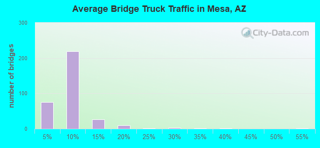
- 1,063,193Total average daily truck traffic
- National Bridge Inventory (NBI) Registered Bridges for Mesa
- No street view available for this location
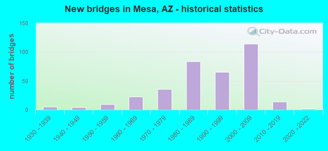
- New bridges - historical statistics
- 11920-1929
- 51930-1939
- 41940-1949
- 101950-1959
- 231960-1969
- 361970-1979
- 841980-1989
- 651990-1999
- 1142000-2009
- 142010-2019
- 22020-2022
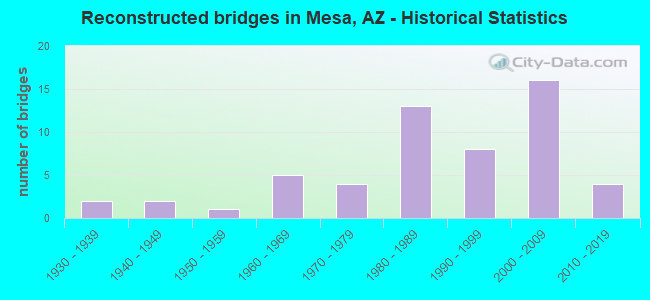
- Reconstructed bridges - Historical Statistics
- 21930-1939
- 21940-1949
- 11950-1959
- 51960-1969
- 41970-1979
- 131980-1989
- 81990-1999
- 162000-2009
- 42010-2019
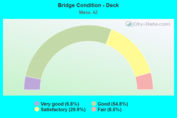
- Bridge Condition - Deck
- 6.8%Very good
- 54.8%Good
- 29.9%Satisfactory
- 8.5%Fair
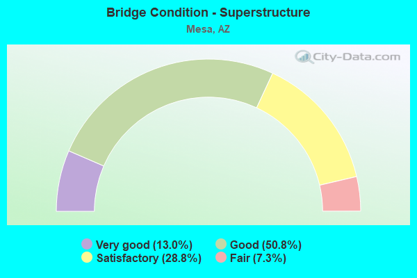
- Bridge Condition - Superstructure
- 13.0%Very good
- 50.8%Good
- 28.8%Satisfactory
- 7.3%Fair
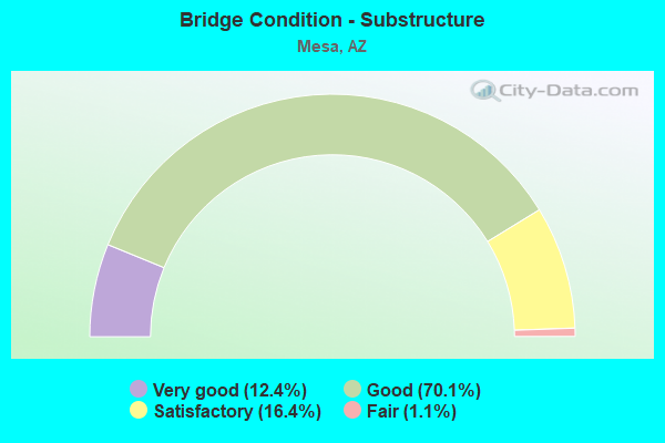
- Bridge Condition - Substructure
- 12.4%Very good
- 70.1%Good
- 16.4%Satisfactory
- 1.1%Fair
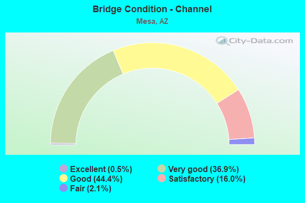
- Bridge Condition - Channel
- 0.5%Excellent
- 36.9%Very good
- 44.4%Good
- 16.0%Satisfactory
- 2.1%Fair
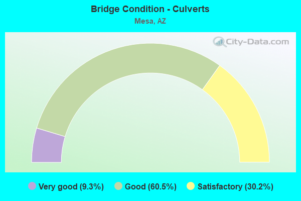
- Bridge Condition - Culverts
- 9.3%Very good
- 60.5%Good
- 30.2%Satisfactory
Find on map >> Show street view
Structure Number: 2743, Location: Junction L202/US60 (Lat: 33.386642, Lng: -111.647817), Route carried "under" structure: US 60, Year Built: 2006, Structure Length: 0. m, Average Daily Traffic: 115,100 (year 2020), Truck Traffic: 7%, Features Intersected: US 60, Facility Carried by Structure: L202 EB
Minimum Vertical Clearance: 5.23m (17.16ft), Kilometerpoint: 305.985, Lanes on structure: 3, Lanes under structure: 9, Material/Design: Prestressed concrete continuous, Design/Construction: Box Beam or Girders - Single/Spread, Length of Maximum Span: 54.3m (178.1ft)
Find on map >> Show street view
Structure Number: 2744, Location: Junction L202/US60 (Lat: 33.386672, Lng: -111.648283), Route carried "under" structure: US 60, Year Built: 2006, Structure Length: 0. m, Average Daily Traffic: 115,100 (year 2020), Truck Traffic: 7%, Features Intersected: US 60, Facility Carried by Structure: L202 WB
Minimum Vertical Clearance: 5.25m (17.22ft), Kilometerpoint: 305.985, Lanes on structure: 3, Lanes under structure: 9, Material/Design: Prestressed concrete continuous, Design/Construction: Box Beam or Girders - Single/Spread, Length of Maximum Span: 59.1m (193.9ft)
Find on map >> Show street view
Structure Number: 2746, Location: 1.25mi Eof SosmanRd &US60 (Lat: 33.386125, Lng: -111.647511), Route carried "under" structure: State highway 202, Year Built: 2006, Structure Length: 0. m, Average Daily Traffic: 76,097 (year 2020), Truck Traffic: 7%, Features Intersected: US60,202L, Ramp E-S, Facility Carried by Structure: US 60
Minimum Vertical Clearance: 5.08m (16.67ft), Kilometerpoint: 49.165, Lanes on structure: 2, Lanes under structure: 6, Material/Design: Prestressed concrete continuous, Design/Construction: Box Beam or Girders - Single/Spread, Length of Maximum Span: 74.1m (243.1ft)
Find on map >> Show street view
Structure Number: 2747, Location: 1.25mi Eof SosmanRd &US60 (Lat: 33.383100, Lng: -111.647400), Route carried "under" structure: US 60, Year Built: 2004, Structure Length: 0. m, Average Daily Traffic: 147,299 (year 2020), Truck Traffic: 7%, Features Intersected: US60 & 202L Ramp W-S
Minimum Vertical Clearance: 5.07m (16.63ft), Kilometerpoint: 305.614, Lanes on structure: 2, Lanes under structure: 9, Material/Design: Prestressed concrete continuous, Design/Construction: Box Beam or Girders - Single/Spread, Length of Maximum Span: 68.6m (225.1ft)
Find on map >> Show street view
Structure Number: 2748, Location: 1.25mi Eof SosmanRd &US60 (Lat: 33.391100, Lng: -111.648600), Route carried "under" structure: Ramp US 60, Year Built: 2004, Structure Length: 0. m, Average Daily Traffic: 153,744 (year 2019), Truck Traffic: 7%, Features Intersected: Ramp S-W, 202, Ramp E-N, Facility Carried by Structure: 202L
Minimum Vertical Clearance: 5.15m (16.90ft), Kilometerpoint: 306.548, Lanes on structure: 1, Lanes under structure: 8, Material/Design: Prestressed concrete continuous, Design/Construction: Box Beam or Girders - Single/Spread, Length of Maximum Span: 64.0m (210.0ft)
Find on map >> Show street view
Structure Number: 2753, Location: Jct Santan/Warner (Lat: 33.335861, Lng: -111.646528), Route carried "under" structure: City street , Year Built: 2006, Structure Length: 0. m, Average Daily Traffic: 500 (year 2016), Truck Traffic: 8%, Features Intersected: Warner Road, Facility Carried by Structure: SR 202L
Minimum Vertical Clearance: 5.23m (17.16ft), Kilometerpoint: 0.000, Lanes on structure: 3, Lanes under structure: 5, Material/Design: Prestressed concrete continuous, Design/Construction: Box Beam or Girders - Single/Spread, Length of Maximum Span: 32.0m (105.0ft)
Find on map >> Show street view
Structure Number: 2754, Location: Jct Hawes/Santan (Lat: 33.331167, Lng: -111.652917), Route carried "under" structure: City street , Year Built: 2006, Structure Length: 0. m, Average Daily Traffic: 1,300 (year 2016), Truck Traffic: 4%, Features Intersected: Hawes Road, Facility Carried by Structure: SR 202L
Minimum Vertical Clearance: 5.25m (17.22ft), Kilometerpoint: 0.000, Lanes on structure: 6, Lanes under structure: 3, Material/Design: Prestressed concrete continuous, Design/Construction: Box Beam or Girders - Multiple, Length of Maximum Span: 32.0m (105.0ft)
Find on map >> Show street view
Structure Number: 2756, Location: Jct Sossaman/Santan (Lat: 33.328194, Lng: -111.670250), Route carried "under" structure: City street , Year Built: 2005, Structure Length: 0. m, Features Intersected: Sossaman Road, Facility Carried by Structure: SR 202L
Minimum Vertical Clearance: 5.43m (17.81ft), Kilometerpoint: 0.000, Lanes on structure: 8, Material/Design: Prestressed concrete, Design/Construction: Box Beam or Girders - Multiple, Length of Maximum Span: 36.3m (119.1ft)
Find on map >> Show street view
Structure Number: 2758, Location: 202L 2 mi E Higley+PowerR (Lat: 33.328472, Lng: -111.687083), Route carried "under" structure: City street , Year Built: 2004, Structure Length: 0. m, Average Daily Traffic: 15,400 (year 2016), Truck Traffic: 5%, Features Intersected: Power Road, Facility Carried by Structure: SR 202L
Minimum Vertical Clearance: 5.96m (19.55ft), Kilometerpoint: 0.000, Lanes on structure: 6, Lanes under structure: 3, Material/Design: Prestressed concrete continuous, Design/Construction: Box Beam or Girders - Multiple, Length of Maximum Span: 32.0m (105.0ft)
Find on map >> Show street view
Structure Number: 2794, Location: 202L/US60 (Lat: 33.387197, Lng: -111.635378), Route carried "under" structure: Ramp US 60, Year Built: 2006, Structure Length: 0. m, Average Daily Traffic: 9,517 (year 2019), Truck Traffic: 7%, Features Intersected: US 60, Facility Carried by Structure: Ellsworth Road
Minimum Vertical Clearance: 5.05m (16.57ft), Kilometerpoint: 307.690, Lanes on structure: 2, Lanes under structure: 2, Material/Design: Prestressed concrete continuous, Design/Construction: Box Beam or Girders - Single/Spread, Length of Maximum Span: 63.1m (207.0ft)
Find on map >> Show street view
Structure Number: 2796, Location: Jct Red-Mountain/Southern (Lat: 33.393561, Lng: -111.645403), Route carried "under" structure: City street , Year Built: 2006, Structure Length: 0. m, Average Daily Traffic: 13,376 (year 2020), Truck Traffic: 5%, Features Intersected: Southern Ave, Facility Carried by Structure: SL 202
Minimum Vertical Clearance: 5.22m (17.13ft), Kilometerpoint: 0.000, Lanes on structure: 2, Lanes under structure: 6, Material/Design: Prestressed concrete, Design/Construction: Box Beam or Girders - Single/Spread, Length of Maximum Span: 43.6m (143.0ft)
Find on map >> Show street view
Structure Number: 2797, Location: Jct Red-Mountain/Southern (Lat: 33.393561, Lng: -111.646431), Route carried "under" structure: City street , Year Built: 2006, Structure Length: 0. m, Average Daily Traffic: 13,376 (year 2020), Truck Traffic: 5%, Features Intersected: Southern Ave, Facility Carried by Structure: SL 202
Minimum Vertical Clearance: 6.34m (20.80ft), Kilometerpoint: 0.000, Lanes on structure: 1, Lanes under structure: 6, Material/Design: Prestressed concrete, Design/Construction: Box Beam or Girders - Single/Spread, Length of Maximum Span: 51.5m (169.0ft)
Find on map >> Show street view
Structure Number: 2798, Location: Jct Red-Mountain/Southern (Lat: 33.393561, Lng: -111.646083), Route carried "under" structure: City street , Year Built: 2006, Structure Length: 0. m, Average Daily Traffic: 13,376 (year 2020), Truck Traffic: 5%, Features Intersected: Southern Ave, Facility Carried by Structure: SL 202
Minimum Vertical Clearance: 5.30m (17.39ft), Kilometerpoint: 0.000, Lanes on structure: 4, Lanes under structure: 6, Material/Design: Prestressed concrete, Design/Construction: Box Beam or Girders - Single/Spread, Length of Maximum Span: 46.0m (150.9ft)
Find on map >> Show street view
Structure Number: 2799, Location: Jct Red-Mountain/Southern (Lat: 33.393400, Lng: -111.645700), Route carried "under" structure: City street , Year Built: 2006, Structure Length: 0. m, Average Daily Traffic: 13,376 (year 2020), Truck Traffic: 5%, Features Intersected: Southern Ave, Facility Carried by Structure: SL 202
Minimum Vertical Clearance: 5.28m (17.32ft), Kilometerpoint: 0.000, Lanes on structure: 4, Lanes under structure: 6, Material/Design: Prestressed concrete, Design/Construction: Box Beam or Girders - Single/Spread, Length of Maximum Span: 45.7m (149.9ft)
Find on map >> Show street view
Structure Number: 2809, Location: Gilbert Rd & US 60 (Lat: 33.386000, Lng: -111.788100), Route carried "under" structure: US 60, Year Built: 2004, Structure Length: 0. m, Average Daily Traffic: 205,773 (year 2018), Truck Traffic: 7%, Features Intersected: US 60, Facility Carried by Structure: Gilbrt Rd Ped Path
Minimum Vertical Clearance: 5.98m (19.62ft), Kilometerpoint: 293.560, Lanes under structure: 12, Material/Design: Prestressed concrete continuous, Design/Construction: Box Beam or Girders - Single/Spread, Length of Maximum Span: 36.0m (118.1ft)
Find on map >> Show street view
Structure Number: 281, Location: Gilbert Rd & US 60 Intsn (Lat: 33.386000, Lng: -111.788700), Route carried "under" structure: US 60, Year Built: 2004, Structure Length: 0. m, Average Daily Traffic: 205,773 (year 2018), Truck Traffic: 7%, Features Intersected: US 60, Facility Carried by Structure: Pedestrian OP
Minimum Vertical Clearance: 5.97m (19.59ft), Kilometerpoint: 293.512, Lanes under structure: 12, Material/Design: Prestressed concrete continuous, Design/Construction: Box Beam or Girders - Single/Spread, Length of Maximum Span: 36.3m (119.1ft)
Find on map >> Show street view
Structure Number: 2825, Location: Power Rd/L 202 (Lat: 33.471361, Lng: -111.682806), Route carried "under" structure: City street , Year Built: 2008, Structure Length: 0. m, Average Daily Traffic: 19,000 (year 2016), Truck Traffic: 5%, Features Intersected: CAP Canal, Facility Carried by Structure: SR 202L
Minimum Vertical Clearance: 6.02m (19.75ft), Kilometerpoint: 0.000, Lanes on structure: 4, Lanes under structure: 3, Material/Design: Prestressed concrete continuous, Design/Construction: Stringer/Multi-beam, Length of Maximum Span: 43.3m (142.1ft)
Find on map >> Show street view
Structure Number: 2826, Location: Power/L 202 (Lat: 33.471889, Lng: -111.682833), Route carried "under" structure: City street , Year Built: 2008, Structure Length: 0. m, Average Daily Traffic: 19,000 (year 2016), Truck Traffic: 5%, Features Intersected: CAP Canal, Facility Carried by Structure: SR 202L
Minimum Vertical Clearance: 6.87m (22.54ft), Kilometerpoint: 0.000, Lanes on structure: 3, Lanes under structure: 3, Material/Design: Prestressed concrete continuous, Design/Construction: Stringer/Multi-beam, Length of Maximum Span: 42.7m (140.1ft)
Find on map >> Show street view
Structure Number: 2828, Location: McDowell/L202 - Mesa (Lat: 33.466333, Lng: -111.679583), Route carried "under" structure: State highway 202, Year Built: 2008, Structure Length: 0. m, Average Daily Traffic: 76,589 (year 2018), Truck Traffic: 9%, Features Intersected: SR 202L, Facility Carried by Structure: McDowell Road
Minimum Vertical Clearance: 6.27m (20.57ft), Kilometerpoint: 38.222, Lanes on structure: 8, Lanes under structure: 8, Material/Design: Prestressed concrete continuous, Design/Construction: Box Beam or Girders - Single/Spread, Length of Maximum Span: 36.6m (120.1ft)
Find on map >> Show street view
Structure Number: 2829, Location: McKellips Road/L202-Mesa (Lat: 33.451444, Lng: -111.669833), Route carried "under" structure: State highway 202, Year Built: 2008, Structure Length: 0. m, Average Daily Traffic: 76,589 (year 2018), Truck Traffic: 9%, Features Intersected: SR 202L, Facility Carried by Structure: McKellips Road
Minimum Vertical Clearance: 5.73m (18.80ft), Kilometerpoint: 40.137, Lanes on structure: 4, Lanes under structure: 4, Material/Design: Prestressed concrete continuous, Design/Construction: Box Beam or Girders - Single/Spread, Length of Maximum Span: 44.2m (145.0ft)
Find on map >> Show street view
Structure Number: 283, Location: Brown Road/L202 - Mesa (Lat: 33.436889, Lng: -111.650611), Route carried "under" structure: State highway 202, Year Built: 2008, Structure Length: 0. m, Average Daily Traffic: 72,332 (year 2018), Truck Traffic: 6%, Features Intersected: SR 202L, Facility Carried by Structure: Brown Road
Minimum Vertical Clearance: 6.58m (21.59ft), Kilometerpoint: 42.535, Lanes on structure: 4, Lanes under structure: 4, Material/Design: Prestressed concrete continuous, Design/Construction: Box Beam or Girders - Single/Spread, Length of Maximum Span: 60.4m (198.2ft)
Find on map >> Show street view
Structure Number: 2835, Location: 202L 0.7 mi SE of Brown (Lat: 33.432161, Lng: -111.640289), Route carried "under" structure: Other road , Year Built: 2008, Structure Length: 0. m, Average Daily Traffic: 10 (year 2016), Truck Traffic: 50%, Features Intersected: Spook Hill, Facility Carried by Structure: SR 202L
Minimum Vertical Clearance: 4.83m (15.85ft), Kilometerpoint: 0.000, Lanes on structure: 8, Lanes under structure: 8, Material/Design: Concrete, Design/Construction: Frame, Length of Maximum Span: 9.4m (30.8ft)
Find on map >> Show street view
Structure Number: 2842, Location: L202/Universty Drive-Mesa (Lat: 33.423750, Lng: -111.636111), Route carried "under" structure: State highway 202, Year Built: 2008, Structure Length: 0. m, Average Daily Traffic: 71,958 (year 2018), Truck Traffic: 6%, Features Intersected: SR 202L, Facility Carried by Structure: University Drive
Minimum Vertical Clearance: 6.55m (21.49ft), Kilometerpoint: 45.062, Lanes on structure: 10, Lanes under structure: 10, Material/Design: Prestressed concrete continuous, Design/Construction: Box Beam or Girders - Multiple, Length of Maximum Span: 34.1m (111.9ft)
Find on map >> Show street view
Structure Number: 2843, Location: L202/Apache Trail - Mesa (Lat: 33.415278, Lng: -111.636944), Route carried "under" structure: State highway 202, Year Built: 2008, Structure Length: 0. m, Average Daily Traffic: 71,958 (year 2018), Truck Traffic: 6%, Features Intersected: SR 202L, Facility Carried by Structure: Apache Trail
Minimum Vertical Clearance: 6.88m (22.57ft), Kilometerpoint: 45.866, Lanes on structure: 9, Lanes under structure: 9, Material/Design: Prestressed concrete continuous, Design/Construction: Box Beam or Girders - Multiple, Length of Maximum Span: 39.9m (130.9ft)
Find on map >> Show street view
Structure Number: 2844, Location: Jct Broadway Rd East/L202 (Lat: 33.407833, Lng: -111.640278), Route carried "under" structure: State highway 202, Year Built: 2007, Structure Length: 0. m, Average Daily Traffic: 72,540 (year 2018), Truck Traffic: 6%, Features Intersected: SR 202L, Facility Carried by Structure: Broadway Road
Minimum Vertical Clearance: 5.89m (19.32ft), Kilometerpoint: 46.671, Lanes on structure: 10, Lanes under structure: 10, Material/Design: Prestressed concrete continuous, Design/Construction: Box Beam or Girders - Multiple, Length of Maximum Span: 37.5m (123.0ft)
Find on map >> Show street view
Structure Number: 2887, Location: 0.28 mi W of Alma School (Lat: 33.435300, Lng: -111.880300), Route carried "under" structure: City street , Year Built: 1998, Structure Length: 0. m, Average Daily Traffic: 700 (year 2017), Truck Traffic: 99%, Features Intersected: Equipment Pass, Facility Carried by Structure: SL 202
Minimum Vertical Clearance: 5.07m (16.63ft), Kilometerpoint: 0.000, Lanes on structure: 12, Lanes under structure: 12, Material/Design: Concrete, Design/Construction: Frame, Length of Maximum Span: 16.5m (54.1ft)
Find on map >> Show street view
Structure Number: 2997, Location: 3.66 mi S of US60 (Lat: 33.336100, Lng: -111.646700), Route carried "under" structure: State highway 202, Year Built: 2014, Structure Length: 0. m, Average Daily Traffic: 79,629 (year 2019), Truck Traffic: 7%, Features Intersected: Santan Frwy, Facility Carried by Structure: Ramp W-S Flyover
Minimum Vertical Clearance: 15.24m (50.00ft), Kilometerpoint: 54.959, Lanes on structure: 2, Lanes under structure: 7, Material/Design: Prestressed concrete continuous, Design/Construction: Box Beam or Girders - Single/Spread, Length of Maximum Span: 56.1m (184.1ft)
Find on map >> Show street view
Structure Number: 2998, Location: 2450' N of Ray Rd (Lat: 33.329900, Lng: -111.653400), Route carried "under" structure: City street , Year Built: 2013, Structure Length: 0. m, Average Daily Traffic: 3,804 (year 2019), Truck Traffic: 5%, Features Intersected: Hawes Road, Facility Carried by Structure: Ramp E-S
Minimum Vertical Clearance: 6.07m (19.91ft), Kilometerpoint: 0.000, Lanes on structure: 1, Lanes under structure: 4, Material/Design: Prestressed concrete continuous, Design/Construction: Box Beam or Girders - Single/Spread, Length of Maximum Span: 39.0m (128.0ft)
Find on map >> Show street view
Structure Number: 2999, Location: TI with SR24 (Lat: 33.330500, Lng: -111.648900), Route carried "under" structure: State highway 202, Year Built: 2012, Structure Length: 0. m, Average Daily Traffic: 79,629 (year 2019), Truck Traffic: 7%, Features Intersected: Hawes Road, Facility Carried by Structure: Ramp N-W
Minimum Vertical Clearance: 11.32m (37.14ft), Kilometerpoint: 56.021, Lanes on structure: 1, Lanes under structure: 7, Material/Design: Prestressed concrete continuous, Design/Construction: Box Beam or Girders - Single/Spread, Length of Maximum Span: 46.3m (151.9ft)
Find on map >> Show street view
Structure Number: 7868, Location: 1.3 mi N of Jct US 60 (Lat: 33.407850, Lng: -111.840000), Route carried "under" structure: City street , Year Built: 1992, Structure Length: 0. m, Average Daily Traffic: 33,525 (year 2019), Truck Traffic: 5%, Features Intersected: Country Club Drive, Facility Carried by Structure: Broadway Road
Minimum Vertical Clearance: 5.41m (17.75ft), Kilometerpoint: 0.000, Lanes on structure: 4, Lanes under structure: 6, Material/Design: Prestressed concrete, Design/Construction: Box Beam or Girders - Multiple, Length of Maximum Span: 15.5m (50.9ft)
Find on map >> Show street view
Structure Number: 7869, Location: 0.5 mi S of Main St (Lat: 33.408600, Lng: -111.840100), Route carried "under" structure: City street , Year Built: 1992, Structure Length: 0. m, Average Daily Traffic: 32,400 (year 2018), Truck Traffic: 9%, Features Intersected: Country Club Drive, Facility Carried by Structure: SPRR
Minimum Vertical Clearance: 5.35m (17.55ft), Kilometerpoint: 0.000, Lanes under structure: 6, Material/Design: Prestressed concrete, Design/Construction: Box Beam or Girders - Multiple, Length of Maximum Span: 15.5m (50.9ft)
Find on map >> Show street view
Structure Number: 10011, Location: 0.5 mi E Greenfield Rd (Lat: 33.466200, Lng: -111.727700), Route carried "under" structure: City street , Year Built: 1986, Structure Length: 0. m, Average Daily Traffic: 10,200 (year 2018), Truck Traffic: 3%, Features Intersected: McDowell Road, Facility Carried by Structure: Taxiway
Minimum Vertical Clearance: 5.00m (16.40ft), Kilometerpoint: 0.000, Lanes on structure: 2, Lanes under structure: 2, Material/Design: Prestressed concrete, Design/Construction: Box Beam or Girders - Multiple, Length of Maximum Span: 15.5m (50.9ft)