Bridge Statistics for San Jose, California (CA)
Condition, Traffic, Stress, Structural Evaluation, Project Costs
- National Bridge Inventory (NBI) Statistics
- 744Number of bridges
- 11,818ft / 3,602mTotal length
- $39,465,000Total costs
- 35,474,087Total average daily traffic
- 1,567,044Total average daily truck traffic
- National Bridge Inventory (NBI) Registered Bridges for San Jose
- No street view available for this location
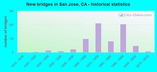
- New bridges - historical statistics
- 11900-1909
- 61910-1919
- 151920-1929
- 171930-1939
- 121940-1949
- 301950-1959
- 1011960-1969
- 2131970-1979
- 861980-1989
- 2061990-1999
- 492000-2009
- 82010-2019
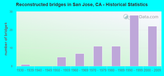
- Reconstructed bridges - Historical Statistics
- 11930-1939
- 01940-1949
- 51950-1959
- 71960-1969
- 111970-1979
- 111980-1989
- 281990-1999
- 222000-2009
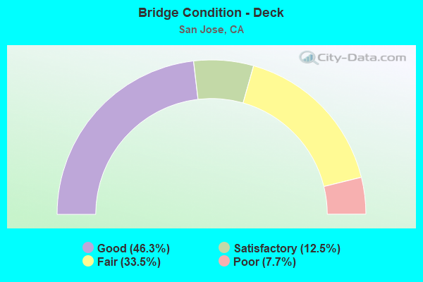
- Bridge Condition - Deck
- 46.3%Good
- 12.5%Satisfactory
- 33.5%Fair
- 7.7%Poor
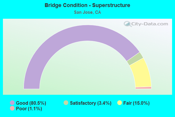
- Bridge Condition - Superstructure
- 80.5%Good
- 3.4%Satisfactory
- 15.0%Fair
- 1.1%Poor
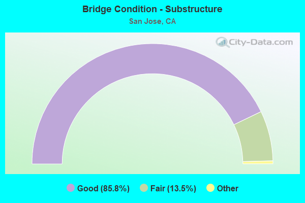
- Bridge Condition - Substructure
- 85.8%Good
- 13.5%Satisfactory
- 0.8%Fair
- 0.3%Poor
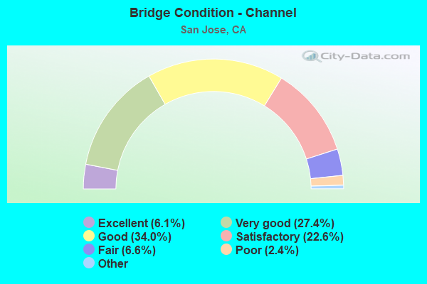
- Bridge Condition - Channel
- 6.1%Excellent
- 27.4%Very good
- 34.0%Good
- 22.6%Satisfactory
- 6.6%Fair
- 2.4%Poor
- 0.9%Serious
- 0.5%Critical
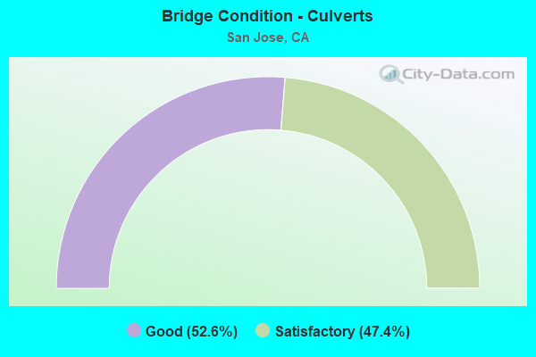
- Bridge Condition - Culverts
- 52.6%Good
- 47.4%Satisfactory
Find on map >> Show street view
Structure Number: 37 0037, Location: 04-SCL-101-40.19-SJS (Lat: 37.375131, Lng: -121.932478), Route carried "on" structure: US 101, Year Built: 1937, Year Reconstructed: 2005, Status: Open, Structure Length: 4.33m (14.21ft), Average Daily Traffic: 134,000 (year 2009), Truck Traffic: 4%, Average Future Daily Traffic: 213,576 (year 2038), Design Load: HS 20+Mod, Features Intersected: GUADALUPE RIVER
Minimum Vertical Clearance: 30+ m (98+ ft), Kilometerpoint: 40.190, Lanes on structure: 11, Base Highway Network: Yes (Inventory Route: 1, Subroute: 1), Owner: State Highway Agency, Approaching Roadway Width: 53.0m (173.9ft), Skew: 30 degrees, Material/Design: Concrete continuous, Design/Construction: Tee Beam, Number Of Spans In Main Unit: 4, Length of Maximum Span: 12.2m (40.0ft), Curb-To-Curb Width: 52.1m (170.9ft), Out-to-Out Width: 53.1m (174.2ft)
Condition: Deck: Good, Superstructure: Good, Substructure: Good, Channel: Good, Operating Rating: 30.8 metric tons, Method Used To Determine Operating Rating: Load and Resistance Factor Rating (LRFR) rating reported by rating factor(RF) method using HL-93 loadings, Inventory Rating: 23.7 metric tons, Method Used To Determine Inventory Rating: Load and Resistance Factor Rating (LRFR) rating reported by rating factor(RF) method using HL-93 loadings, Structural Evaluation: Somewhat better than minimum adequacy, Deck Geometry: Superior to present desirable criteria, Waterway Adequacy: Equal to present desirable criteria, Approach Roadway Alignment: Equal to present desirable criteria, Designated Inspection Frequency: Every 24 months, Inspection Date: Febuary 2021, Deck Structure Type: Concrete Cast-file-Place, Wearing Surface/Protective System: Wearing Surface: Bituminous
Find on map >> Show street view
Structure Number: 37 0037S, Location: 04-SCL-101-40.19-SJS (Lat: 37.375308, Lng: -121.932436), Route carried "on" structure: Ramp US 101, Year Built: 2005, Status: Open, Structure Length: 5.36m (17.59ft), Average Daily Traffic: 14,200 (year 2004), Truck Traffic: 5%, Average Future Daily Traffic: 18,534 (year 2043), Design Load: HS 20+Mod, Features Intersected: GUADALUPE RIVER
Minimum Vertical Clearance: 30+ m (98+ ft), Kilometerpoint: 40.190, Lanes on structure: 3, Owner: State Highway Agency, Approaching Roadway Width: 15.0m (49.2ft), Material/Design: Prestressed concrete continuous, Design/Construction: Box Beam or Girders - Multiple, Number Of Spans In Main Unit: 2, Length of Maximum Span: 26.1m (85.6ft), Curb-To-Curb Width: 14.4m (47.2ft), Out-to-Out Width: 15.3m (50.2ft)
Condition: Deck: Good, Superstructure: Good, Substructure: Good, Channel: Very good, Operating Rating: 54.1 metric tons, Method Used To Determine Operating Rating: Assigned rating based on Load Factor Design (LFD) reported in metric tons, Inventory Rating: 32.4 metric tons, Method Used To Determine Inventory Rating: Assigned rating based on Load Factor Design (LFD) reported in metric tons, Structural Evaluation: Better than present minimum criteria, Deck Geometry: Better than present minimum criteria, Waterway Adequacy: Equal to present desirable criteria, Approach Roadway Alignment: Equal to present desirable criteria, Designated Inspection Frequency: Every 24 months, Inspection Date: Febuary 2021, Deck Structure Type: Concrete Cast-file-Place
Find on map >> Show street view
Structure Number: 37 0039, Location: 04-SCL-101-36.69-SJS (Lat: 37.359883, Lng: -121.873439), Route carried "on" structure: US 101, Year Built: 1940, Year Reconstructed: 1990, Status: Open, Structure Length: 6.10m (20.01ft), Average Daily Traffic: 150,000 (year 2009), Truck Traffic: 7%, Average Future Daily Traffic: 165,344 (year 2038), Design Load: H 15, Features Intersected: COYOTE CREEK
Minimum Vertical Clearance: 30+ m (98+ ft), Kilometerpoint: 36.690, Lanes on structure: 8, Base Highway Network: Yes (Inventory Route: 1, Subroute: 1), Owner: State Highway Agency, Approaching Roadway Width: 44.0m (144.4ft), Skew: 33 degrees, Material/Design: Concrete continuous, Design/Construction: Tee Beam, Number Of Spans In Main Unit: 6, Length of Maximum Span: 13.3m (43.6ft), Curb-To-Curb Width: 43.0m (141.1ft), Out-to-Out Width: 44.7m (146.7ft)
Condition: Deck: Fair, Superstructure: Good, Substructure: Good, Channel: Good, Operating Rating: 25.3 metric tons, Method Used To Determine Operating Rating: Load and Resistance Factor Rating (LRFR) rating reported by rating factor(RF) method using HL-93 loadings, Inventory Rating: 19.4 metric tons, Method Used To Determine Inventory Rating: Load and Resistance Factor Rating (LRFR) rating reported by rating factor(RF) method using HL-93 loadings, Structural Evaluation: Meets minimum limits, Deck Geometry: Superior to present desirable criteria, Waterway Adequacy: Better than present minimum criteria, Approach Roadway Alignment: Equal to present desirable criteria, Designated Inspection Frequency: Every 24 months, Other Special Inspection Frequency: Every 48 months, Inspection Date: Febuary 2021, Other Special Inspection Date: March 2021, Deck Structure Type: Concrete Cast-file-Place, Wearing Surface/Protective System: Wearing Surface: Bituminous
Find on map >> Show street view
Structure Number: 37 004, Location: 04-SCL-101-51.37-PA (Lat: 37.440089, Lng: -122.113442), Route carried "on" structure: US 101, Year Built: 1960, Year Reconstructed: 2013, Status: Open, Structure Length: 2.58m (8.46ft), Average Daily Traffic: 187,000 (year 2009), Truck Traffic: 6%, Average Future Daily Traffic: 249,671 (year 2040), Design Load: HS 20+Mod, Features Intersected: MATADERO CREEK
Minimum Vertical Clearance: 30+ m (98+ ft), Kilometerpoint: 51.370, Lanes on structure: 8, Base Highway Network: Yes (Inventory Route: 1, Subroute: 1), Owner: State Highway Agency, Approaching Roadway Width: 46.6m (152.9ft), Skew: 30 degrees, Material/Design: Prestressed concrete, Design/Construction: Slab, Number Of Spans In Main Unit: 2, Length of Maximum Span: 12.1m (39.7ft), Curb-To-Curb Width: 46.6m (152.9ft), Out-to-Out Width: 48.1m (157.8ft)
Condition: Deck: Good, Superstructure: Good, Substructure: Good, Channel: Very good, Operating Rating: 63.5 metric tons, Method Used To Determine Operating Rating: Load Factor (LF), Inventory Rating: 32.4 metric tons, Method Used To Determine Inventory Rating: Load Factor (LF), Structural Evaluation: Better than present minimum criteria, Deck Geometry: Superior to present desirable criteria, Waterway Adequacy: Equal to present desirable criteria, Approach Roadway Alignment: Equal to present desirable criteria, Designated Inspection Frequency: Every 24 months, Inspection Date: Febuary 2022, Deck Structure Type: Concrete Cast-file-Place, Wearing Surface/Protective System: Wearing Surface: Bituminous
Find on map >> Show street view
Structure Number: 37 0048, Location: 04-SCL-101-R35.76-SJS (Lat: 37.349608, Lng: -121.861958), Route carried "on" structure: City street , Year Built: 1993, Status: Open, Structure Length: 7.07m (23.20ft), Average Daily Traffic: 28,500 (year 2009), Truck Traffic: 2%, Average Future Daily Traffic: 44,856 (year 2042), Design Load: HS 20, Features Intersected: U.S. HIGHWAY 101, Facility Carried by Structure: E SANTA CLARA ST
Minimum Vertical Clearance: 30+ m (98+ ft), Kilometerpoint: 0.000, Lanes on structure: 6, Lanes under structure: 10, Base Highway Network: Yes, Owner: State Highway Agency, Approaching Roadway Width: 27.0m (88.6ft), Skew: 20 degrees, Material/Design: Prestressed concrete continuous, Design/Construction: Box Beam or Girders - Multiple, Number Of Spans In Main Unit: 2, Length of Maximum Span: 35.9m (117.8ft), Curb or Sidewalk Widths: Left: 2.1m (6.9ft), Right: 2.1m (6.9ft), Curb-To-Curb Width: 26.5m (86.9ft), Out-to-Out Width: 32.6m (107.0ft)
Condition: Deck: Satisfactory, Superstructure: Good, Substructure: Good, Operating Rating: 54.1 metric tons, Method Used To Determine Operating Rating: Assigned rating based on Load Factor Design (LFD) reported in metric tons, Inventory Rating: 32.4 metric tons, Method Used To Determine Inventory Rating: Assigned rating based on Load Factor Design (LFD) reported in metric tons, Structural Evaluation: Better than present minimum criteria, Deck Geometry: Equal to present minimum criteria, Underclear: Equal to present minimum criteria, Approach Roadway Alignment: Equal to present minimum criteria, Length Of Structure Improvement: 7.13m (23.39ft), Designated Inspection Frequency: Every 24 months, Inspection Date: April 2020, Deck Structure Type: Concrete Cast-file-Place
Find on map >> Show street view
Structure Number: 37 0050G, Location: 04-SCL-280-L5.40-SJS (Lat: 37.318131, Lng: -121.938375), Route carried "on" structure: Ramp Interstate 280, Year Built: 1971, Status: Open, Structure Length: 35.60m (116.80ft), Average Daily Traffic: 28,000 (year 2002), Truck Traffic: 3%, Average Future Daily Traffic: 44,741 (year 2041), Design Load: HS 20, Features Intersected: I 280,SR 17,CONNS,MOORPK
Minimum Vertical Clearance: 30+ m (98+ ft), Kilometerpoint: 5.400, Lanes on structure: 2, Lanes under structure: 22, Base Highway Network: Yes (Inventory Route: 2, Subroute: 1), Owner: State Highway Agency, Approaching Roadway Width: 11.9m (39.0ft), Skew: 9 degrees, Material/Design: Steel, Design/Construction: Stringer/Multi-beam, Number Of Spans In Main Unit: 10, Length of Maximum Span: 47.4m (155.5ft), Curb-To-Curb Width: 11.9m (39.0ft), Out-to-Out Width: 12.5m (41.0ft)
Condition: Deck: Good, Superstructure: Good, Substructure: Fair, Operating Rating: 23.0 metric tons, Method Used To Determine Operating Rating: Load and Resistance Factor Rating (LRFR) rating reported by rating factor(RF) method using HL-93 loadings, Inventory Rating: 17.8 metric tons, Method Used To Determine Inventory Rating: Load and Resistance Factor Rating (LRFR) rating reported by rating factor(RF) method using HL-93 loadings, Structural Evaluation: Meets minimum limits, Deck Geometry: Superior to present desirable criteria, Underclear: Meets minimum limits, Approach Roadway Alignment: Equal to present desirable criteria, Designated Inspection Frequency: Every 24 months, Critical Feature Inspection Frequency: Every 24 months, Inspection Date: Febuary 2021, Critical Feature Inspection Date: November 2020, Deck Structure Type: Concrete Cast-file-Place
Find on map >> Show street view
Structure Number: 37 0084K, Location: 04-SCL-237-8.72-SJS (Lat: 37.422889, Lng: -121.926714), Route carried "on" structure: Ramp State highway 237, Year Built: 2000, Status: Open, Structure Length: 12.70m (41.67ft), Average Daily Traffic: 6,000 (year 2003), Truck Traffic: 9%, Average Future Daily Traffic: 16,410 (year 2042), Design Load: HS 20+Mod, Features Intersected: COYOTE CREEK
Minimum Vertical Clearance: 30+ m (98+ ft), Kilometerpoint: 8.720, Lanes on structure: 2, Owner: State Highway Agency, Approaching Roadway Width: 14.4m (47.2ft), Skew: 3 degrees, Material/Design: Prestressed concrete continuous, Design/Construction: Box Beam or Girders - Multiple, Number Of Spans In Main Unit: 3, Length of Maximum Span: 48.0m (157.5ft), Curb-To-Curb Width: 14.4m (47.2ft), Out-to-Out Width: 15.5m (50.9ft)
Condition: Deck: Good, Superstructure: Good, Substructure: Good, Channel: Very good, Operating Rating: 54.1 metric tons, Method Used To Determine Operating Rating: Assigned rating based on Load Factor Design (LFD) reported in metric tons, Inventory Rating: 32.4 metric tons, Method Used To Determine Inventory Rating: Assigned rating based on Load Factor Design (LFD) reported in metric tons, Structural Evaluation: Better than present minimum criteria, Deck Geometry: Superior to present desirable criteria, Waterway Adequacy: Equal to present desirable criteria, Approach Roadway Alignment: Equal to present desirable criteria, Designated Inspection Frequency: Every 24 months, Inspection Date: April 2020, Deck Structure Type: Concrete Cast-file-Place
Find on map >> Show street view
Structure Number: 37 0084L, Location: 04-SCL-237-8.72-SJS (Lat: 37.422661, Lng: -121.926967), Route carried "on" structure: State highway 237, Year Built: 1961, Year Reconstructed: 1994, Status: Open, Structure Length: 5.92m (19.42ft), Average Daily Traffic: 62,500 (year 2009), Truck Traffic: 6%, Average Future Daily Traffic: 78,316 (year 2040), Design Load: HS 20+Mod, Features Intersected: COYOTE CREEK
Minimum Vertical Clearance: 30+ m (98+ ft), Kilometerpoint: 8.720, Lanes on structure: 3, Base Highway Network: Yes (Inventory Route: 2, Subroute: 1), Owner: State Highway Agency, Approaching Roadway Width: 18.6m (61.0ft), Skew: 5 degrees, Material/Design: Concrete continuous, Design/Construction: Tee Beam, Number Of Spans In Main Unit: 3, Length of Maximum Span: 23.5m (77.1ft), Curb-To-Curb Width: 18.6m (61.0ft), Out-to-Out Width: 19.7m (64.6ft)
Condition: Deck: Poor, Superstructure: Good, Substructure: Good, Channel: Very good, Operating Rating: 54.1 metric tons, Method Used To Determine Operating Rating: Assigned rating based on Load Factor Design (LFD) reported in metric tons, Inventory Rating: 32.4 metric tons, Method Used To Determine Inventory Rating: Assigned rating based on Load Factor Design (LFD) reported in metric tons, Structural Evaluation: Better than present minimum criteria, Deck Geometry: Superior to present desirable criteria, Waterway Adequacy: Equal to present desirable criteria, Approach Roadway Alignment: Equal to present desirable criteria, Designated Inspection Frequency: Every 24 months, Inspection Date: April 2020, Deck Structure Type: Concrete Cast-file-Place
Find on map >> Show street view
Structure Number: 37 0084R, Location: 04-SCL-237-8.72-SJS (Lat: 37.422419, Lng: -121.927322), Route carried "on" structure: State highway 237, Year Built: 1972, Year Reconstructed: 1999, Status: Open, Structure Length: 5.91m (19.39ft), Average Daily Traffic: 62,500 (year 2009), Truck Traffic: 6%, Average Future Daily Traffic: 78,839 (year 2042), Design Load: HS 20, Features Intersected: COYOTE CREEK
Minimum Vertical Clearance: 30+ m (98+ ft), Kilometerpoint: 8.720, Lanes on structure: 4, Base Highway Network: Yes (Inventory Route: 2, Subroute: 1), Owner: State Highway Agency, Approaching Roadway Width: 20.1m (65.9ft), Skew: 5 degrees, Material/Design: Concrete continuous, Design/Construction: Tee Beam, Number Of Spans In Main Unit: 3, Length of Maximum Span: 23.5m (77.1ft), Curb-To-Curb Width: 20.1m (65.9ft), Out-to-Out Width: 21.2m (69.6ft)
Condition: Deck: Fair, Superstructure: Good, Substructure: Good, Channel: Good, Operating Rating: 94.3 metric tons, Method Used To Determine Operating Rating: Load Factor (LF), Inventory Rating: 56.7 metric tons, Method Used To Determine Inventory Rating: Load Factor (LF), Structural Evaluation: Better than present minimum criteria, Deck Geometry: Equal to present minimum criteria, Waterway Adequacy: Equal to present desirable criteria, Approach Roadway Alignment: Equal to present desirable criteria, Designated Inspection Frequency: Every 24 months, Inspection Date: April 2020, Deck Structure Type: Concrete Cast-file-Place
Find on map >> Show street view
Structure Number: 37 0084S, Location: 04-SCL-237-8.72-SJS (Lat: 37.422239, Lng: -121.927706), Route carried "on" structure: Ramp State highway 237, Year Built: 2000, Status: Open, Structure Length: 8.10m (26.57ft), Average Daily Traffic: 5,000 (year 2003), Truck Traffic: 9%, Average Future Daily Traffic: 6,564 (year 2042), Design Load: HS 20+Mod, Features Intersected: COYOTE CREEK
Minimum Vertical Clearance: 30+ m (98+ ft), Kilometerpoint: 8.720, Lanes on structure: 1, Owner: State Highway Agency, Approaching Roadway Width: 8.2m (26.9ft), Skew: 5 degrees, Material/Design: Prestressed concrete continuous, Design/Construction: Box Beam or Girders - Multiple, Number Of Spans In Main Unit: 3, Length of Maximum Span: 31.1m (102.0ft), Curb or Sidewalk Widths: Left: 0.0m, Right: 3.0m (9.8ft), Curb-To-Curb Width: 7.2m (23.6ft), Out-to-Out Width: 11.7m (38.4ft)
Condition: Deck: Good, Superstructure: Good, Substructure: Fair, Channel: Very good, Operating Rating: 54.1 metric tons, Method Used To Determine Operating Rating: Assigned rating based on Load Factor Design (LFD) reported in metric tons, Inventory Rating: 32.4 metric tons, Method Used To Determine Inventory Rating: Assigned rating based on Load Factor Design (LFD) reported in metric tons, Structural Evaluation: Somewhat better than minimum adequacy, Deck Geometry: Equal to present minimum criteria, Waterway Adequacy: Equal to present desirable criteria, Approach Roadway Alignment: Equal to present desirable criteria, Designated Inspection Frequency: Every 24 months, Inspection Date: April 2020, Deck Structure Type: Concrete Cast-file-Place
Find on map >> Show street view
Structure Number: 37 0097, Location: 04-SCL-101-36.37-SJS (Lat: 37.356617, Lng: -121.868900), Route carried "on" structure: US 101, Year Built: 1957, Year Reconstructed: 1992, Status: Open, Structure Length: 1.93m (6.33ft), Average Daily Traffic: 174,000 (year 1998), Truck Traffic: 7%, Average Future Daily Traffic: 305,093 (year 2043), Design Load: HS 20, Features Intersected: SILVER CREEK
Minimum Vertical Clearance: 30+ m (98+ ft), Kilometerpoint: 36.370, Lanes on structure: 9, Base Highway Network: Yes (Inventory Route: 1, Subroute: 1), Owner: State Highway Agency, Approaching Roadway Width: 46.3m (151.9ft), Skew: 31 degrees, Material/Design: Concrete continuous, Design/Construction: Slab, Number Of Spans In Main Unit: 3, Length of Maximum Span: 6.3m (20.7ft), Curb-To-Curb Width: 46.0m (150.9ft), Out-to-Out Width: 47.7m (156.5ft)
Condition: Deck: Satisfactory, Superstructure: Satisfactory, Substructure: Good, Channel: Very good, Operating Rating: 54.1 metric tons, Method Used To Determine Operating Rating: Assigned rating based on Load Factor Design (LFD) reported in metric tons, Inventory Rating: 32.4 metric tons, Method Used To Determine Inventory Rating: Assigned rating based on Load Factor Design (LFD) reported in metric tons, Structural Evaluation: Equal to present minimum criteria, Deck Geometry: Superior to present desirable criteria, Waterway Adequacy: Equal to present desirable criteria, Approach Roadway Alignment: Equal to present desirable criteria, Designated Inspection Frequency: Every 24 months, Inspection Date: Febuary 2021, Deck Structure Type: Concrete Cast-file-Place, Wearing Surface/Protective System: Wearing Surface: Bituminous
Find on map >> Show street view
Structure Number: 37 01, Location: 04-SCL-280-L5.17-SJS (Lat: 37.317111, Lng: -121.935986), Route carried "on" structure: County highway , Year Built: 1972, Status: Open, Structure Length: 8.26m (27.10ft), Average Daily Traffic: 4,500 (year 1998), Truck Traffic: 2%, Average Future Daily Traffic: 7,287 (year 2041), Design Load: HS 20, Features Intersected: INTERSTATE 280, Facility Carried by Structure: MAC ARTHUR AVENUE
Minimum Vertical Clearance: 30+ m (98+ ft), Kilometerpoint: 0.000, Lanes on structure: 2, Lanes under structure: 13, Owner: State Highway Agency, Approaching Roadway Width: 12.2m (40.0ft), Skew: 1 degrees, Material/Design: Concrete continuous, Design/Construction: Box Beam or Girders - Multiple, Number Of Spans In Main Unit: 3, Length of Maximum Span: 31.4m (103.0ft), Curb or Sidewalk Widths: Left: 1.8m (5.9ft), Right: 1.8m (5.9ft), Curb-To-Curb Width: 12.2m (40.0ft), Out-to-Out Width: 16.5m (54.1ft)
Condition: Deck: Good, Superstructure: Good, Substructure: Good, Operating Rating: 50.2 metric tons, Method Used To Determine Operating Rating: Load and Resistance Factor Rating (LRFR) rating reported by rating factor(RF) method using HL-93 loadings, Inventory Rating: 35.6 metric tons, Method Used To Determine Inventory Rating: Load and Resistance Factor Rating (LRFR) rating reported by rating factor(RF) method using HL-93 loadings, Structural Evaluation: Better than present minimum criteria, Deck Geometry: Equal to present minimum criteria, Underclear: Better than present minimum criteria, Approach Roadway Alignment: Equal to present desirable criteria, Designated Inspection Frequency: Every 24 months, Inspection Date: Febuary 2021, Deck Structure Type: Concrete Cast-file-Place, Wearing Surface/Protective System: Wearing Surface: Bituminous
Find on map >> Show street view
Structure Number: 37 0102R, Location: 04-SCL-101-29.83 (Lat: 37.278306, Lng: -121.805925), Route carried "on" structure: US 101, Year Built: 1947, Year Reconstructed: 1990, Status: Open, Structure Length: 12.28m (40.29ft), Average Daily Traffic: 64,000 (year 2009), Truck Traffic: 9%, Average Future Daily Traffic: 93,822 (year 2038), Design Load: HS 20, Features Intersected: COYOTE CREEK
Minimum Vertical Clearance: 30+ m (98+ ft), Kilometerpoint: 29.830, Lanes on structure: 4, Base Highway Network: Yes (Inventory Route: 1, Subroute: 1), Owner: State Highway Agency, Approaching Roadway Width: 21.0m (68.9ft), Skew: 3 degrees, Material/Design: Steel, Design/Construction: Stringer/Multi-beam, Number Of Spans In Main Unit: 4, Length of Maximum Span: 30.5m (100.1ft), Curb-To-Curb Width: 20.8m (68.2ft), Out-to-Out Width: 21.9m (71.9ft)
Condition: Deck: Poor, Superstructure: Good, Substructure: Good, Channel: Good, Operating Rating: 59.0 metric tons, Method Used To Determine Operating Rating: Load and Resistance Factor Rating (LRFR) rating reported by rating factor(RF) method using HL-93 loadings, Inventory Rating: 43.4 metric tons, Method Used To Determine Inventory Rating: Load and Resistance Factor Rating (LRFR) rating reported by rating factor(RF) method using HL-93 loadings, Structural Evaluation: Better than present minimum criteria, Deck Geometry: Equal to present minimum criteria, Waterway Adequacy: Better than present minimum criteria, Approach Roadway Alignment: Equal to present desirable criteria, Designated Inspection Frequency: Every 24 months, Critical Feature Inspection Frequency: Every 24 months, Inspection Date: January 2021, Critical Feature Inspection Date: June 2021, Deck Structure Type: Concrete Cast-file-Place
Find on map >> Show street view
Structure Number: 37 0108L, Location: 04-SCL-101-29.72-SJS (Lat: 37.276872, Lng: -121.805356), Route carried "on" structure: US 101, Year Built: 1947, Year Reconstructed: 1990, Status: Open, Structure Length: 4.02m (13.19ft), Average Daily Traffic: 64,000 (year 2009), Truck Traffic: 9%, Average Future Daily Traffic: 93,822 (year 2038), Design Load: HS 20, Features Intersected: COYOTE ROAD
Minimum Vertical Clearance: 30+ m (98+ ft), Kilometerpoint: 29.720, Lanes on structure: 4, Lanes under structure: 2, Base Highway Network: Yes (Inventory Route: 1, Subroute: 1), Owner: State Highway Agency, Approaching Roadway Width: 21.0m (68.9ft), Skew: 4 degrees, Material/Design: Steel continuous, Design/Construction: Stringer/Multi-beam, Number Of Spans In Main Unit: 3, Length of Maximum Span: 15.8m (51.8ft), Curb-To-Curb Width: 20.8m (68.2ft), Out-to-Out Width: 21.9m (71.9ft)
Condition: Deck: Fair, Superstructure: Good, Substructure: Good, Operating Rating: 36.6 metric tons, Method Used To Determine Operating Rating: Load and Resistance Factor Rating (LRFR) rating reported by rating factor(RF) method using HL-93 loadings, Inventory Rating: 28.2 metric tons, Method Used To Determine Inventory Rating: Load and Resistance Factor Rating (LRFR) rating reported by rating factor(RF) method using HL-93 loadings, Structural Evaluation: Better than present minimum criteria, Deck Geometry: Equal to present minimum criteria, Underclear: High priority of corrective action, Approach Roadway Alignment: Better than present minimum criteria, Designated Inspection Frequency: Every 24 months, Inspection Date: January 2021, Deck Structure Type: Concrete Cast-file-Place
Find on map >> Show street view
Structure Number: 37 0108R, Location: 04-SCL-101-29.72-SJS (Lat: 37.276753, Lng: -121.805000), Route carried "on" structure: US 101, Year Built: 1947, Year Reconstructed: 1990, Status: Open, Structure Length: 4.02m (13.19ft), Average Daily Traffic: 64,000 (year 2009), Truck Traffic: 9%, Average Future Daily Traffic: 93,822 (year 2038), Design Load: HS 20, Features Intersected: COYOTE ROAD
Minimum Vertical Clearance: 30+ m (98+ ft), Kilometerpoint: 29.720, Lanes on structure: 4, Lanes under structure: 2, Base Highway Network: Yes (Inventory Route: 1, Subroute: 1), Owner: State Highway Agency, Approaching Roadway Width: 21.0m (68.9ft), Skew: 4 degrees, Material/Design: Steel continuous, Design/Construction: Stringer/Multi-beam, Number Of Spans In Main Unit: 3, Length of Maximum Span: 15.8m (51.8ft), Curb-To-Curb Width: 20.8m (68.2ft), Out-to-Out Width: 21.9m (71.9ft)
Condition: Deck: Fair, Superstructure: Good, Substructure: Good, Operating Rating: 36.6 metric tons, Method Used To Determine Operating Rating: Load and Resistance Factor Rating (LRFR) rating reported by rating factor(RF) method using HL-93 loadings, Inventory Rating: 26.6 metric tons, Method Used To Determine Inventory Rating: Load and Resistance Factor Rating (LRFR) rating reported by rating factor(RF) method using HL-93 loadings, Structural Evaluation: Equal to present minimum criteria, Deck Geometry: Equal to present minimum criteria, Underclear: High priority of corrective action, Approach Roadway Alignment: Better than present minimum criteria, Designated Inspection Frequency: Every 24 months, Inspection Date: January 2021, Deck Structure Type: Concrete Cast-file-Place
Find on map >> Show street view
Structure Number: 37 0113, Location: 04-SCL-101-37.41-SJS (Lat: 37.362142, Lng: -121.885833), Route carried "on" structure: City street , Year Built: 1993, Status: Open, Structure Length: 6.29m (20.64ft), Average Daily Traffic: 15,564 (year 1999), Truck Traffic: 1%, Average Future Daily Traffic: 21,448 (year 2043), Design Load: HS 20+Mod, Features Intersected: U.S. HIGHWAY 101, Facility Carried by Structure: EAST HEDDING ST
Minimum Vertical Clearance: 30+ m (98+ ft), Kilometerpoint: 0.000, Lanes on structure: 5, Lanes under structure: 8, Base Highway Network: Yes, Owner: State Highway Agency, Approaching Roadway Width: 22.3m (73.2ft), Skew: 30 degrees, Material/Design: Prestressed concrete continuous, Design/Construction: Box Beam or Girders - Multiple, Number Of Spans In Main Unit: 2, Length of Maximum Span: 30.8m (101.0ft), Curb or Sidewalk Widths: Left: 1.5m (4.9ft), Right: 1.5m (4.9ft), Curb-To-Curb Width: 17.4m (57.1ft), Out-to-Out Width: 25.9m (85.0ft)
Condition: Deck: Satisfactory, Superstructure: Good, Substructure: Good, Operating Rating: 54.1 metric tons, Method Used To Determine Operating Rating: Assigned rating based on Load Factor Design (LFD) reported in metric tons, Inventory Rating: 32.4 metric tons, Method Used To Determine Inventory Rating: Assigned rating based on Load Factor Design (LFD) reported in metric tons, Structural Evaluation: Better than present minimum criteria, Deck Geometry: High priority of replacement, Underclear: High priority of corrective action, Approach Roadway Alignment: Better than present minimum criteria, Designated Inspection Frequency: Every 24 months, Inspection Date: Febuary 2021, Deck Structure Type: Concrete Cast-file-Place
Find on map >> Show street view
Structure Number: 37 0114, Location: 04-SCL-101-37.73-SJS (Lat: 37.362722, Lng: -121.891297), Route carried "on" structure: City street , Year Built: 1993, Status: Open, Structure Length: 7.04m (23.10ft), Average Daily Traffic: 27,072 (year 1999), Truck Traffic: 1%, Average Future Daily Traffic: 36,461 (year 2043), Design Load: HS 20+Mod, Features Intersected: U.S. HIGHWAY 101, Facility Carried by Structure: OAKLAND ROAD
Minimum Vertical Clearance: 30+ m (98+ ft), Kilometerpoint: 0.000, Lanes on structure: 7, Lanes under structure: 8, Base Highway Network: Yes, Owner: State Highway Agency, Approaching Roadway Width: 25.6m (84.0ft), Skew: 31 degrees, Material/Design: Prestressed concrete continuous, Design/Construction: Box Beam or Girders - Multiple, Number Of Spans In Main Unit: 2, Length of Maximum Span: 38.0m (124.7ft), Curb or Sidewalk Widths: Left: 1.5m (4.9ft), Right: 1.8m (5.9ft), Curb-To-Curb Width: 25.6m (84.0ft), Out-to-Out Width: 30.8m (101.0ft)
Condition: Deck: Satisfactory, Superstructure: Fair, Substructure: Good, Operating Rating: 54.1 metric tons, Method Used To Determine Operating Rating: Assigned rating based on Load Factor Design (LFD) reported in metric tons, Inventory Rating: 32.4 metric tons, Method Used To Determine Inventory Rating: Assigned rating based on Load Factor Design (LFD) reported in metric tons, Structural Evaluation: Somewhat better than minimum adequacy, Deck Geometry: Meets minimum limits, Underclear: High priority of corrective action, Approach Roadway Alignment: Better than present minimum criteria, Designated Inspection Frequency: Every 24 months, Inspection Date: Febuary 2021, Deck Structure Type: Concrete Cast-file-Place
Find on map >> Show street view
Structure Number: 37 0116, Location: 04-SCL-101-39.29-SJS (Lat: 37.372036, Lng: -121.917011), Route carried "on" structure: US 101, Year Built: 1959, Year Reconstructed: 1993, Status: Open, Structure Length: 6.52m (21.39ft), Average Daily Traffic: 144,000 (year 2009), Truck Traffic: 5%, Average Future Daily Traffic: 192,520 (year 2038), Design Load: HS 20+Mod, Features Intersected: NORTH 1ST ST & VTA LRT
Minimum Vertical Clearance: 30+ m (98+ ft), Kilometerpoint: 39.290, Lanes on structure: 9, Lanes under structure: 5, Base Highway Network: Yes (Inventory Route: 1, Subroute: 1), Owner: State Highway Agency, Approaching Roadway Width: 43.0m (141.1ft), Skew: 34 degrees, Material/Design: Steel, Design/Construction: Stringer/Multi-beam, Number Of Spans In Main Unit: 4, Length of Maximum Span: 21.9m (71.9ft), Curb-To-Curb Width: 47.8m (156.8ft), Out-to-Out Width: 49.3m (161.7ft)
Condition: Deck: Good, Superstructure: Good, Substructure: Good, Operating Rating: 48.9 metric tons, Method Used To Determine Operating Rating: Load Factor (LF), Inventory Rating: 29.2 metric tons, Method Used To Determine Inventory Rating: Load Factor (LF), Structural Evaluation: Better than present minimum criteria, Deck Geometry: Superior to present desirable criteria, Underclear: High priority of corrective action, Approach Roadway Alignment: Better than present minimum criteria, Designated Inspection Frequency: Every 24 months, Other Special Inspection Frequency: Every 48 months, Inspection Date: Febuary 2021, Other Special Inspection Date: June 2021, Deck Structure Type: Concrete Cast-file-Place, Wearing Surface/Protective System: Wearing Surface: Bituminous
Find on map >> Show street view
Structure Number: 37 0118, Location: 04-SCL-101-38.09-SJS (Lat: 37.363142, Lng: -121.897667), Route carried "on" structure: City street , Year Built: 1993, Status: Open, Structure Length: 12.01m (39.40ft), Average Daily Traffic: 16,600 (year 1998), Truck Traffic: 1%, Average Future Daily Traffic: 21,928 (year 2043), Design Load: HS 20+Mod, Features Intersected: U.S. HIGHWAY 101, Facility Carried by Structure: 10TH STREET
Minimum Vertical Clearance: 30+ m (98+ ft), Kilometerpoint: 0.000, Lanes on structure: 4, Lanes under structure: 11, Owner: State Highway Agency, Approaching Roadway Width: 16.6m (54.5ft), Skew: 3 degrees, Material/Design: Prestressed concrete continuous, Design/Construction: Box Beam or Girders - Multiple, Number Of Spans In Main Unit: 4, Length of Maximum Span: 42.7m (140.1ft), Curb or Sidewalk Widths: Left: 1.5m (4.9ft), Right: 1.5m (4.9ft), Curb-To-Curb Width: 16.5m (54.1ft), Out-to-Out Width: 20.1m (65.9ft)
Condition: Deck: Good, Superstructure: Good, Substructure: Good, Operating Rating: 54.1 metric tons, Method Used To Determine Operating Rating: Assigned rating based on Load Factor Design (LFD) reported in metric tons, Inventory Rating: 32.4 metric tons, Method Used To Determine Inventory Rating: Assigned rating based on Load Factor Design (LFD) reported in metric tons, Structural Evaluation: Better than present minimum criteria, Deck Geometry: Meets minimum limits, Underclear: High priority of corrective action, Approach Roadway Alignment: Equal to present desirable criteria, Designated Inspection Frequency: Every 24 months, Inspection Date: Febuary 2021, Deck Structure Type: Concrete Cast-file-Place
Find on map >> Show street view
Structure Number: 37 0119, Location: 04-SCL-880-4.06-SJS (Lat: 37.363631, Lng: -121.901844), Route carried "on" structure: Interstate 880, Year Built: 1997, Status: Open, Structure Length: 11.28m (37.01ft), Average Daily Traffic: 165,000 (year 2019), Truck Traffic: 6%, Average Future Daily Traffic: 237,462 (year 2041), Design Load: HS 20+Mod, Features Intersected: U.S. HIGHWAY 101
Minimum Vertical Clearance: 30+ m (98+ ft), Kilometerpoint: 4.060, Lanes on structure: 9, Lanes under structure: 12, Base Highway Network: Yes (Inventory Route: 8, Subroute: 1), Owner: State Highway Agency, Approaching Roadway Width: 47.6m (156.2ft), Skew: 30 degrees, Material/Design: Prestressed concrete continuous, Design/Construction: Box Beam or Girders - Multiple, Number Of Spans In Main Unit: 4, Length of Maximum Span: 36.6m (120.1ft), Curb-To-Curb Width: 47.6m (156.2ft), Out-to-Out Width: 49.3m (161.7ft)
Condition: Deck: Satisfactory, Superstructure: Good, Substructure: Good, Operating Rating: 54.1 metric tons, Method Used To Determine Operating Rating: Assigned rating based on Load Factor Design (LFD) reported in metric tons, Inventory Rating: 32.4 metric tons, Method Used To Determine Inventory Rating: Assigned rating based on Load Factor Design (LFD) reported in metric tons, Structural Evaluation: Better than present minimum criteria, Deck Geometry: Superior to present desirable criteria, Underclear: Equal to present minimum criteria, Approach Roadway Alignment: Equal to present desirable criteria, Length Of Structure Improvement: 11.28m (37.01ft), Designated Inspection Frequency: Every 24 months, Inspection Date: March 2021, Deck Structure Type: Concrete Cast-file-Place
Find on map >> Show street view
Structure Number: 37 012, Location: 04-SCL-880-4.28-SJS (Lat: 37.366894, Lng: -121.900925), Route carried "on" structure: Interstate 880, Year Built: 1960, Year Reconstructed: 2003, Status: Open, Structure Length: 5.91m (19.39ft), Average Daily Traffic: 150,000 (year 2019), Truck Traffic: 8%, Average Future Daily Traffic: 195,344 (year 2043), Design Load: HS 20, Features Intersected: UP RR & OLD BAYSHORE HWY
Minimum Vertical Clearance: 30+ m (98+ ft), Kilometerpoint: 4.280, Lanes on structure: 8, Lanes under structure: 4, Base Highway Network: Yes (Inventory Route: 8, Subroute: 1), Owner: State Highway Agency, Approaching Roadway Width: 40.6m (133.2ft), Skew: 32 degrees, Material/Design: Steel, Design/Construction: Stringer/Multi-beam, Number Of Spans In Main Unit: 3, Length of Maximum Span: 25.0m (82.0ft), Curb-To-Curb Width: 40.6m (133.2ft), Out-to-Out Width: 42.5m (139.4ft)
Condition: Deck: Fair, Superstructure: Good, Substructure: Good, Operating Rating: 39.5 metric tons, Method Used To Determine Operating Rating: Load and Resistance Factor Rating (LRFR) rating reported by rating factor(RF) method using HL-93 loadings, Inventory Rating: 30.5 metric tons, Method Used To Determine Inventory Rating: Load and Resistance Factor Rating (LRFR) rating reported by rating factor(RF) method using HL-93 loadings, Structural Evaluation: Better than present minimum criteria, Deck Geometry: Superior to present desirable criteria, Underclear: Equal to present minimum criteria, Approach Roadway Alignment: Equal to present desirable criteria, Designated Inspection Frequency: Every 24 months, Inspection Date: March 2021, Deck Structure Type: Concrete Cast-file-Place
Find on map >> Show street view
Structure Number: 37 0121, Location: 04-SCL-101-36.94-SJS (Lat: 37.360811, Lng: -121.877542), Route carried "on" structure: City street , Year Built: 1992, Status: Open, Structure Length: 8.38m (27.49ft), Average Daily Traffic: 19,300 (year 1998), Truck Traffic: 2%, Average Future Daily Traffic: 26,810 (year 2043), Design Load: HS 20+Mod, Features Intersected: U.S. HIGHWAY 101, Facility Carried by Structure: TAYLOR STREET
Minimum Vertical Clearance: 30+ m (98+ ft), Kilometerpoint: 0.000, Lanes on structure: 2, Lanes under structure: 8, Owner: State Highway Agency, Approaching Roadway Width: 17.4m (57.1ft), Skew: 31 degrees, Material/Design: Prestressed concrete continuous, Design/Construction: Box Beam or Girders - Multiple, Number Of Spans In Main Unit: 2, Length of Maximum Span: 42.7m (140.1ft), Curb or Sidewalk Widths: Left: 1.5m (4.9ft), Right: 1.5m (4.9ft), Curb-To-Curb Width: 17.7m (58.1ft), Out-to-Out Width: 22.6m (74.1ft)
Condition: Deck: Fair, Superstructure: Good, Substructure: Good, Operating Rating: 54.1 metric tons, Method Used To Determine Operating Rating: Assigned rating based on Load Factor Design (LFD) reported in metric tons, Inventory Rating: 32.4 metric tons, Method Used To Determine Inventory Rating: Assigned rating based on Load Factor Design (LFD) reported in metric tons, Structural Evaluation: Better than present minimum criteria, Deck Geometry: Superior to present desirable criteria, Underclear: Equal to present minimum criteria, Approach Roadway Alignment: Equal to present desirable criteria, Designated Inspection Frequency: Every 24 months, Inspection Date: Febuary 2021, Deck Structure Type: Concrete Cast-file-Place
Find on map >> Show street view
Structure Number: 37 0123, Location: 04-SCL-101-R36.12-SJS (Lat: 37.353800, Lng: -121.866369), Route carried "on" structure: City street , Year Built: 1993, Status: Open, Structure Length: 8.43m (27.66ft), Average Daily Traffic: 31,831 (year 1999), Truck Traffic: 1%, Average Future Daily Traffic: 42,896 (year 2043), Design Load: HS 20+Mod, Features Intersected: U.S. HIGHWAY 101, Facility Carried by Structure: MCKEE ROAD
Minimum Vertical Clearance: 30+ m (98+ ft), Kilometerpoint: 0.000, Lanes on structure: 5, Lanes under structure: 10, Base Highway Network: Yes, Owner: State Highway Agency, Approaching Roadway Width: 20.5m (67.3ft), Skew: 31 degrees, Material/Design: Prestressed concrete continuous, Design/Construction: Box Beam or Girders - Multiple, Number Of Spans In Main Unit: 2, Length of Maximum Span: 43.9m (144.0ft), Curb or Sidewalk Widths: Left: 1.5m (4.9ft), Right: 1.5m (4.9ft), Curb-To-Curb Width: 17.1m (56.1ft), Out-to-Out Width: 21.9m (71.9ft)
Condition: Deck: Satisfactory, Superstructure: Fair, Substructure: Good, Operating Rating: 54.1 metric tons, Method Used To Determine Operating Rating: Assigned rating based on Load Factor Design (LFD) reported in metric tons, Inventory Rating: 32.4 metric tons, Method Used To Determine Inventory Rating: Assigned rating based on Load Factor Design (LFD) reported in metric tons, Structural Evaluation: Somewhat better than minimum adequacy, Deck Geometry: High priority of replacement, Underclear: Equal to present minimum criteria, Approach Roadway Alignment: Equal to present desirable criteria, Length Of Structure Improvement: 8.41m (27.59ft), Designated Inspection Frequency: Every 24 months, Inspection Date: Febuary 2021, Deck Structure Type: Concrete Cast-file-Place
Find on map >> Show street view
Structure Number: 37 0125, Location: 04-SCL-880-0.88-SJS (Lat: 37.330172, Lng: -121.940333), Route carried "on" structure: Interstate 880, Year Built: 1959, Year Reconstructed: 1994, Status: Open, Structure Length: 3.88m (12.73ft), Average Daily Traffic: 163,000 (year 2017), Truck Traffic: 6%, Average Future Daily Traffic: 235,887 (year 2038), Design Load: HS 20, Features Intersected: HEDDING STREET
Minimum Vertical Clearance: 30+ m (98+ ft), Kilometerpoint: 0.880, Lanes on structure: 8, Lanes under structure: 4, Base Highway Network: Yes (Inventory Route: 8, Subroute: 1), Owner: State Highway Agency, Approaching Roadway Width: 40.2m (131.9ft), Skew: 21 degrees, Material/Design: Concrete, Design/Construction: Box Beam or Girders - Multiple, Number Of Spans In Main Unit: 1, Number Of Approach Spans: 2, Length of Maximum Span: 18.5m (60.7ft), Curb-To-Curb Width: 39.7m (130.2ft), Out-to-Out Width: 41.2m (135.2ft)
Condition: Deck: Satisfactory, Superstructure: Good, Substructure: Good, Operating Rating: 46.3 metric tons, Method Used To Determine Operating Rating: Load Factor (LF), Inventory Rating: 27.9 metric tons, Method Used To Determine Inventory Rating: Load Factor (LF), Structural Evaluation: Better than present minimum criteria, Deck Geometry: Superior to present desirable criteria, Underclear: Meets minimum limits, Approach Roadway Alignment: Equal to present desirable criteria, Designated Inspection Frequency: Every 24 months, Inspection Date: March 2021, Deck Structure Type: Concrete Cast-file-Place
Find on map >> Show street view
Structure Number: 37 0126, Location: 04-SCL-880-1.25-SJS (Lat: 37.334103, Lng: -121.936522), Route carried "on" structure: Interstate 880, Year Built: 1959, Year Reconstructed: 1996, Status: Open, Structure Length: 4.97m (16.31ft), Average Daily Traffic: 154,000 (year 2019), Truck Traffic: 3%, Average Future Daily Traffic: 188,584 (year 2041), Design Load: HS 20, Features Intersected: BASCOM AVE
Minimum Vertical Clearance: 30+ m (98+ ft), Kilometerpoint: 1.250, Lanes on structure: 8, Lanes under structure: 4, Base Highway Network: Yes (Inventory Route: 8, Subroute: 1), Owner: State Highway Agency, Approaching Roadway Width: 31.6m (103.7ft), Skew: 31 degrees, Material/Design: Concrete, Design/Construction: Tee Beam, Number Of Spans In Main Unit: 2, Number Of Approach Spans: 2, Length of Maximum Span: 12.8m (42.0ft), Curb-To-Curb Width: 31.6m (103.7ft), Out-to-Out Width: 34.1m (111.9ft)
Condition: Deck: Fair, Superstructure: Good, Substructure: Good, Operating Rating: 72.9 metric tons, Method Used To Determine Operating Rating: Load Factor (LF), Inventory Rating: 43.7 metric tons, Method Used To Determine Inventory Rating: Load Factor (LF), Structural Evaluation: Better than present minimum criteria, Deck Geometry: Meets minimum limits, Underclear: Meets minimum limits, Approach Roadway Alignment: Equal to present desirable criteria, Designated Inspection Frequency: Every 24 months, Inspection Date: March 2021, Deck Structure Type: Concrete Cast-file-Place
Find on map >> Show street view
Structure Number: 37 0127, Location: 04-SCL-880-1.73-SJS (Lat: 37.339267, Lng: -121.930575), Route carried "on" structure: City street C260, Year Built: 1960, Status: Open, Structure Length: 4.85m (15.91ft), Average Daily Traffic: 17,000 (year 2017), Truck Traffic: 1%, Average Future Daily Traffic: 21,377 (year 2042), Design Load: HS 20, Features Intersected: INTERSTATE 880, Facility Carried by Structure: PARK AVE
Minimum Vertical Clearance: 30+ m (98+ ft), Kilometerpoint: 0.000, Lanes on structure: 2, Lanes under structure: 8, Owner: State Highway Agency, Approaching Roadway Width: 14.0m (45.9ft), Material/Design: Concrete continuous, Design/Construction: Box Beam or Girders - Multiple, Number Of Spans In Main Unit: 2, Number Of Approach Spans: 2, Length of Maximum Span: 16.3m (53.5ft), Curb or Sidewalk Widths: Left: 1.6m (5.2ft), Right: 1.6m (5.2ft), Curb-To-Curb Width: 14.0m (45.9ft), Out-to-Out Width: 17.4m (57.1ft)
Condition: Deck: Good, Superstructure: Good, Substructure: Good, Operating Rating: 35.6 metric tons, Method Used To Determine Operating Rating: Load and Resistance Factor Rating (LRFR) rating reported by rating factor(RF) method using HL-93 loadings, Inventory Rating: 27.5 metric tons, Method Used To Determine Inventory Rating: Load and Resistance Factor Rating (LRFR) rating reported by rating factor(RF) method using HL-93 loadings, Structural Evaluation: Equal to present minimum criteria, Deck Geometry: Superior to present desirable criteria, Underclear: High priority of corrective action, Approach Roadway Alignment: Equal to present desirable criteria, Designated Inspection Frequency: Every 24 months, Inspection Date: March 2021, Deck Structure Type: Concrete Cast-file-Place, Wearing Surface/Protective System: Wearing Surface: Bituminous
Find on map >> Show street view
Structure Number: 37 0128, Location: 04-SCL-082-9.90-SJS (Lat: 37.342639, Lng: -121.926336), Route carried "on" structure: State highway 82, Year Built: 1960, Status: Open, Structure Length: 6.13m (20.11ft), Average Daily Traffic: 14,700 (year 2009), Truck Traffic: 3%, Average Future Daily Traffic: 25,810 (year 2042), Design Load: HS 20, Features Intersected: INTERSTATE 880
Minimum Vertical Clearance: 30+ m (98+ ft), Kilometerpoint: 9.900, Lanes on structure: 4, Lanes under structure: 8, Base Highway Network: Yes (, Subroute: 1), Owner: State Highway Agency, Approaching Roadway Width: 24.4m (80.1ft), Skew: 21 degrees, Material/Design: Concrete continuous, Design/Construction: Box Beam or Girders - Multiple, Number Of Spans In Main Unit: 2, Number Of Approach Spans: 2, Length of Maximum Span: 21.0m (68.9ft), Curb or Sidewalk Widths: Left: 1.8m (5.9ft), Right: 1.8m (5.9ft), Curb-To-Curb Width: 22.6m (74.1ft), Out-to-Out Width: 28.7m (94.2ft)
Condition: Deck: Satisfactory, Superstructure: Good, Substructure: Good, Operating Rating: 31.1 metric tons, Method Used To Determine Operating Rating: Load and Resistance Factor Rating (LRFR) rating reported by rating factor(RF) method using HL-93 loadings, Inventory Rating: 24.0 metric tons, Method Used To Determine Inventory Rating: Load and Resistance Factor Rating (LRFR) rating reported by rating factor(RF) method using HL-93 loadings, Structural Evaluation: Somewhat better than minimum adequacy, Deck Geometry: Superior to present desirable criteria, Underclear: High priority of corrective action, Approach Roadway Alignment: Equal to present desirable criteria, Designated Inspection Frequency: Every 24 months, Inspection Date: April 2020, Deck Structure Type: Concrete Cast-file-Place
Find on map >> Show street view
Structure Number: 37 0129, Location: 04-SCL-880-2.38-SJS (Lat: 37.345747, Lng: -121.922158), Route carried "on" structure: Interstate 880, Year Built: 1992, Status: Open, Structure Length: 6.46m (21.19ft), Average Daily Traffic: 165,000 (year 2019), Truck Traffic: 10%, Average Future Daily Traffic: 250,610 (year 2041), Design Load: HS 20+Mod, Features Intersected: CALTRAIN & UP RR
Minimum Vertical Clearance: 30+ m (98+ ft), Kilometerpoint: 2.380, Lanes on structure: 8, Base Highway Network: Yes (Inventory Route: 8, Subroute: 1), Owner: State Highway Agency, Approaching Roadway Width: 41.4m (135.8ft), Skew: 31 degrees, Material/Design: Prestressed concrete, Design/Construction: Stringer/Multi-beam, Number Of Spans In Main Unit: 1, Number Of Approach Spans: 2, Length of Maximum Span: 38.4m (126.0ft), Curb-To-Curb Width: 41.4m (135.8ft), Out-to-Out Width: 43.0m (141.1ft)
Condition: Deck: Good, Superstructure: Good, Substructure: Good, Operating Rating: 54.1 metric tons, Method Used To Determine Operating Rating: Assigned rating based on Load Factor Design (LFD) reported in metric tons, Inventory Rating: 32.4 metric tons, Method Used To Determine Inventory Rating: Assigned rating based on Load Factor Design (LFD) reported in metric tons, Structural Evaluation: Better than present minimum criteria, Deck Geometry: Superior to present desirable criteria, Underclear: Better than present minimum criteria, Approach Roadway Alignment: Equal to present desirable criteria, Designated Inspection Frequency: Every 24 months, Inspection Date: March 2021, Deck Structure Type: Concrete Cast-file-Place
Find on map >> Show street view
Structure Number: 37 0131, Location: 04-SCL-017-13.93-SJS (Lat: 37.317058, Lng: -121.940069), Route carried "on" structure: State highway 17, Year Built: 1971, Status: Open, Structure Length: 5.94m (19.49ft), Average Daily Traffic: 184,800 (year 2017), Truck Traffic: 4%, Average Future Daily Traffic: 240,000 (year 2038), Design Load: HS 20+Mod, Features Intersected: INTERSTATE 280 & RAMPS
Minimum Vertical Clearance: 4.95m (16.24ft), Kilometerpoint: 13.930, Lanes on structure: 7, Lanes under structure: 9, Base Highway Network: Yes (, Subroute: 1), Owner: State Highway Agency, Approaching Roadway Width: 39.0m (128.0ft), Skew: 20 degrees, Material/Design: Steel continuous, Design/Construction: Stringer/Multi-beam, Number Of Spans In Main Unit: 2, Length of Maximum Span: 30.2m (99.1ft), Curb-To-Curb Width: 37.8m (124.0ft), Out-to-Out Width: 39.4m (129.3ft)
Condition: Deck: Fair, Superstructure: Good, Substructure: Good, Operating Rating: 52.2 metric tons, Method Used To Determine Operating Rating: Load Factor (LF), Inventory Rating: 31.1 metric tons, Method Used To Determine Inventory Rating: Load Factor (LF), Structural Evaluation: Better than present minimum criteria, Deck Geometry: Somewhat better than minimum adequacy, Underclear: High priority of corrective action, Approach Roadway Alignment: Equal to present desirable criteria, Designated Inspection Frequency: Every 24 months, Inspection Date: July 2020, Deck Structure Type: Concrete Cast-file-Place
Find on map >> Show street view
Structure Number: 37 0131F, Location: 04-SCL-017-13.93-SJS (Lat: 37.317056, Lng: -121.940667), Route carried "on" structure: Ramp State highway 17, Year Built: 1971, Status: Open, Structure Length: 5.91m (19.39ft), Average Daily Traffic: 24,400 (year 2011), Truck Traffic: 2%, Average Future Daily Traffic: 31,700 (year 2038), Design Load: HS 20+Mod, Features Intersected: INTERSTATE 280 & RAMPS
Minimum Vertical Clearance: 5.28m (17.32ft), Kilometerpoint: 13.930, Lanes on structure: 2, Lanes under structure: 9, Base Highway Network: Yes, Owner: State Highway Agency, Approaching Roadway Width: 11.3m (37.1ft), Material/Design: Steel continuous, Design/Construction: Stringer/Multi-beam, Number Of Spans In Main Unit: 2, Length of Maximum Span: 30.7m (100.7ft), Curb-To-Curb Width: 9.8m (32.2ft), Out-to-Out Width: 10.4m (34.1ft)
Condition: Deck: Fair, Superstructure: Good, Substructure: Good, Operating Rating: 63.2 metric tons, Method Used To Determine Operating Rating: Load Factor (LF), Inventory Rating: 37.9 metric tons, Method Used To Determine Inventory Rating: Load Factor (LF), Structural Evaluation: Better than present minimum criteria, Deck Geometry: Equal to present minimum criteria, Underclear: Meets minimum limits, Approach Roadway Alignment: Equal to present desirable criteria, Designated Inspection Frequency: Every 24 months, Inspection Date: July 2020, Deck Structure Type: Concrete Cast-file-Place
Find on map >> Show street view
Structure Number: 37 0131G, Location: 04-SCL-017-13.93-SJS (Lat: 37.317061, Lng: -121.939892), Route carried "on" structure: Ramp State highway 17, Year Built: 1971, Status: Open, Structure Length: 5.94m (19.49ft), Average Daily Traffic: 21,400 (year 2010), Truck Traffic: 2%, Average Future Daily Traffic: 27,800 (year 2038), Design Load: HS 20+Mod, Features Intersected: INTERSTATE 280 & RAMPS
Minimum Vertical Clearance: 5.08m (16.67ft), Kilometerpoint: 13.930, Lanes on structure: 2, Lanes under structure: 9, Base Highway Network: Yes, Owner: State Highway Agency, Approaching Roadway Width: 6.7m (22.0ft), Material/Design: Steel continuous, Design/Construction: Stringer/Multi-beam, Number Of Spans In Main Unit: 2, Length of Maximum Span: 30.2m (99.1ft), Curb-To-Curb Width: 8.3m (27.2ft), Out-to-Out Width: 8.9m (29.2ft)
Condition: Deck: Fair, Superstructure: Good, Substructure: Good, Operating Rating: 63.2 metric tons, Method Used To Determine Operating Rating: Load Factor (LF), Inventory Rating: 37.9 metric tons, Method Used To Determine Inventory Rating: Load Factor (LF), Structural Evaluation: Better than present minimum criteria, Deck Geometry: High priority of corrective action, Underclear: High priority of corrective action, Approach Roadway Alignment: Equal to present desirable criteria, Designated Inspection Frequency: Every 24 months, Inspection Date: July 2020, Deck Structure Type: Concrete Cast-file-Place
Find on map >> Show street view
Structure Number: 37 0132, Location: 04-SCL-880-0.41-SJS (Lat: 37.323167, Lng: -121.941208), Route carried "on" structure: City street C028, Year Built: 1954, Year Reconstructed: 2014, Status: Open, Structure Length: 9.44m (30.97ft), Average Daily Traffic: 25,000 (year 2017), Truck Traffic: 3%, Average Future Daily Traffic: 48,097 (year 2043), Features Intersected: INTERSTATE 880, Facility Carried by Structure: STEVENS CREEK BLVD
Minimum Vertical Clearance: 30+ m (98+ ft), Kilometerpoint: 0.000, Lanes on structure: 7, Lanes under structure: 9, Base Highway Network: Yes, Owner: State Highway Agency, Approaching Roadway Width: 31.7m (104.0ft), Skew: 20 degrees, Material/Design: Concrete continuous, Design/Construction: Box Beam or Girders - Multiple, Number Of Spans In Main Unit: 2, Number Of Approach Spans: 2, Length of Maximum Span: 24.9m (81.7ft), Curb or Sidewalk Widths: Left: 2.1m (6.9ft), Right: 2.1m (6.9ft), Curb-To-Curb Width: 31.7m (104.0ft), Out-to-Out Width: 37.2m (122.0ft)
Condition: Deck: Fair, Superstructure: Fair, Substructure: Good, Operating Rating: 54.1 metric tons, Method Used To Determine Operating Rating: Field evaluation and documented engineering judgment, Inventory Rating: 32.4 metric tons, Method Used To Determine Inventory Rating: Field evaluation and documented engineering judgment, Structural Evaluation: Somewhat better than minimum adequacy, Deck Geometry: Superior to present desirable criteria, Underclear: High priority of corrective action, Approach Roadway Alignment: Equal to present desirable criteria, Designated Inspection Frequency: Every 24 months, Inspection Date: March 2021, Deck Structure Type: Concrete Cast-file-Place, Wearing Surface/Protective System: Wearing Surface: Integral Concrete
Find on map >> Show street view
Structure Number: 37 0139, Location: 04-SCL-017-13.85-SJS (Lat: 37.315994, Lng: -121.940081), Route carried "on" structure: State highway 17, Year Built: 1959, Year Reconstructed: 1971, Status: Open, Structure Length: 3.96m (12.99ft), Average Daily Traffic: 184,800 (year 2017), Truck Traffic: 4%, Average Future Daily Traffic: 240,000 (year 2038), Design Load: HS 20+Mod, Features Intersected: MOORPARK AVENUE
Minimum Vertical Clearance: 30+ m (98+ ft), Kilometerpoint: 13.850, Lanes on structure: 8, Lanes under structure: 4, Base Highway Network: Yes (, Subroute: 1), Owner: State Highway Agency, Approaching Roadway Width: 43.0m (141.1ft), Skew: 20 degrees, Material/Design: Steel, Design/Construction: Stringer/Multi-beam, Number Of Spans In Main Unit: 1, Number Of Approach Spans: 2, Length of Maximum Span: 20.4m (66.9ft), Curb-To-Curb Width: 43.0m (141.1ft), Out-to-Out Width: 44.3m (145.3ft)
Condition: Deck: Good, Superstructure: Good, Substructure: Good, Operating Rating: 54.1 metric tons, Method Used To Determine Operating Rating: Field evaluation and documented engineering judgment, Inventory Rating: 32.4 metric tons, Method Used To Determine Inventory Rating: Field evaluation and documented engineering judgment, Structural Evaluation: Better than present minimum criteria, Deck Geometry: Superior to present desirable criteria, Underclear: High priority of corrective action, Approach Roadway Alignment: Equal to present desirable criteria, Designated Inspection Frequency: Every 24 months, Inspection Date: July 2020, Deck Structure Type: Concrete Cast-file-Place, Wearing Surface/Protective System: Wearing Surface: Bituminous
Find on map >> Show street view
Structure Number: 37 0139G, Location: 04-SCL-017-13.85-SJS (Lat: 37.315992, Lng: -121.939850), Route carried "on" structure: Ramp State highway 17, Year Built: 1971, Status: Open, Structure Length: 2.35m (7.71ft), Average Daily Traffic: 26,500 (year 2010), Truck Traffic: 2%, Average Future Daily Traffic: 34,500 (year 2038), Design Load: HS 20+Mod, Features Intersected: MOORPARK AVENUE
Minimum Vertical Clearance: 30+ m (98+ ft), Kilometerpoint: 13.850, Lanes on structure: 2, Lanes under structure: 4, Base Highway Network: Yes, Owner: State Highway Agency, Approaching Roadway Width: 11.9m (39.0ft), Skew: 2 degrees, Material/Design: Steel, Design/Construction: Stringer/Multi-beam, Number Of Spans In Main Unit: 1, Length of Maximum Span: 21.9m (71.9ft), Curb-To-Curb Width: 11.9m (39.0ft), Out-to-Out Width: 12.5m (41.0ft)
Condition: Deck: Fair, Superstructure: Good, Substructure: Good, Operating Rating: 85.2 metric tons, Method Used To Determine Operating Rating: Load Factor (LF), Inventory Rating: 50.9 metric tons, Method Used To Determine Inventory Rating: Load Factor (LF), Structural Evaluation: Better than present minimum criteria, Deck Geometry: Superior to present desirable criteria, Underclear: Meets minimum limits, Approach Roadway Alignment: Equal to present desirable criteria, Designated Inspection Frequency: Every 24 months, Inspection Date: July 2020, Deck Structure Type: Concrete Cast-file-Place
Find on map >> Show street view
Structure Number: 37 0141, Location: 04-SCL-880-3.78-SJS (Lat: 37.360547, Lng: -121.904711), Route carried "on" structure: Interstate 880, Year Built: 1960, Year Reconstructed: 2003, Status: Open, Structure Length: 4.11m (13.48ft), Average Daily Traffic: 165,000 (year 2019), Truck Traffic: 6%, Average Future Daily Traffic: 242,251 (year 2041), Design Load: HS 20, Features Intersected: NORTH FOURTH STREET
Minimum Vertical Clearance: 30+ m (98+ ft), Kilometerpoint: 3.780, Lanes on structure: 9, Lanes under structure: 4, Base Highway Network: Yes (Inventory Route: 8, Subroute: 1), Owner: State Highway Agency, Approaching Roadway Width: 40.1m (131.6ft), Skew: 32 degrees, Material/Design: Steel, Design/Construction: Stringer/Multi-beam, Number Of Spans In Main Unit: 1, Number Of Approach Spans: 2, Length of Maximum Span: 21.6m (70.9ft), Curb-To-Curb Width: 40.1m (131.6ft), Out-to-Out Width: 42.0m (137.8ft)
Condition: Deck: Poor, Superstructure: Good, Substructure: Good, Operating Rating: 33.4 metric tons, Method Used To Determine Operating Rating: Load and Resistance Factor Rating (LRFR) rating reported by rating factor(RF) method using HL-93 loadings, Inventory Rating: 25.9 metric tons, Method Used To Determine Inventory Rating: Load and Resistance Factor Rating (LRFR) rating reported by rating factor(RF) method using HL-93 loadings, Structural Evaluation: Equal to present minimum criteria, Deck Geometry: Better than present minimum criteria, Underclear: Meets minimum limits, Approach Roadway Alignment: Equal to present desirable criteria, Length Of Structure Improvement: 4.11m (13.48ft), Designated Inspection Frequency: Every 24 months, Inspection Date: March 2021, Bridge Improvement Cost: $1,726,000, Roadway Improvement Cost: $345,000, Total Project Cost: $2,899,000 ( Estimate for 2020), Deck Structure Type: Concrete Cast-file-Place
Find on map >> Show street view
Structure Number: 37 0142, Location: 04-SCL-101-34.55-SJS (Lat: 37.335486, Lng: -121.848725), Route carried "on" structure: City street C020, Year Built: 1967, Status: Open, Structure Length: 9.88m (32.41ft), Average Daily Traffic: 26,538 (year 2000), Truck Traffic: 1%, Average Future Daily Traffic: 37,784 (year 2043), Design Load: H 20, Features Intersected: U.S. HIGHWAY 101, Facility Carried by Structure: STORY ROAD
Minimum Vertical Clearance: 30+ m (98+ ft), Kilometerpoint: 0.000, Lanes on structure: 6, Lanes under structure: 12, Base Highway Network: Yes, Owner: State Highway Agency, Approaching Roadway Width: 35.4m (116.1ft), Skew: 20 degrees, Material/Design: Prestressed concrete, Design/Construction: Stringer/Multi-beam, Number Of Spans In Main Unit: 4, Length of Maximum Span: 24.7m (81.0ft), Curb or Sidewalk Widths: Left: 1.5m (4.9ft), Right: 1.5m (4.9ft), Curb-To-Curb Width: 31.7m (104.0ft), Out-to-Out Width: 39.0m (128.0ft)
Condition: Deck: Poor, Superstructure: Good, Substructure: Good, Operating Rating: 52.8 metric tons, Method Used To Determine Operating Rating: Load and Resistance Factor Rating (LRFR) rating reported by rating factor(RF) method using HL-93 loadings, Inventory Rating: 33.7 metric tons, Method Used To Determine Inventory Rating: Load and Resistance Factor Rating (LRFR) rating reported by rating factor(RF) method using HL-93 loadings, Structural Evaluation: Better than present minimum criteria, Deck Geometry: Superior to present desirable criteria, Underclear: Meets minimum limits, Approach Roadway Alignment: Equal to present desirable criteria, Designated Inspection Frequency: Every 24 months, Inspection Date: January 2021, Deck Structure Type: Concrete Cast-file-Place
Find on map >> Show street view
Structure Number: 37 0159K, Location: 04-SCL-237-R5.68-SJS (Lat: 37.414858, Lng: -121.980458), Route carried "on" structure: Ramp State highway 237, Year Built: 1994, Status: Open, Structure Length: 6.19m (20.31ft), Average Daily Traffic: 4,500 (year 1998), Truck Traffic: 5%, Average Future Daily Traffic: 8,734 (year 2043), Design Load: HS 20+Mod, Features Intersected: SAN TOMAS AQUINO CREEK
Minimum Vertical Clearance: 30+ m (98+ ft), Kilometerpoint: 5.680, Lanes on structure: 1, Base Highway Network: Yes, Owner: State Highway Agency, Approaching Roadway Width: 7.3m (24.0ft), Skew: 2 degrees, Material/Design: Concrete continuous, Design/Construction: Slab, Number Of Spans In Main Unit: 5, Length of Maximum Span: 12.8m (42.0ft), Curb-To-Curb Width: 7.3m (24.0ft), Out-to-Out Width: 8.4m (27.6ft)
Condition: Deck: Good, Superstructure: Good, Substructure: Good, Channel: Very good, Operating Rating: 29.5 metric tons, Method Used To Determine Operating Rating: Load and Resistance Factor Rating (LRFR) rating reported by rating factor(RF) method using HL-93 loadings, Inventory Rating: 22.7 metric tons, Method Used To Determine Inventory Rating: Load and Resistance Factor Rating (LRFR) rating reported by rating factor(RF) method using HL-93 loadings, Structural Evaluation: Somewhat better than minimum adequacy, Deck Geometry: Better than present minimum criteria, Waterway Adequacy: Equal to present desirable criteria, Approach Roadway Alignment: Equal to present desirable criteria, Designated Inspection Frequency: Every 24 months, Inspection Date: April 2021, Deck Structure Type: Concrete Cast-file-Place
Find on map >> Show street view
Structure Number: 37 0159L, Location: 04-SCL-237-R5.68-SJS (Lat: 37.414606, Lng: -121.980386), Route carried "on" structure: State highway 237, Year Built: 1994, Status: Open, Structure Length: 6.07m (19.91ft), Average Daily Traffic: 62,500 (year 2009), Truck Traffic: 5%, Average Future Daily Traffic: 78,056 (year 2039), Design Load: HS 20+Mod, Features Intersected: SAN TOMAS AQUINO CREEK
Minimum Vertical Clearance: 30+ m (98+ ft), Kilometerpoint: 5.680, Lanes on structure: 3, Base Highway Network: Yes (Inventory Route: 2, Subroute: 1), Owner: State Highway Agency, Approaching Roadway Width: 17.1m (56.1ft), Skew: 1 degrees, Material/Design: Concrete continuous, Design/Construction: Slab, Number Of Spans In Main Unit: 5, Length of Maximum Span: 12.5m (41.0ft), Curb-To-Curb Width: 17.1m (56.1ft), Out-to-Out Width: 18.1m (59.4ft)
Condition: Deck: Good, Superstructure: Good, Substructure: Good, Channel: Very good, Operating Rating: 54.1 metric tons, Method Used To Determine Operating Rating: Assigned rating based on Load Factor Design (LFD) reported in metric tons, Inventory Rating: 32.4 metric tons, Method Used To Determine Inventory Rating: Assigned rating based on Load Factor Design (LFD) reported in metric tons, Structural Evaluation: Better than present minimum criteria, Deck Geometry: Equal to present minimum criteria, Waterway Adequacy: Equal to present desirable criteria, Approach Roadway Alignment: Equal to present desirable criteria, Designated Inspection Frequency: Every 24 months, Inspection Date: April 2021, Deck Structure Type: Concrete Cast-file-Place
Find on map >> Show street view
Structure Number: 37 0159R, Location: 04-SCL-237-R5.68-SJS (Lat: 37.414347, Lng: -121.980331), Route carried "on" structure: State highway 237, Year Built: 1994, Status: Open, Structure Length: 6.07m (19.91ft), Average Daily Traffic: 62,500 (year 2009), Truck Traffic: 5%, Average Future Daily Traffic: 78,056 (year 2039), Design Load: HS 20+Mod, Features Intersected: SAN TOMAS AQUINO CREEK
Minimum Vertical Clearance: 30+ m (98+ ft), Kilometerpoint: 5.680, Lanes on structure: 3, Base Highway Network: Yes (Inventory Route: 2, Subroute: 1), Owner: State Highway Agency, Approaching Roadway Width: 17.1m (56.1ft), Skew: 1 degrees, Material/Design: Concrete continuous, Design/Construction: Slab, Number Of Spans In Main Unit: 5, Length of Maximum Span: 12.5m (41.0ft), Curb-To-Curb Width: 17.1m (56.1ft), Out-to-Out Width: 18.1m (59.4ft)
Condition: Deck: Good, Superstructure: Good, Substructure: Good, Channel: Very good, Operating Rating: 54.1 metric tons, Method Used To Determine Operating Rating: Assigned rating based on Load Factor Design (LFD) reported in metric tons, Inventory Rating: 32.4 metric tons, Method Used To Determine Inventory Rating: Assigned rating based on Load Factor Design (LFD) reported in metric tons, Structural Evaluation: Better than present minimum criteria, Deck Geometry: Equal to present minimum criteria, Waterway Adequacy: Equal to present desirable criteria, Approach Roadway Alignment: Equal to present desirable criteria, Designated Inspection Frequency: Every 24 months, Inspection Date: April 2021, Deck Structure Type: Concrete Cast-file-Place