Bridge Statistics for San Jose, California (CA)
Condition, Traffic, Stress, Structural Evaluation, Project Costs
- National Bridge Inventory (NBI) Statistics
- 744Number of bridges
- 11,818ft / 3,602mTotal length
- $39,465,000Total costs
- 35,474,087Total average daily traffic
- 1,567,044Total average daily truck traffic
- National Bridge Inventory (NBI) Registered Bridges for San Jose
- No street view available for this location
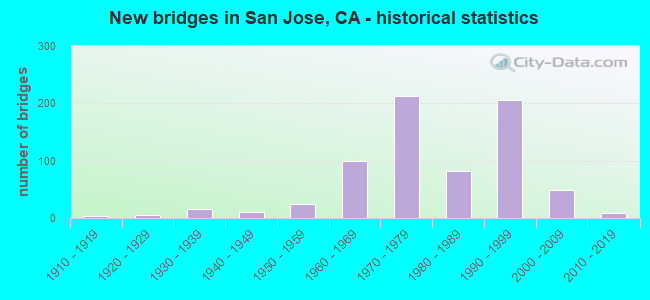
- New bridges - historical statistics
- 11900-1909
- 61910-1919
- 151920-1929
- 171930-1939
- 121940-1949
- 301950-1959
- 1011960-1969
- 2131970-1979
- 861980-1989
- 2061990-1999
- 492000-2009
- 82010-2019
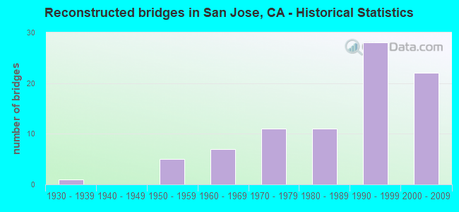
- Reconstructed bridges - Historical Statistics
- 11930-1939
- 01940-1949
- 51950-1959
- 71960-1969
- 111970-1979
- 111980-1989
- 281990-1999
- 222000-2009
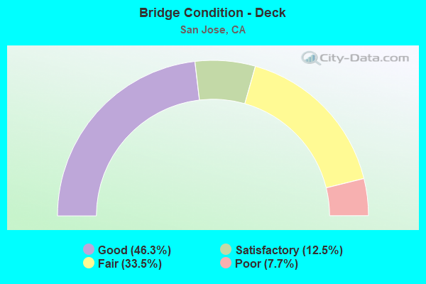
- Bridge Condition - Deck
- 46.3%Good
- 12.5%Satisfactory
- 33.5%Fair
- 7.7%Poor
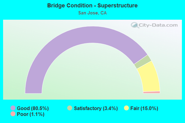
- Bridge Condition - Superstructure
- 80.5%Good
- 3.4%Satisfactory
- 15.0%Fair
- 1.1%Poor
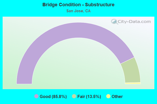
- Bridge Condition - Substructure
- 85.8%Good
- 13.5%Satisfactory
- 0.8%Fair
- 0.3%Poor
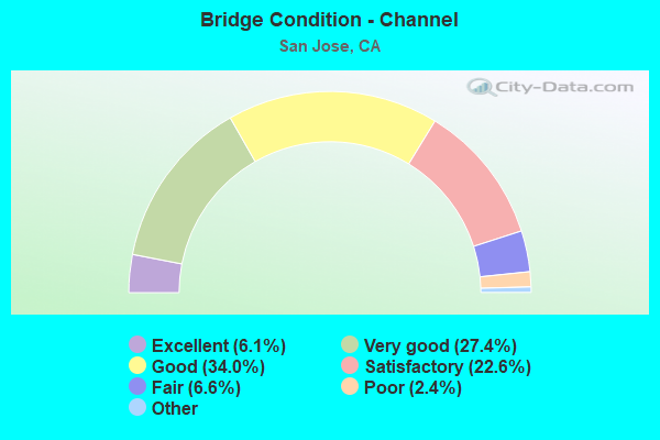
- Bridge Condition - Channel
- 6.1%Excellent
- 27.4%Very good
- 34.0%Good
- 22.6%Satisfactory
- 6.6%Fair
- 2.4%Poor
- 0.9%Serious
- 0.5%Critical
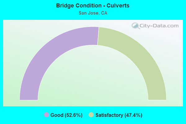
- Bridge Condition - Culverts
- 52.6%Good
- 47.4%Satisfactory
Find on map >> Show street view
Structure Number: 37 0287L, Location: 04-SCL-680-M1.19-SJS (Lat: 37.352225, Lng: -121.837931), Route carried "under" structure: City street C386, Year Built: 1974, Structure Length: 0. m, Average Daily Traffic: 1,500 (year 2009), Truck Traffic: 2%, Features Intersected: JACKSON AVE, Facility Carried by Structure: INTERSTATE 680 SB
Minimum Vertical Clearance: 4.57m (14.99ft), Kilometerpoint: 0.000, Lanes on structure: 5, Lanes under structure: 5, Material/Design: Prestressed concrete continuous, Design/Construction: Box Beam or Girders - Multiple, Length of Maximum Span: 41.8m (137.1ft)
Find on map >> Show street view
Structure Number: 37 0287R, Location: 04-SCL-680-M1.19-SJS (Lat: 37.351864, Lng: -121.837594), Route carried "under" structure: City street C386, Year Built: 1974, Structure Length: 0. m, Average Daily Traffic: 1,050 (year 2009), Truck Traffic: 2%, Features Intersected: JACKSON AVE, Facility Carried by Structure: INTERSTATE 680 NB
Minimum Vertical Clearance: 5.10m (16.73ft), Kilometerpoint: 0.000, Lanes on structure: 5, Lanes under structure: 5, Material/Design: Prestressed concrete continuous, Design/Construction: Box Beam or Girders - Multiple, Length of Maximum Span: 41.8m (137.1ft)
Find on map >> Show street view
Structure Number: 37 0288G, Location: 04-SCL-680-M1.41-SJS (Lat: 37.355353, Lng: -121.838047), Route carried "under" structure: Ramp Interstate 680, Year Built: 1974, Structure Length: 0. m, Average Daily Traffic: 10,800 (year 2009), Truck Traffic: 2%, Features Intersected: CAPITOL EXP,CAPITOL-N680
Minimum Vertical Clearance: 4.92m (16.14ft), Kilometerpoint: 1.410, Lanes on structure: 1, Lanes under structure: 6, Material/Design: Prestressed concrete continuous, Design/Construction: Box Beam or Girders - Multiple, Length of Maximum Span: 29.3m (96.1ft)
Find on map >> Show street view
Structure Number: 37 0288G, Location: 04-SCL-680-M1.41-SJS (Lat: 37.355353, Lng: -121.838047), Route carried "under" structure: City street , Year Built: 1974, Structure Length: 0. m, Average Daily Traffic: 5,000 (year 1998), Truck Traffic: 2%, Features Intersected: CAPITOL EXP,CAPITOL-N680, Facility Carried by Structure: N680-E&W130
Minimum Vertical Clearance: 5.86m (19.23ft), Kilometerpoint: 0.000, Lanes on structure: 1, Lanes under structure: 5, Material/Design: Prestressed concrete continuous, Design/Construction: Box Beam or Girders - Multiple, Length of Maximum Span: 29.3m (96.1ft)
Find on map >> Show street view
Structure Number: 37 0288K, Location: 04-SCL-680-M1.41-SJS (Lat: 37.355372, Lng: -121.838894), Route carried "under" structure: City street , Year Built: 1974, Structure Length: 0. m, Average Daily Traffic: 1,500 (year 2009), Truck Traffic: 2%, Features Intersected: CAPITOL EXPRESSWAY, Facility Carried by Structure: I-680 ON/OFF-RAMP
Minimum Vertical Clearance: 4.47m (14.67ft), Kilometerpoint: 0.000, Lanes on structure: 2, Lanes under structure: 5, Material/Design: Prestressed concrete continuous, Design/Construction: Box Beam or Girders - Multiple, Length of Maximum Span: 30.5m (100.1ft)
Find on map >> Show street view
Structure Number: 37 0288L, Location: 04-SCL-680-M1.41-SJS (Lat: 37.355358, Lng: -121.838511), Route carried "under" structure: City street , Year Built: 1974, Structure Length: 0. m, Average Daily Traffic: 5,000 (year 2009), Truck Traffic: 2%, Features Intersected: CAPITOL EXPRESSWAY, Facility Carried by Structure: INTERSTATE 680 SB
Minimum Vertical Clearance: 4.74m (15.55ft), Kilometerpoint: 0.000, Lanes on structure: 5, Lanes under structure: 5, Material/Design: Prestressed concrete continuous, Design/Construction: Box Beam or Girders - Multiple, Length of Maximum Span: 30.2m (99.1ft)
Find on map >> Show street view
Structure Number: 37 0288R, Location: 04-SCL-680-M1.41-SJS (Lat: 37.355358, Lng: -121.838222), Route carried "under" structure: City street , Year Built: 1974, Structure Length: 0. m, Average Daily Traffic: 1,600 (year 2009), Truck Traffic: 2%, Features Intersected: CAPITOL EXPRESSWAY, Facility Carried by Structure: INTERSTATE 680 NB
Minimum Vertical Clearance: 5.25m (17.22ft), Kilometerpoint: 0.000, Lanes on structure: 4, Lanes under structure: 5, Material/Design: Prestressed concrete continuous, Design/Construction: Box Beam or Girders - Multiple, Length of Maximum Span: 30.2m (99.1ft)
Find on map >> Show street view
Structure Number: 37 0289F, Location: 04-SCL-680-M1.55-SJS (Lat: 37.357186, Lng: -121.840044), Route carried "under" structure: Ramp Interstate 680, Year Built: 1974, Structure Length: 0. m, Average Daily Traffic: 10,100 (year 2003), Truck Traffic: 2%, Features Intersected: S680-CAPITOL XPWY RAMP, Facility Carried by Structure: ALUM ROCK AVE RAMP
Minimum Vertical Clearance: 4.82m (15.81ft), Kilometerpoint: 1.560, Lanes on structure: 1, Lanes under structure: 1, Material/Design: Prestressed concrete continuous, Design/Construction: Box Beam or Girders - Multiple, Length of Maximum Span: 43.3m (142.1ft)
Find on map >> Show street view
Structure Number: 37 029, Location: 04-SCL-680-M1.74-SJS (Lat: 37.359319, Lng: -121.841489), Route carried "under" structure: Ramp State highway 130, Year Built: 1974, Structure Length: 0. m, Average Daily Traffic: 14,400 (year 2003), Truck Traffic: 5%, Features Intersected: INTERSTATE 680, Facility Carried by Structure: ALUM ROCK AVE
Minimum Vertical Clearance: 5.21m (17.09ft), Kilometerpoint: 1.330, Lanes on structure: 4, Lanes under structure: 1, Material/Design: Prestressed concrete continuous, Design/Construction: Box Beam or Girders - Multiple, Length of Maximum Span: 50.0m (164.0ft)
Find on map >> Show street view
Structure Number: 37 029, Location: 04-SCL-680-M1.74-SJS (Lat: 37.359319, Lng: -121.841489), Route carried "under" structure: Interstate 680, Year Built: 1974, Structure Length: 0. m, Average Daily Traffic: 160,000 (year 2009), Truck Traffic: 2%, Features Intersected: INTERSTATE 680, Facility Carried by Structure: ALUM ROCK AVE
Minimum Vertical Clearance: 5.20m (17.06ft), Kilometerpoint: 1.740, Lanes on structure: 4, Lanes under structure: 10, Material/Design: Prestressed concrete continuous, Design/Construction: Box Beam or Girders - Multiple, Length of Maximum Span: 50.0m (164.0ft)
Find on map >> Show street view
Structure Number: 37 0291, Location: 04-SCL-680-M2.00-SJS (Lat: 37.362853, Lng: -121.843503), Route carried "under" structure: Interstate 680, Year Built: 1974, Structure Length: 0. m, Average Daily Traffic: 160,000 (year 2009), Truck Traffic: 2%, Features Intersected: INTERSTATE 680, Facility Carried by Structure: MADDEN AVE POC
Minimum Vertical Clearance: 6.57m (21.56ft), Kilometerpoint: 2.000, Lanes under structure: 10, Material/Design: Prestressed concrete continuous, Design/Construction: Box Beam or Girders - Multiple, Length of Maximum Span: 39.0m (128.0ft)
Find on map >> Show street view
Structure Number: 37 0292, Location: 04-SCL-680-M2.38-SJS (Lat: 37.367514, Lng: -121.846500), Route carried "under" structure: Interstate 680, Year Built: 1974, Structure Length: 0. m, Average Daily Traffic: 175,000 (year 2009), Truck Traffic: 5%, Features Intersected: INTERSTATE 680, Facility Carried by Structure: MCKEE ROAD
Minimum Vertical Clearance: 5.20m (17.06ft), Kilometerpoint: 2.380, Lanes on structure: 7, Lanes under structure: 10, Material/Design: Prestressed concrete continuous, Design/Construction: Box Beam or Girders - Multiple, Length of Maximum Span: 48.8m (160.1ft)
Find on map >> Show street view
Structure Number: 37 0293, Location: 04-SCL-680-M3.14-SJS (Lat: 37.376467, Lng: -121.855131), Route carried "under" structure: Interstate 680, Year Built: 1974, Structure Length: 0. m, Average Daily Traffic: 175,000 (year 2009), Truck Traffic: 5%, Features Intersected: INTERSTATE 680, Facility Carried by Structure: MABURY ROAD
Minimum Vertical Clearance: 5.15m (16.90ft), Kilometerpoint: 3.140, Lanes on structure: 2, Lanes under structure: 8, Material/Design: Concrete continuous, Design/Construction: Box Beam or Girders - Multiple, Length of Maximum Span: 30.8m (101.0ft)
Find on map >> Show street view
Structure Number: 37 0296, Location: 04-SCL-680-M4.78-SJS (Lat: 37.395136, Lng: -121.873586), Route carried "under" structure: County highway C021, Year Built: 1974, Structure Length: 0. m, Average Daily Traffic: 90,000 (year 2009), Truck Traffic: 5%, Features Intersected: HOSTETTER ROAD, Facility Carried by Structure: INTERSTATE 680
Minimum Vertical Clearance: 5.10m (16.73ft), Kilometerpoint: 0.000, Lanes on structure: 9, Lanes under structure: 6, Material/Design: Prestressed concrete, Design/Construction: Box Beam or Girders - Multiple, Length of Maximum Span: 50.0m (164.0ft)
Find on map >> Show street view
Structure Number: 37 0297, Location: 04-SCL-680-M5.07-SJS (Lat: 37.398547, Lng: -121.875078), Route carried "under" structure: County highway , Year Built: 1974, Structure Length: 0. m, Average Daily Traffic: 1,500 (year 2009), Truck Traffic: 2%, Features Intersected: CAPITOL AVENUE, Facility Carried by Structure: INTERSTATE 680
Minimum Vertical Clearance: 4.88m (16.01ft), Kilometerpoint: 0.000, Lanes on structure: 10, Lanes under structure: 5, Material/Design: Prestressed concrete continuous, Design/Construction: Box Beam or Girders - Multiple, Length of Maximum Span: 41.1m (134.8ft)
Find on map >> Show street view
Structure Number: 37 0298, Location: 04-SCL-680-M5.54-SJS (Lat: 37.405256, Lng: -121.877931), Route carried "under" structure: Interstate 680, Year Built: 1974, Structure Length: 0. m, Average Daily Traffic: 175,000 (year 2009), Truck Traffic: 5%, Features Intersected: INTERSTATE 680, Facility Carried by Structure: CROPLEY AVENUE
Minimum Vertical Clearance: 5.13m (16.83ft), Kilometerpoint: 5.540, Lanes on structure: 4, Lanes under structure: 8, Material/Design: Concrete continuous, Design/Construction: Box Beam or Girders - Multiple, Length of Maximum Span: 32.0m (105.0ft)
Find on map >> Show street view
Structure Number: 37 0307, Location: 04-SCL-017-13.11-CMB (Lat: 37.305119, Lng: -121.941175), Route carried "under" structure: State highway 17, Year Built: 1966, Structure Length: 0. m, Average Daily Traffic: 184,800 (year 2017), Truck Traffic: 4%, Features Intersected: STATE ROUTE 17, Facility Carried by Structure: PEDESTRIAN WALKWAY
Minimum Vertical Clearance: 5.59m (18.34ft), Kilometerpoint: 13.110, Lanes under structure: 9, Material/Design: Prestressed concrete, Design/Construction: Box Beam or Girders - Multiple, Length of Maximum Span: 26.2m (86.0ft)
Find on map >> Show street view
Structure Number: 37 0308, Location: 04-SCL-087-5.67-SJS (Lat: 37.330517, Lng: -121.896075), Route carried "under" structure: City street C030, Year Built: 1978, Structure Length: 0. m, Average Daily Traffic: 8,270 (year 1998), Truck Traffic: 3%, Features Intersected: GUADALUPE RIVER & ROADS, Facility Carried by Structure: STATE ROUTE 87
Minimum Vertical Clearance: 5.20m (17.06ft), Kilometerpoint: 0.000, Lanes on structure: 8, Lanes under structure: 2, Material/Design: Prestressed concrete continuous, Design/Construction: Box Beam or Girders - Multiple, Length of Maximum Span: 47.5m (155.8ft)
Find on map >> Show street view
Structure Number: 37 0308, Location: 04-SCL-087-5.67-SJS (Lat: 37.330517, Lng: -121.896075), Route carried "under" structure: City street C277, Year Built: 1978, Structure Length: 0. m, Average Daily Traffic: 24,635 (year 1998), Truck Traffic: 5%, Features Intersected: GUADALUPE RIVER & ROADS, Facility Carried by Structure: STATE ROUTE 87
Minimum Vertical Clearance: 5.13m (16.83ft), Kilometerpoint: 0.000, Lanes on structure: 8, Lanes under structure: 4, Material/Design: Prestressed concrete continuous, Design/Construction: Box Beam or Girders - Multiple, Length of Maximum Span: 47.5m (155.8ft)
Find on map >> Show street view
Structure Number: 37 031, Location: 04-SCL-087-5.56-SJS (Lat: 37.329100, Lng: -121.895458), Route carried "under" structure: City street C260, Year Built: 1978, Structure Length: 0. m, Average Daily Traffic: 10,900 (year 1998), Truck Traffic: 5%, Features Intersected: PARK AVENUE, Facility Carried by Structure: STATE ROUTE 87
Minimum Vertical Clearance: 5.96m (19.55ft), Kilometerpoint: 0.000, Lanes on structure: 7, Lanes under structure: 4, Material/Design: Concrete continuous, Design/Construction: Box Beam or Girders - Multiple, Length of Maximum Span: 29.0m (95.1ft)
Find on map >> Show street view
Structure Number: 37 0311, Location: 04-SCL-087-6.27-SJS (Lat: 37.339128, Lng: -121.898419), Route carried "under" structure: City street , Year Built: 1988, Structure Length: 0. m, Average Daily Traffic: 1,150 (year 2000), Truck Traffic: 2%, Features Intersected: UP RR, AMTRAK, STREETS, Facility Carried by Structure: STATE ROUTE 87
Minimum Vertical Clearance: 7.77m (25.49ft), Kilometerpoint: 0.000, Lanes on structure: 8, Lanes under structure: 2, Material/Design: Prestressed concrete continuous, Design/Construction: Box Beam or Girders - Multiple, Length of Maximum Span: 40.0m (131.2ft)
Find on map >> Show street view
Structure Number: 37 0311, Location: 04-SCL-087-6.27-SJS (Lat: 37.339128, Lng: -121.898419), Route carried "under" structure: City street , Year Built: 1988, Structure Length: 0. m, Average Daily Traffic: 13,440 (year 1999), Truck Traffic: 10%, Features Intersected: UP RR, AMTRAK, STREETS, Facility Carried by Structure: STATE ROUTE 87
Minimum Vertical Clearance: 6.60m (21.65ft), Kilometerpoint: 0.000, Lanes on structure: 8, Lanes under structure: 6, Material/Design: Prestressed concrete continuous, Design/Construction: Box Beam or Girders - Multiple, Length of Maximum Span: 40.0m (131.2ft)
Find on map >> Show street view
Structure Number: 37 0311, Location: 04-SCL-087-6.27-SJS (Lat: 37.339128, Lng: -121.898419), Route carried "under" structure: City street , Year Built: 1988, Structure Length: 0. m, Average Daily Traffic: 1,000 (year 1998), Truck Traffic: 5%, Features Intersected: UP RR, AMTRAK, STREETS, Facility Carried by Structure: STATE ROUTE 87
Minimum Vertical Clearance: 9.01m (29.56ft), Kilometerpoint: 0.000, Lanes on structure: 8, Lanes under structure: 2, Material/Design: Prestressed concrete continuous, Design/Construction: Box Beam or Girders - Multiple, Length of Maximum Span: 40.0m (131.2ft)
Find on map >> Show street view
Structure Number: 37 0312, Location: 04-SCL-087-5.99-SJS (Lat: 37.335069, Lng: -121.897111), Route carried "under" structure: City street , Year Built: 1988, Structure Length: 0. m, Average Daily Traffic: 1,670 (year 2000), Truck Traffic: 3%, Features Intersected: N ALMADEN BOULEVARD, Facility Carried by Structure: STATE ROUTE 87
Minimum Vertical Clearance: 5.15m (16.90ft), Kilometerpoint: 0.000, Lanes on structure: 8, Lanes under structure: 2, Material/Design: Prestressed concrete, Design/Construction: Box Beam or Girders - Multiple, Length of Maximum Span: 42.3m (138.8ft)
Find on map >> Show street view
Structure Number: 37 0312G, Location: 04-SCL-087-6.00-SJS (Lat: 37.335069, Lng: -121.896869), Route carried "under" structure: City street , Year Built: 1988, Structure Length: 0. m, Average Daily Traffic: 1,670 (year 2000), Truck Traffic: 3%, Features Intersected: N ALMADEN BOULEVARD, Facility Carried by Structure: OFF-RAMP/I280-N87
Minimum Vertical Clearance: 6.07m (19.91ft), Kilometerpoint: 0.000, Lanes on structure: 3, Lanes under structure: 2, Material/Design: Prestressed concrete, Design/Construction: Box Beam or Girders - Multiple, Length of Maximum Span: 45.3m (148.6ft)
Find on map >> Show street view
Structure Number: 37 0315, Location: 04-SCL-087-4.86-SJS (Lat: 37.319847, Lng: -121.890581), Route carried "under" structure: State highway 87, Year Built: 1972, Structure Length: 0. m, Average Daily Traffic: 130,000 (year 2009), Truck Traffic: 3%, Features Intersected: STATE ROUTE 87, Facility Carried by Structure: VIRGINIA STREET
Minimum Vertical Clearance: 4.54m (14.90ft), Kilometerpoint: 4.860, Lanes on structure: 2, Lanes under structure: 11, Material/Design: Prestressed concrete continuous, Design/Construction: Box Beam or Girders - Multiple, Length of Maximum Span: 41.9m (137.5ft)
Find on map >> Show street view
Structure Number: 37 0319, Location: 04-SCL-087-6.10-SJS (Lat: 37.336781, Lng: -121.897303), Route carried "under" structure: Business City street , Year Built: 1988, Structure Length: 0. m, Average Daily Traffic: 22,500 (year 1998), Truck Traffic: 3%, Features Intersected: JULIAN STREET, Facility Carried by Structure: STATE ROUTE 87
Minimum Vertical Clearance: 5.20m (17.06ft), Kilometerpoint: 0.000, Lanes on structure: 8, Lanes under structure: 9, Material/Design: Prestressed concrete continuous, Design/Construction: Box Beam or Girders - Multiple, Length of Maximum Span: 35.7m (117.1ft)
Find on map >> Show street view
Structure Number: 37 0322, Location: 04-SCL-280-R4.24-SJS (Lat: 37.316331, Lng: -121.919417), Route carried "under" structure: City street , Year Built: 1972, Structure Length: 0. m, Average Daily Traffic: 5,500 (year 1997), Truck Traffic: 4%, Features Intersected: INTERSTATE 280, Facility Carried by Structure: PEDESTRIAN WALKWAY
Minimum Vertical Clearance: 5.28m (17.32ft), Kilometerpoint: 0.000, Lanes under structure: 3, Material/Design: Prestressed concrete continuous, Design/Construction: Box Beam or Girders - Multiple, Length of Maximum Span: 69.8m (229.0ft)
Find on map >> Show street view
Structure Number: 37 0322, Location: 04-SCL-280-R4.24-SJS (Lat: 37.316331, Lng: -121.919417), Route carried "under" structure: Interstate 280, Year Built: 1972, Structure Length: 0. m, Average Daily Traffic: 196,000 (year 2009), Truck Traffic: 1%, Features Intersected: INTERSTATE 280, Facility Carried by Structure: PEDESTRIAN WALKWAY
Minimum Vertical Clearance: 9.02m (29.59ft), Kilometerpoint: 4.240, Lanes under structure: 12, Material/Design: Prestressed concrete continuous, Design/Construction: Box Beam or Girders - Multiple, Length of Maximum Span: 69.8m (229.0ft)
Find on map >> Show street view
Structure Number: 37 0339, Location: 04-SCL-101-R25.31 (Lat: 37.229333, Lng: -121.747600), Route carried "under" structure: US 101, Year Built: 1982, Structure Length: 0. m, Average Daily Traffic: 100,000 (year 2009), Truck Traffic: 9%, Features Intersected: US HIGHWAY 101, Facility Carried by Structure: METCALF ROAD
Minimum Vertical Clearance: 5.00m (16.40ft), Kilometerpoint: 25.310, Lanes on structure: 2, Lanes under structure: 8, Material/Design: Prestressed concrete continuous, Design/Construction: Box Beam or Girders - Multiple, Length of Maximum Span: 36.6m (120.1ft)
Find on map >> Show street view
Structure Number: 37 034, Location: 04-SCL-680-M5.83-SJS (Lat: 37.409714, Lng: -121.879703), Route carried "under" structure: Interstate 680, Year Built: 1974, Structure Length: 0. m, Average Daily Traffic: 175,000 (year 2009), Truck Traffic: 5%, Features Intersected: INTERSTATE 680, Facility Carried by Structure: PEDESTRIAN WALKWAY
Minimum Vertical Clearance: 6.20m (20.34ft), Kilometerpoint: 5.830, Lanes under structure: 10, Material/Design: Prestressed concrete continuous, Design/Construction: Box Beam or Girders - Single/Spread, Length of Maximum Span: 34.5m (113.2ft)
Find on map >> Show street view
Structure Number: 37 0342, Location: 04-SCL-101-R18.70 (Lat: 37.162225, Lng: -121.663392), Route carried "under" structure: US 101, Year Built: 1980, Structure Length: 0. m, Average Daily Traffic: 125,000 (year 2009), Truck Traffic: 8%, Features Intersected: U.S. HIGHWAY 101, Facility Carried by Structure: BURNETT AVENUE
Minimum Vertical Clearance: 5.41m (17.75ft), Kilometerpoint: 18.700, Lanes on structure: 2, Lanes under structure: 8, Material/Design: Prestressed concrete continuous, Design/Construction: Box Beam or Girders - Multiple, Length of Maximum Span: 34.4m (112.9ft)
Find on map >> Show street view
Structure Number: 37 0344L, Location: 04-SCL-101-R21.25-SJS (Lat: 37.190528, Lng: -121.693094), Route carried "under" structure: City street C133, Year Built: 1980, Structure Length: 0. m, Average Daily Traffic: 400 (year 1998), Truck Traffic: 5%, Features Intersected: COYOTE CREEK ROAD, Facility Carried by Structure: SB US HIGHWAY 101
Minimum Vertical Clearance: 5.43m (17.81ft), Kilometerpoint: 0.000, Lanes on structure: 4, Lanes under structure: 2, Material/Design: Prestressed concrete continuous, Design/Construction: Box Beam or Girders - Multiple, Length of Maximum Span: 25.7m (84.3ft)
Find on map >> Show street view
Structure Number: 37 0344R, Location: 04-SCL-101-R21.25-SJS (Lat: 37.190700, Lng: -121.692764), Route carried "under" structure: City street C133, Year Built: 1980, Structure Length: 0. m, Average Daily Traffic: 400 (year 1998), Truck Traffic: 5%, Features Intersected: COYOTE CREEK ROAD, Facility Carried by Structure: NB US HIGHWAY 101
Minimum Vertical Clearance: 7.06m (23.16ft), Kilometerpoint: 0.000, Lanes on structure: 4, Lanes under structure: 2, Material/Design: Prestressed concrete continuous, Design/Construction: Box Beam or Girders - Multiple, Length of Maximum Span: 29.9m (98.1ft)
Find on map >> Show street view
Structure Number: 37 0347L, Location: 04-SCL-101-R27.00-SJS (Lat: 37.243839, Lng: -121.772442), Route carried "under" structure: City street C058, Year Built: 1982, Structure Length: 0. m, Average Daily Traffic: 11,800 (year 1998), Truck Traffic: 5%, Features Intersected: BERNAL ROAD, Facility Carried by Structure: SB US HIGHWAY 101
Minimum Vertical Clearance: 5.28m (17.32ft), Kilometerpoint: 0.000, Lanes on structure: 4, Lanes under structure: 6, Material/Design: Prestressed concrete continuous, Design/Construction: Box Beam or Girders - Multiple, Length of Maximum Span: 32.4m (106.3ft)
Find on map >> Show street view
Structure Number: 37 0347R, Location: 04-SCL-101-R27.01-SJS (Lat: 37.244275, Lng: -121.772467), Route carried "under" structure: City street C058, Year Built: 1982, Structure Length: 0. m, Average Daily Traffic: 11,800 (year 1998), Truck Traffic: 5%, Features Intersected: BERNAL ROAD, Facility Carried by Structure: NB US HIGHWAY 101
Minimum Vertical Clearance: 4.97m (16.31ft), Kilometerpoint: 0.000, Lanes on structure: 5, Lanes under structure: 6, Material/Design: Prestressed concrete continuous, Design/Construction: Box Beam or Girders - Multiple, Length of Maximum Span: 32.5m (106.6ft)
Find on map >> Show street view
Structure Number: 37 0348L, Location: 04-SCL-101-R28.11-SJS (Lat: 37.257089, Lng: -121.796733), Route carried "under" structure: US 101, Year Built: 1982, Structure Length: 0. m, Average Daily Traffic: 100,000 (year 2009), Truck Traffic: 9%, Features Intersected: US HIGHWAY 101, Facility Carried by Structure: EB SLVR CRK VLY RD
Minimum Vertical Clearance: 5.08m (16.67ft), Kilometerpoint: 28.110, Lanes on structure: 2, Lanes under structure: 9, Material/Design: Prestressed concrete continuous, Design/Construction: Box Beam or Girders - Multiple, Length of Maximum Span: 54.9m (180.1ft)
Find on map >> Show street view
Structure Number: 37 0348R, Location: 04-SCL-101-R28.11-SJS (Lat: 37.257283, Lng: -121.796969), Route carried "under" structure: US 101, Year Built: 1982, Structure Length: 0. m, Average Daily Traffic: 100,000 (year 2009), Truck Traffic: 9%, Features Intersected: US HIGHWAY 101, Facility Carried by Structure: WB SLVR CRK VLY RD
Minimum Vertical Clearance: 5.68m (18.64ft), Kilometerpoint: 28.110, Lanes on structure: 2, Lanes under structure: 9, Material/Design: Prestressed concrete continuous, Design/Construction: Box Beam or Girders - Multiple, Length of Maximum Span: 54.9m (180.1ft)
Find on map >> Show street view
Structure Number: 37 0351, Location: 04-SCL-680-M0.78-SJS (Lat: 37.347572, Lng: -121.841911), Route carried "under" structure: Interstate 680, Year Built: 1974, Structure Length: 0. m, Average Daily Traffic: 160,000 (year 2009), Truck Traffic: 2%, Features Intersected: INTERSTATE 680, Facility Carried by Structure: SUNSET POC
Minimum Vertical Clearance: 5.69m (18.67ft), Kilometerpoint: 0.780, Lanes under structure: 12, Material/Design: Prestressed concrete continuous, Design/Construction: Box Beam or Girders - Single/Spread, Length of Maximum Span: 37.2m (122.0ft)
Find on map >> Show street view
Structure Number: 37 0352H, Location: 04-SCL-101-34.87-SJS (Lat: 37.338058, Lng: -121.849100), Route carried "under" structure: City street C020, Year Built: 1974, Structure Length: 0. m, Average Daily Traffic: 10,000 (year 1998), Truck Traffic: 6%, Features Intersected: I 280,I 680,US 101,STORY, Facility Carried by Structure: N&S101- N280&N680
Minimum Vertical Clearance: 5.59m (18.34ft), Kilometerpoint: 0.000, Lanes on structure: 2, Lanes under structure: 6, Material/Design: Concrete continuous, Design/Construction: Box Beam or Girders - Multiple, Length of Maximum Span: 47.9m (157.2ft)
Find on map >> Show street view
Structure Number: 37 0352H, Location: 04-SCL-101-34.87-SJS (Lat: 37.338058, Lng: -121.849100), Route carried "under" structure: US 101, Year Built: 1974, Structure Length: 0. m, Average Daily Traffic: 200,000 (year 1998), Truck Traffic: 5%, Features Intersected: I 280,I 680,US 101,STORY
Minimum Vertical Clearance: 12.19m (39.99ft), Kilometerpoint: 34.870, Lanes on structure: 2, Lanes under structure: 3, Material/Design: Concrete continuous, Design/Construction: Box Beam or Girders - Multiple, Length of Maximum Span: 47.9m (157.2ft)
Find on map >> Show street view
Structure Number: 37 0352H, Location: 04-SCL-101-34.87-SJS (Lat: 37.338058, Lng: -121.849100), Route carried "under" structure: Ramp US 101, Year Built: 1974, Structure Length: 0. m, Average Daily Traffic: 10,000 (year 1998), Truck Traffic: 5%, Features Intersected: I 280,I 680,US 101,STORY
Minimum Vertical Clearance: 12.19m (39.99ft), Kilometerpoint: 34.870, Lanes on structure: 2, Lanes under structure: 1, Material/Design: Concrete continuous, Design/Construction: Box Beam or Girders - Multiple, Length of Maximum Span: 47.9m (157.2ft)
Find on map >> Show street view
Structure Number: 37 0352H, Location: 04-SCL-101-34.87-SJS (Lat: 37.338058, Lng: -121.849100), Route carried "under" structure: Ramp US 101, Year Built: 1974, Structure Length: 0. m, Average Daily Traffic: 10,000 (year 1998), Truck Traffic: 5%, Features Intersected: I 280,I 680,US 101,STORY
Minimum Vertical Clearance: 9.14m (29.99ft), Kilometerpoint: 34.870, Lanes on structure: 2, Lanes under structure: 1, Material/Design: Concrete continuous, Design/Construction: Box Beam or Girders - Multiple, Length of Maximum Span: 47.9m (157.2ft)
Find on map >> Show street view
Structure Number: 37 0352H, Location: 04-SCL-101-34.87-SJS (Lat: 37.338058, Lng: -121.849100), Route carried "under" structure: Ramp Interstate 680, Year Built: 1974, Structure Length: 0. m, Average Daily Traffic: 10,000 (year 1998), Truck Traffic: 5%, Features Intersected: I 280,I 680,US 101,STORY
Minimum Vertical Clearance: 5.97m (19.59ft), Kilometerpoint: 0.020, Lanes on structure: 2, Lanes under structure: 1, Material/Design: Concrete continuous, Design/Construction: Box Beam or Girders - Multiple, Length of Maximum Span: 47.9m (157.2ft)
Find on map >> Show street view
Structure Number: 37 0352H, Location: 04-SCL-101-34.87-SJS (Lat: 37.338058, Lng: -121.849100), Route carried "under" structure: Interstate 680, Year Built: 1974, Structure Length: 0. m, Average Daily Traffic: 197,000 (year 1998), Truck Traffic: 5%, Features Intersected: I 280,I 680,US 101,STORY
Minimum Vertical Clearance: 5.15m (16.90ft), Kilometerpoint: 0.020, Lanes on structure: 2, Lanes under structure: 8, Material/Design: Concrete continuous, Design/Construction: Box Beam or Girders - Multiple, Length of Maximum Span: 47.9m (157.2ft)
Find on map >> Show street view
Structure Number: 37 0352H, Location: 04-SCL-101-34.87-SJS (Lat: 37.338058, Lng: -121.849100), Route carried "under" structure: Ramp Interstate 280, Year Built: 1974, Structure Length: 0. m, Average Daily Traffic: 100,000 (year 1998), Truck Traffic: 5%, Features Intersected: I 280,I 680,US 101,STORY
Minimum Vertical Clearance: 5.20m (17.06ft), Kilometerpoint: 0.020, Lanes on structure: 2, Lanes under structure: 1, Material/Design: Concrete continuous, Design/Construction: Box Beam or Girders - Multiple, Length of Maximum Span: 47.9m (157.2ft)
Find on map >> Show street view
Structure Number: 37 0352H, Location: 04-SCL-101-34.87-SJS (Lat: 37.338058, Lng: -121.849100), Route carried "under" structure: Ramp US 101, Year Built: 1974, Structure Length: 0. m, Average Daily Traffic: 10,000 (year 1998), Truck Traffic: 3%, Features Intersected: I 280,I 680,US 101,STORY
Minimum Vertical Clearance: 8.23m (27.00ft), Kilometerpoint: 34.870, Lanes on structure: 2, Lanes under structure: 1, Material/Design: Concrete continuous, Design/Construction: Box Beam or Girders - Multiple, Length of Maximum Span: 47.9m (157.2ft)
Find on map >> Show street view
Structure Number: 37 0353F, Location: 04-SCL-680-M0.01-SJS (Lat: 37.337361, Lng: -121.851097), Route carried "under" structure: City street C020, Year Built: 1982, Structure Length: 0. m, Average Daily Traffic: 7,000 (year 1998), Truck Traffic: 3%, Features Intersected: I 280,I 680,US 101,STORY, Facility Carried by Structure: S680-S101 CONNECTR
Minimum Vertical Clearance: 6.15m (20.18ft), Kilometerpoint: 0.000, Lanes on structure: 2, Lanes under structure: 6, Material/Design: Concrete continuous, Design/Construction: Box Beam or Girders - Multiple, Length of Maximum Span: 51.5m (169.0ft)
Find on map >> Show street view
Structure Number: 37 0353F, Location: 04-SCL-680-M0.01-SJS (Lat: 37.337361, Lng: -121.851097), Route carried "under" structure: Ramp US 101, Year Built: 1982, Structure Length: 0. m, Average Daily Traffic: 6,500 (year 1998), Truck Traffic: 3%, Features Intersected: I 280,I 680,US 101,STORY
Minimum Vertical Clearance: 7.21m (23.65ft), Kilometerpoint: 34.870, Lanes on structure: 2, Lanes under structure: 1, Material/Design: Concrete continuous, Design/Construction: Box Beam or Girders - Multiple, Length of Maximum Span: 51.5m (169.0ft)
Find on map >> Show street view
Structure Number: 37 0353F, Location: 04-SCL-680-M0.01-SJS (Lat: 37.337361, Lng: -121.851097), Route carried "under" structure: Ramp US 101, Year Built: 1982, Structure Length: 0. m, Average Daily Traffic: 12,000 (year 1998), Truck Traffic: 3%, Features Intersected: I 280,I 680,US 101,STORY
Minimum Vertical Clearance: 9.14m (29.99ft), Kilometerpoint: 34.870, Lanes on structure: 2, Lanes under structure: 1, Material/Design: Concrete continuous, Design/Construction: Box Beam or Girders - Multiple, Length of Maximum Span: 51.5m (169.0ft)
Find on map >> Show street view
Structure Number: 37 0353F, Location: 04-SCL-680-M0.01-SJS (Lat: 37.337361, Lng: -121.851097), Route carried "under" structure: Ramp US 101, Year Built: 1982, Structure Length: 0. m, Average Daily Traffic: 14,000 (year 1998), Truck Traffic: 3%, Features Intersected: I 280,I 680,US 101,STORY
Minimum Vertical Clearance: 15.24m (50.00ft), Kilometerpoint: 34.870, Lanes on structure: 2, Lanes under structure: 1, Material/Design: Concrete continuous, Design/Construction: Box Beam or Girders - Multiple, Length of Maximum Span: 51.5m (169.0ft)
Find on map >> Show street view
Structure Number: 37 0353F, Location: 04-SCL-680-M0.01-SJS (Lat: 37.337361, Lng: -121.851097), Route carried "under" structure: Ramp US 101, Year Built: 1982, Structure Length: 0. m, Average Daily Traffic: 1,400 (year 2009), Truck Traffic: 3%, Features Intersected: I 280,I 680,US 101,STORY
Minimum Vertical Clearance: 15.24m (50.00ft), Kilometerpoint: 34.870, Lanes on structure: 2, Lanes under structure: 1, Material/Design: Concrete continuous, Design/Construction: Box Beam or Girders - Multiple, Length of Maximum Span: 51.5m (169.0ft)
Find on map >> Show street view
Structure Number: 37 0353F, Location: 04-SCL-680-M0.01-SJS (Lat: 37.337361, Lng: -121.851097), Route carried "under" structure: Ramp US 101, Year Built: 1982, Structure Length: 0. m, Average Daily Traffic: 18,000 (year 2009), Truck Traffic: 3%, Features Intersected: I 280,I 680,US 101,STORY
Minimum Vertical Clearance: 5.64m (18.50ft), Kilometerpoint: 34.870, Lanes on structure: 2, Lanes under structure: 2, Material/Design: Concrete continuous, Design/Construction: Box Beam or Girders - Multiple, Length of Maximum Span: 51.5m (169.0ft)
Find on map >> Show street view
Structure Number: 37 0353F, Location: 04-SCL-680-M0.01-SJS (Lat: 37.337361, Lng: -121.851097), Route carried "under" structure: Ramp US 101, Year Built: 1982, Structure Length: 0. m, Average Daily Traffic: 25,000 (year 2009), Truck Traffic: 4%, Features Intersected: I 280,I 680,US 101,STORY
Minimum Vertical Clearance: 5.26m (17.26ft), Kilometerpoint: 34.870, Lanes on structure: 2, Lanes under structure: 2, Material/Design: Concrete continuous, Design/Construction: Box Beam or Girders - Multiple, Length of Maximum Span: 51.5m (169.0ft)
Find on map >> Show street view
Structure Number: 37 0353F, Location: 04-SCL-680-M0.01-SJS (Lat: 37.337361, Lng: -121.851097), Route carried "under" structure: Ramp Interstate 680, Year Built: 1982, Structure Length: 0. m, Average Daily Traffic: 22,200 (year 2009), Truck Traffic: 5%, Features Intersected: I 280,I 680,US 101,STORY
Minimum Vertical Clearance: 5.36m (17.59ft), Kilometerpoint: 0.020, Lanes on structure: 2, Lanes under structure: 2, Material/Design: Concrete continuous, Design/Construction: Box Beam or Girders - Multiple, Length of Maximum Span: 51.5m (169.0ft)
Find on map >> Show street view
Structure Number: 37 0353F, Location: 04-SCL-680-M0.01-SJS (Lat: 37.337361, Lng: -121.851097), Route carried "under" structure: Ramp Interstate 280, Year Built: 1982, Structure Length: 0. m, Average Daily Traffic: 58,000 (year 2009), Truck Traffic: 9%, Features Intersected: I 280,I 680,US 101,STORY, Facility Carried by Structure: S680-S101 CONNECTR
Minimum Vertical Clearance: 15.24m (50.00ft), Kilometerpoint: 0.020, Lanes on structure: 2, Lanes under structure: 1, Material/Design: Concrete continuous, Design/Construction: Box Beam or Girders - Multiple, Length of Maximum Span: 51.5m (169.0ft)
Find on map >> Show street view
Structure Number: 37 0361L, Location: 04-SCL-087-2.52-SJS (Lat: 37.289717, Lng: -121.871089), Route carried "under" structure: City street , Year Built: 1993, Structure Length: 0. m, Average Daily Traffic: 500 (year 1998), Truck Traffic: 19%, Features Intersected: CAROL DRIVE, Facility Carried by Structure: SB STATE ROUTE 87
Minimum Vertical Clearance: 6.95m (22.80ft), Kilometerpoint: 0.000, Lanes on structure: 3, Lanes under structure: 2, Material/Design: Prestressed concrete, Design/Construction: Box Beam or Girders - Multiple, Length of Maximum Span: 25.3m (83.0ft)
Find on map >> Show street view
Structure Number: 37 0361R, Location: 04-SCL-087-2.52-SJS (Lat: 37.289772, Lng: -121.870725), Route carried "under" structure: City street , Year Built: 1993, Structure Length: 0. m, Average Daily Traffic: 500 (year 1998), Truck Traffic: 1%, Features Intersected: CAROL DRIVE, Facility Carried by Structure: NB STATE ROUTE 87
Minimum Vertical Clearance: 4.95m (16.24ft), Kilometerpoint: 0.000, Lanes on structure: 3, Lanes under structure: 2, Material/Design: Prestressed concrete, Design/Construction: Box Beam or Girders - Multiple, Length of Maximum Span: 25.6m (84.0ft)
Find on map >> Show street view
Structure Number: 37 0362L, Location: 04-SCL-087-2.84-SJS (Lat: 37.294119, Lng: -121.872881), Route carried "under" structure: City street , Year Built: 1993, Structure Length: 0. m, Average Daily Traffic: 26,548 (year 1998), Truck Traffic: 5%, Features Intersected: CURTNER AVENUE, Facility Carried by Structure: SB STATE ROUTE 87
Minimum Vertical Clearance: 5.25m (17.22ft), Kilometerpoint: 0.000, Lanes on structure: 4, Lanes under structure: 6, Material/Design: Prestressed concrete continuous, Design/Construction: Box Beam or Girders - Multiple, Length of Maximum Span: 37.6m (123.4ft)
Find on map >> Show street view
Structure Number: 37 0362R, Location: 04-SCL-087-2.84-SJS (Lat: 37.294428, Lng: -121.872625), Route carried "under" structure: City street , Year Built: 1993, Structure Length: 0. m, Average Daily Traffic: 26,548 (year 1998), Truck Traffic: 5%, Features Intersected: CURTNER AVENUE, Facility Carried by Structure: NB STATE ROUTE 87
Minimum Vertical Clearance: 4.82m (15.81ft), Kilometerpoint: 0.000, Lanes on structure: 3, Lanes under structure: 6, Material/Design: Prestressed concrete continuous, Design/Construction: Box Beam or Girders - Multiple, Length of Maximum Span: 37.6m (123.4ft)
Find on map >> Show street view
Structure Number: 37 0366L, Location: 04-SCL-087-3.58-SJS (Lat: 37.303753, Lng: -121.878483), Route carried "under" structure: City street C265, Year Built: 1991, Structure Length: 0. m, Average Daily Traffic: 5,000 (year 1998), Truck Traffic: 2%, Features Intersected: ALMADEN ROAD, Facility Carried by Structure: SB STATE ROUTE 87
Minimum Vertical Clearance: 4.64m (15.22ft), Kilometerpoint: 0.000, Lanes on structure: 4, Lanes under structure: 2, Material/Design: Prestressed concrete continuous, Design/Construction: Box Beam or Girders - Multiple, Length of Maximum Span: 25.9m (85.0ft)
Find on map >> Show street view
Structure Number: 37 0366R, Location: 04-SCL-087-3.58-SJS (Lat: 37.304233, Lng: -121.878347), Route carried "under" structure: City street C265, Year Built: 1991, Structure Length: 0. m, Average Daily Traffic: 5,000 (year 1998), Truck Traffic: 2%, Features Intersected: ALMADEN ROAD, Facility Carried by Structure: NB STATE ROUTE 87
Minimum Vertical Clearance: 5.25m (17.22ft), Kilometerpoint: 0.000, Lanes on structure: 4, Lanes under structure: 2, Material/Design: Prestressed concrete continuous, Design/Construction: Box Beam or Girders - Multiple, Length of Maximum Span: 29.3m (96.1ft)
Find on map >> Show street view
Structure Number: 37 0368L, Location: 04-SCL-087-4.07-SJS (Lat: 37.309875, Lng: -121.883308), Route carried "under" structure: City street C259, Year Built: 1990, Structure Length: 0. m, Average Daily Traffic: 450 (year 1998), Truck Traffic: 1%, Features Intersected: ALMA AVENUE, Facility Carried by Structure: SB STATE ROUTE 87
Minimum Vertical Clearance: 4.90m (16.08ft), Kilometerpoint: 0.000, Lanes on structure: 4, Lanes under structure: 4, Material/Design: Prestressed concrete, Design/Construction: Box Beam or Girders - Multiple, Length of Maximum Span: 37.9m (124.3ft)
Find on map >> Show street view
Structure Number: 37 0368R, Location: 04-SCL-087-4.07-SJS (Lat: 37.310008, Lng: -121.882975), Route carried "under" structure: City street C259, Year Built: 1990, Structure Length: 0. m, Average Daily Traffic: 5,000 (year 1998), Truck Traffic: 2%, Features Intersected: ALMA AVENUE, Facility Carried by Structure: NB STATE ROUTE 87
Minimum Vertical Clearance: 5.99m (19.65ft), Kilometerpoint: 0.000, Lanes on structure: 3, Lanes under structure: 4, Material/Design: Prestressed concrete, Design/Construction: Box Beam or Girders - Multiple, Length of Maximum Span: 40.4m (132.5ft)
Find on map >> Show street view
Structure Number: 37 0371L, Location: 04-SCL-680-M3.84-SJS (Lat: 37.384194, Lng: -121.863289), Route carried "under" structure: Interstate 680, Year Built: 1974, Structure Length: 0. m, Average Daily Traffic: 175,000 (year 2009), Truck Traffic: 5%, Features Intersected: INTERSTATE 680, Facility Carried by Structure: BERRYESSA RD WB
Minimum Vertical Clearance: 5.23m (17.16ft), Kilometerpoint: 3.840, Lanes on structure: 2, Lanes under structure: 12, Material/Design: Prestressed concrete continuous, Design/Construction: Box Beam or Girders - Multiple, Length of Maximum Span: 44.2m (145.0ft)
Find on map >> Show street view
Structure Number: 37 0371R, Location: 04-SCL-680-M3.84-SJS (Lat: 37.384028, Lng: -121.863086), Route carried "under" structure: Interstate 680, Year Built: 1974, Structure Length: 0. m, Average Daily Traffic: 175,000 (year 2009), Truck Traffic: 5%, Features Intersected: INTERSTATE 680, Facility Carried by Structure: BERRYESSA RD EB
Minimum Vertical Clearance: 5.13m (16.83ft), Kilometerpoint: 3.840, Lanes on structure: 2, Lanes under structure: 10, Material/Design: Prestressed concrete continuous, Design/Construction: Box Beam or Girders - Multiple, Length of Maximum Span: 44.2m (145.0ft)
Find on map >> Show street view
Structure Number: 37 0375, Location: 04-SCL-880-6.69-SJS (Lat: 37.400956, Lng: -121.909356), Route carried "under" structure: Interstate 880, Year Built: 1974, Structure Length: 0. m, Average Daily Traffic: 168,000 (year 2019), Truck Traffic: 8%, Features Intersected: INTERSTATE 880, Facility Carried by Structure: MONTAGUE EXPWY
Minimum Vertical Clearance: 5.03m (16.50ft), Kilometerpoint: 6.690, Lanes on structure: 8, Lanes under structure: 10, Material/Design: Prestressed concrete continuous, Design/Construction: Box Beam or Girders - Multiple, Length of Maximum Span: 56.4m (185.0ft)
Find on map >> Show street view
Structure Number: 37 0396H, Location: 04-SCL-087-5.10-SJS (Lat: 37.323167, Lng: -121.892400), Route carried "under" structure: Ramp Interstate 280, Year Built: 1972, Structure Length: 0. m, Average Daily Traffic: 5,900 (year 2002), Truck Traffic: 2%, Features Intersected: SR 87,RAMPS,GUADALUPE
Minimum Vertical Clearance: 5.56m (18.24ft), Kilometerpoint: 2.690, Lanes on structure: 2, Lanes under structure: 1, Material/Design: Concrete continuous, Design/Construction: Box Beam or Girders - Multiple, Length of Maximum Span: 30.5m (100.1ft)
Find on map >> Show street view
Structure Number: 37 0396H, Location: 04-SCL-087-5.10-SJS (Lat: 37.323167, Lng: -121.892400), Route carried "under" structure: Ramp Interstate 280, Year Built: 1972, Structure Length: 0. m, Average Daily Traffic: 5,900 (year 2002), Truck Traffic: 2%, Features Intersected: SR 87,RAMPS,GUADALUPE
Minimum Vertical Clearance: 4.95m (16.24ft), Kilometerpoint: 2.690, Lanes on structure: 2, Lanes under structure: 1, Material/Design: Concrete continuous, Design/Construction: Box Beam or Girders - Multiple, Length of Maximum Span: 30.5m (100.1ft)
Find on map >> Show street view
Structure Number: 37 0396H, Location: 04-SCL-087-5.10-SJS (Lat: 37.323167, Lng: -121.892400), Route carried "under" structure: Ramp State highway 87, Year Built: 1972, Structure Length: 0. m, Average Daily Traffic: 19,700 (year 2001), Truck Traffic: 2%, Features Intersected: SR 87,RAMPS,GUADALUPE
Minimum Vertical Clearance: 10.05m (32.97ft), Kilometerpoint: 4.990, Lanes on structure: 2, Lanes under structure: 2, Material/Design: Concrete continuous, Design/Construction: Box Beam or Girders - Multiple, Length of Maximum Span: 30.5m (100.1ft)
Find on map >> Show street view
Structure Number: 37 0396H, Location: 04-SCL-087-5.10-SJS (Lat: 37.323167, Lng: -121.892400), Route carried "under" structure: Ramp State highway 87, Year Built: 1972, Structure Length: 0. m, Average Daily Traffic: 4,100 (year 2001), Truck Traffic: 2%, Features Intersected: SR 87,RAMPS,GUADALUPE
Minimum Vertical Clearance: 8.53m (27.99ft), Kilometerpoint: 5.030, Lanes on structure: 2, Lanes under structure: 2, Material/Design: Concrete continuous, Design/Construction: Box Beam or Girders - Multiple, Length of Maximum Span: 30.5m (100.1ft)
Find on map >> Show street view
Structure Number: 37 0396H, Location: 04-SCL-087-5.10-SJS (Lat: 37.323167, Lng: -121.892400), Route carried "under" structure: State highway 87, Year Built: 1972, Structure Length: 0. m, Average Daily Traffic: 95,000 (year 1999), Truck Traffic: 5%, Features Intersected: SR 87,RAMPS,GUADALUPE
Minimum Vertical Clearance: 5.54m (18.18ft), Kilometerpoint: 4.970, Lanes on structure: 2, Lanes under structure: 6, Material/Design: Concrete continuous, Design/Construction: Box Beam or Girders - Multiple, Length of Maximum Span: 30.5m (100.1ft)
Find on map >> Show street view
Structure Number: 37 0403L, Location: 04-SCL-087-9.08-SJS (Lat: 37.371494, Lng: -121.927264), Route carried "under" structure: US 101, Year Built: 1992, Structure Length: 0. m, Average Daily Traffic: 184,000 (year 2009), Truck Traffic: 5%, Features Intersected: US HIGHWAY 101 & CONNS, Facility Carried by Structure: SB STATE ROUTE 87
Minimum Vertical Clearance: 14.30m (46.92ft), Kilometerpoint: 39.920, Lanes on structure: 2, Lanes under structure: 8, Material/Design: Prestressed concrete continuous, Design/Construction: Box Beam or Girders - Multiple, Length of Maximum Span: 56.5m (185.4ft)
Find on map >> Show street view
Structure Number: 37 0403L, Location: 04-SCL-087-9.08-SJS (Lat: 37.371494, Lng: -121.927264), Route carried "under" structure: Ramp US 101, Year Built: 1992, Structure Length: 0. m, Average Daily Traffic: 10,000 (year 2020), Truck Traffic: 5%, Features Intersected: US HIGHWAY 101 & CONNS, Facility Carried by Structure: SB STATE ROUTE 87
Minimum Vertical Clearance: 14.10m (46.26ft), Kilometerpoint: 39.920, Lanes on structure: 2, Lanes under structure: 2, Material/Design: Prestressed concrete continuous, Design/Construction: Box Beam or Girders - Multiple, Length of Maximum Span: 56.5m (185.4ft)
Find on map >> Show street view
Structure Number: 37 0403L, Location: 04-SCL-087-9.08-SJS (Lat: 37.371494, Lng: -121.927264), Route carried "under" structure: Ramp State highway 87, Year Built: 1992, Structure Length: 0. m, Average Daily Traffic: 22,400 (year 2007), Truck Traffic: 5%, Features Intersected: US HIGHWAY 101 & CONNS
Minimum Vertical Clearance: 5.10m (16.73ft), Kilometerpoint: 9.080, Lanes on structure: 2, Lanes under structure: 2, Material/Design: Prestressed concrete continuous, Design/Construction: Box Beam or Girders - Multiple, Length of Maximum Span: 56.5m (185.4ft)
Find on map >> Show street view
Structure Number: 37 0403L, Location: 04-SCL-087-9.08-SJS (Lat: 37.371494, Lng: -121.927264), Route carried "under" structure: Ramp US 101, Year Built: 1992, Structure Length: 0. m, Average Daily Traffic: 28,000 (year 2007), Truck Traffic: 5%, Features Intersected: US HIGHWAY 101 & CONNS, Facility Carried by Structure: SB STATE ROUTE 87
Minimum Vertical Clearance: 9.45m (31.00ft), Kilometerpoint: 40.000, Lanes on structure: 2, Lanes under structure: 1, Material/Design: Prestressed concrete continuous, Design/Construction: Box Beam or Girders - Multiple, Length of Maximum Span: 56.5m (185.4ft)
Find on map >> Show street view
Structure Number: 37 0403R, Location: 04-SCL-087-9.18-SJS (Lat: 37.373328, Lng: -121.927225), Route carried "under" structure: US 101, Year Built: 1992, Structure Length: 0. m, Average Daily Traffic: 144,000 (year 2009), Truck Traffic: 5%, Features Intersected: US HIGHWAY 101, Facility Carried by Structure: NB STATE ROUTE 87
Minimum Vertical Clearance: 7.87m (25.82ft), Kilometerpoint: 39.900, Lanes on structure: 2, Lanes under structure: 8, Material/Design: Prestressed concrete continuous, Design/Construction: Box Beam or Girders - Multiple, Length of Maximum Span: 43.3m (142.1ft)
Find on map >> Show street view
Structure Number: 37 0403R, Location: 04-SCL-087-9.18-SJS (Lat: 37.373328, Lng: -121.927225), Route carried "under" structure: Ramp US 101, Year Built: 1992, Structure Length: 0. m, Average Daily Traffic: 10,000 (year 2020), Truck Traffic: 5%, Features Intersected: US HIGHWAY 101, Facility Carried by Structure: NB STATE ROUTE 87
Minimum Vertical Clearance: 8.22m (26.97ft), Kilometerpoint: 39.980, Lanes on structure: 2, Lanes under structure: 2, Material/Design: Prestressed concrete continuous, Design/Construction: Box Beam or Girders - Multiple, Length of Maximum Span: 43.3m (142.1ft)
Find on map >> Show street view
Structure Number: 37 0409L, Location: 04-SCL-101-31.00-SJS (Lat: 37.294450, Lng: -121.810022), Route carried "under" structure: City street C288, Year Built: 1989, Structure Length: 0. m, Average Daily Traffic: 4,260 (year 1998), Truck Traffic: 4%, Features Intersected: YERBA BUENA ROAD, Facility Carried by Structure: SB US HIGHWAY 101
Minimum Vertical Clearance: 4.57m (14.99ft), Kilometerpoint: 0.000, Lanes on structure: 4, Lanes under structure: 5, Material/Design: Prestressed concrete, Design/Construction: Box Beam or Girders - Multiple, Length of Maximum Span: 47.4m (155.5ft)
Find on map >> Show street view
Structure Number: 37 0409R, Location: 04-SCL-101-31.00-SJS (Lat: 37.294611, Lng: -121.809767), Route carried "under" structure: City street C288, Year Built: 1989, Structure Length: 0. m, Average Daily Traffic: 4,260 (year 1998), Truck Traffic: 4%, Features Intersected: YERBA BUENA ROAD, Facility Carried by Structure: NB US HIGHWAY 101
Minimum Vertical Clearance: 4.80m (15.75ft), Kilometerpoint: 0.000, Lanes on structure: 4, Lanes under structure: 5, Material/Design: Prestressed concrete, Design/Construction: Box Beam or Girders - Multiple, Length of Maximum Span: 47.2m (154.9ft)
Find on map >> Show street view
Structure Number: 37 0409S, Location: 04-SCL-101-31.00-SJS (Lat: 37.294697, Lng: -121.809603), Route carried "under" structure: City street C288, Year Built: 1989, Structure Length: 0. m, Average Daily Traffic: 4,260 (year 1998), Truck Traffic: 5%, Features Intersected: YERBA BUENA ROAD, Facility Carried by Structure: NB 101 OFF-RAMP
Minimum Vertical Clearance: 4.77m (15.65ft), Kilometerpoint: 0.000, Lanes on structure: 1, Lanes under structure: 5, Material/Design: Prestressed concrete, Design/Construction: Box Beam or Girders - Multiple, Length of Maximum Span: 51.3m (168.3ft)
Find on map >> Show street view
Structure Number: 37 0410H, Location: 04-SCL-280-R2.54-SJS (Lat: 37.328811, Lng: -121.894981), Route carried "under" structure: City street C030, Year Built: 1988, Structure Length: 0. m, Average Daily Traffic: 18,700 (year 1998), Truck Traffic: 2%, Features Intersected: CITY STRS & GUADALUPE RV, Facility Carried by Structure: I280-N87 & N87-OFF
Minimum Vertical Clearance: 4.97m (16.31ft), Kilometerpoint: 0.000, Lanes on structure: 3, Lanes under structure: 6, Material/Design: Prestressed concrete continuous, Design/Construction: Box Beam or Girders - Multiple, Length of Maximum Span: 57.3m (188.0ft)
Find on map >> Show street view
Structure Number: 37 0410H, Location: 04-SCL-280-R2.54-SJS (Lat: 37.328811, Lng: -121.894981), Route carried "under" structure: City street , Year Built: 1988, Structure Length: 0. m, Average Daily Traffic: 18,000 (year 1998), Truck Traffic: 2%, Features Intersected: CITY STRS & GUADALUPE RV, Facility Carried by Structure: I280-N87 & N87-OFF
Minimum Vertical Clearance: 5.41m (17.75ft), Kilometerpoint: 0.000, Lanes on structure: 3, Lanes under structure: 4, Material/Design: Prestressed concrete continuous, Design/Construction: Box Beam or Girders - Multiple, Length of Maximum Span: 57.3m (188.0ft)
Find on map >> Show street view
Structure Number: 37 0411, Location: 04-SCL-085-3.93 (Lat: 37.250578, Lng: -121.837372), Route carried "under" structure: State highway 85, Year Built: 1990, Structure Length: 0. m, Average Daily Traffic: 103,000 (year 2009), Truck Traffic: 1%, Features Intersected: STATE ROUTE 85 & LRT, Facility Carried by Structure: BLOSSOM HILL ROAD
Minimum Vertical Clearance: 5.30m (17.39ft), Kilometerpoint: 3.930, Lanes on structure: 6, Lanes under structure: 8, Material/Design: Prestressed concrete continuous, Design/Construction: Box Beam or Girders - Multiple, Length of Maximum Span: 61.0m (200.1ft)
Find on map >> Show street view
Structure Number: 37 0414F, Location: 04-SCL-087-0.10-SJS (Lat: 37.255025, Lng: -121.855703), Route carried "under" structure: City street , Year Built: 1991, Structure Length: 0. m, Average Daily Traffic: 1,000 (year 1998), Truck Traffic: 2%, Features Intersected: SR 85,LRT,RAMPS,CHYNOWTH, Facility Carried by Structure: S87-S85 CONNECTOR
Minimum Vertical Clearance: 12.67m (41.57ft), Kilometerpoint: 0.000, Lanes on structure: 3, Lanes under structure: 4, Material/Design: Prestressed concrete continuous, Design/Construction: Box Beam or Girders - Multiple, Length of Maximum Span: 63.5m (208.3ft)
Find on map >> Show street view
Structure Number: 37 0414F, Location: 04-SCL-087-0.10-SJS (Lat: 37.255025, Lng: -121.855703), Route carried "under" structure: Ramp State highway 87, Year Built: 1991, Structure Length: 0. m, Average Daily Traffic: 1,000 (year 1998), Truck Traffic: 5%, Features Intersected: SR 85,LRT,RAMPS,CHYNOWTH
Minimum Vertical Clearance: 6.45m (21.16ft), Kilometerpoint: 0.250, Lanes on structure: 3, Lanes under structure: 2, Material/Design: Prestressed concrete continuous, Design/Construction: Box Beam or Girders - Multiple, Length of Maximum Span: 63.5m (208.3ft)
Find on map >> Show street view
Structure Number: 37 0414F, Location: 04-SCL-087-0.10-SJS (Lat: 37.255025, Lng: -121.855703), Route carried "under" structure: State highway 85, Year Built: 1991, Structure Length: 0. m, Average Daily Traffic: 112,600 (year 1998), Truck Traffic: 3%, Features Intersected: SR 85,LRT,RAMPS,CHYNOWTH
Minimum Vertical Clearance: 5.92m (19.42ft), Kilometerpoint: 4.840, Lanes on structure: 3, Lanes under structure: 4, Material/Design: Prestressed concrete continuous, Design/Construction: Box Beam or Girders - Multiple, Length of Maximum Span: 63.5m (208.3ft)
Find on map >> Show street view
Structure Number: 37 0414F, Location: 04-SCL-087-0.10-SJS (Lat: 37.255025, Lng: -121.855703), Route carried "under" structure: Ramp State highway 85, Year Built: 1991, Structure Length: 0. m, Average Daily Traffic: 1,000 (year 1998), Truck Traffic: 2%, Features Intersected: SR 85,LRT,RAMPS,CHYNOWTH
Minimum Vertical Clearance: 7.62m (25.00ft), Kilometerpoint: 4.880, Lanes on structure: 3, Lanes under structure: 1, Material/Design: Prestressed concrete continuous, Design/Construction: Box Beam or Girders - Multiple, Length of Maximum Span: 63.5m (208.3ft)
Find on map >> Show street view
Structure Number: 37 0414F, Location: 04-SCL-087-0.10-SJS (Lat: 37.255025, Lng: -121.855703), Route carried "under" structure: Ramp State highway 87, Year Built: 1991, Structure Length: 0. m, Average Daily Traffic: 1,000 (year 1998), Truck Traffic: 2%, Features Intersected: SR 85,LRT,RAMPS,CHYNOWTH
Minimum Vertical Clearance: 7.62m (25.00ft), Kilometerpoint: 0.220, Lanes on structure: 3, Lanes under structure: 2, Material/Design: Prestressed concrete continuous, Design/Construction: Box Beam or Girders - Multiple, Length of Maximum Span: 63.5m (208.3ft)