Bridge Statistics for Waxahachie, Texas (TX)
Condition, Traffic, Stress, Structural Evaluation, Project Costs
- National Bridge Inventory (NBI) Statistics
- 176Number of bridges
- 2,057ft / 627mTotal length
- $800,000Total costs
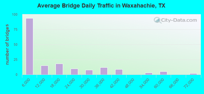
- 2,268,558Total average daily traffic
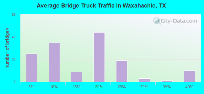
- 461,574Total average daily truck traffic
- National Bridge Inventory (NBI) Registered Bridges for Waxahachie
- No street view available for this location
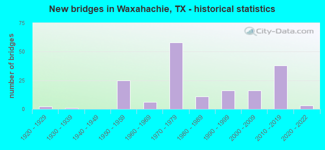
- New bridges - historical statistics
- 21920-1929
- 11930-1939
- 251950-1959
- 61960-1969
- 581970-1979
- 111980-1989
- 161990-1999
- 162000-2009
- 382010-2019
- 32020-2022
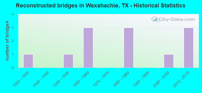
- Reconstructed bridges - Historical Statistics
- 11930-1939
- 01940-1949
- 11950-1959
- 31960-1969
- 01970-1979
- 31980-1989
- 01990-1999
- 12000-2009
- 32010-2019
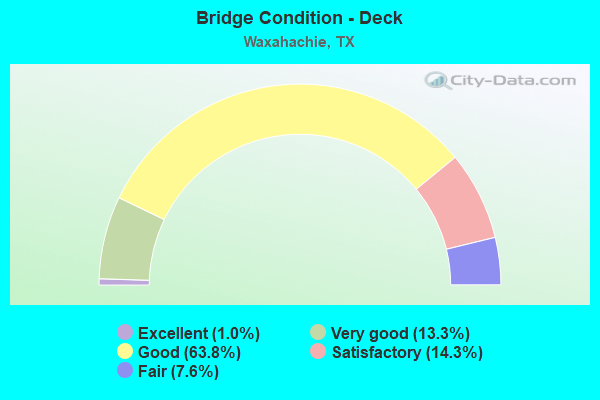
- Bridge Condition - Deck
- 1.0%Excellent
- 13.3%Very good
- 63.8%Good
- 14.3%Satisfactory
- 7.6%Fair
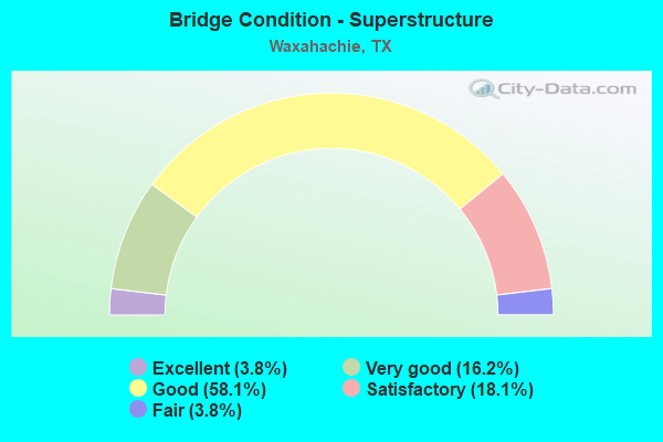
- Bridge Condition - Superstructure
- 3.8%Excellent
- 16.2%Very good
- 58.1%Good
- 18.1%Satisfactory
- 3.8%Fair
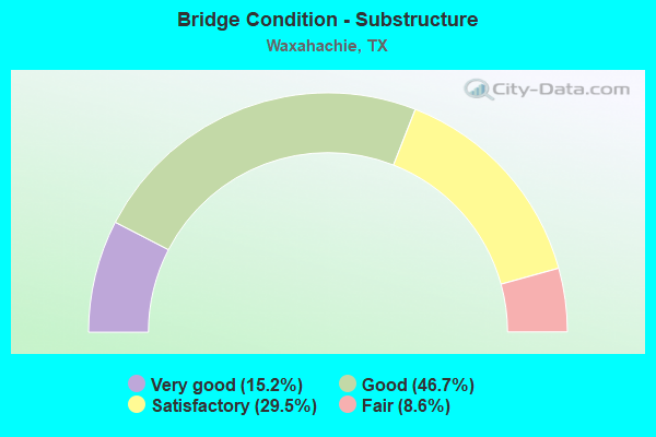
- Bridge Condition - Substructure
- 15.2%Very good
- 46.7%Good
- 29.5%Satisfactory
- 8.6%Fair
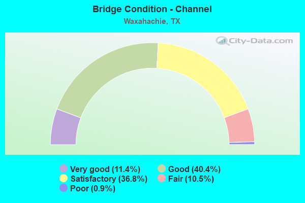
- Bridge Condition - Channel
- 11.4%Very good
- 40.4%Good
- 36.8%Satisfactory
- 10.5%Fair
- 0.9%Poor
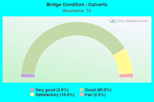
- Bridge Condition - Culverts
- 2.5%Very good
- 80.0%Good
- 15.0%Satisfactory
- 2.5%Fair
Find on map >> Show street view
Structure Number: 180710004808494, Location: 0.10 MI S OF FM 329 (Lat: 32.269183, Lng: -96.870936), Route carried "on" structure: Interstate 35, Year Built: 2010, Status: Open, Structure Length: 1.04m (3.41ft), Average Daily Traffic: 36,335 (year 2020), Truck Traffic: 38%, Average Future Daily Traffic: 49,300 (year 2028), Design Load: HS 25 or greater, Features Intersected: DRAINAGE DITCH
Minimum Vertical Clearance: 30+ m (98+ ft), Kilometerpoint: 19.669, Lanes on structure: 4, Owner: State Highway Agency, Approaching Roadway Width: 14.6m (47.9ft), Skew: 3 degrees, Material/Design: Concrete, Design/Construction: Culvert, Number Of Spans In Main Unit: 3, Length of Maximum Span: 2.4m (7.9ft)
Condition: Channel: Good, Culverts: Very good, Operating Rating: 44.4 metric tons, Method Used To Determine Operating Rating: No rating analysis performed, Inventory Rating: 32.7 metric tons, Method Used To Determine Inventory Rating: No rating analysis performed, Structural Evaluation: Equal to present desirable criteria, Waterway Adequacy: Equal to present minimum criteria, Approach Roadway Alignment: Equal to present desirable criteria, Designated Inspection Frequency: Every 48 months, Inspection Date: Febuary 2018
Find on map >> Show street view
Structure Number: 180710004808495, Location: 5.0 MI S OF FM 66 (Lat: 32.304628, Lng: -96.863783), Route carried "on" structure: Interstate 35, Year Built: 2010, Status: Open, Structure Length: 0.73m (2.40ft), Average Daily Traffic: 36,335 (year 2020), Truck Traffic: 24%, Average Future Daily Traffic: 43,490 (year 2033), Design Load: HS 25 or greater, Features Intersected: DRAW
Minimum Vertical Clearance: 30+ m (98+ ft), Kilometerpoint: 24.766, Lanes on structure: 4, Owner: State Highway Agency, Approaching Roadway Width: 14.6m (47.9ft), Skew: 1 degrees, Material/Design: Concrete, Design/Construction: Culvert, Number Of Spans In Main Unit: 3, Length of Maximum Span: 2.1m (6.9ft)
Condition: Channel: Very good, Culverts: Good, Operating Rating: 44.4 metric tons, Method Used To Determine Operating Rating: No rating analysis performed, Inventory Rating: 32.7 metric tons, Method Used To Determine Inventory Rating: No rating analysis performed, Structural Evaluation: Better than present minimum criteria, Waterway Adequacy: Equal to present minimum criteria, Approach Roadway Alignment: Equal to present desirable criteria, Designated Inspection Frequency: Every 48 months, Inspection Date: Febuary 2018
Find on map >> Show street view
Structure Number: 180710004808496, Location: 0.40 MI N OF FM 329 (Lat: 32.270403, Lng: -96.870683), Route carried "on" structure: Interstate 35, Year Built: 2010, Status: Open, Structure Length: 1.71m (5.61ft), Average Daily Traffic: 36,335 (year 2020), Truck Traffic: 24%, Average Future Daily Traffic: 43,490 (year 2033), Design Load: HS 25 or greater, Features Intersected: DRAW
Minimum Vertical Clearance: 30+ m (98+ ft), Kilometerpoint: 20.688, Lanes on structure: 6, Owner: State Highway Agency, Approaching Roadway Width: 14.6m (47.9ft), Skew: 34 degrees, Material/Design: Concrete, Design/Construction: Culvert, Number Of Spans In Main Unit: 6, Length of Maximum Span: 1.8m (5.9ft)
Condition: Channel: Very good, Culverts: Good, Operating Rating: 44.4 metric tons, Method Used To Determine Operating Rating: No rating analysis performed, Inventory Rating: 32.7 metric tons, Method Used To Determine Inventory Rating: No rating analysis performed, Structural Evaluation: Better than present minimum criteria, Waterway Adequacy: Equal to present minimum criteria, Approach Roadway Alignment: Equal to present desirable criteria, Designated Inspection Frequency: Every 48 months, Inspection Date: Febuary 2018
Find on map >> Show street view
Structure Number: 180710004808517, Location: 3.9 MI S OF FM 66 (Lat: 32.320161, Lng: -96.860450), Route carried "on" structure: Interstate 35, Year Built: 2012, Status: Open, Structure Length: 1.16m (3.81ft), Average Daily Traffic: 36,335 (year 2020), Truck Traffic: 24%, Average Future Daily Traffic: 43,490 (year 2033), Design Load: HS 25 or greater, Features Intersected: DRAW
Minimum Vertical Clearance: 30+ m (98+ ft), Kilometerpoint: 26.453, Lanes on structure: 6, Owner: State Highway Agency, Approaching Roadway Width: 34.7m (113.8ft), Skew: 34 degrees, Material/Design: Concrete, Design/Construction: Culvert, Number Of Spans In Main Unit: 3, Length of Maximum Span: 2.1m (6.9ft)
Condition: Channel: Good, Culverts: Good, Operating Rating: 68.0 metric tons, Method Used To Determine Operating Rating: Assigned rating based on Load Factor Design (LFD) reported in metric tons, Inventory Rating: 40.8 metric tons, Method Used To Determine Inventory Rating: Assigned rating based on Load Factor Design (LFD) reported in metric tons, Structural Evaluation: Better than present minimum criteria, Waterway Adequacy: Superior to present desirable criteria, Approach Roadway Alignment: Equal to present desirable criteria, Designated Inspection Frequency: Every 24 months, Inspection Date: October 2021
Find on map >> Show street view
Structure Number: 180710017205082, Location: 0.65 MI E OF IH 35E (Lat: 32.423344, Lng: -96.853361), Route carried "on" structure: US 287, Year Built: 1971, Status: Open, Structure Length: 13.11m (43.01ft), Average Daily Traffic: 15,770 (year 2013), Truck Traffic: 15%, Average Future Daily Traffic: 22,080 (year 2033), Design Load: HS 20, Features Intersected: UPRR
Minimum Vertical Clearance: 30+ m (98+ ft), Kilometerpoint: 65.299, Lanes on structure: 2, Lanes under structure: 4, Owner: State Highway Agency, Approaching Roadway Width: 12.2m (40.0ft), Material/Design: Prestressed concrete, Design/Construction: Stringer/Multi-beam, Number Of Spans In Main Unit: 5, Length of Maximum Span: 27.4m (89.9ft), Curb-To-Curb Width: 12.8m (42.0ft), Out-to-Out Width: 13.5m (44.3ft)
Condition: Deck: Good, Superstructure: Good, Substructure: Good, Operating Rating: 68.0 metric tons, Method Used To Determine Operating Rating: Load Factor (LF), Inventory Rating: 34.5 metric tons, Method Used To Determine Inventory Rating: Load Factor (LF), Structural Evaluation: Better than present minimum criteria, Deck Geometry: Equal to present desirable criteria, Underclear: Superior to present desirable criteria, Approach Roadway Alignment: Equal to present desirable criteria, Designated Inspection Frequency: Every 24 months, Inspection Date: Febuary 2020, Deck Structure Type: Concrete Cast-file-Place
Find on map >> Show street view
Structure Number: 180710017205083, Location: 0.65 MI E OF IH 35E (Lat: 32.423156, Lng: -96.853444), Route carried "on" structure: US 287, Year Built: 1971, Status: Open, Structure Length: 13.11m (43.01ft), Average Daily Traffic: 15,770 (year 2013), Truck Traffic: 15%, Average Future Daily Traffic: 22,080 (year 2033), Design Load: HS 20, Features Intersected: UPRR
Minimum Vertical Clearance: 30+ m (98+ ft), Kilometerpoint: 65.299, Lanes on structure: 2, Lanes under structure: 4, Owner: State Highway Agency, Approaching Roadway Width: 12.2m (40.0ft), Material/Design: Prestressed concrete, Design/Construction: Stringer/Multi-beam, Number Of Spans In Main Unit: 5, Length of Maximum Span: 27.4m (89.9ft), Curb-To-Curb Width: 12.8m (42.0ft), Out-to-Out Width: 13.5m (44.3ft)
Condition: Deck: Good, Superstructure: Good, Substructure: Good, Operating Rating: 68.0 metric tons, Method Used To Determine Operating Rating: Load Factor (LF), Inventory Rating: 34.5 metric tons, Method Used To Determine Inventory Rating: Load Factor (LF), Structural Evaluation: Better than present minimum criteria, Deck Geometry: Equal to present desirable criteria, Underclear: Superior to present desirable criteria, Approach Roadway Alignment: Equal to present desirable criteria, Designated Inspection Frequency: Every 24 months, Inspection Date: Febuary 2020, Deck Structure Type: Concrete Cast-file-Place
Find on map >> Show street view
Structure Number: 180710017205086, Location: 0.55 MI SE OF US 77 (Lat: 32.416814, Lng: -96.830947), Route carried "on" structure: ServiceUS 287, Year Built: 1971, Status: Open, Structure Length: 5.21m (17.09ft), Average Daily Traffic: 7,330 (year 2013), Truck Traffic: 16%, Average Future Daily Traffic: 10,270 (year 2033), Design Load: HS 20, Features Intersected: UPPER MUSTANG CREEK
Minimum Vertical Clearance: 30+ m (98+ ft), Kilometerpoint: 67.501, Lanes on structure: 2, Owner: State Highway Agency, Approaching Roadway Width: 9.1m (29.9ft), Skew: 3 degrees, Material/Design: Concrete, Design/Construction: Stringer/Multi-beam, Number Of Spans In Main Unit: 4, Length of Maximum Span: 13.1m (43.0ft), Curb-To-Curb Width: 10.4m (34.1ft), Out-to-Out Width: 11.0m (36.1ft)
Condition: Deck: Satisfactory, Superstructure: Good, Substructure: Satisfactory, Channel: Satisfactory, Operating Rating: 68.0 metric tons, Method Used To Determine Operating Rating: Load Factor (LF), Inventory Rating: 40.8 metric tons, Method Used To Determine Inventory Rating: Load Factor (LF), Structural Evaluation: Equal to present minimum criteria, Deck Geometry: Somewhat better than minimum adequacy, Waterway Adequacy: Equal to present minimum criteria, Approach Roadway Alignment: Equal to present desirable criteria, Length Of Structure Improvement: 5.21m (17.09ft), Designated Inspection Frequency: Every 24 months, Inspection Date: March 2020, Bridge Improvement Cost: $116,000, Roadway Improvement Cost: $29,000, Total Project Cost: $145,000, Deck Structure Type: Concrete Cast-file-Place
Find on map >> Show street view
Structure Number: 180710017205087, Location: 0.55 MI SE OF US 77 (Lat: 32.416436, Lng: -96.831031), Route carried "on" structure: US 287, Year Built: 1971, Status: Open, Structure Length: 6.10m (20.01ft), Average Daily Traffic: 8,980 (year 2013), Truck Traffic: 15%, Average Future Daily Traffic: 12,570 (year 2033), Design Load: HS 20, Features Intersected: UPPER MUSTANG CREEK
Minimum Vertical Clearance: 30+ m (98+ ft), Kilometerpoint: 67.538, Lanes on structure: 2, Owner: State Highway Agency, Approaching Roadway Width: 12.2m (40.0ft), Skew: 4 degrees, Material/Design: Prestressed concrete, Design/Construction: Stringer/Multi-beam, Number Of Spans In Main Unit: 4, Length of Maximum Span: 15.2m (49.9ft), Curb-To-Curb Width: 12.8m (42.0ft), Out-to-Out Width: 13.5m (44.3ft)
Condition: Deck: Good, Superstructure: Good, Substructure: Good, Channel: Satisfactory, Operating Rating: 67.1 metric tons, Method Used To Determine Operating Rating: Load Factor (LF), Inventory Rating: 36.3 metric tons, Method Used To Determine Inventory Rating: Load Factor (LF), Structural Evaluation: Better than present minimum criteria, Deck Geometry: Equal to present desirable criteria, Waterway Adequacy: Equal to present minimum criteria, Approach Roadway Alignment: Equal to present desirable criteria, Designated Inspection Frequency: Every 24 months, Inspection Date: March 2020, Deck Structure Type: Concrete Cast-file-Place
Find on map >> Show street view
Structure Number: 180710017205088, Location: 0.55 MI SE OF US 77 (Lat: 32.416186, Lng: -96.831394), Route carried "on" structure: US 287, Year Built: 1971, Status: Open, Structure Length: 6.10m (20.01ft), Average Daily Traffic: 8,980 (year 2013), Truck Traffic: 15%, Average Future Daily Traffic: 12,570 (year 2033), Design Load: HS 20, Features Intersected: UPPER MUSTANG CREEK
Minimum Vertical Clearance: 30+ m (98+ ft), Kilometerpoint: 67.555, Lanes on structure: 3, Owner: State Highway Agency, Approaching Roadway Width: 11.0m (36.1ft), Skew: 4 degrees, Material/Design: Prestressed concrete, Design/Construction: Stringer/Multi-beam, Number Of Spans In Main Unit: 4, Length of Maximum Span: 15.2m (49.9ft), Curb-To-Curb Width: 16.7m (54.8ft), Out-to-Out Width: 17.5m (57.4ft)
Condition: Deck: Satisfactory, Superstructure: Good, Substructure: Good, Channel: Satisfactory, Operating Rating: 66.2 metric tons, Method Used To Determine Operating Rating: Load Factor (LF), Inventory Rating: 35.4 metric tons, Method Used To Determine Inventory Rating: Load Factor (LF), Structural Evaluation: Better than present minimum criteria, Deck Geometry: Equal to present minimum criteria, Waterway Adequacy: Equal to present minimum criteria, Approach Roadway Alignment: Equal to present desirable criteria, Designated Inspection Frequency: Every 24 months, Inspection Date: March 2020, Deck Structure Type: Concrete Cast-file-Place
Find on map >> Show street view
Structure Number: 180710017205089, Location: 0.8 MI SE OF US 77 (Lat: 32.413406, Lng: -96.831508), Route carried "on" structure: ServiceUS 287, Year Built: 1971, Status: Open, Structure Length: 0.79m (2.59ft), Average Daily Traffic: 9,680 (year 2013), Truck Traffic: 16%, Average Future Daily Traffic: 13,550 (year 2033), Design Load: HS 20, Features Intersected: DRAIN
Minimum Vertical Clearance: 30+ m (98+ ft), Kilometerpoint: 67.887, Lanes on structure: 2, Owner: State Highway Agency, Approaching Roadway Width: 7.9m (25.9ft), Material/Design: Concrete, Design/Construction: Culvert, Number Of Spans In Main Unit: 4, Length of Maximum Span: 1.8m (5.9ft)
Condition: Channel: Satisfactory, Culverts: Good, Operating Rating: 39.9 metric tons, Method Used To Determine Operating Rating: Load Factor (LF), Inventory Rating: 23.6 metric tons, Method Used To Determine Inventory Rating: Load Factor (LF), Structural Evaluation: Somewhat better than minimum adequacy, Waterway Adequacy: Better than present minimum criteria, Approach Roadway Alignment: Equal to present desirable criteria, Designated Inspection Frequency: Every 24 months, Inspection Date: April 2020
Find on map >> Show street view
Structure Number: 18071001720509, Location: 0.55 MI SE OF US 77 (Lat: 32.412181, Lng: -96.829314), Route carried "on" structure: ServiceUS 287, Year Built: 1971, Status: Open, Structure Length: 4.11m (13.48ft), Average Daily Traffic: 1,990 (year 2013), Average Future Daily Traffic: 2,790 (year 2033), Design Load: HS 20, Features Intersected: MUSTANG CREEK
Minimum Vertical Clearance: 30+ m (98+ ft), Kilometerpoint: 68.003, Lanes on structure: 2, Owner: State Highway Agency, Approaching Roadway Width: 9.8m (32.2ft), Skew: 4 degrees, Material/Design: Prestressed concrete, Design/Construction: Stringer/Multi-beam, Number Of Spans In Main Unit: 3, Length of Maximum Span: 15.2m (49.9ft), Curb-To-Curb Width: 11.0m (36.1ft), Out-to-Out Width: 11.7m (38.4ft)
Condition: Deck: Good, Superstructure: Good, Substructure: Good, Channel: Good, Operating Rating: 63.5 metric tons, Method Used To Determine Operating Rating: Load Factor (LF), Inventory Rating: 36.3 metric tons, Method Used To Determine Inventory Rating: Load Factor (LF), Structural Evaluation: Better than present minimum criteria, Deck Geometry: Equal to present minimum criteria, Waterway Adequacy: Equal to present minimum criteria, Approach Roadway Alignment: Equal to present desirable criteria, Designated Inspection Frequency: Every 24 months, Inspection Date: March 2020, Deck Structure Type: Concrete Cast-file-Place
Find on map >> Show street view
Structure Number: 180710017205091, Location: 0.2 MI SE OF FM 813 (Lat: 32.411572, Lng: -96.827503), Route carried "on" structure: US 287, Year Built: 1971, Status: Open, Structure Length: 0.94m (3.08ft), Average Daily Traffic: 33,056 (year 2020), Truck Traffic: 15%, Average Future Daily Traffic: 32,860 (year 2033), Design Load: HS 20, Features Intersected: DRAW
Minimum Vertical Clearance: 30+ m (98+ ft), Kilometerpoint: 68.190, Lanes on structure: 8, Owner: State Highway Agency, Approaching Roadway Width: 39.0m (128.0ft), Skew: 29 degrees, Material/Design: Concrete, Design/Construction: Culvert, Number Of Spans In Main Unit: 4, Length of Maximum Span: 1.8m (5.9ft)
Condition: Channel: Good, Culverts: Good, Operating Rating: 39.9 metric tons, Method Used To Determine Operating Rating: Load Factor (LF), Inventory Rating: 23.6 metric tons, Method Used To Determine Inventory Rating: Load Factor (LF), Structural Evaluation: Somewhat better than minimum adequacy, Waterway Adequacy: Equal to present minimum criteria, Approach Roadway Alignment: Equal to present desirable criteria, Designated Inspection Frequency: Every 24 months, Inspection Date: April 2020
Find on map >> Show street view
Structure Number: 180710017205092, Location: 0.9 MI SE OF FM 813 (Lat: 32.402508, Lng: -96.822278), Route carried "on" structure: ServiceUS 287, Year Built: 1971, Status: Open, Structure Length: 0.67m (2.20ft), Average Daily Traffic: 1,990 (year 2013), Average Future Daily Traffic: 2,790 (year 2033), Design Load: HS 20, Features Intersected: DRAW
Minimum Vertical Clearance: 30+ m (98+ ft), Kilometerpoint: 69.340, Lanes on structure: 2, Owner: State Highway Agency, Approaching Roadway Width: 7.9m (25.9ft), Skew: 4 degrees, Material/Design: Concrete, Design/Construction: Culvert, Number Of Spans In Main Unit: 2, Length of Maximum Span: 2.1m (6.9ft)
Condition: Channel: Good, Culverts: Good, Operating Rating: 39.9 metric tons, Method Used To Determine Operating Rating: Load Factor (LF), Inventory Rating: 23.6 metric tons, Method Used To Determine Inventory Rating: Load Factor (LF), Structural Evaluation: Equal to present minimum criteria, Waterway Adequacy: Equal to present minimum criteria, Approach Roadway Alignment: Equal to present desirable criteria, Designated Inspection Frequency: Every 24 months, Inspection Date: April 2020
Find on map >> Show street view
Structure Number: 180710017205093, Location: 1.4 MI SE OF FM 813 (Lat: 32.395800, Lng: -96.816617), Route carried "on" structure: ServiceUS 287, Year Built: 1971, Status: Open, Structure Length: 1.16m (3.81ft), Average Daily Traffic: 1,830 (year 2013), Average Future Daily Traffic: 2,560 (year 2033), Design Load: HS 20, Features Intersected: DRAW
Minimum Vertical Clearance: 30+ m (98+ ft), Kilometerpoint: 70.211, Lanes on structure: 2, Owner: State Highway Agency, Approaching Roadway Width: 7.9m (25.9ft), Material/Design: Concrete, Design/Construction: Culvert, Number Of Spans In Main Unit: 5, Length of Maximum Span: 2.1m (6.9ft), Curb-To-Curb Width: 8.5m (27.9ft), Out-to-Out Width: 16.9m (55.4ft)
Condition: Channel: Satisfactory, Culverts: Good, Operating Rating: 39.9 metric tons, Method Used To Determine Operating Rating: Load Factor (LF), Inventory Rating: 23.6 metric tons, Method Used To Determine Inventory Rating: Load Factor (LF), Structural Evaluation: Equal to present minimum criteria, Deck Geometry: High priority of corrective action, Waterway Adequacy: Equal to present minimum criteria, Approach Roadway Alignment: Equal to present desirable criteria, Designated Inspection Frequency: Every 24 months, Inspection Date: April 2020, Deck Structure Type: Concrete Cast-file-Place, Wearing Surface/Protective System: Wearing Surface: Bituminous
Find on map >> Show street view
Structure Number: 180710017205094, Location: 1.4 MI SE OF FM 813 (Lat: 32.395647, Lng: -96.817011), Route carried "on" structure: US 287, Year Built: 1971, Status: Open, Structure Length: 1.16m (3.81ft), Average Daily Traffic: 33,056 (year 2020), Truck Traffic: 15%, Average Future Daily Traffic: 32,860 (year 2033), Design Load: HS 20, Features Intersected: DRAW
Minimum Vertical Clearance: 30+ m (98+ ft), Kilometerpoint: 70.211, Lanes on structure: 4, Owner: State Highway Agency, Approaching Roadway Width: 23.2m (76.1ft), Skew: 20 degrees, Material/Design: Concrete, Design/Construction: Culvert, Number Of Spans In Main Unit: 5, Length of Maximum Span: 2.1m (6.9ft)
Condition: Channel: Good, Culverts: Good, Operating Rating: 39.9 metric tons, Method Used To Determine Operating Rating: Load Factor (LF), Inventory Rating: 23.6 metric tons, Method Used To Determine Inventory Rating: Load Factor (LF), Structural Evaluation: Somewhat better than minimum adequacy, Waterway Adequacy: Equal to present minimum criteria, Approach Roadway Alignment: Equal to present desirable criteria, Designated Inspection Frequency: Every 24 months, Inspection Date: April 2020
Find on map >> Show street view
Structure Number: 180710017205095, Location: 1.4 MI SE OF FM 813 (Lat: 32.395469, Lng: -96.817375), Route carried "on" structure: ServiceUS 287, Year Built: 1971, Status: Open, Structure Length: 1.16m (3.81ft), Average Daily Traffic: 1,990 (year 2013), Average Future Daily Traffic: 2,790 (year 2033), Design Load: HS 20, Features Intersected: DRAW
Minimum Vertical Clearance: 30+ m (98+ ft), Kilometerpoint: 70.211, Lanes on structure: 2, Owner: State Highway Agency, Approaching Roadway Width: 7.9m (25.9ft), Material/Design: Concrete, Design/Construction: Culvert, Number Of Spans In Main Unit: 5, Length of Maximum Span: 2.1m (6.9ft), Curb-To-Curb Width: 8.5m (27.9ft), Out-to-Out Width: 16.9m (55.4ft)
Condition: Channel: Good, Culverts: Good, Operating Rating: 39.9 metric tons, Method Used To Determine Operating Rating: Load Factor (LF), Inventory Rating: 23.6 metric tons, Method Used To Determine Inventory Rating: Load Factor (LF), Structural Evaluation: Equal to present minimum criteria, Deck Geometry: High priority of corrective action, Waterway Adequacy: Equal to present minimum criteria, Approach Roadway Alignment: Equal to present desirable criteria, Designated Inspection Frequency: Every 24 months, Inspection Date: April 2020, Deck Structure Type: Concrete Cast-file-Place, Wearing Surface/Protective System: Wearing Surface: Bituminous
Find on map >> Show street view
Structure Number: 180710017205097, Location: 1.8 MI SE OF FM 813 (Lat: 32.391286, Lng: -96.811336), Route carried "on" structure: ServiceUS 287, Year Built: 1971, Status: Open, Structure Length: 1.43m (4.69ft), Average Daily Traffic: 11,000 (year 2008), Truck Traffic: 17%, Average Future Daily Traffic: 21,540 (year 2028), Design Load: HS 20, Features Intersected: DRAW
Minimum Vertical Clearance: 30+ m (98+ ft), Kilometerpoint: 70.900, Lanes on structure: 2, Owner: State Highway Agency, Approaching Roadway Width: 8.5m (27.9ft), Skew: 4 degrees, Material/Design: Concrete, Design/Construction: Culvert, Number Of Spans In Main Unit: 5, Length of Maximum Span: 1.8m (5.9ft)
Condition: Channel: Good, Culverts: Good, Operating Rating: 39.9 metric tons, Method Used To Determine Operating Rating: Load Factor (LF), Inventory Rating: 23.6 metric tons, Method Used To Determine Inventory Rating: Load Factor (LF), Structural Evaluation: Somewhat better than minimum adequacy, Waterway Adequacy: Equal to present minimum criteria, Approach Roadway Alignment: Equal to present desirable criteria, Designated Inspection Frequency: Every 24 months, Inspection Date: April 2020
Find on map >> Show street view
Structure Number: 180710017205098, Location: 0.05 MI SE OF FM 878 (Lat: 32.389853, Lng: -96.813169), Route carried "on" structure: US 287, Year Built: 1971, Status: Open, Structure Length: 1.01m (3.31ft), Average Daily Traffic: 23,030 (year 2020), Truck Traffic: 15%, Average Future Daily Traffic: 32,860 (year 2033), Design Load: HS 20, Features Intersected: DRAW
Minimum Vertical Clearance: 30+ m (98+ ft), Kilometerpoint: 70.950, Lanes on structure: 5, Owner: State Highway Agency, Approaching Roadway Width: 25.9m (85.0ft), Skew: 20 degrees, Material/Design: Concrete, Design/Construction: Culvert, Number Of Spans In Main Unit: 5, Length of Maximum Span: 1.8m (5.9ft)
Condition: Channel: Good, Culverts: Good, Operating Rating: 39.9 metric tons, Method Used To Determine Operating Rating: Load Factor (LF), Inventory Rating: 23.6 metric tons, Method Used To Determine Inventory Rating: Load Factor (LF), Structural Evaluation: Somewhat better than minimum adequacy, Waterway Adequacy: Equal to present minimum criteria, Approach Roadway Alignment: Equal to present desirable criteria, Designated Inspection Frequency: Every 24 months, Inspection Date: April 2020
Find on map >> Show street view
Structure Number: 180710017205099, Location: 0.25 MI SE OF FM 878 (Lat: 32.386961, Lng: -96.811381), Route carried "on" structure: US 287, Year Built: 1971, Status: Open, Structure Length: 10.06m (33.01ft), Average Daily Traffic: 12,569 (year 2019), Truck Traffic: 15%, Average Future Daily Traffic: 9,190 (year 2033), Design Load: HS 20, Features Intersected: UPRR
Minimum Vertical Clearance: 30+ m (98+ ft), Kilometerpoint: 71.273, Lanes on structure: 2, Owner: State Highway Agency, Approaching Roadway Width: 12.2m (40.0ft), Skew: 3 degrees, Material/Design: Prestressed concrete, Design/Construction: Stringer/Multi-beam, Number Of Spans In Main Unit: 5, Length of Maximum Span: 22.9m (75.1ft), Curb-To-Curb Width: 12.8m (42.0ft), Out-to-Out Width: 13.3m (43.6ft)
Condition: Deck: Very good, Superstructure: Good, Substructure: Good, Operating Rating: 64.4 metric tons, Method Used To Determine Operating Rating: Load Factor (LF), Inventory Rating: 28.1 metric tons, Method Used To Determine Inventory Rating: Load Factor (LF), Structural Evaluation: Better than present minimum criteria, Deck Geometry: Equal to present desirable criteria, Underclear: Equal to present minimum criteria, Approach Roadway Alignment: Equal to present desirable criteria, Designated Inspection Frequency: Every 24 months, Inspection Date: Febuary 2020, Deck Structure Type: Concrete Cast-file-Place, Wearing Surface/Protective System: Wearing Surface: Bituminous
Find on map >> Show street view
Structure Number: 1807100172051, Location: 0.25 MI SE OF FM 878 (Lat: 32.387011, Lng: -96.810992), Route carried "on" structure: US 287, Year Built: 1971, Status: Open, Structure Length: 9.94m (32.61ft), Average Daily Traffic: 11,398 (year 2020), Truck Traffic: 15%, Average Future Daily Traffic: 9,190 (year 2033), Design Load: HS 20, Features Intersected: UPRR
Minimum Vertical Clearance: 30+ m (98+ ft), Kilometerpoint: 71.257, Lanes on structure: 2, Owner: State Highway Agency, Approaching Roadway Width: 12.2m (40.0ft), Skew: 3 degrees, Material/Design: Prestressed concrete, Design/Construction: Stringer/Multi-beam, Number Of Spans In Main Unit: 5, Length of Maximum Span: 22.9m (75.1ft), Curb-To-Curb Width: 12.8m (42.0ft), Out-to-Out Width: 13.3m (43.6ft)
Condition: Deck: Very good, Superstructure: Good, Substructure: Satisfactory, Operating Rating: 64.4 metric tons, Method Used To Determine Operating Rating: Load Factor (LF), Inventory Rating: 29.0 metric tons, Method Used To Determine Inventory Rating: Load Factor (LF), Structural Evaluation: Equal to present minimum criteria, Deck Geometry: Equal to present desirable criteria, Underclear: Superior to present desirable criteria, Approach Roadway Alignment: Equal to present desirable criteria, Length Of Structure Improvement: 10.03m (32.91ft), Designated Inspection Frequency: Every 24 months, Inspection Date: Febuary 2020, Bridge Improvement Cost: $276,000, Roadway Improvement Cost: $69,000, Total Project Cost: $345,000, Deck Structure Type: Concrete Cast-file-Place, Wearing Surface/Protective System: Wearing Surface: Bituminous
Find on map >> Show street view
Structure Number: 180710017205101, Location: 1.6 MI SE OF FM 878 (Lat: 32.384781, Lng: -96.810158), Route carried "on" structure: US 287, Year Built: 1971, Status: Open, Structure Length: 6.10m (20.01ft), Average Daily Traffic: 11,398 (year 2020), Truck Traffic: 15%, Average Future Daily Traffic: 9,190 (year 2033), Design Load: HS 20, Features Intersected: LOWER MUSTANG CREEK
Minimum Vertical Clearance: 30+ m (98+ ft), Kilometerpoint: 71.556, Lanes on structure: 2, Owner: State Highway Agency, Approaching Roadway Width: 12.2m (40.0ft), Material/Design: Concrete, Design/Construction: Stringer/Multi-beam, Number Of Spans In Main Unit: 5, Length of Maximum Span: 12.2m (40.0ft), Curb-To-Curb Width: 12.8m (42.0ft), Out-to-Out Width: 13.5m (44.3ft)
Condition: Deck: Good, Superstructure: Good, Substructure: Satisfactory, Channel: Good, Operating Rating: 54.4 metric tons, Method Used To Determine Operating Rating: Assigned rating based on Load Factor Design (LFD) reported in metric tons, Inventory Rating: 32.7 metric tons, Method Used To Determine Inventory Rating: Assigned rating based on Load Factor Design (LFD) reported in metric tons, Structural Evaluation: Equal to present minimum criteria, Deck Geometry: Equal to present desirable criteria, Waterway Adequacy: Equal to present desirable criteria, Approach Roadway Alignment: Equal to present desirable criteria, Designated Inspection Frequency: Every 24 months, Inspection Date: January 2020, Deck Structure Type: Concrete Cast-file-Place, Wearing Surface/Protective System: Wearing Surface: Bituminous
Find on map >> Show street view
Structure Number: 180710017205102, Location: 1.6 MI SE OF FM 878 (Lat: 32.384744, Lng: -96.810314), Route carried "on" structure: US 287, Year Built: 1971, Status: Open, Structure Length: 6.10m (20.01ft), Average Daily Traffic: 12,569 (year 2019), Truck Traffic: 15%, Average Future Daily Traffic: 9,190 (year 2033), Design Load: HS 20, Features Intersected: LOWER MUSTANG CREEK
Minimum Vertical Clearance: 30+ m (98+ ft), Kilometerpoint: 71.551, Lanes on structure: 2, Owner: State Highway Agency, Approaching Roadway Width: 12.2m (40.0ft), Material/Design: Concrete, Design/Construction: Stringer/Multi-beam, Number Of Spans In Main Unit: 5, Length of Maximum Span: 12.2m (40.0ft), Curb-To-Curb Width: 12.8m (42.0ft), Out-to-Out Width: 13.5m (44.3ft)
Condition: Deck: Satisfactory, Superstructure: Good, Substructure: Good, Channel: Good, Operating Rating: 54.4 metric tons, Method Used To Determine Operating Rating: Assigned rating based on Load Factor Design (LFD) reported in metric tons, Inventory Rating: 32.7 metric tons, Method Used To Determine Inventory Rating: Assigned rating based on Load Factor Design (LFD) reported in metric tons, Structural Evaluation: Better than present minimum criteria, Deck Geometry: Equal to present desirable criteria, Waterway Adequacy: Equal to present desirable criteria, Approach Roadway Alignment: Equal to present desirable criteria, Designated Inspection Frequency: Every 24 months, Inspection Date: January 2020, Deck Structure Type: Concrete Cast-file-Place, Wearing Surface/Protective System: Wearing Surface: Bituminous
Find on map >> Show street view
Structure Number: 180710017205104, Location: 1.0 MI S OF FM 878 (Lat: 32.376689, Lng: -96.807781), Route carried "on" structure: US 287, Year Built: 1971, Status: Open, Structure Length: 0.85m (2.79ft), Average Daily Traffic: 23,030 (year 2020), Truck Traffic: 15%, Average Future Daily Traffic: 18,390 (year 2033), Design Load: HS 20, Features Intersected: DRAW
Minimum Vertical Clearance: 30+ m (98+ ft), Kilometerpoint: 72.538, Lanes on structure: 4, Owner: State Highway Agency, Approaching Roadway Width: 25.6m (84.0ft), Skew: 24 degrees, Material/Design: Concrete, Design/Construction: Culvert, Number Of Spans In Main Unit: 3, Length of Maximum Span: 1.8m (5.9ft)
Condition: Channel: Satisfactory, Culverts: Good, Operating Rating: 39.9 metric tons, Method Used To Determine Operating Rating: Load Factor (LF), Inventory Rating: 23.6 metric tons, Method Used To Determine Inventory Rating: Load Factor (LF), Structural Evaluation: Somewhat better than minimum adequacy, Waterway Adequacy: Equal to present minimum criteria, Approach Roadway Alignment: Equal to present desirable criteria, Designated Inspection Frequency: Every 24 months, Inspection Date: January 2020
Find on map >> Show street view
Structure Number: 180710017205105, Location: 1.6 MI W OF FM 664 (Lat: 32.431181, Lng: -96.899986), Route carried "on" structure: ServiceUS 287, Year Built: 1973, Status: Open, Structure Length: 2.61m (8.56ft), Average Daily Traffic: 160 (year 2013), Truck Traffic: 11%, Average Future Daily Traffic: 230 (year 2033), Design Load: HS 20, Features Intersected: LONG BRANCH
Minimum Vertical Clearance: 30+ m (98+ ft), Kilometerpoint: 60.695, Lanes on structure: 2, Owner: State Highway Agency, Approaching Roadway Width: 7.3m (24.0ft), Skew: 3 degrees, Material/Design: Concrete, Design/Construction: Stringer/Multi-beam, Number Of Spans In Main Unit: 2, Length of Maximum Span: 13.0m (42.7ft), Curb-To-Curb Width: 10.4m (34.1ft), Out-to-Out Width: 11.1m (36.4ft)
Condition: Deck: Good, Superstructure: Good, Substructure: Satisfactory, Channel: Satisfactory, Operating Rating: 54.4 metric tons, Method Used To Determine Operating Rating: Load Factor (LF), Inventory Rating: 32.7 metric tons, Method Used To Determine Inventory Rating: Load Factor (LF), Structural Evaluation: Equal to present minimum criteria, Deck Geometry: Better than present minimum criteria, Waterway Adequacy: Equal to present minimum criteria, Approach Roadway Alignment: Equal to present desirable criteria, Designated Inspection Frequency: Every 24 months, Inspection Date: Febuary 2020, Deck Structure Type: Concrete Cast-file-Place
Find on map >> Show street view
Structure Number: 180710017205106, Location: 1.6 MI W OF FM 664 (Lat: 32.430575, Lng: -96.899950), Route carried "on" structure: US 287, Year Built: 1973, Status: Open, Structure Length: 5.33m (17.49ft), Average Daily Traffic: 18,540 (year 2020), Truck Traffic: 15%, Average Future Daily Traffic: 16,680 (year 2033), Design Load: HS 20, Features Intersected: LONG BRANCH
Minimum Vertical Clearance: 30+ m (98+ ft), Kilometerpoint: 60.737, Lanes on structure: 2, Owner: State Highway Agency, Approaching Roadway Width: 12.2m (40.0ft), Skew: 3 degrees, Material/Design: Prestressed concrete, Design/Construction: Stringer/Multi-beam, Number Of Spans In Main Unit: 3, Length of Maximum Span: 18.3m (60.0ft), Curb-To-Curb Width: 12.8m (42.0ft), Out-to-Out Width: 13.5m (44.3ft)
Condition: Deck: Good, Superstructure: Good, Substructure: Good, Channel: Satisfactory, Operating Rating: 54.4 metric tons, Method Used To Determine Operating Rating: Load Factor (LF), Inventory Rating: 32.7 metric tons, Method Used To Determine Inventory Rating: Load Factor (LF), Structural Evaluation: Better than present minimum criteria, Deck Geometry: Equal to present desirable criteria, Waterway Adequacy: Equal to present minimum criteria, Approach Roadway Alignment: Equal to present desirable criteria, Designated Inspection Frequency: Every 24 months, Inspection Date: Febuary 2020, Deck Structure Type: Concrete Cast-file-Place
Find on map >> Show street view
Structure Number: 180710017205107, Location: US 287 AT US 287 BUS (Lat: 32.429967, Lng: -96.900161), Route carried "on" structure: US 287, Year Built: 1973, Status: Open, Structure Length: 15.39m (50.49ft), Average Daily Traffic: 16,717 (year 2020), Truck Traffic: 15%, Average Future Daily Traffic: 16,680 (year 2033), Design Load: HS 20, Features Intersected: US 287 BUS & LONG BRANCH
Minimum Vertical Clearance: 30+ m (98+ ft), Kilometerpoint: 60.695, Lanes on structure: 2, Lanes under structure: 1, Owner: State Highway Agency, Approaching Roadway Width: 11.0m (36.1ft), Skew: 9 degrees, Material/Design: Prestressed concrete, Design/Construction: Stringer/Multi-beam, Number Of Spans In Main Unit: 4, Number Of Approach Spans: 2, Length of Maximum Span: 30.5m (100.1ft), Curb-To-Curb Width: 12.8m (42.0ft), Out-to-Out Width: 13.4m (44.0ft)
Condition: Deck: Good, Superstructure: Good, Substructure: Good, Channel: Good, Operating Rating: 54.4 metric tons, Method Used To Determine Operating Rating: Load Factor (LF), Inventory Rating: 30.8 metric tons, Method Used To Determine Inventory Rating: Load Factor (LF), Structural Evaluation: Better than present minimum criteria, Deck Geometry: Equal to present desirable criteria, Underclear: Equal to present minimum criteria, Waterway Adequacy: Superior to present desirable criteria, Approach Roadway Alignment: Equal to present desirable criteria, Designated Inspection Frequency: Every 24 months, Inspection Date: Febuary 2020, Deck Structure Type: Concrete Cast-file-Place, Wearing Surface/Protective System: Wearing Surface: Bituminous
Find on map >> Show street view
Structure Number: 18071001720511, Location: 0.1 MI W OF US 287 BUS (Lat: 32.428406, Lng: -96.899972), Route carried "on" structure: ServiceUS 287, Year Built: 1973, Status: Open, Structure Length: 2.50m (8.20ft), Average Daily Traffic: 790 (year 2013), Truck Traffic: 14%, Average Future Daily Traffic: 1,100 (year 2033), Design Load: HS 20, Features Intersected: LONG BRANCH
Minimum Vertical Clearance: 30+ m (98+ ft), Kilometerpoint: 60.782, Lanes on structure: 2, Owner: State Highway Agency, Approaching Roadway Width: 7.3m (24.0ft), Skew: 1 degrees, Material/Design: Concrete, Design/Construction: Stringer/Multi-beam, Number Of Spans In Main Unit: 2, Length of Maximum Span: 12.5m (41.0ft), Curb-To-Curb Width: 10.4m (34.1ft), Out-to-Out Width: 11.1m (36.4ft)
Condition: Deck: Good, Superstructure: Good, Substructure: Satisfactory, Channel: Satisfactory, Operating Rating: 54.4 metric tons, Method Used To Determine Operating Rating: Load Factor (LF), Inventory Rating: 32.7 metric tons, Method Used To Determine Inventory Rating: Load Factor (LF), Structural Evaluation: Equal to present minimum criteria, Deck Geometry: Equal to present minimum criteria, Waterway Adequacy: Equal to present minimum criteria, Approach Roadway Alignment: Equal to present minimum criteria, Designated Inspection Frequency: Every 24 months, Inspection Date: Febuary 2020, Deck Structure Type: Concrete Cast-file-Place
Find on map >> Show street view
Structure Number: 180710017205111, Location: 1.4 MI W OF FM 664 (Lat: 32.430244, Lng: -96.898275), Route carried "on" structure: US 287, Year Built: 1973, Status: Open, Structure Length: 5.94m (19.49ft), Average Daily Traffic: 18,540 (year 2020), Truck Traffic: 15%, Average Future Daily Traffic: 16,680 (year 2033), Design Load: HS 20, Features Intersected: FRONTAGE ROAD CONNECTOR
Minimum Vertical Clearance: 30+ m (98+ ft), Kilometerpoint: 60.909, Lanes on structure: 2, Lanes under structure: 2, Owner: State Highway Agency, Approaching Roadway Width: 12.2m (40.0ft), Material/Design: Prestressed concrete, Design/Construction: Stringer/Multi-beam, Number Of Spans In Main Unit: 1, Number Of Approach Spans: 2, Length of Maximum Span: 25.9m (85.0ft), Curb-To-Curb Width: 12.8m (42.0ft), Out-to-Out Width: 13.4m (44.0ft)
Condition: Deck: Good, Superstructure: Good, Substructure: Good, Operating Rating: 54.4 metric tons, Method Used To Determine Operating Rating: Load Factor (LF), Inventory Rating: 32.7 metric tons, Method Used To Determine Inventory Rating: Load Factor (LF), Structural Evaluation: Better than present minimum criteria, Deck Geometry: Equal to present desirable criteria, Underclear: Better than present minimum criteria, Approach Roadway Alignment: Equal to present desirable criteria, Designated Inspection Frequency: Every 24 months, Inspection Date: Febuary 2020, Deck Structure Type: Concrete Cast-file-Place
Find on map >> Show street view
Structure Number: 180710017205112, Location: 1.4 MI W OF FM 664 (Lat: 32.429600, Lng: -96.898369), Route carried "on" structure: US 287, Year Built: 1973, Status: Open, Structure Length: 5.94m (19.49ft), Average Daily Traffic: 16,717 (year 2020), Truck Traffic: 15%, Average Future Daily Traffic: 16,680 (year 2033), Design Load: HS 20, Features Intersected: FRONTAGE ROAD CONNECTOR
Minimum Vertical Clearance: 30+ m (98+ ft), Kilometerpoint: 60.909, Lanes on structure: 2, Lanes under structure: 2, Owner: State Highway Agency, Approaching Roadway Width: 12.2m (40.0ft), Material/Design: Prestressed concrete, Design/Construction: Stringer/Multi-beam, Number Of Spans In Main Unit: 1, Number Of Approach Spans: 2, Length of Maximum Span: 25.9m (85.0ft), Curb-To-Curb Width: 12.8m (42.0ft), Out-to-Out Width: 13.4m (44.0ft)
Condition: Deck: Good, Superstructure: Good, Substructure: Good, Operating Rating: 54.4 metric tons, Method Used To Determine Operating Rating: Load Factor (LF), Inventory Rating: 32.7 metric tons, Method Used To Determine Inventory Rating: Load Factor (LF), Structural Evaluation: Better than present minimum criteria, Deck Geometry: Equal to present desirable criteria, Underclear: Better than present minimum criteria, Approach Roadway Alignment: Equal to present desirable criteria, Designated Inspection Frequency: Every 24 months, Inspection Date: Febuary 2020, Deck Structure Type: Concrete Cast-file-Place, Wearing Surface/Protective System: Wearing Surface: Bituminous
Find on map >> Show street view
Structure Number: 180710017205113, Location: 0.6 MI W OF FM 664 (Lat: 32.430367, Lng: -96.884292), Route carried "on" structure: ServiceUS 287, Year Built: 1973, Status: Open, Structure Length: 2.93m (9.61ft), Average Daily Traffic: 160 (year 2013), Truck Traffic: 11%, Average Future Daily Traffic: 230 (year 2033), Design Load: HS 20, Features Intersected: IRVING BRANCH
Minimum Vertical Clearance: 30+ m (98+ ft), Kilometerpoint: 62.282, Lanes on structure: 2, Owner: State Highway Agency, Approaching Roadway Width: 6.7m (22.0ft), Skew: 2 degrees, Material/Design: Concrete, Design/Construction: Stringer/Multi-beam, Number Of Spans In Main Unit: 3, Length of Maximum Span: 9.8m (32.2ft), Curb-To-Curb Width: 10.4m (34.1ft), Out-to-Out Width: 10.9m (35.8ft)
Condition: Deck: Good, Superstructure: Good, Substructure: Good, Channel: Fair, Operating Rating: 54.4 metric tons, Method Used To Determine Operating Rating: Load Factor (LF), Inventory Rating: 32.7 metric tons, Method Used To Determine Inventory Rating: Load Factor (LF), Structural Evaluation: Better than present minimum criteria, Deck Geometry: Somewhat better than minimum adequacy, Waterway Adequacy: Equal to present minimum criteria, Approach Roadway Alignment: Equal to present desirable criteria, Designated Inspection Frequency: Every 24 months, Inspection Date: Febuary 2020, Deck Structure Type: Concrete Cast-file-Place, Wearing Surface/Protective System: Wearing Surface: Bituminous
Find on map >> Show street view
Structure Number: 180710017205114, Location: 0.6 MI W OF FM 664 (Lat: 32.430119, Lng: -96.884300), Route carried "on" structure: US 287, Year Built: 1973, Status: Open, Structure Length: 3.23m (10.60ft), Average Daily Traffic: 18,540 (year 2020), Truck Traffic: 15%, Average Future Daily Traffic: 16,680 (year 2033), Design Load: HS 20, Features Intersected: IRVING BRANCH
Minimum Vertical Clearance: 30+ m (98+ ft), Kilometerpoint: 62.266, Lanes on structure: 2, Owner: State Highway Agency, Approaching Roadway Width: 12.2m (40.0ft), Skew: 2 degrees, Material/Design: Concrete, Design/Construction: Stringer/Multi-beam, Number Of Spans In Main Unit: 3, Length of Maximum Span: 12.8m (42.0ft), Curb-To-Curb Width: 12.8m (42.0ft), Out-to-Out Width: 13.3m (43.6ft)
Condition: Deck: Good, Superstructure: Good, Substructure: Satisfactory, Channel: Good, Operating Rating: 54.4 metric tons, Method Used To Determine Operating Rating: Load Factor (LF), Inventory Rating: 32.7 metric tons, Method Used To Determine Inventory Rating: Load Factor (LF), Structural Evaluation: Equal to present minimum criteria, Deck Geometry: Equal to present desirable criteria, Waterway Adequacy: Equal to present minimum criteria, Approach Roadway Alignment: Equal to present desirable criteria, Designated Inspection Frequency: Every 24 months, Inspection Date: Febuary 2020, Deck Structure Type: Concrete Cast-file-Place
Find on map >> Show street view
Structure Number: 180710017205115, Location: 0.6 MI W OF FM 664 (Lat: 32.429936, Lng: -96.884300), Route carried "on" structure: US 287, Year Built: 1973, Status: Open, Structure Length: 3.23m (10.60ft), Average Daily Traffic: 16,717 (year 2020), Truck Traffic: 15%, Average Future Daily Traffic: 16,680 (year 2033), Design Load: HS 20, Features Intersected: IRVING BRANCH
Minimum Vertical Clearance: 30+ m (98+ ft), Kilometerpoint: 62.249, Lanes on structure: 2, Owner: State Highway Agency, Approaching Roadway Width: 12.2m (40.0ft), Skew: 2 degrees, Material/Design: Concrete, Design/Construction: Stringer/Multi-beam, Number Of Spans In Main Unit: 3, Length of Maximum Span: 12.8m (42.0ft), Curb-To-Curb Width: 12.8m (42.0ft), Out-to-Out Width: 13.3m (43.6ft)
Condition: Deck: Good, Superstructure: Good, Substructure: Satisfactory, Channel: Satisfactory, Operating Rating: 54.4 metric tons, Method Used To Determine Operating Rating: Load Factor (LF), Inventory Rating: 32.7 metric tons, Method Used To Determine Inventory Rating: Load Factor (LF), Structural Evaluation: Equal to present minimum criteria, Deck Geometry: Equal to present desirable criteria, Waterway Adequacy: Equal to present minimum criteria, Approach Roadway Alignment: Equal to present desirable criteria, Designated Inspection Frequency: Every 24 months, Inspection Date: Febuary 2020, Deck Structure Type: Concrete Cast-file-Place, Wearing Surface/Protective System: Wearing Surface: Bituminous
Find on map >> Show street view
Structure Number: 180710017205116, Location: 0.6 MI W OF FM 664 (Lat: 32.429661, Lng: -96.884278), Route carried "on" structure: ServiceUS 287, Year Built: 1973, Status: Open, Structure Length: 3.23m (10.60ft), Average Daily Traffic: 790 (year 2013), Truck Traffic: 14%, Average Future Daily Traffic: 1,100 (year 2033), Design Load: HS 20, Features Intersected: IRVING BRANCH
Minimum Vertical Clearance: 30+ m (98+ ft), Kilometerpoint: 62.233, Lanes on structure: 2, Owner: State Highway Agency, Approaching Roadway Width: 6.7m (22.0ft), Skew: 2 degrees, Material/Design: Concrete, Design/Construction: Stringer/Multi-beam, Number Of Spans In Main Unit: 3, Length of Maximum Span: 12.8m (42.0ft), Curb-To-Curb Width: 10.4m (34.1ft), Out-to-Out Width: 10.9m (35.8ft)
Condition: Deck: Good, Superstructure: Good, Substructure: Good, Channel: Satisfactory, Operating Rating: 54.4 metric tons, Method Used To Determine Operating Rating: Load Factor (LF), Inventory Rating: 32.7 metric tons, Method Used To Determine Inventory Rating: Load Factor (LF), Structural Evaluation: Better than present minimum criteria, Deck Geometry: Somewhat better than minimum adequacy, Waterway Adequacy: Equal to present minimum criteria, Approach Roadway Alignment: Equal to present desirable criteria, Designated Inspection Frequency: Every 24 months, Inspection Date: Febuary 2020, Deck Structure Type: Concrete Cast-file-Place
Find on map >> Show street view
Structure Number: 180710017205117, Location: 1.5 MI E OF US 287 BUS (Lat: 32.430072, Lng: -96.873678), Route carried "on" structure: State highway 664, Year Built: 1973, Status: Open, Structure Length: 9.75m (31.99ft), Average Daily Traffic: 4,600 (year 2013), Truck Traffic: 4%, Average Future Daily Traffic: 6,440 (year 2033), Design Load: HS 20, Features Intersected: US 287
Minimum Vertical Clearance: 30+ m (98+ ft), Kilometerpoint: 4.001, Lanes on structure: 2, Lanes under structure: 4, Owner: State Highway Agency, Approaching Roadway Width: 7.9m (25.9ft), Material/Design: Prestressed concrete, Design/Construction: Stringer/Multi-beam, Number Of Spans In Main Unit: 2, Number Of Approach Spans: 2, Length of Maximum Span: 30.5m (100.1ft), Curb-To-Curb Width: 14.6m (47.9ft), Out-to-Out Width: 15.3m (50.2ft)
Condition: Deck: Good, Superstructure: Good, Substructure: Good, Operating Rating: 54.4 metric tons, Method Used To Determine Operating Rating: Load Factor (LF), Inventory Rating: 32.7 metric tons, Method Used To Determine Inventory Rating: Load Factor (LF), Structural Evaluation: Better than present minimum criteria, Deck Geometry: Superior to present desirable criteria, Underclear: Equal to present minimum criteria, Approach Roadway Alignment: Equal to present desirable criteria, Designated Inspection Frequency: Every 24 months, Inspection Date: Febuary 2020, Deck Structure Type: Concrete Cast-file-Place
Find on map >> Show street view
Structure Number: 180710017205118, Location: 0.4 MI NW OF IH 35E (Lat: 32.429836, Lng: -96.869650), Route carried "on" structure: US 287, Year Built: 1973, Status: Open, Structure Length: 1.31m (4.30ft), Average Daily Traffic: 28,420 (year 2020), Truck Traffic: 15%, Average Future Daily Traffic: 28,900 (year 2033), Design Load: HS 20, Features Intersected: DRAIN
Minimum Vertical Clearance: 30+ m (98+ ft), Kilometerpoint: 63.653, Lanes on structure: 8, Owner: State Highway Agency, Approaching Roadway Width: 37.2m (122.0ft), Skew: 23 degrees, Material/Design: Concrete, Design/Construction: Culvert, Number Of Spans In Main Unit: 5, Length of Maximum Span: 1.8m (5.9ft)
Condition: Channel: Satisfactory, Culverts: Good, Operating Rating: 39.9 metric tons, Method Used To Determine Operating Rating: Load Factor (LF), Inventory Rating: 23.6 metric tons, Method Used To Determine Inventory Rating: Load Factor (LF), Structural Evaluation: Somewhat better than minimum adequacy, Waterway Adequacy: Equal to present minimum criteria, Approach Roadway Alignment: Equal to present desirable criteria, Designated Inspection Frequency: Every 24 months, Inspection Date: April 2020
Find on map >> Show street view
Structure Number: 180710017205119, Location: 0.25 MI NW OF IH 35E (Lat: 32.428681, Lng: -96.866247), Route carried "on" structure: US 287, Year Built: 1973, Status: Open, Structure Length: 0.94m (3.08ft), Average Daily Traffic: 28,420 (year 2020), Truck Traffic: 15%, Average Future Daily Traffic: 28,900 (year 2033), Design Load: HS 20, Features Intersected: DRAIN
Minimum Vertical Clearance: 30+ m (98+ ft), Kilometerpoint: 63.967, Lanes on structure: 8, Owner: State Highway Agency, Approaching Roadway Width: 37.2m (122.0ft), Skew: 20 degrees, Material/Design: Concrete, Design/Construction: Culvert, Number Of Spans In Main Unit: 4, Length of Maximum Span: 2.1m (6.9ft)
Condition: Channel: Satisfactory, Culverts: Good, Operating Rating: 39.9 metric tons, Method Used To Determine Operating Rating: Load Factor (LF), Inventory Rating: 23.6 metric tons, Method Used To Determine Inventory Rating: Load Factor (LF), Structural Evaluation: Somewhat better than minimum adequacy, Waterway Adequacy: Equal to present minimum criteria, Approach Roadway Alignment: Equal to present desirable criteria, Designated Inspection Frequency: Every 24 months, Inspection Date: April 2020
Find on map >> Show street view
Structure Number: 180710017205147, Location: 0.8 MI SE OF US 77 (Lat: 32.413758, Lng: -96.828956), Route carried "on" structure: State highway 813, Year Built: 1976, Year Reconstructed: 1988, Status: Open, Structure Length: 9.30m (30.51ft), Average Daily Traffic: 9,740 (year 2013), Truck Traffic: 6%, Average Future Daily Traffic: 13,640 (year 2033), Design Load: HS 20, Features Intersected: US 287
Minimum Vertical Clearance: 30+ m (98+ ft), Kilometerpoint: 4.379, Lanes on structure: 4, Lanes under structure: 4, Owner: State Highway Agency, Approaching Roadway Width: 14.6m (47.9ft), Material/Design: Prestressed concrete, Design/Construction: Stringer/Multi-beam, Number Of Spans In Main Unit: 2, Number Of Approach Spans: 2, Length of Maximum Span: 30.5m (100.1ft), Curb or Sidewalk Widths: Left: 0.0m, Right: 1.8m (5.9ft), Curb-To-Curb Width: 14.6m (47.9ft), Out-to-Out Width: 17.2m (56.4ft)
Condition: Deck: Good, Superstructure: Very good, Substructure: Satisfactory, Operating Rating: 54.4 metric tons, Method Used To Determine Operating Rating: Assigned rating based on Load Factor Design (LFD) reported in metric tons, Inventory Rating: 32.7 metric tons, Method Used To Determine Inventory Rating: Assigned rating based on Load Factor Design (LFD) reported in metric tons, Structural Evaluation: Equal to present minimum criteria, Deck Geometry: High priority of replacement, Underclear: Equal to present minimum criteria, Approach Roadway Alignment: Equal to present desirable criteria, Length Of Structure Improvement: 9.30m (30.51ft), Designated Inspection Frequency: Every 24 months, Inspection Date: March 2020, Bridge Improvement Cost: $29,000, Roadway Improvement Cost: $7,000, Total Project Cost: $36,000, Deck Structure Type: Concrete Cast-file-Place
Find on map >> Show street view
Structure Number: 180710017205148, Location: 1.85 MI SE OF FM 813 (Lat: 32.390400, Lng: -96.813561), Route carried "on" structure: State highway 878, Year Built: 1976, Status: Open, Structure Length: 9.45m (31.00ft), Average Daily Traffic: 3,130 (year 2013), Truck Traffic: 6%, Average Future Daily Traffic: 4,380 (year 2033), Design Load: HS 20, Features Intersected: US 287
Minimum Vertical Clearance: 30+ m (98+ ft), Kilometerpoint: 3.497, Lanes on structure: 2, Lanes under structure: 6, Owner: State Highway Agency, Approaching Roadway Width: 13.4m (44.0ft), Material/Design: Prestressed concrete, Design/Construction: Stringer/Multi-beam, Number Of Spans In Main Unit: 2, Number Of Approach Spans: 2, Length of Maximum Span: 30.5m (100.1ft), Curb-To-Curb Width: 14.6m (47.9ft), Out-to-Out Width: 15.3m (50.2ft)
Condition: Deck: Good, Superstructure: Good, Substructure: Good, Operating Rating: 54.4 metric tons, Method Used To Determine Operating Rating: Assigned rating based on Load Factor Design (LFD) reported in metric tons, Inventory Rating: 32.7 metric tons, Method Used To Determine Inventory Rating: Assigned rating based on Load Factor Design (LFD) reported in metric tons, Structural Evaluation: Better than present minimum criteria, Deck Geometry: Superior to present desirable criteria, Underclear: Somewhat better than minimum adequacy, Approach Roadway Alignment: Equal to present desirable criteria, Designated Inspection Frequency: Every 24 months, Inspection Date: March 2020, Deck Structure Type: Concrete Cast-file-Place
Find on map >> Show street view
Structure Number: 180710017205168, Location: 0.8 MI NW OF FM 878 (Lat: 32.400900, Lng: -96.820453), Route carried "on" structure: City street 950, Year Built: 1982, Year Reconstructed: 2013, Status: Open, Structure Length: 9.14m (29.99ft), Average Daily Traffic: 1,000 (year 2011), Average Future Daily Traffic: 3,000 (year 2031), Design Load: H 15, Features Intersected: US 287, Facility Carried by Structure: BROADHEAD RD
Minimum Vertical Clearance: 30+ m (98+ ft), Kilometerpoint: 69.553, Lanes on structure: 2, Lanes under structure: 4, Owner: State Highway Agency, Approaching Roadway Width: 7.9m (25.9ft), Material/Design: Prestressed concrete, Design/Construction: Stringer/Multi-beam, Number Of Spans In Main Unit: 2, Number Of Approach Spans: 2, Length of Maximum Span: 29.0m (95.1ft), Curb or Sidewalk Widths: Left: 0.0m, Right: 2.1m (6.9ft), Curb-To-Curb Width: 7.9m (25.9ft), Out-to-Out Width: 11.1m (36.4ft)
Condition: Deck: Good, Superstructure: Satisfactory, Substructure: Good, Operating Rating: 47.2 metric tons, Method Used To Determine Operating Rating: Load Factor (LF), Inventory Rating: 22.7 metric tons, Method Used To Determine Inventory Rating: Load Factor (LF), Structural Evaluation: Equal to present minimum criteria, Deck Geometry: Somewhat better than minimum adequacy, Underclear: Somewhat better than minimum adequacy, Approach Roadway Alignment: Equal to present desirable criteria, Designated Inspection Frequency: Every 24 months, Inspection Date: March 2020, Deck Structure Type: Concrete Cast-file-Place
Find on map >> Show street view
Structure Number: 180710017205169, Location: 2.2 MI SE OF FM 878 (Lat: 32.359558, Lng: -96.801603), Route carried "on" structure: US 287, Year Built: 1983, Status: Open, Structure Length: 7.59m (24.90ft), Average Daily Traffic: 11,398 (year 2020), Truck Traffic: 15%, Average Future Daily Traffic: 9,190 (year 2033), Design Load: HS 20, Features Intersected: SPUR 394
Minimum Vertical Clearance: 30+ m (98+ ft), Kilometerpoint: 74.453, Lanes on structure: 2, Lanes under structure: 4, Owner: State Highway Agency, Approaching Roadway Width: 11.6m (38.1ft), Skew: 1 degrees, Material/Design: Prestressed concrete, Design/Construction: Stringer/Multi-beam, Number Of Spans In Main Unit: 3, Length of Maximum Span: 25.9m (85.0ft), Curb-To-Curb Width: 11.3m (37.1ft), Out-to-Out Width: 12.2m (40.0ft)
Condition: Deck: Very good, Superstructure: Good, Substructure: Good, Operating Rating: 54.4 metric tons, Method Used To Determine Operating Rating: Assigned rating based on Load Factor Design (LFD) reported in metric tons, Inventory Rating: 32.7 metric tons, Method Used To Determine Inventory Rating: Assigned rating based on Load Factor Design (LFD) reported in metric tons, Structural Evaluation: Better than present minimum criteria, Deck Geometry: Somewhat better than minimum adequacy, Underclear: Meets minimum limits, Approach Roadway Alignment: Equal to present desirable criteria, Designated Inspection Frequency: Every 24 months, Inspection Date: January 2020, Deck Structure Type: Concrete Cast-file-Place, Wearing Surface/Protective System: Wearing Surface: Bituminous
Find on map >> Show street view
Structure Number: 18071001720517, Location: 2.2 MI SE OF FM 878 (Lat: 32.359497, Lng: -96.801758), Route carried "on" structure: US 287, Year Built: 1983, Status: Open, Structure Length: 7.59m (24.90ft), Average Daily Traffic: 12,569 (year 2019), Truck Traffic: 15%, Average Future Daily Traffic: 9,190 (year 2033), Design Load: HS 20, Features Intersected: SPUR 394
Minimum Vertical Clearance: 30+ m (98+ ft), Kilometerpoint: 74.453, Lanes on structure: 2, Lanes under structure: 4, Owner: State Highway Agency, Approaching Roadway Width: 11.6m (38.1ft), Skew: 1 degrees, Material/Design: Prestressed concrete, Design/Construction: Stringer/Multi-beam, Number Of Spans In Main Unit: 3, Length of Maximum Span: 25.9m (85.0ft), Curb-To-Curb Width: 11.3m (37.1ft), Out-to-Out Width: 12.2m (40.0ft)
Condition: Deck: Very good, Superstructure: Good, Substructure: Good, Operating Rating: 54.4 metric tons, Method Used To Determine Operating Rating: Assigned rating based on Load Factor Design (LFD) reported in metric tons, Inventory Rating: 32.7 metric tons, Method Used To Determine Inventory Rating: Assigned rating based on Load Factor Design (LFD) reported in metric tons, Structural Evaluation: Better than present minimum criteria, Deck Geometry: Somewhat better than minimum adequacy, Underclear: Meets minimum limits, Approach Roadway Alignment: Equal to present desirable criteria, Designated Inspection Frequency: Every 24 months, Inspection Date: January 2020, Deck Structure Type: Concrete Cast-file-Place, Wearing Surface/Protective System: Wearing Surface: Bituminous
Find on map >> Show street view
Structure Number: 180710017211022, Location: 0.3 MI SE OF IH 35E (Lat: 32.406000, Lng: -96.867622), Route carried "on" structure: State highway 287, Year Built: 1926, Year Reconstructed: 1956, Status: Open, Structure Length: 0.67m (2.20ft), Average Daily Traffic: 3,840 (year 2013), Truck Traffic: 24%, Average Future Daily Traffic: 5,370 (year 2033), Features Intersected: DRAW
Minimum Vertical Clearance: 30+ m (98+ ft), Kilometerpoint: 6.920, Lanes on structure: 2, Owner: State Highway Agency, Approaching Roadway Width: 12.8m (42.0ft), Material/Design: Concrete, Design/Construction: Culvert, Number Of Spans In Main Unit: 2, Length of Maximum Span: 3.0m (9.8ft), Curb-To-Curb Width: 12.8m (42.0ft), Out-to-Out Width: 14.6m (47.9ft)
Condition: Channel: Satisfactory, Culverts: Good, Operating Rating: 32.7 metric tons, Method Used To Determine Operating Rating: Field evaluation and documented engineering judgment, Inventory Rating: 24.5 metric tons, Method Used To Determine Inventory Rating: Field evaluation and documented engineering judgment, Structural Evaluation: Equal to present minimum criteria, Deck Geometry: Equal to present minimum criteria, Waterway Adequacy: Equal to present minimum criteria, Approach Roadway Alignment: Equal to present desirable criteria, Designated Inspection Frequency: Every 24 months, Inspection Date: September 2021, Deck Structure Type: Concrete Cast-file-Place, Wearing Surface/Protective System: Wearing Surface: Bituminous
Find on map >> Show street view
Structure Number: 18071001721104, Location: 0.05 MI SE OF FM 875 (Lat: 32.415356, Lng: -96.886689), Route carried "on" structure: State highway 287, Year Built: 1955, Status: Open, Structure Length: 2.29m (7.51ft), Average Daily Traffic: 4,030 (year 2013), Truck Traffic: 19%, Average Future Daily Traffic: 5,640 (year 2033), Features Intersected: IRVING BRANCH
Minimum Vertical Clearance: 30+ m (98+ ft), Kilometerpoint: 4.722, Lanes on structure: 2, Owner: State Highway Agency, Approaching Roadway Width: 12.2m (40.0ft), Material/Design: Concrete, Design/Construction: Slab, Number Of Spans In Main Unit: 3, Length of Maximum Span: 7.6m (24.9ft), Curb-To-Curb Width: 13.4m (44.0ft), Out-to-Out Width: 14.0m (45.9ft)
Condition: Deck: Good, Superstructure: Good, Substructure: Fair, Channel: Good, Operating Rating: 44.4 metric tons, Method Used To Determine Operating Rating: Load Factor (LF), Inventory Rating: 30.8 metric tons, Method Used To Determine Inventory Rating: Load Factor (LF), Structural Evaluation: Somewhat better than minimum adequacy, Deck Geometry: Better than present minimum criteria, Waterway Adequacy: Equal to present minimum criteria, Approach Roadway Alignment: Equal to present desirable criteria, Designated Inspection Frequency: Every 24 months, Inspection Date: Febuary 2020, Deck Structure Type: Concrete Cast-file-Place
Find on map >> Show street view
Structure Number: 180710017211108, Location: 0.1 MI SE OF US 287 (Lat: 32.429411, Lng: -96.899819), Route carried "on" structure: State highway 287, Year Built: 1973, Status: Open, Structure Length: 3.82m (12.53ft), Average Daily Traffic: 4,030 (year 2013), Truck Traffic: 19%, Average Future Daily Traffic: 5,640 (year 2033), Design Load: HS 20, Features Intersected: LONG BRANCH
Minimum Vertical Clearance: 30+ m (98+ ft), Kilometerpoint: 2.878, Lanes on structure: 1, Owner: State Highway Agency, Approaching Roadway Width: 8.5m (27.9ft), Skew: 2 degrees, Material/Design: Concrete, Design/Construction: Stringer/Multi-beam, Number Of Spans In Main Unit: 3, Length of Maximum Span: 12.7m (41.7ft), Curb-To-Curb Width: 12.8m (42.0ft), Out-to-Out Width: 13.5m (44.3ft)
Condition: Deck: Good, Superstructure: Good, Substructure: Good, Channel: Satisfactory, Operating Rating: 54.4 metric tons, Method Used To Determine Operating Rating: Load Factor (LF), Inventory Rating: 32.7 metric tons, Method Used To Determine Inventory Rating: Load Factor (LF), Structural Evaluation: Better than present minimum criteria, Deck Geometry: Equal to present minimum criteria, Waterway Adequacy: Equal to present minimum criteria, Approach Roadway Alignment: Equal to present desirable criteria, Designated Inspection Frequency: Every 24 months, Inspection Date: Febuary 2020, Deck Structure Type: Concrete Cast-file-Place