Aline, Georgia
Submit your own pictures of this place and show them to the world
- OSM Map
- General Map
- Google Map
- MSN Map

| Males: 810 | |
| Females: 742 |
| Median resident age: | 33.8 years |
| Georgia median age: | 33.4 years |
Zip code: 30420
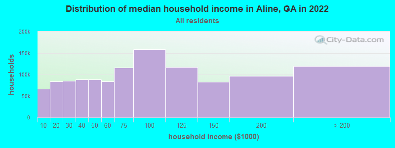
| Aline: | $46,113 |
| GA: | $72,837 |
Estimated per capita income in 2022: $19,499 (it was $10,177 in 2000)
Aline CCD income, earnings, and wages data
Estimated median house or condo value in 2022: $129,430 (it was $36,000 in 2000)
| Aline: | $129,430 |
| GA: | $297,400 |
Detailed information about poverty and poor residents in Aline, GA


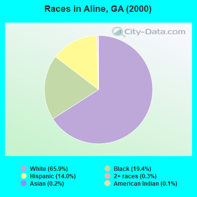
- 94065.9%White alone
- 27619.4%Black alone
- 20014.0%Hispanic
- 40.3%Two or more races
- 30.2%Asian alone
- 20.1%American Indian alone
- 10.07%Native Hawaiian and Other
Pacific Islander alone
Races in Aline detailed stats: ancestries, foreign born residents, place of birth
 Recent articles from our blog. Our writers, many of them Ph.D. graduates or candidates, create easy-to-read articles on a wide variety of topics.
Current Local Time: EST time zone
Elevation: 260 feet
Land area: 73.1 square miles.
Population density: 21 people per square mile (very low).

| Aline CCD: | 1.5% ($552) |
| Georgia: | 0.9% ($919) |
Nearest city with pop. 50,000+: Savannah, GA  (64.1 miles , pop. 131,510).
Nearest city with pop. 200,000+: Jacksonville, FL (143.2 miles , pop. 735,617).
Nearest city with pop. 1,000,000+: Philadelphia, PA (657.2 miles , pop. 1,517,550).
Nearest cities:
Latitude: 32.35 N, Longitude: 82.14 W
Area code commonly used in this area: 912

| Here: | 2.0% |
| Georgia: | 2.9% |
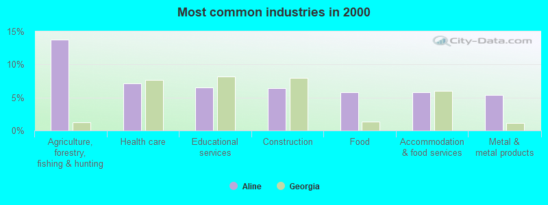
- Agriculture, forestry, fishing & hunting (13.7%)
- Health care (7.2%)
- Educational services (6.5%)
- Construction (6.4%)
- Food (5.7%)
- Accommodation & food services (5.7%)
- Metal & metal products (5.4%)
- Agriculture, forestry, fishing & hunting (19.4%)
- Construction (7.1%)
- Other transportation, support activities, couriers (6.9%)
- Rail transportation (6.1%)
- Repair & maintenance (5.6%)
- Metal & metal products (5.4%)
- Utilities (4.8%)
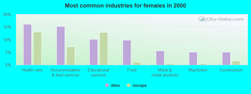
- Health care (16.2%)
- Accommodation & food services (15.3%)
- Educational services (10.2%)
- Food (9.8%)
- Metal & metal products (5.5%)
- Machinery (5.1%)
- Construction (5.1%)
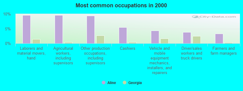
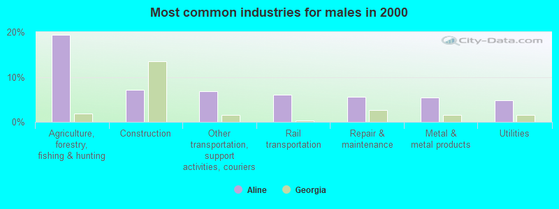
- Laborers and material movers, hand (9.6%)
- Agricultural workers, including supervisors (9.6%)
- Other production occupations, including supervisors (9.4%)
- Cashiers (5.4%)
- Vehicle and mobile equipment mechanics, installers, and repairers (4.3%)
- Driver/sales workers and truck drivers (3.8%)
- Farmers and farm managers (3.3%)
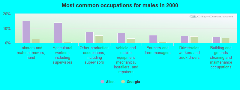
- Laborers and material movers, hand (15.3%)
- Agricultural workers, including supervisors (14.0%)
- Other production occupations, including supervisors (7.7%)
- Vehicle and mobile equipment mechanics, installers, and repairers (6.9%)
- Farmers and farm managers (5.4%)
- Driver/sales workers and truck drivers (4.8%)
- Building and grounds cleaning and maintenance occupations (4.1%)
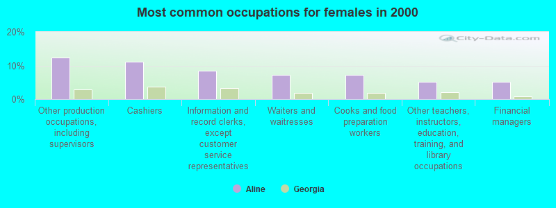
- Other production occupations, including supervisors (12.3%)
- Cashiers (11.1%)
- Information and record clerks, except customer service representatives (8.5%)
- Waiters and waitresses (7.2%)
- Cooks and food preparation workers (7.2%)
- Other teachers, instructors, education, training, and library occupations (5.1%)
- Financial managers (5.1%)
Average climate in Aline, Georgia
Based on data reported by over 4,000 weather stations


Tornado activity:
Aline-area historical tornado activity is slightly below Georgia state average. It is 11% smaller than the overall U.S. average.
On 5/11/2008, a category F3 (max. wind speeds 158-206 mph) tornado 7.5 miles away from the Aline place center injured 2 people and caused $1 million in damages.
On 5/11/2008, a category F3 tornado 25.7 miles away from the place center .
Earthquake activity:
Aline-area historical earthquake activity is significantly above Georgia state average. It is 30% smaller than the overall U.S. average.On 8/2/1974 at 08:52:09, a magnitude 4.9 (4.3 MB, 4.9 LG, Class: Light, Intensity: IV - V) earthquake occurred 107.3 miles away from the city center
On 11/22/1974 at 05:25:55, a magnitude 4.7 (4.7 MB) earthquake occurred 122.4 miles away from Aline center
On 8/21/1992 at 16:31:55, a magnitude 4.4 (4.1 MB, 4.1 LG, 4.4 LG, Depth: 6.2 mi) earthquake occurred 127.5 miles away from the city center
On 4/29/2003 at 08:59:39, a magnitude 4.9 (4.4 MB, 4.6 MW, 4.9 LG) earthquake occurred 250.1 miles away from the city center
On 8/9/2020 at 12:07:37, a magnitude 5.1 (5.1 MW, Depth: 4.7 mi, Class: Moderate, Intensity: VI - VII) earthquake occurred 291.6 miles away from Aline center
On 2/15/2014 at 03:23:38, a magnitude 4.1 (4.1 MW, Depth: 3.2 mi) earthquake occurred 101.6 miles away from the city center
Magnitude types: regional Lg-wave magnitude (LG), body-wave magnitude (MB), moment magnitude (MW)
Natural disasters:
The number of natural disasters in Candler County (12) is smaller than the US average (15).Major Disasters (Presidential) Declared: 6
Emergencies Declared: 5
Causes of natural disasters: Hurricanes: 4, Winter Storms: 3, Storms: 2, Tornadoes: 2, Drought: 1, Flood: 1, Snowfall: 1, Tropical Storm: 1, Other: 1 (Note: some incidents may be assigned to more than one category).
Hospitals and medical centers near Aline:
- AZALEA HEALTH AND REHABILITATION (Nursing Home, about 6 miles away; METTER, GA)
- CANDLER COUNTY DIALYSIS (Dialysis Facility, about 6 miles away; METTER, GA)
- CANDLER COUNTY HOSPITAL Critical Access Hospitals (about 6 miles away; METTER, GA)
- PLEASANT VIEW NURSING CENTER (Nursing Home, about 7 miles away; METTER, GA)
- OXLEY PARK HEALTH AND REHABILITATION (Nursing Home, about 16 miles away; LYONS, GA)
Colleges/universities with over 2000 students nearest to Aline:
- East Georgia State College (about 20 miles; Swainsboro, GA; Full-time enrollment: 2,345)
- Georgia Southern University (about 22 miles; Statesboro, GA; FT enrollment: 18,824)
- Armstrong Atlantic State University (about 63 miles; Savannah, GA; FT enrollment: 6,399)
- Savannah Technical College (about 65 miles; Savannah, GA; FT enrollment: 3,677)
- Savannah College of Art and Design (about 65 miles; Savannah, GA; FT enrollment: 9,964)
- South University–Savannah Online (about 66 miles; Savannah, GA; FT enrollment: 13,512)
- Savannah State University (about 67 miles; Savannah, GA; FT enrollment: 4,193)
Points of interest:
Churches in Aline include: Aline Church (A), Eden Church (B), Evergreen Church (C), New Eden Church (D), New Life Church (E), Piney Grove Church (F), Primitive Grove Church (G), Cool Springs Church (H), Steep Hill Church (I). Display/hide their locations on the map
Cemeteries: Saint Matthew Cemetery (1), Oak Chapel Cemetery (2). Display/hide their locations on the map
Reservoirs: Laniers Pond (A), Mac Wac Lake (B), Anderson Lake (C), Lewis Lake (D), West Lake (E), Glisson Lake (F), Boatright Lake (G). Display/hide their locations on the map
Creeks: Wolfe Creek (A), Jacks Creek (B), Reedy Creek (C). Display/hide their locations on the map
| This place: | 2.7 people |
| Georgia: | 2.6 people |
| This place: | 73.5% |
| Whole state: | 68.5% |
| This place: | 7.8% |
| Whole state: | 5.9% |
Likely homosexual households (counted as self-reported same-sex unmarried-partner households)
- Lesbian couples: 0.3% of all households
- Gay men: 0.2% of all households
| This place: | 24.7% |
| Whole state: | 13.0% |
| This place: | 9.3% |
| Whole state: | 6.1% |
For population 15 years and over in Aline:
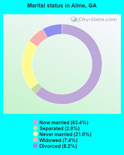
- Never married: 21.0%
- Now married: 63.4%
- Separated: 2.8%
- Widowed: 7.4%
- Divorced: 8.2%
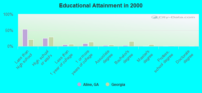
For population 25 years and over in Aline:
- High school or higher: 46.5%
- Bachelor's degree or higher: 4.5%
- Graduate or professional degree: 1.5%
- Unemployed: 8.1%
- Mean travel time to work (commute): 37.1 minutes
| Here: | 17.8 |
| Georgia average: | 13.3 |
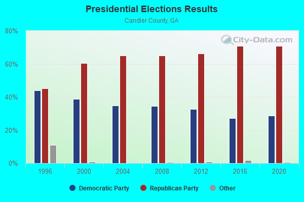
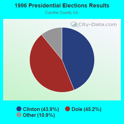


Graphs represent county-level data. Detailed 2008 Election Results
Religion statistics for Aline, GA (based on Candler County data)
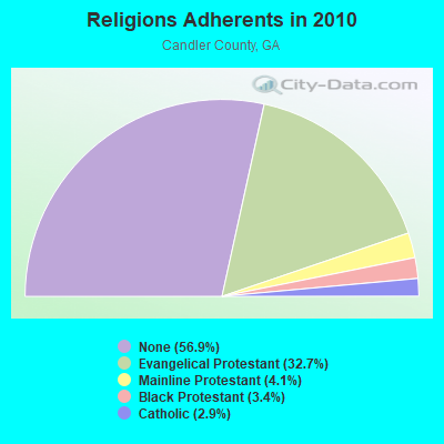
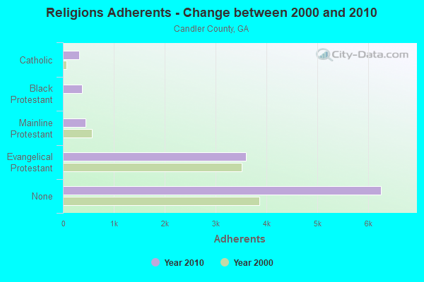
| Religion | Adherents | Congregations |
|---|---|---|
| Evangelical Protestant | 3,598 | 15 |
| Mainline Protestant | 451 | 4 |
| Black Protestant | 376 | 2 |
| Catholic | 319 | 1 |
| Other | - | 1 |
| None | 6,254 | - |
Food Environment Statistics:
| Candler County: | 1.91 / 10,000 pop. |
| Georgia: | 1.91 / 10,000 pop. |
| Candler County: | 1.91 / 10,000 pop. |
| Georgia: | 0.86 / 10,000 pop. |
| Candler County: | 10.49 / 10,000 pop. |
| State: | 5.12 / 10,000 pop. |
| Here: | 7.63 / 10,000 pop. |
| State: | 7.41 / 10,000 pop. |
| This county: | 12.6% |
| Georgia: | 10.4% |
| Candler County: | 30.4% |
| Georgia: | 27.8% |
| This county: | 19.1% |
| State: | 14.6% |
Strongest AM radio stations in Aline:
- WHCG (1360 AM; 1 kW; METTER, GA; Owner: RADIO METTER, INC.)
- WVOP (970 AM; 5 kW; VIDALIA, GA; Owner: VIDALIA COMMUNICATIONS CORPORATION)
- WMAC (940 AM; 50 kW; MACON, GA; Owner: CUMULUS LICENSING CORP.)
- WXRS (1590 AM; 2 kW; SWAINSBORO, GA; Owner: LACOM COMMUNICATIONS, INC.)
- WBBT (1340 AM; 1 kW; LYONS, GA; Owner: T.C.B. BROADCASTING, INC)
- WOKV (690 AM; 50 kW; JACKSONVILLE, FL; Owner: COX RADIO, INC.)
- WPTB (850 AM; 1 kW; STATESBORO, GA; Owner: COMMUNICATIONS CAPITAL COMPANY II OF GEORGIA, LLC)
- WBAJ (890 AM; daytime; 50 kW; BLYTHEWOOD, SC; Owner: FAMILY FIRST)
- WJAT (800 AM; 1 kW; SWAINSBORO, GA; Owner: LACOM COMMUNICATIONS, INC.)
- WGST (640 AM; 50 kW; ATLANTA, GA; Owner: CITICASTERS LICENSES, L.P.)
- WCEO (840 AM; daytime; 50 kW; COLUMBIA, SC; Owner: EASTERN BROADCASTING GROUP, INC.)
- WCNN (680 AM; 50 kW; NORTH ATLANTA, GA; Owner: DICKEY BROADCASTING COMPANY)
- WSB (750 AM; 50 kW; ATLANTA, GA; Owner: CXR HOLDINGS, INC.)
Strongest FM radio stations in Aline:
- WBMZ (104.9 FM; METTER, GA; Owner: WM. JIMMY PAGE, TR/AS RADIO METTER)
- WPMX (102.9 FM; STATESBORO, GA; Owner: MULTI-SERVICE CORP.)
- WMCD (100.1 FM; STATESBORO, GA; Owner: RADIO STATESBORO, INC.)
- WQZY (95.9 FM; DUBLIN, GA; Owner: STATE BROADCASTING CORPORATION)
- WGPH (91.5 FM; VIDALIA, GA; Owner: AUGUSTA RADIO FELLOWSHIP INSTITUTE,)
- WYUM (101.7 FM; MOUNT VERNON, GA; Owner: VIDALIA COMMUNICATIONS CORPORATION)
- WZAT (102.1 FM; SAVANNAH, GA; Owner: CUMULUS LICENSING CORP.)
- WRBX (104.1 FM; REIDSVILLE, GA; Owner: WRBX / WTNL, INC.)
- WTCQ (97.7 FM; VIDALIA, GA; Owner: VIDALIA COMMUNICATIONS CORPORATION)
- WAEV (97.3 FM; SAVANNAH, GA; Owner: CAPSTAR TX LIMITED PARTNERSHIP)
- WQBT (94.1 FM; SAVANNAH, GA; Owner: CAPSTAR TX LIMITED PARTNERSHIP)
- WBYZ (94.5 FM; BAXLEY, GA; Owner: SOUTH GEORGIA BROADCASTERS, INC.)
- WCLA-FM (107.3 FM; CLAXTON, GA; Owner: PROGRESSIVE UNITED COMM., INC.)
- WLYU (100.9 FM; LYONS, GA; Owner: T.C.B. BROADCASTING INC)
- WXRS-FM (100.5 FM; SWAINSBORO, GA; Owner: LACOM COMMUNICATIONS, INC.)
- WCGN (106.3 FM; GLENNVILLE, GA; Owner: BULLIE BROADCASTING CORPORATION)
TV broadcast stations around Aline:
- WGSA (Channel 34; BAXLEY, GA; Owner: SOUTHERN TV CORPORATION)
- WVAN-TV (Channel 9; SAVANNAH, GA; Owner: GEORGIA PUBLIC TELECOMMUNICATIONS COMMISSION)
- WTOC-TV (Channel 11; SAVANNAH, GA; Owner: RAYCOM AMERICA, INC.)
- WTGS (Channel 28; HARDEEVILLE, SC; Owner: BLUENOSE BROADCASTING OF SAVANNAH LLC)
- WJCL (Channel 22; SAVANNAH, GA; Owner: PIEDMONT TELEVISION OF SAVANNAH LICENSE LLC)
- WPHJ-CA (Channel 46; VIDALIA, GA; Owner: BARINOWSKI INVESTMENT COMPANY, L.P.)
- W48BH (Channel 48; STATESBORO, GA; Owner: TRINITY BROADCASTING NETWORK)
FCC Registered Antenna Towers:
7- Janis E Merritts, Route 2, County Road 172 (Lat: 32.324167 Lon: -82.183889), Type: 144.8, Overall height: 140.2 m, Registrant: Pinnacle Towers Inc., Pinnacle@pintowers.Com, , Saras-ota, Phone: (941) 364-8886
- Janis E Merritts, Route 2, County Road 172 (Lat: 32.324167 Lon: -82.183889), Type: 144.8, Overall height: 140.2 m, Registrant: Pinnacle Towers LLC, Compliancedepartment@gsignal.Com, , Saras-ota, Phone: (941) 364-8886
- Christine A Verre, Route 2, County Road 172 (Lat: 32.324167 Lon: -82.183889), Type: 144.8, Overall height: 140.2 m, Registrant: Crown Castle Usa, Christine.Verre@crowncastle.Com, , Canon-sburg, Phone: (336) 643-2524
- Lisa M Minney, Route 2, County Road 172 (Lat: 32.324167 Lon: -82.183889), Type: 144.8, Structure height: 13043 m, Overall height: 140.2 m, Licensee ID: L, Registrant: Pinnacle Towers LLC, Regulatory.Department@crowncastle.Com, , Canon-sburg, Phone: (724) 416-2000
- Lisa M m, Route 2, County Road 172 (Lat: 32.324167 Lon: -82.183889), Type: 144.8, Structure height: 13043 m, Overall height: 140.2 m, Registrant: Crown Castle, Don.Snyder@crowncastle.Com, , Canon-sburg, Phone: (724) 416-2470
- Route 2, County Road 172 (Lat: 32.324167 Lon: -82.183889), Type: 144.8, Overall height: 140.2 m, Registrant: Southern Communications Services, Inc., John.D.Logan@scsnet.Com, , Birmi-ngham, Phone: (205) 257-1843
- Route 2, County Road 172 (Lat: 32.324167 Lon: -82.183889), Type: 144.8, Overall height: 140.2 m, Registrant: Pinnacle Towers Inc., Jmerritts@pintowers.Com, , Saras-ota, Phone: (941) 364-8886
FCC Registered Private Land Mobile Towers:
2- Rt 2 Cr 172 (Lat: 32.324083 Lon: -82.184000), Type: Tower, Structure height: 140 m, Call Sign: WPBV319,
Assigned Frequencies: 859.312 MHz, 859.337 MHz, 859.362 MHz, 859.387 MHz, 859.412 MHz, 860.287 MHz, 860.312 MHz, 860.337 MHz, 860.362 MHz, 860.387 MHz, 860.412 MHz, Grant Date: 07/30/2019, Expiration Date: 06/08/2029, Registrant: Southern Communications Services, Inc D/B/A Southern Linc, 600 18th St N Bin Sn-0800, Birmingham, AL 35203-2206, Phone: (205) 257-1534, Email:
- Rt 2 Cr 172 (Lat: 32.324083 Lon: -82.184000), Type: Tower, Structure height: 140 m, Call Sign: WQJM606,
Assigned Frequencies: 858.337 MHz, Grant Date: 04/28/2009, Expiration Date: 06/08/2019, Cancellation Date: 05/21/2013, Certifier: Robin J Cohen, Registrant: Sprint Nextel Corporation, 12502 Sunrise Valley Drive, Reston, VA 20191, Phone: (703) 433-4000, Fax: (703) 433-4483
FCC Registered Microwave Towers:
2- METTER, Route 2, County Road 172 (Lat: 32.324167 Lon: -82.183889), Type: Gtower, Structure height: 140.2 m, Overall height: 144.8 m, Call Sign: WPNG398,
Assigned Frequencies: 6800.00 MHz, 6750.00 MHz, 6825.00 MHz, 11465.0 MHz, 11505.0 MHz, 11465.0 MHz, 11505.0 MHz, 11465.0 MHz, 11505.0 MHz, 11465.0 MHz... (+9 more), Grant Date: 04/24/2018, Expiration Date: 03/26/2028, Registrant: Southern Company Services, 600 N. 18th St / Bin 5n-5409, Birmingham, AL 35203, Phone: (205) 257-7600, Fax: (205) 257-2134, Email:
- METTER, Rte 2, Cr172 (Lat: 32.324194 Lon: -82.183722), Overall height: 144.8 m, Call Sign: WPOQ652,
Assigned Frequencies: 952.318 MHz, 928.318 MHz, Grant Date: 12/20/2018, Expiration Date: 01/19/2029, Registrant: Southern Company Services, 600 N. 18th St / Bin 5n-5409, Birmingham, AL 35203, Phone: (205) 257-7600, Fax: (205) 257-2134, Email:
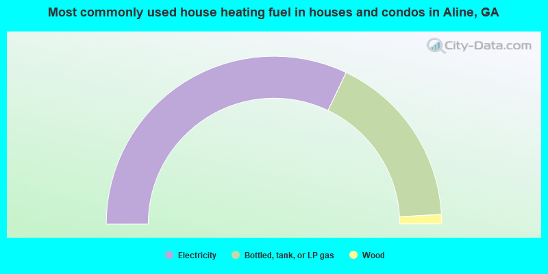
- 64.1%Electricity
- 34.0%Bottled, tank, or LP gas
- 1.8%Wood
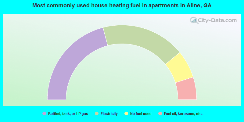
- 41.8%Bottled, tank, or LP gas
- 36.4%Electricity
- 12.0%No fuel used
- 9.8%Fuel oil, kerosene, etc.
Aline compared to Georgia state average:
- Median household income below state average.
- Median house value significantly below state average.
- Unemployed percentage below state average.
- Median age below state average.
- Foreign-born population percentage significantly below state average.
- Length of stay since moving in significantly above state average.
- Number of rooms per house significantly below state average.
- House age significantly below state average.
- Number of college students below state average.
- Percentage of population with a bachelor's degree or higher significantly below state average.