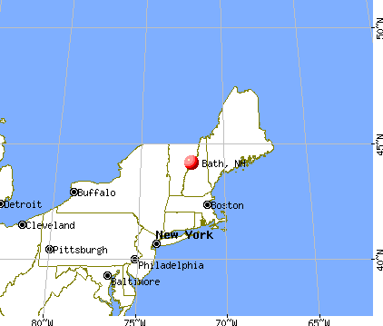
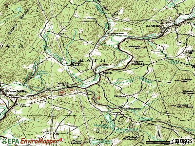
Bath, New Hampshire
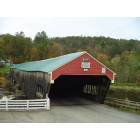
Bath: Bath Covered Bridge, Bath, NH
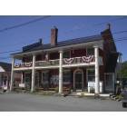
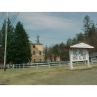
Bath: Oldest general store in USA
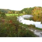
Bath: Wild Ammonoosuc River, Bath NH
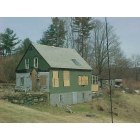
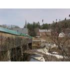
Bath: Poverty in small town Bath,NH
Bath: Old 1800's Colonial Inn, Bath,NH
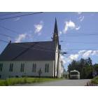
Bath: Church located near the covered bridge and general store
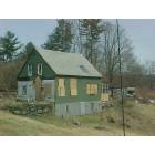
Bath: Poverty in small town Bath,NH
Bath: Bath bridge from west side
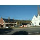
Bath: Bath Store and Church
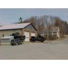
Bath: Town Garage Bath,NH
- add
your
Submit your own pictures of this town and show them to the world
- OSM Map
- General Map
- Google Map
- MSN Map

Population change since 2000: +20.6%
| Males: 565 | |
| Females: 512 |
| Median resident age: | 46.5 years |
| New Hampshire median age: | 43.9 years |
Zip codes: 03785.
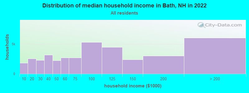
| Bath: | $84,247 |
| NH: | $89,992 |
Estimated per capita income in 2022: $40,741 (it was $17,916 in 2000)
Bath town income, earnings, and wages data
Estimated median house or condo value in 2022: $285,743 (it was $89,400 in 2000)
| Bath: | $285,743 |
| NH: | $384,700 |
Mean prices in 2022: all housing units: $486,096; detached houses: $533,852; townhouses or other attached units: $375,744; in 2-unit structures: $230,260; in 3-to-4-unit structures: $242,363; in 5-or-more-unit structures: $588,257; mobile homes: $127,035
Detailed information about poverty and poor residents in Bath, NH


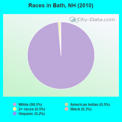
- 1,06198.5%White alone
- 50.5%American Indian alone
- 50.5%Two or more races
- 30.3%Black alone
- 20.2%Hispanic
- 10.09%Asian alone
Races in Bath detailed stats: ancestries, foreign born residents, place of birth
According to our research of New Hampshire and other state lists, there was 1 registered sex offender living in Bath, New Hampshire as of April 27, 2024.
The ratio of all residents to sex offenders in Bath is 1,077 to 1.
The ratio of registered sex offenders to all residents in this city is lower than the state average.
Type |
2019 |
2020 |
2021 |
2022 |
|---|---|---|---|---|
| Murders (per 100,000) | 0 (0.0) | 0 (0.0) | 0 (0.0) | 0 (0.0) |
| Rapes (per 100,000) | 0 (0.0) | 0 (0.0) | 0 (0.0) | 0 (0.0) |
| Robberies (per 100,000) | 0 (0.0) | 0 (0.0) | 0 (0.0) | 0 (0.0) |
| Assaults (per 100,000) | 0 (0.0) | 0 (0.0) | 0 (0.0) | 1 (90.1) |
| Burglaries (per 100,000) | 0 (0.0) | 0 (0.0) | 0 (0.0) | 0 (0.0) |
| Thefts (per 100,000) | 0 (0.0) | 7 (639.3) | 11 (991.0) | 2 (180.2) |
| Auto thefts (per 100,000) | 1 (91.5) | 2 (182.6) | 0 (0.0) | 0 (0.0) |
| Arson (per 100,000) | 0 (0.0) | 1 (91.3) | 0 (0.0) | 0 (0.0) |
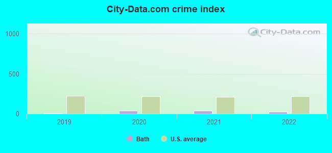
| City-Data.com crime index | 7.3 | 40.2 | 39.6 | 25.2 |
The City-Data.com crime index weighs serious crimes and violent crimes more heavily. Higher means more crime, U.S. average is 246.1. It adjusts for the number of visitors and daily workers commuting into cities.
Crime rate in Bath detailed stats: murders, rapes, robberies, assaults, burglaries, thefts, arson
 Recent articles from our blog. Our writers, many of them Ph.D. graduates or candidates, create easy-to-read articles on a wide variety of topics.

 | Public Water in Bath, NH (1 reply) |
| Second property on land near White Mountains (20 replies) |
| Cog railway (7 replies) |
| Meredith NH - Other Towns? (30 replies) |
| 1 Day in New Hampshire (10 replies) |
| Places we must see? (13 replies) |
Latest news from Bath, NH collected exclusively by city-data.com from local newspapers, TV, and radio stations
Ancestries: English (26.7%), Irish (15.6%), French (13.8%), United States (12.2%), Scottish (7.4%), German (6.9%).
Current Local Time: EST time zone
Incorporated in 1761
Elevation: 595 feet
Land area: 38.2 square miles.
Population density: 28 people per square mile (very low).
15 residents are foreign born
| This town: | 1.7% |
| New Hampshire: | 4.4% |
| Bath town: | 1.8% ($1,579) |
| New Hampshire: | 2.3% ($2,946) |
Nearest city with pop. 50,000+: Manchester, NH  (85.0 miles , pop. 107,006).
Nearest city with pop. 200,000+: Boston, MA (134.5 miles , pop. 589,141).
Nearest city with pop. 1,000,000+: Bronx, NY (248.3 miles , pop. 1,332,650).
Nearest cities:
), ), )Latitude: 44.15 N, Longitude: 71.98 W

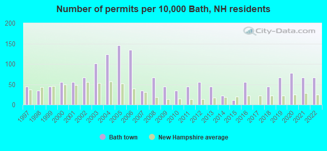
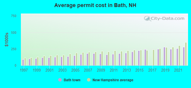
Single-family new house construction building permits:
- 2022: 6 buildings, average cost: $279,200
- 2021: 6 buildings, average cost: $259,200
- 2020: 7 buildings, average cost: $248,200
- 2019: 6 buildings, average cost: $282,200
- 2018: 4 buildings, average cost: $249,800
- 2016: 5 buildings, average cost: $246,000
- 2015: 1 building, cost: $226,800
- 2014: 2 buildings, average cost: $211,200
- 2013: 4 buildings, average cost: $193,300
- 2012: 5 buildings, average cost: $184,000
- 2011: 4 buildings, average cost: $172,800
- 2010: 3 buildings, average cost: $165,900
- 2009: 4 buildings, average cost: $178,900
- 2008: 6 buildings, average cost: $182,400
- 2007: 3 buildings, average cost: $181,200
- 2006: 12 buildings, average cost: $171,000
- 2005: 13 buildings, average cost: $150,200
- 2004: 11 buildings, average cost: $138,800
- 2003: 9 buildings, average cost: $132,800
- 2002: 6 buildings, average cost: $130,700
- 2001: 5 buildings, average cost: $121,400
- 2000: 5 buildings, average cost: $118,000
- 1999: 4 buildings, average cost: $109,200
- 1998: 3 buildings, average cost: $101,700
- 1997: 4 buildings, average cost: $91,700
| Here: | 1.9% |
| New Hampshire: | 2.5% |
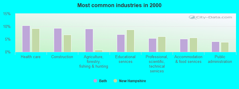
- Health care (10.3%)
- Construction (9.2%)
- Agriculture, forestry, fishing & hunting (9.0%)
- Educational services (6.9%)
- Professional, scientific, technical services (5.4%)
- Accommodation & food services (5.2%)
- Public administration (4.1%)
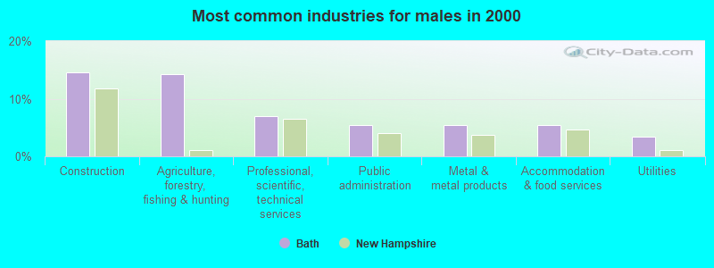
- Construction (14.6%)
- Agriculture, forestry, fishing & hunting (14.2%)
- Professional, scientific, technical services (6.9%)
- Public administration (5.4%)
- Metal & metal products (5.4%)
- Accommodation & food services (5.4%)
- Utilities (3.5%)
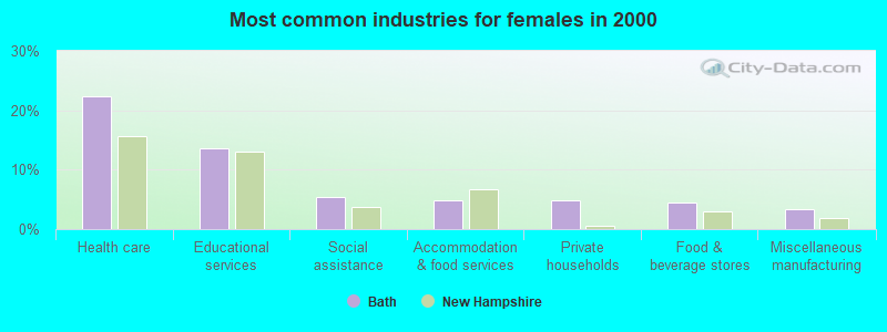
- Health care (22.4%)
- Educational services (13.7%)
- Social assistance (5.4%)
- Accommodation & food services (4.9%)
- Private households (4.9%)
- Food & beverage stores (4.4%)
- Miscellaneous manufacturing (3.4%)
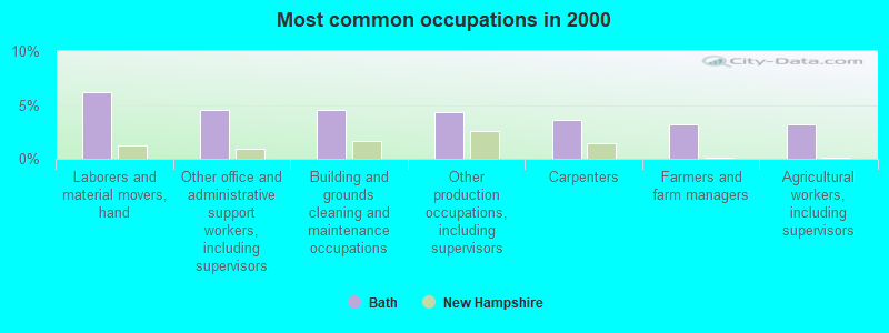
- Laborers and material movers, hand (6.2%)
- Other office and administrative support workers, including supervisors (4.5%)
- Building and grounds cleaning and maintenance occupations (4.5%)
- Other production occupations, including supervisors (4.3%)
- Carpenters (3.7%)
- Farmers and farm managers (3.2%)
- Agricultural workers, including supervisors (3.2%)
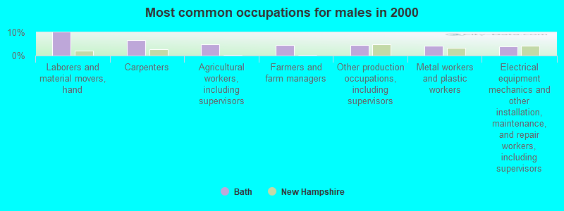
- Laborers and material movers, hand (10.0%)
- Carpenters (6.5%)
- Agricultural workers, including supervisors (5.0%)
- Farmers and farm managers (4.6%)
- Other production occupations, including supervisors (4.6%)
- Metal workers and plastic workers (4.2%)
- Electrical equipment mechanics and other installation, maintenance, and repair workers, including supervisors (3.8%)
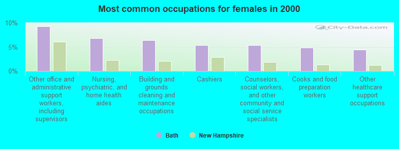
- Other office and administrative support workers, including supervisors (9.3%)
- Nursing, psychiatric, and home health aides (6.8%)
- Building and grounds cleaning and maintenance occupations (6.3%)
- Cashiers (5.4%)
- Counselors, social workers, and other community and social service specialists (5.4%)
- Cooks and food preparation workers (4.9%)
- Other healthcare support occupations (4.4%)
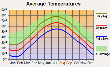
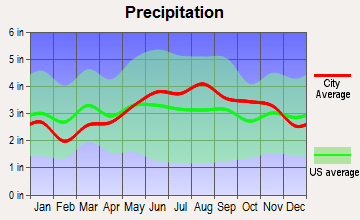
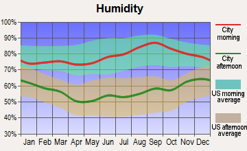
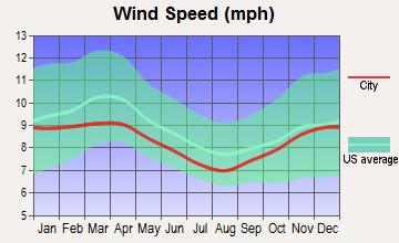
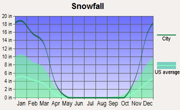
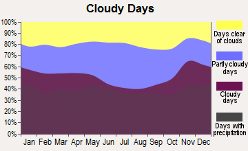
Average climate in Bath, New Hampshire
Based on data reported by over 4,000 weather stations
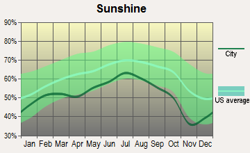
(lower is better)
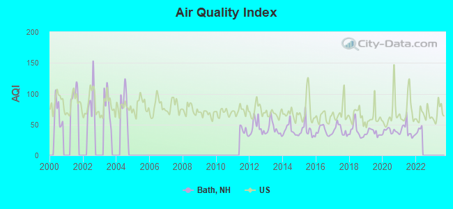
Air Quality Index (AQI) level in 2021 was 39.8. This is significantly better than average.
| City: | 39.8 |
| U.S.: | 72.6 |
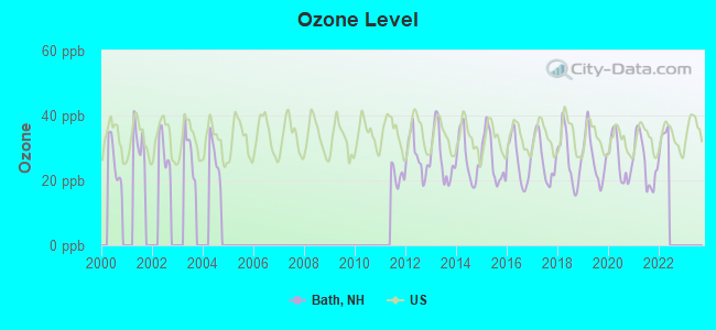
Ozone [ppb] level in 2021 was 25.7. This is better than average. Closest monitor was 5.1 miles away from the city center.
| City: | 25.7 |
| U.S.: | 33.3 |
Earthquake activity:
Bath-area historical earthquake activity is significantly above New Hampshire state average. It is 72% smaller than the overall U.S. average.On 4/20/2002 at 10:50:47, a magnitude 5.3 (5.3 ML, Depth: 3.0 mi, Class: Moderate, Intensity: VI - VII) earthquake occurred 88.4 miles away from the city center
On 4/20/2002 at 10:50:47, a magnitude 5.2 (5.2 MB, 4.2 MS, 5.2 MW, 5.0 MW) earthquake occurred 89.0 miles away from Bath center
On 10/7/1983 at 10:18:46, a magnitude 5.3 (5.1 MB, 5.3 LG, 5.1 ML) earthquake occurred 118.1 miles away from the city center
On 1/19/1982 at 00:14:42, a magnitude 4.7 (4.5 MB, 4.7 MD, 4.5 LG, Class: Light, Intensity: IV - V) earthquake occurred 49.1 miles away from the city center
On 10/16/2012 at 23:12:25, a magnitude 4.7 (4.7 ML, Depth: 10.0 mi) earthquake occurred 76.5 miles away from Bath center
On 6/16/1995 at 12:13:11, a magnitude 3.8 (3.8 LG, Depth: 3.1 mi, Class: Light, Intensity: II - III) earthquake occurred 9.7 miles away from the city center
Magnitude types: regional Lg-wave magnitude (LG), body-wave magnitude (MB), duration magnitude (MD), local magnitude (ML), surface-wave magnitude (MS), moment magnitude (MW)
Natural disasters:
The number of natural disasters in Grafton County (32) is a lot greater than the US average (15).Major Disasters (Presidential) Declared: 20
Emergencies Declared: 9
Causes of natural disasters: Floods: 16, Storms: 16, Hurricanes: 3, Snows: 3, Winter Storms: 3, Tropical Storms: 2, Blizzard: 1, Heavy Rain: 1, Ice Storm: 1, Landslide: 1, Snowfall: 1, Snowstorm: 1, Wind: 1, Other: 1 (Note: some incidents may be assigned to more than one category).
Hospitals and medical centers near Bath:
- COTTAGE HOSPITAL Critical Access Hospitals (about 4 miles away; WOODSVILLE, NH)
- GRAFTON COUNTY NURSING HOME (Nursing Home, about 6 miles away; NORTH HAVERHILL, NH)
- GLENCLIFF HOME FOR THE ELDERLY (Nursing Home, about 13 miles away; GLENCLIFF, NH)
- LAFAYETTE CENTER, GENESIS HEALTHCARE (Nursing Home, about 13 miles away; FRANCONIA, NH)
- NORTH COUNTRY HOME HEALTH AND HOSPICE AGENCY (Home Health Center, about 15 miles away; LITTLETON, NH)
Colleges/universities with over 2000 students nearest to Bath:
- Plymouth State University (about 32 miles; Plymouth, NH; Full-time enrollment: 4,838)
- Norwich University (about 34 miles; Northfield, VT; FT enrollment: 4,221)
- Dartmouth College (about 35 miles; Hanover, NH; FT enrollment: 6,030)
- Middlebury College (about 61 miles; Middlebury, VT; FT enrollment: 3,077)
- Saint Michael's College (about 64 miles; Colchester, VT; FT enrollment: 2,336)
- Community College of Vermont (about 64 miles; Winooski, VT; FT enrollment: 3,394)
- University of Vermont (about 65 miles; Burlington, VT; FT enrollment: 11,566)
Public elementary/middle school in Bath:
- BATH VILLAGE SCHOOL (Students: 58, Location: 61 LISBON RD., Grades: KG-6)
Points of interest:
Notable locations in Bath: Bath Volunteer Fire Department (A), Bath Town Hall (B), Bath Public Library (C). Display/hide their locations on the map
Church in Bath: Bath Congregational Church (A). Display/hide its location on the map
Cemeteries: Pettyboro District Cemetery (1), Swiftwater District Cemetery (2), Hamm Cemetery (3), Carbee Cemetery (4), Saint Josephs Cemetery (5), Bath Cemetery (6). Display/hide their locations on the map
Lakes and reservoirs: Lake Gardner (A), Connecticut River Reservoir (B), Ammonoosuc River Reservoir (C). Display/hide their locations on the map
Streams, rivers, and creeks: Childs Brook (A), Ammonoosuc River (B), Petty Brook (C), Pettyboro Brook (D), Simonds Brook (E), Burton Brook (F), Waterman Brook (G). Display/hide their locations on the map
Drinking water stations with addresses in Bath and their reported violations in the past:
TWIN RIVERS CAMPGROUND (Population served: 182, Groundwater):Past health violations:BATH VILLAGE WATER WORKS (Population served: 95, Groundwater):Past monitoring violations:
- MCL, Monthly (TCR) - Between JUL-2007 and SEP-2007, Contaminant: Coliform. Follow-up actions: St Public Notif requested (AUG-16-2007), St Violation/Reminder Notice (AUG-16-2007), St Public Notif requested (AUG-16-2007), St Violation/Reminder Notice (AUG-16-2007), St Public Notif received (SEP-10-2007), St Formal NOV issued (DEC-06-2007), St Compliance achieved (SEP-25-2008)
- MCL, Monthly (TCR) - Between JUL-2006 and SEP-2006, Contaminant: Coliform. Follow-up actions: St Public Notif requested (AUG-16-2006), St Violation/Reminder Notice (AUG-16-2006), St Public Notif received (SEP-12-2006), St Compliance achieved (MAY-31-2007)
- One routine major monitoring violation
Past health violations:TWIN RIVERS CAMPGRND/RIVERSIDE (Population served: 33, Groundwater):
- MCL, Monthly (TCR) - In FEB-2007, Contaminant: Coliform. Follow-up actions: St Public Notif requested (FEB-21-2007), St Violation/Reminder Notice (FEB-21-2007), St Public Notif received (MAR-09-2007), St Compliance achieved (AUG-29-2007)
Past health violations:
- MCL, Monthly (TCR) - Between JUL-2009 and SEP-2009, Contaminant: Coliform. Follow-up actions: St Violation/Reminder Notice (AUG-20-2009), St Public Notif requested (AUG-20-2009), St Public Notif received (SEP-08-2009), St Compliance achieved (MAY-25-2010)
| This town: | 2.5 people |
| New Hampshire: | 2.5 people |
| This town: | 71.2% |
| Whole state: | 66.3% |
| This town: | 6.7% |
| Whole state: | 8.3% |
Likely homosexual households (counted as self-reported same-sex unmarried-partner households)
- Lesbian couples: 0.5% of all households
- Gay men: 0.5% of all households
| This town: | 5.1% |
| Whole state: | 6.5% |
| This town: | 2.3% |
| Whole state: | 2.8% |
For population 15 years and over in Bath:
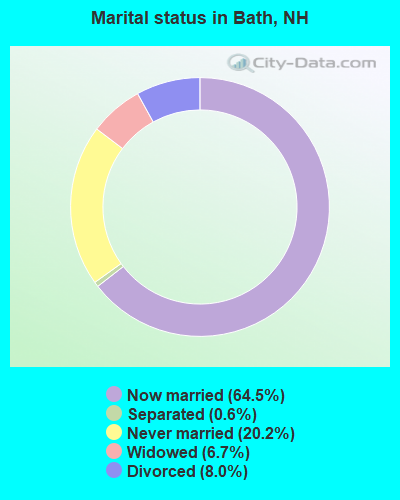
- Never married: 20.2%
- Now married: 64.5%
- Separated: 0.6%
- Widowed: 6.7%
- Divorced: 8.0%
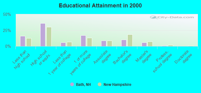
For population 25 years and over in Bath:
- High school or higher: 83.8%
- Bachelor's degree or higher: 16.7%
- Graduate or professional degree: 6.4%
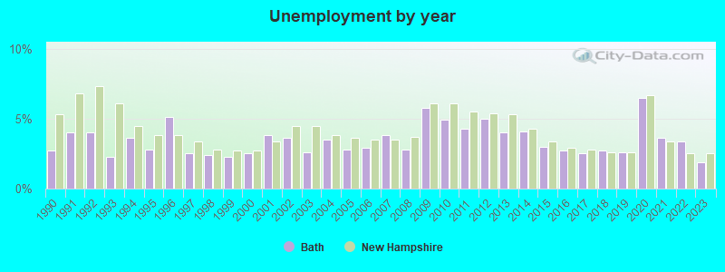
- Unemployed: 4.9%
- Mean travel time to work (commute): 22.2 minutes
| Here: | 10.0 |
| New Hampshire average: | 10.9 |


Graphs represent county-level data. Detailed 2008 Election Results
Religion statistics for Bath, NH (based on Grafton County data)


| Religion | Adherents | Congregations |
|---|---|---|
| Catholic | 9,503 | 12 |
| Mainline Protestant | 7,832 | 57 |
| Evangelical Protestant | 1,494 | 29 |
| Other | 1,320 | 11 |
| None | 68,969 | - |
Food Environment Statistics:
| Grafton County: | 3.87 / 10,000 pop. |
| New Hampshire: | 2.14 / 10,000 pop. |
| This county: | 0.23 / 10,000 pop. |
| State: | 0.15 / 10,000 pop. |
| Grafton County: | 1.29 / 10,000 pop. |
| New Hampshire: | 1.78 / 10,000 pop. |
| Grafton County: | 6.45 / 10,000 pop. |
| State: | 4.02 / 10,000 pop. |
| Here: | 14.41 / 10,000 pop. |
| State: | 9.70 / 10,000 pop. |
| This county: | 7.2% |
| New Hampshire: | 7.6% |
| Grafton County: | 22.9% |
| New Hampshire: | 24.4% |
| This county: | 15.9% |
| State: | 15.9% |
Businesses in Bath, NH
- YMCA: 1
Strongest AM radio stations in Bath:
- WTWN (1100 AM; daytime; 5 kW; WELLS RIVER, VT; Owner: PUFFER BROADCASTING, INC.)
- WCHP (760 AM; 35 kW; CHAMPLAIN, NY; Owner: CHAMPLAIN RADIO, INC.)
- WDEV (550 AM; 5 kW; WATERBURY, VT; Owner: RADIO VERMONT, INC.)
- WRKO (680 AM; 50 kW; BOSTON, MA; Owner: ENTERCOM BOSTON LICENSE, LLC)
- WPNH (1300 AM; 5 kW; PLYMOUTH, NH; Owner: NORTHEAST COMMUNICATIONS CORPORATION)
- WNNZ (640 AM; 50 kW; WESTFIELD, MA; Owner: CLEAR CHANNEL BROADCASTING LICENSES, INC.)
- WCRN (830 AM; 50 kW; WORCESTER, MA; Owner: CARTER BROADCASTING CORPORATION)
- WEEI (850 AM; 50 kW; BOSTON, MA; Owner: ENTERCOM BOSTON LICENSE, LLC)
- WNTK (1020 AM; 10 kW; NEWPORT, NH; Owner: KOOR COMMUNICATIONS, INC.)
- WLTN (1400 AM; 1 kW; LITTLETON, NH; Owner: PROFILE BROADCASTING COMPANY, INC.)
- WGY (810 AM; 50 kW; SCHENECTADY, NY; Owner: CLEAR CHANNEL BROADCASTING LICENSES, INC.)
- WBZ (1030 AM; 50 kW; BOSTON, MA; Owner: INFINITY BROADCASTING OPERATIONS, INC.)
- WKOX (1200 AM; 50 kW; FRAMINGHAM, MA; Owner: CAPSTAR TX LIMITED PARTNERSHIP)
Strongest FM radio stations in Bath:
- WYKR-FM (101.3 FM; HAVERHILL, NH; Owner: PUFFER BROADCASTING, INC.)
- WLTN-FM (96.7 FM; LISBON, NH; Owner: PROFILE BROADCASTING CO., INC.)
- WPKQ (103.7 FM; NORTH CONWAY, NH; Owner: CITADEL BROADCASTING COMPANY)
- WHOM (94.9 FM; MT. WASHINGTON, NH; Owner: CITADEL BROADCASTING COMPANY)
- WVFM (105.7 FM; CAMPTON, NH; Owner: DEVON BROADCASTING COMPANY, INC.)
- WMTK (106.3 FM; LITTLETON, NH; Owner: VERMONT BROADCAST ASSOCIATES, INC.)
- WGMT (97.7 FM; LYNDON, VT; Owner: VERMONT BROADCAST ASSOCIATES, INC.)
- WDOT (95.7 FM; DANVILLE, VT; Owner: MONTPELIER BROADCASTING INC)
- WCVT (101.7 FM; STOWE, VT; Owner: RADIO VERMONT CLASSICS, L.L.C.)
- WCKJ (90.5 FM; ST. JOHNSBURY, VT; Owner: CHRISTIAN MINISTRIES, INC.)
- WKXH (105.5 FM; ST. JOHNSBURY, VT; Owner: VERMONT BROADCAST ASSOCIATES, INC.)
- WLKC (103.3 FM; WATERBURY, VT; Owner: RADIO BROADCASTING SERVICES, INC.)
- WVPS (107.9 FM; BURLINGTON, VT; Owner: VERMONT PUBLIC RADIO)
- WEZF (92.9 FM; BURLINGTON, VT; Owner: CAPSTAR TX LIMITED PARTNERSHIP)
- WXXS (102.3 FM; LANCASTER, NH; Owner: BARRY P. LUNDERVILLE)
- WSCY (106.9 FM; MOULTONBOROUGH, NH; Owner: NORTHEAST COMMUNICATIONS CORPORATION)
- WDEV-FM (96.1 FM; WARREN, VT; Owner: RADIO VERMONT, INC.)
- WPNH-FM (100.1 FM; PLYMOUTH, NH; Owner: NORTHEAST COMMUNICATIONS CORPORATION)
- WNCS (104.7 FM; MONTPELIER, VT; Owner: MONTPELIER BROADCASTING, INC.)
- WEVH (91.3 FM; HANOVER, NH; Owner: NEW HAMPSHIRE PUBLIC RADIO INC)
TV broadcast stations around Bath:
- WLED-TV (Channel 49; LITTLETON, NH; Owner: UNIVERSITY OF NEW HAMPSHIRE)
Medal of Honor Recipients
Medal of Honor Recipient born in Bath: Francis H. Goodall.
- Bath, New Hampshire
- Fatal accident count10
- Vehicles involved in fatal accidents12
- Fatal accidents involving drunk persons:2
- Fatalities10
- Persons involved in fatal accidents21
- Pedestrians involved in fatal accidents1
- New Hampshire average
- Fatal accident count909
- Vehicles involved in fatal accidents1344
- Fatal accidents involving drunk persons296
- Fatalities995
- Persons involved in fatal accidents2133
- Pedestrians involved in fatal accidents123
- National Bridge Inventory (NBI) Statistics
- 6Number of bridges
- 151ft / 46.2mTotal length
- $18,852,000Total costs
- 10,555Total average daily traffic
- 724Total average daily truck traffic
- 15,617Total future (year 2042) average daily traffic
FCC Registered Antenna Towers:
7- Anthony Handley, 172 Goose Lane (Lat: 44.137361 Lon: -71.983667), Type: 53.3, Structure height: 33009 m, Overall height: 51.8 m, Registrant: Blue Sky Towers Iii, LLC, Chuck.Laurette@blueskytower.Com, Suite 106, 9607958 North- Reading, Phone: (888) 960-7958
- Anthony Handley, 172 Goose Lane (Lat: 44.137333 Lon: -71.983667), Type: 53.3, Structure height: 33009 m, Overall height: 51.8 m, Registrant: Blue Sky Towers Iii, LLC, Chuck.Laurette@blueskytower.Com, Suite 106, North- Reading, Phone: (888) 960-7958
- Anthony Handley, 172 Goose Lane (Lat: 44.137333 Lon: -71.983667), Type: 53.3, Structure height: 33009 m, Overall height: 51.8 m, Registrant: Blue Sky Towers Iii, LLC, Chuck.Laurette@blueskytower.Com, Suite 106, North- Reading, Phone: (888) 960-7958
- Anthony Handley, 172 Goose Lane (Lat: 44.137333 Lon: -71.983667), Type: 53.3, Structure height: 33009 m, Overall height: 51.8 m, Registrant: Blue Sky Towers Iii, LLC, Chuck.Laurette@blueskytower.Com, Suite 106, North- Reading, Phone: (888) 960-7958
- Anthony Handley, 172 Goose Lane (Lat: 44.137333 Lon: -71.983667), Type: 53.3, Structure height: 33009 m, Overall height: 51.8 m, Registrant: Blue Sky Towers Iii, LLC, Chuck.Laurette@blueskytower.Com, Suite 106, North- Reading, Phone: (888) 960-7958
- Anthony Handley, 172 Goose Lane (Lat: 44.137500 Lon: -71.983111), Type: 53.3, Structure height: 33009 m, Overall height: 51.8 m, Registrant: Blue Sky Towers Iii, LLC, Chuck.Laurette@blueskytower.Com, Suite 106, North- Reading, Phone: (888) 960-7958
- Anthony Handley, 172 Goose Lane (Lat: 44.137500 Lon: -71.983111), Type: 53.3, Structure height: 33009 m, Overall height: 51.8 m, Registrant: Blue Sky Towers Iii, LLC, Chuck.Laurette@blueskytower.Com, Suite 106, North- Reading, Phone: (888) 960-7958
FCC Registered Broadcast Land Mobile Towers:
3- Lat: 44.187556 Lon: -71.949528, Call Sign: KB29015,
Assigned Frequencies: 467.850 MHz, 467.925 MHz, Grant Date: 01/18/2023, Expiration Date: 04/01/2033, Certifier: Robert Moses, Registrant: Britton Lumber Company, LLC, Fairlee, VT 05045, Phone: (802) 333-4388, Email:
- Swiftwater Rd 1 Km Se Of Us Rt 302 (Lat: 44.143111 Lon: -72.000361), Type: Tower, Structure height: 30 m, Call Sign: WNHH944,
Assigned Frequencies: 153.425 MHz, 153.455 MHz, 153.725 MHz, Grant Date: 09/08/2011, Expiration Date: 11/04/2021, Cancellation Date: 03/07/2014, Certifier: Donald J Rendall Jr, Registrant: Green Mountain Power Corporation, 2152 Post Rd, Rutland, VT 05701, Phone: (802) 747-5655, Fax: (802) 229-7841, Email:
- Swift Water Rd 1/2 Mi Se Of Us 302 (Lat: 44.143111 Lon: -72.000361), Call Sign: WNUU231,
Assigned Frequencies: 48.0400 MHz, Grant Date: 10/12/2005, Expiration Date: 11/07/2015, Cancellation Date: 09/23/2015, Registrant: Green Mountain Power Corporation, 2152 Post Rd, Rutland, VT 05701, Phone: (802) 747-5655, Email:
FCC Registered Microwave Towers:
1- WOODSVILLE, Swift Water Rd, 0.5 Mi Se Rt 302 (Lat: 44.143111 Lon: -72.000361), Type: Tower, Structure height: 30.4 m, Overall height: 36.3 m, Call Sign: WPQL534, Licensee ID: L00117818,
Assigned Frequencies: 957.550 MHz, Grant Date: 05/16/2000, Expiration Date: 05/16/2010, Cancellation Date: 07/17/2010, Certifier: James J Allen, Registrant: Central Vermont Public Service Corp, 77 Grove St, Rutland, VT 05701, Phone: (802) 747-5776, Fax: (802) 747-2137, Email:
FCC Registered Amateur Radio Licenses:
16 (See the full list of FCC Registered Amateur Radio Licenses in Bath)2004 - 2018 National Fire Incident Reporting System (NFIRS) incidents
- Fire incident types reported to NFIRS in Bath, NH
- 4946.7%Structure Fires
- 3735.2%Outside Fires
- 109.5%Mobile Property/Vehicle Fires
- 98.6%Other
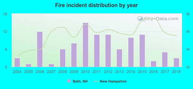 Based on the data from the years 2004 - 2018 the average number of fire incidents per year is 7. The highest number of fires - 15 took place in 2010, and the least - 1 in 2005. The data has a constant trend.
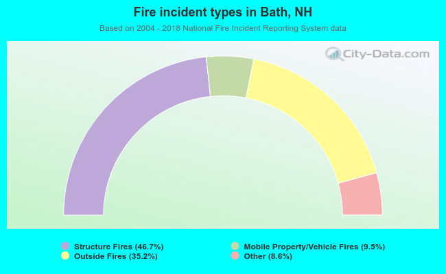 When looking into fire subcategories, the most incidents belonged to: Structure Fires (46.7%), and Outside Fires (35.2%).
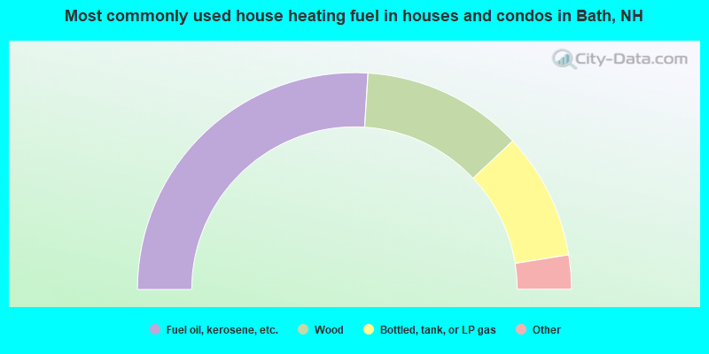
- 52.0%Fuel oil, kerosene, etc.
- 24.0%Wood
- 18.9%Bottled, tank, or LP gas
- 2.5%Utility gas
- 2.5%Electricity
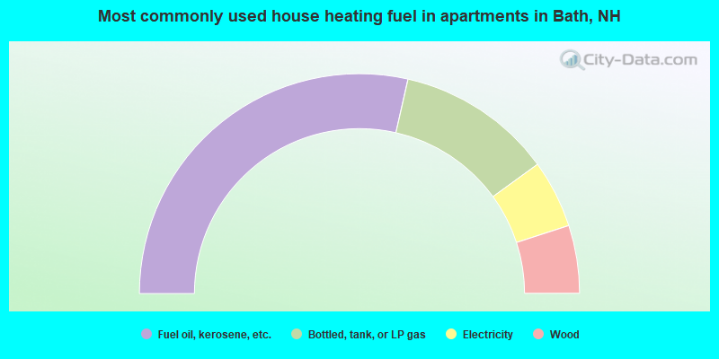
- 57.1%Fuel oil, kerosene, etc.
- 22.9%Bottled, tank, or LP gas
- 10.0%Electricity
- 10.0%Wood
Bath compared to New Hampshire state average:
- Unemployed percentage below state average.
- Black race population percentage significantly below state average.
- Hispanic race population percentage significantly below state average.
- Foreign-born population percentage significantly below state average.
- Renting percentage below state average.
- Length of stay since moving in significantly above state average.
- Number of rooms per house significantly below state average.
- House age significantly below state average.
- Number of college students below state average.
- Percentage of population with a bachelor's degree or higher below state average.

|
Total of 2 patent applications in 2008-2024.